Embed Size (px)
Citation preview
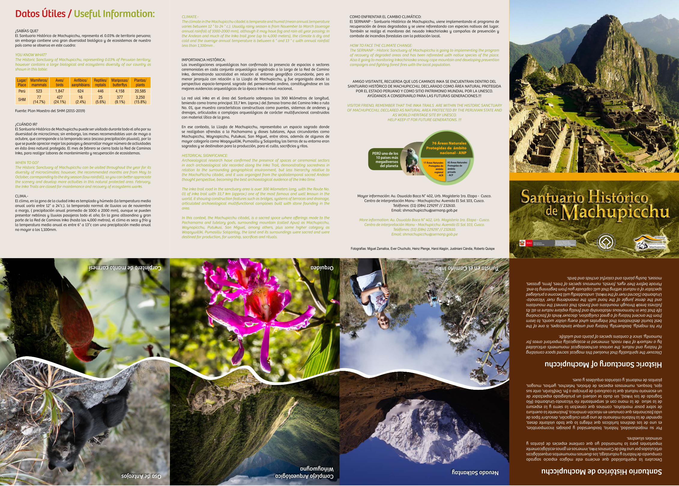
Datos Útiles / Useful Information:¿SABÍAS QUE? El Santuario Histórico de Machupicchu, representa el 0.03% de territorio peruano; sin embargo contiene una gran diversidad biológica y de ecosistemas de nuestro país como se observa en este cuadro:
YOU KNOW WHAT? The Historic Sanctuary of Machupicchu, representing 0.03% of Peruvian territory; however contains a large biological and ecosystems diversity of our country as shown in this table:
Lugar/ Place
Mamíferos/mammals
Aves/ birds
Anfibios/ aanphibians
Reptiles/ reptails
Mariposas/ butterflys
Plantas/plants
Perú 523 1,847 624 446 4,158 20,585
SHM 77 (14.7%)
427 (24.1%)
16 (2.4%)
25 (5.6%)
377 (9.1%)
3,250 (15.8%)
Fuente: Plan Maestro del SHM (2015-2019)
¿CUÁNDO IR? El Santuario Histórico de Machupicchu puede ser visitado durante todo el año por su diversidad de microclimas; sin embargo, los meses recomendables van de mayo a octubre, que corresponde a la temporada seca (escasa precipitación pluvial), por lo que se puede apreciar mejor los paisajes y desarrollar mayor número de actividades en ésta área natural protegida. El mes de febrero se cierra toda la Red de Caminos Inka, para realizar labores de mantenimiento y recuperación de ecosistemas.
WHEN TO GO?The Historic Sanctuary of Machupicchu can be visited throughout the year for its diversity of microclimates; however, the recommended months are from May to October, corresponding to the dry season (low rainfall), so you can better appreciate the scenery and develop more activities in this natural protected area. February, the Inka Trails are closed for maintenance and recovery of ecosystems works.
CLIMA.- El clima, en la zona de la ciudad inka es templado y húmedo (la temperatura media anual varía entre 12° a 24°c.). la temporada normal de lluvias va de noviembre a marzo, ( precipitación anual promedio de 1000 a 2000 mm), aunque se pueden presentar neblinas y lluvias pasajeras todo el año; En la zona altoandina y gran parte de la Red de Caminos Inka (hasta los 4,000 metros), el clima es seco y frío y la temperatura media anual es entre 6° a 13°c con una precipitación media anual no mayor a los 1,100mm.
CLIMATE.-The climate in the Machupicchu citadel is temperate and humid (mean annual temperature varies between 12 ° to 24 ° c.). Usually rainy season is from November to March (average annual rainfall of 1000-2000 mm), although it may have fog and rain all year passing; In the Andean and much of the Inka trail zone (up to 4,000 meters), the climate is dry and cold and the average annual temperature is between 6 ° and 13 ° c with annual rainfall less than 1,100mm .
IMPORTANCIA HISTÓRICA:Las investigaciones arqueológicas han confirmado la presencia de espacios o sectores ceremoniales en cada conjunto arqueológico registrado a lo largo de la Red de Camino Inka, demostrando sacralidad en relación al entorno geográfico circundante, pero en menor jerarquía con relación a la Llaqta de Machupicchu, y fue organizada desde la perspectiva espacio-temporal sagrado del pensamiento andino, constituyéndose en las mejores evidencias arqueológicas de la época Inka a nivel nacional.
La red vial inka en el área del Santuario sobrepasa los 300 kilómetros de longitud, teniendo como tramo principal 33,7 km. (aprox.) del famoso tramo del Camino Inka o ruta No. 01, que muestra características constructivas como puentes, sistemas de andenes y drenajes, articulados a complejos arqueológicos de carácter multifuncional construidos con material lítico de la zona.
En ese contexto, la Llaqta de Machupicchu, representaba un espacio sagrado donde se realizaban ofrendas a la Pachamama y dioses tutelares, Apus circundantes como Machupicchu, Waynapicchu, Putukusi, San Miguel, entre otros, además de algunos de mayor categoría como Waqaywillki, Pumasillu y Salqantay las tierras de su entorno eran sagradas y se destinaban para la producción, para el culto, sacrificios y ritos.
HISTORICAL SIGNIFICANCE:Archaeological research have confirmed the presence of spaces or ceremonial sectors in each archaeological site recorded along the Inka Trail, demonstrating sacredness in relation to the surrounding geographical environment, but less hierarchy relative to the MachuPicchu citadel, and it was organized from the spatiotemporal sacred Andean thought perspective, becoming the best archaeological evidence of the Inka time.
The inka trail road in the sanctuary area is over 300 kilometers long, with the Route No. 01 of inka trail with 33,7 km (approx.) one of the most famous and well known in the world, it showing construction features such as bridges, systems of terraces and drainage, articulated archaeological multifunctional complexes built with stone founding in the area.
In this context, the Machupicchu citadel, is a sacred space where offerings made to the Pachamama and tutelary gods, surrounding mountain (called Apus) as Machupicchu, Waynapicchu, Putukusi, San Miguel, among others, plus some higher category as Waqaywillki, Pumasillu Salqantay, the land and its surroundings were sacred and were destined for production, for worship, sacrifices and rituals.
COMO ENFRENTAR EL CAMBIO CLIMÁTICO:El SERNANP - Santuario Histórico de Machupicchu, viene implementando el programa de recuperación de áreas degradadas y se viene reforestando con especies nativas del lugar. También se realiza el monitoreo del nevado Inkachiriaska y campañas de prevención y combate de incendios forestales con la población local.
HOW TO FACE THE CLIMATE CHANGE:The SERNANP - Historic Sanctuary of Machupicchu is going to implementing the program of recovery of degraded areas and has been reforested with native species of the place. Also it going to monitoring Inkachiriaska snowy cape mountain and developing prevention campaigns and fighting forest fires with the local population.
Santuario Histórico de Machupicchu Descubra la espiritualidad que encierra este mágico espacio sagrado compuesto de historia y naturaleza, los diversos monumentos arqueológicos articulados por una Red de Caminos Inka, inmersos en zonas ecológicamente importantes para la humanidad ya que contiene especies de plantas y animales silvestres.
Por su majestuosidad, historia, biodiversidad y paisajes incomparables, es uno de los destinos turísticos que integra lo que todo visitante desea, aprender de la historia milenaria de una gran civilización, descubrir tipos de vida fascinantes que conviven en relación armónica, finalmente la aventura de sobre pasar montañas, caminos que conectan la sierra y la espesura de la selva de la mano con el serpenteante río Vilcanota-Urubamba (Río Sagrado de los Inkas), sin duda se volverá un privilegiado espectador de un escenario natural que lo cautivará de principio a fin. Desfilarán, ante sus ojos, bosques, numerosas especies de árboles, helechos, yerbas, musgos, plantas de matorral y coloridas orquídeas y aves.
Oso de Anteojos
Carpintero de manto carmesí
Complejo ArqueológicoWiñaywayna
Orquidea
Nevado Salkantay
Turista en el Camino Inka
Historic Sanctuary of MachupicchuDiscover the spirituality that involved this magical sacred space consisting of history and nature, the various archaeological monuments articulated by a network of Inka roads, immersed in ecologically important areas for humanity, since it contains species of plants and wildlife.
For his majesty, biodiversity, history and unique landscapes, is one of the best tourist destinations that integrates what every visitor wants, to learn from the ancient history of a great civilization, discover kinds of fascinating life that live in harmonious relationship and finally explore nature in all its fullness break through mountains and forests that connect the mountains and the dense jungle of the hand with the meandering river Vilcanota-Urubamba (Sacred river of the Inkas), undoubtedly will become a privileged spectator of a natural setting that will captivate you from beginning to end. Parade before their eyes, forests, numerous species of trees, ferns, grasses, mosses, bushy plants and colorful orchids and birds.
AMIGO VISITANTE, RECUERDA QUE LOS CAMINOS INKA SE ENCUENTRAN DENTRO DEL SANTUARIO HISTÓRICO DE MACHUPICCHU, DECLARADO COMO ÁREA NATURAL PROTEGIDA
POR EL ESTADO PERUANO Y COMO SITIO PATRIMONIO MUNDIAL POR LA UNESCO. AYÚDANOS A CONSERVARLO PARA LAS FUTURAS GENERACIONES.!!!
VISITOR FRIEND, REMEMBER THAT THE INKA TRAILS ARE WITHIN THE HISTORIC SANCTUARY OF MACHUPICCHU, DECLARED AS NATURAL AREA PROTECTED BY THE PERUVIAN STATE AND
AS WORLD HERITAGE SITE BY UNESCO. HELP KEEP IT FOR FUTURE GENERATIONS. !!!
Mayor información: Av. Oswaldo Baca N° 402, Urb. Magisterio 1ra. Etapa - Cusco.Centro de interpretación Manu - Machupicchu: Avenida El Sol 103, Cusco.
Teléfonos: (51) (084) 229297 // 232610. Email: [email protected]
More information: Av. Oswaldo Baca N° 402, Urb. Magisterio 1ra. Etapa - Cusco.Centro de interpretación Manu - Machupicchu: Avenida El Sol 103, Cusco.
Teléfonos: (51) (084) 229297 // 232610. Email: [email protected]
Fotografías: Miguel Zamalloa, Ever Chuchullo, Heinz Plenge, Harol Alagón, Justiniani Cándia, Roberto Quispe
76 Áreas Naturales Protegidas de ámbito
nacional - ANPPERÚ uno de los 10 paises más megadiversos
del planeta17 Áreas Naturales
Protegidas de ámbito
regional-ACR
83 Áreas Naturales Protegidas de ámbitoprivado- ACP
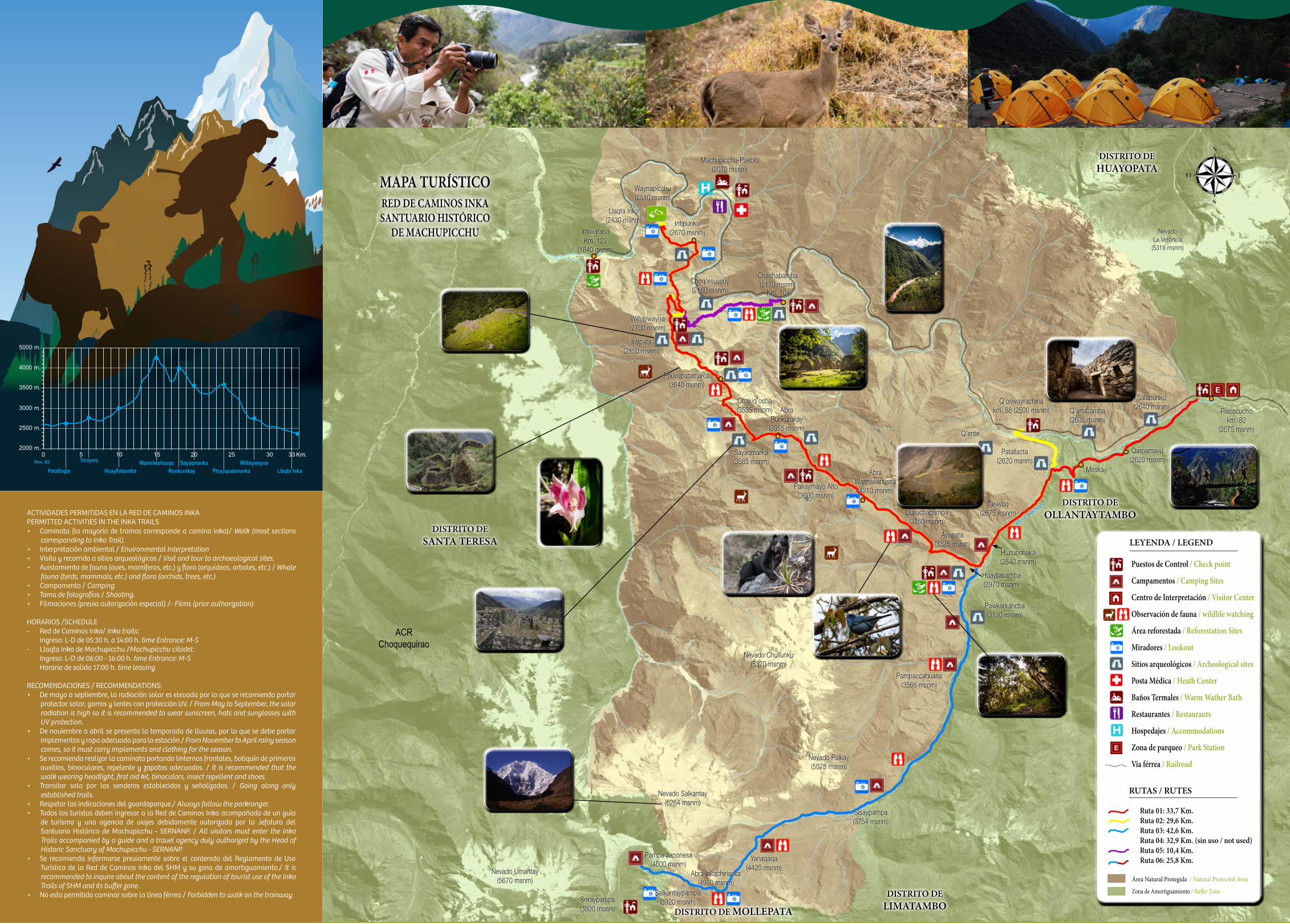
ACTIVIDADES PERMITIDAS EN LA RED DE CAMINOS INKAPERMITTED ACTIVITIES IN THE INKA TRAILS• Caminata (la mayoría de tramos corresponde a camino inka)/ Walk (most sections
corresponding to Inka Trail).• Interpretación ambiental / Environmental Interpretation• Visita y recorrido a sitios arqueológicos / Visit and tour to archaeological sites.• Avistamiento de fauna (aves, mamíferos, etc.) y flora (orquídeas, arboles, etc.) / Whale
fauna (birds, mammals, etc.) and flora (orchids, trees, etc.)• Campamento / Camping• Toma de fotografías / Shooting.• Filmaciones (previa autorización especial) /- Films (prior authorization)
HORARIOS /SCHEDULE- Red de Caminos Inka/ Inka trails: Ingreso: L-D de 05:30 h. a 14:00 h. time Entrance: M-S- Llaqta Inka de Machupicchu /Machupicchu citadel: Ingreso: L-D de 06:00 - 16:00 h. time Entrance: M-S Horario de salida 17:00 h. time leaving
RECOMENDACIONES / RECOMMENDATIONS:• De mayo a septiembre, la radiación solar es elevada por lo que se recomienda portar
protector solar, gorros y lentes con protección UV. / From May to September, the solar radiation is high so it is recommended to wear sunscreen, hats and sunglasses with UV protection.
• De noviembre a abril se presenta la temporada de lluvias, por lo que se debe portar implementos y ropa adecuada para la estación / From November to April rainy season comes, so it must carry implements and clothing for the season.
• Se recomienda realizar la caminata portando linternas frontales, botiquín de primeros auxilios, binoculares, repelente y zapatos adecuados. / It is recommended that the walk wearing headlight, first aid kit, binoculars, insect repellent and shoes.
• Transitar solo por los senderos establecidos y señalizados. / Going along only established trails.
• Respetar las indicaciones del guardaparque./ Always follow the parkranger.• Todos los turistas deben ingresar a la Red de Caminos Inka acompañado de un guía
de turismo y una agencia de viajes debidamente autorizada por la Jefatura del Santuario Histórico de Machupicchu - SERNANP. / All visitors must enter the Inka Trails accompanied by a guide and a travel agency duly authorized by the Head of Historic Sanctuary of Machupicchu - SERNANP.
• Se recomienda informarse previamente sobre el contenido del Reglamento de Uso Turístico de la Red de Caminos Inka del SHM y su zona de amortiguamiento./ It is recommended to inquire about the content of the regulation of tourist use of the Inka Trails of SHM and its buffer zone.
• No esta permitido caminar sobre la línea férrea / Forbidden to walk on the trainway
NevadoLa Verónica
(5319 msnm)
Piscacuchokm. 82
(2675 msnm)
Salapunku(2640 msnm)
Qarpamayu(2620 msnm)
Q’anabamba(2605 msnm)
Meskay
Patallacta(2620 msnm)
Q’oriwayrachinakm. 88 (2500 msnm)
Q’ente
Tarayoq(2675 msnm)
H’atunchaka(2840 msnm)
Llulluchapampa(3760 msnm)
AbraWarmiwañusca(4210 msnm)
AbraRunkurakay
(3955 msnm)
Pakaymayo Alto(3600 msnm)
Sayaqmarka(3585 msnm)
Chakiq’ocha(3535 msnm)
Phuyupatamarca(3640 msnm)
Chachabamba (2170 msnm)
Km. 104
Waynapicchu(2510 msnm)
Llaqta Inka(2430 msnm)
Machupicchu-Pueblo(2070 msnm)
Wiñaywayna(2700 msnm)
Choq’esuysuy(2160 msnm)
Intipata(2850 msnm)
Intipunku(2670 msnm)Intiwatana
Km. 122(1840 msnm)
Ayapata(3328 msnm)
Huayllabamba(2970 msnm)
Pawkarkancha(3130 msnm)
Pampaccahuana(3566 msnm)
Nevado Chullunku(5370 msnm)
Nevado Palkay(5075 msnm)
Sisaypampa(3754 msnm)
Yanaqaqa(4420 msnm)
Abra Inkachiriaska(4930 msnm)
Pampa Japonesa(4600 msnm)
Nevado Salkantay(6264 msnm)
Soraypampa(3800 msnm)
Salkantaypampa(3920 msnm)
Nevado Umantay(5670 msnm)
Río Cusichaca
DISTRITO DEHUAYOPATA
DISTRITO DEOLLANTAYTAMBO
DISTRITO DELIMATAMBODISTRITO DE MOLLEPATA
DISTRITO DESANTA TERESA
ACRChoquequirao
LEYENDA / LEGEND
RUTAS / RUTES
Puestos de Control / Check point
Campamentos / Camping Sites
Centro de Interpretación / Visitor Center
Observación de fauna / wildlife watching
Área reforestada / Reforestation Sites
Miradores / Lookout
Sitios arqueológicos / Archeological sites
Posta Médica / Heath Center
Baños Termales / Warm Wather Bath
Restaurantes / Restaurants
Hospedajes / Accommodations
Zona de parqueo / Park Station
Vía férrea / Railroad
Ruta 01: 33,7 Km. Ruta 02: 29,6 Km.Ruta 03: 42,6 Km.Ruta 04: 32,9 Km. (sin uso / not used)Ruta 05: 10,4 Km.Ruta 06: 25,8 Km.
Área Natural Protegida / Natural Protected Area
Zona de Amortiguamiento / Buffer Zone
MAPA TURÍSTICORED DE CAMINOS INKASANTUARIO HISTÓRICO
DE MACHUPICCHU