Embed Size (px)
Citation preview
!.
!.
!.
!.
!.
!.
!.
!.
!.
!.
!.
!.
!.
!.
!.
!.
!.
!.
!.
!.
!.
!.
!.
!.
!.
!.
!.
!.!.
!.
!.
!.
!.
!.
!.
!.
!.
!.
!.
!.
!.
!.
!.
!.
!.
!.
!.
!.
!.
!.
!.
!.
!.
!.
!.
!.
!.!.
!.
!.
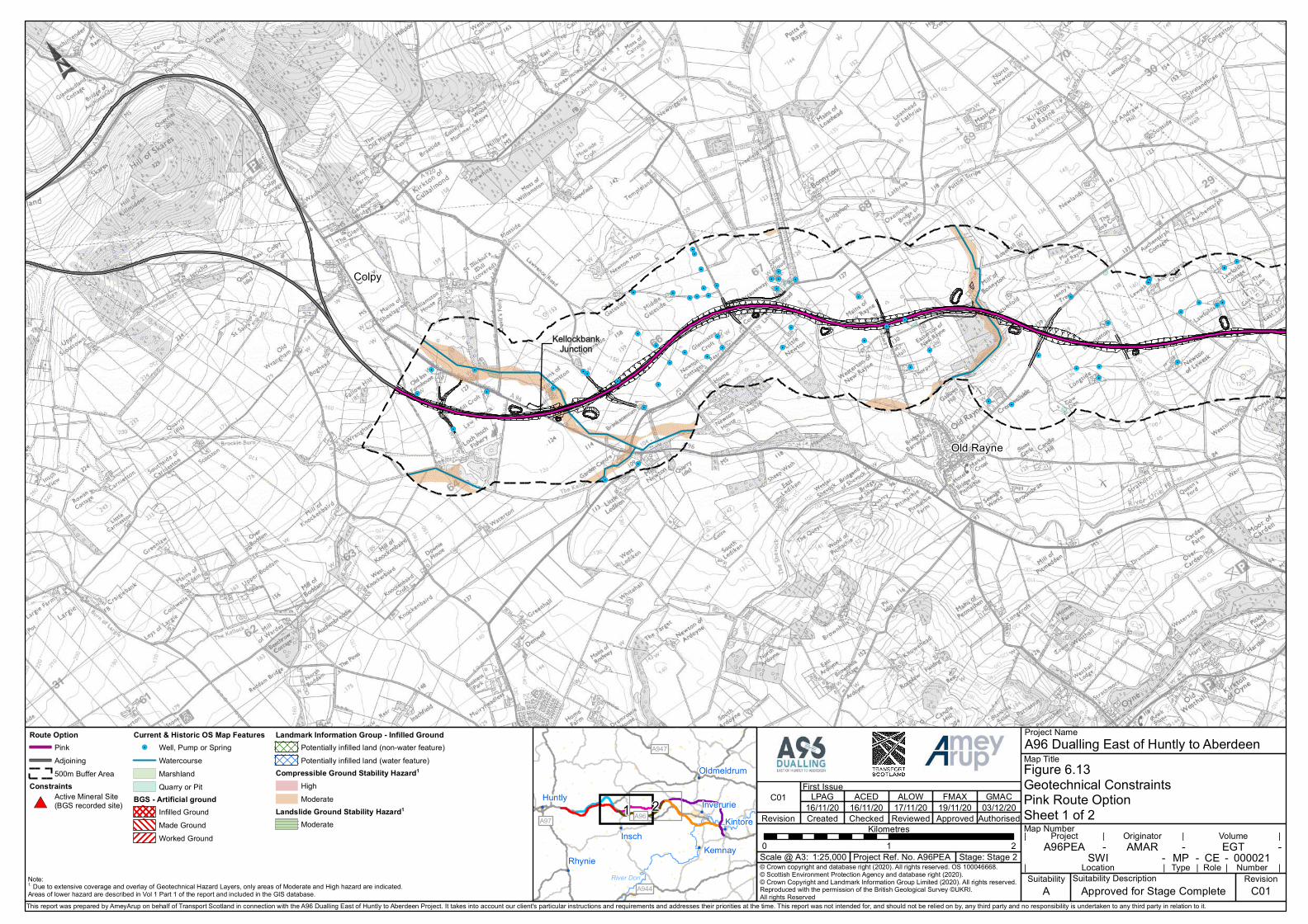
KellockbankJunction
Old Rayne
Colpy
© Crown copyright and database right (2020). All rights reserved. OS 100046668.© Scottish Environment Protection Agency and database right (2020).© Crown Copyright and Landmark Information Group Limited (2020). All rights reserved.Reproduced with the permission of the British Geological Survey ©UKRI. All rights Reserved
0 1 2Kilometres
Route OptionPinkAdjoining500m Buffer Area
Constraints
#*Active Mineral Site(BGS recorded site)
Current & Historic OS Map Features!. Well, Pump or Spring
WatercourseMarshlandQuarry or Pit
BGS - Artificial groundInfilled GroundMade GroundWorked Ground
Landmark Information Group - Infilled GroundPotentially infilled land (non-water feature)Potentially infilled land (water feature)
Compressible Ground Stability Hazard1
HighModerate
Landslide Ground Stability Hazard1
Moderate
A96PEAMap Number
!(
!(
!(
!(
!(
!(
!(
River Don
1 2
A947
A944
A97 A96
Kemnay
Kintore
Rhynie
Huntly
Oldmeldrum
Inverurie
InschProject Ref. No. A96PEA
Suitability DescriptionApproved for Stage Complete
Stage: Stage 2AMAR EGT
SWI MP 000021CELocation Type Role Number
Project Originator Volume
Figure 6.13Geotechnical ConstraintsPink Route OptionSheet 1 of 2
A96 Dualling East of Huntly to AberdeenProject Name
Map Title
First Issue
Revision
C01
Created
LPAG16/11/20
Checked
ACED16/11/20
Reviewed
ALOW17/11/20
Approved
FMAX19/11/20
Authorised
GMAC
1:25,000Scale @ A3:- - -
- - -| | | |
| | | | |Suitability
ARevision
C01Note:1. Due to extensive coverage and overlay of Geotechnical Hazard Layers, only areas of Moderate and High hazard are indicated.Areas of lower hazard are described in Vol 1 Part 1 of the report and included in the GIS database.This report was prepared by AmeyArup on behalf of Transport Scotland in connection with the A96 Dualling East of Huntly to Aberdeen Project. It takes into account our client's particular instructions and requirements and addresses their priorities at the time. This report was not intended for, and should not be relied on by, any third party and no responsibility is undertaken to any third party in relation to it.
03/12/20

!.
!.
!.
!.
!.
!.
!.
!.
!.
!.
!.
!.
!.
!.
!.
!.
!.
!.
!.
!.
!.!.
!.
!.
!.
!.
!.
!.
!.
!.
!.
!.
!.
!.
!.
!.
!.
!.
!.
!.
!.
!.
!.
!.
!.
!.
!.
!.
!.
!.
!.
!.
Old Rayne
Durno
Whiteford
Daviot
Pitcaple
© Crown copyright and database right (2020). All rights reserved. OS 100046668.© Scottish Environment Protection Agency and database right (2020).© Crown Copyright and Landmark Information Group Limited (2020). All rights reserved.Reproduced with the permission of the British Geological Survey ©UKRI. All rights Reserved
0 1 2Kilometres
Route OptionPinkAdjoining500m Buffer Area
Constraints
#*Active Mineral Site(BGS recorded site)
Current & Historic OS Map Features!. Well, Pump or Spring
WatercourseMarshlandQuarry or Pit
BGS - Artificial groundInfilled GroundMade GroundWorked Ground
Landmark Information Group - Infilled GroundPotentially infilled land (non-water feature)Potentially infilled land (water feature)
Compressible Ground Stability Hazard1
HighModerate
Landslide Ground Stability Hazard1
Moderate
A96PEAMap Number
!(
!(
!(
!(
!(
!(
!(
River Don
1 2
A947
A944
A97 A96
Kemnay
Kintore
Rhynie
Huntly
Oldmeldrum
Inverurie
InschProject Ref. No. A96PEA
Suitability DescriptionApproved for Stage Complete
Stage: Stage 2AMAR EGT
SWI MP 000022CELocation Type Role Number
Project Originator Volume
Figure 6.14Geotechnical ConstraintsPink Route OptionSheet 2 of 2
A96 Dualling East of Huntly to AberdeenProject Name
Map Title
First Issue
Revision
C01
Created
LPAG16/11/20
Checked
ACED16/11/20
Reviewed
ALOW17/11/20
Approved
FMAX19/11/20
Authorised
GMAC
1:25,000Scale @ A3:- - -
- - -| | | |
| | | | |Suitability
ARevision
C01Note:1. Due to extensive coverage and overlay of Geotechnical Hazard Layers, only areas of Moderate and High hazard are indicated.Areas of lower hazard are described in Vol 1 Part 1 of the report and included in the GIS database.This report was prepared by AmeyArup on behalf of Transport Scotland in connection with the A96 Dualling East of Huntly to Aberdeen Project. It takes into account our client's particular instructions and requirements and addresses their priorities at the time. This report was not intended for, and should not be relied on by, any third party and no responsibility is undertaken to any third party in relation to it.
03/12/20

!.!.
!.
!.
!.!.
!.
!. !.
!.!.
!.!.
!.
!.
!.
!.
!.
!.
!.
!.
!.
!.
!.
!.
!.
!.
!.
!.
!.!.!.
!.
!.
!.
KellockbankJunction
CardenJunction
Old Rayne
Colpy
© Crown copyright and database right (2020). All rights reserved. OS 100046668.© Scottish Environment Protection Agency and database right (2020).© Crown Copyright and Landmark Information Group Limited (2020). All rights reserved.Reproduced with the permission of the British Geological Survey ©UKRI. All rights Reserved
0 1 2Kilometres
Route OptionBrownAdjoining500m Buffer Area
Constraints
#*Active Mineral Site(BGS recorded site)
Current & Historic OS Map Features!. Well, Pump or Spring
WatercourseMarshlandQuarry or Pit
BGS - Artificial groundInfilled GroundMade GroundWorked Ground
Landmark Information Group - Infilled GroundPotentially infilled land (non-water feature)Potentially infilled land (water feature)
Compressible Ground Stability Hazard1
HighModerate
Landslide Ground Stability Hazard1
Moderate
A96PEAMap Number
!(
!(
!(
!(
!(
!(
!(
River Don
1 2
A947
A944
A96
A97
Kemnay
Kintore
Rhynie
Huntly
Oldmeldrum
Inverurie
InschProject Ref. No. A96PEA
Suitability DescriptionApproved for Stage Complete
Stage: Stage 2AMAR EGT
SWI MP 000023CELocation Type Role Number
Project Originator Volume
Figure 6.15Geotechnical ConstraintsBrown Route OptionSheet 1 of 2
A96 Dualling East of Huntly to AberdeenProject Name
Map Title
First Issue
Revision
C01
Created
LPAG16/11/20
Checked
ACED16/11/20
Reviewed
ALOW17/11/20
Approved
FMAX19/11/20
Authorised
GMAC
1:25,000Scale @ A3:- - -
- - -| | | |
| | | | |Suitability
ARevision
C01Note:1. Due to extensive coverage and overlay of Geotechnical Hazard Layers, only areas of Moderate and High hazard are indicated.Areas of lower hazard are described in Vol 1 Part 1 of the report and included in the GIS database.This report was prepared by AmeyArup on behalf of Transport Scotland in connection with the A96 Dualling East of Huntly to Aberdeen Project. It takes into account our client's particular instructions and requirements and addresses their priorities at the time. This report was not intended for, and should not be relied on by, any third party and no responsibility is undertaken to any third party in relation to it.
03/12/20

!.
!.
!.
!.
!.
!.
!.
!.
!.
!.
!.
!.
!.
!.
!.
!.
!.
!.
!.
!.
!.
!.
!.
!.
!.
!.
!.
!.
!.
!.
!.
!.
!.
!.
!.
!. !.
!.
!.
!.
!.
CardenJunction
Old Rayne
Durno
Whiteford
Pitcaple
© Crown copyright and database right (2020). All rights reserved. OS 100046668.© Scottish Environment Protection Agency and database right (2020).© Crown Copyright and Landmark Information Group Limited (2020). All rights reserved.Reproduced with the permission of the British Geological Survey ©UKRI. All rights Reserved
0 1 2Kilometres
Route OptionBrownAdjoining500m Buffer Area
Constraints
#*Active Mineral Site(BGS recorded site)
Current & Historic OS Map Features!. Well, Pump or Spring
WatercourseMarshlandQuarry or Pit
BGS - Artificial groundInfilled GroundMade GroundWorked Ground
Landmark Information Group - Infilled GroundPotentially infilled land (non-water feature)Potentially infilled land (water feature)
Compressible Ground Stability Hazard1
HighModerate
Landslide Ground Stability Hazard1
Moderate
A96PEAMap Number
!(
!(
!(
!(
!(
!(
!(
River Don
1 2
A947
A944
A96
A97
Kemnay
Kintore
Rhynie
Huntly
Oldmeldrum
Inverurie
InschProject Ref. No. A96PEA
Suitability DescriptionApproved for Stage Complete
Stage: Stage 2AMAR EGT
SWI MP 000024CELocation Type Role Number
Project Originator Volume
Figure 6.16Geotechnical ConstraintsBrown Route OptionSheet 2 of 2
A96 Dualling East of Huntly to AberdeenProject Name
Map Title
First Issue
Revision
C01
Created
LPAG16/11/20
Checked
ACED16/11/20
Reviewed
ALOW17/11/20
Approved
FMAX19/11/20
Authorised
GMAC
1:25,000Scale @ A3:- - -
- - -| | | |
| | | | |Suitability
ARevision
C01Note:1. Due to extensive coverage and overlay of Geotechnical Hazard Layers, only areas of Moderate and High hazard are indicated.Areas of lower hazard are described in Vol 1 Part 1 of the report and included in the GIS database.This report was prepared by AmeyArup on behalf of Transport Scotland in connection with the A96 Dualling East of Huntly to Aberdeen Project. It takes into account our client's particular instructions and requirements and addresses their priorities at the time. This report was not intended for, and should not be relied on by, any third party and no responsibility is undertaken to any third party in relation to it.
03/12/20


![Federation House, Airds & Co Limited Telephone: 0131 332 ...airdsandco.co.uk/ESW/Files/15_Daviot_Road[1].pdf15 Daviot Road, Dunfermline, KY12 7LY Offers Around £150,000. VIEWINGS](https://img.pdfslide.net/doc/110x75/60082546f3c822136438688a/federation-house-airds-co-limited-telephone-0131-332-1pdf-15-daviot.jpg)


![201[ ] No. ROADS AND BRIDGES - transport.gov.scot · (b) O.J. L 26, 28.1.2012, p.1. Directive 2011/92/EU repealed and recast the provisions contained in Council Directive Directive](https://img.pdfslide.net/doc/110x75/5d0a25c288c99337148b6240/201-no-roads-and-bridges-b-oj-l-26-2812012-p1-directive-201192eu.jpg)