Embed Size (px)
Citation preview

••"5r
Diamond Dri!l ; ng 4U07NE91I7 ee28Ai GUNTERMAN 010
Township of GUNTERMAN(Formerly Twp.149)
Report NQ: 32
Work performed by: The Stanward Corp. 6 Stanrock Uranium
Claim NQ Hole N9 Fooiage Date Note
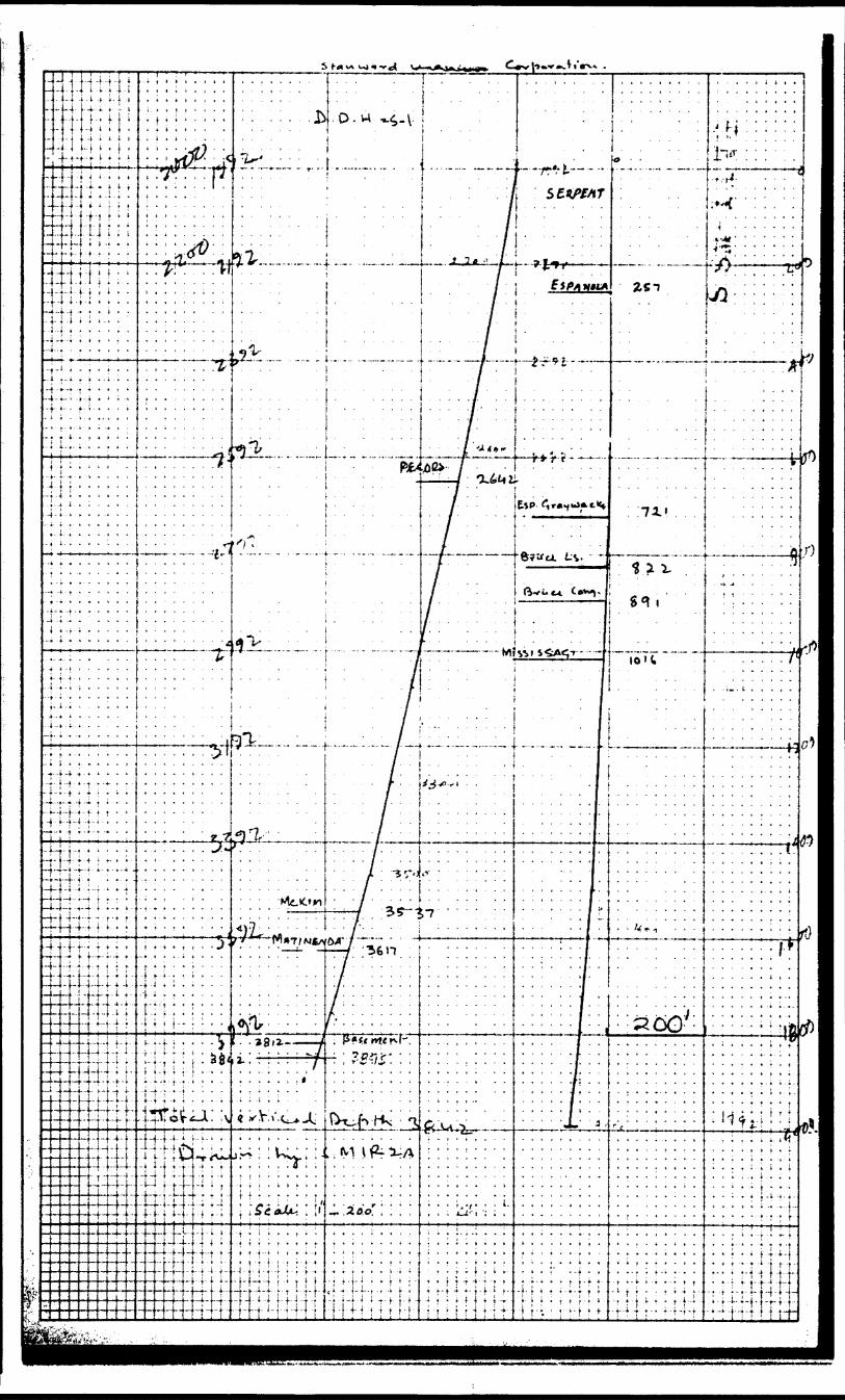
S 126000 S-l 3895.0' Mar/66
Notes;
AWL 004(7 fe'Jlruv '.i J "2

720:
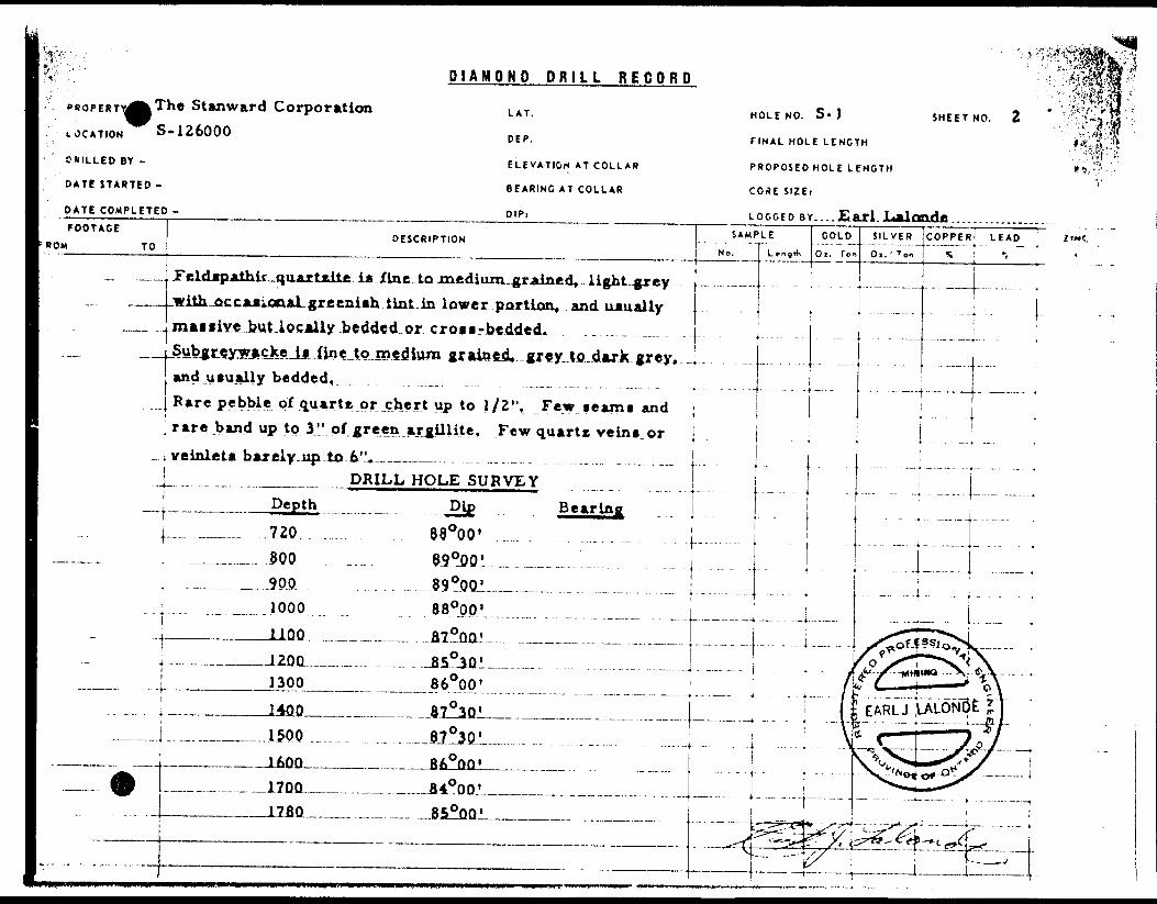
DIAMOND DRILL RECORDPROPERTY. Tha Stanward Corporation .
SHOT NOMMII.........,...,,..!,..... . ...............................SKTION MOM
UTITOOI................................................................ ....... .DATUM .........,
DfWUttUW.............................,........ ... ..,, ............ .. ... BEAIINO. .
.................. ...,. .. . . .. ......... ...DIP... ., .
TO
.90'
HOLE No. S-l
STAIIEO
COMPUTED
ULTIMATE DEPTH
PROPOSED DEPTH
otPTM rerr
0-10
10-257 "
.257. S.46
^•——— ••i li..*
464-721
FORMATION
Cislpg
S*rp*n* O'fn'tr.itff. M*dlum tn fln^ gr^
4 Eipanola. Interbedded, grey* fine, g
• Ut and l{rp*rtC*ie, Ai 257, ^ the fi ri
RAj9jft*in VkAf^oonnMiA WMi^K nrm**4l nVnrlmtfl
At 373 iltimr brtcria Alto m*, 355.•p^rlcl^f^ grit.
At 4M . B&ae of 6' band of medium |
t n i ••^a^ VkAV^jl
Fip9 flraift^^i v^llowiff}^ bTow^ lioi^v
SAMPLE NO.
lined* j
rained '
M^f**i
than ff
}59 Atl
XAiafisL
t lltftr-i
FROM
ray to ^
Martfitm Ate r
rincrlY
* OC P J
brown;
t e ivith
TO
irhitc qv
Lfflij^J
LaLojLh;
4inri ]B
fliniriAl
oh. cri
tv^^p ffi*!
WIDTH
arixit U-witLQSOU
0^*1}'
Iftflds
t, Th
|t PT ^
*s~- J
ASSAV VALUES
E,- Loc
a^Jtewr
oior ap
r di* tor
of ined'
la app*
fkflDA \ 1
ally we
iih to L
pear B.
tetL- .
um gr a
liri) to b
iterhedi
1 beddc
lack.
laed*^
e the
t
d.
MOKTHCKN M IHt* PO*M 101 "fv7*4
M1UCO IT—— .IIGMIO., \ V
.-U \-V -' K X \
A C Q r- c. o r ;-.- r: 7 v * *" j 57 E- -* i? O u. -- '.-' .. i i- i . ; .' -- \.J l\i
y ' ; .
pROPERTY^^The Stanward Corporation LOCATION S-126000CHILLED BY -
DATE STARTED -
DIAMOND DRILL RECORD
LAT.
DEP.
ELEVATION AT COLLAR
BEARING AT COLLAR
MOLE NO. S- J
FINAL HOLE LENGTH
PROPOSED HOLE LENGTH
COSE SIZEi
JLalonde
SHEET NO.
FOOTAGEDESCRIPTION BOM TO
— __ . FeldapAlhic-quarttite ia Jfine to medium. grained, ,J.ight.^jrey . -..., with occational greeniflh tint in lower portion, and uaually
SAMPLE
•— --
_ . maiflive l?ut locally bedded or croii-beddcd. . .. ............. . j .— __ |JubjLiLey^acJceJjLiine,tQ,mediurn graioe.cl ,gr*y,.to.darX^grey, 4
j and usually bedded,j Rare pebble of quartz or chert up to 1/2". Few seami and; rare band up to 3" of green argillite. Few quartz ve in i orv*inl*tp h*r*ly up to 6".
| DRILL HOLE SURVEYDepth Dip Bearing
.j— - - .7ZO. . . 8.8 00.0.' ....... . . .......... . . . .....^.800 ^ . . 89 0OD1. .
-
----
' ' ' " - -
! 1000 88000' 1
-
Ox. Ton
i 1100 B7 0QQ' 1 i i
SILVER COPPER LEAD ' Oi. ' Ton S "i
--ri--:. ..... . . - .,..* -.,. . ... ^ j.. -, .. ..... .
.... .. ....... .....|............. . .j- — — ....... .'"'.:.'j:zr.'.'.-.'
. ....i ...L..... .^^rtssi^^i
o ' \/ ? ^^•"•*^. *t \*. j— -.IZDQ.. , ^ J5 JQ 1 . .. ...... .......... .. ....^..... .j . /,?X7..-^v^\1300 86000' i 7
l 1400 87 03Q' . .. . 1 i
-. - J....... . ...1500 ................. . - 81^30.' ........ . .. .............j 1600 86000'
^ 1 17QO fi40nn'1780 850OQ'
i
\
——— -- |----{———— - -
^^^-••^
,... 'r ^
——————— -^
i^y^ l
?~r-™r~"2i-i:\ -- -iu L j Ci \l E ARLJ VALO'NbE JJ* c — r~~""7oy^s^o4o*o^X —— !
^"*- 4 in **^•---r-- '----t'--^/^t x' "" "
^^^-c^d^ j
i t" '. . .-j —— .. —— , . ^ —— r..

^;- ..~-v r ——————————DIAMOND DRILL RECORD
' PROPERTY - The Stanward Corporation LAT.LOCATION S- 126000 D IP.
•'i D RILLED BY - ELEVATION AT COLL AR
DATE STARTED -M STCh 3, 1966 BEARING AT COLLAR
DATE COMPLETED - March 17, 1966 DIP:FOOTAGE
FROM TO
721,0-823.9
^
;v f *823. 9-893. 0
M"'.893.0-1018.8
1018.8-1801.0
DESCRIPTION
Espanola Formation. Calcareous greywacke with interbeddedintraformational breccia and minor siltstone and grit.Greywacke is fine to medium grained, grey and usuallyslightly calcareous. Few fragments of siltstone from
•v^yii
HOLE NO. S-l SHEET NO. 1
FINAL HOLE LENGTH 1801.0 FT.
PROPOSED HOLE LENGTH FT.
CORt SUE:
LOGGED BY... EArl..L.Alande ..............SAMPLE
No.
799. 5 to 823.9.
Intraformational breccia is composed of angular fragmentsof siltstone in a medium grained, grey, calcareous greywackematrix. A 3/4" pebble of granite.Espanola Formation. Bruce limestone is composed of inter bedded limestone and siltstone. 823.9-861.0 predominatelysiltstone with the portion of limestone increasing with depth.861.0-893.0 predominately limestone with portion of siltstoneIncreasing in the lower few feet of section. Limestone is
very fine to fine grained, light to medium buff, grey to lightgrey and finely laminated. Siltstone is very fine grained,dark Ivory to buff, and finely laminated.Bruce Formation. Polymictic conglomerate. Polymicticconglomerate is composed of sparse sub-angular to roundedpebbles, cobbles add boulders of quartz granite and granitegneiss in a dark grey to dark greenish-grey, medium grainedgreywacke matrix which may carry a few specks of pyrite.Upper Mississagi Formation. Feldspathic quartzite with.. ,some interbedded gJbgreywacke.
J L L' I'l "i i'""L rTiLTfilUill'lliritUlU LiiiliiiiiiiuiiL
— . ——— --
L eogtti
f -
u-— 1
.
...... jv- T J* "
ccot" -- — —— - J
GOLDOi.'To"
-
- -
.
.T. TO
E- OFf .OCtS-
5ATJL7
SILVER COPPER LEAD 7INCOl.-'Ton "i 'i \- . .. .... j.. ..-...... . i . -. . .I...-..|......,....J...... ..i
.........- .. .. ... . ... - 4 . .... .i.,, . ... .
| .
' ! !
. . ..p... .. ,. . . ,i.. .... ., ... .... .4- - . ..-
BE REMOVED F.RQM
JCC OF4 THE-RESIDEKZ.
Y ONT.-OEPTV OF-MJJNES
r STE. ;MARIC, ONTf
, i ^ il [1
.....- . -. t
r^- -j^"T' : " ' i
Mr- ---;-u4 — -i- ri|K C. :M J - -i f li t.L '... ... i i ! ''.i T~" 5Artrr'srr."f'''.7;E - t ' " " '
i , —1. ... - . .j. . . .

; ; .^ROP.ERTY stanroc*
TOTAL DEPTH
LOCATION
LOGGED BY
DATE BEGUN
TESTSUranium wine-s Ltd. 1 QnA2100
CO-ORDINATES COLLAR 2300Twp. 149 LAT. 400 'S DEP. 30'W 2500
tL^LftlOct. 2
Qnjlfi ELEVATION of #1-8126000 ^900
n/ftQ AZIMUTH 000*00' llOft
DATE FINISHED ANGLE -90 0 QQ'
FOOTAGE
1801.0-2146.0
•V "
2146.0-2200.3
22OO. 2-2204. 3
1 2 204. 3-2228. 7
2228.7*2600.0 .
I.GTH.
34&.0
S4 T 2
4.1
. .24^4
-371. i
DESCRIPTION
fold, qtzite. i,t gr to gr, lof/ally dk gr or si.....sniah. tint. F to Died gd. faaa to bed. ram x-bed.
Odd qtz peh and rare up to 1" wide qtz pab band.FQW p pack a of py. ndd fract; ? ft|ne of which ar*qtz filled OY have rusty faces in up portion of**H""t . R ft r* aejtm Jty-ni 1 m*f-
Feld. qtr.itA^-Dk. -ijr..to -gr., raraly It cjr. Mud ^d,locally f ojr cat. gd T KA8A t n h^d , Q t\c\ p^attered cpeb. Rare speck py. Few frjct^
Di abase,. Aphanitic text, aruiah bk. yaw str^oo^rb *nd or qt * , yp flnd lo\' coni at 30 C to coreaxis .Poly, cgl, Vfiry sparap t,O nM"**rQus i^i Jow^j- 2 ftfraga y peb a, *i"-l*s" dlam of qtx *nd grangein a roed, yd. dk gr qtzite matrix. Sect Igely anod qd. dX gr qtzite. odd speck of py,
jpaid, qtzitiA T Lt gr, locally gni*h yr or gr tp to ioo*lly m#td gd , M*** t n b*jd ral*ely X— betlOdd ae am argil mat. F*w fr*ot aomo of which are
at- f F llla/4 fl*^^ or^&^v rvui*-* ****ww. ^*w vpwwK t*y ,
\
82"3C'Bo 0 ao7 8 "30' 77*30' 77*00' 77*00'
s;, M P . ff
J*^s *A/I
~-~4^hi
0
iii
ajCD
" t?
f |2 j:
/^V ^^ss^
i;
•i
i ctss.
L J-
^
*-*S-
K W
co u. w o
:: a. ;3 :
; ~^ ^ir — O" ~*~
f- *- i' -J
-f -4o/^-f/v x^
yffi-bfa" \-f\ ^"V'v
^ -** — -^n y? X r
t — . ——
tir?
o ^ u - /gj?^ ' —— ' /— -~c jr--
WIN'^U — ̂
^ *^^^^ *\c t of ^^
^4
f-
~*t**
mm m ———1
MM .•••a
——
g•"""
HsO)t-4
z-3
3:3
^
^J
V~1"y J
7
f/*"/ t&S&/
T*™
i C?oi•.ja j;
-5-5 —UJ
y.
OD "^O
^H H
i b!;S JLO w/*" t/)— i?

•**
"' .PROPERTY Stanrock Uranium Mines Limited
TOTAL DEPTH LOCATION LOGGED BY
DATE BEGUN
CO-ORDINATES COLLAR
Twp. 149 LAT. 400. 's DEP. 3Q'w
E. Lalonde ELEVATION of #i-si26000OCt 20/69 AZIMUTH OuO'ftn'
DATE FINISHED ANGLE -90*00*
FOOTAGE
2660-n-5Afel f
f 2661.0-2791.0
" 2791.0-2901 .0
-
2901.0-2927.0
2927.0-3088.2
3088 2—3152 O
LGTH.
i ] .0
130.0
no. o
^6.0
161.2
63 B '
1900 2100 2300 2500 2700 2900 3100 3300 3500
TESTS
DESCRIPTION
F*)r}-qtzitft . T.t gr, loyally gni ah ^r or g r . P to
loyally rued 9 d. Mass tn hrvi, rnr*. ly -r-b^d , ^'.rt
HAsiin argil, mat. Kev frar-t sinm* nf whi.-h AT*' (t?
filled- Odd a pock py.Interbedded argillite and qt?,Uc Arcu.1 ia v .f .
i s i 'jd. It' yr *" rt O''* HI fi if B HHTtnf la gwke . Few f ract some of which
™,-i ^U Hare gtz
m flfilled.
Argil 11 t-rt with Kncnft narrow i nt r-rhnririftd qr.zir.a
/,r-.jil is v f yd, yr to dV y,r 4 and f laminated or
Ot^Xtfl JL** f tQ rnad yd, roast; LO bed. It ur to ur s
may yradc to a ywke . Fuw fract ^interbedded qtzite, gwke ai)i sorot
l rare apeck ol . ̂ a irgi-L,. . Qtzl^t
ia f to med jd f It gr to jr, ran se to bedto a gwke. .Argil is. v.. I.. yd, yx, to OX urlaminated or bed. Rare Bi^cX pyArgillite with 8pma garrow intjeriAri/il is v f gd, yr to d^ yr ar*d0^-*, ?nH q*- 7 i** 4* rft f ri ar.rl .r
aud. aiayaiiii^ fjjitt
! ew f r ac t.
^fiiL-fl-tiilil nt'lytrj It jr
e or .iv*lgmin.a.te
— ir^r^diMB. qteite with aowc narrow ban^a oircjil- envi —
— and may grade — te a gWhe i — frrgii — i-e— dk — gr — to--fek —— — v S. gd and finely bed or laminated ——
82"30' 80 C 30' 78*30' 77 f 30'77 '00' 77 '00''
77*00'SAMP. t
i
fr,
hud .nl
y .. ...M ..
gradelit-. ......
L*
ci or be-
^ f
^HSHEET 1
HOLE NO. S-i
iSM-
-
^
-
2i^..QjE
— .... —— ...
. ^--
(/^'
/ff
h^S^
il
-IS-Jlnj
py -r^^
fp ?-i.. : .-.r- flnJ
Jrn|t — i
" —— ̂ v,'""-L
/I.N'fM \
1 LAL'^'
7 S
si-p1N^ ^*
r13* — i
\
- ^^^-31-
0)
3 r-5 o x
Uui
S sUJ 0PSenUl
**i.

^•' " . , .PHOP,ERTY ftl-,n™^Vt
TOTAL DEPTH
f s ' ' ' , X" TESTSminium MlnAo r.*M4*-**4 A ^-'
3895 CO-ORDINATES COLLAR 3700
LOCATION TWO. 149 LAT . 400* fi DEP. ifl'w
LOGGED BY R
DATE BEGUNT 7^1i^vta ELEVATION Of #1-8126000
Oct 20/69 AZIMUTH 000*00'
DATE FINISHED Fab 7/70 ANGLE -90*00'
FOOTAGE
3088.2-3152
. 3152-3311.5
- *-
331^.5-3514.5
.
LGTH.
.- *
X'' V*
, t -
DESCRIPTION
PradO* qtzita with aome bands of aryil and gwXa.
Qttit* ia it. vr to gr, find gd, ma a a to bd. andnay grade to a gwXa. Argil is v.f. gd ( dx. tjc
tract And rare qtx vain.Interbed argil and qtzita **ilcS pay locally grad^
to a gwXe. Argil * qtz liXa abova aact 3088.2-3152; 3222.4-3225.3 lamprophyre, p. gd, *aaa bX.
3235.0-3235.5 La*prophyra f liXc abov*3241.1-3242.13295.1-3297.6
r*v fract.Pradoa qtzite with a faw narrow bands of argil.Otxite ia f. gd. It. gr to gr. mass to barVdad andatay grada to a gwXa. Argil ia v.f. ^Jl, dX gr tobX ^nd finttly haddjftd Or Iflioiniltfid. *~
3322.9-3323.0 I Jim p3323.6-3323.8 Lamp.
3332.2-3332.3
3337.4-3337.73343.9-3344.6 - QM
3485 .0-3485. B - ^ D i"
74"
SAMP. #
4^JL"*"~ 7ft
'KjinSHEET 1
HOLE NO. *-l
t "1
l ———— J^^~
^r-*ra-IHHJ
r" ^
LJL^.
IntD
^ 1jj
n- Jf-
^ S^ * Q
en—— brf-
LJ
3j*
in

- ',. PROPERTYSHEET NO. 2
Mlnaa Lin!tad HOLE: NO. ,
FOOTAGE LGTH. I NSCRIPTION
3S14.S-3579.9 /^^lntarb*d^qt*it**. argil *nd gwka. Q t rita ±m^±o d]L-0r^ fflaaJU to Joed jmd.may grada. to -a -o*nc*. .- ATOXX - i
L*..4td*—dX-.gr .to JA-and-finaly lamina tad or badded*-^r av. fract' a.
1*5— ..^— -Argil*-V* T-.^go*-gr.^iQDX and.fin*ly Iftmiruitid cr
.3S9fl.S-3612.fiL-^ __. -Q*kaL.-,r,..-Std.. jfir vith *1 anift^ tj,nlj..W*aaivt^to .ba.dd,Odd frag of
3612.8-3628.3_^.___ Argil. V. f ,
fract, jrfiih aoma. -qtx B. Fine gd. i
and3t?.-AD.d* or carb fillad,
3643*4-3672*3____.QtAlt*ULftldjspmthlc) LA. gr. to.ax with ft *1 ^anllh-A4j\t*
throughout aaction.
3674.3-3685jO ^ Qtaita. Caa gd. DX. gr. Maaa Fra^a
•cflttereU Uuru lect' JL. ..,sparjtft-j?yL. throughcoit
3685.0-3702.0 - _ -flt*itaJ Sl.i4htly- aajrlcj.jfelCjL.Jiad A^ ad, ,5r with si. tanlahtint. . —Waa*. Paw ipacXa py throuyfiout aectior,. odd fract aoree of which ara qtr filled.
3702.0-3717.0 ____ Grit. Cae. gd. Haaaive. Dk
1/8" -3/ei.dlap f. jocattar ad thru _|Bact. Spar aa to local ly
oi^.pv._ Odd^ooall blab of

-
1
l^li?^ftR'iv.-tii3rocac uraniwa Miaen LimitedP?^" " ' '
j;?/ fc;J ; FOOTAGE
W*7m0-.*flifl Tft#"f-F AT'-: * V""0 -V 1' '
jj'-" f '' ' - ' . ' - ''
fe^.^:-^'^•y 'jUU',,,,.
iftl* 0-2B&A fi•'•;v ; "
3864.5-3895.0
. - . .*
' -i
t
t
,
^
LGTH. DESCRIPTION
Grit with CM qd q t alta sects. CM gd W*e* Lt toAk. gr. Wrw frB9* d peba of qt*. 1/9--3/0- diara thruout sf-ot. Sparse to locally nvsuerous specks of py.Fev bl^bA py. Grades downward to a qa* peb. conglomerateQt* JMft) on! * Sparse to numerous with depth . angte.ta!BL.ena^ rarely rde^ 1/4"-^ ^^**. rately up to m-qte psbs in a dXf Sil* 0** sd qtzite 'to sub^v^e matrixSparM to locally nusierouv ^pccXit and tiny blebs py.
few tract's.Greenstone (volcanics) DX gnish-gr. Aphanitic to fphaneritic text. Massive. Few fract. Locally signessitic. scve fract filled with qtx and or carbwhich may carry few specfcs py 4 or chalco.
•' Is*'^'\ r/
^ -'li^
- -
l
j
NO.
SHEET NO. * ' -: ' 1^————————————— . — .,, j.|
HOLE NO. *"i - ;? 'iii
Lover Jl f t .actual
-grit*
^,y
y
-~ \ " " 1
ly a r^
i - .-± il
jf sectsgolith
•^ / '-- i* C'*
isLe
———
1—
XS3tj
L^OOj1
~—
I260JO
1
f2*OOI
'
(Ztoi;
.-.1:1 *-
IZ&OOO
.
\ ': T.ARl J LAi 'JNOr. ^ l,y^C(r^^/" ^--o-c--
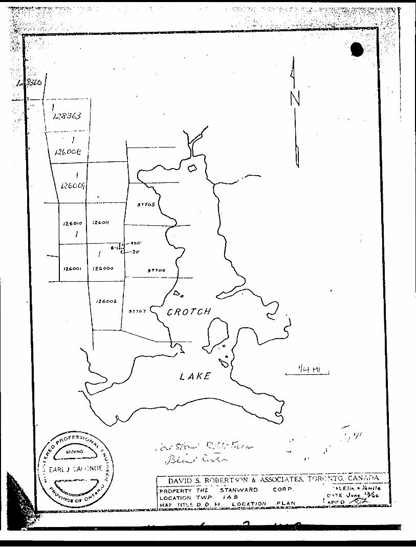
DAV7 1D S. ROBf.RT^N 4t .ASSOCIATE
PROPERTY THE STANWARD CORP.
LOCATION TWP. l A SMAP riTLE D. D. H. LOCATION PLAN*-?*fy^^^gsTrrr^^j^^'-'-^fV;'J7T'^vTrT'^rft'rrwiT*7*-f"*-T'i*"*^' lfca*

41J*7NE9117 *02*Al GUNTERMAN900
•j, ..-- .v.-.^.- -,. : ^.-^f^-., t
^'^•ro^K^y'••IE OFFICIt OF T f
MAKiC...
SAULT
HENTI ^.' MI
ONT.
—-r ^ ii l S.60* ^
Vi' "|O r—
. - / ^ .'9
x -i
\
i C.
A f-
A.'.^ i-DM


Sjvl-T OFFICE OF MINING RECORDER
ONTARIO
DEPARTMENT OF MINES
SUDBURY MINING DIVISION SUDBURY. ONTARIOJuly 6/65
Mr. P. Giblin, •{evident Oeolo^iist,, 1496 iVellin^ton A ve. ''au 11 j" e. IC-jrie, Cnt
inclosed i
:..oci on oi
'
Hi U.-:
,". L Oil.
1^9, in the
/rd
• r .- .rv yc^ ,
i n ;o j jruor
OJUL 7 19"i-
RESIDENT CcuLDGISTSAULT STE. MARIE
NOT TO BE REMOVED FROM
THE OFFICE OF THE RESIDENT
GEOLOGIST, ONT. DEPT. OF MINES^
SAULT STE. MARIE. ONT.
ASSESSMENT WORF
THE MINING ACT REPORT OF WORK
Voetf-M type of work lo b* (•corded.
Tolhe Recorder of... ..Sn.UXt..S.tC....Jb\ai;ie.................................................................Minin9 Division
l, .......J5tanrP.cX..UxaAU\ro.JU.ae.a. , Limited.. .........................................T.-M.......................
nome of Recorded Holder Miner's Licence
.............p....0....3ox..A2B............................,.........^Post Office Address
do hereby report the performance of ...............7.?.?................... days of .-^^.dia.'nond.. drilling ....^type of work
not before reported to be applied on the following contiguous claims
Claim No.
1260.0.0.
126.0.0.2. 126.006 A2.6.0.0.7.
12&OQ8
Days
.5.Q..
.5.Q..
.5.P..
.50..
.5.g..
.50..
Claim No.
.1.2.6011-
.12SJ62
.157.281
Days
5.P....
SO...49...
50...
SO-
SO...
Claim No.
...12.7.^80
...127282
...J .7.7.2-83
...1Z7284
All the work was performed on Mining Claim W ......................S..12.6QQO................................................
(In the case of geological ond/or geophysical survey (s) where more than 18 claims are involved attach o schedulu)
READ CAREFULLY: T HE FOLLOWING INFORMATION i s R EQUIRED B Y THE M INING R ECORDER.
X
Z
For Monuol Work, Stripping or Opening up of Mines, Sinking Shafts or Other Actuol Mining Operations - Names and
addresses of (he men who performed the work and the dates and hours of their employment.
For Diamond and other Core Drilling - Footage, No. ond angle of holes and diameter of core. Norrmond address of
owner or operator of drill. Dates when drilling was done. Signed core log ond sketch in duplicate.
For Compressed Air or Other Power Driven or Mechanical Equipment
Type of drill or equipment. Names and addresses of men engaged in operating equipment and the dates ond hours of
their employment.For Power Stripping - Type of equipment. Nome and address of owner or operator. Amount expended. Doles on which
work was done. Proof of actual cost must be submitted within 30 days of recording,
With each of the above types of work sketches arc required to show the location ond extent of tlic work in relation
lo the nearest claim post. In the case of diamond or other core drilling the sketch must be submitted in duplicate.
For Geological ond Geophysical Survey - The names and addresses of men employed os well as dates. Type of
instrument used in the case of geophysical survey. Reports and mops in duplicate must be filed with the Minister
within 60 days of recording.For Land Survey - the name ond address of Ontario Land surveyor.
O*
The Required Information j s os Follows: (Attach o list if this space is insufficient)
1. AW (l 3/16" diameter) core , (1801 to 2600')
2. Drill owner: continental Diamond Drilling Co
P.O. Drawer 250
w/ Rouyn, Quebec
3. October 20 and still continuing
4. core stored within 50 feet of the collar of S-l
S. S. M
Ltd, i e E i v tDEC 2^1969
K O
i —tu
y CPdf tu OK
IZ
r-fie oCL 1U Of
H
UJ
tusut t/k
U-
V-
t:
The Mining Act Certified)* Verifying Report of Work
hereby. certify:
(Post Office Address)
}. "^Kot l hove o personol and [n, imdte knowledge of the facts set forth in the report of work annexed here-
d same during and 'or after its completion.
S MRESIDENT GECJLOGIST.ccrSSMENT
8AULTSTe.MAR,C ASSEb^W
O Z
tx o
D. Ul X

:A, RESIDENT GEO THE MJN(NC ACT R EPOR7 OF WORK\-r," SAULT Bit* WAiufc
^'To the Recorder of...............Saul.t.jStG*.,Majr.ie............................
r ——— —A t/porolt fo'm li
•rpt if work lo k*IKO'iti.
.Mining Divisionfe: . nome of Recorded Holder
Miner's Licencei.d...Riyer,....Qn.t*r.lp..................................Post Office Address do hereby report the performonce of .......5.5.2.......................... doys of .....AXT-diaiPOad..drilling...
type of work ' not before reported to be,opplied on the following contiguous claims
iSr-r^'
Cioim No.
128351.
1283.61.
12835.2..
1283.54.12835.5.. 12835.3..
Doys
5.CL.
..5.Q.
5.O....
5.0...
49...
Claim No.
S — 12835A
12835.7.
128.359
12836jQ
12600.8
Doys
...50
...50
...S.Q .49..
Claim No.
S i2.6P0.9.
126010
Days
...i..
i o , V -: *
THE OFFJ^E o.- TM:: HL^U o E PT. '8r -
SAULT'S'TE. MARIE;"ONT,AU the work wos performed on Mining Cloim W .......................Srr^tD.O.QQ..............................................(In the cose of geological and/or geophysical survey (s) where more than 18 claims ore involved attach o schedule)READ CAREFULLY: THE FOLLOWING INFORMATION is REQUIRED BY THE MINING RECORDER.
X
Stt O\- zUl
tt a.Zl/tx
fifi-i:b-
For Manual Work, Stripping or Opening up of Mines, Sinking Shafts or Other Actual Mining Operation* - Names andaddresses of the men who performed the work and the dates and hours of their employment.For Diamond ond other Core Prilling - Footage, No. and angle of holes and diameter of cor*. Nome and address ofowner or operator of drill. Dates when drilling was done. Signed core log ond sketch in duplicate.Foe Compressed Air or Other Power Driven or Mechanical EquipmentType of drill or equipment. Names and addresses of men engaged in operating equipment ond the dates and hours oftheir employment.For Power Stripping - Type of equipment. Nome ond address of owner or operator. Amount expended. Dotes on whichwork was done. Proof of actual cost must be submitted within 30 doys of recording.With each of the above types of work sketches are required to show the location and extent of the work in relationto the nearest claim post. In the case of diamond or other core drilling the sketch must be submitted in duplicate.For Geological and Geophysical Survey - The names and addresses of men employed as well as dates. Type ofinstrument used in the case of geophysical survey. Reports and mops in duplicate must be filed with the Ministerwithin 60 doys of recording.For Lond Survey - the name and address of Ontario Land surveyor.The Required Information is os Follows: (Attach o list if this space is insufficient)1. Footage: (2600 to 3152) - 552 feet.2. S-l drilled at -90 000', AXT (l 3/16") core3. continental Diamond Drilling co. Ltd p. O. Drawer 250
Rouyn , Quebec4. Started October 20, 1969 and still continuing5. core stored within 50 feet of the collar of S-l
S. S. MMINIV3
AU I EOIV.
TF32-1970
Dot. ...January....-?.0...... .15.7.0..f S ̂
^... :..^^jtgnaturjKof Recorded Holder or AgoWl
tt O
8toV*
—Ul
*
UL
Ul (Jtt
f
O ft.Ul tt
~X
UJ
iu
Ul f)
u.rC"
rav
The Mining Act Certificate Verifying Report of *ork
^ ,, . ^ v. ,- 5 H S ̂ i'.i i- 1 "t WOR
........................p....a...Box..428, .........................JUin.d.JUyer.,...Ontario........................(Post Office Address) hereby certify:
1. Thot l have a personal ond intimate knowledge of the facts set forth in the report of work annexed here to, having performed the work or witnessed tame during and-'or after its completion.2. That the annexed report is true.
Doted. .January......c?.0...... 19 .l.Q................................r^
o 2Ss K 1O!
iua.uir
O . f ,. X

e u^r F,,.
THE MIMIHC A CT HEPOHT OF WO/JK
A i^ofol* leim il r*qul(*J t** t. .S tjfm tt work to k* record* J. i fi
J'1nomc of Roccrdod Holde-
....................Mii.i.ig
....,.,....T~2A..................Miner's Licence
.80 R .i.chino n.d. .g t r e e. t .v;tj13.t: A ...... .T. p.r on. to.Post Office Address
do hereby report Ihe performance of .....7.43..... ...................... Javs Of
not before reported to bo opplied on the following contiguous cloims
Claim No. Days Claim No. Days
type of work
Claim No. Days
SEE ATTACHED LIST
RESIDENT GEOLOGISTSAULT STE. MARIE
All the work wos performed on Mining Claim (s) ............fiTA.f.r.V.P.P^.'"............................................. .....,...(In the cose of geological ond/or geophysical survey (s) where nore than 18 claims ore involved attach o schedule)
READ CAREFULLY.^ THE FOLLOWING INFORMATION is RE.QuiPE.p SY THE MINING RECORDER.
/-
x;
l-
For Monuol Wprlt, Stripping .or Opening up of Mires, Sinking Shafts or Oilier Actual XUningjOpurcljons^ - Names nodaddresses of the men who performed thr worli ond the daMs ond hours.of iheir employment.For DiomcHid ond other Core Drilling - Footage, No. ond angle of holes end diameter of core. Marne ond eddrcss ofowner or operator of drill. Doles when drilling wos done. Signed core log and sketch in duplicate.Fof Compressed Air or Other Power Driven or Michonicol EquipmentType of drill or equipment. Homes ond oddrnsscs of men engaged in opcrctng equipment ond the dotrs ond hoers cfthoir employment. COFer Power Stripping - Type of equip.-n*nt. None sr'd oddreij of o*ier or operotcr. Amount erpen isd. Dotes on whichwork wos done. Proof of octuol co*t muif b? sub.-nittcd v-ilhin 30 doys of rc:orjing.With each of the above types of worn sketches ore required to shew the location and evlent of the work in rf lotionto tho nearest claim post. In the cose of diamond or other core drilling ths sketch mut? bc submitted in dupficdlo
o i t? .
Fof Geological and Geophysical Su.-vi-y^ - The ncmes end addresses of mtn errpinstrurr.snt us*d in the case oT g^ep.'iysicol survey. Reports end mops in dupticot* within 60 days of recording. For Lend Survey - the name Ond ocMress of Oniorio Lend surveyor.
The Required Information is as Follows:
D
2)3)
4)5)
Dote ..
Footage (3152-3895)S-l drilled at -90 c,Continental Dicirrionci
Rouyn, p. 0.Started October 20,Core stored at Robb
.25..M3.r~h,...197Q... ... ......
eyed os vsM cs dotes. TypJ of ^! rr.uit Lt f.l'-ri *.*i- -*ir M'.ijs'c? ^
1 0•S! 2. S <r™ — *
(Aticch o lis! if ihis ipoce is insufficient' V/rf c: j
743 fe-etA XT ( l 3 /16".) core
Drilling ^om^ar.y Ltd. p.
1969, conpletoil Feb. 10,F nrm in p. li r. J River
~. ..
rA o-'W u.
t ,^~~"~'~~ .1*0. b rawL'r'" 25o'' ;-'; rt p-, j^
i ' , ' :| \ 'i l i.: 1-*-.-. ,' r- .-. '.j iJ \i u* j; ji ur70 ' L! " fy^/S^ . ^1;^ i-
] " J J51 A M P M ^UJ' *"j" *i *^ "* -^' ' * * "^ — , r^ o * * ^** j ̂ *** t- y./..*. ' - ' - 1-' '-'n - .' 1 ' ,- /^ ̂ '*Lj ̂
\ ^
^
o
Th- V,r:-r -'-^ Cerfi'.ccte V..* .-' p ..-.c "-,..-.,-
P.O.
hereby certify:
Doted.
J?sit Ofri,: -iJ.-?**'
to, hoving performed !!is -offe cr *.i trrv.;'^* J i.?."* d-jri''1 ; -.••- c' ,v't.
2 That the onrc - .-i r tr-.v s '•.".
IMQT TO BE RE.MOVED FROM
^—^r-" QP'TH'E RESIDENT
GEOLOO.- . .
25 M.arjii . ..19^,...... . . SAULT. STE
-l 1*8 ASSESSMENT WORK /^
"

if Ifeitg- : ^i^' ; -R^.:^^•v!:v-•^:.^•••vr•--•EplSt^ -:'-ciAIM:N6-;' - ' .
^ S 126000 * - -^-. -.P- W: 126010 '' "-' l 126009 '
126008 ^
128363 '
128360 '128359128358 "
128916 "128917 '
127401 ^
127307 ^
*27288 s
127404 ^127405 "127406 "137407 "
127816
127409 ^
127421127422 ^127423 ^127424 x
. ' :'T' , . " ; --- ' ' - , . ' , . , , '/•-•i ' s "' -•V~^s -T- .PAYS ••-•;;/ ;. .-•., . - ,- -^ - ;. ; - - '^•••'Y^
- 1 ' " -:1 *1 '1 -
1 '
111
5050 -
50 '
50 .
49
505050 -50 .
50 -
50 -•'t
39 *49 -49 '49
Claims are in townships 149 and 150

::^^^6Y^^^- -- ' T^e.-
PROGRESS REPORTTHE OFFICE OF'THE
GEOLOGIST OMT ne.R' ONT- DEPT- OF MINES STANROCK URANIUM MINES LIMITEftAULT STE. MARIE rt
Suite 804 * * ONT- 80 Richmond Street West
Toronto, Ontario
Exploration Permit MX 55/68 File No. 22-R-37
DIAMOND DRILLING
In 1969, Stanrock performed diamond drilling at 2 separate
locations in the Elliot Lake Area. In October, 748 feet of
XRP diamond drilling was performed on claims S127425 and S127285,
held for uranium, in Township 144 on Flying Goose Lake. The
drill holes were of short length testing for copper mineralization
along diabase dykes and, although uranium might have been
found on the dyke edges, no radioactivity was detected.
Also in 1969, diamond drilling was conducted in a former
hole, S-l, claim s-126000, on the west side of Crotch Lake,
Township 149. To the end of 1969 the hole had advanced to
3323 feet and was in the Middle Mississagi Formation some 600
feet above the level where uraniferous beds might be expected.
No radioactivity was detected to this point.
All the claims are held by Stanrock Uranium Mines Limited
and remain in good standing.
F. .. Barnes Ph. D
AUG 14 1970
RESIDENT 'SAUU i... t ,
T^IST