Embed Size (px)
Citation preview
AD-A 2 7 0 753
DRAFT
ENVIRONMENTAL ASSESSMENT
DEACTIVATION OF TI-E SR-71 PROGRAM AT
BEALE AIR FORCE BASE, CALIFORNIA
DTICELECTE
OCT 15 1993
DEPARTMENT OF THE AIR FORCEHEADQUARTERS, STRATEGIC AIR COMMAND
OFFUIT AIR FORCE BASE, NEBRASKA
JULY 1989
93-24133

BestAvai~lable
Copy
JUL-16-19 3 3 09:42 FROMi HO ULSAF CEF TO , i F',O2
of M Ar Force4 ' Environmental Planning Dtvision
Uo (HQ USAFICEVP)
v I Rocca 53691260 Air POW PO8M''vas W gm 7DC 2033014260
IUL t6/'93 _' 3
(Arrow I [] #Ii#onyn
md 1AM
DSH 227-2M2
JUL lb'9693
XOKO)O= PDEA
MUBLE OF CTZ11EMS
Section
1.0 PUROS OF AND NEE FO TM4 PROPSE AMTON .......................... 1-1
1.1 P ......................................................... 1-1
1.2 NEED FOR P PROPOSED AMCTKO .................................... 1-1
1.3 ILCATIC, HISIW, AND MISSIM OF BEATE AF F ..................... 1-1
1. 3.1 location ................................................. 1-11.3.2 History .................................................. 1-i1.3.3 Mission .................................................. 1-3
1.4 EXISTNG DEVELOPMEMTAT BEATE AFB ............................... 1-4
1.5 SOOPE ............................................................ 1-6
2.0 ALM;T 1VES CO) INIUM• 7 PRPSED ACT... ................ 2-1
2.1 PROPOSED ACMION .............................................. 2-1
2.1.1 Sniaz of the SR-71 Program ............................. 2-1
2.1.2 Deactivation of SR-71 Program ............................ 2-2
3.0 AFECTED VIMME ............................................... 3-1
3.1 INTROUCTION .................................................... 3-1
3.2 AIRRESOURCES ................................................ 3-1
3.3 WATER RCES .............................................. 3-4
3.3.1 Regional Settig ..................................... 3-4
3.3.2 Groudwater Conditions at Beale AFB ...................... 3-83.3.3 Surface Water Across Beale AFB ........................... 3-8
3.4 BIOLOGICAL RESOURCES ........................................ 3-10
3.4.1 Sensitive Species and Habitats on Beale AFB ............. 3-103.4.2 Flightline Area ...................................... 3-113.4.3 nt ent Area ..................................... 3-11
3.4.4 Family Housing Areas ............................ 3-12
7/11/89
* AE
Section
3.5 NOISE .......................................................... 3-12
3.5.1 Introduction ............................................ 3-123.5.2 Existing Noise Coriitions ............................... 3-12
3.6 SOCIO EC O CS ................................................. 3-15
3.6.1 Dem raphics ......................................... 3-153.6.2 Economic Characteristics ................................ 3-17
3.7 AIR SAFETY ..................................................... 3-2(
3.7.1 Base Facilities ......................................... 3-203.7.2 Flying Operations ....................................... 3-21
3.8 WASTE DISOSAL ............................................... 3-24
3.8.1 Solid Waste Disposal ................................... 3-243.8.2 wastewater and Sewage Disposal .......................... 3-26
4.0 ENVIRn4 D 1 L csm @ rEs OF THEPROSD AC O .................... 4-1
4.1 INTRODUCTION .................................................... 4-1
4.2 CONSE CES TO THE PHYSICAL AND HUMAN ENVIRNMENTS ............. 4-1
4.2.1 Air Resources ............................................ 4-14.2.2 Water Resources .......................................... 4-14.2.3 Biological Resour ................................... 4-14.2.4 Noise ................................................. 4-24.2.5 Socioeonunics ........................................ 4-24.2.6 Air Safety ............................................... 4-34.2.7 Waste Disposal ........................................... 4-3
4.3 MITGATIK MEASUR .......................................... 4-3
4.4 ADVERSE 2Th TKýAZ CANNOT BE AVOIDED IF TME PRPOSED ACI7ONIS ................................................. 4-3
4.5 IRREVERSIBE AND IFW RIEVABLE CMI2MM OF RES(XRCES .......... 4-4
4o6 RELATIONSHIP BEIWEEN SHOir-'R USES AND ICNG-TEIPR ivi''y... ................... . ..................................... 4-4
7/11/89 ii
Th= ~ CP0R IILc*zn
secticn
5.0 S M OF FRIN GS .................................................. 5-o
6.0 R4 ........................................................... 6-1
7.0 LIST OF PREPAR AND CFAIZATICHS AND PERSCHS CtlT D ............ 7-1
APPEX A: EEFINITFICNS OF NOISE !E1S4M1R .......................... A-i
7/11I/
j D. i i:! ..
Vt
r-c ~Th-t
7/11/89 iii
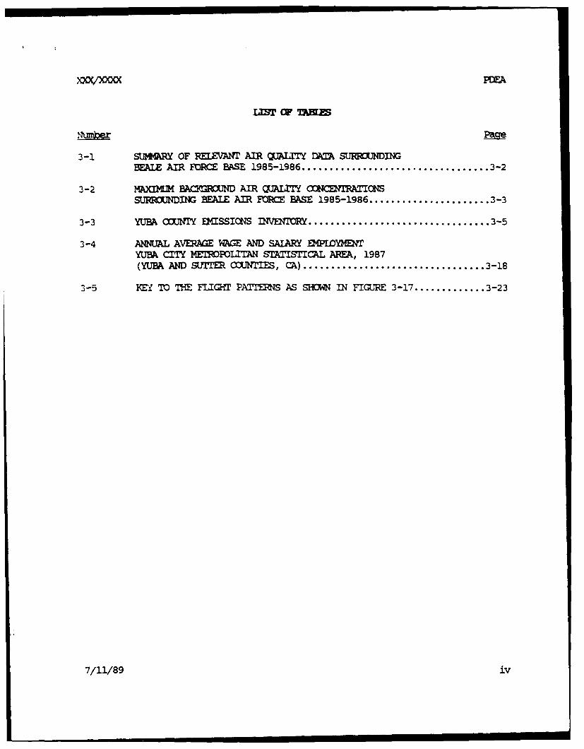
PDEA
3-1 SUM4ARY OF RELEVANT AIR QUA=IY DATA SURROUNDINGBEALE AIR FURCE BASE 1985-1986 .................................. 3-2
3-2 M@xI4M BACYfROUND AIR QUAI= CONCENTRAT'IONS
SUFONDING EAIE AIR FORCE BASE 1985-1986 ..................... 3-3
3-3 YUBA COUNTY EMISSIONS INVENTORY ................................. 3-5
3-4 ANNUAL AVERAGE %kGE AND SALARY EMPLOYMENTYUBA CITY METROPOLITAN STATISTICAL AREA, 1987(YUBA AND SUT COUNTS, CA) ................................. 3-18
3-5 M TO T FLIGHT PAXI'NS AS SHON IN FIGURE 3-17 ............. 3-23
7/11/89 iv
XXO0OO= PEA
I"IST CIF FIGURES
1-1 GENERAL ILCATICK MAP ............................................ 1-2
1-2 FNCTICI AL AREAS ................................................ 1-5
1-3 FLIGH•n AND (A •NM~ AREAS ................................. 1-7
1-4 FAMILY HOUING AR;EA ............................................. 1-8
3-1 MAJOR SURFACE WATER RAINAGE SYS ............................ 3-9
3-2 COC0N A-WEIGHTED E SOUND LEVELS ................... 3-13
3-3 NOISE CCONT•O .S............................................... 3-14
3-4 -T= OF CAMFOI4IA LAND USE C3MPATIBILITYFOR AIRCRAFT NOISE .......................................... 3-16
3-5 BEALE AFB FLIGEM PATENS ..................................... 3-22
3-6 WASTE DISPOSAL FACILITIES IOCATIN ............................. 3-25
A-i EXAMPLES OF DAY-NIGHT AVERAGE SOUND LEVELS, Ldn ................. A-4
7/11/89 v
1.0 P CF AND NEED PUR TM -KI-0 ACTIUI
1.1 ,PUR
The United States Air Force (USAF) Strategic Air Cammand (SAC) has
proposed to deactivate the SR-71 program currently operating as part of the
9th Strategic Tennaissarc Wing's (9th SW Mission at Beale Air Force Base
(AFB) near Sacramento, California. This mission change is anticipated to
take place coincident with the beginning of fiscal year 1990. An
Envirormntal Assessment (EA) will be prepared to determine the significance
and extent of potential inpacts that may occur as a result of the proposed
action. This EA is prepared in accordance with the National EnviromentalPolicy Act of 1969 (NEPA), as stipulated in regulations prcmalgated by the
Council on Environmental Quality (CEQ) (40 CFR 1500-1508, Novemiber 1978), and
Air Force Regulation (AFR) 19-2.
1.2 NEED FOR• = P F0SF A=CTIC
The USAF SAC has determined that it cannot continue the SR-71 program
in light of its high operating cost, required manpower needs, and necersaryground-based support functions and facilities. The reconnaissance mission
will be accouplished through continued U2 flights and satellite technology.
1.3 IDCKXtI. HLSC, AND MISSICI OF EAIE AMB
1.3.1 Incation
Beale AFB currently consists of 22,944 acres of governmnt-owned land in
Yuba County, approximately 40 miles north of the city of Sacramento and 13
miles east of Marysville, in north-central California (Figure 1-1). The
foothills of the Sierra Nevada mountains border the eastern edge of the base,
while the Yuba River to the north, the Bear River to the south, and Canp FarWest Reservoir to the southeast are the nearest large water sources. Other
neighboring cities are Yuba City, 16 miles west; Oroville, 40 miles north;
and Grass Valley, 25 miles east.
1.3.2
Beale AFB, named for General Edward Fitzgerald Beale, opened in October
of 1942 with more than 86,000 acres of land. During World War II, the campwas used as an infantry training cenyer, a personnel replacement depot, and
7/11/89 1-1
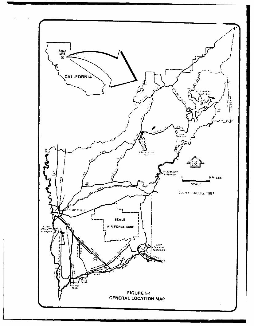
CALI FORNIA -
B I i 4.R1,5R~
-T'
0 5SMILESSCALE
Source- SACOG. 1987
GENEALE LCTO A
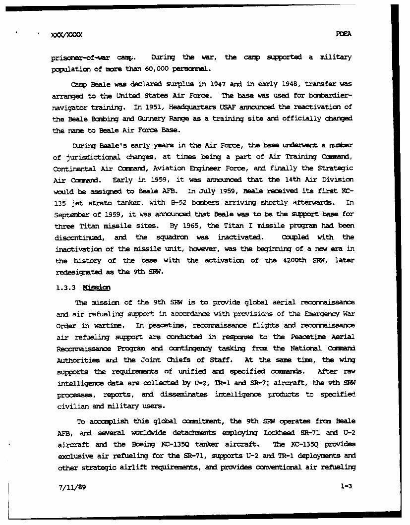
priso*r-of-war cazp. During the war, the canp supported a military
population of more than 60,000 personnl.
Camp Beale was declared surplus in 1947 and in early 1948, transfer was
arranged to the United States Air Force. The base was used for bombardier-
navigator training. In 1951, H-adquarters USAF annoiunced the reactivation of
the Beale Boabing and Gunnery Range as a training site and officially changed
the name to Beale Air Force Base.
During Beale's early years in the Air Force, the base underwent a number
of jurisdictional changes, at times being a part of Air Training Comd,
Continental Air Ccmmand, Aviation Engineer Force, and finally the Strategic
Air ccmmand. Early in 1959, it was announced that the 14th Air Division
would be assigned to Beale AFB. In July 1959, Beale received its first Ic-
135 jet strato tanker, with B-52 bcobers arriving shortly afterwards. in
September of 1959, it was anniourm that Beale was to be the supot base for
three Titan missile sites. By 1965, the Titan I missile program had been
discontinued, and the squadron was inactivated. Coupled with the
inactivation of the missile unit, however, was the beginning of a new era in
the history of the base with the activation of the 4200th SW', later
redesignated as the 9th SFW.
1.3.3 Mission
The mission of the 9th SRW is to provide global aerial reconnaissance
and air refueling support in accordance with prcvisions off the Emergency War
Order in wartime. In peacetime, reeccmaissance fli,#ts and reconnaissance
air refueling support are conducted in respose to the Peacetime Aerial
Reconnaissance Program and cantinqency tasking from the National Ccmmand
Authorities ard the Joint Chiefs of Staff. At the same time, the wing
supports the requirents of unified and specified cammands. After raw
intelligence data are collected by U-2, 7R-1 and SR-71 aircraft, the 9th SRW
processes, reports, and disseminates intelligence products to specified
civilian and military users.
To accomplish this global ccunitmeznt, the 9th SRW operates frum Beale
AFB, and several worldwide detacments employing LocIkhd SR-71 and U-2
aircraft and the Boeing KC-135Q tanker aircraft. The KC-135Q provides
exclusive air refueling for the SR-71, supports U-2 and TR-l deployments and
other strategic airlift require•ents, and provides conventional air refueling
7/11/89 1-3
suport for other Air Force aircraft. Northrop T-38A aircraft provide anintegral part of the training of SR-71, U-2, and R-i pilots and KC-135Qcopilots throug specially tailored flying prorams that meet the
requirements of each pilot's specialty.
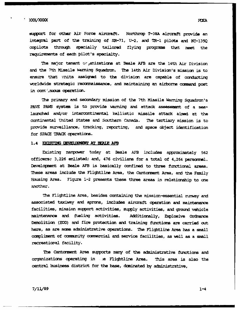
The major tenant orjanizations at Beale AFB are the 14th Air Divisionand the 7th Missile Warning Squadron. The 14th Air Division's mission is to
ensure that inits assigned to the division are capable of ccrd
wrldwide strategic recorraissance, and maintaining an airborne amznad post
in cont %Aws operation.
The primary and seccrdary mission of the 7th Missile Warning Squadron's
PAVE PAM system is to provide warning and attack assessmant of a sea-
launched and/or intercontinental ballistic missile attack aimed at thecontinental United States and Southern Canada. The tertiary mission is toprovide surveillance, tracking, reporting, and space object identification
for SPACE TRACK operations.
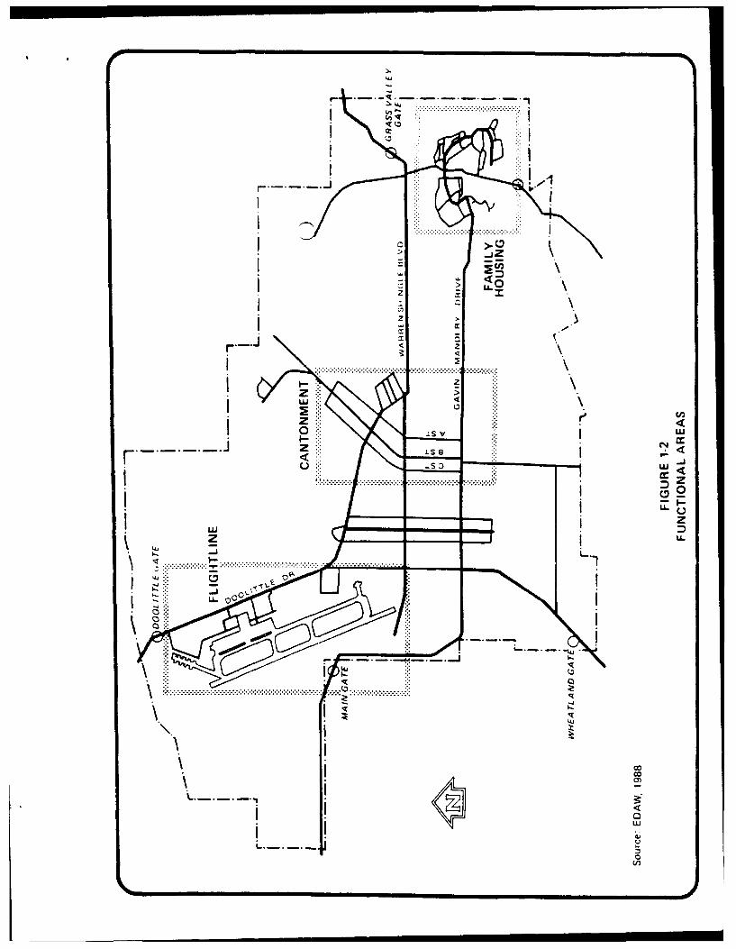
1.4 EXLSTIN( UnEgLDRII' AT BIE AFB
Existing manor today at Beale AFB includes approximately 562
officers; 3,226 enlisted; and, 476 civilians for a total of 4,264 personnel.Development at Beale AFB is basically confined to three functional areas.
These areas include the Flightline Area, the Cantonment Area, and the FamilyHousing Area. Figure 1-2 presents these three areas in relationship to one
another.
The Flightline Area, besides containmixg the mission-essential runway andassociated taxiway and aprons, includes aircraft cperation and maintenance
facilities, mission support activities, supply activities, and ground vehiclemaintenance and fueling activities. Akditionally, Explosive Ordnanc
Demolition (EOD) and fire protection and training functions are carried outhere, as are some administrative operations. The Flightline Area has a smallcomplimeint of caumnity cimercial and service facilities, as well as a small
recreational facility.
The Cantonment Area supports many of the administrative functions and
organizations operating in -e Fli4htline Area. Ths, area is also the
central business district for the base, duminated by administrative,
7/11/89 1-4
zzIL__
IS v u.-J cc
U. 000
co,
caimuity ocaimercal, unar, aid homingq, andi industrial uses. ocial,
maintenance, medical, and spiritual facilities are located here as are base
engineering and envirormental operations.
The Family Housing Area provides base housing fc,- officers and enlisted
personnel. A fire station and an administrative office are also present
here. A rnmber of other cormuuty service and camnercial activities are
located here as well as recreational facilities.
Figures 1-3 and 1-4 present locations of various facilities that are
located in each of these three areas.
1.5 SCOPE
A separate Environmental I:mact Statement (EIS) is currently being
prepared to evaluate potential impacts associated with an unrelated proposed
action at Beale AFB to relocate the 323rd Flying Training Wing - the
Specialized Undergraduate Navigation Training (SUNT) - currently operating
out of Mather AFB to Beale AFB. The relocation of the SUMW to Beale AFB was
by the Commission on Base Realignment and Closure (Commuission) to
take advantage of the decision to deactivate the SR-71 program at Beale AFB
and improve imiltiservice training.
Major issues to be addressed in this EA were identified throh
discussions with USAF personnel who are familiar with the mission and
operation requiremnts of the SR-71 program, and review of a previous EAprepared by the tsAF dated September 1988 for a proposed, but unrelated,
mission change for SR-71 and T-38 aircraft at Beale AFB. Based on these
discussions and review, it was determined that the proposed action would have
the potential to affect air quality, noise levels, and air safety from
reduced flight operations, reduce potential sources of surface and/or
grurudwater omntamination from a decrease in aircraft refueliM activities,
affect socioeconumic concerns resulting from a loss in USAF and civilian
employment opportunities, affect solid waste ard liquid waste disposal
operations resulting from decreased demand for these services, and may have
the potential to adversely affect biological resorces in the Fliohtline Area
where SR-71 aircraft operations and maintenance activities are conducted.
"7/11/89 1-6
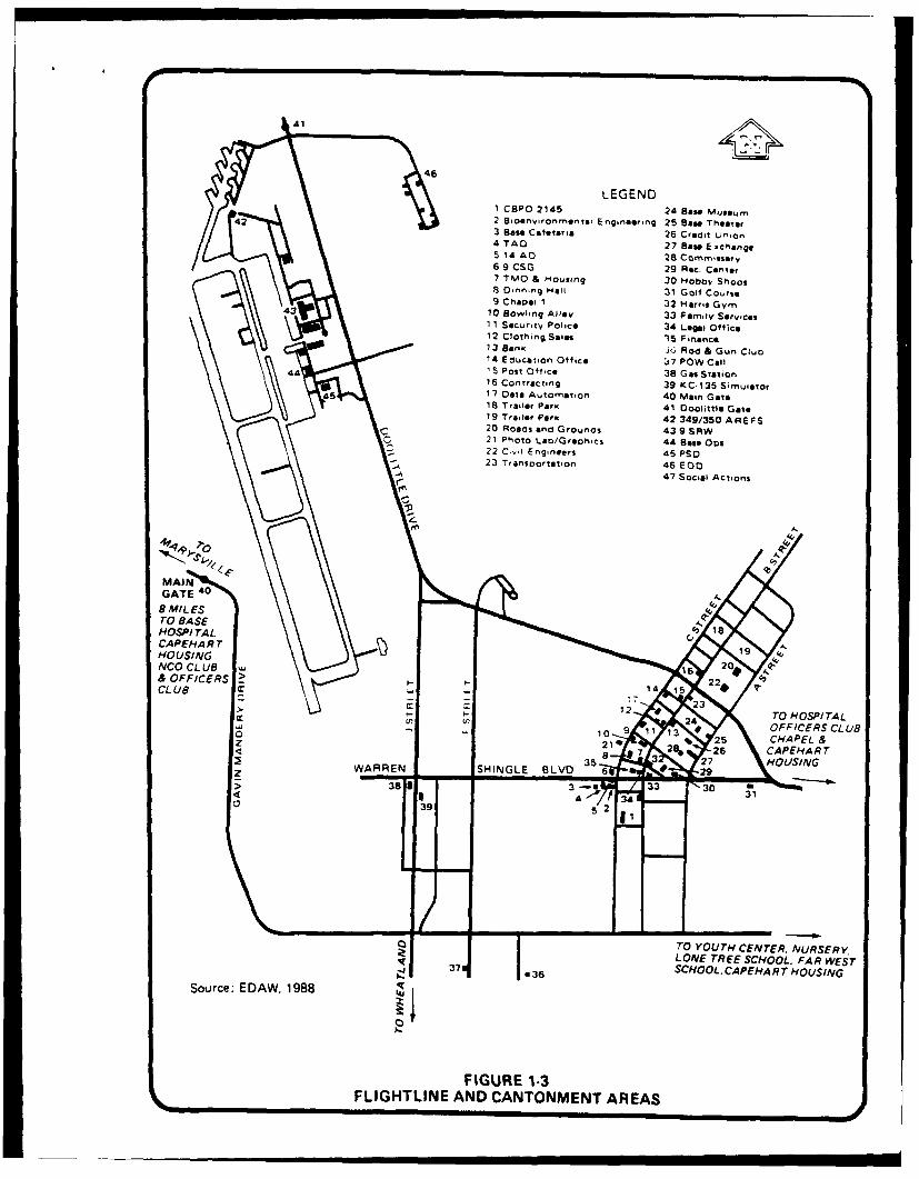
LEGEND1 CBPO 2145 24 Bao" kMu&*eu
42 ~2 Bico ""I r ommntal E ngineering 25 Bae" TheaterB ass Cafteraia 26 Credit union4TAO 27 Baso Ex c man go
5 14 AD 28 Comm'ssary6 9 CSG 29 Rec. Center7 TN40 & Housing 30 Hobbv Shoos8 Dinning Hall 31 Gott Course9 Chaosti 1 32 Harris Gymn
4310 Bowling Allot, 33 Family Sorrvices1 1 socu'.1y Police 34 Legal Office12 Clothing Sales 15 F inance
so13 Bank 36 Rod & Gun Cluo14 Education Office ý7 POW Call
441 Post Office 38 Gas Station16 Contracting 39 KC-135 Simulator
4517 Data Automation 40 Main Gate18 Trailer Park 41 Doolittle Gate19 Trailer Paric 42 349/350 AREFS20 Roads and Grounds 43 9 SAW21 Photo Lan/GraohiCs 44 Base Oos
22 C- Engieers45 PSO-23 Transoortation 46 EDO
47 Social Actions
HOTo TASITA
S* 9 26CAPEHART A
SCUOOLG CAEAR9 OSN
Souce ED8 19885
FIGUR 13
<LGTIN AN CATNMN AREAS 726 CAEH

>N
/GRASS VALLEY GATE
7 JARREN SHI4NGLE BLVD) DRY CREEK.4-TCANTN~fETARE VOGSADDLE CLUB
TO CANTNEN BEOO (Private)
o7* NCO CLUB3
OFFICERS; BealeCLU Lake Dr. Creek
FAMILY HOSINGHARE
An analysis of mxalative i=Lpacts re ltIn frf the rlocatio of theSUMT to Beale AFB in conjurntin with the deactivatimn of the SR-71 programwill be addressed as part of the SUNr EIS and rut included in this EA.
7/11/89 19

2.0 AT.2209nTM 'VIS3OS MRC[]mEG ME, PF4PCV ]pMMMs)
2. 1 IO
2.1.1 %no of the SR-71
The 9th SO4 maintains and operates a small fleet of Lockheed SR-71aircraft from Beale AFB for the principal purpose of acquiring worldwidehigh-altitude flight reconnaissanc information and other data to supportUnited States strategic and/or national defense objectives. The SR-71program at Beale AFB has established and maintained Beale AFB as its main hubof operations since the SR-71 aircraft and support facilities became opera-tional in the late 1960's and early 1970's. The SR-71 progra- is currentlyoperated by a staff of approximately 67 officers, 519 enlisted personnel, and38 civilians for a total of 624 personnel at Beale AFB.
The Flightline Area of Beale AFB serves as the principal location forthe SR-71 operation and maintenanc facilities. These facilities includehangers, personnel support facilities, a unique flight simulator facility,mintance and repair facilities, and planning and operational facilities.In addition to these grourd-based support facilities, the SR-71 program alsoincludes the use of T-38 aircraft (tanden-seated, fighter-type aircraft) usedby SR-71 flight crews for training exercises, and Boeing MC-135Q tankeraircraft that provide in-flight air refueling support.
Principal jet aircraft operating from Beale AFB and t!. average dailytakeoff or .raticns by type of aircraft are shown below (SAwoG, 1987).
Aircraft Type No. of Takeoffs Perc e
T-38 68 39V-2/'IR- 62 36IC-135 27 16Transients 10 6
SR-71 6 3173 100
As shown by the above numbers, 3 percent of daily flight operations areSR-71 aircraft. It shou.ld be noted that the number of T-38 and MC-135takeoffs shown above do not necessarily represent direct support of the SR-71program only. Data are not available that break dwn flight information for
7/11/89 2-1
SXXVX/D PW•A
aircraft takeoffs which directly suport SR-71 flight operations. T-38
trainers and MC-135 tanker operations also support other USAF functions at
Beale AFB in addcition to the SR-71.
The SR-71 mission is maintained at a high level of prsparedness. In
order to acc -ui dAte this, rmarous flight training patterns are used by SR-
71 aircraft througout the western United States. These flight patterns have
been developed to provide adequate training areas for SR-71 crews and avoid
populated or otherwise sensitive geographic areas. The unique flight
characteristics of the aircraft (maximLum altitudes above 80,000 feet and
maxinmum airspeeds in excess of Mach 3) have been known to cause loud sonic
bocms on deceleration an4/or decent. Ninety-five percent of the 217 noise
coplaints received by Beale AFB personnel in 1988 have been attributed to
these sonic bocms (Captain Rcnquillo, Personal crunication, 1989).
As a result of air speeds in excess of Mach 3, the aircraft creates
quite high skin-friction temperatures during flight. The aircraft actually
expands several inches in flight as a result of these hich-skin teIperatures.
This design consideration required the developmnt of a unique jet fuel (JP-
7) for use in the SR-71. JP-7 is typical jet fuel with special additives
that elevate its flash point to avoid inopportune and unanticipated cn-
bustion during flight.
The ability for the aircraft to thermally expand in flight has caused it
to leak fuel when at rest at ground-level ambient temperatures. Over the
years, fuel leakage and runoff fro SR-71 operations has been attributed to
large part to the contamination of a small drainage that leads from the
flightline area south of the xI.stirng rumay, and an area in the vicinity of
the SR-71 hangers adjacent to the nrumy. These locations have been ident-
ified as sites 1 and 5 respectively under the Base Installation Restoration
Program (Aerovirormnnt, 1987).
2.1.2 Deactivation of SR-71 Pg
The SR-71 aircraft will be flown to USAF storage facilities in the
Southwest at the completion of mission assignments. Other aircraft such as
the T-38 and IC-135Q used to support the SR-71 will be reassigned for other
training or refueling activities at Beale AFB or other USAF installations.
officers and enlisted military personnel will be reassigned to other USAF
duties at Beale or other USAF installations. Civilian personnel associated
7/11/89 2-2
with the SR-71 will either be reassigned or dismiasoW.
It is anticipated that the JP-7 fuel facilities (storage tanks,
pipelines, puMs, etc.) will be omvertW to aocum date the use of typical
jet fuel for other Beale AFB operations. Other base facilities associated
with the SR-71 prom, such as banger space, maintenwire, storage, are
operation buildings, will remain and beome available for other base use.
2.2 ALTERNATIVES
To be provided.
7/11/89 2-3
3.0 AFFE, ]Nv"RONEMIr
3.1
This section presents discussions of existing conditions for specific
disciplines that, based upon discussion with Beale AFB per e, may havethe potential to be affected by inplementation of the proposed action. These
disciplines include air resources, water resources, biological resources,
noise, socicecncmics, air safety, and solid and liquid wastes.
3.2 An REt
Beale AFB is located in southern Yuba County and occupies portiom ofthe Sacramento Valley and Mrintain Counties Air Basins for whirch the
California Air Resources Board (CARB) reports ambient air quality data. The
closest air motitoring stations reporting to the CARB are Auburn, Yuba City,
Pleasant Grove, and North Highlands. These stations monitor ozoe (03),sulfur dioxide (SO2 ), nitrogen dioxide (N2), carbon mnxoxide (C), and 10-micron particulate matter (PM10). The Auburn monitor, located approximtely
16 miles southeast of Beale AFB, collects 03 data. The Yuba City monitoringstation is located 13 miles west-northeast of the base and mcrditors 03 and
PMI0. The Pleasant Grove station is situated approximately 20 miles south ofBeale AFB and collects 03; and the North Highlands monitor is approximately 5.les south of the Pleasant Grove station and samples SO2 , 03, CO, and NO2.Air quality background c trations for 1985 throug 15,87 collected at
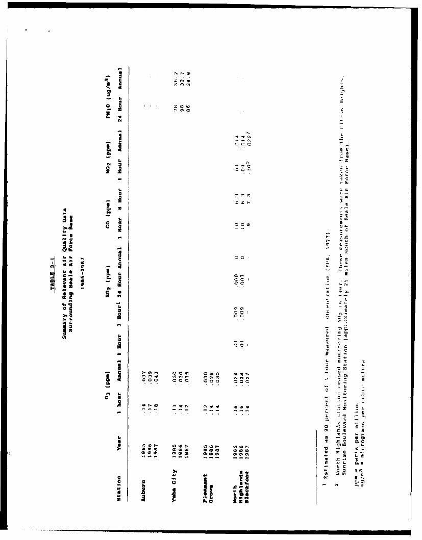
these stations are presented in Table 3-1.
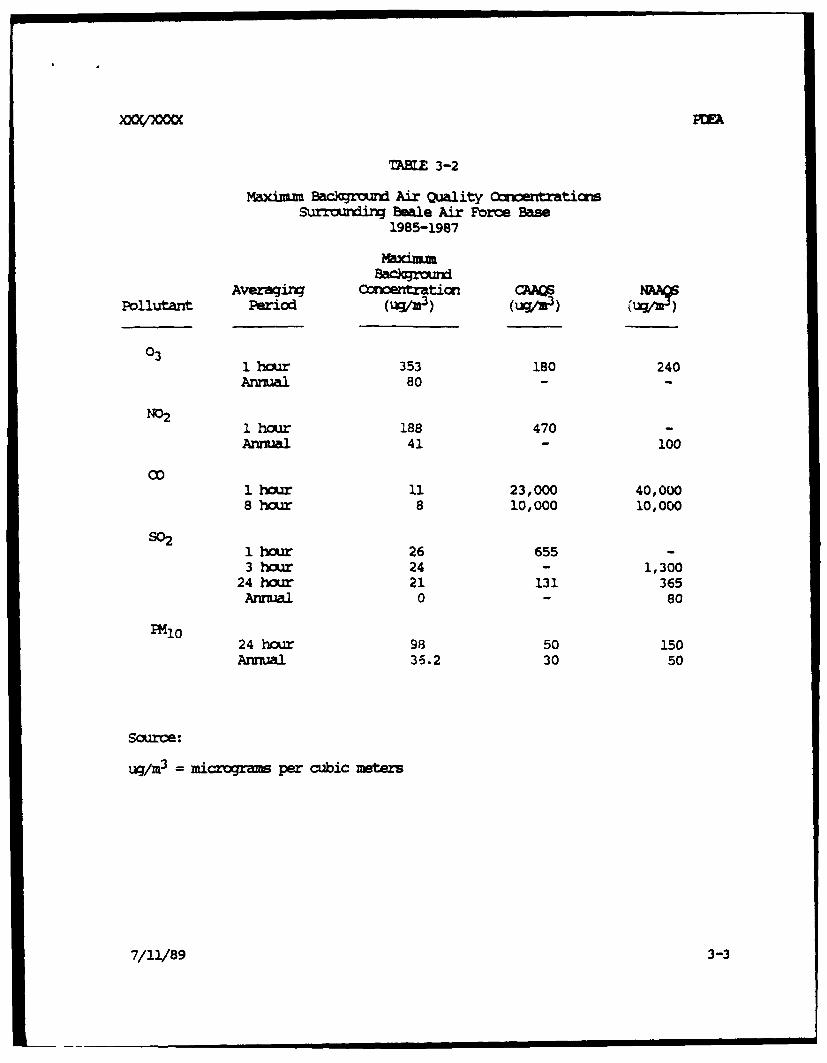
MaxiMUm background air quality data from the above-mentioned table arecompared to National Ambient Air Quality Standards (NAAQs) and California
Ambient Air Quality Standards (CAAQS) in Table 3-2. This table shows thatState and Federal 1-hair 03 standards and State 24-hour PM1o stardards wereexceeded at least once within the 1985-87 data collection period.
The United States Envircamntal Protection Agency (EPA) has designatedYuba County an attainment area for all pollutants except 03. An attairment
area is a region or air basin in which monitored air quality levels are in
compliance with the NAAMS. The baCkgraird data listed in Tables 3-1 and 3-2
7/11/89 3-1
IdIx cc
4 C64
92 1,('
c =
4" -- ..
.c.
- a 16
06 c5 in a c cc r ajoc 0 o a c-34
- --- - -- -
0 Cc
1 cc%a Hý %n a---D
0 Cc:01
('Iw
* 4
TABLE 3-2
Maxinum Backgrozd Air Quality CrntraticrsSurrounding Beale Air Force Base
1985-1987
MaximuBackrazd
Averaging Concentraticn CAAPollutant Period (Wu/M3 ) (im) vl)
031 hour 353 180 240Annual 80 - -
1 hcur 188 470 -Annual 41 - 100
1 houar 11 23,000 40,0008 hOUZ 8 10,000 10,000
s021 hour 26 655 -3 hor 24 - 1,300
24 hour 21 131 365Annual 0 - 80
PM1024 hour 98 50 150Annual 3-.2 30 50
Source:
uq/m3 = micrograms per cubic meters
7/11/89 3-3
show that the 24-hour M10 CAAS standard of 50 u/m 3 was violated at theYuba City station in Sutter County at least once during the 1985-87 sanpling
period.
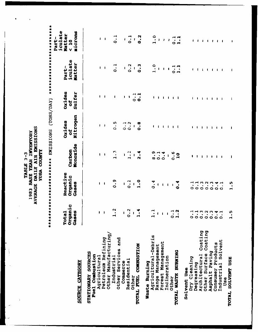
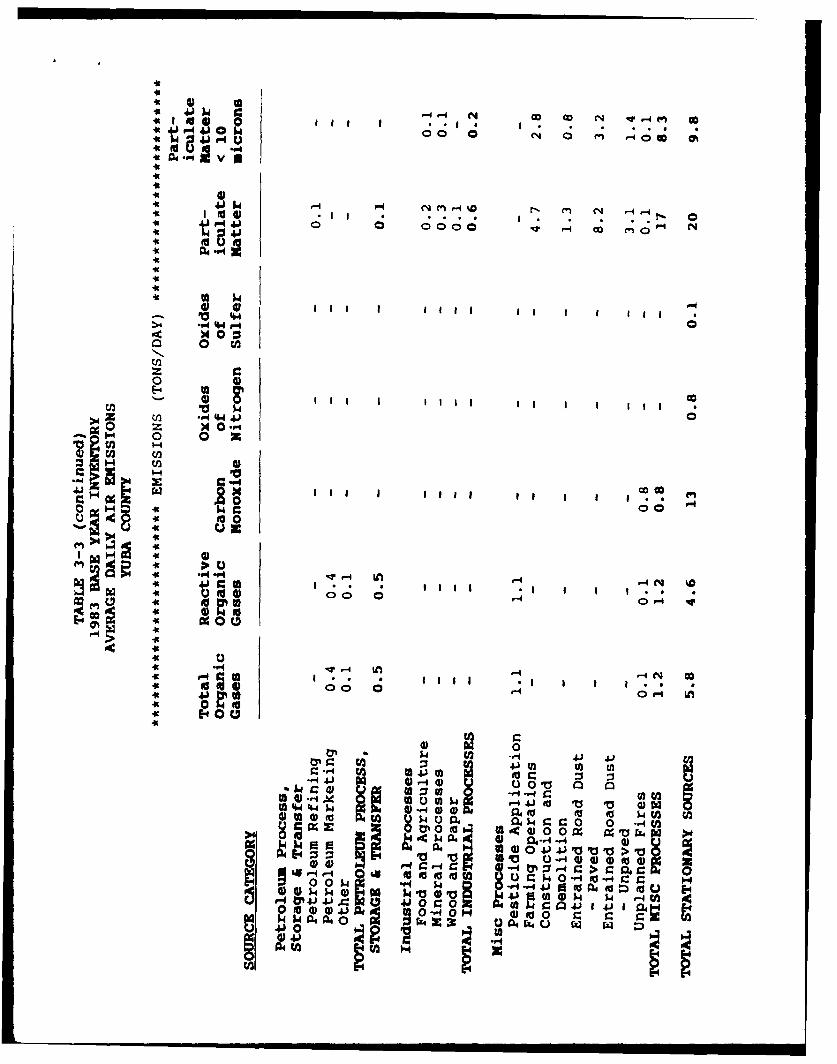
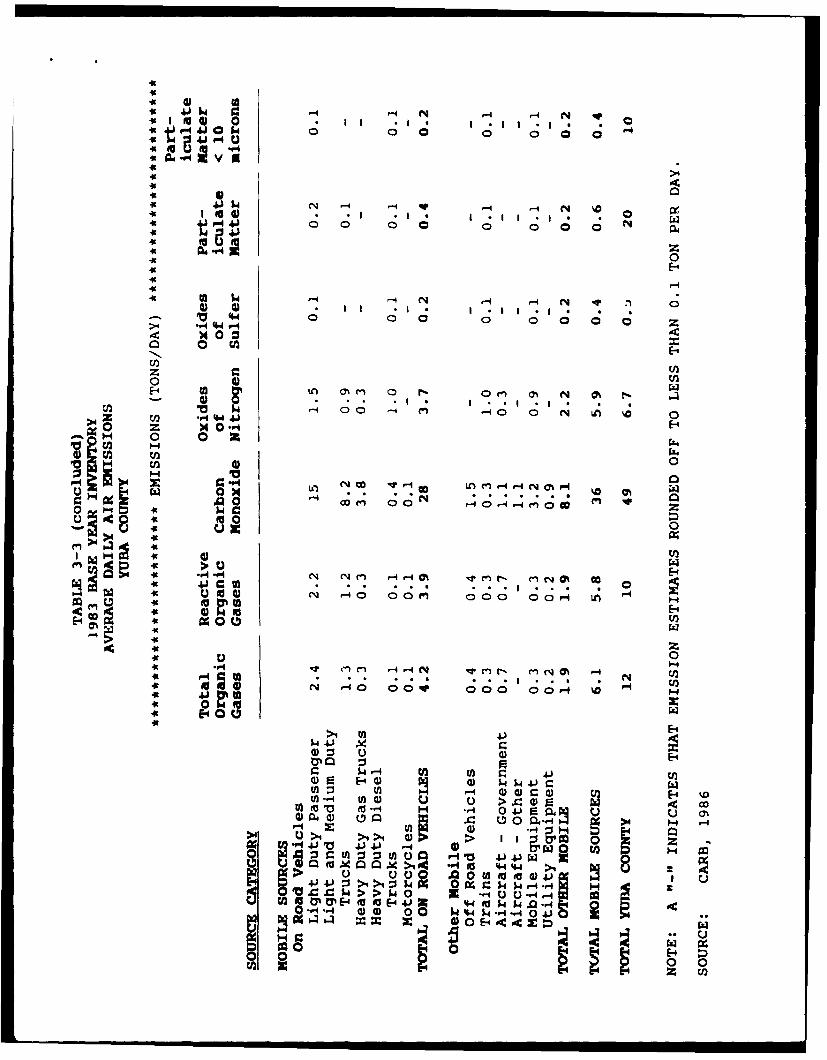
CARB also reports the average daily air emissio for air basins andcounties based on information provided to them by each Air 1llution Cm-&trlDistrict. This information for Yuba County for 1983 (the u-st currnt dataavailable) is presented in Table 3-3. Sou~rces of emissias are presented bycategory. In this inventory, aircraft operating from Beale AFB arecategorized under Other lbile Sources as Aircraft-Cavezrnment. This cateoryof sources contrib.ted less than 6 percent of the total organic gases, 7percent of the reactive organic gases, slightly more than 2 percent of thecarbon monoxide, and less than 5 percent of the oxides of nitrogen emitted
county-wide.
3.3 RM m
3.3.1 Region:l
Beale APB is drained by three principal drainage systems. Te flow ina general southwesterly direction and are identified from east to west as Dry
Creek, Hrtchinson Creek, and Reeds Creek. Hutdunscn Creek and Reeds Creekare classified as intermittent, while Dry Creek is a perennial stream. Inthe spring, vernal pools (perched or standing water) can be observed on andaround Beale AFB in low-lying areas. Ths ccndition is caused by thepresence of near-surface clays and hardpans that are relatively impervious tothe vertical movement of water (Aerovironint, 1987).
Groundwater mmveisent in the region has historically been in a directionfrom the Sierra Nevada foothills eastward to the Feather and SacramentoRivers. Until the early part of this century, the river system served as agroundwater discharge system. Hmwe , extensive farming and irrigation inthe Sacramento Valley area rapidly iwered the water table and altered thedirection of flow, thus changing the river fram a discharge to a recharge
system (Aerovirrment, 1987).
7/11/89 3-4
4IJI~ 14 1-4 -4 N 0qP-
01 0 0-i
v
.k FaP 4 0. 0 P0 4
x 0 0~
0 C
o
z x0 -A
- 0 0U3O H
10 0 4' C Lt0c 0* 0o 0 0 0 0
it -P4 C'%I ON ' - - N-4 ' ~ ~ r 4 L
0t to yl 0.- 0 0 0 0; -
"-O 414 10)
it 41 ) 00 W0 UC L'E-44 0IH ai
CO 4U 0) to to lz 0 0 .4 4. 0)
44 ) a E1 0 4 4) c v 01
0 V 0-~C CO 4J 4) k~ 4J-44)t w0' z' d 0o -M .Ieauz H ~ 0 a'0 N
M) C u.
4t4t
.0 - -4 ý4 NN c-D C4 f-c4t QI * *r. 00- 0101 00 00a O
it
-k 0
it W
C13
M 0 0
E-4
1-4 W ,I.. 0 ~- 1 - -N '
* a.4 ~4 IA a-
80 I
4c0
4csr-4 U) -a4.~) 4'U
t~-a 0O 00 0
0~~ -W Ix0
to 4) 00 go~O411)
0--41- E-4 0 U
-4U 4.1 w 4) 4 1
.~'4 -4 '-4 N
p 0 aa - a a
4>4itC
49A 41.dN .4 '~-4 4 4 ~It 4J-4J0 0 0 0 0it
a Z'a 0
IcE-4949
>E-
0 4 U)
En 4)* m 0 -P*a *
-~ H 0 0 z4U) cn 4
V) 0r- 4 1 o0 - -
(%J LO co 0 W-
"04 4, Clu2
'a 4>4 04 9
41'
0-0
iS to 4) CN '-40 0oe0 co o L
P-4 r -4 N v cn (n N~
a 000 00 00.-f Va F-
44 E-4 0
>1 t
W 4 r-40 4) Ens-JIfl)U E-4 $4 4.)r_tW-..4 Mfl4) >I 4 9) R A(-4 H *.ý4 0 41 R 4 N
00 - 00 C30c'4- 4 >4 H ->1 4 4) R > I I 1 & m 0
41~ ~ 41 4100. 0. t
>*~- 40) 0 0 ý A 'C 004
m 0 E-44O-4C'2
x2 U
JpOJppp[ PDFA
3.3.2 G9Mracxhmt oditiCK' at Be1ne hPB
Grondwater generally flows in a westerly/southwesterly direction acoss
the base. The most obvious groundwater characteristic in the area is intense
drawdown southwest of the base boundary caused by irrigation pumping.
Between 1945 and 1974, the water table fell about 60 feet, then stabilized in
the mid-1970s. However, between 1977 and 1980, the water table declined
sharply once more, in respunse to drought and ineased irrigation for rice
production (Aeroviroimnt, 1987). Since 1980, the water level has risen
markedly as a result of increased precipitation and lower rice production.
Nevertheless, the overall drawdown has been sufficient to alter the direction
of local flow in the area of the base well-field from west to nearly south.
It is assumed that grourdwater tapped for base use is basically uncon-
fined except where local clay/silt lenses cap the aquifer to produce semicon-
fined conditions. Fresh water occurs at a depth of between 300 and 500 feet
below the surface under most of the base. There are no known historical
proble•s of man-made contamination of local groundwater supplies (Aeraviron-
ment 1987).
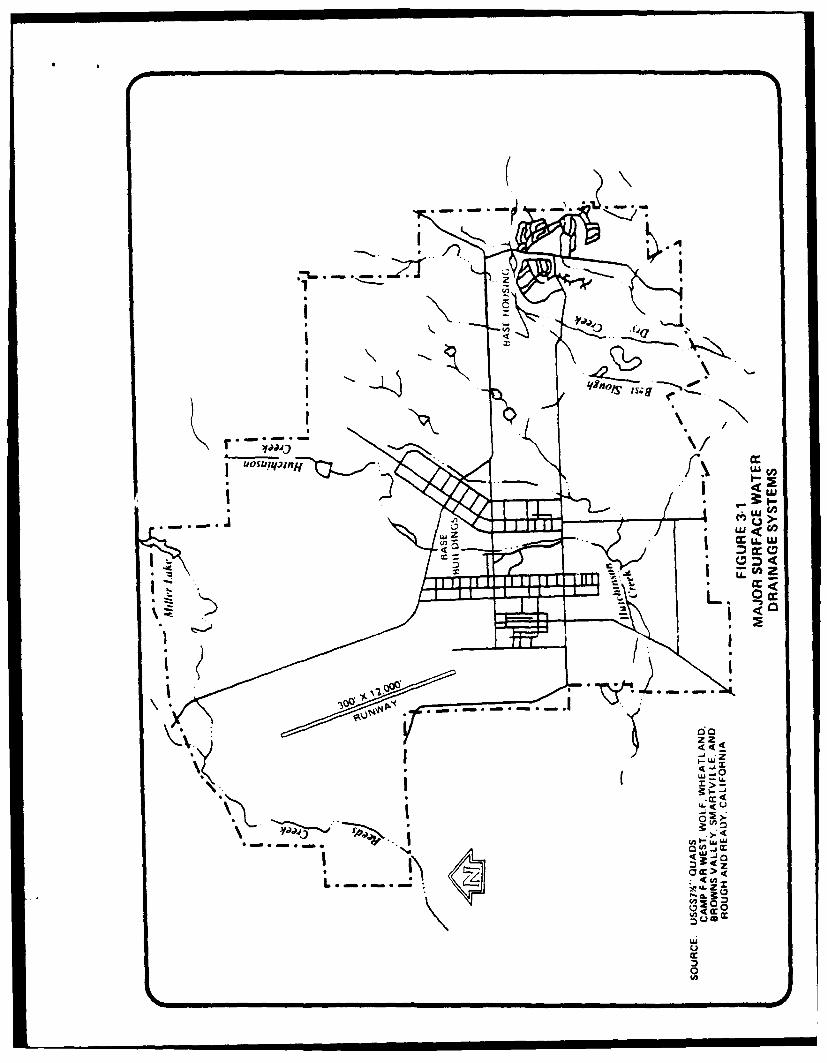
3.3.3 Surface Water Across Beale AB
Runoff from the base is collected and converged offsite by three
principal drainage systems. 7-nese drainage systems are Dry Cr-ek, Hutchinson
Creek, and Reeds Creek. With the exception of Dry Creek, these streams are
primarily intermittent (Figure 3-1).
Dry Creek originates to the east of the base and flows to the southwest
as Best Slough and Dry Creek. Parks Lake and Vassar Lake are part of this
surface drainage system. Dry Creek eventually discharges into the Bear
River.
Hutchinson Creek, which is the largest surface water system on the base,
flows mainly south on base, then flows west/southwest, and eventually joins
Reeds Creek. Upper and lower Bladmlder Lakes, Bedsprings Lake, Prisky
Lake, and Shingle Lake are part of the Hutchinson Creek drainage system.
Reeds Creek flows mainly west through the base from Miller Lake and
7/11/89 3-8
ru i
-.-
zz.I
* -U. Z
E0
generally parallels the northern base bounrdary. RLads creek and R hutir.on
Creek joinA before they drain into Plumas Lake soutwest, of the base.
Because of impervious soil onditions, lack of topographic relief and
infrequent but sometimes heavy precipitation, the streams in the western
portion of the base exhibit wide floodplain areas.
Both the Flightline and the Cantrmment Areas drainage is collected byHutchinson Creek and its tributaries. Surface runoff f the Family Housing
Area is collected by unnamed tributaries to Dry Creek.
3.4 BIOI=GI(•L R
The existing biota were evaluated by a combination of literature
reviews, contacts with biological experts, and discussions with base person-
nel. Ectensive interviews were cmrbaucte to identify sensitive species known
to ocr on the base. In addition, Mr. Robert Holland of California Depart-
ment of Fish and Game (CDFG) was contacted to determine if there were any
records of State-listed plants occurring on at Beale AFB. Mr. Jim Jokerst, abiologist at Jones & Stokes, who conducted a springtim botany and wildlife
survey for a proposed railroad line aaross the base, was also contacted inorder to determine the presence of any sensitive species. The National
Wetlands Inventory maps of Beale AFB were examined to determine if any
wetlands had been previously identified.
3.4.1 Sensitive Species and Habitats on Beale AFB
Beale APB Otain extensive open space and a variety of native
habitats. The latter include various ponds, freshwater marshes, oak wood-
lands, riprian woodlands, streams, and vernal pools. Vernal pools are quite
extensive west of the existing runway and contain plants included in the
California Native Plant Society (CNPS) rare plant inventory. A base-widewetland inventory was conducted in 1985 by U.S. Department of Agriculture,
Soil Conservation Service (USDA SCS). During this survey, all wetlands
(including vernal pools) were classified and mapped. In addition, the
potential ocoarrei8 of any OCPS-listed plants were evaluated. Although
several CMPS-listed plants are present in vernal pools on the base, no plants
7/11/89 3-10
i I II I I
listed as threatened or endangered by the State or Federal governmmnt are
known or expected to occur in other wetland or upland habitats an Beale AFB.
similarly, no wildlife species listed as threatened or erndaqered by the
State or Federal goverrnment are expected to occur on Beale AFB. However, the
pcds on the base provide a seasonal habitat for migratiuq waterfowl, and the
open grasslards provide a seasonal habitat for raptors.
Several federally listed bird species could occur at Beale AFB as
vagrants on rare occasions for brief periods of time, ircluding the Aleutian
Canada rose, peregrine falcon, and bald eagle. It has been speculated that
the endangered valley elderberry longon, beetle could ocar on the base;
howver, there are few elderberry trees present to provide suitable habitat.
3.4.2 FlijchLtMAr
This area consists of gently rolling annual grasslands dcminated by a
variety of native and introducd grasses including wild oats ( sp.),
barley (Hordsum sp.), and lolium (•lium sp.). Several spring flowering
herbs were also observed, including brodeia, wild hyacinth, and vetch. No
shrubs or trees were present. The grassland appeared ungrazed and relatively
urdisturbed.
Several vernal pools (8 or 9) occur in the northern portion of this
area, ranging in size from 20 by 20 feet to 150 by 50 feet. The pools were
readily recognized due to the absence of grasses in the center and the
pr a of coyote thistle ( y ) in the pools. Oumpared to
the pools located in the extensive grasslands west of the runway, the pools
near this site are ily snaller and of poorer quality.
The above pools my contain CNPS-listed species that could only be
detected during a spring botanical survey. No listed or otherwise sensitive
plant or wildlife species is expected to occur in this area.
3.4.3 CaU*t i AMea
Generally, land in this area has been previously graded or otherwise
disturbed. Introduced grassland or turf vegetation is predominant. No
7/11/89 3-11
XXx •xD FCEA
vernal pools are present, nor are any sensitive plant or wildlife species
present. One potentially sensitive habitat is a small grove of cottcmuods
within 200 feet of Hutcinson Creek.
3.4.4 Family iFkuri Aeas
This area consists of rolling hills dominated by arnnal grassland.
There are several drainages that traverse the site. Hwever, no riparian
vegetation is present except for five or six small and degraded willow trees.
No vernal pools are present, nor are any sensitive wildlife species likely to
occur at the site.
3.5
3.5.1
Noise is one of the byproducts of our society and is produced by a
number of sources. The major haaracteristics of noise are: intensitymeasured in decibels (dB), frequency measured in cycles per secod (Hz), and
duration measured in time (hours, minutes, or seconds). Himan reaction to
noise is affected by all three of these factors. In the case of aircraft,
engines generate vibrations in the air that are transmitted to the human ear
and interpreted by the brain as noise. Generally, the most troublesome noise
occurs at a high-pitched frequency, perceived as laud, and that occurs over
long periods of time. Some typical sources of noise and the levels produced
are shown in Figure 3-2. Measurement of noise levels are explained in
Appendix A.
3.5.2 Edstirz Noise .... #.
Noise contours (lines conr•etir points of equal aircraft noise) for
Beale AFB are based on average busy day existing and planned future levels of
activity and the assumgtion that future military aircraft will not be noisier
than existing military aircraft. Additionally, these are peacetime levels of
activities. Figure 3-3 presents CNEL noise contours at Beale as reported byScerýt rdE~ArEw Covo,&,f ;;fFA(SX• in 1987. Based on studxes of noise, the State of California has
established noise standards in the California Administrative Qode, Title 21,
7/11/89 3-12
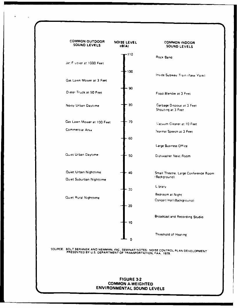
COMMON OUTDOOR NOISE LEVEL COMMON INDOORSOUND LEVELS dBIA) SOUND LEVELS
- -110Rock Band
Jet, F vover at 1000 Feet
-- 100Inside Subway Tran iNew York)
Gas Lawn Mower at 3 Feet
- •90Dieses Truck at 50 Feet Food Blender at 3 Feet
Noisy Urban Daytime - - 80 Garbage Dsciosai at 3 FeetShouting at 3 Feet
Gas Lawn Mower at 100 Feet - 70 Vacuum Cleaner at 10 Peet
Commercial Area Normal Speech at 3 Feet
- - 60
Large Business Office
Quiet Urban Daytime - - 50 Dishwasher Next Room
Quiet Urban Nighttime -40 Small Theatre. Large Conference Room
Quiet Suburban Nighttime (Background)
L brarv- 3 0
i Bedroom at NightQuiet Rural Nighttime Concert HallIBackground)
-20
Broadcast and Recording Studio
- 10
Threshold of Hearing
SOURCE. BOLT BERANEK AND NEWMAN, INC.. SEMINAR NOTES; NOISE CONTROL PLAN DEVELOPMENTPRESENTED BY U.S. DEPARTMENT OF TRANSPORTATION, FAA, 1979.
FIGURE 3-2COMMON A-WEIGHTED
ENVIRONMENTAL SOUND LEVELS

1 MA0 1 2 Miles LOMA *ICA I o M
J&PU CIO Is
USA co 10 AfEAELE COLIJAS
PAMINEZ 140
splowNsVALLEY
000 u
A ILLE
:t IF iftz 1
R svi 0 2
LINDATH OE LF o
AM ct a 1E
RCA
0 VE"u
0
65 75CAMP FAR IVEST
RES
HEATes
A
S
LEACH 010
it
ale
SOURCE. SACOG. 1987
FIGURE 3-3NOISE CONTOURS
XXK/X)= CE
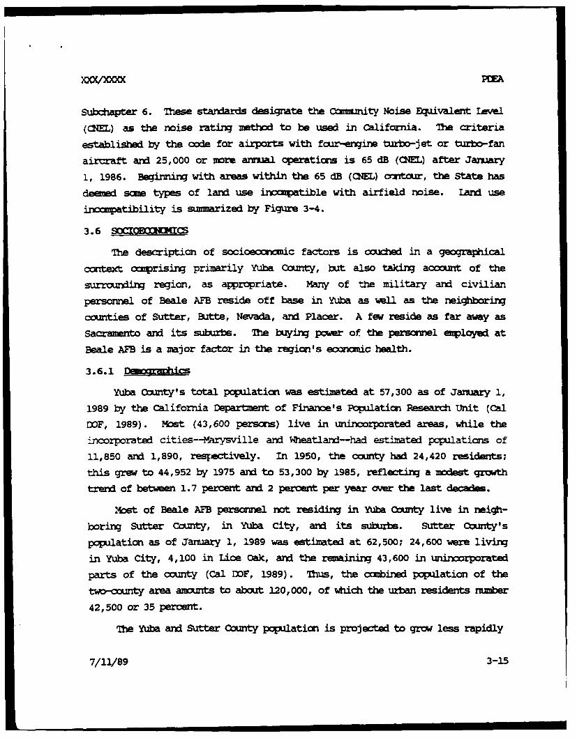
Subchapter 6. Thse standards designate the oummnity Noise Equivalent Ievel
((fL) as the noise rating mthd to be used in California. The criteria
established by the code for airports with four-engine turbo-jet or turbo-fan
aircraft and 25,000 or more annual operations is 65 dB (CNEL) after January
1, 1986. Beginnirn with areas within the 65 dB (CNEL) om*it, the State has
deemed sma types of land use 2 tible with airfield noise. Land use
incompatibility is summarized by Figure 3-4.
3.6 SOCI ( CS
The description of socioeoc factors is couched in a geographical
context comprising primarily Yuba County, but also taking account of the
surroudig region, as appropriate. Many of the military and civilian
personnel of Beale AFB reside off base in Yuba as wall as the neighboring
counties of Sutter, Butte, Nevada, and Placer. A few reside as far away as
Sacramento and its suburbs. The buying power of the persormel employed at
Beale AFB is a major factor in the region's economic health.
3.6.1
Yuba County's total population was estimated at 57,300 as of January 1,
1989 by the California Department of Finance's Population Research Unit (Cal
DOF, 1989). Most (43,600 perscrE) live in unincorporated areas, while the
incorporated cities--Marysville and Wheatland-had estimated populations of
11,850 and 1,890, respectively. In 1950, the ounty had 24,420 residents;
this grew to 44,952 by 1975 and to 53,300 by 1985, reflecting a modest growth
trend of between 1.7 percent and 2 percent per year over the last d .
mst of Beale AFB persormel not residing in Yuba Cnty live in neigh-
boring Sutter County, in Yuba City, and its suburbs. Sutter Comty' s
population as of January 1, 1989 was estimated at 62,500; 24,600 were living
in Yuba City, 4,100 in Lioe Oak, and the remaining 43,600 in unincorporated
parts of the county (Cal DOF, 1989). Thus, the cambined population of the
two-county area amonts to about 120,000, of which the urban residents number
42,500 or 35 percent.
The Yuba and Sutter County population is projected to grow less rapidly
7/11/89 3-15
GENERALIZED LAND USE CNEL (dl)
CATEGORY 55 60 65 70 75 80 85
I RESIDENTIAL
2- MANUFACTURINGOFFICE AND PUBLIC AREAS
OTHER AREAS
3- TRANSPORTATION. COMMUNICATIONS.& UTILITIES
OFFICE & PUBLIC AREAS
OTHER AREAS
4- TRADE, BUSINESS, & OFFICES
5- SHOPPING DISTRICTS
6. PUBLIC & QUASI-PUBLIC SERVICES
7. RECREATION
8- PUBLIC ASSEMBLY
9- AGRICULTURE & MINING
KEY: SOURCE. Develooed from Information SACOG, 1987
-- COMPATIBLE
COMPATIBLE WHEN INTERIOR NOISELEVELS ARE REDUCED TO THE45- 50 dB RANGE
1 NOT COMPATIBLE
FIGURE 3-4STATE OF CALIFORNIA
LAND USE COMPATIBILITY FOR AIRCRAFT NOISE
than the state as a whole over the next several years. From a base of
115,400 at July 1, 1987, the population is expected to rise to 129,000 by
mid-1995, an average increase of 1.4 percent per year.
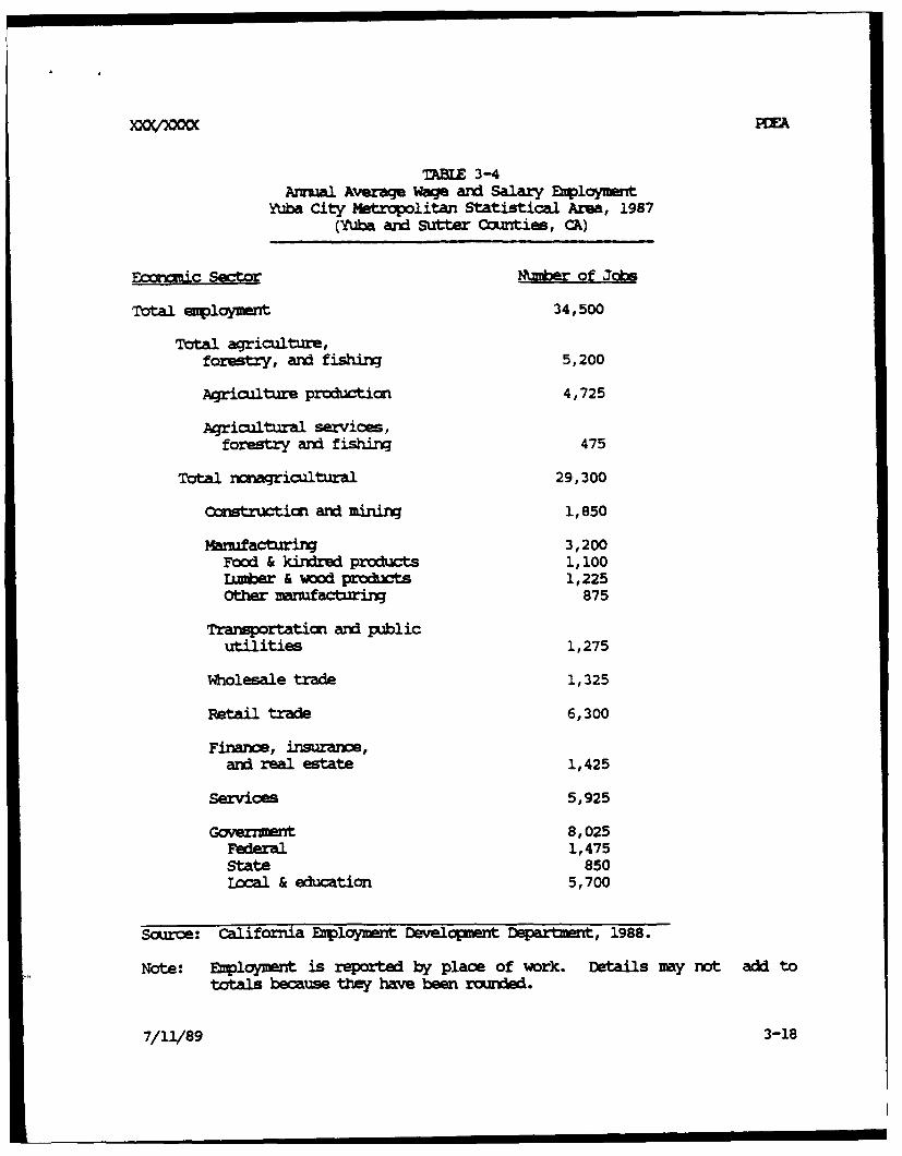
3.6.2 E -gymic
Beale AFB lies in the Yuba City mtrpolitan Statistical Area (MA),
which is composed of Yuba and Sutter Counties. The combined population of
the two ccunties in 1989 was 119,800, as estimated by the California
Department of Financ in 1989. The resident civilian labor force for Yuba
City MSA was 44,700 in 1987, of which 39,450 ware employed :n the MSA and
elsewhere, while 5,250 (11.7 percnt) were urneployed (Cal EMO, 1988). The
average annual wage and salary employment provided by Yuba City MSA-based
enployers totaled 34,500 in 1987, inKiicating that several thousand working
residents of the region ware employed away from the MSA. The structure of
employment in the Yuba City MA reflects a diversified econcoy restin on a
strong base of agriculture, manufacturing, commerce, and governmnt. Table
3-4 provides the composition of wage and salary employment for the Yuba City
MSA in 1987.
The California Employment Development Depart•nt projects modest growth
of euployment in the Yuba City MSA. Between 1987 and 1989, Cal EM estimated
that total wage and salary enployment in the region would increase by about
850 jobs, or about 2.5 percent. The retail trade sector was expected to
experience the largest increase of any sector during the period-about 250
jobs. Next strongest are services (+200 jobs) and govenmnt (+150) jobs, of
which the latter would be due entixely to growth of State and local
government employment (Cal EDD, 1988).
Yuba and Sutter Counties ware projected to have relatively slow
population growth rates compared to Placer and Nevada Counties. Besides
these two latter counties, the other central foothill counties and those
around Sacramento are all projected to grow more rapidly than Yuba and Sutter
in the near future (OCC, 1988), implying greater enployment oppmrtumities.
Similar projections hold for the growth of personal inome in the area. Over
the longer term, however, the area cild suport stronger growth beause of
7/11/89 3-17
"TABLE 3-4Annual Average Wage and Salary Eip~lymet
yUba City Metrpolitan Statistical Area, 1987(Yuba and Sutter Counties, CA)
•rauic Sect= N1mber of Jobs
Total euploymnt 34,500
Total agriculture,forestry, and fishing 5,200
Agriculture production 4,725
Agricultural services,
forestry and fishirn 475
Total nonagricultural 29,300
Construction and mining 1,850
Manufacturirn 3,200Food & kindred products 1, i00LUmber & wood prodxwts 1,225Other manufacturinr 875
Transportation and publicutilities 1,275
Wholesale trade 1,325
Retail trade 6,300
Finanie, insuranze,and real estate 1,425
Services 5,925
Government 8,025Federal 1,475State 850Local & education 5,700
Source: California Employment Development Department, 1988.
Note: EIployment is reported by place of work. Details may rot add tototals because they have been rounded.
7/11/89 3-18
its ample supplies of water and devel•pable land, comparue to its neighbors
to the scq.th, which are already experiencxin pressure on public services
and husinq costs.
Personal income levels in the Yuba City msA have been lower, on a per
capita basis, than the statewide averages. In 1987, the per capita incomefor the MSA was $12,158 (total personal inoe tor the region agregated to$1,408 million) compared to the statewide average of $17,841. The statewideaverage breaks down into a metropolitar portion average of $18,044 per
capita, and a =metropolitan area average of $13,299 per capita. On thislatter basis, the Yuba City 's per capita irx is close to the statewide
nomatitrpolitan area average (BEA, 1989).
The Beale AFB Arnal Report FY 1988 Economic Resource Impact Statemnt
(ERIS) indicates that the base had a total of 4,642 personel directlycoxeted with host and tenant activities in FY 1988, of wnm 4,142 weremilitary and 500 were civilians. An additional 748 civilian and contractor
perscnnel were employed in the Base E wige, private on-base business, andcontractor assignments. Personmel living on base totaled 6,232 persons(2,601 military and 3,631 dependents). Off-base personnel numbered 1,541military and 1,512 dependents, plus the 1,248 civilians noted above, for atotal of 4,301 persons (Beale AFB 9th S1W/AOC, 1988).
The ERIS estimates that the total military and civilian payrolls in FY
1988 ware $104.62 million, of which about $58.6 million was spent off base ina 50-mile radius 'Eic c Impact Region." In addition, norpayrollexpenditures amounted to over $40 million ($25.1 million for constriction
activities, plus $15.4 million for services and supplies procurement). Theselatter nY ayroll expenditures were mainly to local vendors, withapproximately $31.1 million being spent in the Eonomic Impact Region (EIR).The cumulative impact of the spending within the 50-mile radius EIR,considering multiplier effects on the regional ecrnamy, was estimated at
$258.7 million, with secordary job creation due to the infusion of new incomgenerating an additional 1,732 jobs in the region (Beale AFB 9th SRW/ACC,
1988).
7/11/89 3-19
S~PMA
The Hzsing Assistance Office (9th CSG/IUM) of Beale AF prepared a
"CiviliarVnMilitary Locator Rqxot" during November/Deeker 1988. The report
coumted 4,183 military personnel aid dependents, of which 1,411 were livirn
off base within the 50-mile EIR. An additional 494 civilian employees of
host and tenant operations were accounted for, living within a 50-mile radius
(including 56 on base). The vast majority of the off-base military personnel
(and their dependents) live close to the base: 1,177 (83 percent of the
1,411 livirn in the 50-mile radius EIR) live in Marysville, Yuba City, Penn
Valley, and rx amtlara (and their suburts), with the next larget oTtingent
(about 125) living in Sacramento and its suburbs. Similarly, amon the
civilian employees residing off base (449), mst (319 or 73 percent) live in
nearby Marysville, Yuba City, Penn Valley, and Wheatland.
From these data, it is evident that the bulk of eonmic stimulus from
oonsution spending by Beale AFB personnel and civilian mployees aocr to
Yuba and Sutter Counties. Secondary effects radiate to the larger central
California region throh operation of employment and income multiplier
effects.
3.7 Air
3.7.1 Base Faiities
The base has one active corxrete runway, which is 12,000 feet long and
300 feet wide. There are asphalt overruns of 1,000 feet on the south and
2,250 feet on the north. Ihe runway is capable of handling any aircraft in
the Air Force inventory.
The Air Force maintains 3,000 foot by 3,000 foot clear zones at each end
of the runway, a 1,000-foot safety zone on each side of the runway center
line, a 200-foot safety zone from the center of each taxiway, aid a 125-foot
minimum safety zone from outside the aprons. Hazardous cargo pads are
located at the base, with a 1,250-foot safety distance required betweei
hazardous cargos and inhabited stctures.
Navigational aids include high-intensity runway lights, high-intensity
approach lightirn, Visual Approach Slope Indicator (VASI) lights, Solid-State
7/11/89 3-20
mnstnmnt Lad.ring System (SSflS), FAA's Area Surveillance Radar (ASR)
station, Marysville's VHF Omni-Range and Tactical Navigation Station
(VOMrZMC), and UH trammitters and receivers.
3.7.2 FlUrKT(JM
Flying operations at Beale include three types of relKraissarce
aircraft, aerial refueling aircraft, and four types of training aircraft. On
average, there are 173 takeoffs per day from Beale. From 1978 to 1985,
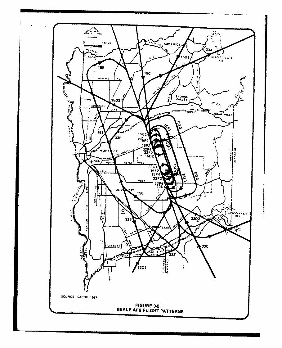
annual aircraft operations have averaged 103,544. Flight patterns used are
presented in Figure 3-5 and explained in Table 3-5. SR-71 aircraft average
six takeoffs each day and represent an average of three percent of all
takeoffs at Beale. Additionally, a portion of T-38 and KC-135 cperations are
in direct support of the SR-71 program. The total average daily takeoffs of
T-38 is 68 or 39 percent of all takeoffs. For KC-135 there is a daily
average of 27 takeoffs or 16 percent of all takeoffs.
Traffic patterns for Beale AFB are established according to Air Force
directives, with safety and noise abatement ccrsideraticns foremst.
Prevailing winds are from the south about 90 percent of the time; thus, the
majority of takeoffs are toward the south. The majority of the flying
activity takes place east of the airfield and is regulated to a southeasterly
flow. This means that most takeoffs are toward sparsely populated rural
areas in Yuba and Placer counties. The northern patterns also fly over
sparsely populated areas.
Flying operations are coordinated with the Federal Aviation
Administration (FAA), and flight paths are integrated to minimize conflict
with civilian aircraft operations at Sacramento Metropolitan Airport, Yuba
County Airport, Sutter County Airport, Lincoln Air-yrt, and with military
operations at McClellan Air Force Base.
Use of airspace around Beale AFB is controlled by the Federal Aviation
zministratian (FAA). In the Sacramento area, responsibility for control of
terminal airspace lies with five local air traffic control (ATC)
tower.*ocated at Metropolitan and Ex•c•tive Airports, and at McClellan AFB,7 8t
7/11/89 3-21
#
2 moes 1"". LOMA olIC&
33A
o" C, 1501 '0fRfLfCozz1,-T
PCs
ISE
15c
z
BROWNS
1502 -c VALLEY47
z LAE
ARTvILLE
lop15E 1502
33E15F4
ISF233F4 op
%f-%R%'S LLE 33F215D2
KAOMLIND yn"T REALf QýA:) at
375 1
IMLE 5F2 BISF433F2 033F4
33DOLIV &T
ISE
z
W F4 0 1, CSr% Rfs
'Z 3 3302
H T L AN
LEACM 010 33C
8 A it F00
33E
2
3301
SOURCE SACOG. 1987
FIGURE 3.5BEALE AFS FLIGHT PATTERNS
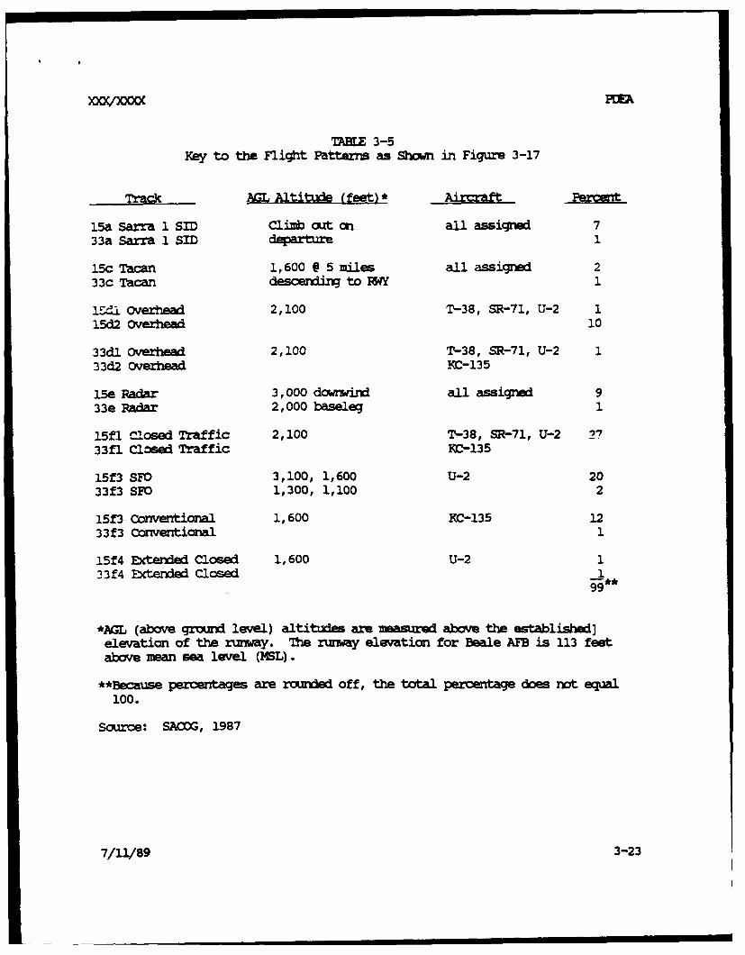
TABE 3-5Key to the Fligt Patterns as Shown in Figure 3-17
Track AGL A1titude (feet) *
15a Sarra 1 SID Climb out on all assigrnd 733a Sarra 1 SID departure 1
15c Tacan 1,600 @ 5 miles all assigned 233c Tacan descendin to PW 1
I"-'i Overhead 2,100 T-38, SR-71, U-2 115d2 overhead 10
33dl Overhead 2,100 T-38, SR-71, U-2 133d2 Overhead KC-135
15e Radar 3,000 downwind all assigned 933e Radar 2,000 baseleg 1
15fl Closed Traffic 2,100 T-38, SR-71, U-2 2733fl Closed Traffic MC-135
15f3 SFO 3,100, 1,600 U-2 2033f3 SFO 1,300, 1,100 2
15f3 Conventional 1,600 KC-135 1233f3 Conventional 1
15f4 Exterded Closed 1,600 U-2 133 f4 Extended Closed 1
99
*Am (above ground level) altitudes are measured above the established]elevation of the runway. The runway elevation for Beale AFB is 113 feetabove mean sea level (ML).
**Because percentages are rounded off, the total percentage does not equal100.
Scurce: SACOG, 1987
7/11/89 3-23

Mather AFB, and Beale AFB. Responsibility for transitional area airspace
lies with the Terminal Radar Approach Cntrol Facility (UAtCO) located in
Sacraento. The Air Route Traffic C itrol (AR1U), located in Fremont, is
responsible for enzr=te airspace.
Aircraft arriving at or departin from Beale AFB generally follow
Standard Terminal Arrival Routes (STRs), Standard Instrumt t rtures
(SIDs), and low-altitude airways. SI•Rs provide for a transition between the
enrcute phase of a flight and the beginning of the instrument approach, while
SIDs provide for the transition between departure and the enrute phase.
Aircraft not using STARs and SIDf use identified low-altitude airways.
The local low-altitude airway structure is identified by reference to the
Sac II MW =ui-Range and Tactical Navigational CVRC=) facility
located in east Yolo County.
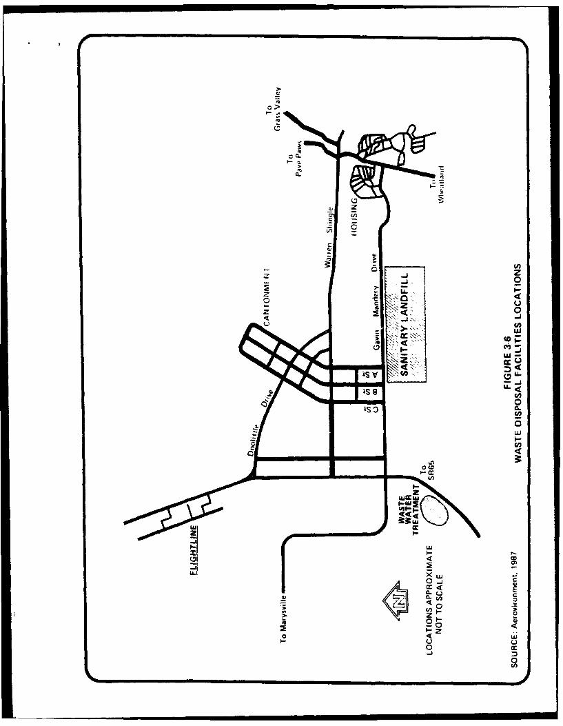
3.8 Waste Di
3.8.1 Solid Waste
Solid waste from base perations and households is disposed in a
sanitary landfill located on the southern portion of the facility, betwn
the Cantormw't Area and the family Housing Area. Vehicles enter the landfill
from Gavin Mandry Road. Figure 3-6 presents the location of waste disposal
facilities on Beale AFB.
This landfill, occupying about 40 acres, has been in use since 1981, and
is permitted by the State as a Class III (nmohazardous) landfill. Waste
deposited there is primarily general refuse. Cperations here consist of
trench method disposal. Water run-cn and mmn-off controls are present.
Management practices include no chemical disposal and covering the waste
daily (Aerovironrnent, 1987).
This landfill was investigated under the Installation Restoration
Program in 1985 through 1987. It was found to cause no enviroumental
contamination.
7/11/89 3-24
0 >
QU
CL,
LU
0ISO -L
cUcw
CM-a-
4<4
!1 -LLU cc
I.-
Ca,
0 -
CL U E
00
000
U LU0
0
3.8.2 WN&NMI= and Se-qO
The entire base, except the Fliotline Area, is served by a gravity flow
sanitary ser system. Lift Station No. 5/9 is the main lift station serving
the Flightline Area. All sanitary sewer flow is delivered to the Beale AFB
Sewage Treatment Plant (STP), where it receives primary and secoary
treatment with aeration. The SrP has a sustained capacity of 5 million
gallons per day and presently peaks at an averae flow of 1.45 million
gallons per day. During periods of heavy rain, storm water infiltrates the
sanitary sewer system and at tie causes a mr1-er =-edition if operators
do not rater flow into the plant by backfilling the sanitary lines (PAT,
1989).
During summer months, the aerated secodary effluent is used to water
the golf course; otherwise it is discharged to iutchinson creek. The
California Regional Water Quality Citrol Board (ORCB) issued a National
Pollution Discharge Elimination System (NPEES) permit to Beale AFB to
discharge their treated wastewater. A osase-and-desist order has been issued
by the CICB requiring Beale AFB to brinm its watewater discharge into
compliance with the requirement of their permit (O'Haire, 1989).
7/11/89 3-26
4.0 ENV1 UFORO .L FK4MNM OF 7W PFCFCEZ AC•IC
4.1
This section provides an evaluation of potential environmental cose-
quences that would occur as a result of implementation of the proposed
action. Cmuulative impacts from this proposed action and an unrelated
proposed action to relocate the SUNr at Beale AFB fr nearby Mather AFB will
be addressed in a separate EIS being prepared to assess potential impacts
related to the SUNT move.
4.2 ( '=170 THE - MICAL AND H30A ENV•IMV 4
4.2.1 AirR ces
Regional and local air quality will not be adversely impacted by
impl•mentation of the proposed action. Deactivation of the SR-71 progrm
will eliminate a small percentage of existirq aircaft activity at the base,
and air emissiors associated with SR-71 program flight activities will not
occur. This would result in a small, but beneficial impact to local and
regional air quality.
4.2.2 Water Rcnzrs
Deactivation of the SR-71 program at Beale AFB will not impact ground-
water or surface water resources at Beale AFB. Accidental fuel spillage
and subsequent contamination of adjacent drainage areas south of the existing
ruIway that has previously occurred through norual SR-71 operations will not
continue to occur. Implmentation of the proposed action should result in an
overall impr to local water resources on this portion of the base.
4.2.3 BolcMical
Terrestrial and aquatic resources at Beale AFB will not be impacted as a
result of the proposed action. Existing grassland and riparian habitat along
drainages south of the existing runway that have been previously affected by
contaminated surface runoff from the runway area as a result of SR-71
7/11/89 4-1
operations will not continue. This will result in an overall in~rovarnt to
the quality of those habitats in this portion of the base.
4.2.4
No adverse inpacts will occur as a result of the prcposed action. Deac-
tivation of SR-71 aircraft at Beale AFB will result in a mall, urquantified
reducticn in noise levels generated fran normal base operations. Hdxvver,
redchticns in overall noise as a result of deactivatirn the SR-71 prora are
not expected to significantly reduce the aerial coverage affected by noise
levels greater than 65 Ldn as shamn on Figure 3-3.
Beale AFB received approximately 217 noise oamplaints during 1988; 95%
of which were directly attributed to SR-71 operations (Captain Ronquillo,
Personal Couminications, 1989). These oceplaints originated from different
areas across the western portion of the United States in the vicinity where
SR-71 flight training patterns have been established. These coiplaints were
usually the result of sonic b-!zs generated by the SR-71 during flight
trainirx exercises. The deactivation of the SR-71 program would eliminate
the major contributor of noise ocuplaints received by Beale AFB and sonic
boams over the western United States as a result of cessation of SR-71 flight
training exercises.
4.2.5 Socio ics
Inplmentaticn of the proposed action will result in the elimination of
approximately 619 positions at Beale AFB currently occupied by a cambination
of officer, enlisted and civilian, persoa l. Officer and enlisted personel
will be transferred to other WSAF installations or to other functiccs
currently operating out of Beale AFB. It is anticipated that up to 38
civilian jobs my be lost as result of the proposed action. This loss in
civilian job opportunities represents an insignificant adverse iurpact to the
local and regional econic base.
It should be noted that relocation of the SUNT to Beale AFS fram nearby
mather AFB as a result of the no -iines r. -idaticxu for base
realigriit and closure is expected to create proxitely 1677 now employ-
7/11/89 4-2
i i a
ent oem ortunities at Beale AFB, 171 of which are expected to be held by
civilian persorrel. This is anticipated to more than offset the loss of
civilian employment opportunities associated with the deactivation of SR-71
program.
4.2.6 Air
The deactivation of the SR-71 program at Beale AFB will reduce air
traffic at and in the vicinity of the base by more than three percent.
Reductions in air traffic will enhance overall air safety since oportunity
for aircraft accidents will be reduced. Therefore, the deactivation of the
SR-71 program will help to iprove air safety in and around Beale AFB.
4.2.7 Wastl
A reduction in solid and liquid waste will result fr- the proposed
action since waste currently generated by operation and maintenance of the
SR-71 program and associated support activities will no lconer be generated.
Therefore, deactivation of the SR-71 program will have an overall positive
impact on waste disposal.
4.3 I"(M a 1
No mitigation measures are required for the proposed action. The loss
of military and civilian employment opportunities will be more than offset by
an unrelated proposed action to relocate the SUNT to Beale AFB. This
cumulative impact is being addressed in a separate EIS document specific to
the SUNT relocation.
4.4 ADVEMSE EFFEM MWT @Wr B AVOII IF TW 1F1F_ ACflI ISIY-
The only unavoidable adverse inpact that cannot be avoided as a result
of implemntation of the proposed project would be the loss of approximately
619 military and civilian positions. Military persconl will be either
transferred to other USAF installations or assigned to other functions at
Beale AFB. The loss of about 38 civilian eaployment oportunities is
"7/11/89 4-3
XM0OQ= PC~h
expected to be insignificant with respect to the local and regianal eccrmic
base. In additian, an unrelatAd proposed action to relocate the SU?1 to
Beale AFB will create about 171 now civilian jobs at Beale APB and should
more than offset the loss of civilian euployzmit cortunities related to the
deactivation of the SR-71 program.
4.5 IEWv s E1 1 AND n -D IEV12 OF I _-
No irreversible and irretrievable commitment of land uses or natural
resources is expected to occur as a result of the deactivation of the SR-71
program.
4.6 RE.ATTICH P BiWMi Sw USS AND TCHG TIMIVIw
Inplmetwation of the prposed action is not expected to result in any
long-term adverse impacts on the productivity of the envirt. cing
SR-71 facilities that will no lorner be needed under the current program
(harners, mintenanc and operating facilities, pipelines, fuel tanks) will
becam available for other ccmpatible uses.
7/11/89 4-4
5.0 SaMM P Fn0DIM
The proosed action is not expected to have significant adverse impactson the enviroxmnt, nor is it anticipated to be envircnztallycontrOversial. Therefore, a detailed envriroimnta impact statiannt is notconsidered r*Ck*ry, and d FindIq Of No Significant Impact (FtSNI) shouldbe issued.
7/11/89 5-1
-- , i i I II| I I

*I'flu'1093 PTEA
6. 0 laEW
Aerovirmment, Inc., May 1987. Installation Restoration Pr = Fhase II-
confir•ation/Ouantificatian Stage 1 Final Reort for Beale Air Force
Base. Marvuville. California.
Air Force Reaulatior 19-2.
Beale Air Force Base, 9th SIW/ACC, 1988. Beale Arnal Rwort FY 1988,
Ecormc RPe-srce ct statn .
Beale Air Force Base, Hawsing Assistanc Office, 9th CSG/MV,
November/ ce 1988. Civilian/Military Locator .
Bolt, Beranek and Newman, Inc., 1979. Saminar Notes: Noise Control Plan
Devel , present by the U.S. Department of Transportation, FAA.
Bureau of Eonmic Analysis (BEA), U.S. qpartment of Commrce, April 1989.
Survey of Current Buss , Vol.69, No.4.
California Air Resaiazes Board (CARB), Technical Support Division Emission
Inventory Branch, Deeer 1986. Emission Inventory 1983.
California Departnt of Finance, DEgrapfuc Research Unit, (Cal IOF), May
1989. Population Ftimate of California Cities and Counties. Januarv
1,1988 to JanIary 1. 1989. Report 89 E-1.
California Employment Development (Cal EDt), May 1988. Annual Plannin
Information: Yuba City Metropolitan Statistical Area (Sutter-Yuba
Count). 1988-1989.
Center for Continuing Study of the California Econcuy (CCSCE), 1988.
California Cmttv Projections. 1988 Edition.
7/11/89 6-1
)'OMuiana PCEA
RE -4, continued
Code of Federal Remulatiors, Section 40 Part 1500-1508, November 1978.
EDAW, Inc., 1988. Draft Base Coahpebensive Plan for Beale Air Force Base,
O'Haire, Karen, California Regional Water Quality Control Board, letter to
Idh Stirts, U.S. Department of the Air Force of March 21, 1989.
Planning Assistance Team (PAT), Manrc 1989. Base Realigmryt Sitig Analysis
for peal. Air Force Base, California. Air Force Regional Civil En-
gineer, Western Region, San Franisco, CA.
Sacr-mnto Area Council of Governments (SAMG), June 1987. Beale Air Force
BaM Cawrehemsive Land Use Plan.
U.S. Deparment of Agriculture (TSDA) Soil Conservation Service, 1985. Beale
Air Force Base. Interim Soil Survy.
U. S. Envi=rmnta1 Prtection Agency (USEPA), Office of Air Quality Planning
aid Standards, 1977. Guidelines for Air Quality Maintenance Plann
and Analysis Volume 10 (Revised) : Procedures for Evaluating Air ualaity
ImDact of New Stationary Sourc. Publication No. EPA-450/4-77-001.
Research Triangle Park, North Carolina.
U.S. Geological Survey, 1973. CaImp Far West. California 1:24,000 topographic
quadrarnle.
U.S. Geological Survey, 1973. Wolf, California 1:24,000 topographic
quadrangle.
7/11/89 6-2
* bm
R W , cuntinut d
U.S. Geological Survey, 1973. Wheatland, California 1:24,000 topographic
quadrangle.
U.S. Geological Survey, 1973. Browns Valley. Californi 1:24,000 tcpographic
quadrangle.
U.S. Geological Survey, 1973. Smartville, California 1:24,000 topographic
quadrangle.
U.S. Geological Survey, 1973. Rough and Ready, California 1:24,000
topographic quadrangle.
7/11/89 6-3
A &
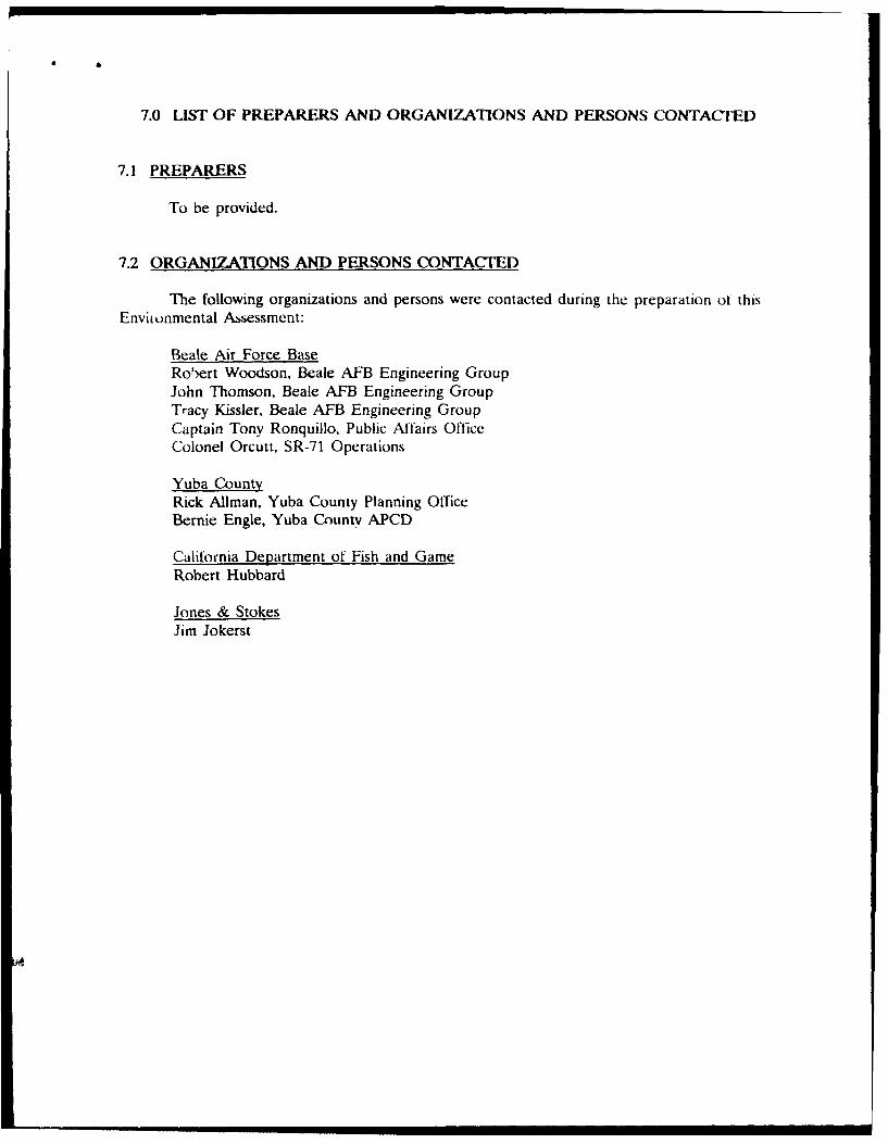
7.0 LIST OF PREPARERS AND ORGANIZATIONS AND PERSONS CONTACTED
7.1 PREPARERS
To be provided.
7.2 ORGANIZATIONS AND PERSONS CONTACrED
The following organizations and persons were contacted during the preparation ot thisEnviionmental Assessment:
Beale Air Force BaseRobert Woodson, Beale AFB Engineering GroupJohn Thomson, Beale AFB Engineering GroupTracy Kissler, Beale AFB Engineering GroupCaptain Tony Ronquillo, Public Affairs OfficeColonel Orcutt, SR-71 Operations
Yuba CountyRick Allman, Yuba County Planning OfficeBernie Engle, Yuba County APCD
California Department of Fish and GameRobert Hubbard
Jones & StokesJim Jokerst
APPEUINX A
•NOISE MEASUREMENT
•XXX/XXXX PCFA
AHP A
Definitions of Noise Measurs
Typically, noise measurements are expressed as dB, A-weighted sound
levels, day-night average sound levels (Ldn), or community noise equivalent
levels (CNEL). The meas•%mert scale used in community noise level evalua-
tions is the A-weighted sourd level, commnly called the A-level or dB(A).
It is measured in decibels to provide a scale with the rang~nd
characteristics most consistent with that of human hearing ability and
annoyance potential.-
To establish the A-weighted sound level, the acoustic signal is detected
by microphone and then filtered, heavily weighting those portions of noise
that are loudest when experienced by people. This weighting of sound energy
correspords approximately to the relative annoyance of human senses to noise
experienced at various frequencies.
The A-weighted sound level of traffic noise and other long-term noise-
producing activities within and aron the comm2nity varies considerably with
time. Measurements of this varying level are acomoplished by obtaining the
values of noise for a specified period of time. Tis yields the A-level
values of noise that are useful in assessing the potential annoyance of the
disturbance.
It is rrxxgnized that a given level of noise may be more or less
tolerable deendeir on the intensity, duration, and time-of-day of the
exposure experienced by an individual. The State Department of Aeronautics
and the California Commission on Housing and Comounity Development have
adopted the Ccmmunity Noise Equivalent Level (COEL) to account for peoples'
sensitivity to noise exposure. Tis measure considers the energy equivalent
sound levels for the evening hours (1900 hours to 2200 hours) and inceases
the noise measured during this period by 5 dB. An increase for the late
evening and mornirn noise levels (2200 hours to 0700 hours) of 10 dB is
applied. The daytime noise levels are combined with these weighted levels
and are averaged to obtain a CNEL value.
The maximm exterior noise exposure of noise-sensitive land uses should
not exceed an average day-night sound level Ldn of 65 dB. The tdn is
7/11/89 Appendix A-2
calculated by weighting noise betwenr 2200 hours and 0700 hours by 10 dB, aswith the CNEL. However, the noise level during the evening hours (1900 to
2200) is not weighted as it is in the CNEL. For practical purposes, the twomeasures agree to within 1 dB and are frequently used interchaneably.
Figure A-i presents some examples of In levels in common human enviraimnts.
7/11/89 Appendix A-3
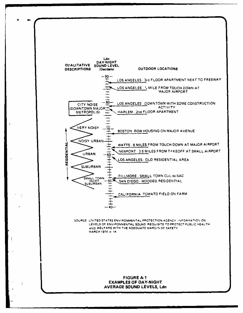
LdnDAY-NIGHT
QUALITATIVE SOUND LEVELDESCRIPTIONS (Decibels) OUTDOOR LOCATIONS
-90--. LOS ANGELES 3rd FLOOR APARTMENT NEXT TO FREEWAY
LOS ANGELES MILE FROM TOUCH DOWN ATMAJOR AIRPORT
CITY NOISE _90- LOS ANGELES DOWNTOWN WITH SOME CONSTRUCTION
I(DOWNTOWN MAJOR-- ACTIVITY
METROPOLIS) "'" HARLEM- 2nd FLOOR APARTMENT
VERY NOISYBOSTON -ROW HOUSING ON MAJOR AVENUE
NOISY URBAN---S< WATTS- 8 MILES FROM TOUCH DOWN AT MAJOR AIRPORT
z -,, NEWPORT- 3.5MILES FROM T- KEOFF AT SMALL AIRPORTu URBAN -60-'
SLOS ANGELES-OLD RESIDENTIAL AREALUJ
SUBURBAN
SMALLTOWN FILLMORE- SMALL TOWN CUL-de-SACQUIET -- 50b SAN DIEGO- WOODED RESIDENTIAL
SUBURBAN -
CALIFORNIA .TOMATO FIELD ON FARM
-40-
SOURCE UNITED STATES ENVIRONMENTAL PROTECTION AGENCY INFORMATIONJ ON
LEVELS OF ENVIRONMENTAL SOUND REQUISITE TO PROTECT PUBLIC HEALTH
AND WELFARE WITH THE ADEQUATE MARGIN OF SAFETYMARCH 1974. o 14.
FIGURE A-1EXAMPLES OF DAY-NIGHT
AVERAGE SOUND LEVELS, Ldn