Embed Size (px)
Citation preview

SCO
T
L
A
ND
ENGLAND
EastKielde
BellsburnfootKerseycleugh
Kielder
Deadwater
Kittythirst
Fairloans
Salmon CentreObservatory
Kielder
KielderCastle
.
.
.
.
.
Cat Cairn
Loch Knowe
B e w s h a u g h
Greys Pi
ThorlieshopePike
DeadwaterFell
360
571
403 445
355
Bells MoorRavenshill
MoorD
ead
wat
e
Bells
Bur
n
K
i eld
er
B
urnRiver N
orth Tyne
To Newcastletonand Jedburgh
Fore
st D
r iveC
200
P
P
P
P
l
l
Specere
Skyspace
Minotaur
Limitedaccess
BakethinNature Reserve
Skyspacecar park
Skellys Riggin
3 Dog Climb
Sharon’s Stone
Pincer
Daugie’s Day Off
Kersey Cleugh
Into the Valley
Jimmy’s HillUp & Over
For Peat’s Sake
Devil’s Elbow
Superbowl
All Along the Watchtower
Primrose WoodTwist & Shout
Rattle Snake
Adder NuffStumpy Hill
Forrest’s Dive
Snakebite on Black
Shake Rattle & Roll
Woodstock
Whacky
Ravens Hill
Start/Finish Kielder Castle Car Park
www.visitkielder.comDEADWATER MTB TRAIL
WHAT’S IT LIKE?
DEADWATER TRAILS
TRAIL START Kielder Castle car park
TRAIL FINISH Kielder Castle car park
TRAIL LENGTHRed - 4.2miles/6.8kmBlack - 4miles/10.2km
TRAIL GRADE Red Difficult Black Severe
Safety information and full Kielder Water & Forest Park map overleaf »
N
W E
A road
B road
Minor road
Other road
Main track
Other tracks
MTB cycle trail(on Lakeside Way, public road orforest road)
MTB cycle trail(singletrack)
MTB uphill section
MTB downhill section
Line of old railway(disused)
National border
National Parkboundary
Ferry
Car park
Visitor information
Toilets
Refreshments
Bike hire
Camp site
Youth hostel
Art / Architecture programme
ViewpointM(sM(s
M(M(
MAP KEY
Deadwater red grade trail is a cross country trail on the lower slopes of Deadwater Fell. The trail is packed with features including awesome fast sections of singletrack mixed in with some tricky rocky sections.
Deadwater black grade trail includes the Skellys Rigging section, this part takes in the breathtaking Deadwater Summit. On a clear day you can see 360 degrees views across a large area of South Scotland, the Lake District & Northumberland. You can even see the well known MTB Centre Glentress Forest!
For a real buzz, try the Up and Over section which includes epic climbs, thrilling descents as well as downhill excitement through the Forrest’s Dive section and for a final thrill try the ‘gap jump’ in the Rattlesnake section for those who want to push themselves that little bit further...
© Ashworth Maps & Interpretation Ltd 2009
All maps in this guide reproduced by permission of Ordnance Survey on behalf of HMSO.
© Crown copyright and database right 2009. All rights reserved. Ordnance
Survey Licence number 100049115. Unauthorised reproduction infringes Crown
Copyright and may lead to prosecution or civil proceedings. This map cannot be
used for any purpose without the express permission of Kielder Partnership.
0 1 2 kilometres
0 1mile
EN
GL
AN
D
TL
AN
D
SC
O
T
L
A
ND
EN
GL
AN
D
K i e l d e r F o r e s t
Stannersburn
Smalesmouth
TheForks
Akenshawburn
Willowbog
Sto
Yarrowmoor
ValveTower
Dam
HighHawkhope
Wainhope
BellingburnHead
Gowanburn
EastKielder
BellsburnfootKerseycleugh
KielderViaduct
Deadwater
Kittythirst
Fairloans
Thorlieshope
Yarrow
ee
Hawkhope
City of NewcastleOutdoor Centre
The Calvert Trust
Salmon CentreObservatory
Birds of PreyCentre
Kielder
Falstone
LeaplishWaterside Park
KielderCastle
Tower Knowe
Hawkhirst ScoutActivity Centre
.
.
.
.
.
..
..
.
.
.
..
.
.
.
.
.
.
.
.
.
.
.
.
MillstoneCrag
Long Rigg
DinmontLairs
Cat Cairn
Loch Knowe
B e w s h a u g h
Buck Fell
Bloody Bush
Elliott’s Pike
GlendhuHill
BlackHill
Larr
isto
n Fel
l s
Pithouse Crags
RabbitCrag
Earl’sSeat
HarperCrag
Monkside
Greys Pike
LittleMonkside
WetherLair
BerrymoorEdge
ThorlieshopePike
DeadwaterFell
The Dodd
The Cross
WindHill
The Belling
Round Law
Bu l l Crag Pen insu la
Muckle Knowe
BullCrag Elf Kirk
413
496360
571459
336
323
231255
333
403
474
514
454
464
390
382
397
513
445
370
512
355
Bells MoorRavenshill
Moor
H o g s w o o dM o o r
E w e H i l l
W a i n h o p e
Pot Burn
L itt le Burn
L i dd e
De
ad
wat
Bells
Bur
n
Capon Burn
Lew is Burn
Lew
is B
urn
Akenshaw Burn
Neate
Burn
Back Burn C
ranecl
eugh
Burn
ope
Bur
n
R iver No
rth
Tyne
Pla
shett
s B
urn
Bel
ling
Bur
n
Haw
kho
pe
Bu
rn
R idge End Burn
K
ield
er
B
urnRiver N
orth Tyne
Hawkhirst Burn
Deep Cleugh
Mounces Burn
weir
Ki e l d
er
W a t e r
Bakethin
To Newcastletonand Jedburgh
ToBellingham
Forestry vehicles only
Fore
st D
r ive
Forest Dr ive
Lakeside Way
Lakeside Way
Lak
esid
e W
ay
C20
0
C200
C200
P
P
P
P
P
P
P
PP
P
P
P
P
Matthew’sLinn
Whickhope
OtterstoneLea
Hawkhope
WC
WC
WC
VisitorCentre
VisitorCentre
l
l
l
l
l
l
l
Specere
Skyspace
Minotaur
Mirage
KielderColumn
Viewpoint
Shadow
Mapping
Freya’s Cabin
Kielder KeepsakeTrail
Stell
WaveChamber
Belvedere55/02
Robin’sHut
Play GardenWhirling Beans
JanusChairsSilvas
Capitalis
Limitedaccess
BakethinNature Reserve
LakesideView
BullCrag
BakethinWeir
Lewisburn
Skyspacecar park
www.visitkielder.comDEADWATER MTB TRAIL INFORMATION
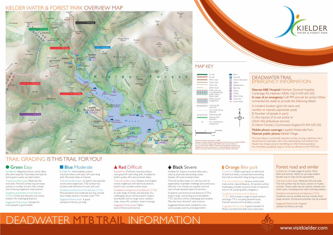
DEADWATER TRAILEMERGENCY INFORMATION
Nearest A&E Hospital: Hexham General Hospital,
Corbridge Rd, Hexham NE46 1QJ 01434 655 655.
In case of an emergency: Call 999 and ask for police. When
connected be ready to provide the following details:
A. Incident location (grid ref, name and
number or nearest waymarker post)
B. Number of people in party
C. Any injuries (if so ask police to
inform the ambulance service)
D. Inform Forestry Commission England 01434 220 242.
Mobile phone coverage: Leaplish Waterside Park.
Nearest public phone: Kielder Village.
TRAIL GRADING IS THIS TRAIL FOR YOU?
KIELDER WATER & FOREST PARK OVERVIEW MAP
Green EasySuitable for: Beginner/novice cyclists. Basic
bike skills required. Most bikes and hybrids.
Some green routes can take trailers.
Trail and surface types: Relatively flat
and wide. The trail surface may be loose,
uneven or muddy at times. May include
short flowing singletrack style sections.
Gradients and technical trail features
(TTFs): Climbs and descents are mostly
shallow. No challenging features.
Suggested fitness level: Suitable for
most people in good health.
Forest road and similarSuitable for: A wide range of cyclists. Most
bikes and hybrids. Ability to use maps helpful.
Routes may or may not be waymarked.
Trail and surface types: Relatively flat and wide.
The trail surface may be loose, uneven or muddy
at times. These roads may be used by vehicles and
other users, including horse riders and dog walkers.
Gradients and technical trail features (TTFs):
Gradients can be variable and may include short
steep sections. Occasional potholes may be present.
Suggested fitness level: A good
standard of fitness can help.
Blue ModerateSuitable for: Intermediate cyclists/
mountain bikers with basic off road riding
skills. Mountain bikes or hybrids.
Trail and surface types: As ‘green’ plus specially
constructed single track. Trail surface may
include small obstacles of roots and rock.
Gradients and technical trail features (TTFs):
Most gradients are moderate but may include
short steep sections. Includes small TTFs.
Suggested fitness level: A good
standard of fitness can help.
Red DifficultSuitable for: Proficient mountain bikers
with good off road riding skills. Suitable for
better quality off-road mountain bikes.
Trail and surface types: Steeper and tougher,
mostly singletrack with technical sections.
Expect very variable surface types.
Gradients and technical trail features (TTFs):
A wide range of climbs and descents of a
challenging nature will be present. Expect
boardwalks, berms, large rocks, medium
steps, drop-offs, cambers, water crossings.
Suggested fitness level: Higher
level of fitness and stamina.
Black SevereSuitable for: Expert mountain bike users,
used to physically demanding routes.
Quality off-road mountain bikes.
Trail and surface types: As ‘red’ but with an
expectation of greater challenge and continuous
difficulty. Can include any useable trail and
may include exposed open hill sections.
Gradients and technical trail features (TTFs):
Expect large, committing and unavoidable
TTFs. Sections will be challenging and variable.
May also have ‘downhill’ style sections.
Suggested fitness level: suitable for very
active people used to prolonged effort.
Orange Bike parkSuitable for: Riders aspiring to an elite level
of technical ability, incorporates everything
from full on downhill riding to big-air jumps.
Trail and surface types: Severe constructed
trails and/or natural features. All sections will be
challenging. Includes extreme levels of exposure
and or risk. Jumping ability obligatory.
Gradients and technical trail features
(TTFs): Will include a range of small medium
and large TTF’s, including downhill trails,
freeride sections and mandatory jumps.
Suggested fitness level: A good standard of
fitness, but technical skills more important.
Mountain biking is a potentially hazardous activity carrying a significant risk. It
should only be undertaken with a full understanding of all inherent risks.
Routes may change owing to tree felling and other forest operations.
No motorbikes, quadbikes, dogs or horses are allowed on the MTB trails.
MAP KEY
© Ashworth Maps & Interpretation Ltd 2009
All maps in this guide reproduced by permission of Ordnance Survey on behalf of HMSO.
© Crown copyright and database right 2009. All rights reserved. Ordnance
Survey Licence number 100049115. Unauthorised reproduction infringes Crown
Copyright and may lead to prosecution or civil proceedings. This map cannot be
used for any purpose without the express permission of Kielder Partnership.
BLOODY BUSH MTB TRAIL
LONESOME PINE MTB TRAIL
DEADWATER MTB TRAIL
DEADWATER MTB TRAIL OSPREY MTB TRAIL
BORDERLINE MTB TRAIL
CROSS BORDER MTB TRAIL
N
W E
A road
B road
Minor road
Other road
Main track
Other tracks
MTB cycle trail(on Lakeside Way, public road orforest road)
MTB cycle trail(singletrack)
Cross border cycle trail
Line of old railway(disused)
National border
National Parkboundary
Art / Architecture programme
Viewpoint
Ferry
Car park
Visitor information
Toilets
Refreshments
Bike hire
Sailing
Fishing
Water skiing
Camp site
Youth hostel
Cc
M
CC
M(s(s(s
M
pf
M
p(((
2 kilometres
1 mile
10
0