Embed Size (px)
Citation preview

172762082 - 1 -
COM/MF6/dc3 Date of Issuance 1/20/2017 Decision 17-01-009 January 19, 2017 BEFORE THE PUBLIC UTILITIES COMMISSION OF THE STATE OF CALIFORNIA
Order Instituting Rulemaking to Develop and Adopt Fire-Threat Maps and Fire-Safety Regulations.
Rulemaking 15-05-006 (Filed May 7, 2015)
DECISION ADOPTING A WORK PLAN FOR THE DEVELOPMENT OF FIRE MAP 2

R.15-05-006 COM/MP6/dc3
TABLE OF CONTENTS
Title Page
- i -
DECISION ADOPTING A WORK PLAN FOR THE DEVELOPMENT OF FIRE MAP 2 ........................................................................ 1
1. Summary .................................................................................................................... 2
2. Regulatory Background ........................................................................................... 2
3. Summary of Comments on the Workshop Report .............................................. 9
4. The Adopted Fire Map 2 Work Plan ...................................................................... 9
4.1. Three-Step Process for Developing Fire Map 2 ........................................ 9
4.1.1. Step 1: Creation of Shape A ........................................................ 10
4.1.2. Step 2: Creation of Shape B ......................................................... 12
4.1.2.1 The Peer Development Panel and Territory Leads ............ 12
4.1.2.2 Stakeholders ............................................................................. 14
4.1.2.3 The Independent Review Team ............................................. 15
4.1.2.4 Creation of Shape B ................................................................. 21
4.1.2.4.1 Step 2(a): Initial Statewide Shape B ................................ 24
4.1.2.4.2 Step 2(b): Fire-Threat Tiers .............................................. 24
4.1.2.4.3 Step 2(c): Territory-Specific Development .................... 28
4.1.2.4.4 Stakeholder Input ............................................................... 30
4.1.2.4.5 Step 2(d): IRT Review and Approval ............................. 32
4.1.2.4.6 Step 2(e): Commission Review ........................................ 33
4.1.3. Step 3: Creation and Adoption of Shape C ............................... 35
4.1.4. Depiction of Utility Infrastructure on Shape C ......................... 37
4.2. Fire Map 2 and Tree Mortality .................................................................. 39
4.3. Fire Hazards Associated with the Laguna Beach Area and the Butte Fire ...................................................................................................... 40
4.4. Dispute Resolution ...................................................................................... 41
4.5. Schedule for Fire Map 2.............................................................................. 42
4.6. SED Assistance to CAL FIRE ..................................................................... 48

R.15-05-006 COM/MP6/dc3
TABLE OF CONTENTS
Title Page
- ii -
5. Incorporating Fire Map 2 into GO 95 .................................................................. 48
6. Correcting the Shape C Map ................................................................................. 50
7. Updating Fire Map 2 .............................................................................................. 50
8. Transition of Existing Regulations to Fire Map 2 .............................................. 51
9. Schedule and Procedures for New Fire-Safety Regulations ............................ 52
10. Authority to Revise the Schedules and Procedures .......................................... 60
11. Cost Recovery .......................................................................................................... 60
12. Comments on the Proposed Decision .................................................................. 61
13. Assignment of the Proceeding .............................................................................. 62
Findings of Fact ............................................................................................................... 62
Conclusions of Law ........................................................................................................ 65
ORDER ............................................................................................................................. 77
Appendix A: Workshop Report ............................................................................. A-1

R.15-05-006 COM/MP6/dc3
- 2 -
DECISION ADOPTING A WORK PLAN FOR
THE DEVELOPMENT OF FIRE MAP 2
1. Summary
This decision adopts a work plan for the development and adoption of a
statewide fire-threat map known as Fire Map 2. The purpose of Fire Map 2 is to
designate areas where there is an elevated hazard for utility-associated wildfires
to occur and spread rapidly, and where communities face an elevated risk from
utility-associated wildfires. Fire Map 2 will be used to delineate the boundaries
of a new High Fire-Threat District where stricter fire-safety regulations apply.
The Fire Map 2 work plan adopted by today’s decision reflects input and advice
from the California Department of Forestry and Fire Protection (CAL FIRE).
Electric utilities will have primary responsibility for the development of
Fire Map 2, and CAL FIRE will have a significant role in overseeing the
development of Fire Map 2. Three electric utilities (Pacific Gas and Electric
Company, Southern California Edison Company, and San Diego Gas & Electric
Company) will jointly provide up to $500,000 to pay for expert consultants to
assist CAL FIRE in overseeing the development of Fire Map 2. This decision
establishes a rebuttal presumption that the electric utilities’ payments to expert
consultants are reasonable and may be recovered in rates.
This decision also establishes a schedule to adopt new fire-safety
regulations for the High Fire-Threat District by December 2017.
2. Regulatory Background
In October 2007, devastating wildfires driven by strong Santa Ana winds
burned hundreds of square miles in Southern California. Several of the worst
wildfires were reportedly ignited by overhead utility power lines and aerial
communication facilities in close proximity to power lines. In response to these

R.15-05-006 COM/MP6/dc3
- 3 -
wildfires, the Commission initiated Rulemaking (R.) 08-11-005 to consider and
adopt regulations to protect the public from potential fire hazards associated
with overhead power-line facilities and nearby aerial communication facilities.
The Commission issued several decisions in R.08-11-005 that together
adopted dozens of new regulations.1 Most of the new regulations consist of new
or revised rules in General Order (GO) 95. Several of the new regulations rely on
maps that designate areas where there is an elevated hazard for power-line fires
to occur and spread rapidly (fire-threat maps). These regulations include:
GO 95, Rule 18A, which requires electric utilities and communication infrastructure providers (CIPs) to place a high priority on the correction of significant fire hazards in high fire-threat areas of Southern California.
GO 95, Rules 31.2, 80.1A, and 90.1B, which set the minimum frequency for inspections of aerial communication facilities located in close proximity to power lines in high fire-threat areas throughout California.
GO 95, Rule 35 and Appendix E, which mandate increased time-of-trim clearances between vegetation and energized conductors in high fire-threat areas of Southern California.
GO 95, Rule 35, Table 1, Case 14, which requires increased radial clearances between bare-line conductors and vegetation in high fire-threat areas of Southern California.
GO 165, Appendix A, Table 1, which requires more frequent patrol inspections of overhead power-line facilities in rural, high fire-threat areas of Southern California.
GO 166, Standard 1.E., which requires each electric utility in Southern California to develop and submit a plan to reduce the risk of fire ignitions by overhead facilities in high fire-threat areas during extreme fire-weather events. Electric utilities in
1 These decisions include Decision (D.) 09-08-029, D.12-01-032, D.14-02-015, and D.14-05-020.

R.15-05-006 COM/MP6/dc3
- 4 -
Northern California must also develop and submit a plan if they have overhead facilities in high fire-threat areas that are subject to extreme fire-weather events.
The Commission in R.08-11-005 adopted three fire-threat maps on an
interim basis for use in conjunction with the previously identified fire-safety
regulations. Each map covers a different part of California. In D.12-01-032, the
Commission concluded that it was in the public interest to (1) develop and adopt
a permanent fire-threat map that covers the entire State; and (2) incorporate into
GO 95 a new High Fire-Threat District based on the newly adopted fire-threat
map; and (3) consider and adopt new fire-safety regulations for electric utility
and CIP structures in the High Fire-Threat District. The Commission also
determined that the first step towards the development of a permanent statewide
fire-threat map would be the preparation of a work plan for completing this task.
In D.14-01-010, the Commission adopted a work plan for the funding,
development, adoption, and implementation of a statewide fire-threat map. The
adopted work plan specified a two-step process. The first step was to develop
and adopt a scientifically based fire-threat map that depicts the physical and
environmental conditions associated with an elevated potential for
utility-associated wildfires (hereafter, “Fire Map 1”). The second step was to
develop a statewide map that depicts utility fire-threat zones where the
fire-safety regulations adopted in R.08-11-005 for high fire-threat areas would
apply (hereafter, “Fire Map 2”).
The Commission adopted a two-step approach based on the
recommendation by the parties that the mapping of fire hazards must precede
the mapping of utility fire-threat zones. Thus, the work plan adopted by
D.14-01-010 was limited to the development of Fire Map 1. Once Fire Map 1 was

R.15-05-006 COM/MP6/dc3
- 5 -
adopted, the Commission would turn to the development of Fire Map 2 and
revising GO 95 to incorporate a new High Fire-Threat District and fire-safety
regulations for the new district.
The California Department of Forestry and Fire Protection (CAL FIRE)
agreed to take the lead role in the development of Fire Map 1. This required
CAL FIRE to organize and lead a team with expertise in a range of disciplines,
including wildland fuels and fire behavior; meteorology; and geographic
information systems (GIS). CAL FIRE was also authorized by D.14-01-010 to
identify, select, and oversee the internal and external experts and resources that
it deemed necessary to develop Fire Map 1. D.14-01-010 approved a funding
mechanism to pay for experts selected and overseen by CAL FIRE.
The development of Fire Map 1 did not proceed as quickly as anticipated
by D.14-01-010. Therefore, in Order Instituting Rulemaking (OIR) 15-05-006 the
Commission closed R.08-11-005 and opened this current rulemaking proceeding.
As summarized in OIR 15-05-006, the scope this current proceeding is to:
[D]evelop and adopt maps that depict areas of the State where there is an elevated risk of power-line fires igniting and spreading rapidly. The California Department of Forestry and Fire Protection will have a primary role in the development of these fire-threat maps. The adopted fire-threat maps will be used to: (1) accurately designate the high fire-threat areas where many of the fire-safety regulations adopted in Rulemaking (R.) 08-11-005 apply, and (2) assess the need for additional fire-safety regulations. New fire-safety regulations will be adopted, as appropriate. (OIR 15-05-006 at 2.)
R.15-05-006 COM/MP6/dc3
- 6 -
After lengthy and complex development, the Commission adopted
Fire Map 1 in D.16-05-036. The same decision directed the parties to immediately
commence the preparation of a work plan for the development of Fire Map 2.2
Significantly, D.16-05-036 expanded the scope of the Fire Map 2 work plan to
include “fire hazards associated with historical power-line fires besides the
October 2007 fires in Southern California. These other power-line fires include
the Butte Fire that burned 71,000 acres in Amador and Calaveras Counties in
September 2015.3”
With the end goal in mind, D.16-05-036 directed the parties to continue the
quarterly meetings ordered by OIR 15-05-006 and earlier decisions to4:
Consider the need for new fire-safety regulations based on Fire Maps 1 and 2.
If appropriate, develop a menu of potential fire-safety regulations for the design, construction, operation, and/or maintenance of overhead utility facilities in the new High Fire-Threat District.
On June 2, 2016, the assigned Administrative Law Judge (ALJ) issued a
ruling that set a prehearing conference (PHC) and authorized parties to file PHC
statements. The following parties filed PHC statements on June 17, 2016:
A coalition of communication infrastructure providers (collectively, “the CIP Coalition”) comprised of the following entities:
o AT&T California and New Cingular Wireless PCS (AT&T)
2 D.16-05-036, at 2 and Ordering Paragraph 3.
3 D.16-05-036, at 2.
4 D.16-05-036, at 27 - 28 and Ordering Paragraph 4.

R.15-05-006 COM/MP6/dc3
- 7 -
o The California Cable & Telecommunications Association (CCTA)
o Comcast Phone of California, LLC (Comcast)
o Consolidated Communications of California Company (Consolidated Communications)
o Cox Communications California, LLC (Cox)
o Crown Castle NG West, Inc., (Crown Castle)
o CTIA – The Wireless Association (CTIA)
o Frontier Communications
o The Small Local Exchange Carriers
o Sprint Telephony PCS, L.P., and affiliates (Sprint/Nextel)
o Sunesys, LLC (Sunesys)
o T-Mobile West LLC d/b/a T-Mobile
o Time Warner Cable Information Services (California), LLC (TWC)
The City of Laguna Beach (Laguna Beach)
The Mussey Grade Road Alliance (MGRA)
The Commission’s Safety and Enforcement Division (SED)
A group of investor-owned and publicly owned electric utilities consisting of the following entities:
o Bear Valley Electric Service (Bear Valley)
o Liberty Utilities (CalPeco Electric) LLC (Liberty Utilities)
o Pacific Gas and Electric Company (PG&E)
o PacifiCorp d/b/a Pacific Power (PacifiCorp)
o The California Municipal Utilities Association (CMUA)
o Los Angeles Department of Water and Power (LADWP)
o Sacramento Municipal Utility District
San Diego Gas & Electric Company (SDG&E)
Southern California Edison Company (SCE)

R.15-05-006 COM/MP6/dc3
- 8 -
A PHC was held on June 22, 2016, and the Assigned Commissioner’s Scoping
Memo and Ruling (Scoping Memo) was issued on July 15, 2016.
The Scoping Memo directed the Fire Safety Technical Panel (FSTP) to
convene workshops to prepare a detailed work plan for the development,
adoption, and implementation of Fire Map 2.5 Publicly noticed workshops were
held in August - September 2016. On October 7, 2016, SCE filed and served the
Joint Parties’ Workshop Report for Workshops Held August - September 2016
(hereafter, the “Workshop Report”) on behalf of the following parties: AT&T,
Bear Valley, CCTA, CMUA, SED – Electric Safety and Reliability Branch,
Laguna Beach, Comcast, Cox, Crown Castle, CTIA, the County of Los Angeles
Fire Department, LADWP, Liberty Utilities, MGRA, PacifiCorp, PG&E, SCE,
SDG&E, Consolidated Communications, the Small LECs, SMUD, Sprint/Nextel,
Sunesys, TWC, T-Mobile, and The Utility Reform Network (TURN).
The Workshop Report included a proposed work plan for the
development of Fire Map 2 (hereafter, the “Fire Map 2 Work Plan”). A copy of
the Workshop Report is contained in Appendix A of today’s decision.
Opening comments on the Workshop Report were filed on October 14,
2016, by AT&T, the CIP Coalition, Laguna Beach, PG&E, SDG&E, and a group of
publicly owned electric utilities consisting of CMUA, LADWP, and SMUD.
Reply comments were filed on October 21, 2016, by the same parties plus MGRA,
PacifiCorp, and SCE.
5 The membership and duties of the Fire Safety Technical Panel are identified in OIR 15-05-006
at 11 - 13 and in the Assigned Commissioner’s Amended Scoping Memo and Ruling that was issued in R.08-11-005 on May 15, 2013, at 7 - 12.

R.15-05-006 COM/MP6/dc3
- 9 -
The Scoping Memo provided an opportunity for parties to file motions for
evidentiary hearings on the Workshop Report. No such motions were filed.
3. Summary of Comments on the Workshop Report
All parties who filed comments and/or reply comments on the Workshop
Report generally support the Fire Map 2 Work Plan. At the same time, many of
the commenting parties recommended one or more revisions to the Work Plan.
4. The Adopted Fire Map 2 Work Plan
We concur with the general consensus among the parties that the
Workshop Report provides a reasonable and scientifically driven plan for
developing Fire Map 2. Therefore, we will adopt the Workshop Report’s plan for
developing Fire Map 2, but with several modifications. Most of the adopted
modifications are intended to streamline the development of Fire Map 2. The
modified Fire Map 2 Work Plan adopted by today’s decision reflects input and
advice from CAL FIRE.
We recognize that the development of a statewide Fire Map 2 will be a
challenging task that will require considerable time and resources from
CAL FIRE, electric utilities, and the parties. To keep the development of
Fire Map 2 moving forward, parties should not let their desire for perfection in
Fire Map 2 delay the development of a reasonable Fire Map 2. As a general
principle, parties should resolve uncertainties and disputes quickly by choosing
the alternative that best protects public safety.
4.1. Three-Step Process for Developing Fire Map 2
Consistent with the Workshop Report, we adopt a three-step process to
develop and adopt Fire Map 2. Step 1 is the creation of a map known as

R.15-05-006 COM/MP6/dc3
- 10 -
Shape A, Step 2 is the creation of a map known as Shape B, and Step 3 is the
creation of a final map known as Shape C. Each step is summarized below.
4.1.1. Step 1: Creation of Shape A
The first step in the development of Fire Map 2 is the creation of a
preliminary statewide fire-threat map called Shape A. Shape A will be fashioned
from the following inputs specified in the Workshop Report:
1. Cells on Fire Map 1 with a Utility Fire-Threat Index value that is equal to or greater than 800.6
2. Cells on CAL FIRE’s Fire Resource and Assessment Program (FRAP) map of fire threats (FRAP map) classified as High, Very High, or Extreme.
3. Historic fire perimeter data (all causes) in CAL FIRE’s FRAP data base.
4. The intersection of the following areas associated with communities at risk from wildfire (CARs):
i. Areas classified as “Very High” on CAL FIRE’s map of Fire Hazard Severity Zones (FHSZs), and
ii. Areas within the boundaries of communities on record with CAL FIRE as being at risk from wildfire and to a distance of 1.5 miles outside the edges of the CARs boundaries.7 In cases where there are no municipal boundaries for a particular CAR, the area for the CAR that will be used to develop Shape A is the CAR’s point
6 Cells on Fire Map 1 with a Utility Fire-Threat Index value of 800 or higher cover an area
equal to approximately 13% of California and constitute approximately 15% of the cells on Fire Map 1 with a Utility Fire-Threat Index value of 10 or higher.
7 There are approximately 1,329 communities currently on record with CAL FIRE as being at risk from wildfire, including the City of Laguna Beach. The list is available at: http://osfm.fire.ca.gov/fireplan/fireplanning_communities_at_risk.

R.15-05-006 COM/MP6/dc3
- 11 -
location on CAL FIRE’s statewide map of CARs plus a radius of 1.5 miles around the point location.8
The Workshop Report states that Shape A will be created by SDG&E and
Reax Engineering (Reax), and submitted to CAL FIRE or another neutral expert
designated by the Commission. Today’s decision designates CAL FIRE.
On December 8, 2016, SDG&E filed and served notice of the Shape A
approved by CAL FIRE. The notice included an electronic copy of the
CAL FIRE-approved Shape A in portable document format (PDF) and
instructions for obtaining a data file for Shape A that is readable by commonly
available geographic information system (GIS) software.9
The CAL FIRE-approved Shape A covers more than half of California. We
find that the CAL FIRE-approved Shape A provides a reasonable starting point
for the creation of Shape B. We address the creation of Shape B in the following
sections of today’s decision.
We decline to adopt the proposal in the Workshop Report to require
Shape A to be filed at the Commission via a Tier 1 advice letter. This procedure
allows any person (including non-parties, individuals, groups, or organizations)
to protest an advice letter within 20 days of the date the advice letter is filed.10
8 It would only be necessary to determine CAR boundaries for those CARs that are not
otherwise included in Shape A as a result of applying Factors 1 – 3. As noted in the Workshop Report, there may be some CARs that do not meet the intersecting criteria in Item 4 (i.e., none of the CAR is within an area classified as “Very High” on CAL FIRE’s map of Fire Hazard Severity Zones) and thus not included in Shape A. (Workshop Report, Attachment A, Footnote 4.)
9 The notice also included an internet link to a statewide map prepared by CAL FIRE that shows the intersection of CARs and associated FHSZs that was used to develop Shape A.
10 GO 96-B, General Rule 7.4.

R.15-05-006 COM/MP6/dc3
- 12 -
Thus, the status of Shape A would be uncertain for at least 20 days, and longer if
protests are filed. This uncertainty could delay the development of Fire Map 2.
Moreover, the advice letter would serve little purpose because Shape A is
not the final map, but only the starting point for the creation of Shape B. As
described below, parties will have an opportunity to recommend corrections of
any perceived defects in Shape A during the development of Shape B. We
believe it would be a better use of the Commission’s and the parties’ limited
resources to focus on developing Shape B rather than reviewing, approving, and
possibly litigating Shape A through the advice letter process.
4.1.2. Step 2: Creation of Shape B
Except as noted below, we adopt all provisions in the Workshop Report
regarding the creation and approval of Shape B.
Shape B will be a refinement of the CAL FIRE-approved Shape A. The
refinements will be based on utilities’ and other Stakeholders’ knowledge of local
conditions affecting utility-associated wildfire hazards and risks. Additionally,
Shape B will be subdivided geographically into fire-threat Tiers to delineate
different levels of utility-associated wildfire hazards and risks.
To ensure consistency and technical rigor, Shape B will be (1) developed
by the Peer Development Panel (PDP) described below, which will assign
territory-specific mapping roles to Territory Leads; and (2) reviewed and
approved by an Independent Review Team (IRT) led by CAL FIRE.
4.1.2.1 The Peer Development Panel and Territory Leads
The PDP will have overall responsibility for developing the statewide
Shape B and Shape C maps, which will be the main building blocks for
Fire Map 2. The core of the PDP will consist of a small number of persons with
expertise in areas directly related to development of the fire-threat maps. The

R.15-05-006 COM/MP6/dc3
- 13 -
Workshop Report anticipates that the PDP will include personnel from PG&E,
SDG&E, SCE, PacifiCorp, AT&T, SMUD, LADWP, and Reax.11 We adopt the
recommendation by Laguna Beach to allow the Fire Chief for the City of Laguna
Beach, who has been actively participating in this phase of the proceeding, to be
included on the PDP as an expert on wildfire risks to communities.12
We adopt the Workshop Report’s proposal for the PDP to be led by
SDG&E and Reax.13 We also adopt the CIP Coalition’s proposal to add PG&E as
a co-leader.14 We further adopt SDG&E’s recommendation to limit the
membership of the PDP to persons with expertise in areas directly related to the
development of fire-threat maps.15 The PDP co-leaders will file and serve the
PDP roster,16 and the Assigned Commissioner and/or the assigned ALJ may
resolve disputes regarding the PDP roster.17
The Workshop Report describes the Territory Leads as the individuals or
entities responsible for assisting the PDP by developing territory-specific maps
for Shapes B and C. The investor-owned electric utilities (IOUs) and
publicly-owned electric utilities (POUs) are the presumptive Territory Leads for
their service areas. If there is no utility with electric facilities in a given territory,
11 Workshop Report, at 6.
12 Laguna Beach Comments on the Proposed Decision, at 2.
13 Workshop Report, at 6.
14 CIP Coalition Comments at 2 – 3. PG&E is willing to serve as a co-lead of the PDP. (PG&E Reply Comments, at 2 – 3.)
15 SDG&E Comments on the Proposed Decision, at 3.
16 Workshop Report, at 6.
17 Workshop Report, at 6, Footnote 10.

R.15-05-006 COM/MP6/dc3
- 14 -
or the IOU or POU does not want to be the Lead for its service territory, the PDP
will be responsible for creating the Shape B for that territory.18
The Workshop Report allows CIPs, IOUs, and POUs with facilities
adjacent to or in a territory to have specialists (with the appropriate expertise)
participate with the Territory Lead in the development of Shapes B and C for a
given territory. Parties participating as Territory Leads or working with the
Territory Leads are not necessarily part of the statewide PDP but may be.19
We decline to adopt the Workshop Report’s proposal that Stakeholder
Parties should have no role in the creation of Shape B unless they are a member
of the PDP, a Territory Lead, or part of the Independent Review Team.20 We will
allow all Stakeholder Parties to submit informal comments to a Territory Lead
using the web-based integrated project management/version control software
used by the PDP. The Territory Lead shall consider all comments offered by
Stakeholder Parties as the Territory Lead creates Shape B for its service territory.
To facilitate collaboration with the Territory Leads, we will require the
PDP to file and serve a roster of all Territory Leads, the territory covered by each
Lead, and contact information for each Lead. The areas covered by the Territory
Leads listed on the roster shall together encompass all of California.
4.1.2.2 Stakeholders
The Workshop Report describes Stakeholders as entities that may be
subject to regulations based on Fire Map 2 (e.g., IOUs, POUs, and CIPs) and
18 Workshop Report, at 6.
19 Workshop Report, at 6 - 7.
20 Workshop Report, at 8.

R.15-05-006 COM/MP6/dc3
- 15 -
other interested groups (e.g., CAL FIRE, local municipalities and fire districts,
and TURN). Any Stakeholder may request party status in this proceeding in
accordance with Rule 1.4 of the Commission’s Rules of Practice and Procedure.
Stakeholder Parties may contribute to the development of Shape B by submitting
informal comments to the Territory Leads as described previously, and by filing
formal comments at the Commission regarding Shape B as descried below.
4.1.2.3 The Independent Review Team
The Workshop Report proposes the establishment of a group called the
Technical Review Team to independently review the PDP’s development of
Shapes B and C. Consistent with the Workshop Report, we will establish a group
called the Independent Review Team (IRT) to provide independent oversight
and review of the PDP’s development of Shapes B and C.
We adopt the Workshop Report’s recommendation to have CAL FIRE lead
the IRT.21 CAL FIRE is exceptionally well qualified to provide independent
oversight and review of the PDP’s development of Shapes B and C, which will be
based on data and maps prepared by CAL FIRE, including Fire Map 1, the
FRAP fire-threat map, CAL FIRE’s list of communities at risk (CARs) from
wildfire, and CAL FIRE’s maps of the fire hazard severity zones (FHSZs) within
or adjacent to the CARs. More broadly, CAL FIRE has unsurpassed expertise,
experience, and knowledge with respect to mapping fire threats across
California’s vast and complex landscape. We appreciate CAL FIRE’s willingness
to take on the important role of leading the IRT.
21 Workshop Report, at 7.

R.15-05-006 COM/MP6/dc3
- 16 -
To preserve the independence of CAL FIRE and the IRT, CAL FIRE will
have sole authority to (1) determine the internal and external resources needed
for the IRT, (2) determine the number and qualifications of the IRT’s members,
and (3) identify, select, and manage the IRT members. CAL FIRE will control the
IRT’s activities, and all IRT work products will reflect CAL FIRE’s independent
judgement and expertise.
Although the Workshop Report requires the IRT to file and serve the final
IRT roster, we will direct SED’s Advocacy Staff to file and serve the roster
because of SED’s extensive experience with the Commission’s regulatory
procedures. We decline to adopt the Workshop Report’s recommendation to
authorize the Assigned Commissioner and/or the assigned ALJ to resolve
disputes regarding the composition of the IRT. As stated previously, CAL FIRE
will have complete control over the IRT.
So that the development of Fire Map 2 does not become bogged down in
disputes over technical issues and other matters, we adopt SDG&E’s
recommendation to empower the IRT to provide guidance and to decide
deadlocked issues regarding the development of Fire Map 2.22 Providing the IRT
with such authority well help ensure that Fire Map 2 is technically sound and
developed expeditiously. It will also require the IRT to be available and engaged
throughout the development of Fire Map 2. The PDP shall develop Shape B and
Shape C in accordance with the IRT’s guidance and decisions.
The IRT’s authority to render guidance and decisions regarding the
development of Fire Map 2 does not constitute an improper delegation of the
22 SDG&E Comments, at 4.

R.15-05-006 COM/MP6/dc3
- 17 -
Commission’s authority as suggested by the CIP Coalition.23 The Commission
recognized in D.16-01-014 that public agencies may delegate the performance of
ministerial tasks, including (1) the investigation and determination of facts
preliminary to agency action, and (2) making preliminary recommendations and
draft orders. An agency's subsequent approval or ratification of a delegated act
validates the act, which becomes the act of the agency itself.24
Here, the role of the IRT is to oversee the PDP’s development of Shapes B
and C. Parties will have an opportunity to submit formal comments and/or
protests to the Commission regarding the Shapes B and C that are developed in
accordance with the IRT’s guidance and decisions. The Commission will review
any comments or protests, revise Shapes B and/or C as the Commission deems
appropriate, and adopt a final Fire Map 2. Consequently, there is no improper
delegation of authority to the IRT.
To ensure that the IRT has adequate expertise and resources to perform its
responsibilities within the schedule adopted by today’s decision, we adopt the
following variant of the Workshop Report’s recommendation25 to hire and fund
expert consultants to assist the IRT:
CAL FIRE will identify the specific experts and resources needed to assist the IRT.
PG&E, SCE, and SDG&E shall contract with, and pay for, expert consultants and resources identified by CAL FIRE.
23 CIP Coalition Reply Comments, at 6 – 7.
24 D.16-01-014 at 88, citing D.09-05-020 at 2 – 3.
25 Workshop Report, at 17 – 19.
R.15-05-006 COM/MP6/dc3
- 18 -
To ensure independence, the activities and work products of the expert consultants hired by the IOUs shall be determined and overseen by CAL FIRE.
CAL FIRE will review and approve the expert consultants’ invoices and deliverables. If requested by CAL FIRE, SED Advocacy Staff shall assist CAL FIRE in reviewing and processing invoices.
PG&E, SCE, and SDG&E shall choose one among themselves to prepare and execute the contract(s) appropriate to CAL FIRE’s requirements26 and the utility’s normal contracting practices.27 The contractor(s) shall record billable costs for time, materials, and expenses, which will be reviewed for accuracy and reasonableness by CAL FIRE and/or SED Advocacy Staff. After approval from CAL FIRE and/or SED, the contractor(s) shall directly bill the lead IOU, which in turn may bill the two other IOUs for their proportionate shares of the lead IOU’s payments to the contractor(s).
26 For example, the contract may provide that services will be subject to the supervision of
CAL FIRE and any limits as to time, expenses and costs will be determined by CAL FIRE, with the understanding that payment would be subject to any provisions adopted by the Commission.
27 For example, IOUs routinely include contract provisions that encourage the contractor, to the extent subcontractors are engaged, to utilize Commission-audited firms owned by women, minorities and/or disabled veterans.

R.15-05-006 COM/MP6/dc3
- 19 -
In conjunction with the previous bullet, one expert consultant may be selected as the lead vendor to prepare and execute sub-contracts with other expert consultants under terms and conditions appropriate to CAL FIRE’s requirements and the utility’s normal contracting practices.28 The lead vendor will manage and make payments to the sub-contractors. The lead vendor will record billable costs for time, materials, and expenses, which will be reviewed for accuracy and reasonableness by CAL FIRE and/or SED Advocacy Staff. After approval from CAL FIRE and/or SED, the lead vendor will directly bill the lead IOU, which in turn may bill the other two IOUs for their proportionate shares of the lead IOU’s payments to the lead vendor.
PG&E, SCE and SDG&E shall share the total payments using the following allocation: PG&E (49%), SCE (41%) and SDG&E (10%). This allocation is based on 2011 annual electric revenue as an allocation proxy.
Total IOU payments for expert consultants and other resources, as determined by CAL FIRE, through the creation of a final statewide Fire Map 2 is capped at $500,000.
PG&E, SCE, and SDG&E may record their payments (or allocated share of payments) to the contractor(s) in their Fire Hazard Prevention Memorandum Accounts (FHPMAs) that are described in D.12-01-032 at 153-156.
Because the need for expert consultants and other resources to assist the IRT will be determined by CAL FIRE, and the work will be directed and reviewed by CAL FIRE, there will be a rebuttable presumption that the payments (or allocated share of payments) recorded in the FHPMAs, not to exceed $500,000, are reasonable and may be recovered in rates.
28 Ibid.

R.15-05-006 COM/MP6/dc3
- 20 -
CAL FIRE and/or SED must seek Commission approval to exceed the cost cap, if needed. The cost responsibility for any additional expenditures above the initial cost cap of $500,000 will be considered at that time. If PG&E, SCE and SDG&E volunteer to pay for additional expenditures, any payments booked in the respective FHPMAs will be presumed reasonable up to any new/revised cost cap authorized by the Commission.
The funding mechanism adopted by today’s decision to pay for expert
consultants and other resources to assist the IRT in overseeing the development
of Fire Map 2 is substantially similar to the funding mechanism adopted by
D.14-01-010 for the development of Fire Map 1.
We recognize that it may be necessary to enter into sole-source contracts
for expert consultants and resources to assist the IRT because of (1) the need to
hire expert consultants quickly for IRT-related work that will begin immediately
after the issuance of today’s decision; and (2) the potentially small number of
consultants who have the requisite expertise, knowledge, and experience; can
begin work immediately; and can devote considerable time to the IRT for a
period of 11 to 12 months.29
We also recognize that CAL FIRE, in anticipation of today’s decision, has
been working with expert consultants since December 2016 to expedite the
development of Fire Map 2. This work has included the formation of the IRT,
planning the IRT’s specific duties and responsibilities, consulting with the PDP
regarding the development of the project management software described below,
29 The adopted schedule for the development of Fire Map 2 is contained in Section 4.5 of
today’s decision.

R.15-05-006 COM/MP6/dc3
- 21 -
and performing other work with the assistance of expert consultants. Therefore,
we will authorize the funding mechanism adopted by today’s decision to
encompass work performed by expert consultants under CAL FIRE’s direction
beginning in December 2016.
Although the Workshop Report recommends a cost cap of $250,000 for
outside experts and resources, we will adopt a higher cost cap of $500,000 based
on our experience with the development of Fire Map 1, which required nearly
$500,000 of funding from the IOUs for outside experts and resources. We believe
it is prudent to establish a higher cost cap in order to avoid any interruption in
the IRT’s work – and the consequent delay in the development of Fire Map 2 –
that could occur if the recommended cost cap of $250,000 were to be exceeded.
We agree with the Workshop Report’s recommendation that the payments
made to contractor(s) by PG&E, SCE, and SDG&E pursuant to today’s decision
shall have no precedential value as to the percentage of cost responsibility or
non-responsibility of other parties for any other aspects of this proceeding.30
4.1.2.4 Creation of Shape B
The PDP will have overall responsibility for creating Shape B, with heavy
reliance on the Territory Leads and oversight by the IRT.31
To help manage the process of creating Shape B, we adopt the Workshop
Report’s suggestion to require the PDP to use web-based integrated project
management/version control (IPM/VC) software.32 This software will allow the
30 Workshop Report, at 18.
31 Workshop Report, at 5, 6, and 8.
32 The contemplated IPM/VC software is akin to a web-based enterprise data application.

R.15-05-006 COM/MP6/dc3
- 22 -
IRT, PDP, and each Territory Lead to create an account that makes it possible to
initiate “tickets” that feature proposed changes. For example, a Territory Lead
may propose a modification to Shape B by initiating a ticket, attaching a GIS
shapefile for the proposed change, and providing a written justification for the
proposed change. This ticket and its attachments will be immediately viewable
by anyone with a web browser. The PDP will use the ticket to comment on the
proposed change, ask questions, request additional information, and accept,
modify, or reject the change. As a result, the entire process for creating Shape B
will be transparent and documented.33 To ensure that the IPM/VC software
meets the needs of the IRT, we will direct the PDP to consult with the IRT prior
to selecting and implementing the software.
So that Stakeholder Parties can monitor and participate in the
development of Fire Map 2, we will require the PDP to provide Stakeholder
Parties with access to the IPM/VC software and the ability to view all tickets,
create their own tickets, and respond to other parties’ tickets. The PDP shall file
and serve instructions for Stakeholder Parties to access and use the IPM/VC
software within 30 days from the effective date of today’s decision.34
In their comments on the Proposed Decision, the Joint POUs state that a
Territory Lead or Stakeholder Party may wish to use sensitive information
regarding the nature and location of critical infrastructure (sensitive information)
33 Workshop Report, Attachment 2, Section 3.2.1. The PDP, in consultation with the IRT, may
use procedures other than “tickets,” but the selected procedures must be transparent to Stakeholder Parties and Territory Leads.
34 The 30-day period is based on the Joint IOUs’ Comments on the Proposed Decision, at 4 and 14.

R.15-05-006 COM/MP6/dc3
- 23 -
to demonstrate that a particular area should be included in Tier 2 or Tier 3. The
Joint POUs request a means for Territory Leads and Stakeholder Parties to
(1) propose a change to Tier boundaries based on sensitive information that is
not provided through the “transparent” IPM/VC software, and (2) remove
sensitive information that is inadvertently posted on the IPM/VC software.35
We strongly discourage the use of sensitive information to justify changes
to Tier boundaries. Territory Leads (TLs) and Stakeholder Parties (SPs) should
use publicly available information such as Google Earth to identify the location
of critical infrastructure. TLs and SPs should also use general, non-sensitive
descriptions of critical infrastructure such as “transmission line,” “government
facility,” or other general descriptors. However, if it becomes necessary to use
sensitive information to justify a proposed change to a Tier boundary, which we
strongly discourage, a TL or SP may submit the sensitive information directly to
CAL FIRE and the PDP co-leads PG&E and SDG&E (but not Reax) using a secure
and confidential means of communication (e.g., thumb drive). CAL FIRE and the
PG&E and SDG&E co-leads may share sensitive information with other members
of the IRT and PDP, as appropriate, who are authorized to view sensitive
information.
Sensitive information should not be posted on the IPM/VC software. If
sensitive information is inadvertently posted on the IPM/VC software, the PDP
should remove the material as soon as possible after learning of the incident.
35 Joint POUs’ Comments on the Proposed Decision, at 4 – 5.

R.15-05-006 COM/MP6/dc3
- 24 -
4.1.2.4.1 Step 2(a): Initial Statewide Shape B
Using the CAL FIRE-approved Shape A from Step 1 as the starting point,
the development of Shape B will occur in the following sequence. In Step 2(a),
the PDP will run statewide GIS operations to carve out areas from the
CAL FIRE-approved Shape A that cannot propagate wildfires such as barren
landscapes, irrigated agricultural land, and high-density urban areas. The PDP
will also refine Shape B on a statewide basis to: (i) Include and exclude polygons
from Shape B based on demonstrably incorrect logic in Fire Map 1 or the FRAP
fire-threat map, and (ii) to exclude high fire-threat cells that are isolated spatially.
We will require the PDP to consult with the IRT prior to executing these carve
outs and refinements, and the IRT to approve carve outs and refinements so as to
avoid the possibility of having to re-do this initial step and all subsequent steps.
Any impasse between the PDP and IRT in Step 2(a) shall be resolved in
favor of the IRT. Stakeholder Parties may use their preferred carve outs and
refinements to create and submit alternative Shape Bs for the Commission’s
consideration in Step 2(e).
4.1.2.4.2 Step 2(b): Fire-Threat Tiers
In Step 2(b), the PDP will develop a conceptual framework to divide
Shape B into geographic fire-threat Tiers. However, the number of Tiers was left
for parties to address in their comments on the Workshop Report and for the
Commission to decide.
We adopt SDG&E’s recommendation to divide Shape B into three
fire-threat Tiers.36 We agree with the Workshop Report’s suggestion, as modified
36 SDG&E Comments at 5, and SDG&E Reply Comments at 2 – 3.

R.15-05-006 COM/MP6/dc3
- 25 -
by SED’s comments on the Proposed Decision,37 to broadly define the three Tiers
as follows38:
Tier 1: Areas with zero to moderate wildfire risk.
Tier 2: Areas with elevated wildfire risk.
Tier 3: Areas with extreme wildfire risk.
Tiers 2 and 3 will together comprise Shape B. Tier 1 will consist of all areas
outside of Shape B.
We decline to adopt AT&T’s proposal to direct the PDP to determine if
there should be more than three fire-threat Tiers as part of the development of
Shape B. We appreciate AT&T’s desire to assess whether Fire Map 2 should have
more than three Tiers in order to (1) reflect the significant variability in
vegetation, topography, weather, and other factors affecting wildfire risks across
California; and (2) properly focus fire-safety regulations and utility resources.39
However, we agree with Laguna Beach that AT&T’s proposal could delay the
development and adoption of Fire Map 2.40 We also agree with Laguna Beach
and SDG&E that adopting a Shape B with more than three Tiers would add
complexity to mapping, fire-safety regulations, utility operations, and
enforcement without a meaningful improvement to fire safety.41
37 SED Comments on the Proposed Decision, at 2 - 3and A-1.
38 Workshop Report, at Attachment 2, Sections 4.1.1 and 4.1.2.
39 AT&T Comments, at 1 – 9.
40 Laguna Beach Comments, at 2 – 4.
41 Laguna Beach Comments, at 3 – 4; Laguna Beach Reply Comments, at 5 – 6, SDG&E Comments, at 5; and SDG&E Reply Comments, at 2 – 3.
R.15-05-006 COM/MP6/dc3
- 26 -
We disagree with AT&T’s assertion that adopting three fire-threat Tiers is
inconsistent with the interim fire-threat maps adopted in R.08-11-005 that have
four tiers.42 In D.12-01-032, the Commission adopted a de facto two-tier approach,
and the areas depicted on the interim fire-threat maps were divided between the
two tiers.43 The 3-tier approach adopted by today’s decision, while more
complex than the previous two-tier approach, provides more granularity
compared to the previous 2-tier approach and thereby allows fire-safety
regulations to be deployed more effectively and efficiently.
The parties did not reach a consensus on the detailed definition of each of
the three Tiers adopted by today’s decision or the means for mapping each Tier.
With one condition, we adopt the Workshop Report’s proposal to have the PDP
develop a more detailed definition of each Tier in consultation with the IRT, and
to have the IRT approve the definitions.44 Our one condition is that the Tier
definitions shall have no more than a negligible effect on the exterior boundaries
of Shape B. Put differently, the Tier definitions should not re-define or negate
the fire-threats that comprise the Initial Statewide Shape B from Step 2(a).45
Our one condition will enable the PDP to focus on defining Tier 3. Once
Tier 3 is defined, Tier 2 would consist of Shape B less the area defined as Tier 3.
42 AT&T Comments, at 4 – 5, and AT&T Reply Comments, at 1 - 4.
43 D.12-01-032, at 148 and Ordering Paragraph 12.ii.
44 Workshop Report, Attachment 2, Section 4.1.2.
45 Tier definitions should incorporate the suite of data used to produce the Fire Map 1 Utility Fire Threat Index, and may include other relevant data regarding the ignition, propagation, and spread of wildfires. An example of other relevant data is an area’s proximity to fire suppression resources, which affects the likelihood of a wildfire escaping initial attack.

R.15-05-006 COM/MP6/dc3
- 27 -
Tier 1 would consist of all areas outside of Shape B. Two examples of possible
definitions of Tier 3 provided in the Workshop Report are:
1. Areas where fire poses a significant threat to human life, has potential to damage/destroy multiple homes, or cause significant damage to the environment or other values at risk, or
2. Areas where fire consequences could be similar to the catastrophic Southern California firestorm of 2007.46
We agree with the Workshop Report’s recommendation that the Tiers
should be defined in a manner that can be applied statewide using either (1) the
“narrative approach” in the Workshop Report, Attachment 2, Table 1, or (2) the
“matrix approach” in Attachment 2, Section 5. Once the IRT has approved the
Tier definitions, the PDP shall update the Tier parameters for the matrix
approach in Workshop Report, Attachment 2, Section 5, Figure 1 and Table 2.47
The PDP shall carry out these updates in consultation with the IRT.
The PDP shall notify the Territory Leads and Stakeholder Parties of the
IRT-approved Tier definitions and the IRT-approved updates to the Tier
parameters for the matrix approach. Notice should be provided through the
IPM/VC software.
Any impasse between the PDP and IRT regarding Tier definitions shall be
resolved in favor of the IRT. Stakeholder Parties may use their preferred Tier
definitions to create and submit Shape Bs with alternative Tier definitions for the
Commission’s consideration in Step 2(e).
46 Workshop Report, Attachment 2, Section 4.1.2.
47 Workshop Report, at 12 and Attachment 2, Section 4.1.2.

R.15-05-006 COM/MP6/dc3
- 28 -
4.1.2.4.3 Step 2(c): Territory-Specific Development
In Step 2(c), each Territory Lead will develop a tiered Shape B for its
assigned territory. The starting point for each Territory Lead will be the
IRT-approved Initial Statewide Shape B from Step 2(a) and the IRT-approved
Tier definitions from Step 2(b). The Territory Lead may propose to include or
exclude areas for its territory-specific Shape B and Tiers using the criteria in the
Workshop Report, Attachment 2, Section 4.3 (the “narrative approach”) and/or
Section 5 (the “matrix approach”).
We will require all proposed exclusions from a territory-specific Shape B to
be well supported and protect public safety. For example, a Territory Lead may
propose to remove an area from Shape B if all three of the following conditions
are satisfied:
1. The removed area has no significant fire history.
2. The removed area has no proximity to communities at risk or other significant assets at risk.
3. At least one other factor in the “removal” column of the Workshop Report, Attachment 2, Table 1 is present.48
We will also require each Territory Lead to submit to the PDP a proposed
Shape B for the applicable geographic area within a timeframe set by the PDP, in
such form as directed by the PDP, and accompanied by such maps, GIS files,
information, and other material deemed necessary by the PDP. All substantive
48 SDG&E Comments, at 4.

R.15-05-006 COM/MP6/dc3
- 29 -
communications between a Territory Lead and the PDP shall occur through the
IPM/VC software and be visible to all Stakeholder Parties.49
Each territory-specific Shape B proposal will be reviewed by the PDP, who
may confer with the IRT, Territory Leads, and Stakeholder Parties. Each
proposal will be approved, modified, or rejected by the PDP, or returned to the
Territory Lead for further work. The PDP shall use the IPM/VC software to
provide an explanation for each proposal that is approved, modified, or rejected.
The IRT shall resolve any deadlocks between the PDP and Territory Leads.
We will not permit the PDP and Territory Leads to alter any carve outs or
refinements to Shape B that were approved or rejected by the IRT in Step 2(a)
unless there is good cause for doing so (e.g., the Territory Lead presents new
information that was not considered in Step 2(a)). The PDP shall notify the IRT
of any such alterations approved by the PDP and provide justification for each
alternation. The IRT may accept, modify, or reject such alterations.
The PDP will compile a statewide draft Shape B using the PDP-approved
Shape Bs submitted by the Territory Leads. The PDP-approved statewide
Shape B shall reflect all decisions made by the IRT regarding the development of
Shape B in Step 2(c). Any impasse between the PDP and the IRT in Step 2(c)
shall be resolved in favor of the IRT. Stakeholder Parties (including Territory
Leads and PDP members) may submit alternative Shape Bs for the Commission’s
consideration in Step 2(e).
49 As described in Section 4.1.2.4 of today’s decision, sensitive information regarding critical
infrastructure should not be transmitted or disclosed publicly.

R.15-05-006 COM/MP6/dc3
- 30 -
There will likely be at least six Territory Leads, and perhaps several more.
If a Territory Lead does not fulfill its responsibilities in Step 2(c) in a timely
manner, we will require the PDP to take over the development of the
territory-specific Shape B at issue so that Step 2(c) is not delayed.
To accelerate the IRT’s review of the draft statewide Shape B in Step 2(d),
we will require the PDP in Step 2(c) to provide the IRT with advance copies of
the PDP-approved, territory-specific Shape Bs as these become available.
4.1.2.4.4 Stakeholder Input
We decline to adopt the Workshop Report’s proposal to have the PDP
solicit input from the Stakeholders Parties regarding the draft statewide Shape B
that is approved by the PDP in Step 2(c).50 Today’s decision authorizes
Stakeholder Parties to communicate with the Territory Leads, the PDP, and the
IRT throughout the development of Shapes B and C using the IPM/VC software.
Stakeholder Parties will also have an opportunity in Step 2(e) to submit
(1) written comments regarding the IRT-approved statewide Shape B, and
(2) alternative Shape Bs. We conclude that today’s decision provides a
reasonable opportunity for Stakeholder Parties to provide input regarding the
development of Shape B without the additional step of requiring the PDP to
solicit input from Stakeholder Parties.
We agree with the consensus among the parties that the development of
Fire Map 2 should include input from Stakeholders who are not parties in this
proceeding. To achieve this objective, we adopt SDG&E’s recommendation to
require the Territory Leads, as part of the development of territory-specific
50 Workshop Report, at 12 – 13 and Attachment 2, Section 4.4.

R.15-05-006 COM/MP6/dc3
- 31 -
Shape Bs in Step 2(c), to solicit input from local, non-party Stakeholders with
expertise regarding local, utility-associated wildfire hazards and risks. Such
Stakeholders may include, for example, the local County Fire Chief’s Association
and/or local Fire Safe Councils.51 We also adopt SDG&E’s recommendation that
because of regional differences, each Territory Lead should decide for itself how
to identify and communicate with local, non-party Stakeholders.52
We decline to adopt the Workshop Report’s proposal to require the PDP to
solicit input on the draft statewide Shape B that is approved by the PDP in
Step 2(c) from all 1,329 CARs and all “points of contact” designated by each city
and county in California53 pursuant to Pub. Util. Code § 768.6.54 Although the
Workshop Report’s proposal to solicit input from thousands of communities
across California is well intentioned, it would require considerable time and
resources.55 We conclude that the previously described process for soliciting
Stakeholder input adopted by today’s decision, while less comprehensive than
the Workshop Report’s proposal, is sufficient to develop a Fire Map 2 that
reasonably incorporates relevant knowledge and expertise regarding local,
utility-associated wildfire threats.
51 SDG&E Comments, at 4 – 5. In a somewhat similar recommendation, PG&E proposes that
the Territory Leads should be permitted (but not required) to “invite participation from stakeholders (local fire marshals, fire safe councils, CARs, CIPs, etc.) with particular local knowledge or expertise.” (PG&E Comments at 3 – 4.)
52 SDG&E Comments, at 4 – 5.
53 PG&E states that the “points of contact” include 482 cities and 2,407 unincorporated communities. (PG&E Comments, at 3.)
54 Workshop Report, at 12 – 13 and Attachment 2, Section 4.4.
55 The concerns of CARs should be addressed, to a large degree, by their inclusion in Shape A.
R.15-05-006 COM/MP6/dc3
- 32 -
4.1.2.4.5 Step 2(d): IRT Review and Approval
In Step 2(d) the PDP will submit to the IRT for review and approval the
draft statewide Shape B prepared by the PDP at the conclusion of Step 2(c).56 We
will require the PDP to submit to the IRT a package that contains:
1. The following maps:
(i) The Initial Statewide Shape B approved by the IRT at the conclusion of Step 2(a).
(ii) The draft statewide Shape B prepared by the PDP at the conclusion of Step 2(c).
(iii) One or more maps that provide a detailed comparison of Shape B in Item (i) relative to Item (ii).
2. Instructions for obtaining an electronic copy of the required map(s) in PDF format. This requirement may be met by including a PDF copy in the package submitted to the IRT.
3. Instructions for accessing a publicly available data file for each map in Item 1, above, using commonly available GIS software.
4. A complete set of all proposed revisions to Shape B submitted by the Territory Leads in Step 2(c).
5. The PDP’s explanation for each revision to Shape B that is approved, modified, or rejected by the PDP in Step 2(c).
6. Any other information and material deemed relevant by the PDP and/or requested by the IRT.
The PDP shall serve (but not file) either the package submitted to the IRT
or a notice of availability of the package.
The IRT may (i) direct the PDP, Territory Leads, and/or Stakeholder
Parties to provide additional information, and (ii) direct the PDP to modify the
boundaries of Shape B and its Tiers. The IRT shall provide a written explanation
56 Workshop Report, at 13 – 14 and Attachment 2, Section 4.5.

R.15-05-006 COM/MP6/dc3
- 33 -
for each of its revisions to Shape B in Step 2(d). To ensure transparency, all of
these communications should occur through the PDP’s IPM/VC software.
The PDP shall prepare a final draft of Shape B in accordance with the IRT’s
instructions. Stakeholder Parties who disagree with the IRT-approved Shape B
may submit alternative Shape Bs for the Commission’s consideration in Step 2(e).
4.1.2.4.6 Step 2(e): Commission Review
In Step 2(e), the PDP shall file and serve a document that contains:
1. The IRT-approved Shape B Map from Step 2(d).
2. Instructions for obtaining an electronic copy of the required map in PDF format. This requirement may be met by including a PDF copy of the map in the document that is filed and served electronically.
3. Instructions for accessing a publicly available data file for the map in Item 1 using commonly available GIS software.
4. The IRT-approved Tier definitions from Step 2(b).
5. Any other information and documents deemed relevant by the PDP.
Five days later, Stakeholder Parties may file and serve a document that
contains an alternative Shape B. Any such document shall include the following:
One or more maps that depict the Stakeholder’s proposed boundaries relative to the IRT-approved Shape B exterior boundaries and interior Tier boundaries.
Instructions for obtaining an electronic copy of the required map(s) in PDF format. This requirement may be met by including a PDF copy of the map(s) in the document that is filed and served electronically.
Instructions for obtaining a data file for the required map(s) that is readable by commonly available GIS software.
A detailed explanation of why the Stakeholder Party’s proposed boundaries for Shape B should be adopted.

R.15-05-006 COM/MP6/dc3
- 34 -
Parties may file and serve written comments and reply comments that
address both the IRT-approved Shape B and any alternative Shape Bs. Parties
may also file and serve motions for evidentiary hearings.57 The schedule for
these filings is set forth in Section 4.5 of today’s decision.
Depending on the record developed in Step 2(e), the Assigned
Commissioner may take such actions as the Commissioner deems appropriate.
For example, if there is no opposition to the IRT-approved Shape B, the assigned
Commissioner may issue a ruling that (1) provides notice that the IRT-approved
Shape B shall be used to develop Shape C, and (2) directs the IRT, PDP, and
Territory Leads to proceed with the development of Shape C. On the other hand,
if there is opposition to the IRT-approved Shape B, the assigned Commissioner
may issue a proposed decision and/or take other appropriate actions.
We decline to adopt the Workshop Report’s proposal for the IRT-approved
Shape B from Step 2(d) to be filed at the Commission for review and approval via
a Tier 1 advice letter.58 The Tier 1 advice letter process would not provide an
opportunity for parties to submit alternative Shape Bs or a procedural vehicle for
the Commission to consider any alternative Shape Bs that are submitted. Also,
the Tier 1 advice letter process is not suitable for documents that foreseeably
could require more than ministerial review and approval by Commission staff,
which may be the case with the IRT-approved Shape B.
57 Any such motion must (i) identify and describe the specific factual issues that require an
evidentiary hearing; and (ii) provide a proposed schedule and dates for all hearing-related events, such as a PHC, service of prepared written testimony, the number of hearing days, briefs and reply briefs, etc.
58 Workshop Report, at 14.

R.15-05-006 COM/MP6/dc3
- 35 -
4.1.3. Step 3: Creation and Adoption of Shape C
Shape C is the final map product.59 To develop Shape C, we will direct the
PDP to deliver the Final Shape B from Step 2(e) to the Territory Leads, who will
overlay their electric utility overhead facilities on the Final Shape B.
Each Territory Lead shall submit the draft Shape C for its territory to the
PDP, who shall review the submittals for consistency in the way electric utility
facilities are depicted on Shape C. The PDP shall consult with the IRT, compile a
draft statewide Shape C Map, and submit the map to the IRT for review and
approval.60 The IRT may confer with the PDP, Territory Leads, and Stakeholder
Parties. The PDP shall make any revisions deemed necessary by the IRT.
Consistent with the Workshop Report’s recommendation, the PDP shall
submit the IRT-approved Final Shape C Map via a Tier 1 advice letter. The Tier 1
advice letter shall be submitted to the Commission’s Safety and Enforcement
Division (SED) and shall be effective upon SED’s or the Commission’s
disposition of the advice letter.61 Put differently, the Final Shape C Map (and
Fire Map 2) will be effective on the date the Tier 1 advice letter is approved by a
disposition letter or, if necessary, by a Commission resolution.62
We will require the advice letter to include (i) the IRT-approved Final
Shape C Map, (ii) instructions for obtaining an electronic copy of the Final
59 Workshop Report, at 14.
60 Workshop Report, at Attachment 3.
61 Workshop Report, at 15.
62 GO 96-B, General Rule 7.3, and the Joint IOU Comments on the Proposed Decision, at 14.

R.15-05-006 COM/MP6/dc3
- 36 -
Shape C Map in PDF format,63 and (iii) instructions for obtaining a data file of the
map that is readable in commonly available GIS software. Any person may
protest or respond to the advice letter within 20 days.64 If a protest is submitted,
the PDP may file minor revisions in consultation with the IRT. If major revisions
are required, SED will determine whether the advice letter must be resolved by a
Commission resolution.65
The Commission’s Energy Division shall provide whatever administrative
support that SED may need to process the advice letter. Such support may
include, for example, posting notice of the advice letter on the Commission’s
website, posting notice of SED’s disposition of the advice letter, and archiving
the advice letter.
We decline to adopt the Workshop Report’s recommendation to adjust
Tier boundaries during the development of Shape C to take into account the
location of utility facilities. For example, if an overhead electric utility circuit
crosses Tier boundaries, the Workshop Report proposes that there should be an
opportunity to adjust Tier boundaries in a way that divides the circuit between
the Tiers in a logical manner for the purpose of applying fire-safety regulations.
We conclude that public safety is better protected by having Fire Map 2
boundaries reflect actual fire threats instead of utility operational concerns. We
believe that such concerns are better addressed by adjusting regulations rather
than adjusting Tier boundaries. For instance, for an electric utility circuit that
63 This requirement may be met by including a PDF copy with the advice letter that is
submitted and served electronically.
64 GO 96-B, General Rule 7.4.
65 GO 96-B, General Rule 7.3.

R.15-05-006 COM/MP6/dc3
- 37 -
crosses Tier boundaries, the default rule could be that the electric utility would
have the option of applying the stricter regulation applicable to the portion of the
circuit in the higher fire-threat Tier to the nearest logical stopping point on the
portion of the circuit in the lower fire-threat Tier.
In the next phase of this proceeding, parties may propose one or more
rules for applying regulations to electric utility overhead circuits and other utility
facilities that cross Tier boundaries.
4.1.4. Depiction of Utility Infrastructure on Shape C
The Scoping Memo contemplated that Fire Map 2 should identify the types
and locations of (i) overhead power-line facilities in high fire-threat areas, and
(ii) aerial telecommunication facilities in close proximity to overhead power-line
facilities in high fire-threat areas.66
To achieve this objective with respect to electric utility facilities, we adopt
the Joint IOUs’ recommendation to require the Shape C Map to depict each
overhead electric utility circuit as either a line or a buffered area that
approximates the location of the circuit on the map, depending on the electric
utility’s available GIS data. Two or more circuits that share the same support
structures may be shown as a single line or buffered area on the map, if
appropriate.67 Electric utilities shall provide to Commission staff, upon request,
detailed information for any circuit depicted on the Shape C Map, such as
voltage, cable size, span lengths, etc.
66 Scoping Memo, at Appendix B, page B-2.
67 Joint IOUs Comments on the Proposed Decision, at 12, 14, and 21.

R.15-05-006 COM/MP6/dc3
- 38 -
We adopt the CIP Coalition’s recommendation that Fire Map 2 should not
separately depict aerial telecommunication facilities that are in close proximity to
overhead power-line facilities. We agree with the CIP Coalition that the
depiction of overhead electric utility circuits on Shape C implicitly incorporates
aerial communications facilities that are in close proximity.68
Moreover, as noted by the CIP Coalition, it would be challenging at this
time to separately include on the Shape C Map all telecommunication facilities in
close proximity to power-line facilities. There are hundreds of facilities-based
telecommunication providers on the Commission’s list of certificated or
registered providers, the vast majority of which are not participating in this
proceeding. Additionally, it is unclear whether all these providers have
GIS-ready maps of their facilities that could be applied to Fire Map 2. Also
complicating the mapping effort is the fact that in many instances there are
multiple CIPs on the same pole.69
We emphasize that although we do not require the Shape C Map to depict
aerial telecommunication facilities at this time, it will be the responsibility of
every CIP to know where it has facilities that are located in close proximity to
overhead power-line facilities depicted on the Shape C Map and to comply with
all fire-safety regulations that are applicable to these CIP facilities. We also
provide notice that in the future we may require aerial telecommunications
facilities to be depicted on the Shape C Map if doing so is necessary to develop or
enforce fire-safety regulations.
68 CIP Coalition Comments, at 4 – 5 and Attachment 1.
69 CIP Coalition Comments, Attachment 1, page A-4.
R.15-05-006 COM/MP6/dc3
- 39 -
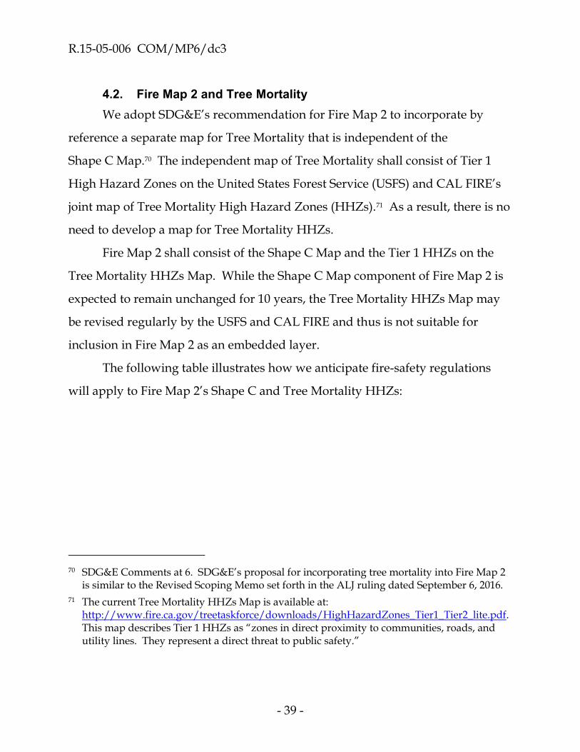
4.2. Fire Map 2 and Tree Mortality
We adopt SDG&E’s recommendation for Fire Map 2 to incorporate by
reference a separate map for Tree Mortality that is independent of the
Shape C Map.70 The independent map of Tree Mortality shall consist of Tier 1
High Hazard Zones on the United States Forest Service (USFS) and CAL FIRE’s
joint map of Tree Mortality High Hazard Zones (HHZs).71 As a result, there is no
need to develop a map for Tree Mortality HHZs.
Fire Map 2 shall consist of the Shape C Map and the Tier 1 HHZs on the
Tree Mortality HHZs Map. While the Shape C Map component of Fire Map 2 is
expected to remain unchanged for 10 years, the Tree Mortality HHZs Map may
be revised regularly by the USFS and CAL FIRE and thus is not suitable for
inclusion in Fire Map 2 as an embedded layer.
The following table illustrates how we anticipate fire-safety regulations
will apply to Fire Map 2’s Shape C and Tree Mortality HHZs:
70 SDG&E Comments at 6. SDG&E’s proposal for incorporating tree mortality into Fire Map 2
is similar to the Revised Scoping Memo set forth in the ALJ ruling dated September 6, 2016.
71 The current Tree Mortality HHZs Map is available at: http://www.fire.ca.gov/treetaskforce/downloads/HighHazardZones_Tier1_Tier2_lite.pdf. This map describes Tier 1 HHZs as “zones in direct proximity to communities, roads, and utility lines. They represent a direct threat to public safety.”

R.15-05-006 COM/MP6/dc3
- 40 -
Fire Map 2
Shape C Tree
Mortality
Regulation
Tier 1
Moderate
Tier 2
Elevated
Tier 3
Extreme
Tier 1
HHZs
Regulation X No No Yes No
Regulation Y 5 Feet 10 Feet 15 Feet 15 Feet
Regulation Z 5 Years 3 Years 2 Years 2 Years
Fire Map 2 will be effective on the date the PDP’s Tier 1 advice letter
containing the Shape C Map in Step 3 is approved by a disposition letter or, if
necessary, by a Commission resolution.
4.3. Fire Hazards Associated with the Laguna Beach Area and the Butte Fire
Decision 16-05-036 requires the Fire Map 2 Work Plan to address the fire
hazards associated with (1) overhead facilities generally and at specific locations
such as Laguna Beach, and (2) parties’ knowledge of historical power-line fires
besides the October 2007 fires in Southern California, such as the Butte Fire that
burned 71,000 acres in Amador and Calaveras Counties in September 2015.72
The modified Fire Map 2 Work Plan adopted by today’s decision defines
Shape A in a way that incorporates the fire hazards identified in D.16-05-036.73 In
addition, the procedures adopted by today’s decision for developing Shape B
will allow Territory Leads and Stakeholder Parties to propose inclusions of fire-
threat areas on Shape B relative to Shape A. Thus, if Shape A inadvertently
72 D.16-05-036 at 2, 34 – 35, and Ordering Paragraph 3.iii.
73 Shape A includes (i) Fire Hazard Severity Zones adjacent to Laguna Beach, and (ii) the area burned by the Butte Fire.

R.15-05-006 COM/MP6/dc3
- 41 -
omits a high fire-threat area, a Territory Lead or Stakeholder Party may call
attention to this omission during the development of Shape B.
4.4. Dispute Resolution
We agree with MGRA that Stakeholder Parties should be able to raise
concerns regarding the development of Fire Map 2 prior to the final review
process in order to avoid lengthy revisions cycles at the end of the process.
Accordingly, we adopt MGRA’s recommendation to allow Stakeholder Parties to
submit informal comments to the IRT, PDP, and Territory Leads throughout the
development of Fire Map 2.74 To achieve this objective, today’s decision requires
the PDP to provide Stakeholder Parties with access to the PDP’s IPM/VC
software so that parties can (1) communicate with the PDP, IRT, and Territory
Leads; and (2) monitor information and documents that are transmitted between
or among the IRT, PDP, Territory Leads, and Stakeholder Parties.
In Section 4.1.2.3 of today’s decision, we provide the IRT with authority to
resolve technical disputes raised by Stakeholder Parties, the PDP, and Territory
Leads during the development of Fire Map 2, and we direct the PDP to develop
Fire Map 2 in accordance with the IRT’s decisions. In Step 2(e),
Stakeholder Parties who have concerns about the IRT’s resolution of disputes
with respect to Shape B may file formal comments and/or alternative Shape Bs.
In Step 3, Stakeholder Parties who have concerns about the IRT’s resolution of
disputes with respect to Shape C may file protests and responses to the Tier 1
advice letter that contains the Shape C Map. We will address Stakeholder
Parties’ concerns, if any, in Step 2(e) and Step 3.
74 MGRA Reply Comments, at 2.

R.15-05-006 COM/MP6/dc3
- 42 -
We strongly encourage Stakeholder Parties to use the previously described
dispute resolution processes if they have concerns regarding the development of
Fire Map 2. Stakeholder Parties should request intervention from the Assigned
Commissioner and/or the assigned ALJ only as a last resort, and only when the
IRT is acting in a manner inconsistent with the direction or authority provided
by today’s decision, making decisions not based on sound science, or otherwise
acting arbitrarily or capriciously.
4.5. Schedule for Fire Map 2
We adopt the Joint IOUs’ proposed schedule for the development and
adoption of Fire Map 2.75 The adopted schedule is shown in the following
Table 1.
Table 1 Schedule for the Development and Adoption of Fire Map 2
Row EVENT / TASK Timeframe
1. Step 1 re: Creation of Shape A
SDG&E and Reax create the draft Shape A.
CAL FIRE reviews the draft Shape A for conformance with the Workshop Report. SDG&E and Reax revise Shape A in accordance with CAL FIRE’s instructions.
CAL FIRE approves Shape A. SDG&E files and serves notice of the final Shape A approved by CAL FIRE.
Completed on Dec. 8, 2016
75 Joint IOUs Comments on the Proposed Decision, at 14 – 18.

R.15-05-006 COM/MP6/dc3
- 43 -
Table 1 Schedule for the Development and Adoption of Fire Map 2
Row EVENT / TASK Timeframe
2.
Step 2 re: PDP Formed and Territory Leads Identified
PDP formed and Territory Leads identified.
PDP develops Shape B work/review processes and decision-making criteria.
PDP files and serves the roster of Territory Leads.
This task performed concurrently with the tasks in Rows 1 and 3.
Dec. 2016 I
Feb. 2017
3.
Step 2 re: IRT Formed
CAL FIRE identifies IRT members and expert consultants.
IOUs initiate contract negotiations with IRT expert consultants. Contracts finalized following the Commission decision in Row 4, below.
SED Advocacy Staff files and serves the IRT roster.
These tasks performed concurrently with the tasks in Rows 1 – 2, above.
Dec. 2016 I
Feb. 2017
4. Commission issues a decision adopting a work plan for the development and adoption of Fire Map 2.
Jan. 19, 2017 (“Day 0”)
5. Step 2(a) re: Initial Statewide Shape B
Using the CAL FIRE-approved Shape A from Row 1, the PDP develops an Initial Statewide Shape B by: (i) carving out areas that cannot propagate wildfires; (ii) including and excluding polygons based on demonstrably incorrect logic in Fire Map 1 or the FRAP fire-threat map; and (iii) excluding high fire-threat cells that are isolated spatially.
PDP consults regularly with the IRT. IRT approves the Initial Statewide Shape B.
These tasks performed concurrently with the tasks in Row 6, below.
Completed by
March 20, 2017
(Day 60)

R.15-05-006 COM/MP6/dc3
- 44 -
Table 1 Schedule for the Development and Adoption of Fire Map 2
Row EVENT / TASK Timeframe
6.
Step 2(b) re: Shape B, Fire-Threat Tiers
PDP develops Tier definitions in collaboration with the IRT. IRT approves the Tier definitions.
These tasks performed concurrently with the tasks in Rows 2 – 5, above.
Completed by
March 20, 2017
(Day 60)
7.
Step 2(c) re: Shape B, Territory-Specific Development
Each Territory Lead develops a tiered Shape B for its assigned territory using as a starting point the IRT-approved Initial Statewide Shape B from Row 5 and the IRT-approved Tier definitions from Row 6.
Each Territory Lead solicits input from local, non-party Stakeholders with knowledge and expertise regarding local, utility-related wildfire hazards and risks.
Each Territory Lead submits to the PDP a proposed Shape B for the applicable territory. The Territory Lead may propose to include or exclude areas from its territory-specific Shape B and Tiers using the criteria in the Workshop Report, Attachment 2.
Proposed Shape B for each territory reviewed by PDP.
PDP compiles a draft statewide Shape B using the PDP-approved Shape Bs for each territory.
To accelerate the IRT’s review of the draft statewide Shape B in in Row 8, below, the PDP provides the IRT with advance copies of the PDP-approved, territory-specific Shape Bs as these become available.
Completed by July 17, 2017
(Day 179)
8.
Step 2(d) re: Shape B, IRT Review
PDP submits to the IRT, and serves on the service list, the PDP-approved draft statewide Shape B from Row 7.
IRT reviews the PDP’s draft statewide Shape B.
PDP prepares the statewide Final Draft Shape B in accordance with the IRT’s instructions.
Completed by Aug. 21, 2017
(Day 214)

R.15-05-006 COM/MP6/dc3
- 45 -
Table 1 Schedule for the Development and Adoption of Fire Map 2
Row EVENT / TASK Timeframe
9.
Step 2(e) re: Shape B, CPUC Review
PDP files & serves the IRT-approved Shape B from Row 8. Completed by August 28, 2017 (Day 221).
Stakeholder Parties file & serve alternative Shape Bs. Completed by September 1, 2017 (Day 225).
Stakeholder Parties file & serve comments regarding the IRT-approved Shape B and alternative Shape Bs, if any. Completed by September 11, 2017 (Day 235).
Reply comments and motions for evidentiary hearings (EHs). Completed by September 21, 2017 (Day 245).
Responses to motions for EHs. Completed by
September 29, 2017 (Day 253).
Completed by Sept. 29, 2017
(Day 253)
10. Step 2(e) re: Shape B, CPUC Review
Depending on the record developed in Row 9:
The Assigned Commissioner issues a ruling that (1) provides notice of the Final Shape B that will be used to develop Shape C, and (2) directs parties to immediately start the development of Shape C, and/or
The Assigned Commissioner takes such other actions that the Commissioner deems appropriate.
Completed by Oct. 16, 2017
(Day 270)

R.15-05-006 COM/MP6/dc3
- 46 -
Table 1 Schedule for the Development and Adoption of Fire Map 2
Row EVENT / TASK Timeframe
11. Step 3 re: Shape C Development
PDP delivers the Final Shape B from Step 2(e), Row 10 to the Territory Leads, who overlay electric utility overhead circuits onto Shape B.
Territory Leads submit their Shape Cs to the PDP.
PDP reviews the territory-specific Shape Cs for quality control and compiles the statewide Shape C.
PDP delivers the final Shape C, with justification for any changes, to the IRT for review and approval.
Completed by Nov. 10, 2017
(Day 295)
12.
Step 3 re: Shape C and Fire Map 2 Review, Approval, and Effective Date
IRT reviews the Shape C submitted by the PDP in Row 11. PDP revises Shape C in accordance with the IRT’s instructions.
The PDP submits the IRT-approved Shape C Map to SED via a Tier 1 advice letter (A/L).
Completed by Nov. 30, 2017
(Day 315)
13.
Fire Map 2 consisting of the Shape C Map and the Tree Mortality HHZs Map is effective on the date the Tier 1 A/L is approved by disposition letter or, if necessary, by a Commission resolution.
December 2017
(Estimated)
14.
New Fire-Safety Regulations
Proposed decision mailed by Oct. 27, 2017.
Fire-safety regulations for the High Fire-Threat District considered and adopted, as appropriate.
November 30, 2017

R.15-05-006 COM/MP6/dc3
- 47 -
Table 1 Schedule for the Development and Adoption of Fire Map 2
Row EVENT / TASK Timeframe
15.
Fire Map 2 Dissemination
The Director of SED incorporates the Shape C Map into GO 95 and disseminates the map in accordance with the instructions in Section 5 of today’s decision.
Interim fire-threat maps replaced by Fire Map 2.
Completed within 60 days of SED’s or the Commission’s disposition of the Tier 1 A/L
in Row 13.
Under the adopted schedule, Fire Map 2 will be submitted to the
Commission for approval by November 30, 2017, and go into effect soon
thereafter. The adopted schedule assumes there are no disputes that require a
Commission decision or an evidentiary hearing.
The schedule adopted by today’s decision for the development of
Fire Map 2 is based on the schedule recommended by Joint IOUs in their
comments on the Proposed Decision, provides significantly more time for the
development of Fire Map 2 compared to the Proposed Decision, and has the
support of all but one of the parties76 that submitted comments on the Proposed
Decision. Today’s decision also allows the electric IOUs to track and request
recovery of the costs they incur to develop Fire Map 2. In light of extra time and
resources provided by today’s decision for the development of Fire Map 2,
parties should not expect any additional extensions of the schedule for the
development of Fire Map 2.
76 The City of Laguna Beach is the only party that supports the more aggressive schedule in the
Proposed Decision. (City of Laguna Beach Reply Comments on the Proposed Decision, at 1 - 3.)

R.15-05-006 COM/MP6/dc3
- 48 -
In Section 9 of today’s decision, we adopt a separate schedule to consider
and possibly adopt fire-safety regulations for the new High Fire-Threat District
by November 2017.
4.6. SED Assistance to CAL FIRE
CAL FIRE is participating in this proceeding in an advisory capacity to aid
the Commission’s development and adoption of Fire Map 2. The Commission’s
SED Advocacy Staff, who are participating in this proceeding as a party, shall
provide whatever administrative and regulatory support that CAL FIRE may
need to participate in this proceeding. Such assistance may include, but is not
limited to, filing and serving documents on CAL FIRE’s behalf. SED Advocacy
Staff shall stay in regular contact with CAL FIRE for the purpose of monitoring
CAL FIRE’s need for support, if any.
5. Incorporating Fire Map 2 into GO 95
Fire Map 2 will consist of two independent maps – the Shape C Map and
the Tree Mortality HHZs Map. The Shape C Map will be available in two forms:
1. High resolution PDF file (no special software required for viewing). This file should be less than 50 megabytes in size.
2. Zip archive of native GIS files (when unzipped, requires GIS software and/or Google Earth for viewing). This file should be less than 50 megabytes in size.77
The Tree Mortality HHZs Map is available on CAL FIRE’s website.78
77 Workshop Report at Section III.D.1.
78 The Tree Mortality HHZs Map that is current as of today’s decision is available at: http://www.fire.ca.gov/treetaskforce/downloads/HighHazardZones_Tier1_Tier2_lite.pdf.

R.15-05-006 COM/MP6/dc3
- 49 -
The Scoping Memo directed the Fire Map 2 Work Plan to address the
procedure for incorporating Fire Map 2 into GO 95 and other GOs, if applicable.
The Workshop Report suggests this can be accomplished by way of reference to a
webpage that can be accessed from the Commission’s website.79
In accordance with the Workshop Report’s suggestion, we will instruct the
Director of SED or the Director’s designee to:
1. Arrange for the PDF and GIS files for the Final Shape C Map from Step 3 to be hosted on a Commission server and/or other server deemed appropriate by the Director.
2. Post on the Commission’s website (A) static download links to the PDF and GIS files for the Final Shape C Map, and (B) a download link to the then-current version of the Tree Mortality HHZs Map.
3. Update GOs 95, 165, 166, and other GOs, if applicable, to replace references to the interim fire-threat maps with references to Fire Map 2. The current interim fire-threat maps will be retired at that time.
The Director shall complete these tasks no later than 60 days after the date
of SED’s or the Commission’s disposition of the PDP’s Tier 1 advice letter
submittal that contains the Final Shape C Map. For the purpose of today’s
decision, the date of the SED’s disposition shall be the reported “date closed” on
the Commission’s website.
79 Workshop Report, at 19.

R.15-05-006 COM/MP6/dc3
- 50 -
6. Correcting the Shape C Map
As electric utilities, CIPs, and other Stakeholder Parties begin to use the
Shape C Map and become familiar with it, they may find material errors that
warrant correction. Today’s decision invites Stakeholder Parties and CAL FIRE
to notify SED of any material errors they discover in the Shape C Map so that the
errors can be corrected.
If SED learns of a material error in the Shape C Map, SED shall take the
following actions, as appropriate: (1) Confer with CAL FIRE; (2) correct the error
by preparing a resolution for the Commission’s consideration that explains the
error, describes the correction, and provides a corrected Shape C Map in PDF
and GIS formats; and (3) replace the download links on the Commission’s
website to the erroneous Shape C Map with links to the corrected Shape C Map.
7. Updating Fire Map 2
The Tree Mortality HHZs Map that is incorporated into Fire Map 2 by
reference may be revised from time-to-time by the USFS and CAL FIRE. We will
direct SED to periodically check CAL FIRE’s website for revisions to the map. If
and when there are revisions, SED shall update the link to the Tree Mortality
HHZs Map that SED placed on the Commission’s website in accordance with
Section 5 of today’s decision.
Consistent with the recommendation in the Workshop Report,80 we intend
to update Fire Map 2 in ten-year cycles. The Commission will have discretion in
the future to determine the exact timing of the next update cycle, the scope of the
update, and the associated processes and procedures.
80 Workshop Report, at Section IV.B.

R.15-05-006 COM/MP6/dc3
- 51 -
8. Transition of Existing Regulations to Fire Map 2
The Commission adopted a number of fire-safety regulations in
R.08-11-005 that apply only to certain high fire-threat areas on the interim
fire-threat maps adopted in that proceeding. These fire-safety regulations are
summarized in Section 2 of today’s decision.
The Scoping Memo directed the Fire Map 2 Work Plan to address the
transition of existing fire-safety regulations that rely on interim fire-threat maps
to Fire Map 2. The Workshop Report did not address this topic. Instead, the
Workshop Report states that this topic should be deferred until fire-threat Tiers
are adopted during the development of Fire Map 2 so that the adopted Tiers can
be correlated with the high fire-threat areas on the interim fire-threat maps.
We decline to adopt the Workshop Report’s proposal to defer this topic.
We conclude that the existing fire-safety regulations which apply only to high
fire-threat areas in Northern California on the interim fire-threat maps shall
apply only to areas in Northern California designated as Tier 3 (extreme fire
threat) on Shape C of Fire Map 2. Similarly, the existing fire-safety regulations
which apply only to high fire-threat areas in Southern California on the interim
fire-threat maps shall apply only to areas in Southern California designated as
Tier 3 (extreme fire threat) on Shape C of Fire Map 2.81
We adopt the Joint IOUs’ recommendation that the transfer of existing
regulations to Tier 3 should take effect as soon as possible after the Commission’s
81 Consistent with D.12-01-032, today’s decision defines Southern California as consisting of
Imperial, Santa Barbara, Ventura, Los Angeles, Orange, San Diego, Riverside, and San Bernardino Counties. Northern California is defined as all other counties in California. (D.12-01-032 at Ordering Paragraph 16.)

R.15-05-006 COM/MP6/dc3
- 52 -
adoption of Shape C as set forth in Section 4.1.3 of today’s decision.82 Consistent
with the Joint IOUs’ recommendation, we will require the transfer of existing
fire-safety regulations to be completed no later than September 1, 2018, in time
for the autumn fire season in Southern California.
We disagree with the CIP Coalition’s position that there must be a
cost-benefit analysis to determine where on Fire Map 2 it is cost effective to apply
existing fire-safety regulations, which can only occur after Fire Map 2 is
complete.83 We conclude that public safety requires the most restrictive
fire-safety regulations which currently apply only to certain high fire-threat areas
on the interim fire-threat maps should transfer automatically to Tier 3 areas on
Shape C of Fire Map 2. Pursuant to today’s decision, Tier 3 of Shape C will be
areas with extreme wildfire risk that require the most restrictive fire-safety
regulations.
In the next phase of this proceeding, parties may request refinements to
the areas on Fire Map 2 where the transferred fire-safety regulations should
apply.
9. Schedule and Procedures for New Fire-Safety Regulations
In D.14-01-010, the Commission directed the Fire Safety Technical Panel
(FSTP) to convene quarterly meetings for the purpose of developing a menu of
potential fire-safety regulations for the design, construction, operation, and/or
maintenance of overhead electric utility facilities and aerial communication
82 Joint IOUs Comments on the Proposed Decision, at 9, 18, and 22. See also SDG&E
Comments on the Proposed Decision, at 3.
83 CIP Coalition Comments, at 5.

R.15-05-006 COM/MP6/dc3
- 53 -
facilities in the contemplated High Fire-Threat District.84 The objective was to
identify and develop new fire-safety regulations concurrently with, and
informed by, the development of Fire Maps 1 and 2. These directions were
repeated in OIR 15-05-006, D.16-05-036, and the Scoping Memo for this
proceeding.85
To accelerate the possible adoption of new fire-safety regulations, the
Scoping Memo informed the parties that the FSTP should plan to submit a list of
proposed fire-safety regulations shortly after the Commission’s adoption of the
Fire Map 2 Work Plan, if not sooner. The Scoping Memo further stated that a
ruling, decision, or other guidance would be issued that sets (1) the date for
submitting the proposed regulations, and (2) the procedures for considering and
adopting the proposed regulations.
As contemplated by the Scoping Memo, today’s decision adopts the
following schedule86 and procedures to (1) integrate Fire Map 2 into GO 95 as a
new High Fire-Threat District; and (2) identify, evaluate, and possibly adopt new
fire-safety regulations for the High Fire-Threat District:
84 D.14-01-010 at 27 – 28 and Ordering Paragraph 2.
85 OIR 15-05-006 at 13 – 14; D.16-05-036 at 27 – 28 and Ordering Paragraph 3; and Assigned Commissioner’s Scoping Memo and Ruling dated July 15, 2016, at 3 – 4.
86 Today’s decision adopts, with minor modifications, the schedule in the Joint IOUs Comments on the Proposed Decision, at 19 – 20.
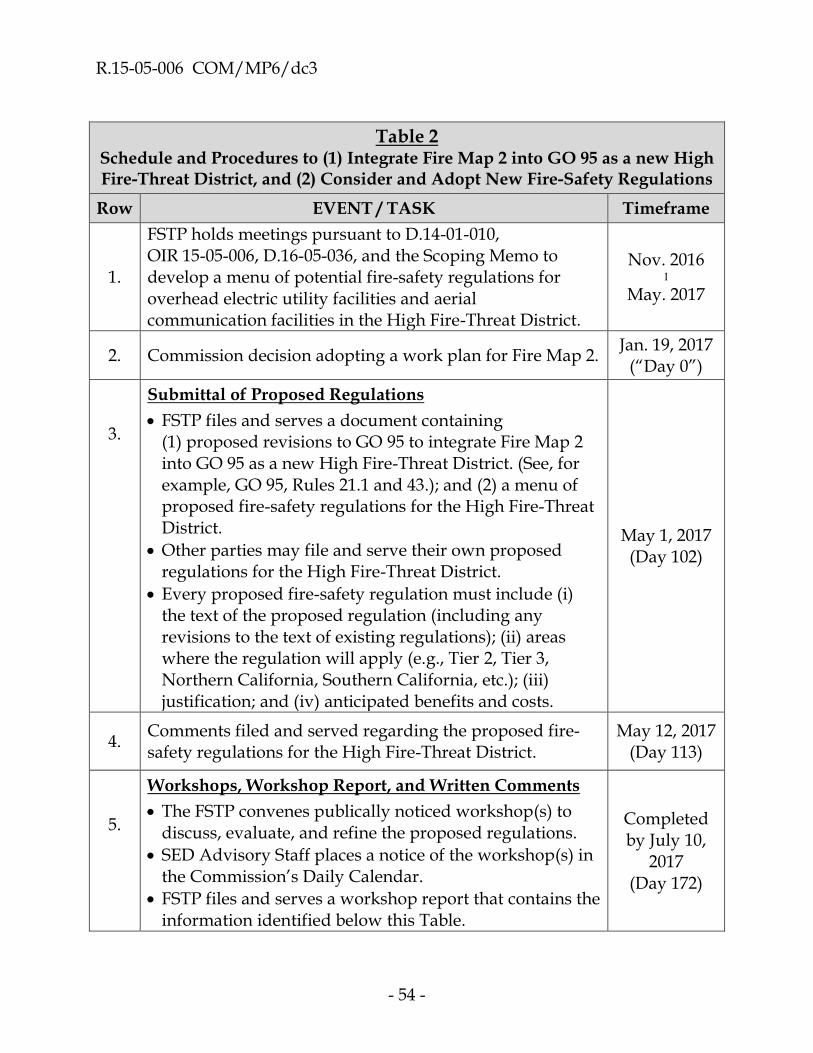
R.15-05-006 COM/MP6/dc3
- 54 -
Table 2 Schedule and Procedures to (1) Integrate Fire Map 2 into GO 95 as a new High Fire-Threat District, and (2) Consider and Adopt New Fire-Safety Regulations
Row EVENT / TASK Timeframe
1.
FSTP holds meetings pursuant to D.14-01-010, OIR 15-05-006, D.16-05-036, and the Scoping Memo to develop a menu of potential fire-safety regulations for overhead electric utility facilities and aerial communication facilities in the High Fire-Threat District.
Nov. 2016 I
May. 2017
2. Commission decision adopting a work plan for Fire Map 2. Jan. 19, 2017
(“Day 0”)
3.
Submittal of Proposed Regulations
FSTP files and serves a document containing (1) proposed revisions to GO 95 to integrate Fire Map 2 into GO 95 as a new High Fire-Threat District. (See, for example, GO 95, Rules 21.1 and 43.); and (2) a menu of proposed fire-safety regulations for the High Fire-Threat District.
Other parties may file and serve their own proposed regulations for the High Fire-Threat District.
Every proposed fire-safety regulation must include (i) the text of the proposed regulation (including any revisions to the text of existing regulations); (ii) areas where the regulation will apply (e.g., Tier 2, Tier 3, Northern California, Southern California, etc.); (iii) justification; and (iv) anticipated benefits and costs.
May 1, 2017 (Day 102)
4. Comments filed and served regarding the proposed fire-safety regulations for the High Fire-Threat District.
May 12, 2017 (Day 113)
5.
Workshops, Workshop Report, and Written Comments
The FSTP convenes publically noticed workshop(s) to discuss, evaluate, and refine the proposed regulations.
SED Advisory Staff places a notice of the workshop(s) in the Commission’s Daily Calendar.
FSTP files and serves a workshop report that contains the information identified below this Table.
Completed by July 10,
2017 (Day 172)

R.15-05-006 COM/MP6/dc3
- 55 -
Table 2 Schedule and Procedures to (1) Integrate Fire Map 2 into GO 95 as a new High Fire-Threat District, and (2) Consider and Adopt New Fire-Safety Regulations
Row EVENT / TASK Timeframe
6.
Parties file and serve comments regarding the workshop report. The comments should follow a common outline that is agreed to at the workshops.
The workshop report and comments should together provide a comprehensive summary of each party’s position. These documents may be used as a primary record for drafting a proposed decision (PD). Parties should assume that if a particular fact, argument, position, etc., is not in (or is not cited in) the workshop report or comments, it may not be considered in the PD.
July 24, 2017 (Day 186)
7. Parties file and serve reply comments on the workshop report.
Aug. 4, 2017 (Day 197)
8.
Motions for Evidentiary Hearings
Motions for evidentiary hearings filed and served.
Any such motion must (i) identify the specific proposed regulation(s) for which the movant seeks an evidentiary hearing; (ii) identify and describe the specific factual issues that require an evidentiary hearing; and (iii) provide a proposed schedule and dates for all hearing-related events, such as a PHC, service of prepared written testimony, the number of hearing days, briefs and reply briefs, etc.
Aug. 9, 2017 (Day 202)
9. Responses to motions for evidentiary hearings filed and served.
Aug. 16, 2017
(Day 209)
10. Proposed Decision (PD) mailed re: Fire-safety regulations for the High Fire-Threat District. PD placed on the agenda for the Commission meeting on Nov. 30, 2017
Oct. 27, 2017 (Day 281)
The adopted schedule for considering and possibly adopting new
fire-safety regulations for the High Fire-Threat District assumes there are no

R.15-05-006 COM/MP6/dc3
- 56 -
evidentiary hearings. It is our intention that any adopted fire-safety regulations
should go into effect as soon as possible. The specific timeframe(s) and/or
deadline(s) for implementing any new fire-safety regulations will be addressed,
as appropriate, in our decision adopting the fire-safety regulations.
The workshop report that is filed and served by the FSTP in accordance
with Row 5 of Table 2 shall include the following information:
The final iteration of all proposed fire-safety regulations (PRs) for the High Fire-Threat District.
o Pursuant to today’s decision, the PRs shall include proposed revisions to GO 95 to integrate Fire Map 2 into GO 95 as a new High Fire-Threat District. (See, for example, GO 95, Rules 21.1 and 43.)
o Pursuant to today’s decision, the PRs may include:
Proposed rules for applying fire-safety regulations to electric utility overhead circuits and other utility facilities that cross Tier boundaries.
Refinements to the areas on Fire Map 2 that will be subject to the fire-safety regulations adopted in R.08-11-005 that apply to high fire-threat areas on the interim fire-threat maps adopted in R.08-11-005.
o Pursuant to D.16-05-036, the PRs may include proposals to revise the “multiply by” provision in GO 95’s Rule 48, subject to the requirement in Ordering Paragraph 5 of D.14-02-015 that such proposals must be consistent with the primary purpose of this proceeding of enhancing the fire safety of overhead utility facilities.87
For each PR, a list of the parties who support the regulation and the parties who oppose the regulation. Parties may
87 D.16-05-036 at 27 – 28 and Ordering Paragraph 5.

R.15-05-006 COM/MP6/dc3
- 57 -
explain their support/opposition in their post-workshop comments.
Each PR shall be accompanied by a detailed description and justification that includes the following:
o The specific electric utilities, CIPs, and others affected by the PR.
o The current text of the affected General Order(s), if any.
o New and/or revised text for the affected General Order(s), if applicable, showing (i) proposed revisions in strikeout/underline form, and (ii) the final proposed rule.
o The geographic areas covered by the PR (e.g., Tier 2 areas, Tier 3 areas, Tiers 2 and 3, Northern California, Southern California, both Northern and Southern California, etc.).
o How the PR reduces or otherwise addresses fire hazards and/or risks in the High Fire-Threat District.
o The estimated costs of the PR, including, if available, costs incurred by IOUs, POUs, CIPs, and customers.
o Whether and how the costs will be recovered from customers.
o Whether and how costs will be shared among electric utilities, CIPs, and others.
o The timeframe for implementing the PR.
o Why it is in the public interest to adopt the PR.
o If the PR applies to electric transmission, why the regulation does not conflict with other federal or state regulations.
o Whether the PR is exempt from the California Environmental Quality Act (CEQA) and/or the National Environmental Policy Act (NEPA) and, if so, why. Any assertion that CEQA and NEPA do not apply must cite the relevant statues and/or regulations where the exemption is listed. Conversely, any assertion that CEQA and/or NEPA do apply must (1) cite the relevant statues and/or regulations that show this, and

R.15-05-006 COM/MP6/dc3
- 58 -
(2) list the steps that need to occur under CEQA and/or NEPA before the PR can be adopted.
A detailed summary of any ancillary issues with a direct nexus to the PRs.
Criteria regarding: (i) Where the PRs should apply with respect to new installations and reconstruction in the High Fire-Threat District; and (ii) whether existing facilities in the High Fire-Threat District should be retrofitted or replaced to conform to the PRs. These criteria should include methods for: (a) Estimating the costs and safety benefits of the PRs, and (b) weighing the costs and safety benefits.
Any other matters the workshop participants deem appropriate. Such matters may include, for example, proposed criteria for applying fire-safety regulations differently to areas having different fire risks within the same Tier.88
We respectfully disagree with the CIP Coalition’s and PG&E’s position
that it is not feasible to consider and adopt new fire-safety regulations until after
Fire Map 2 is adopted.89 Today’s decision provides detailed guidance regarding
the fire threats that will be used to develop Fire Map 2 and its fire-threat Tiers 2
and 3. In our opinion, parties have sufficient knowledge of Fire Map 2 to assess
the need for new fire-safety regulations90 and to evaluate whether any proposed
regulations would be cost effective.
We decline to adopt Laguna Beach’s and SED’s recommendations to scale
back the scope of the information that today’s decision requires parties to
88 CIP Coalition Comments at 4.
89 CIP Coalition Comments at 5, and PG&E Reply Comments at 6.
90 SDG&E reports that it is ready to propose at least one new fire-safety regulation. (SDG&E Reply Comments at 2.

R.15-05-006 COM/MP6/dc3
- 59 -
provide for each proposed fire-safety regulation.91 At the same time, we will not
reject out-of-hand a proposed regulation that is not accompanied by all of the
required information. When this occurs, the proponent of the proposed
regulation should explain why the required information has not been provided
(e.g., the required information is not available or could not be assembled with the
resources available to the proponent). We remind all parties that the proponent
of a proposed regulation has the burden of demonstrating that the regulation is
reasonable and should be adopted by the Commission. Any party that does not
provide all of the required information for a proposed regulation may have a
higher risk of its proposed regulation being rejected by the Commission.
We decline to adopt SED’s recommendation to expand the scope of this
proceeding to consider and possibly adopt proposed fire-safety regulations that
would apply to Tier 1.92 We agree with the CIP Coalition and the Joint POUs93
that it has been clear since the inception of this proceeding that the consideration
and possible adoption of new fire-safety regulations would be limited to the
High Fire-Threat District (i.e., Tiers 2 and 3).94 Moreover, this proceeding is
already overburdened as demonstrated by the numerous pleas in the parties’
comments on the Proposed Decision to extend the proceeding schedule. There is
simply no room to expand the scope of this proceeding further.
91 Laguna Beach Comments on the Proposed Decision, at 3; and SED Comments on the
Proposed Decision, at 4 - 5.
92 SED Comments on the Proposed Decision, at 3 – 4.
93 CIP Coalition Reply Comments on the Proposed Decision, at 2 - 3, and Joint POUs Reply Comments on the Proposed Decision, at 2 - 3.
94 See, for example, OIR 15-05-006, at 6-7.

R.15-05-006 COM/MP6/dc3
- 60 -
This proceeding is not SED’s only vehicle to propose new fire-safety
regulations. SED has the option of filing a petition for rulemaking pursuant to
Pub. Util. Code § 1708.5, which allows “interested persons to petition the
commission to adopt, amend, or repeal a regulation.”
10. Authority to Revise the Schedules and Procedures
The assigned Commissioner and/or the assigned ALJ may revise the
schedules and procedures adopted by today’s decision for (1) the development
and adoption of Fire Map 2; and (2) the identification, evaluation, and potential
adoption of fire-safety regulations for the High-Threat District.
11. Cost Recovery
In response to the Joint IOUs’ comments on the Proposed Decision, we
authorize cost-of-service electric utilities to recover the costs they incur pursuant
to today’s decision after the reasonableness of such costs has been verified by the
Commission.95 Depending on the utility, such costs may include expenditures
for the development, adoption, and implementation of Fire Map 2; payments to
expert consultants that are part of the IRT as described in Section 4.1.2.3 of
today’s decision; and for the transition of existing fire-safety regulations to
Fire Map 2 as described in Section 8 of today’s decision.
We adopt the Joint IOUs’ recommendation to authorize electric IOUs96 to
record the costs incurred pursuant to today’s decision in their Fire Hazard
Prevention Memorandum Accounts (FHPMAs) established pursuant to
95 Joint IOUs Comments on the Proposed Decision, at 9 - 10, 21, and 23.
96 For the purpose of today’s decision, the term “electric IOU” includes Southern California Gas Company to the extent it operates overhead power-line facilities that are subject to the Commission’s jurisdiction.

R.15-05-006 COM/MP6/dc3
- 61 -
Commission decisions issued in R.08-11-005.97 Each electric IOU may file one or
more applications to recover the costs recorded in its FHPMA. The number and
timing of such applications will be at the discretion of each IOU.98 We will verify
and assess the reasonableness of recorded costs in application proceedings.99
The electric IOUs may record in their FHPMAs only those costs which are
not already being recovered in rates. Each electric IOU may continue to record
authorized costs in its FHPMA until the first general rate case (GRC) that occurs
after the close of this proceeding (R.15-05-006), at which time the FHPMA shall
be closed. The electric IOU may then use the GRC mechanism to request
recovery of any additional costs it incurs from that point forward pursuant to
today’s decision. The electric IOU may seek to recover the ending balance in its
FHPMA, if any, by filing an application.
12. Comments on the Proposed Decision
The proposed decision was mailed to the parties in accordance with
Pub. Util. Code § 311, and comments were allowed in accordance with Rule 14.3
of the Commission’s Rules of Practice and Procedure. Comments were filed on
January 5, 2017, by the City of Laguna Beach, SDG&E, and SED; jointly by a
group of electric IOUs consisting of Bear Valley, Liberty Utilities, PacifiCorp,
PG&E, and SCE (the Joint IOUs); and jointly by group of POUs consisting of
CMUA, LADWP, and SMUD (the Joint POUs). Reply comments were filed on
January 10, 2017, by the CIP Coalition, the Joint IOUs, the Joint POUs, the City of
97 See, for example, D.09-08-029 at 43 – 44, and D.12-01-032 at 152 and Conclusion of Law 21.
98 In lieu of filing applications, an electric IOU may seek to recover the costs recorded in its FHPMA in its next scheduled general rate case application.
99 Joint IOUs Comments on the Proposed Decision, at 9 - 10, 21, and 23.

R.15-05-006 COM/MP6/dc3
- 62 -
Laguna Beach, MGRA, SDG&E, and SED. These comments and reply comments
have been incorporated, as appropriate, in the final decision adopted by the
Commission.
13. Assignment of the Proceeding
Michael Picker is the assigned Commissioner for this proceeding and
Timothy Kenney is the assigned Administrative Law Judge.
Findings of Fact
1. The purpose of Fire Map 2 is to delineate the boundaries of a new High
Fire-Threat District that encompasses (a) areas where there is an elevated hazard
for utility-associated wildfires occurring and spreading rapidly, and
(b) communities that face elevated risks from utility-associated wildfires.
2. The Fire Map 2 Work Plan in the Workshop Report, with the modifications
adopted by today’s decision, is a reasonable approach for developing and
adopting Fire Map 2.
3. The Fire Map 2 Work Plan adopted by today’s decision reflects input and
advice from CAL FIRE.
4. On December 8, 2016, SDG&E filed and served notice of the Shape A Map
approved by CAL FIRE.
5. The CAL FIRE-approved Shape A Map is a reasonable starting point for
the development of the Shape B Map.
6. The Workshop Report’s proposal to file the CAL FIRE-approved Shape A
Map at the Commission via a Tier 1 advice letter could delay the development of
Fire Map 2 and would serve little purpose because the Shape A Map is not a final
product, but the starting point for the development of the Shape B Map.
7. The CIP Coalition’s proposal that PG&E serve as a co-lead of the PDP is
reasonable. PG&E is willing to serve as a co-lead of the PDP.

R.15-05-006 COM/MP6/dc3
- 63 -
8. CAL FIRE is well qualified to lead the IRT, which will provide
independent oversight and review of the PDP’s development of Shapes B and C.
9. Adopting SDG&E’s recommendation to provide the IRT with authority to
decide deadlocked issues during the development of Fire Map 2 will help ensure
that Fire Map 2 is technically sound and developed expeditiously.
10. It may be necessary to enter into sole-source contracts for expert
consultants to assist the IRT because of (a) the need to hire expert consultants
quickly for IRT-related work that will begin immediately after the issuance of
today’s decision; and (b) the potentially small number of consultants who have
the requisite expertise, knowledge, and experience; can begin work immediately;
and can devote considerable time to the IRT for a period of 11 to 12 months.
11. CAL FIRE, in anticipation of today’s decision, has been working with
expert consultants since December 2016 for the purpose of expediting the
development of Fire Map 2.
12. The development of Fire Map 1 by CAL FIRE required nearly $500,000 of
funding from the IOUs to pay for expert consultants and other resources.
13. Adopting three fire-threat Tiers provides more granularity compared to
the existing two-tier approach adopted by D.12-01-032.
14. Adopting more than three fire-threat Tiers would add complexity to
mapping fire threats, fire-safety regulations, utility operations, and enforcement
without a meaningful improvement to fire safety.
15. The Fire Map 2 Work Plan adopted by today’s decision provides a
reasonable opportunity for Stakeholder Parties to provide input regarding the
development of Shapes B and C.
16. SDG&E’s recommendation that the Territory Leads should solicit input
from local non-party Stakeholders with expertise regarding local, utility-
R.15-05-006 COM/MP6/dc3
- 64 -
associated wildfire hazards and risks is reasonable. SDG&E’s related
recommendation that each Territory Lead should determine its own method to
identify and communicate with local non-party Stakeholders is reasonable.
17. The Workshop Report’s proposal to solicit input from thousands of
communities across California would require considerable time and resources.
18. The procedures adopted by today’s decision for soliciting Stakeholder
input from both parties and non-parties is sufficient to produce a Fire Map 2 that
reasonably incorporates relevant knowledge and expertise regarding local,
utility-associated wildfire hazards and risks.
19. Public safety is better protected by having Fire Map 2 boundaries reflect
actual fire threats instead of utility operational concerns.
20. The Scoping Memo instruction that Fire Map 2 should depict aerial
telecommunication facilities that are in close proximity to overhead power-line
facilities is reasonably achieved with the depiction of overhead electric utility
circuits on Fire Map 2.
21. The Tier 1 HHZs on the Tree Mortality HHZs Map are zones in direct
proximity to communities, roads, and utility lines. These zones represent a
direct threat to public safety.
22. The Tree Mortality HHZs Map may be revised from time-to-time by the
USFS and CAL FIRE.
23. Cost-of-service electric utilities will incur costs pursuant to today’s
decision. Depending on the utility, such costs may include expenditures for the
development, adoption, and implementation of Fire Map 2; for payments to
expert consultants as described in Section 4.1.2.3 of today’s decision; and for the
transition of existing fire-safety regulations to Fire Map 2 as described in
Section 8 of today’s decision.

R.15-05-006 COM/MP6/dc3
- 65 -
Conclusions of Law
1. For the reasons set forth in the body of today’s decision and the
Findings of Fact, it is in the public interest to adopt the Fire Map 2 Work Plan in
the Workshop Report, subject to the conditions and modifications identified in
the Ordering Paragraphs of today’s decision.
2. For the reasons set forth in the body of today’s decision, the following
proposals in the Workshop Report should not be adopted:
a. The CAL FIRE-approved Shape A should be filed at the Commission via a Tier 1 advice letter.
b. Stakeholder Parties should be excluded from the initial steps in the creation of Shape B unless they are a member of the PDP, a Territory Lead, or part of the IRT.
c. The Assigned Commissioner should be authorized to resolve disputes regarding the IRT roster.
d. Funding for the IRT should be capped at $250,000.
e. CAL FIRE should file and serve the final IRT roster.
f. The PDP should solicit input on Shape B from all Stakeholder Parties, all 1,329 communities at risk from wildfire, and all “points of contact” designated by each city and county in California pursuant to Pub. Util. Code § 768.6
g. The IRT-approved Shape B from Step 2(d) should be submitted for Commission approval via a Tier 1 advice letter
h. Shape B boundaries should be adjusted during the development of Shape C to take into account the location of utility facilities.
3. The CAL-FIRE-approved Shape A that was filed and served by SDG&E on
December 8, 2016, should be used as the starting point for creating Shape B.
4. The Fire Chief for the City of Laguna Beach should be allowed to
participate on the PDP as an expert on wildfire risks to communities.

R.15-05-006 COM/MP6/dc3
- 66 -
5. The membership of the PDP should be limited to persons with expertise in
areas directly related to the development of fire-threat maps.
6. The PDP should have the following co-leads: SDG&E, Reax, and PG&E.
7. In Step 2(c), the Territory Lead should consider all informal comments
offered by Stakeholder Parties via the IPM/VC software as the Territory Lead
creates the draft Shape B for its service territory.
8. The PDP should use web-based IPM/VC software to help manage the
process of creating Shapes B and C. The PDP should consult with the IRT prior
to selecting and implementing the IPM/VC software.
9. If it becomes necessary to use sensitive information to justify a proposed
change to a Tier boundary, which is strongly discouraged, a Territory Lead or
Stakeholder Party should be allowed to submit the sensitive information directly
to CAL FIRE and the PDP co-leads PG&E and SDG&E (but not Reax) using a
secure and confidential means of communication (e.g., thumb drive). CAL FIRE
and the PG&E and SDG&E co-leads should be allowed to share sensitive
information with other members of the IRT and PDP, as appropriate, who are
authorized to view sensitive information.
10. Sensitive information should not be posted on the IPM/VC software. If
sensitive information is inadvertently posted on the IPM/VC software, the PDP
should remove the material as soon as possible after learning of the incident.
11. To facilitate collaboration with the Territory Leads, the PDP should file
and serve a roster of all Territory Leads, the territory covered by each Lead, and
contact information for each Lead. The areas covered by the Territory Leads
listed on the roster should together encompass all of California.

R.15-05-006 COM/MP6/dc3
- 67 -
12. Today’s decision should establish the Independent Review Team (IRT) to
oversee and review the PDP’s development of Shapes B and C. CAL FIRE
should lead the IRT.
13. To preserve the independence of the IRT, CAL FIRE should have sole
authority to (a) determine the internal and external resources needed for the IRT;
(b) determine the number and qualifications of the IRT’s members; (c) identify,
select, and manage the IRT members; and (d) control the IRT’s activities. All IRT
work products should reflect CAL FIRE’s independent judgement and expertise.
14. SED Advocacy Staff should file and serve the final IRT roster.
15. So that the development of Fire Map 2 does not become bogged down in
disputes over technical issues and other matters, the IRT should have authority
to decide deadlocked issues regarding the development of Fire Map 2.
16. Any impasse between the IRT and the PDP, Territory Leads, and/or
Stakeholder Parties during the development of Fire Map 2 should be resolved in
favor of the IRT. The PDP should develop Shape B and Shape C in accordance
with the IRT’s guidance and decisions.
17. The Commission may delegate the performance of ministerial tasks,
including (a) the investigation and determination of facts preliminary to
Commission action, and (b) making preliminary recommendations and draft
orders. The Commission’s subsequent approval or ratification of a delegated act
validates the act, which becomes the act of the Commission itself.
18. The IRT’s authority pursuant to today’s decision to render preliminary
decisions regarding the development of Fire Map 2 is a permissible delegation of
the Commission’s authority because the Commission will have final authority
regarding the contents and approval of Fire Map 2.

R.15-05-006 COM/MP6/dc3
- 68 -
19. The funding mechanism adopted by today’s decision to pay for expert
consultants and resources to assist the IRT in overseeing the development of
Fire Map 2 is substantially similar to the procedures and funding mechanism
adopted by D.14-01-010 for the development of Fire Map 1.
20. If requested by CAL FIRE, SED Advocacy Staff should assist CAL FIRE in
reviewing and processing invoices from expert consultants and other resources
that are contracted to assist the IRT.
21. The funding mechanism adopted by today’s decision should encompass
work performed by expert consultants under CAL FIRE’s direction beginning in
December 2016.
22. It is reasonable to adopt a cost cap of $500,000 for outside experts and
resources to assist the IRT, rather than the Workshops Report’s recommended
cost cap of $250,000, because (a) the development of Fire Map 1 required nearly
$500,000 of funding from the IOUs for outside experts and resources; and
(b) exceeding the recommended cost cap of $250,000 could interrupt the IRT’s
work and delay the development of Fire Map 2.
23. There should be a rebuttable presumption that up to $500,000 of payments
made collectively by PG&E, SCE, and SDG&E to expert consultants and other
contracted resources identified by CAL FIRE to assist the IRT are reasonable and
may be recovered in rates.
24. Parties should be authorized to create and submit alternative Shape Bs for
the Commission’s consideration in Step 2(e).
25. In Step 2(a), the PDP should consult with the IRT prior to executing carve
outs and refinements to the CAL FIRE-approved Shape A. The IRT should
approve all carve outs and refinements in order to avoid the possibility of having
to re-do this initial step and all subsequent steps.

R.15-05-006 COM/MP6/dc3
- 69 -
26. Fire Map 2 should be divided into three fire-threat Tiers consisting of:
a. Tier 1: Areas with zero to moderate wildfire risk.
b. Tier 2: Areas with elevated wildfire risk.
c. Tier 3: Areas with extreme wildfire risk.
27. Tier 1 should consist of all areas outside of Shape B. Tiers 2 and 3 should
together comprise Shape B.
28. The PDP should develop more detailed definitions for each Tier in
consultation with the IRT. The IRT should approve the definitions.
29. Tier definitions should have no more than a negligible effect on the
exterior boundaries to the Initial Statewide Shape B from Step 2(a). Tier
definitions should not re-define or negate the fire-threats that comprise the Initial
Statewide Shape B from Step 2(a).
30. Tier definitions should be defined in a manner that can be applied
statewide using either (i) the narrative approach in the Workshop Report,
Attachment 2, Table 1, or (ii) the matrix approach in Attachment 2, Section 5.
31. Once the IRT has approved Tier definitions, the PDP should update the
Tier parameters for the matrix approach in the Workshop Report, Attachment 2,
Section 5, Figure 1 and Table 2. The PDP should implement these updates in
consultation with the IRT.
32. The PDP should notify the Territory Leads and Stakeholder Parties of the
IRT-approved Tier definitions and the IRT-approved updates to the Tier
parameters for the matrix approach.
33. In Step 2(c):
a. Each Territory Lead should solicit input from local non-party Stakeholders with expertise regarding local, utility-associated wildfire hazards and risks. Each Territory Lead should decide for itself how to identify and communicate with local non-party Stakeholders.

R.15-05-006 COM/MP6/dc3
- 70 -
b. All proposed exclusions from Shape B that are submitted by Territory Leads to the PDP should be well supported and protect public safety.
c. Each Territory Lead (TL) should submit to the PDP a proposed Shape B for the applicable geographic area within a timeframe set by the PDP, in such form as directed by the PDP, and accompanied by such maps, information, and other material deemed necessary by the PDP. The proposed territory-specific Shape B submitted by each TL should be reviewed by the PDP and then approved, modified, or rejected by the PDP. The PDP should use the IPM/VC software to provide an explanation for each proposal that is approved, modified, or rejected.
d. The PDP and Territory Leads should not alter any carve outs or refinements to Shape B that were approved or rejected by the IRT in Step 2(a) unless there is substantial good cause for doing so. The PDP should notify the IRT of any such alterations and provide justification for such alternations. The IRT should be authorized to accept, modify, or reject such alterations.
34. If a Territory Lead does not fulfill its responsibilities under Step 2(c) in a
timely manner, the PDP should take over the development of the
territory-specific Shape B at issue so that Step 2(c) is not delayed.
35. To accelerate the IRT’s review of the statewide Shape B in Step 2(d), the
PDP in Step 2(c) should provide the IRT with advance copies of the
PDP-approved, territory-specific Shape Bs as these become available.
36. In Step 2(d) the PDP should submit to the IRT for review and approval the
statewide draft Shape B prepared by the PDP at the conclusion of Step 2(c). This
submittal should include:
a. The following maps:
i. The Initial Statewide Shape B approved by the IRT at the conclusion of Step 2(a).
ii. The draft statewide Shape B prepared by the PDP at the conclusion of Step 2(c).

R.15-05-006 COM/MP6/dc3
- 71 -
iii. One or more maps that provide a detailed comparison of Shape B in Item (ii) relative to Item (i).
b. Instructions for obtaining an electronic copy of the required map(s) in PDF format. This requirement may be met by including a PDF copy of the map(s) in the package submitted to the IRT.
c. Instructions for accessing a publicly available data file for each map in Item a, above, using commonly available GIS software.
d. A complete set of all proposed revisions to Shape B submitted by the Territory Leads during Step 2(c).
e. The PDP’s explanation for each proposed revision to Shape B that is approved, modified, or rejected by the PDP in Step 2(c).
f. Any other information and material deemed appropriate by the PDP and/or requested by the IRT.
37. In Step 2(d):
a. The PDP should serve (but not file) either the package submitted to the IRT in Step 2(d) or a notice of availability of the package.
b. The IRT should be authorized to (i) direct the PDP, Territory Leads, and/or Stakeholder Parties to provide additional information, and (ii) direct the PDP to modify the boundaries of Shape B and its Tiers. The IRT should provide an explanation for each of its revisions to Shape B in Step 2(d). To ensure transparency, all of these communications should occur through the PDP’s IPM/VC software.
c. The PDP should prepare a statewide Final Shape B in accordance with the IRT’s instructions.
38. In Step 2(e), the PDP should file and serve a document that contains (a) the
IRT-approved Final Shape B Map from Step 2(d); (b) instructions for obtaining an
electronic copy of the map in PDF format (note: this requirement may be met by
including a PDF copy with the document that is filed and served electronically);
(c) instructions for obtaining a publicly available data file for the map that is
readable by commonly available GIS software; (d) the IRT-approved Tier

R.15-05-006 COM/MP6/dc3
- 72 -
definitions from Step 2(b); and (e) any other information and documents deemed
relevant by the PDP.
39. In Step 2(e), Stakeholder Parties should be authorized submit alternative
Shape Bs by filing and serving a document that includes:
a. One or more maps that depict the Stakeholder’s proposed Shape B boundaries relative to the IRT-approved Shape B exterior boundaries and interior Tier boundaries.
b. Instructions for obtaining an electronic copy of the required map(s) in PDF format. This requirement may be met by including a PDF copy with the document that is filed and served electronically.
c. Instructions for obtaining a data file for the required map(s) that is readable by commonly available GIS software.
d. A detailed explanation of why the Stakeholder Party’s proposed boundaries for Shape B should be adopted.
40. Based on the record developed in Step 2(e), the Assigned Commissioner
should take appropriate actions to keep the development of Fire Map 2 moving
forward expeditiously. For example, if there is no opposition to the
IRT-approved Final Shape B in Step 2(e), the assigned Commission may issue a
ruling that directs the IRT, PDP, and Territory Leads to use the IRT-approved
Final Shape B to develop Shape C as quickly as possible.
41. In Step 3:
a. The PDP should provide the Final Shape B from Step 2(e) to the Territory Leads, who should overlay maps of electric utility overhead circuits on the Final Shape B.
b. Each Territory Lead should submit the draft Shape C for its territory to the PDP, who should review the submitted Shape Cs for consistency in the way electric utility facilities are depicted on Shape C. The PDP should consult with the IRT, compile a statewide draft Final Shape C Map, and submit the map to the IRT for review and approval. The PDP should make any revisions to the map deemed necessary by the IRT.

R.15-05-006 COM/MP6/dc3
- 73 -
c. The PDP should submit the IRT-approved Final Shape C Map via a Tier 1 advice letter. This advice letter should (i) be submitted to SED; (ii) be effective on the date the Tier 1 advice letter is approved by a disposition letter or, if necessary, by a Commission resolution; and (iii) include (A) the IRT-approved Final Shape C Map, (B) instructions for obtaining an electronic copy of the map in PDF format, and (C) instructions for obtaining a data file of the map that is readable in commonly available GIS software.
d. The Commission’s Energy Division should provide whatever administrative support that SED may need to process the Tier 1 advice letter.
42. The Shape C Map should depict each overhead electric utility circuit as
either a line or a buffered area that approximates the location of the circuit on the
map, depending on the electric utility’s available GIS data. If appropriate, two or
more circuits that share the same support structures may be shown as a single
approximate line or buffered area on the map.
43. Electric utilities should provide to Commission staff, upon request,
detailed information for any circuit depicted on the Shape C Map.
44. The Scoping Memo instruction to separately depict on Fire Map 2 all aerial
telecommunication facilities that are in close proximity to overhead power-line
facilities should not be adopted at this time.
45. It is the responsibility of every CIP to know where it has facilities that are
located in close proximity to overhead power-line facilities depicted on Shape C
of Fire Map 2 and to comply with all fire-safety regulations that apply to these
CIP facilities.
46. Fire Map 2 should incorporate by reference the Tier 1 HHZs on the
USFS/CAL FIRE joint map of Tree Mortality HHZs.

R.15-05-006 COM/MP6/dc3
- 74 -
47. The modified Fire Map 2 Work Plan adopted by today’s decision complies
with the requirement in D.16-05-036 that the Work Plan address incorporating
into Fire Map 2 the fire hazards associated with (a) overhead facilities generally
and at specific locations such as Laguna Beach, and (b) parties’ knowledge of
historical power-line fires besides the October 2007 fires in Southern California,
such as the Butte Fire that burned 71,000 acres in Amador and Calaveras
Counties in September 2015.
48. Stakeholder Parties should be allowed to submit informal comments to the
IRT, PDP, and Territory Leads throughout the development of Shapes B and C in
order to avoid potentially lengthy revisions to Shape B and/or Shape C at the
end of the process. To achieve this objective, the PDP should provide
Stakeholder Parties with access to the IPM/VC software so that parties can
(a) communicate with the PDP, IRT, and Territory Leads, and (b) monitor
information and documents transmitted between or among the IRT, PDP,
Territory Leads, and Stakeholder Parties.
49. The PDP should file and serve instructions for Stakeholder Parties to
access and use the IPM/VC software within 30 days from the effective date of
today’s decision.
50. The schedule for the development and adoption of Fire Map 2 in
Section 4.5 of today’s decision should be adopted.
51. Fire Map 2 should be effective on the date that the Tier 1 advice letter that
is submitted to SED in Step 3 is approved by a disposition letter or, if necessary,
by a Commission resolution.
52. SED Advocacy Staff should (a) provide whatever administrative and
regulatory support that CAL FIRE may need to participate in this proceeding,

R.15-05-006 COM/MP6/dc3
- 75 -
and (b) stay in regular contact with CAL FIRE for the purpose of monitoring
CAL FIRE’s need for support.
53. The Director of SED or the Director’s designee should:
a. Arrange for the following files that depict the Final Shape C Map from Step 3 to be hosted on a Commission server and/or other server deemed appropriate by the Director:
i. High resolution PDF file.
ii. Zip archive of native GIS files (when unzipped, requires GIS software and/or Google Earth for viewing).
b. Post on the Commission’s website (i) static download links to each of the files for the Final Shape C identified in Item a, above, and (ii) a link to the then-current version of the USFS/CAL FIRE map of Tree Mortality HHZs.
c. Update GOs 95, 165, 166, and other GOs, if applicable, to replace references to the interim fire-threat maps with references to Fire Map 2.
d. Complete these tasks no later than 60 days after the date of SED’s or the Commission’s disposition of the PDP’s Tier 1 advice letter submitting the Final Shape C Map. For the purpose of today’s decision, the date of SED’s disposition should be the “date closed” that is reported on the Commission’s website. The interim fire-threat maps should be retired at that time.
54. If SED learns of a material error in Shape C of Fire Map 2, SED should take
the following actions, as appropriate: (a) Confer with CAL FIRE; (b) correct the
error by preparing a resolution for the Commission’s consideration that explains
the error, describes the correction, and provides a corrected Shape C Map in PDF
and GIS formats; and (c) replace the download links on the Commission’s
website to the erroneous Shape C Map with links to the corrected Shape C Map.
55. SED should periodically check CAL FIRE’s website for revisions to the
Tree Mortality HHZs Map. When such revisions occur, SED should update the

R.15-05-006 COM/MP6/dc3
- 76 -
link to the map that SED has placed on the Commission’s website in accordance
with Section 5 of today’s decision.
56. To protect public safety, the most restrictive fire-safety regulations that
currently apply only to high fire-threat areas on the interim fire-threat maps
should transfer automatically to Tier 3 areas on the Shape C Map of Fire Map 2.
57. The existing fire-safety regulations that apply only to high fire-threat areas
in Northern California on the interim fire-threat maps adopted in R.08-11-005
should apply only to areas in Northern California designated as Tier 3 (Extreme)
on the Shape C Map of Fire Map 2. Likewise, the existing fire-safety regulations
that apply only to high fire-threat areas in Southern California on the interim
fire-threat maps should apply only to areas in Southern California designated as
Tier 3 on the Shape C Map of Fire Map 2. For the purpose of this Conclusion of
Law, Southern California should be defined as Imperial, Los Angeles, Orange,
Riverside, Santa Barbara, San Bernardino, San Diego, and Ventura Counties.
Northern California should be defined as all other counties in California.
58. The transfer of existing fire-safety regulations that is described in the
previous Conclusion of Law should (a) take effect as soon as possible after the
Commission’s adoption of Shape C as set forth in Section 4.1.3 of today’s
decision, and (b) no later than September 1, 2018, in time for the autumn fire
season in Southern California.
59. The schedule and procedures in Section 9 of today’s decision to
(a) integrate Fire Map 2 into GO 95 as a new High Fire-Threat District, and
(b) consider and possibly adopt new fire-safety regulations for the
High Fire-Threat District should be adopted.
60. The assigned Commissioner and/or the assigned ALJ should be
authorized to revise the schedules, procedures, and requirements adopted by

R.15-05-006 COM/MP6/dc3
- 77 -
today’s decision for (a) the development and adoption of Fire Map 2; and (b) the
identification, evaluation, and possible adoption of fire-safety regulations for the
High Fire-Threat District.
61. Cost-of-service electric utilities are entitled to recover the reasonable costs
they incur pursuant to today’s decision after the reasonableness of such costs has
been verified by the Commission. Cost-of-service electric utilities should be
authorized to seek recovery of such costs on an interim basis until such costs can
be incorporated into each utility’s GRC.
62. The following Order should be effective immediately so that the adopted
Fire Map 2 Work Plan can be implemented expeditiously.
O R D E R
IT IS ORDERED that:
1. The Fire Map 2 Work Plan described in the Joint Parties’ Workshop Report for
Workshops Held August – September 2016 (“Fire Map 2 Work Plan” or “Workshop
Report”) that is contained in Appendix A of this decision is approved with the
following modifications:
a. The Shape A Map that was approved by the California Department of Forestry and Fire Protection (CAL FIRE), and filed and served by San Diego Gas & Electric Company (SDG&E) on December 8, 2016, shall be used as the starting point for the creation of Shape B.
b. The Workshop Report proposal to file the CAL FIRE-approved Shape A Map via a Tier 1 advice letter is not adopted.
c. Pacific Gas and Electric Company (PG&E), SDG&E, and Reax Engineering shall serve as the co-leads of the Peer Development Panel (PDP).
R.15-05-006 COM/MP6/dc3
- 78 -
d. The Fire Chief for the City of Laguna Beach may serve on the PDP as an expert on wildfire risks to communities.
e. The membership of the PDP shall be limited to persons with expertise in areas directly related to the development of fire-threat maps.
f. The Workshop Report proposal to exclude Stakeholder Parties from the creation of Shape B, unless they are a member of the PDP, a Territory Lead, or part of the Independent Review Team, is not adopted.
g. The PDP shall use web-based integrated project management/version control (IPM/VC) software to help manage the process of creating Shapes B and C. The PDP shall consult with the Independent Review Team prior to selecting and implementing the IPM/VC software.
h. If it becomes necessary to use sensitive information regarding critical infrastructure to justify a proposed change to a Tier boundary, which is strongly discouraged, a Territory Lead or Stakeholder Party shall submit the sensitive information directly to CAL FIRE and the PDP co-leads PG&E and SDG&E (but not Reax) using a secure and confidential means of communication. CAL FIRE and the PG&E and SDG&E co-leads may share sensitive information with other members of the IRT and PDP, as appropriate, who are authorized to view sensitive information.
i. Sensitive information regarding critical infrastructure shall not be posted on the IPM/VC software. If sensitive information is inadvertently posted on the IPM/VC software, the PDP shall remove the material as soon as possible after learning of the incident.
j. Stakeholder Parties may submit informal comments to a Territory Lead using the PDP’s IPM/VC software. The Territory Lead shall consider all informal comments offered by Stakeholder Parties as the Territory Lead creates a draft Shape B for its service territory.

R.15-05-006 COM/MP6/dc3
- 79 -
k. The PDP shall file and serve a roster of all Territory Leads, the territory covered by each Lead, and contact information for each listed Lead. The areas covered by the Territory Leads listed on the roster shall together encompass all of California.
l. The Independent Review Team (IRT) shall (i) be led by CAL FIRE, and (ii) provide independent oversight and review of the PDP’s development of Shapes B and C.
m. CAL FIRE shall have sole authority to (i) determine the internal and external resources needed for the IRT; (ii) determine the number and qualifications of the IRT’s members; (iii) identify, select, and manage the IRT members; and (iv) control the IRT’s activities. All IRT work products shall reflect CAL FIRE’s independent judgement and expertise.
n. The Advocacy Staff of the Commission’s Safety and Enforcement Division (SED) shall file and serve the final IRT roster.
o. The Workshop Report proposal to authorize the Assigned Commissioner and/or the assigned Administrative Law Judge (ALJ) to resolve disputes regarding the IRT roster is not adopted.
p. The IRT may decide deadlocked issues regarding the development of Fire Map 2. The PDP shall develop Shape B and Shape C in accordance with the IRT’s decisions. Any impasse between the PDP and IRT during the development of Fire Map 2 shall be resolved in favor of the IRT.
q. Parties may create and submit alternative Shape Bs for the Commission’s consideration in Step 2(e).
r. If requested by CAL FIRE, SED Advocacy Staff shall assist CAL FIRE in reviewing and processing invoices from expert consultants and other resources that are contracted to assist the IRT.
s. The funding mechanism adopted by today’s decision encompasses work performed by expert consultants under CAL FIRE’s direction beginning in December 2016.

R.15-05-006 COM/MP6/dc3
- 80 -
t. Total funding by utilities to pay for expert consultants and other resources identified by CAL FIRE to support the IRT is capped at $500,000.
u. In Step 2(a), the PDP shall consult with the IRT regarding carve outs and refinements to the CAL FIRE-approved Shape A. The IRT shall approve all carve outs and refinements to Shape A.
v. Fire Map 2 shall be divided into three fire-threat Tiers consisting of:
i. Tier 1: Areas with zero to moderate wildfire risk.
ii. Tier 2: Areas with elevated wildfire risk.
iii. Tier 3: Areas with extreme wildfire risk.
iv. Tier 1 shall consist of all areas outside of Shape B. Tiers 2 and 3 shall together comprise Shape B.
w. The PDP shall develop more detailed definitions for each Tier in consultation with the IRT. The IRT shall approve the definitions.
x. Tier definitions shall have no more than a negligible effect on the exterior boundaries to the Initial Statewide Shape B from Step 2(a); and shall not re-define or negate the fire-threats that comprise the Initial Statewide Shape B from Step 2(a).
y. Tier definitions shall be defined in a manner that can be applied statewide using either (i) the narrative approach in the Workshop Report, Attachment 2, Table 1, or (ii) the matrix approach in Attachment 2, Section 5.
z. Once the IRT has approved the Tier definitions, the PDP shall update the Tier parameters for the matrix approach set forth in Workshop Report, Attachment 2, Section 5, Figure 1 and Table 2. The PDP shall carry out these updates in consultation with the IRT.
aa. The PDP shall use its IPM/VC software to notify the Territory Leads and Stakeholder Parties of the IRT-approved Tier definitions and the IRT-approved updates to the Tier parameters for the matrix approach.

R.15-05-006 COM/MP6/dc3
- 81 -
bb. In Step 2(c):
i. Territory Leads shall solicit input from local non-party Stakeholders with expertise regarding local, utility-associated wildfire hazards and risks as part of the development of territory-specific Shape Bs. Each Territory Lead may decide how to identify and communicate with local non-party Stakeholders.
ii. Each Territory Lead shall submit to the PDP a draft Shape B for the applicable geographic area within a timeframe set by the PDP, in such form as directed by the PDP, and accompanied by such maps, information, and other material deemed necessary by the PDP.
iii. All proposed exclusions from Shape B relative to Step 2(a) that are submitted by Territory Leads to the PDP shall be well supported and have no adverse effects on public safety.
iv. The PDP shall (A) review the proposed territory-specific Shape Bs submitted by each Territory Lead, and (B) use the IPM/VC software to provide an explanation for each proposal that is approved, modified, or rejected.
v. The Territory Leads and PDP shall not alter any carve outs or refinements to Shape B that were approved or rejected by the IRT in Step 2(a) unless there is substantial good cause for doing so. The PDP shall notify the IRT of any such alterations and provide justification for such alternations. The IRT may accept, modify, or reject such alterations.
vi. If a Territory Lead does not fulfill its responsibilities in Step 2(c) in a timely manner, the PDP shall take over the development of the territory-specific Shape B at issue so that Step 2(c) is not delayed.
vii. The PDP shall compile a draft statewide Shape B based on the PDP-approved, territory-specific Shape Bs submitted by the Territory Leads.
R.15-05-006 COM/MP6/dc3
- 82 -
viii. The PDP shall provide the IRT with advance copies of the PDP-approved, territory-specific Shape Bs as these become available.
cc. The Workshop Report proposal to require the PDP to solicit input on Shape B from all Stakeholder Parties, all 1,329 communities at risk from wildfire, and all “points of contact” designated by cities and counties pursuant to Pub. Util. Code § 768.6 is not adopted.
dd. In Step 2(d) the PDP shall submit to the IRT for review and approval the draft statewide Shape B prepared by the PDP at the conclusion of Step 2(c). This submittal shall include:
i. The following maps:
(A) The Initial Statewide Shape B approved by the IRT at the conclusion of Step 2(a).
(B) The draft statewide Shape B prepared by the PDP at the conclusion of Step 2(c).
(C) One or more maps that provide a detailed comparison of Shape B in Item (B) relative to Item (A).
ii. Instructions for obtaining an electronic copy of the required map(s) in PDF format. This requirement may be met by including a PDF copy of the map(s) in the package submitted to the IRT.
iii. Instructions for accessing a publicly available data file for each map in Item i, above, using commonly available geographic information system (GIS) software.
iv. A complete set of all proposed revisions to Shape B submitted by the Territory Leads during Step 2(c).
v. The PDP’s explanation for each proposed revision to Shape B that is approved, modified, or rejected by the PDP during Step 2(c).
vi. Other information and material deemed appropriate by the PDP and/or requested by the IRT.

R.15-05-006 COM/MP6/dc3
- 83 -
ee. In Step 2(d):
i. The PDP shall serve (but not file) either the package submitted to the IRT in Step 2(d) or a notice of availability of the package.
ii. The IRT may (A) direct the PDP, Territory Leads, and/or Stakeholder Parties to provide additional information, and (B) direct the PDP to modify the boundaries of Shape B and its Tiers. The IRT shall provide an explanation for each of its revisions to Shape B in Step 2(d). All of these communications shall occur through the PDP’s IPM/VC software.
iii. The PDP shall prepare a Final Shape B Map in accordance with the IRT’s instructions.
ff. The Workshop Report proposal for the IRT-approved Final Shape B from Step 2(d) to be submitted for Commission approval via a Tier 1 advice letter is not adopted.
gg. In Step 2(e):
i. The PDP shall file and serve a document that contains (A) the IRT-approved Shape B Map from Step 2(d); (B) instructions for obtaining an electronic copy of the map in PDF format (note: this requirement may be met by including a PDF copy with the document that is filed and served electronically); (C) instructions for obtaining a publicly available data file for the map that is readable by commonly available GIS software; (D) the IRT-approved Tier definitions from Step 2(b); and (E) any other information and documents deemed relevant by the PDP.
ii. Stakeholder Parties may submit alternative Shape Bs by filing and serving a document that includes:
(A) One or more maps that depict the Stakeholder’s proposed boundaries relative to the IRT-approved Shape B exterior boundaries and interior Tier boundaries.
(B) Instructions for obtaining an electronic copy of the required map(s) in PDF format. This requirement

R.15-05-006 COM/MP6/dc3
- 84 -
may be met by including a PDF copy with the document that is filed and served electronically.
(C) Instructions for obtaining a data file for the required map(s) that is readable by commonly available GIS software.
(D) A detailed explanation of why the Stakeholder Party’s proposed boundaries for Shape B should be adopted.
hh. Depending on the record developed in Step 2(e), the Assigned Commissioner may:
i. Issue a ruling that (A) provides notice that the IRT-approved Shape B shall be used to develop Shape C, and (B) directs the IRT, PDP, and Territory Leads to proceed immediately with the development of Shape C, and/or
ii. Take such other actions as the Assigned Commissioner deems appropriate.
ii. Shape C shall consist of the Final Shape B Map from Step 2(e) overlaid with electric utility overhead circuits. Each circuit shall be depicted either as a line or a buffered area that approximates the location of the circuit on the map, depending on the electric utility’s available geographic information system data. Two or more circuits that share the same support structures may be shown as a single approximate line or buffered area on the map, if appropriate.
jj. In Step 3:
i. The PDP shall provide the Final Shape B Map from Step 2(e) to the Territory Leads, who shall overlay electric utility overhead circuits on the Final Shape B Map.

R.15-05-006 COM/MP6/dc3
- 85 -
ii. Each Territory Lead shall submit the draft Shape C for its territory to the PDP, who shall review the submitted Shape Cs for consistency in the way electric utility circuits are depicted on Shape C. The PDP shall consult with the IRT, compile a draft statewide Final Shape C Map, and submit the map to the IRT for review and approval. The PDP shall make any revisions to the map required by the IRT.
iii. The PDP shall submit the IRT-approved Final Shape C Map via a Tier 1 advice letter. The advice letter shall (A) be submitted to SED; (B) be effective on the date the advice letter is approved by a disposition letter or, if necessary, by a Commission resolution; and (C) include (1) the IRT-approved Final Shape C Map, (2) instructions for obtaining an electronic copy of the Final Shape C Map in PDF format (note: this requirement may be met by including a PDF copy with the advice letter that is submitted and served electronically), and (3) instructions for obtaining a data file of the map that is readable in commonly available GIS software.
iv. The Commission’s Energy Division shall provide whatever administrative support that SED may need to process the Tier 1 advice letter. Such support may include, for example, posting notice of the advice letter on the Commission’s website, posting notice of SED’s disposition on the Commission’s website, and archiving the advice letter.
kk. The Workshop Report proposal to adjust Shape B boundaries during the development of Shape C to take into account the location of utility facilities is not adopted.
ll. The Scoping Memo instruction to depict on Fire Map 2 all aerial telecommunication facilities that are in close proximity to overhead power lines is not adopted at this time.

R.15-05-006 COM/MP6/dc3
- 86 -
mm. Fire Map 2 shall consist of the Final Shape C Map from Step 3 and the Tier 1 High Hazard Zones (HHZs) on the United States Forest Service and CAL FIRE’s joint map of Tree Mortality HHZs. Fire Map 2 shall incorporate by reference the Tier 1 HHZs on the Tree Mortality HHZs Map.
nn. Fire Map 2 shall be effective on the date that the Tier 1 advice letter submitted to SED in Step 3 is approved by a disposition letter or, if necessary, by a Commission resolution.
oo. Stakeholder Parties may submit informal comments to the IRT, PDP, and Territory Leads throughout the development Shapes B and C. The PDP shall provide Stakeholder Parties with access to the IPM/VC software so that Stakeholder Parties can (A) communicate with the PDP, IRT, and Territory Leads, and (B) monitor information and documents transmitted between or among the IRT, PDP, Territory Leads, and Stakeholder Parties.
pp. The PDP shall file and serve instructions for Stakeholder Parties to access and use the IPM/VC software within 30 days from the effective date of this Order, stated below.
2. There shall be a rebuttable presumption that payments up to $500,000
made collectively by Pacific Gas and Electric Company, San Diego Gas & Electric
Company, and/or Southern California Edison Company to the expert
consultants and other contracted resources identified by the California
Department of Forestry and Fire Protection to assist the Independent Review
Team pursuant to today’s decision are reasonable and may be recovered in rates.
3. Electric utilities shall provide to Commission staff, upon request, detailed
information for any overhead powerline depicted on the Shape C Map.
4. It is the responsibility of every communication infrastructure provider
(CIP) to know where it has facilities that are located in close proximity to
overhead power-line facilities depicted on the Shape C Map of Fire Map 2 and to
comply with all fire-safety regulations that are applicable to these CIP facilities.

R.15-05-006 COM/MP6/dc3
- 87 -
5. The schedule for the development and adoption of Fire Map 2 in
Section 4.5 of today’s decision is adopted.
6. The Advocacy Staff of the Commission’s Safety and Enforcement Division
(SED) shall provide whatever administrative and regulatory support that the
California Department of Forestry and Fire Protection (CAL FIRE) may need to
participate in this proceeding. SED Advocacy Staff shall stay in regular contact
with CAL FIRE for the purpose of monitoring CAL FIRE’s need for support.
7. The Director of the Commission’s Safety and Enforcement Division (SED)
or the Director’s designee shall:
a. Arrange for the following data files that depict the Final Shape C Map from Step 3 to be hosted on a Commission server and/or other server deemed appropriate by the Director:
i. High resolution, portable document format file.
ii. Zip archive of native geographic information system (GIS) files (when unzipped, requires GIS software and/or Google Earth for viewing).
b. Post on the Commission’s website (i) static download links to each of the files for the Final Shape C Map identified in Item a, above; and (ii) a download link to the then-current version of the United States Forest Service and California Department of Forestry and Fire Protection’s joint map of Tree Mortality High Hazard Zones.
c. Update General Orders 95, 165, 166, and other General Orders, if applicable, to replace references to the interim fire-threat maps with references to Fire Map 2.

R.15-05-006 COM/MP6/dc3
- 88 -
d. Complete these tasks no later than 60 days after the date of SED’s or the Commission’s disposition of the Tier 1 advice letter submitting the Final Shape C Map. For the purpose of this Ordering Paragraph, the date of SED’s disposition shall be the “date closed” that is reported on the Commission’s website. The interim fire-threat maps shall be retired at that time.
8. If the Safety and Enforcement Division (SED) learns of a material error in
the Shape C Map of Fire Map 2, SED shall take the following actions, as
appropriate: (a) Confer with the California Department of Forestry and Fire
Protection; (b) correct the error by preparing a resolution for the Commission’s
consideration that explains the error, describes the correction, and provides a
corrected Shape C Map in both a portable document format and geographic
information system-readable format; and (c) replace the download links on the
Commission’s website to the erroneous Shape C Map with links to the corrected
Shape C Map.
9. The Safety and Enforcement Division (SED) shall periodically check the
California Department of Forestry and Fire Protection’s website for revisions to
the map of Tree Mortality High Hazard Zones. If and when there are revisions
to the map, SED shall update the link to the map that SED has posted on the
Commission’s website in accordance with Section 5 of today’s decision.
10. The existing fire-safety regulations that currently apply only to high fire-
threat areas in Northern California on the interim fire-threat maps adopted in
Rulemaking (R.) 08-11-005 shall apply only to areas in Northern California
designated as Tier 3 (Extreme) on the Shape C Map of Fire Map 2. The existing
fire-safety regulations that currently apply only to high fire-threat areas in
Southern California on the interim fire-threat maps adopted in R.08-11-005 shall
apply only to areas in Southern California designated as Tier 3 (Extreme) on the

R.15-05-006 COM/MP6/dc3
- 89 -
Shape C Map of Fire Map 2. For the purpose of this Ordering Paragraph,
Southern California is defined as Imperial, Los Angeles, Orange, Riverside, Santa
Barbara, San Bernardino, San Diego, and Ventura Counties. Northern California
is defined as all other counties in California. The transition of existing fire-safety
regulations to Tier 3 of the Shape C Map shall take effect as soon as possible after
the Commission’s adoption of the Shape C Map as set forth in Section 4.1.3 of
today’s decision and no later than September 1, 2018.
11. The schedule and procedures in Section 9 of today’s decision to
(a) integrate Fire Map 2 into General Order 95 as a new High Fire-Threat District,
and (b) consider and possibly adopt new fire-safety regulations for the
High Fire-Threat District are adopted.
12. The assigned Commissioner and/or the assigned Administrative Law
Judge may revise the schedules and procedures adopted by today’s decision for
(a) the development and adoption of Fire Map 2, (b) the integration of Fire Map 2
into General Order 95 as a new High Fire-Threat District, and (c) the
consideration and possible adoption of fire-safety regulations for the
High Fire-Threat District.
13. The electric investor-owned utilities (IOUs) shall use the following
procedures to seek recovery of the costs they incur pursuant to today’s decision:
a. The IOUs may only seek to recover costs that are recorded in the Fire Hazard Prevention Memorandum Accounts (FHPMAs) they have established pursuant to decisions issued in Rulemaking 08-11-005. The IOUs shall record in their FHPMAs only those costs that are not being recovered elsewhere. For the purpose of this decision, the term “IOUs” includes Southern California Gas Company to the extent it operates overhead power-line facilities that are subject to the Commission’s jurisdiction.

R.15-05-006 COM/MP6/dc3
- 90 -
b. Each IOU may file one or more applications to request the recovery of the costs recorded in its FHPMA. The number and timing of applications will be at the discretion of the IOU. Each electric IOU may continue to use this procedure until the first general rate case (GRC) that occurs after the close of this proceeding. At that time, the IOU shall close its FHPMA and thereafter use the GRC mechanism to request recovery of the costs it incurs to comply with the regulations adopted in this proceeding. The IOU may seek to recover the ending balance in its FHPMA, if any, by filing an application.
14. This proceeding remains open for (a) the development and adoption of
Fire Map 2, (b) the integration of Fire Map 2 into General Order 95 as a new
High Fire-Threat District, and (c) the consideration and possible adoption of new
fire-safety regulations for the High Fire-Threat District.
This Order is effective today.
Dated January 19, 2017, at San Francisco, California.
MICHAEL PICKER President CARLA J. PETERMAN LIANE M. RANDOLPH MARTHA GUZMAN ACEVES CLIFFORD RECHTSCHAFFEN Commissioners
R.15-05-006 COM/MP6/dc3
A-1
Appendix A: Workshop Report
With Attachments 1 - 5
Note: The attached Workshop Report has non-substantive pagination and formatting changes that are not reflected in the copies of the Workshop Report that were filed and served.
Note: The attached Workshop Report does not include Attachments 6 and 7 of the Report due to their length and largely non-substantive content with respect to today’s decision. Attachments 6 and 7 are included with the copies of the Workshop Report that were filed and served.
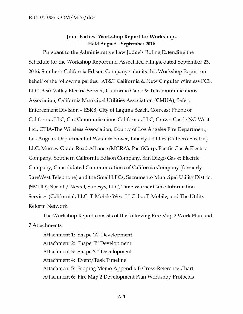
R.15-05-006 COM/MP6/dc3
A-1
Joint Parties’ Workshop Report for Workshops
Held August – September 2016
Pursuant to the Administrative Law Judge’s Ruling Extending the
Schedule for the Workshop Report and Associated Filings, dated September 23,
2016, Southern California Edison Company submits this Workshop Report on
behalf of the following parties: AT&T California & New Cingular Wireless PCS,
LLC, Bear Valley Electric Service, California Cable & Telecommunications
Association, California Municipal Utilities Association (CMUA), Safety
Enforcement Division – ESRB, City of Laguna Beach, Comcast Phone of
California, LLC, Cox Communications California, LLC, Crown Castle NG West,
Inc., CTIA-The Wireless Association, County of Los Angeles Fire Department,
Los Angeles Department of Water & Power, Liberty Utilities (CalPeco Electric)
LLC, Mussey Grade Road Alliance (MGRA), PacifiCorp, Pacific Gas & Electric
Company, Southern California Edison Company, San Diego Gas & Electric
Company, Consolidated Communications of California Company (formerly
SureWest Telephone) and the Small LECs, Sacramento Municipal Utility District
(SMUD), Sprint / Nextel, Sunesys, LLC, Time Warner Cable Information
Services (California), LLC, T-Mobile West LLC dba T-Mobile, and The Utility
Reform Network.
The Workshop Report consists of the following Fire Map 2 Work Plan and
7 Attachments:
Attachment 1: Shape ‘A’ Development
Attachment 2: Shape ‘B’ Development
Attachment 3: Shape ‘C’ Development
Attachment 4: Event/Task Timeline
Attachment 5: Scoping Memo Appendix B Cross-Reference Chart
Attachment 6: Fire Map 2 Development Plan Workshop Protocols

R.15-05-006 COM/MP6/dc3
A-2
Attachment 7: FSTP Workshop Agendas – Recaps/Notes – Attendee Lists
FIRE MAP 2 WORK PLAN SUMMARY
I. BACKGROUND AND OVERVIEW
A. The OIR and 7/15 Scoping Ruling
The California Public Utilities Commission (Commission) issued the Order
Instituting Rulemaking (OIR) 15-05-006 on May 7, 2015, which established the
preliminary scope of this proceeding including the development and adoption of
Fire Map 1. The Commission adopted Fire Map 1 in Decision (D.) 16-05-036. On
July 15, 2016, the Assigned Commissioner’s Scoping Memo and Ruling ((7/15
Scoping Ruling) was issued. The 7/15 Scoping Ruling established that the “next
step in this proceeding is to prepare the Fire Map 2 Work Plan, which will
provide a detailed road map for development and adoption of Fire Map 2.” The
7/15 Scoping Ruling further directed the Fire Safety Technical Panel (FSTP) to
convene and prepare a Fire Map 2 Plan using the same process as the Fire Map 1
Work Plan while addressing the matters identified in Appendices B and C of the
7/15 Scoping Memo.100
Appendix B of the 7/15 Scoping Memo provides in part that the
Fire Map 2 Plan:
…shall include a detailed work plan for the development, adoption, and implementation of a Fire Map 2 that: i. Incorporates Fire Map 1. ii. Covers the entire state. iii. Identifies the types and locations of overhead power-line facilities in the high fire-threat areas. iv. Identifies the types and locations of aerial telecommunications facilities in close proximity to overhead power-line facilities in the high fire-
100 7/15 Scoping Ruling at 5-7.

R.15-05-006 COM/MP6/dc3
A-3
threat areas. v. Integrates with the fire-prevention measures adopted in R.08-11-005 and this proceeding (R.15-05-006) that rely on fire-threat maps for their implementation. vi. Will be available to Commission staff, fire-safety agencies, and the public, while also protecting information about critical infrastructure or which may be proprietary.101
Appendix B also specifies a number of elements that should be included in
the work plan including; (i) the types of information, the level of detail and other
characteristics Fire Map 2 must possess (Item 2.i); (ii) proposals for contracting
with and funding any necessary technical experts for neutral review and the
funding of the same (Items 2ii-vi); a recommended schedule, recommended
procedures and needed Commission action (Items 2.vii and xii); frequency and
process for updating fire map to one is complete (Item 2.ix); and alternative
recommendations on any issues where parties cannot reach consensus (Item
2.xi).102 Appendix B also requires that Fire Map 2 be validated against historical
fire data and incorporate utilities’ knowledge of local conditions (Item 3).103 Of
note, Appendix B provides that “When possible, the Fire Map 2 Work Plan and
any alternatives to the Work Plan should enable the rapid development and
adoption of Fire Map 2” (Item 6).104 Appendix C sets forth a specific proposal for
the development of a statewide Fire Map 2.
101 7/15 Scoping Ruling, Items 1(i) – (vi) at B-1.
102 7/15 Scoping Ruling at B-1 – B.3
103 7/15 Scoping Ruling at B-3 – B-4.
104 7/15 Scoping Memo at b-4 (emphasis added).

R.15-05-006 COM/MP6/dc3
A-4
B. Revised Scoping Memo
Originally, there were two proposals for the Fire Map 2 Work Plan: (i) a
proposal by San Diego Gas & Electric Company (SDG&E) (involving a 3-step
map creation process); and (ii) the July 15 Scoping Memo, Appendix C
proposal. After considerable discussion and consideration at both public
workshops and within the FSTP Core Team,105 a decision was made to try to
combine the two approaches into a hybrid approach. While that work was
underway, a revised Scoping Memo proposal was issued on September 6, 2016
(Revised Scoping Memo). The Revised Scoping Memo proposed to “combine the
advantages of both [SDG&E and Appendix C] proposals” including, but not
limited to, the SDG&E proposal to use a 3-step map development process.
After clarification of the Revised Scoping Memo proposal with the ALJ, the
consensus of the group was generally to proceed with the process of the 3-step
map development as outlined in the Revised Scoping Memo,106 which would
involve the development of Shape A, followed by B and then by Shape C as
described below:
Shape A: The initial map based the inputs from Fire Map 1, Cal Fire’s FRAP map, historic fire perimeter data, and communities at risk from wildfire.
Shape B: Shape A further refined based on the utilities’ and other stakeholders’ knowledge of local conditions and fire hazard s/risks in particular areas.
105 The Core Team is composed of FSTP members or representatives of FSTP members with
unique knowledge and skill sets appropriate to the task of creating necessary technical details for the development of the FM 2 Plan.
106 The Revised Scoping Memo also provided that the FM 2 Plan should address the proposals in the Revised Scoping Memo in lieu of the original Scoping Memo Proposal set forth in Appendix C. See Revised Scoping Memo at 5.

R.15-05-006 COM/MP6/dc3
A-5
Shape C: Shape B further refined based on the overlay of utility facilities and other operational concerns. Shape C is the final Fire Map 2 work product.
C. S.B. 1463
In an email dated September 6, the assigned ALJ directed the parties to
include in the Fire Map 2 Plan provisions regarding compliance with S.B.
1463. S.B. 1463 would have required the Commission, “in consultation with the
Department of Forestry and Fire Protection, [to] prioritize areas in which
communities are subject to conditions that increase fire hazards associated with
overhead utility facilities.…” The legislation further would have required that
“[a]ny findings supporting a decision to approve the boundaries for areas
described in subdivision (a) shall describe how the commission incorporated the
concerns of local governments, fire departments, or both in determining those
boundaries.”
Consistent with the ALJ’s direction, the parties worked to incorporate
compliance with S.B. 1463’s requirements into the Fire Map 2 Plan. On
September 24, 2016, however, Governor Brown vetoed S.B. 1463 noting that the
Commission has already been working to prioritize areas with increased fire
hazards associated with overhead utility facilities through R.15-05-006 and that
this “deliberative process should continue and the issues this bill seeks to
address should be raised in that forum.”107 Because the veto occurred after the
conclusion of the workshops, the Fire Map 2 Plan set forth below continues to
reflect compliance with S.B. 1463 particularly with respect to the public notice
and input provisions (see Section III below) and the inclusion of communities at
107 Gov. Brown's S.B. 1463 veto message.

R.15-05-006 COM/MP6/dc3
A-6
risk from wildfires (CARs) in Shape A. See Section III below. If any workshop
participant or party believes that the work plan requires adjustment as a result of
the S.B. 1463 veto, any proposed adjustment should be addressed in comments
on the workshop report.
II. Roles And Responsibilities of the PDP, TRT and Territory Lead
The process described herein is based on existing peer review approaches
found in scientific, engineering, architectural and utility disciplines108 and
applicable requirements relating to stakeholder input. The composition and
roles of the groups are more specifically described as follows.
Peer Development Panel (PDP). The PDP has overall responsibility (working
with the Territory Leads) for developing statewide Shape B, and Shape C maps
which will ultimately form the basis for Fire Map 2. The PDP is primarily
composed of a small number of subject matter experts in areas directly related to
development of the maps and may include specialists in fire weather, fire
behavior, fire protection engineering, vegetation management, risk management,
forestry, structural engineering, utility and/or electrical engineering and
computational modeling (among others) who are willing to devote resources to
develop the statewide Fire Map 2 effort. SDG&E and Reax Engineering have
agreed to be the co-leads of PDP, and based on workshop discussions, it is
anticipated that the PDP will include personnel from PG&E, SDG&E, SCE,
PacifiCorp, Reax Engineering, AT&T, SMUD, LADWP, and possibly other
108 The use of peer panels is widely used to develop and reconcile technical issues in various
industries including the utility industry. See for example, the North American Transmission Forum http://www.natf.net/, and for the North American Electric Reliability Corporation http://www.nerc.com/Pages/default.aspx.

R.15-05-006 COM/MP6/dc3
A-7
organizations. The PDP co-leads will prepare the final PDP roster and will serve
the final PDP roster on the parties to the OIR.109
Territory Leads. The Territory Leads are the individuals or entities
responsible for assisting the PDP by developing territory-specific proposals for
Shape B and Shape C. The investor-owned utilities (IOUs) or publicly-owned
utilities (POUs) with facilities in a given territory will presumptively be the
Territory Lead for its service area, but are not required to be the lead.110 If there is
no utility with electric facilities in a given territory or the IOU or POU does not
want to take the lead for its territory, the PDP will be responsible for creating the
Shape B for that territory. Communications providers with facilities in the
territory and communications providers, IOUs, or POUs with facilities adjacent to
or in the territory can have specialists (with the appropriate technical expertise)
participate with the Territory Lead in the Shape B and C development effort for a
given territory. Parties participating as Territory Leads or working with the
Territory Leads in Shape B development are not necessarily a part of the
statewide PDP (but may be).111
Technical Review Team (TRT). The primary role of the TRT is to critically,
and independently, review the Shape B and Shape C development executed by
the PDP. Like the PDP, the TRT is to be composed of technical experts in areas
related to development of the maps and may include specialists in fire weather,
fire behavior, fire protection engineering, vegetation management, risk
109 The Assigned Commissioner or the Assigned ALJ will resolve disputes, if any, over the
composition of the PDP roster.
110 IOUs and POUs that choose not to be the lead would have input later in the process.
111 For example, Territory Leads not serving on the PDP might include Liberty and Bear Valley.

R.15-05-006 COM/MP6/dc3
A-8
management, forestry, structural engineering, utility and/or electrical
engineering, and computational modeling (among others) who are willing to
devote resources to develop the statewide Fire Map 2 effort. Collectively,
members of the TRT should have the expertise necessary to independently
execute the work being performed by the PDP in development of Fire Map 2.
During the September 21-22 workshops it was not possible to affirm that
the TRT will be led by CAL-FIRE. To the extent CAL-FIRE is willing and able to
lead this effort, it is proposed that it do so. It is further proposed that external
independent experts (to be funded and hired as specified in Section IV below)
would be provided to support CAL-FIRE’s effort -- much in the way that the Fire
Map 1 effort was led by CAL-FIRE using the support and guidance of an external
independent expert team. In addition to the TRT lead, representatives from state
agencies, city and county fire departments, qualified intervenors, and others as-
needed, may serve on the TRT, provided such participants possess the requisite
expertise. The TRT lead (e.g., CAL-FIRE) will prepare the final TRT roster and
serve the final TRT roster on the parties to the OIR.112
(*Non consensus Item) During the September 21-22 workshops, attendees
surmised that if CAL-FIRE or a Commission designee cannot lead the TRT, the
TRT could be led by a SED – ESRB engineer. However, SED was unable to affirm
its ability to take on this role and thus, there was no consensus reached on this
point among workshop participants. Alternate arrangements may be proposed
in comments to this Work Plan.
112 The Assigned Commissioner or the Assigned ALJ will resolve disputes, if any, over the
composition of the TRT roster.

R.15-05-006 COM/MP6/dc3
A-9
PDP/TRT Coordination and Decision Making. The TRT shall provide
expertise and resources for the purpose of technical review of PDP work
product. The TRT should communicate on a regular basis with the PDP and the
Territory Leads. The PDP and the TRT shall make good faith efforts to resolve
all disputes; obtaining, when necessary and appropriate, input from outside
resources including Territory Leads, academic experts, and consulting experts. It
shall be the goal of PDP/TRT interaction to reach agreement on all refinements
on Shape B so that rapid, final approved Fire Map 2 is facilitated. Only as a last
resort, shall the Commission be called upon to resolve technical disputes.
Stakeholders (Stakeholders). Stakeholders consist of entities that may be
subject to regulations based on Fire Map 2 (i.e., IOUs, POUs, and CIPs) as well as
other entities or interest groups (CAL-FIRE, local municipalities, land managers,
fire safe councils, community groups, TURN, etc.). Stakeholders will be
provided with the ability to publicly comment on the Fire Map 2 development
process but will not (unless they are also participating as a member of the PDP,
TRT or are a Territory Lead) play a role in the creation of Shapes A, B or C or Fire
Map 2 in general (which is the purview of the PDP) or their review and approval
(which is the purview of the TRT).
III. Shapes A, B and C Development, Review and Approval Processes
Overview of Fire Map 2 Plan Development. During the Workshops,
consensus was reached that Fire Map 2 will be developed in a three-step process
starting with the development of Shape A, which is then refined to a Shape B,
and then is further refined to Shape C. A summary of the development process
for each of the Shapes, along with the process for review and approval of the
shapes is set forth below. Additional details and technical guidance for (i) the

R.15-05-006 COM/MP6/dc3
A-10
creation of Shape A, (ii) moving from Shape A to Shape B, and (iii) moving from
Shape B to Shape C, is provided in Attachments 1, 2, and 3. The estimated time
for the completion of each of these steps is discussed below and a comprehensive
timeline is provided in Attachment 4.
Consensus was also reached at the workshops that the shapes will be
initially developed by the PDP, with assistance from Territory Leads. Shapes B
and C will then be reviewed by the TRT. The composition, roles, and
responsibilities of the PDP, the Territory Leads that will assist the PDP, and the
TRT are described in Section II above.
A. Shape A
Shape A Development Process. Under the Revised Scoping Memo, an initial
map (called Shape A) is to be the starting point for the development of Fire
Map 2. Shape A will be developed by Reax and SDG&E, generally using the
inputs specified in the Revised Scoping Memo proposal, as further refined and
clarified in this docket. Given the breadth of the specified Shape A inputs, it is
anticipated that Shape A will necessarily be over-inclusive with respect to the
areas identified and is not specifically designed to identify high fire areas or for
any purpose other than as a starting point for Fire Map 2.
The Fire Map 2 Plan proposes a 2-week process to develop Shape A.
Moreover, in order to “enable the rapid development and adoption of Fire Map
2” that is contemplated by the Revised Scoping Memo (at B-4), the Fire Map 2
Plan proposes that Shape A be developed in October 2016 —before the approval
of the Fire Map 2 Plan. Attachment 1 provides more detailed guidance
regarding the development of Shape A.
Shape A Review and Approval Process. Once Shape A is developed, it
will be provided to CAL-FIRE (or another neutral fire safety expert designated

R.15-05-006 COM/MP6/dc3
A-11
by the Commission) for confirmation that it was prepared consistent with the
factors specified in the Revised Scoping Memo.
Subject to the approval of the Fire Map 2 Plan, if CAL FIRE or Commission
designee agrees that that Shape A was properly prepared, Shape A will be filed
in the docket via a Tier 1 advice letter, which would be effective when filed,
pending Energy Division disposition. (See General Order (G.O.) 96-B, General
Rule 7.3.) Any person may protest or respond to the advice letter within 20 days
of the date of filing of the advice letter. (See G.O. 96-B, General Rule 7.4.) If a
protest is submitted, minor revisions to Shape A may be filed. If major revisions
are required, the Energy Division, in consultation with the assigned ALJ, will
determine whether the advice letter must be resolved by Commission resolution.
(See G.O. 96-B, General Rule 7.3.)
If CAL-FIRE or Commission designee believes that Shape A was not
properly prepared, Shape A will be referred back for refinement until either
(i) CAL-FIRE approves Shape A (at which point it will be filed as a Tier 1 Advice
letter in accordance with the procedure outlined above) or (ii) there is an impasse
reached. (See Section II above regarding PDP/TRT Coordination and Decision
Making.) The Work Plan proposes two weeks for CAL-FIRE’s review of Shape A.
B. Shape B
Shape B Development Process. The next step will be the creation of Shape
B. Shape B is a statewide map which will refine Shape A based on the utilities’
and other stakeholders’ knowledge of local conditions and fire hazards/risks in
particular areas. As the Revised Scoping Memo recognizes: “the area covered by
Shape B could be less than Shape A based on utilities’ demonstrable knowledge

R.15-05-006 COM/MP6/dc3
A-12
that Shape A overstates the fire hazards/risks in particular areas.”113
Additionally, tiers will be added to the Shape B map to delineate the level of risk
from utility fires in various areas of the state. Shape B boundaries may be
informed by additional data and consideration of fire rotation, probability and
consequence. Attachment 2 sets forth more detailed logistical and technical
guidance regarding the development of Shape B.
(i) Number of Tiers (*non-consensus item). It should be noted that consensus
was not reached on the appropriate number of tiers to be included in Fire Map 2.
The draft work plan that was circulated for discussion at the Workshops, and the
primary option discussed during the workshops, contemplated a 3-tier map. It
should be noted that a 3-tier approach is foundational to the methodology
described in the Scoping Memo and is used throughout the work plan. These
tiers have previously been described as:
Tier 3: Extreme
Tier 2: Elevated
Tier 1: Moderate (Not extreme or elevated. Baseline.)
Alternate Proposal. At the September 22, 2016 workshop, attendees
engaged in a brief discussion on the 3-tier mapping described above. AT&T
stated that it was premature to predetermine the number of tiers at this time and
offered that the number of tiers ultimately to be included in Fire Map 2 should be
left for the PDP to determine based on the level of differentiation observed after
the development of Shape A. AT&T’s comment was primarily borne out of
concern that the three-tier classification noted above essentially resulted in only
113 Revised Scoping Memo at 4.

R.15-05-006 COM/MP6/dc3
A-13
two substantive fire threat areas (extreme and elevated) and thus would
potentially place nearly all of the northern and central parts of the state’s high
fire district into a single “elevated” risk category despite what appear to be some
substantive differences between some of these areas. AT&T’s view is that such a
result would likely constrain the Commission’s and utilities’ ability to tailor
regulations pursuant to wildfire risks within a very large and diverse area. In the
course of the discussion on this alternate proposal, ALJ Kenney indicated that
different regulations may be applied to areas having different fire risks within
the same tier.
AT&T’s proposal directs the PDP to consider classification of the
“elevated” area in northern and central California into more layers if observation
of the underlying data and analysis justify such further identification of fire risk
zones within tiers to provide the Commission and utilities a means by which to
implement different regulations in areas having different fire risk levels within
the same tier.
(ii) Tier Definition. No official vote was taken at the closing workshop in
regards to the strict definition, or means of mapping, of each tier. Mapping the
tiers could be accomplished in a number of ways, including identifying
parameters related to fire probability and consequence (risk). If the Commission
adopts, for example, a 3-tier system, Tier 3 would represent the areas with the
highest risk (and require the most restrictive fire safety regulations), Tier 2 would
represent areas with lesser risk than extreme (but may require enhanced fire
safety regulations), and Tier 1 would represent areas with the least risk (and
current regulations are sufficient to protect public safety).
In order to ensure statewide consistency, the PDP will develop written
definitions for each tier. The specific criteria and parameters used to define

R.15-05-006 COM/MP6/dc3
A-14
Shape B tiers should be developed by the PDP in consultation with, and subject
to the approval of, the TRT. Generally, the highest tier should be associated with
areas where significant fire potential exists. Two examples of possible definitions
are provided below:
1. Areas where fire poses a significant threat to human life, has potential to damage/destroy multiple homes, or cause significant damage to the environment or other values at risk, or
2. Areas where fire consequences could be similar to the catastrophic fire Southern California firestorm of 2007.
In defining tiers, the PDP may assess potential fire consequences within
the geographic areas designated in the draft Shape C and develop tier definitions
consistent with fire risk in those tiers. Tier definitions should be developed in a
manner to facilitate statewide application. For Territory Leads using the optional
matrix methodology in Section 5, several tools are available for use including
Table 2 (Table of Values, which will need to be updated at project execution) and
Figure 1 (tier based metrics for the Tier Quadrant).
(iii) Timing. Once the number of tiers is determined in the Decision on the
Work Plan, and the tiers are defined by the PDP, Territory Leads (presumptively
the IOU or POU in a given service territory) will develop the Shape B proposal
(with tiers) for their service territory. It is anticipated that it will take 16 - 24
weeks for the development of a statewide Shape B with tiers.
Public Input on Shape B. The Fire Map 2 Plan developed at the workshops,
contemplated the need to obtain input on the fire map from “local governments,
fire departments or both” and communities at risk, as contemplated by S.B. 1463.
As noted above, to the extent that parties believe that the veto of this legislation
necessitates any changes to the public input process outlined below, that should
be reflected in their comments on the workshop report.

R.15-05-006 COM/MP6/dc3
A-15
The Draft Statewide Shape B Map will be made available for public review
and comment. Notice of availability of Draft Statewide Shape B Map will be
provided to all city and county points of contact designated for emergency
preparedness purposes pursuant to A.B.1650 (Pub. Util. Codes § 768.1) and to all
Communities at Risk (CARs).114 Notice will also be provided to all parties in
R.15-05-006 (CARs and emergency preparedness contacts will be included in the
term “Stakeholders,” as defined above).
The PDP will establish a mechanism for the Stakeholders to provide
comments and for those comments to be considered by the PDP. Any such
mechanism must allow for the tracking and documentation of Stakeholder
comments and responses thereto. The workshop participants recommend that
one or more workshops will be held to: (i) explain the Shape B development;
and (ii) explain how stakeholders can provide comment on the draft Shape B and
the justification they need to provide for any proposed changes to Shape B. The
PDP will consider all comments offered by Stakeholders, will make any
necessary adjustments to Shape B, and will prepare a Revised Draft Statewide
Shape B Map for review by the TRT. It is anticipated that the public input
process and resulting PDP refinement of Shape B will take approximately 4-8
weeks, depending on the level of comments received.
Shape B Review and Approval Process. The TRT will review the Revised
Draft Statewide Shape B Map and supporting material provided by the PDP. In
order to facilitate and expedite the TRT review and approval process, it is
anticipated that the PDP will regularly consult with the TRT about the
114 The list of California communities at risk from wildfire is available at:
http://osfm.fire.ca.gov/fireplan/fireplanning_communities_at_risk.

R.15-05-006 COM/MP6/dc3
A-16
methodology used to develop Shape B and on key questions. The TRT may also
request, in specific instances, that the PDP or Territory Leads provide additional
rationale or justification for certain boundaries or tier designations. The TRT
may propose modifications to the boundaries of certain proposed polygons
based on a written scientific rationale that is consistent the work plan
methodology and the requirements and scope of the rulemaking. An iterative
process of repeated refinement is contemplated until Shape B is sufficiently
refined to the TRT’s reasonable satisfaction (See Section II PDP/TRT Coordination
and Decision Making.) It is anticipated that the TRT review and approval of Shape
B will take approximately 1 - 4 weeks, assuming there are no matters for which
dispute resolution is required.
If the TRT approves Shape B the Shape B Map will be filed via a Tier 1
Advice letter in the docket,115 effective pending approval of Energy Division.
Any person (including Stakeholders) may protest or respond to the advice letter
within 20 days of the date of filing of the advice letter. (See G.O. 96-B, General
Rule 7.4.) If a protest is submitted, PDP/TRT may file minor revisions, or if
major revisions are required, the Energy Division, in consultation with the
assigned ALJ, will determine whether the advice letter must be resolved by
Commission resolution. (See G.O. 96-B, General Rule 7.3.)
If the TRT does not approve Shape B, a report will be filed in R.15-05-006
and any issues in dispute will be put out for comment and Commission
resolution (which may require evidentiary hearings).
115 A notice of availability of the map will be served on the service list for R.15-05-006 and on the
city and county points of contact designated for emergency preparedness purposes pursuant to A.B.1650 (Pub. Util. Codes § 768.1) and CARs identified in Section II above.

R.15-05-006 COM/MP6/dc3
A-17
C. Shape C
Shape C Development Process. The next step is the development of Shape C,
which is the final mapping product. Shape C will further refine Shape B, taking
into account the location of utility facilities and other operational concerns. It is
anticipated that the development of Shape C will take approximately 6-8 weeks.
The mechanics and criteria for Shape C development are set forth in
Attachment 3 and summarized below.
Territory Leads (in coordination with Communications Infrastructure
Providers (CIPs) will work with the PDP to refine Shape C into a final map
product. During the Shape B to Shape C process, Shape B will be overlaid with
utility infrastructure and minimal changes will be made Shape C to account for
facility location and operational concerns. The PDP will deliver the final Shape C
with justification for any changes to the TRT for review and approval. It is
anticipated that the TRT review and approval of Shape C will take
approximately 2 weeks.
Shape C Review and Approval Process. If the TRT approves of Shape C,
Shape C will be filed in the docket via a Tier 1 advice letter, which would be
effective when filed, pending Energy Division disposition. See G.O. 96-B,
General Rule 7.3. Any person (including individuals, groups, or organizations)
may protest or respond to the advice letter within 20 days of the date of filing of
the advice letter. (See G.O. 96-B, General Rule 7.4.) If a protest is submitted,
PDP/TRT may file minor revisions, or if major revisions are required, the Energy
Division, in consultation with the assigned ALJ, will determine whether the
advice letter must be resolved by Commission resolution. (See G.O. 96-B, General
Rule 7.3.)

R.15-05-006 COM/MP6/dc3
A-18
If the TRT is not satisfied that Shape C was properly prepared, Shape C
will be referred back to the PDP for refinement until either (i) TRT approves
Shape C (at which point it will be filed as a Tier 1 Advice letter in accordance
with the procedure outlined above) or (ii) there is an impasse reached. See
Section II, PDP/TRT Coordination and Decision Making. If an impasse is reached
then a report will be filed in R. 15-05-006 and any issues in dispute will be put
out for comment and Commission resolution (which may require evidentiary
hearings).
D. Tree Mortality.
The Revised Scoping Memo Proposal proposes that Fire Map 2 was a
separate layer for Tree Mortality that is independent of Shape A (and Shapes B
and C). This independent layer would consist of Tier 1 zones on the United
States Forest Service (USFS) and CAL-FIRE’s joint map of Tree Mortality High
Hazard Zones (HHZs). The PDP, in consultation with the TRT, should
undertake this work. Parties are encouraged to provide comments.
E. Publication / Dissemination of Fire Map 2
Once completed, Fire Map 2 will be disseminated in two forms:
1. High resolution .pdf file (no special software required for viewing)
2. Zip archive of native GIS files (when unzipped, requires GIS software and/or Google Earth for viewing)
A simple static web page will be created to provide basic information
regarding Fire Map 2 and static download links to each of the two above files
which should both be less than 50 MB in size. One example is FRAP’s Fire Threat
Map download page. (See attached link)
(http://frap.fire.ca.gov/data/frapgismaps/fire_threat_download) Ideally, the

R.15-05-006 COM/MP6/dc3
A-19
analogous Fire Map 2 web page would be hosted on a Commission or FRAP
server since there is already a precedent for hosting maps on both sites.
IV. APPENDIX B ITEMS
In addition to the key components of the map development itself,
Appendix B of the 7/15 Scoping Memo directed that the fire map work plan
address a number of other items. Many of those items are addressed above and
others are addressed below. For ease of review, attached as Attachment 5 is a
table that provides the locations where each of the Appendix B items is
addressed in the workshop report.
A. Protection of Critical Infrastructure Locations
Appendix B to 7/15 Scoping Ruling contemplated the fire map to will
identify both the (i) “types and locations of overhead power-line facilities in the
high fire-threat areas,” and (ii) “[t]he types and locations of aerial
telecommunications facilities in close proximity to overhead power-line facilities
in the high fire-threat areas.”116 The 7/15 Scoping Ruling further contemplates
that Fire Map 2 “vi. Will be available to Commission staff, fire-safety agencies,
and the public, while also protecting information about critical infrastructure or
which may be proprietary.”
During the workshops representatives of the communication
infrastructure providers (CIPs) recommended that in order to protect
information about critical communication infrastructure which is proprietary to
the CIPs and which raises national security concerns, Fire Map 2 should not—
116 7/15 Scoping Ruling at B-2.

R.15-05-006 COM/MP6/dc3
A-20
and cannot—include the location of CIP facilities consistent with both state and
federal precedent.117 Moreover, the consensus of the September 22, 2016
workshop participants was that the locations of communications facilities is not
necessary to develop Fire Map 2—especially since the map will include IOU
faculties. Thus, subject to further clarification from the Assigned Commissioner
or the Assigned ALJ, the CIPs do not anticipate that such information will be
provided.
1. Payment of Neutral Experts
2.ii, iv, v, vi (re contracting with and paying for neutral experts)
Assuming CAL FIRE is willing and able to lead the TRT, it is expected that
funding will be required to support CAL-FIRE’s use of experts. Experts will
assist CAL FIRE in its review of both the methodology to be used by the
Territory Leads and the PDP in developing Fire Map 2, as well as the proposed
map products developed by the Territory Leads and the PDP, as further
described elsewhere in the Fire Map 2 Plan.
It is contemplated that CAL FIRE will identify the resources and experts it
deems necessary to represent CAL FIRE on the TRT. The selection and
supervision of those resources would be directed by CAL FIRE and would be
secured under the following procurement procedures and funding mechanism
which are substantially similar to the procedures and funding mechanism
adopted by the Commission in connection with the development of Fire Map 1.
117 The CIPs provided a detailed but informal analysis of relevant state and federal law to the
workshop participants. The CIPs intend to update and refine this analysis in their comments filed on the workshop report.

R.15-05-006 COM/MP6/dc3
A-21
Based on CAL FIRE’s determination of a need for expertise and resources
and the expectation that expenses would be limited, consistent with the funding
arrangements that supported the engagement of the independent expert team in
the Fire Map 1 development phase, the three largest IOUs, PG&E, SCE and
SDG&E, have volunteered to pay the cost of such resources—subject to the
following additional provisions:
1. Total expenditures for any funding of needed experts or resources, as determined by CAL-FIRE, up to and including the creation of a final statewide Fire Map 2, will not exceed the sum of the balance of the remaining funds authorized for Fire Map 1 and $250,000 unless the requirements of No. 5 (below) are met.
2. The payment of costs by PG&E, SCE and SDG&E for the limited purpose identified in No. 1 shall have no precedential value as to the percentage of cost responsibility or non-responsibility of other parties for any other aspects of this proceeding.
3. PG&E, SCE and SDG&E may expense these costs to their Fire Hazard Prevention Memorandum Accounts (FHPMAs) that are described in D.12-01-032 at pages 153-156.
4. Based on the fact that the need for the TRT expertise will be determined by CAL-FIRE and that the work will be directed and reviewed by CAL-FIRE, expenditures by PG&E, SCE and SDG&E that do not exceed the cost cap specified in No. 1 shall be presumed reasonable by the Commission.
5. CAL-FIRE and/or SED must seek Commission approval to exceed the cost cap, if needed. The cost responsibility for any additional expenditures above the initial cost cap specified in No. 1 will be considered at that time. If PG&E, SCE and SDG&E again volunteer to pay the cost of any additional expert expense, any costs incurred and booked in the respective FHPMAs will be presumed reasonable up to any new/revised cost cap authorized by the Commission.
6. Arrangement of Contract Relationships

R.15-05-006 COM/MP6/dc3
A-22
Parties have expressed a preference to simplify the contract structure
based off the experiences encountered with Map 1 experts. Alternatives are being
explored at the time of this reports submission. There are three potential
solutions. The quantity of expert vendors required by the TRT to support the
review process is yet to be determined and significant in recommending which
approach will be most efficient.
a. Use the same contract structure as Map 1. While complex it has proven to be effective.
b. Assign one IOU as a lead to prepare and execute the appropriate contract or contracts under terms and conditions appropriate to TRT requirements118 and the utility’s normal contracting practices.119 The contractor(s) would be required to record the billable cots of its time, materials and expenses, which would be reviewed for accuracy and reasonableness by the TRT and/or SED. After approval from the TRT and/or SED, the contractor would directly bill the lead IOU, which in turn will bill the two other IOU’s for their respective proportionate shares of the total cost paid to vendors. PG&E, SCE and SDG&E agree to share the total billable costs using the following allocation: PG&E (49%), SCE (41%) and SDG&E (10%). This allocation is based on 2011 annual electric revenue as an allocation proxy.
c. Assign one expert vendor as a lead to prepare and execute the appropriate contract and sub-contracts with other expert vendors under terms and conditions appropriate to TRT
118 As an example, the contract would provide that services would be subject to the supervision
of CAL-FIRE and any limits as to time, expenses and costs to be determined by CAL-FIRE, with the understanding that payment would be subject to the five provisions above or any provisions adopted by the Commission
119 As an example, IOUs routinely include provisions encourage any contractor, to the extent subcontractors are engaged, to utilize Commission-audited firms owned by women, minorities and/or disabled veterans.

R.15-05-006 COM/MP6/dc3
A-23
requirements120 and the utility’s normal contracting practices.121 The lead contractor manages and makes payment to the sub-contractors. The lead contractor would be required to record the billable cots of its time, materials and expenses, which would be reviewed for accuracy and reasonableness by the TRT and/or SED. After approval from the TRT and/or SED, the contractor would directly invoice the three IOU’s. The lead contractor would have contracts in place with PG&E, SCE and SDG&E. The IOU’s agree to share the total billable costs using the following allocation: PG&E (49%), SCE (41%) and SDG&E (10%). This allocation is based on 2011 annual electric revenue as an allocation proxy.
B. Other Appendix B Items
2.ix (updates of Map 2)
Fire Map 2 can be incorporated into G.O. 95 and other G.O.s, if applicable,
by way of reference to a webpage that can be accessed via the Commission’s
website. SED is reviewing the requisite technical and administrative
requirements of this approach. Parties may suggest additional means for
incorporating Fire Map 2 into the G.O.s by submitting comments to this
Fire Map 2 Plan.
It is recommended that the Fire Map 2 be updated in ten (10) year cycles as
part of a rulemaking process that provides for public input, expert review and
workshops that will (i) examine whether to incorporate recent advances, if any,
in fire science modeling, (ii) incorporate recent fire history, and (iii) address any
notable changes in the fuel landscape, urban growth and utility infrastructure
and operational practices.
120 See fn. 20.
121 See fn. 21.

R.15-05-006 COM/MP6/dc3
A-24
Parties may suggest additional means for incorporating Fire Map 2 into the
G.O.s by submitting comments to this Fire Map 2 Plan.
2.x (CEQA)
The development of Fire Map 2 and this Proposed Work Plan are exempt
from environmental review under Section 15378 of the CEQA Guidelines
because their approval and adoption do not constitute “projects” under the terms
of the Act and will not have any potentially significant impact on the
environment. Thus, the Proposed Work Plan schedule does not provide for a
CEQA review.
3.(iii) (Butte fire inclusion)
Consideration of the fire hazards associated with historical power-line
fires, including the Butte Fire, is addressed in both the Shape A and Shape B
development processes described in this Fire Map 2 Plan.
3.iv (Laguna Beach as High)
The fire threat classification of the geographic area comprising and
surrounding the City of Laguna Beach will be evaluated in the same manner as
other geographic areas are evaluated using the Shape B methodology described
in this Work Plan. In addition, parties, including the City of Laguna Beach, SCE
and SDG&E, may address the issue of fire threat classification and/or Shape B
methodology by submitting comments to this Fire Map 2 Plan.
3.vii and 1.v (transitioning regulations to Fire Map 2)
The FSTP did not address this Appendix B item in during the workshops.
It is expected that the fire hazard tiers developed as part of the Fire Map 2
process will be defined and calibrated and, accordingly, may be correlated with
the fire hazard designations utilized in the interim fire-threat maps. Parties may

R.15-05-006 COM/MP6/dc3
A-25
address this issue more specifically by submitting comments to this Fire Map 2
Work Development Plan.
V. CONCLUSION AND ACKNOWLEDGEMENTS
Over the course of recent months, the FSTP has worked diligently to
complete the Fire Map 2 Plan. Nearly ten full days of noticed public meetings
were convened, including the initial FSTP teleconference on August 1, in-
person/teleconference workshops held on August 11, August 18-19, August 29-
30, September 7-9, and September 21-22, and a final teleconference on October 5,
to review and discuss this workshop report prior to filing. Additionally,
numerous teleconferences and in-person meetings were convened by FSTP’s
Core Team, many of whom also contributed to the content and refinement of this
Workshop Report.
The FSTP wishes to recognize the efforts of SDG&E for their original
proposal and initiative in promoting a ‘hybrid’ Fire Map 2 proposal; the
Commission’s Legal Division, Safety Enforcement Division, the Commission’s
technical staff; as well as PG&E, AT&T, and SCE for helping organize and host
the above referenced in-person workshops, teleconferences, and meetings.
The FSTP also wishes to recognize the efforts of the Core Team and Editing
Team members who have worked tirelessly before, during and after the
workshops to refine the content of this work plan and reach consensus on
material items both small and large.
Finally, the FSTP gratefully acknowledges the participation of
ALJ Timothy Kenney and Ms. Charlyn Hook, advisor to Commissioner Florio,
for their valuable input and encouragement throughout.

R.15-05-006 COM/MP6/dc3
A-26
Respectfully submitted,
FRANK A. MCNULTY
ALLAN D. JOHNSON
/s/ Allan D. Johnson
By: Allan D. Johnson
Attorneys for
SOUTHERN CALIFORNIA EDISON COMPANY
2244 Walnut Grove Avenue
Post Office Box 800
Rosemead, California 91770
Telephone: (626) 302-6735
Facsimile: (626) 302-6693
E-mail:[email protected]
October 7, 2016
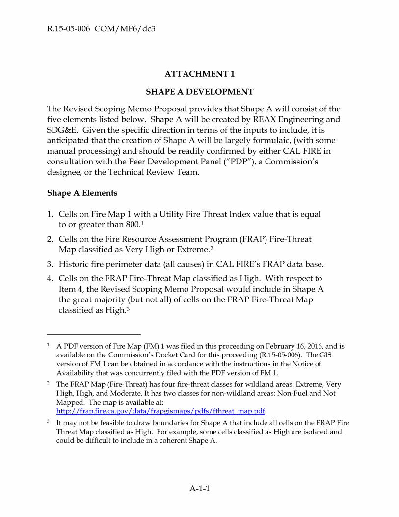
R.15-05-006 COM/MF6/dc3
A-1-1
ATTACHMENT 1
SHAPE A DEVELOPMENT
The Revised Scoping Memo Proposal provides that Shape A will consist of the five elements listed below. Shape A will be created by REAX Engineering and SDG&E. Given the specific direction in terms of the inputs to include, it is anticipated that the creation of Shape A will be largely formulaic, (with some manual processing) and should be readily confirmed by either CAL FIRE in consultation with the Peer Development Panel (“PDP”), a Commission’s designee, or the Technical Review Team. Shape A Elements 1. Cells on Fire Map 1 with a Utility Fire Threat Index value that is equal
to or greater than 800.1
2. Cells on the Fire Resource Assessment Program (FRAP) Fire-Threat Map classified as Very High or Extreme.2
3. Historic fire perimeter data (all causes) in CAL FIRE’s FRAP data base.
4. Cells on the FRAP Fire-Threat Map classified as High. With respect to Item 4, the Revised Scoping Memo Proposal would include in Shape A the great majority (but not all) of cells on the FRAP Fire-Threat Map classified as High.3
1 A PDF version of Fire Map (FM) 1 was filed in this proceeding on February 16, 2016, and is
available on the Commission’s Docket Card for this proceeding (R.15-05-006). The GIS version of FM 1 can be obtained in accordance with the instructions in the Notice of Availability that was concurrently filed with the PDF version of FM 1.
2 The FRAP Map (Fire-Threat) has four fire-threat classes for wildland areas: Extreme, Very High, High, and Moderate. It has two classes for non-wildland areas: Non-Fuel and Not Mapped. The map is available at: http://frap.fire.ca.gov/data/frapgismaps/pdfs/fthreat_map.pdf.
3 It may not be feasible to draw boundaries for Shape A that include all cells on the FRAP Fire Threat Map classified as High. For example, some cells classified as High are isolated and could be difficult to include in a coherent Shape A.

R.15-05-006 COM/MP6/dc3
A-2
5. The intersection of the following areas associated with communities at risk from wildfire (“CARs”): 4
a. Areas classified as “Very High” on CAL-FIRE’s map of Fire Hazard Severity Zones (“FHSZs”),5 and
b. Areas within the boundaries of communities on record with CAL-FIRE as being at risk from wildfire and to a distance of 1.5 miles outside the edges of the CARs boundaries.6 In cases where there are no municipal boundaries for a particular CAR, the area for the CAR that would be used to develop Shape A would be the CAR’s point location on CAL FIRE’s statewide map of CARs7 plus a radius of 1.5 miles around the point location.8
During the workshops, SDG&E reported that CAL FIRE had produced a map of all the CARs that it would make available to the PDP for Shape A development.
4 There may be some CARs that do not meet the intersecting criteria in Item 5 (i.e., none of the
CAR is within an area classified as “Very High” on CAL-FIRE’s map of Fire Hazard Severity Zones) and thus not included in Shape A.
5 Maps of FHSZs are available at: http://www.fire.ca.gov/fire_prevention/fire_prevention_wildland_zones_maps.
6 There are approximately 1,329 communities currently on record with CAL-FIRE as being at risk from wildfire, including the City of Laguna Beach. The list is available at:
http://osfm.fire.ca.gov/fireplan/fireplanning_communities_at_risk.
7 A PDF version of CAL-FIRE’s statewide map of CARs point locations is available at: http://frap.fire.ca.gov/data/frapgismaps/pdfs/comrisk_map.pdf.
8 It would only be necessary to determine CAR boundaries for those CARs that are not otherwise included in Shape A as a result of applying Factors 1 – 4.

R.15-05-006 COM/MP6/dc3
2-2-1
ATTACHMENT 2
SHAPE ‘B’ DEVELOPMENT
1.0 INTRODUCTION
This Attachment 2 describes how Shape A will be refined into Shape B and is based on the assumption that Shape A has been successfully developed and approved as part of a separate work stream.
Section 2.0 describes roles and responsibility of the participants, Section 3.0 describes the logistical framework, Section 4.0 describes the technical framework for development and approval of Shape B, and Section 5.0 describes an optional methodology.
As described in Section 4.0, Territory Leads will have primary responsibility to develop and refine Shape A for their assigned territories and, as described in Subsection 4.3, will be responsible for drafting and compiling a written proposal for submission to the peer development panel (PDP), which, at each Territory Lead’s option, can take the form of:
A narrative describing adjustments on the basis of considerations described in Table 1 and the tier definitions developed as described in Subsection 4.1;
A matrix driven approach that evaluates key criteria as described in Section 5.0; or
A combination of the narrative and matrix approaches.
2.0 ROLES AND RESPONSIBILITIES
To ensure consistency, transparency and technical rigor, this portion of the Fire Map 2 development process (i) will be executed by the PDP, which will assign territory specific mapping roles to Territory Leads, (ii) will be reviewed and approved by a Technical Review Team (TRT), and (iii) will provide for stakeholder (Stakeholder) input. The roles and responsibilities of each of these entities are set forth in the Work Plan Summary.

R.15-05-006 COM/MP6/dc3
2-2-2
3.0 LOGISTICAL FRAMEWORK FOR SHAPE B CREATION
3.1 Overview of Shape B Creation and Adoption
As described in more detail in Section 4, the PDP, with heavy reliance on the Territory Leads, will create statewide Shape B polygons and designate the appropriate tier level. Proposed Shape B polygons will be internally reviewed and approved by the PDP before a statewide Shape B map is submitted for Stakeholder and TRT review. After the TRT reviews Shape B, it will be submitted to the Commission for approval. The review and approval process is described in more detail in Section III.B of the Fire Map 2 Work Plan Summary.
3.2 Protocol The adopted schedule assumes there are no disputes that require an
evidentiary hearing or a Commission decision. and Management Process
The PDP will create internal protocols and management processes that promote:
Transparency to TRT
Version control (described in Section 3.2.1 below)
Documentation (feedback/review)
3.2.1 Web-based integrated project management / version control software
It is proposed that the Shape B creation process be executed with web-based integrated project management / version control software. This makes the Shape B creation process completely transparent and provides a mechanism for stakeholders, municipalities, etc. to provide input to or comment on the Shape B creation process.
The concept of version control is prevalent in software development. With version control, each revision or modification to a project’s source code is tracked. Particularly for open source projects, version control is often integrated with web-based project management and bug/issue tracking systems.
One possibility is to create a web site based on Trac (https://trac.edgewall.org/) with Subversion (https://subversion.apache.org/) for version control. This software has basic Wiki functionality, user accounts, and issue tracking. An example of a live site using this software combination can be seen at http://reaxengineering.com/trac/gpyro. Such a web site could be hosted on a virtual server for a cost of approximately $500 per year. Another possibility is to host the site on GitHub (https://github.com).

R.15-05-006 COM/MP6/dc3
2-2-3
Using this type of software allows each member of the PDP and TRT and each Territory Lead (including those providing assistance to each Territory Lead)1 to create accounts that make it possible to initiate and comment on “tickets” that feature proposed changes. As an example, a Territory Lead or the PDP may propose a modification to Shape B by creating a ticket, attaching a GIS shapefile for the polygon being proposed for change, and providing a written justification for the proposed change. This ticket and proposed change would be immediately viewable by anyone with a web browser. The TRT would be able to comment on the proposed revision by adding a comment to the ticket. The TRT could ask questions, request additional information, accept the revision, or reject the revision. In this way, the entire process of Shape B creation is well documented.
4.0 TECHNICAL FRAMEWORK FOR SHAPE B CREATION
4.1 Step 1: Calibration and Tier Definition
4.1.1 The Number of Tiers (**Non-Consensus Item)
It should be noted that a 3-tier approach is foundational to the Work Plan. However, consensus was not reached on the appropriate number of tiers to be included in Fire Map 2. The draft Work Plan that was circulated for discussion at the workshops, and the primary option discussed during the workshops, contemplated a 3-tier map. These tiers have previously been described as:
Tier 3: Extreme
Tier 2: Elevated
Tier 1: Moderate (Not extreme or elevated. Baseline.)
Alternate proposal (**Non-Consensus Item) : To provide the Commission and utilities a means through which different regulations could be implemented in areas having different fire risk levels within the same tier, the PDP may consider further classification of Tier 2 into sub tiers—if the underlying data and analysis justify such further identification of fire risk zones. (See additional details on AT&T’s alternate proposal in Summary of Fire Map Work Plan.)
1 It is possible that Stakeholders could also use this or another web-based integrated system;
this is an issue to be determined by the PDP.

R.15-05-006 COM/MP6/dc3
2-2-4
4.1.2 Tier Definitions
No official vote was taken at the closing workshop in regards to the strict definition, or means of mapping, of each tier. Mapping the tiers could be accomplished in a number of ways, including identifying parameters related to fire probability and consequence (risk). If, for example, the Commission adopts a 3-tier system, Tier 3 would represent the areas with the highest risk (and require the most restrictive fire safety regulations), Tier 2 would represent areas with lesser risk than extreme (but may require enhanced fire safety regulations), and Tier 1 would represent areas with the least risk (and current regulations are sufficient to protect public safety).
In order to ensure statewide consistency, the PDP will develop written definitions for each tier. The specific criteria and parameters used to define Shape B tiers should be developed by the PDP in consultation with, and subject to the approval of, the TRT. Generally, the highest tier should be associated with areas where significant fire potential exists. Two examples of possible definitions are provided below:
1. Areas where fire poses a significant threat to human life, has potential to
damage/destroy multiple homes, or cause significant damage to the
environment or other values at risk, or
2. Areas where fire consequences could be similar to the catastrophic fire
Southern California firestorm of 2007.
Tier definitions should be defined in a manner that can be applied statewide using the “narrative” approach. In addition, to support the efforts of Territory Leads using the optional matrix methodology described in Section 5, the PDP should, based on the final tier definitions, update the parameters for Low, Medium and High set forth in the Table of Values, Table 2 and the tier based metrics for the Tier Quadrant, depicted in Figure 1.
4.2 Step 2: Create Statewide Refinements to Shape A
The (large group) PDP will execute statewide GIS operations to “carve out” areas of Shape A that are incapable of supporting propagating fires, perhaps using a burnable/non-burnable mask from LANDFIRE or CalVeg/FVEG. This includes waterbodies, barren cover types, irrigated agricultural land, and high-density urban areas. A raster sieve function could be used to prevent small groups of non-burnable pixels from being included in the non-burnable mask.

R.15-05-006 COM/MP6/dc3
2-2-5
After areas incapable of propagating fire have been removed from Shape A, the result is a first draft of Shape B. The PDP’s next step is to further refine and render Shape B on a statewide basis to: (i) include and exclude polygons from Shape B based on demonstrable incorrect logic in Fire Map 1 or FRAP Fire Threat Map, e.g., Northern California bias and (ii) to exclude cells that are isolated spatially.
Before moving on to Step 3, which involves a refinement process that is specific to the region assigned to each Shape B Territory Lead, the PDP should consult with the TRT regarding the work performed in Step 2.
4.3 Step 3: Territory Leads Develop Refinements to Shape B and Propose Tier 2 and Tier 3 Polygons for their Assigned Geographical Areas
Each Territory Lead will develop a proposed Shape B for its assigned territory.
The proposed Shape B may contain inclusions or exclusions from the Shape B as specified in the table below2 and will include proposed tier designations for specified polygons based on the tier definitions established in Step 1. Alternatively, the Territory Lead may use the matrix methodology described in Section 5 as the basis for including or excluding geographical areas from Shape B and proposing tier designations to specified polygons.
2 Application of the considerations in the table requires that local knowledge be combined
with reasonable judgment. The greater the degree to which these considerations apply to an area under review, the greater the likelihood that the considerations will support a proposed change.

R.15-05-006 COM/MP6/dc3
2-2-6
Table 1. Inclusion / Exclusion Criteria for Shape B
Considerations for movement either way
Considerations for including an area into Shape B
Considerations for removing an area from Shape B (where there is no significant fire history and no
proximity to area at risk or community at risk)
Burnable/un-burnable mask (CalVeg)- 2015 CalVeg data was used as a ‘mask’ and the area under consideration needs to be moved based on whether or not it is covered by burnable vegetation. It was either included or excluded from Shape A in the course survey and this burnable/unburnable “test” will help determine its final disposition.
Community at risk not captured
elsewhere- This area is covered by the CAR shape but did not get picked up when drawing the initial Shape A. It might not have had significant fire history or Fire Threat score, or its Map 1 signal fell below a visual threshold. Nonetheless, it falls within CAR and therefor needs to be included into Shape B.
Cells that are isolated spatially- These areas (cells) were captured ‘wholesale’ as part of one or more of the building block layers but due to their spatially isolated nature, they don’t necessarily require consideration for enhanced regulations. They may be surrounded by cells of lesser threat, they may not represent significant fire history or they may not be proximate in a significant way to CAR or AAR. From an operational perspective, these cells may just be too small or isolated to require consideration for enhanced regulation.
Known land use changes- This area has undergone significant land use changes such as previously irrigated cropland reverting to a burnable landscape, or, an area of recent, significant construction/development.
Demonstrable incorrect logic in Fire Map 1 or FRAP Fire Threat Map, e.g.,
Northern California bias - This area lacked signal in one (or more) of the foundational layers but is known to represent significant threat of wildfire should an ignition occur. There may have been a singular, significantly damaging fire that is spatially removed from the preponderance of fire perimeters, or possibly, the area may have been omitted from Map 1 signal simply because of weather anomalies.
Cells are too small to be significant when taken individually or in small
clusters- This guideline does not differ significantly from the one immediately above.
Known specific hazard such as fuel accumulations, ingress/egress issues,
proximity to dense assets at risk- These areas are likely to be small. The factors that make them candidates for inclusion into Shape B were not necessarily mapped or quantified in any of the foundational layers; assets at risk and ingress/egress for firefighters are but two examples.
Demonstrable incorrect logic in Fire Map 1 or FRAP Fire Threat Map, e.g.,
Northern California bias - A good example of this type of area is the north coast where significant fire signal is observed in Fire Map 1 but actual conditions are known to offer significantly less fire threat.
Past catastrophic fires or exceptionally dense fire history- For some reason, the Shape A step did not capture an area of frequent or repeated burns, or there are known, significant fires on the landscape here but they are small in size or isolated from the main fire history footprint.
Scarcity of Assets at Risk- These areas, although they may be good candidates for enhanced regulations, do not abut areas of significant CAR/AAR nor do they have a history damaging fires originating in them.
Lowered hazard due to fuel and weather - These areas present a lower requirement for enhanced regulations because of fuel or weather considerations not elsewhere captured.

R.15-05-006 COM/MP6/dc3
2-2-7
Good ingress/egress- These areas are well served by larger, more consistent traffic corridors (freeways, highways) to allow for either fire-fighting resource ingress or civilian egress. This travel corridor is sufficient to allow for a lessened need for enhanced regulation.
Since Shape B Tier 3 is based on a specific definition, it may be created in parallel with applying inclusions and exclusions from Shape B. For example, if Shape B Tier 3 is defined to be areas where elevated hazard associated with ignition and rapid spread of power line fires due to strong winds, abundant dry vegetation, or other environmental factors may negatively impact communities, structures, or people, then each Territory Lead should identify areas where communities, structures, or people (through communities at risk or wildland urban interface / intermix layers) intersects areas possessing the hazards above (using Fire Map 1 and possibly other data sources).3
Each Territory Lead will submit to the PDP one or more proposals for Shape B for the applicable geographic area which proposal(s) shall be in such form as is directed by the PDP. Such submissions may include:
A GIS shapefile for proposed Shape B in the territory;
An image comparing the Step 2 version of Shape B to the Step 3 version of
Shape B for the territory for which the proposal is submitted; and
Reasonable justification / rationale for the proposed Shape B, setting forth
in reasonable detail:
o A narrative describing adjustments on the basis of considerations
described in Table 1 and the tier definitions developed as described
in Step 1;
o A matrix driven approach that evaluates key criteria as described in
Section 5; or
o A combination of the narrative and matrix approaches.
3 It is contemplated that additional information such as the location of Wildland Urban
Interface (WUI) zones on the basis of census data (e.g., http://silvis.forest.wisc.edu/maps/wui) may also be used to develop Shape B and differentiate between tiers.

R.15-05-006 COM/MP6/dc3
2-2-8
Each Territory Lead will submit its proposal package to the PDP within the timeframe indicated on the work plan schedule. Each proposal will be reviewed by the members of the PDP who will confer with the Territory Lead. Each proposal will be either referred back to the applicable Territory Lead for further consideration or approved by the PDP. This process will repeat until the PDP approves a revised, statewide Shape B. The TRT may be consulted on proposals unresolved by the Territory Leads and PDP.
4.4 Step 4: Stakeholder Input Process
Once the PDP has approved all of the proposals submitted by the Territory Leads, the PDP will compile a proposed statewide map for comment by the Stakeholders and solicit Stakeholder comment. Specifically:
(1) Map Availability: The maps will be made available for public review and
comment on a website (for example GitHub)
(2) Notice: Notice of availability of Draft Statewide Shape B Map and
workshop[s] will be provided to all city and county points of contact
designated for emergency preparedness purposes pursuant to A.B. 1650
(P.U. Codes section 768.1) and to all Communities at Risk (CARs). Notice
will also be provided to all parties in R.15-05-006.
(3) Workshops: It is recommended that one or more workshops will be held
to: (i) explain the Shape B development; and (ii) explain how stakeholders
can provide comment on the draft Shape B and the justification they need
to provide for any proposed changes to Shape B.
(4) Comment on Draft Shape B Map: The PDP will establish a mechanism for
the Stakeholders to provide comments and for those comments to be
considered by the PDP. The mechanism must allow for the tracking and
documentation of any stakeholder comments and responses thereto.
(5) Draft Shape B Map Modification: The PDP will consider all comments
offered by stakeholders, will make any necessary adjustments to Shape B
and will prepare a Revised Draft Statewide Shape B Map for review by the
TRT.
4.5 Step 5: TRT Review and Adoption of Shape B
After the statewide PDP makes any adjustments to the map to address local concerns, the Shape B map will be sent to the TRT for review and approval. In

R.15-05-006 COM/MP6/dc3
2-2-9
addition, the PDP shall deliver to the TRT a complete set of all the proposals submitted to the PDP by the Territory Leads and the PDP’s responses to any Stakeholder comment. The TRT may also request, in specific instances, that the applicable Territory Leads (i) provide additional rationale/justification for certain boundaries or tier designations and/or (ii) modify the boundaries of certain proposed polygons based on a written scientific rationale that is consistent the work plan methodology and the requirements and scope of the rulemaking. An iterative process of repeated refinement is contemplated until Shape B is sufficiently refined to the TRT’s reasonable satisfaction or any impasses are resolved and Shape B is provided to the Commission for approval. See Summary of Fire Map Workplan 2 for details on Commission Review and Approval Process and TRT/PDP dispute resolution process.
4.6 Process Flow Chart
A process flow chart for the process described in this Section 4 is depicted graphically in 3. It is anticipated that it will take between 16 and 24 weeks for the development of a statewide Shape B with tiers.
5.0 OPTIONAL MATRIX METHODOLOGY
As indicated in Subsection 4.3, Territory Leads may develop and support proposed changes to Shape B and tier designations using the matrix methodology set forth in this Section 5. Generally, this methodology will result in support for inclusion of geographic areas within Shape B where:
1) Populations at high risk are not included in Shape A; and
2) Areas having a history of past catastrophic fires were not included in Shape A.
Conversely, this methodology should result in support for the exclusion of geographic areas where:
1) Shape A shows isolated or small clusters of cells that do not pose a risk of
fire spread;
2) Shape A provides designations not supported by fire history and/or
climatology.
5.1 Optional Matrix Methodology Step 1: Define Candidate HEZs
The Shape B Territory Lead will begin developing Shape B by within the assigned territory by partitioning the applicable portion of Shape A into candidate
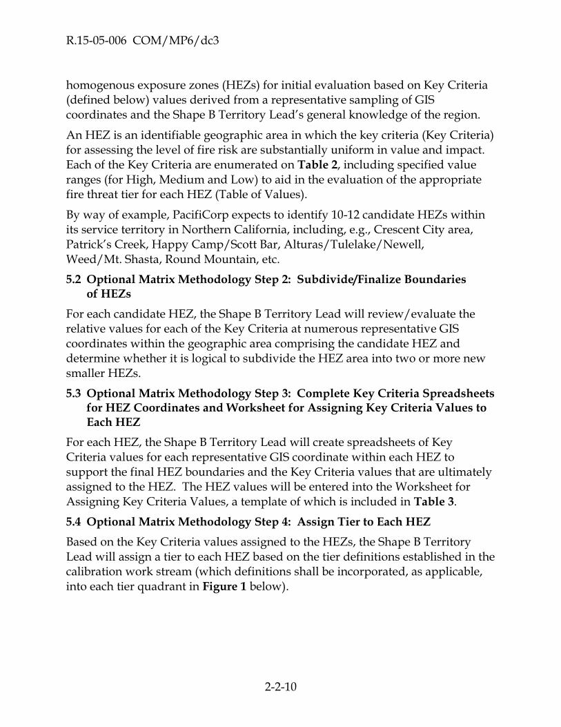
R.15-05-006 COM/MP6/dc3
2-2-10
homogenous exposure zones (HEZs) for initial evaluation based on Key Criteria (defined below) values derived from a representative sampling of GIS coordinates and the Shape B Territory Lead’s general knowledge of the region.
An HEZ is an identifiable geographic area in which the key criteria (Key Criteria) for assessing the level of fire risk are substantially uniform in value and impact. Each of the Key Criteria are enumerated on Table 2, including specified value ranges (for High, Medium and Low) to aid in the evaluation of the appropriate fire threat tier for each HEZ (Table of Values).
By way of example, PacifiCorp expects to identify 10-12 candidate HEZs within its service territory in Northern California, including, e.g., Crescent City area, Patrick’s Creek, Happy Camp/Scott Bar, Alturas/Tulelake/Newell, Weed/Mt. Shasta, Round Mountain, etc.
5.2 Optional Matrix Methodology Step 2: Subdivide/Finalize Boundaries of HEZs
For each candidate HEZ, the Shape B Territory Lead will review/evaluate the relative values for each of the Key Criteria at numerous representative GIS coordinates within the geographic area comprising the candidate HEZ and determine whether it is logical to subdivide the HEZ area into two or more new smaller HEZs.
5.3 Optional Matrix Methodology Step 3: Complete Key Criteria Spreadsheets for HEZ Coordinates and Worksheet for Assigning Key Criteria Values to Each HEZ
For each HEZ, the Shape B Territory Lead will create spreadsheets of Key Criteria values for each representative GIS coordinate within each HEZ to support the final HEZ boundaries and the Key Criteria values that are ultimately assigned to the HEZ. The HEZ values will be entered into the Worksheet for Assigning Key Criteria Values, a template of which is included in Table 3.
5.4 Optional Matrix Methodology Step 4: Assign Tier to Each HEZ
Based on the Key Criteria values assigned to the HEZs, the Shape B Territory Lead will assign a tier to each HEZ based on the tier definitions established in the calibration work stream (which definitions shall be incorporated, as applicable, into each tier quadrant in Figure 1 below).
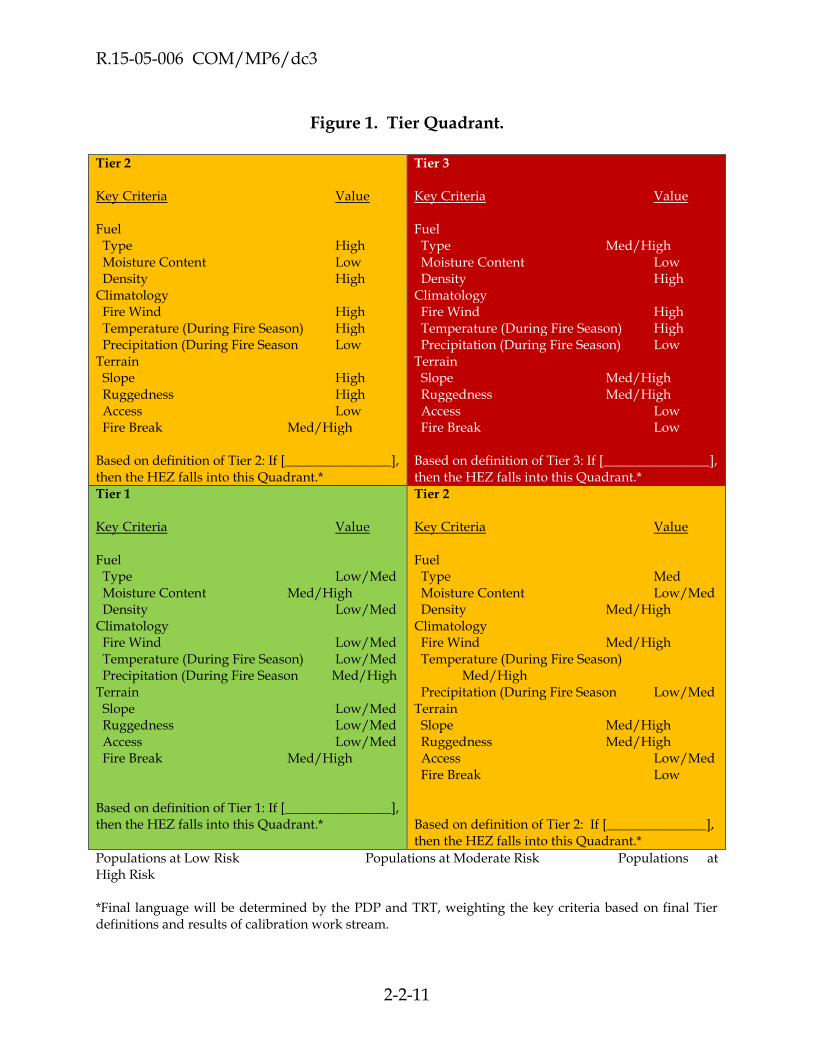
R.15-05-006 COM/MP6/dc3
2-2-11
Figure 1. Tier Quadrant. Tier 2
Key Criteria Value Fuel Type High Moisture Content Low Density High Climatology Fire Wind High Temperature (During Fire Season) High Precipitation (During Fire Season Low Terrain Slope High Ruggedness High Access Low Fire Break Med/High Based on definition of Tier 2: If [________________], then the HEZ falls into this Quadrant.*
Tier 3
Key Criteria Value Fuel Type Med/High Moisture Content Low Density High Climatology Fire Wind High Temperature (During Fire Season) High Precipitation (During Fire Season) Low Terrain Slope Med/High Ruggedness Med/High Access Low Fire Break Low Based on definition of Tier 3: If [________________], then the HEZ falls into this Quadrant.*
Tier 1
Key Criteria Value Fuel Type Low/Med Moisture Content Med/High Density Low/Med Climatology Fire Wind Low/Med Temperature (During Fire Season) Low/Med Precipitation (During Fire Season Med/High Terrain Slope Low/Med Ruggedness Low/Med Access Low/Med Fire Break Med/High Based on definition of Tier 1: If [________________], then the HEZ falls into this Quadrant.*
Tier 2
Key Criteria Value Fuel Type Med Moisture Content Low/Med Density Med/High Climatology Fire Wind Med/High Temperature (During Fire Season) Med/High Precipitation (During Fire Season Low/Med Terrain Slope Med/High Ruggedness Med/High Access Low/Med Fire Break Low Based on definition of Tier 2: If [_______________], then the HEZ falls into this Quadrant.*
Populations at Low Risk Populations at Moderate Risk Populations at High Risk *Final language will be determined by the PDP and TRT, weighting the key criteria based on final Tier definitions and results of calibration work stream.

R.15-05-006 COM/MP6/dc3
2-2-12
Optional Matrix Methodology Process Flow Chart
A process flow chart for the optional matrix methodology described in this Section 5 is depicted graphically in Figure 2.
Figure 2. Process Flow Chart for Optional Matrix Methodology.

R.15-05-006 COM/MP6/dc3
2-2-13
FIGURES AND TABLES (NOT DEPICTED ABOVE)
Figure 3. Process Flow Chart For Shape A to B Process.
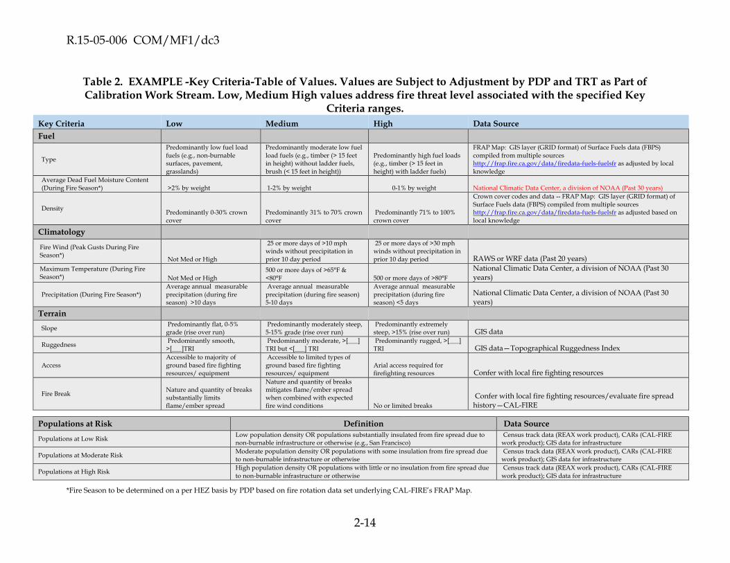
R.15-05-006 COM/MF1/dc3
2-14
Table 2. EXAMPLE -Key Criteria-Table of Values. Values are Subject to Adjustment by PDP and TRT as Part of Calibration Work Stream. Low, Medium High values address fire threat level associated with the specified Key
Criteria ranges.
Key Criteria Low Medium High Data Source
Fuel
Type
Predominantly low fuel load fuels (e.g., non-burnable surfaces, pavement, grasslands)
Predominantly moderate low fuel load fuels (e.g., timber (> 15 feet in height) without ladder fuels, brush (< 15 feet in height))
Predominantly high fuel loads (e.g., timber (> 15 feet in height) with ladder fuels)
FRAP Map: GIS layer (GRID format) of Surface Fuels data (FBPS) compiled from multiple sources http://frap.fire.ca.gov/data/firedata-fuels-fuelsfr as adjusted by local knowledge
Average Dead Fuel Moisture Content (During Fire Season*) >2% by weight 1-2% by weight 0-1% by weight National Climatic Data Center, a division of NOAA (Past 30 years)
Density Predominantly 0-30% crown cover
Predominantly 31% to 70% crown cover
Predominantly 71% to 100% crown cover
Crown cover codes and data -- FRAP Map: GIS layer (GRID format) of Surface Fuels data (FBPS) compiled from multiple sources http://frap.fire.ca.gov/data/firedata-fuels-fuelsfr as adjusted based on local knowledge
Climatology
Fire Wind (Peak Gusts During Fire Season*)
Not Med or High
25 or more days of >10 mph winds without precipitation in prior 10 day period
25 or more days of >30 mph winds without precipitation in prior 10 day period RAWS or WRF data (Past 20 years)
Maximum Temperature (During Fire Season*) Not Med or High
500 or more days of >65°F & <80°F 500 or more days of >80°F
National Climatic Data Center, a division of NOAA (Past 30 years)
Precipitation (During Fire Season*)
Average annual measurable
precipitation (during fire season) >10 days
Average annual measurable
precipitation (during fire season) 5-10 days
Average annual measurable
precipitation (during fire season) <5 days
National Climatic Data Center, a division of NOAA (Past 30 years)
Terrain
Slope Predominantly flat, 0-5% grade (rise over run)
Predominantly moderately steep, 5-15% grade (rise over run)
Predominantly extremely steep, >15% (rise over run) GIS data
Ruggedness Predominantly smooth, >[___]TRI
Predominantly moderate, >[___] TRI but <[___] TRI
Predominantly rugged, >[___] TRI GIS data—Topographical Ruggedness Index
Access Accessible to majority of ground based fire fighting resources/ equipment
Accessible to limited types of ground based fire fighting resources/ equipment
Arial access required for firefighting resources Confer with local fire fighting resources
Fire Break Nature and quantity of breaks substantially limits flame/ember spread
Nature and quantity of breaks mitigates flame/ember spread when combined with expected fire wind conditions No or limited breaks
Confer with local fire fighting resources/evaluate fire spread history—CAL-FIRE
Populations at Risk Definition Data Source
Populations at Low Risk Low population density OR populations substantially insulated from fire spread due to non-burnable infrastructure or otherwise (e.g., San Francisco)
Census track data (REAX work product), CARs (CAL-FIRE work product); GIS data for infrastructure
Populations at Moderate Risk Moderate population density OR populations with some insulation from fire spread due to non-burnable infrastructure or otherwise
Census track data (REAX work product), CARs (CAL-FIRE work product); GIS data for infrastructure
Populations at High Risk High population density OR populations with little or no insulation from fire spread due to non-burnable infrastructure or otherwise
Census track data (REAX work product), CARs (CAL-FIRE work product); GIS data for infrastructure
*Fire Season to be determined on a per HEZ basis by PDP based on fire rotation data set underlying CAL-FIRE’s FRAP Map.

R.15-05-006 COM/MP6/dc3
2-15
Table 3. Worksheet for Assigning Key Criteria Values to Each HEZ [NAME OF SERVICE TERRITORY/OTHER GEOGRAPHIC AREAS COVERED]
[INSTRUCTIONS: Include both the assigned key criteria values (e.g., Low, Med and High) as well applicable descriptions and comments/considerations]
HEZ 1 [Name]
HEZ 2 [Name]
HEZ 3 [Name]
HEZ 4 [Name]
FRAP Fire Threat Value(s)
FM 1 Index Range of Values
Fire History (From 1950-present)
Fuel
Type
Average Live Fuel Moisture Content (During Fire Season*)
Density
Climatology
Fire Wind (Peak Gusts During Fire Season)
Maximum Temperature (During Fire Season)
Precipitation (During Fire Season)
Terrain
Slope
Ruggedness
Access
Fire Break
Populations (Check One)
Populations at Low Risk
Populations at Moderate Low Risk
Populations at High Risk

R.15-05-006 COM/MP6/dc3
3-1
ATTACHMENT 3
SHAPE ‘C’ DEVELOPMENT
Shape C is the final mapping product. Shape C will further refine Shape B, taking into account the location of utility facilities and other operational concerns. It is anticipated that following the approval of Shape B, the development and review of Shape C will take approximately 8-11 weeks.
1.0 Process
This step assumes a robust and complete Shape A to B process has delivered a Shape B that will be used to create Shape C. Shape B will have been subjected to stakeholder refinement and scrutiny and approved by the Commission. Shape B will be delivered to Territory Leads for final refinement. Territory Leads (in coordination with the Communication Infrastructure Providers (CIPS) will work with the Peer Development Panel (PDP) to refine Shape B into a final map product. During this process, Shape B will be overlaid with utility overhead infrastructure.
It is anticipated that minimal changes will be made to Shape C to account for overhead infrastructure location and system operational concerns. The Territory Leads will discuss refinements with and reach agreement with CIPs in their respective territories. The PDP will deliver the final Shape C with justification for any wholesale changes to the Technical Review Team (TRT) for review and approval. It is anticipated that the TRT review and approval of Shape C will take approximately 2 weeks.
2.0 Criteria
The goal is to group overhead electric infrastructure in a logical manner to account for facility locations and operational concerns. Two types of changes can be made—those that move facilities into higher risk tiers, and those that move facilities into lower risk tiers. Changes between Shape B and Shape C are expected to be minimal and not negatively impact public safety. Changes will be visible to and reviewed by the statewide PDP.
In conjunction with the TRT, the statewide PDP will develop more explicit criteria, the required justification (i.e., Tier 3 to Tier 2) and review feedback process for the Shape B to C refinement performed the Territory Leads.

R.15-05-006 COM/MF1/dc3
3-2
3.0 FINAL REVIEW
The proposed Shape C will be reviewed by the TRT to ensure an unbiased view of the changes between Shape B and Shape C. See Fire Map 2 Workplan Summary for details of TRT review and Commission approval.

R.15-05-006 COM/MP6/dc3
4-1
ATTACHMENT 4 Event / Task Timeline
EVENT / TASK SUMMARY
Estimated w/
Consensus
Estimated w/o
Consensus
i.
REAX and SDG&E create Draft Shape A and submit to CAL FIRE or CPUC designee. (This task performed concurrently with Technical Review Team (TRT) and Peer Development Panel (PDP) formation.)
October 2016
(2 weeks)
ii.
1. CAL-FIRE or CPUC designee review Draft Shape A with REAX and SDG&E.
2. REAX-SDG&E revise Draft Shape A, as-necessary.
3. Tier 1 Advice Letter filed; OR CAL FIRE or Commission Designee consults with Assigned Commissioner or ALJ to resolve impasse.
November 2016
(2 weeks)
iii.
PDP formed and Territory Leads identified (This task performed concurrently with TRT formation and Shape A creation.)
Oct. - Nov. 2016
(2 weeks)
iv.
PDP develops work/review process and decision making criteria (May include Territory Leads.)
Nov. – Dec. 2016
(4 - 5 weeks)
v.
1. TRT formed. 2. Contract negotiations initiated. 3. Contracts finalized with TRT members
following CPUC Decision. (This task performed concurrently with PDP formation and Shape A creation.)
Nov. – Dec. 2016
vi. CPUC issues Decision approving FM 2 work plan
December 2016
(Day “0”)
vii. CPUC approves Shape A Day 0
Day 28 - 35 (4-7 weeks)
viii.
Shape A refined by Territory Leads and PDP to create Draft Shape B (w/tiers). (Consultation w/TRT regularly to affirm refinement processes and protocols are followed.)
Day 112 – 168 (16-24
weeks)
Day 140 – 203 (16-24
weeks)

R.15-05-006 COM/MP6/dc3
4-2
EVENT / TASK SUMMARY
Estimated w/
Consensus
Estimated w/o
Consensus
ix.
1. PDP prepares Draft Shape B for public comment.
2. Public Comment period on Draft Shape B is completed.
3. TRT and PDP address comments and refine Draft Shape B as-necessary.
4. Tier 1 Advice Letter filed, OR Report filed with CPUC identifying impasse areas (all).
Day 140 - 196
(4 Weeks)
Day 168 - 259
(4-8 Weeks)
x.
Comment on and CPUC approval of Shape B (Assumes no Evidentiary Hearings.)
Day 140 - 217
(0-3 weeks)
Day 224 – 343
(8-12 weeks)
xi. Territory Leads in coordination with CIPs refine Shape B and create Draft Shape C
Day 182 – 273
(6-8 weeks)
Day 266 – 399
(6-8 weeks)
xii.
1. TRT reviews Draft Shape C 2. PDP refines Draft Shape C (as-needed) 3. Tier 1 Advice Letter filed; OR Report filed with
CPUC identifying impasse areas.
Day 196 – 294
(2-3 weeks)
Day 280 – 420
(2-3 weeks)
xiii.
Comment on and CPUC approval of Shape C (Assumes no Evidentiary Hearings.)
Day 196 - 315 days
(0-3 weeks)
Day 336 – 504
(8-12 weeks)
xiv. CPUC disseminates Fire Map 2 Day 203 -
322 (1 week)
Day 343 - 511
(1 week)

R.15-05-006 COM/MP6/dc3
5-1
ATTACHMENT 5
Scoping Memo Appendix B Cross-Reference Chart
Appendix B Section Appendix B Topic
Section where App B Topic is Addressed in Workshop
Report
1. The Fire Map 2 Work Plan prepared jointly by the parties shall include a detailed work plan for the development, adoption, and implementation of a Fire Map 2 that:
1.i Incorporates Fire Map 1. I.A; Attachment 1
1.ii Covers the entire state. III.B; Attachment 2
1.iii Identifies the types and locations of overhead power-line facilities in the high fire-threat areas.
III.C; IV.A; Attachment 3
1.iv Identifies the types and locations of aerial telecommunications facilities in close proximity to overhead power-line facilities in the high fire-threat areas.
III.C; IV.A; Attachment 3
1.v Integrates with the fire-prevention measures adopted in R.08-11-005 and this proceeding (R.15-05-006) that rely on fire-threat maps for their implementation.
Attachment 1
1.vi Will be available to Commission staff, fire-safety agencies, and the public, while also protecting information about critical infrastructure or which may be proprietary.
II; III; IV.A
2. The Fire Map 2 Work Plan shall include the following:
2.i The types of information, the level of detail, and other characteristics that Fire Map 2 must possess.
I.A; III; Attachments 1-3
2.ii A detailed work plan for the funding (if needed), development, expert review (if needed), adoption, and implementation of Fire Map 2
III; IV.B
2.iii The specific technical expertise from neutral third parties such as CAL-FIRE that is needed, if any, to develop and/or review Fire Map 2, and an explanation of how this expertise can be obtained. Recommendations for obtaining assistance from CAL-FIRE should take into account that CAL-FIRE’s ability to provide assistance is limited. (PHC Transcript at 58 – 63.)
II; IV.B
2.iv If the Fire Map 2 Work Plan anticipates contracting with neutral experts, the work plan shall (a) identify who will select the neutral experts; (b) explain how the contracting process will work; and (c) identify who will oversee the work performed by the neutral experts.
IV.B
2.v The estimated cost to carry out Item 2.ii above, including the cost of contracting with neutral experts, if necessary.
IV.B
2.vi A recommended funding mechanism, if needed, for the IV.B

R.15-05-006 COM/MP6/dc3
5-2
Appendix B Section Appendix B Topic
Section where App B Topic is Addressed in Workshop
Report
development, expert review (if needed), and implementation of Fire Map 2. One option is to provide utility funding and cost recovery using the Fire Hazard Prevention Memorandum Accounts that are described in D.12-01-032 at pages 153 – 156.
2.vii A proposed schedule, recommended procedures (e.g., workshops), and milestones for the actual development, expert review (if needed), adoption, and implementation of Fire Map 2, including conforming revisions to GO 95 and GO 165.
Attachment 4
2.viii A discussion of whether electric utilities and communication infrastructure providers (CIPs) should be able to adjust the boundaries of Fire Map 2 based on their own expertise and local conditions and, if so, whether and how such adjustments should be vetted and incorporated into the approved Fire Map 2.
III.B; Attachment 2
2.ix A description of how the adopted Fire Map 2 should be updated, the frequency of such updates, and the procedure by which the updated Fire Map 2 will be incorporated into GO 95 and other GOs, if applicable.
IV.C
2.x A statement of whether the adoption of Fire Map 2 is subject to the California Environmental Quality Act (CEQA) and, if so, when and how the CEQA review would occur.
IV.C
2.xi Alternative recommendations if the parties cannot reach a consensus on all issues. The alternatives should provide the same level of detail as the Fire Map 2 Work Plan. It will be the responsibility of any party proposing an alternative to prepare the alternative that is included in the Fire Map 2 Work Plan.
See III.B (alternative re number of tiers) II (backup plan for TRT leadership).
Additionally parties have been invited to comment on several other issues where there was a change since the workshops (e.g. III.B , public input in light of SB 1463 veto) or which were not thoroughly discussed (e.g. IV.C, tree mortality layer, updates to Map 2, transitioning regulations)
2.xii A list of Commission actions that may be required to implement the Fire Map 2 Work Plan and alternatives, such as rulings and/or Commission decisions approving the (a) work plan, (b) any associated funding mechanism, and/or (c) the final Fire Map 2.
III.A-C; Attachments 2-3
3. The Fire Map 2 Work Plan shall address:
3.i Validation of Fire Map 2 against historical fires. IV.C

R.15-05-006 COM/MP6/dc3
5-3
Appendix B Section Appendix B Topic
Section where App B Topic is Addressed in Workshop
Report
3.ii Incorporating into Fire Map 2 additional factors and conditions that affect fire hazards associated with overhead utility facilities generally and at specific locations (e.g., Laguna Beach). Such factors and conditions may include the parties’ knowledge of (A) terrain; (B) vegetation (e.g., potential contact between trees and power lines in low-wind areas); (C) areas designated as high hazard zones pursuant to the Governor’s Proclamation of a State of Emergency issued on October 30, 2015; (D) microclimates; (E) historical power-line fires besides the October 2007 fires in Southern California (e.g., the September 2015 Butte Fire in Amador and Calaveras Counties); (F) other historical fires; and (G) other factors and conditions.
IV.C; Attachment 2
3.iii Incorporating into Fire Map 2 the fire hazards associated with historical power-line fires besides the October 2007 fires in Southern California. These other power-line fires include the Butte Fire that burned 71,000 acres in Amador and Calaveras Counties in September 2015.2
IV.C; Attachment 2
3.iv Whether historical fires and other factors demonstrate that the City of Laguna Beach should be designated as a high fire-hazard area on Fire Map 2.3
IV.C
3.v Incorporating into Fire Map 2 the utilities’ knowledge of local conditions in setting the boundaries of the High Fire-Threat District.
III.B; Attachment 2
3.vi Incorporating into Fire Map 2 the consequences (i.e., risks) of power-line wildfires.
IV.C
3.vii Transitioning existing regulations that rely on interim fire-threat maps to Fire Map 2.
IV.C
4. The Fire Map 2 Work Plan shall address the proposal for a statewide Fire Map 2 contained in Appendix C of this Scoping Memo and Ruling.
III
5. Any other matters the parties deem appropriate, provided that such matters are within the scope of the Fire Map 2 Work Plan. Such matters may include those listed in Item 2 of the ruling dated June 2, 2016, at pages 4 – 5, but parties should be careful about slowing and/or overloading the development of Fire Map 2 with additional topics.
6. When possible, the Fire Map 2 Work Plan and any alternatives to the Work Plan should enable the rapid development and adoption of Fire Map 2.
Attachment 4

R.15-05-006 COM/MP6/dc3
6-1
ATTACHMENT 6
Fire Map 2 Development Plan Workshop Protocols
Omitted.
Attachment 6 was provided with the
Workshop Report that was filed and served.

R.15-05-006 COM/MP6/dc3
7- 1
ATTACHMENT 7
FSTP Workshop Agendas – Recaps / Notes – Attendee Lists
Omitted.
Attachment 7 was provided with the
Workshop Report that was filed and served.