Embed Size (px)
Citation preview

Decision Support Briefing
Tuesday, December 11, 2018
NWSSERFC @NWSSERFC
Issued:
Weather Ready Nation
NWSSERFC @NWSSERFC12/11/2018 10:02 AM
• Widespread minor river flooding, with some isolated
moderate flooding, is occurring or forecast as a result of the
latest precipitation event across the southeast US.
• The potential for a “rain-on-snow” flood event in North
Carolina and Virginia is becoming more likely as the next
precipitation event approaches.

NWSSERFC @NWSSERFC
Over the past 24 hours, precipitation was generally light
across the northern half of the SERFC service area.
Heaviest precipitation totals were found across portions
of the coastal plain of North Carolina.
Over the next 48 hours, no significant precipitation is
expected across the SERFC area of responsibility.

NWSSERFC @NWSSERFC
In areas that received liquid precipitation,
headwater forecast points have generally
crested over the past couple of days and
flood waves are working their way
downstream on rivers across the
Southeast.
Using 48 hours of forecast rainfall, this
map depicts current and forecast flood
conditions.
Please visit the SERFC home page or your
local weather office’s page for more
details and updates to the forecasts.
https://www.weather.gov/serfc/
NWSSERFC @NWSSERFC
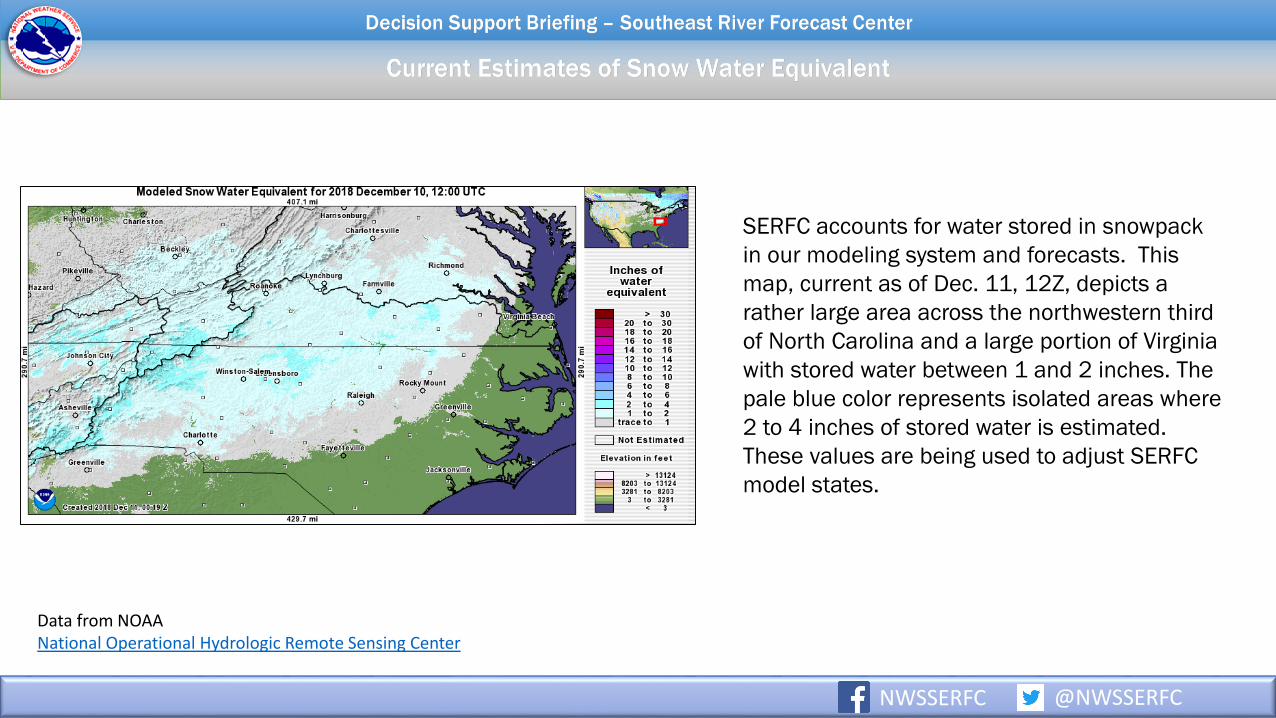
SERFC accounts for water stored in snowpack
in our modeling system and forecasts. This
map, current as of Dec. 11, 12Z, depicts a
rather large area across the northwestern third
of North Carolina and a large portion of Virginia
with stored water between 1 and 2 inches. The
pale blue color represents isolated areas where
2 to 4 inches of stored water is estimated.
These values are being used to adjust SERFC
model states.
Data from NOAANational Operational Hydrologic Remote Sensing Center
NWSSERFC @NWSSERFC
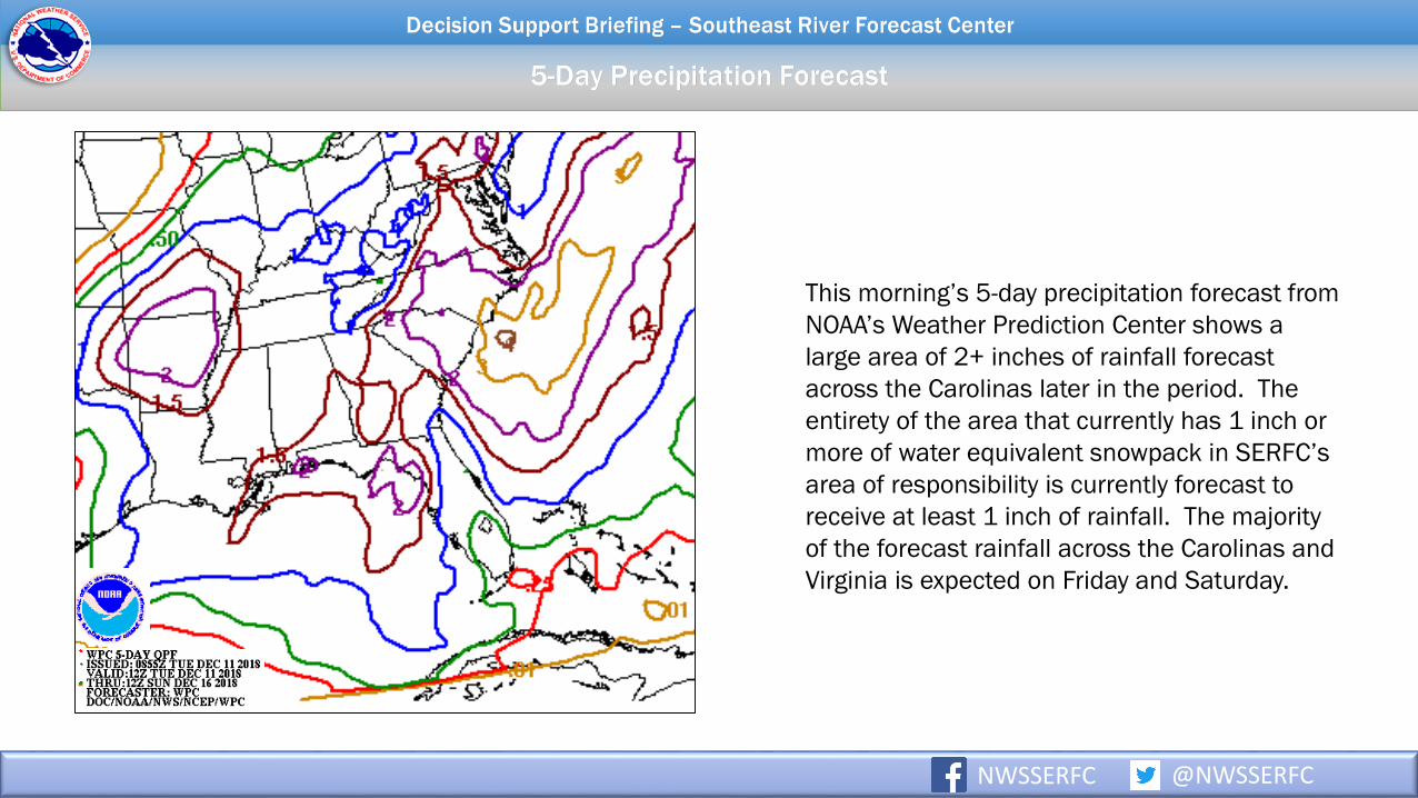
This morning’s 5-day precipitation forecast from
NOAA’s Weather Prediction Center shows a
large area of 2+ inches of rainfall forecast
across the Carolinas later in the period. The
entirety of the area that currently has 1 inch or
more of water equivalent snowpack in SERFC’s
area of responsibility is currently forecast to
receive at least 1 inch of rainfall. The majority
of the forecast rainfall across the Carolinas and
Virginia is expected on Friday and Saturday.

NWSSERFC @NWSSERFC
The state of the snowpack and the distribution of forecast rainfall
through this next potential flood event will continue to be
reassessed as additional observations and model information
are received.
One way to depict the potential scenarios is through ensemble
modeling. These simulations are produced by varying forecast
precipitation and temperature scenarios through the next week.
This morning’s ensemble run, using the GEFS, indicates a range
of hydrographs with an enhanced flood threat depicted across
Virginia and North Carolina starting Friday, Dec. 14.
These runs are automated and do not replace official forecasts.
Updates and station-specific plots of precipitation, temperature,
snowpack, and streamflow can be found on the MMEFS website.

• SERFC will terminate 24 hours operations this evening.
• The Decision Support Briefing will continue until further notice.
Please send all operational correspondence [email protected] or call the office directly.
NWSSERFC @NWSSERFCWeather Ready Nation

Latest Radar SERFC Quick Brief
Latest Forecast
RainfallMMEFS – Ensemble River Forecasts
NWSSERFC @NWSSERFCWeather Ready Nation

• These slides are intended for your use. Please feel free to share these with others. If you have anyquestions please email [email protected] or contact your local NWS Weather Forecast Office.
• Remember: SERFC briefings cover freshwater flooding. For information on coastal and tidal flooding,flash floods, winds, and severe weather risks, please contact your local Weather Forecast Office.
NWSSERFC @NWSSERFCWeather Ready Nation


![Weekly Report Drought Monitor / Snowpack Update€¦ · Weekly Report - Snowpack / Drought Monitor Update Date: 29 December 2011 [End of Year Edition] SNOTEL SNOWPACK AND PRECIPITATION](https://img.pdfslide.net/doc/110x75/5f14161a6565b54157769b36/weekly-report-drought-monitor-snowpack-update-weekly-report-snowpack-drought.jpg)