Embed Size (px)
Citation preview

1 de 27
Received: 23 Apr. 2021 - Approved: 29 Sept. 2021 Evaluation Process: Double Blind Review https://doi.org/10.5585/geas.v10i1.19876 e-ISSN: 2316-9834
_____________________________________________________________ Rev. Gest. Amb. e Sust. – GeAS
J. Environ. Manag. & Sust.
10(1), p. 1-27, e19876, 2021
JOURNAL OF ENVIRONMENTAL MANAGEMENT & SUSTAINABILITY
REVISTA DE GESTÃO AMBIENTAL E SUSTENTABILIDADE – GeAS
Decision support system applied to water resources management: PCJ Basins case study
Mayara Sakamoto Lopes1 João Rafael Bergamaschi Tercini2 Aline Doria de Santi3
Diogo Bernardo Pedrozo4 Joaquin Ignacio Bonnecarrère Garcia5 Victor Alberto
Romero Gonzalez6 Eduardo Cuoco Léo7
1 Master’s degree in Civil and Environmental Engineering, Hydraulics Technological Center Foundation - FCTH. Piracicaba São
Paulo Brazil. [email protected] 2 Master’s degree in Water Resources Engineering, Hydraulics Technological Center Foundation - FCTH. São Paulo São Paulo Brazil. [email protected] 3 Master of Science in Environmental Engineering, Hydraulics Technological Center Foundation - FCTH. Piracicaba São Paulo Brazil. [email protected] 4 MBA’s degree in Project Management, Hydraulics Technological Center Foundation - FCTH. Piracicaba São Paulo Brazil.
[email protected] 5 PhD’s degree in Hydraulic Engineering, University of São Paulo – USP. São Paulo São Paulo Brazil. [email protected] 6 Degree in Systems Engineering and Electronic Engineering, Hydraulics Technological Center Foundation - FCTH. São Paulo
São Paulo Brazil. [email protected] 7 Master’s degree in Applied Ecology, Agency for the Piracicaba, Capivari and Jundiaí Rivers – PCJ Basin Agency. Piracicaba São Paulo Brazil. [email protected]
Cite as American Psychological Association (APA) Lopes, M. S., Tercini, J. R. B., Santi, A. D., Pedrozo, D. B., Bonnecarrère, J. I. G., Gonzalez, V. A. R., & Léo, E.
C. (2021). Decision support system applied to water resources management: PCJ Basins case study. Rev. Gest. Ambient. e Sust. - GeAS., 10(1), 1-27, e19876. https://doi.org/10.5585/geas.v10i1.19876.
Abstract Objective: Presenting the particularities of the PCJ Basin Decision Support System (SSD PCJ), highlighting its contributions to the management and planning of water resources. Methodology: Case study based on the application of the SSD PCJ to the management actions of the PCJ Basins. Relevance: Technological advancement implied an increase in data on water resources, requiring more time and effort to be manipulated and analyzed. Thus, investments in databases and systems that transform data into useful information are necessary, so that they can be easily accessed by users in their water resources management and planning processes. Thus, the experiences of the application of the SSD PCJ to the management of the PCJ Basins were discussed and can be replicated in other hydrographic regions. Results: The discussions indicate that the SSD PCJ has characteristics that enhance its application to the management and planning of water resources, with public disclosure of both historical and real time data, allowing users to compare different periods and monitoring points, as well as integrated quality and quantity analyses. Contributions: The application of the SSD PCJ has been shown to be effective in monitoring the occurrence of rain and the water bodies situation, enabling in real time the identification of risk situations and the issuance of alerts to minimize adverse impacts, besides assessing compliance with regulatory standards, feeding simulation models, and supporting analyses of water availability and quality. Keywords: Decision support system. Information system. Water resources planning. Water resources management. PCJ Basins.
Sistema de suporte a decisões aplicado ao gerenciamento de recursos hídricos:
estudo de caso Bacias PCJ
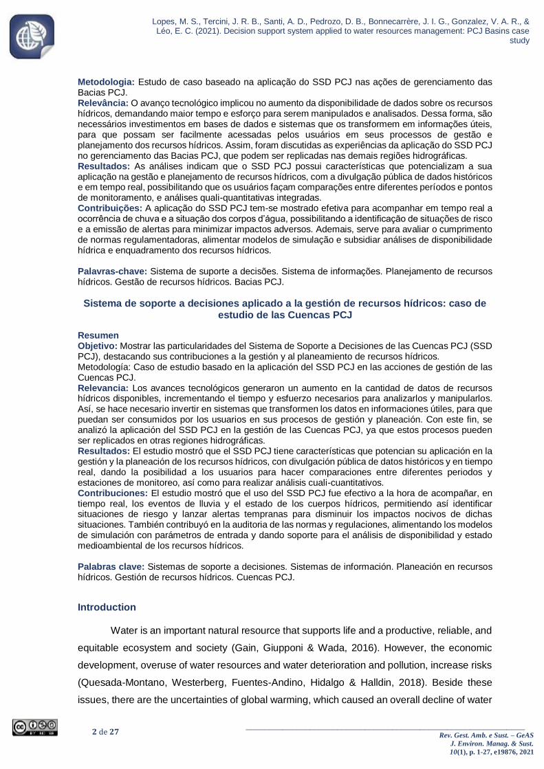
Resumo Objetivo: Apresentar as particularidades do Sistema de Suporte a Decisões das Bacias PCJ (SSD PCJ), destacando suas contribuições à gestão e ao planejamento de recursos hídricos.
2 de 27 _____________________________________________________________
Rev. Gest. Amb. e Sust. – GeAS
J. Environ. Manag. & Sust.
10(1), p. 1-27, e19876, 2021
Lopes, M. S., Tercini, J. R. B., Santi, A. D., Pedrozo, D. B., Bonnecarrère, J. I. G., Gonzalez, V. A. R., & Léo, E. C. (2021). Decision support system applied to water resources management: PCJ Basins case
study
Metodologia: Estudo de caso baseado na aplicação do SSD PCJ nas ações de gerenciamento das Bacias PCJ. Relevância: O avanço tecnológico implicou no aumento da disponibilidade de dados sobre os recursos hídricos, demandando maior tempo e esforço para serem manipulados e analisados. Dessa forma, são necessários investimentos em bases de dados e sistemas que os transformem em informações úteis, para que possam ser facilmente acessadas pelos usuários em seus processos de gestão e planejamento dos recursos hídricos. Assim, foram discutidas as experiências da aplicação do SSD PCJ no gerenciamento das Bacias PCJ, que podem ser replicadas nas demais regiões hidrográficas. Resultados: As análises indicam que o SSD PCJ possui características que potencializam a sua aplicação na gestão e planejamento de recursos hídricos, com a divulgação pública de dados históricos e em tempo real, possibilitando que os usuários façam comparações entre diferentes períodos e pontos de monitoramento, e análises quali-quantitativas integradas. Contribuições: A aplicação do SSD PCJ tem-se mostrado efetiva para acompanhar em tempo real a ocorrência de chuva e a situação dos corpos d’água, possibilitando a identificação de situações de risco e a emissão de alertas para minimizar impactos adversos. Ademais, serve para avaliar o cumprimento de normas regulamentadoras, alimentar modelos de simulação e subsidiar análises de disponibilidade hídrica e enquadramento dos recursos hídricos. Palavras-chave: Sistema de suporte a decisões. Sistema de informações. Planejamento de recursos hídricos. Gestão de recursos hídricos. Bacias PCJ.
Sistema de soporte a decisiones aplicado a la gestión de recursos hídricos: caso de estudio de las Cuencas PCJ
Resumen Objetivo: Mostrar las particularidades del Sistema de Soporte a Decisiones de las Cuencas PCJ (SSD PCJ), destacando sus contribuciones a la gestión y al planeamiento de recursos hídricos. Metodología: Caso de estudio basado en la aplicación del SSD PCJ en las acciones de gestión de las Cuencas PCJ. Relevancia: Los avances tecnológicos generaron un aumento en la cantidad de datos de recursos hídricos disponibles, incrementando el tiempo y esfuerzo necesarios para analizarlos y manipularlos. Así, se hace necesario invertir en sistemas que transformen los datos en informaciones útiles, para que puedan ser consumidos por los usuarios en sus procesos de gestión y planeación. Con este fin, se analizó la aplicación del SSD PCJ en la gestión de las Cuencas PCJ, ya que estos procesos pueden ser replicados en otras regiones hidrográficas. Resultados: El estudio mostró que el SSD PCJ tiene características que potencian su aplicación en la gestión y la planeación de los recursos hídricos, con divulgación pública de datos históricos y en tiempo real, dando la posibilidad a los usuarios para hacer comparaciones entre diferentes periodos y estaciones de monitoreo, así como para realizar análisis cuali-cuantitativos. Contribuciones: El estudio mostró que el uso del SSD PCJ fue efectivo a la hora de acompañar, en tiempo real, los eventos de lluvia y el estado de los cuerpos hídricos, permitiendo así identificar situaciones de riesgo y lanzar alertas tempranas para disminuir los impactos nocivos de dichas situaciones. También contribuyó en la auditoria de las normas y regulaciones, alimentando los modelos de simulación con parámetros de entrada y dando soporte para el análisis de disponibilidad y estado medioambiental de los recursos hídricos. Palabras clave: Sistemas de soporte a decisiones. Sistemas de información. Planeación en recursos hídricos. Gestión de recursos hídricos. Cuencas PCJ.
Introduction
Water is an important natural resource that supports life and a productive, reliable, and
equitable ecosystem and society (Gain, Giupponi & Wada, 2016). However, the economic
development, overuse of water resources and water deterioration and pollution, increase risks
(Quesada-Montano, Westerberg, Fuentes-Andino, Hidalgo & Halldin, 2018). Beside these
issues, there are the uncertainties of global warming, which caused an overall decline of water

3 de 27 _____________________________________________________________
Rev. Gest. Amb. e Sust. – GeAS
J. Environ. Manag. & Sust.
10(1), p. 1-27, e19876, 2021
Lopes, M. S., Tercini, J. R. B., Santi, A. D., Pedrozo, D. B., Bonnecarrère, J. I. G., Gonzalez, V. A. R., & Léo, E. C. (2021). Decision support system applied to water resources management: PCJ Basins case study
availability in all continents in the last century (Sordo-Ward, Granados, Martín-Carrasco &
Garrote, 2016).
In a global context, Brazil has a large water supply. However, regional reviews
evidence that the relations between supply and demand are not uniform, mainly in metropolitan
regions, such as São Paulo (MRSP) and Campinas (MRC), with around 21.5 and 3.2 million
inhabitants, respectively. Both metropolitan regions are in water basins whose contributing
areas have less availability than the necessary to supply the population demand, which can
generate water supply instability (Braga & Kelman, 2016). Therefore, the existence of regions
that have a high pressure on water resources – considering qualitative and quantitative
aspects – shows an urgency to evaluate and to predict the water resources trends and
evolutions. Also urgent is formulating public policies to deal with severe water crisis.
Water resources management thus requires actions of different types, including
political and legislative governance, management, technological innovation, and behavior
change (Gössling, 2015). Therefore, the water management process includes technical,
political, legislative, and organizational aspects (Costanza et al., 2017). The technical aspects
include management of water supply and demand (Ghasemi, Saghafian & Golian, 2017;
Ghashghaie, Marofi & Marofi, 2014), water allocation (Karamouz, Kerachian & Zahraie, 2004),
goals of water safety policies (Bolognesi & Kluser, 2018; Dadson et al., 2017) and decision
support (Pallotino, Sechi & Zuddas, 2005).
Water resources monitoring is therefore important to provide data about water basins
situation, considering aspects related to water availability and quality. Monitoring this
information enables to detect space-time possible changes in the water bodies parameters.
Water resources monitoring also helps diagnose and evaluate aquatic ecosystems and
support decisions about water management.
Although water resources monitoring has several purposes, its main goals are: i)
monitoring the water quality and availability changes; ii) analyzing variable trends and
elaborating behavioral predictions; iii) warning about unexpected adverse impacts or trends
changes previously observed; iv) detecting quality standards violation or operating rules
prescribed by law; v) providing immediate information when an indicator shows critical values;
vi) recording impacts resulting from such an action; vii) evaluating the effectiveness of actions
held in a basin; viii) providing information enabling an assessment of correctives measures; iv)
developing management tools; and x) providing resources for decision-making (Longo Júnior,
2011; Agência Nacional de Águas e Saneamento Básico [ANA], n.d.).
Considering that continuous monitoring generates a huge amount of data about the
water basin, it is evident that water resources management requires a systematically organized
database and computational tools that enable quick access to updated information (Santi,
Lopes, Pedrozo, Léo & Barufaldi, 2020; Porto & Porto, 2008).
4 de 27 _____________________________________________________________
Rev. Gest. Amb. e Sust. – GeAS
J. Environ. Manag. & Sust.
10(1), p. 1-27, e19876, 2021
Lopes, M. S., Tercini, J. R. B., Santi, A. D., Pedrozo, D. B., Bonnecarrère, J. I. G., Gonzalez, V. A. R., & Léo, E. C. (2021). Decision support system applied to water resources management: PCJ Basins case
study
Therefore, the first step to implement water policies is providing data and information
access about current and historical situation of water bodies and their uses (IOWater, 2013).
Thus, the Water Resources Information Systems (WRIS) stand out as important management
tools and must follow three basic principles: decentralization of achievement and production
of data and information; unified system coordination; and guarantee of data and information
access for society (Lei nº 9433, 1997).
Overall, these systems aim to gather, consist and disseminate data and information
about water resources quality and availability; permanently update information about water
availability and demand; provide resources to produce Water Resources Plans (Lei nº
9.433,1997). In addition, the systems intend to collect, select, and process the data to support
decision-making; optimize and qualify decision-making; regularly provide information for all
management levels; and democratize access to information (ANA, 2016, p. 28).
This shows that the WRIS are the heart of water resources management because the
main goal of the process is making effective decisions to ensure the required availability and
quality for water uses. Therefore, Porto and Porto (2008) highlighted that decision-making
cannot occur without structured and updated database, being essential to invest in Decision
Support System (DSS), responsible for elevating the qualification of decision-making
processes.
Due to the relevant contributions of DSSs to the water resources management process,
the PCJ Basins Decision Support System (SSD PCJ, an acronym in Portuguese) was
developed in Piracicaba, Capivari and Jundiaí Water Basins (PCJ Basins) – case study in this
paper – to support the complex decision-making process in the region. In this overview,
focusing on sharing experiences, this paper presents the SSD PCJ features, highlighting the
contribution to support the water resources management and planning in the PCJ Basins.
The role of DSSs in water resources management
DSSs are a knowledge resource that can facilitate decision making or achieve specific
goals, integrating information about water and intervening factors into management (Moran,
Saracino, Sugg, Thompson & Martinez, 2020). With more integrated approaches, they help to
define sustainable policies (considering environmental, social and economic factors) and
provide greater input to support both water resource planning (e.g., investments) and real time
system operations (e.g. flood management) (Lima, 2007; INBO & UNESCO, 2018).
The content of these systems is complex, covering several aspects, which depend
above all on their main objective; in the case of water systems, it involves total water resources
and water consumption (Bagstad, Semmens, Waage & Winthrop, 2013; Moran et al., 2020;
Walker, Beck, Hall, Dawson & Heidrich, 2014). Although Denzer (2005) corroborates the

5 de 27 _____________________________________________________________
Rev. Gest. Amb. e Sust. – GeAS
J. Environ. Manag. & Sust.
10(1), p. 1-27, e19876, 2021
Lopes, M. S., Tercini, J. R. B., Santi, A. D., Pedrozo, D. B., Bonnecarrère, J. I. G., Gonzalez, V. A. R., & Léo, E. C. (2021). Decision support system applied to water resources management: PCJ Basins case study
complexity of DSS, the author cites characteristics inherent to these systems: i) complex data
in time and space, often incomplete and out of scale for the intended use; ii) complex
algorithms resulting in tools linked to databases, real time monitoring systems, Geographic
Information Systems (GIS), etc.; iii) problems with data control, caused by the diversity of
formats and difficulties in integrating methodologies; and iv) need to unify different tools and
methodologies into a single solution for the end user. In addition, Lima (2007) highlights that
the systems must be made available in an online interface, with their input data and results, to
provide transparency to the user.
Regarding the DSS structure, they generally consist of three interrelated modules:
database, mathematical models and dialog interface. The database is responsible for storing
data and information; the model base is composed of the mathematical models to be used in
simulations and in the transformation of data into information; and the dialog module enables
user-system interaction.
Russell, Vaughan, Clark, Rodriguez and Darling (2001) show that the technology
involved makes it possible for DSS to be able to provide simple and powerful tools to import,
organize, manipulate, and export large amounts of data, and that GIS play an important role
by storing data spatially. The database must feed the models, allowing users to build and
analyze alternative scenarios, to provide them with the choice of the best actions to be
implemented in the river basin (Ono, 2008).
However, note that the challenge when developing an DSS is to meet the needs of
those involved at different decision-making levels. Although there are numerous particularities,
these systems must be able to: i) help users to develop their own models and identify the most
important issues to manage the hydrographic basin of interest; ii) provide an initial view of the
interrelationships between the different components of the system; and iii) facilitate
communication and understanding by all those involved, so that they share the same vision
(Loucks, 2006).
From these perspectives, the dialogue module is essential in communicating with the
user, facilitating the participation of non-specialists in decision-making processes. This is of
fundamental importance for river basin committees, as interaction takes place in this module,
enabling information to be obtained, incorporating the judgments of interested parties and
analyzing results to support decision-making processes (Braga, Barbosa & Nakayama, 1998;
Porto & Porto, 2008; INBO & UNESCO, 2018).
Study area
The PCJ Basins are inserted in the Tietê River Hydrographic Basin, encompassing 76
municipalities (totally and partially inserted), being 93% in the territory of the State of São Paulo

6 de 27 _____________________________________________________________
Rev. Gest. Amb. e Sust. – GeAS
J. Environ. Manag. & Sust.
10(1), p. 1-27, e19876, 2021
Lopes, M. S., Tercini, J. R. B., Santi, A. D., Pedrozo, D. B., Bonnecarrère, J. I. G., Gonzalez, V. A. R., & Léo, E. C. (2021). Decision support system applied to water resources management: PCJ Basins case
study
and 7% in the State of Minas Gerais. With approximately 15.300 km² of drainage area, the
planning and management of water resources in the region can take place at five levels of
detail: 39.430 otto-codified contribution areas (otto-basins); 225 contribution areas (CAs); 37
zones; 7 sub-basins and 3 main basins (Consórcio Proffil-Rhama, 2020).
With 5.85 million inhabitants (Fundação Agência das Bacias PCJ, 2020), this region is
marked by a history of low per capita water availability and high demands, especially for
supplying the MRC, which represents 54% of the total supply demand of the PCJ Basins. This
complexity is intensified in water crisis scenarios, in which decision-making must be based on
reliable data and information to manage existing conflicts and ensure that users' demand is
met. In the water crisis experienced in 2014, for example, the use of data generated by the
PCJ Basins telemetric system was essential to monitor the storage of the Cantareira System
and the situation of water bodies in the region (Lopes, et al. 2019).
The Cantareira System is highlighted in the PCJ Basins, as four of the six reservoirs
that comprise it are in the region's drainage area, and the water reserved in this system is used
to supply approximately 10 million inhabitants of the MRSP and the PCJ Basins (Fundação
Agência das Bacias PCJ, 2020). Considering that part of the water from some rivers in the
Piracicaba River basin is transferred to the Alto Tietê basin because of that system, operating
rules were established in 2017 (ANA/DAEE Resolução n. 925, 2017) aiming at meeting the
requirements of the demands of the two regions.
The importance of monitoring the situation of water bodies is hence reinforced, citing
as an example the monitoring of strategic points in the Atibaia River (in Atibaia/SP and
Valinhos/SP) and in the Jaguari River (in Morungaba/SP). In these cases, the data are used
to feed simulations and models for forecasting rainfall and flow (Consórcio Profill-Rhama,
2020; Almeida et al., 2019); to verify compliance with operating conditions and support
decisions about the discharge of flows from the Cantareira System (Resolução ANA/DAEE n.
925, 2017); to alert users, PCJ Situation Room (PCJSR) and Civil Defense about possible
risks; to assist in the operational management of users who catch water from their respective
water body; and also to support the planning of the PCJ Basins, especially when assessing
the criticality of the water balance, indicating the need for investments in structural and non-
structural measures.
In order to make the decision process more robust, it is essential to integrate monitoring
data with the DSS, which are enhanced with numerous functionalities, according to the users'
needs. Next, the experience of the SSD PCJ is presented, a tool that has contributed to
ensuring efficiency in the management of water resources in the PCJ Basins.
7 de 27 _____________________________________________________________
Rev. Gest. Amb. e Sust. – GeAS
J. Environ. Manag. & Sust.
10(1), p. 1-27, e19876, 2021
Lopes, M. S., Tercini, J. R. B., Santi, A. D., Pedrozo, D. B., Bonnecarrère, J. I. G., Gonzalez, V. A. R., & Léo, E. C. (2021). Decision support system applied to water resources management: PCJ Basins case study
PCJ Basins Decision Support System – SSD PCJ
The DSS use for water resources management in the PCJ Basins was made possible
in 2003 by an intention protocol signed between the State Secretariat of Energy, Water
Resources and Sanitation of the State of São Paulo, the Alto Tietê Basin Committee (CBH-
AT), the Piracicaba, Capivari and Jundiaí River Basin Committees (PCJ Committees), the
State of São Paulo Department of Water and Electric Energy (DAEE), the State of São Paulo
Basic Sanitation Company (Sabesp) and the Intercity Consortium of the Piracicaba, Capivari
and Jundiaí River Basins (PCJ Consortium). The initial goal of the system was to optimize the
use of public water sources.
In the second development stage, in 2007, the focus was integrating water allocation
and quality models in a friendly georeferenced basis with data input and output, which could
be exported to other software, such as text editors and spreadsheets. This tool was the basis
for generating simulated scenarios for the PCJ Basins Plan 2010-2020 (Cobrape, 2010),
enabling the assessment of the quantity and quality of surface waters.
The third stage began in 2011, with the creation of the Piracicaba, Capivari and Jundiaí
River Basins Agency Foundation (PCJ Basins Agency). In this period, the SSD PCJ started to
cover methodology and procedures for forecasting levels and flows in water bodies with a
range of six hours to ten days.
The fourth stage aimed to restructure and to improve the existing web decision support
tools, which involved a deep code refactoring and the largest development so far. Furthermore,
the databases of interest to the PCJ Basins were integrated and centralized in the system, and
their automatic updating mechanisms were developed. Due to substantial changes, efforts
were invested in training in using the system, with more than twenty training courses being
carried out.
In the fifth stage – still in progress – the goal is to expand the capacity for collecting,
analyzing, and making available information to support decisions and planning of water
resources in the region. In this stage, as innovation, a local support team at the PCJ Basins
Agency stands out, as well as keeping the routines maintenance and the continuous
improvement of the system - with all its functionalities, tools, mathematical models, and
programming languages -, always considering technologies more suited to the Foundation's
reality.
In Figure 1, the stages of development of the SSD PCJ are presented by different
functionalities. In general, the direction of the functional axis corresponds to the increase in
the complexity of both: the solution and the understanding of the problem.

8 de 27 _____________________________________________________________
Rev. Gest. Amb. e Sust. – GeAS
J. Environ. Manag. & Sust.
10(1), p. 1-27, e19876, 2021
Lopes, M. S., Tercini, J. R. B., Santi, A. D., Pedrozo, D. B., Bonnecarrère, J. I. G., Gonzalez, V. A. R., & Léo, E. C. (2021). Decision support system applied to water resources management: PCJ Basins case
study
Figure 1
SSD PCJ development timeline
Source: The authors (2021).
Figure 1 shows that the development started with a data-oriented DSS for water
resources, to solve the problems of access to information by the water resources system
stakeholders. That was followed by a model-oriented DSS that could generate planning
alternatives and support decisions related to the PCJ Basins Plan 2010-2020. Later, flood
events in the PCJ Basins, in 2009-2010, resulted in the prioritization of a data-driven DSS and
real time forecasting models, supporting decision-making in the face of flood occurrences.
The creation of the PCJ Basins Agency, in 2009, played an important role in the
development process of the SSD PCJ, as the actions related to decision support began to be
coordinated. There was thus the fusion of learning and functionalities of previous projects, and
the inclusion of participatory modeling, which aims to make decisions based on
methodologically standardized results accepted by all stakeholders (Basco-Carrera, Warren,
Beek, Jonoski, & Giardino, 2017). This led to the planning process of the PCJ Basins to be
streamlined, with the availability of information and results of possible actions to be
implemented in the basin. This opened the possibility for everyone involved to visualize, create,
and share different resulting scenarios, testing their assumptions before starting discussions
with the PCJ Committees and water resources management agencies.
With the tool potential and the need to expand the Foundation's capabilities, at the cur-

9 de 27 _____________________________________________________________
Rev. Gest. Amb. e Sust. – GeAS
J. Environ. Manag. & Sust.
10(1), p. 1-27, e19876, 2021
Lopes, M. S., Tercini, J. R. B., Santi, A. D., Pedrozo, D. B., Bonnecarrère, J. I. G., Gonzalez, V. A. R., & Léo, E. C. (2021). Decision support system applied to water resources management: PCJ Basins case study
rent stage, the project is no longer just a development project, but also has an operational
character, aiming to manage water resources to promote water security in the region. Thus, it
began to involve people and processes to generate information on water resources including,
for example, those related to real-time monitoring of water conditions, hydrological and
management forecasts, and support for decision-making processes in the basins plan.
As explained before, the successive stages of development of the SSD PCJ considered
the principles and objectives of the WRIS and the DSS (ANA, 2016; IOWater, 2013; Lei Nº.
9.433,1997), particularly in relation to the unified coordination of data and information obtained
in a decentralized way. As a result, this system consists of a friendly dialog module that allows
easy user-system interaction, a robust database (comprising data from different sources) and
a quali-quantitative mathematical model that allows the simulation of scenarios and evaluating
water uses and interferences.
The SSD PCJ is also in accordance with what Denzer (2005) recommended, given that
it includes complex algorithms; it is also capable of unifying different data, tools, and
methodologies in a single interface, contributing to achieving the goals of both operational
management and investment planning, listed by Lima (2007) and INBO and UNESCO (2018).
The fact of its being online, and public is very important for democratizing the access to data
and information, also being relevant to ensure future integration with other management tools.
Therefore, the application of this system to the PCJ Basins Plans 2010-2020 and 2020-
2035 (Cobrape, 2010; Consórcio Profill-Rhama, 2020), stands out for having enabled the cur-
rent and future assessment of water resources quali-quantitative conditions, providing
subsidies to better plan actions, to be carried out by the different actors in the region.
Another highlight regards the training activities and maintenance of the local team at
the PCJ Basins Agency, whose main objective is the participatory modeling described by
Basco-Carrera (2017), and the approach of the teams responsible for the system with the
users. As a result, the problems to be solved are better understood and, consequently, the
needs of those involved at different decision-making levels can be met more effectively.
Each of the system sections – Monitoring, Maps and Modeling – are detailed as follows,
discussing their particularities and contributions in supporting the management and planning
of water resources in the PCJ Basins.
SSD PCJ: monitoring module
The monitoring of the situation of the PCJ Basins began in the 1930s, with pluviometric
and fluviometric measurements at strategic points. With the advancement of technology, the
existing monitoring networks were redesigned to comply with current objectives. Thus, the
current records of the PCJ Basins Agency indicate 202 activated and non-activated monitoring

10 de 27 _____________________________________________________________
Rev. Gest. Amb. e Sust. – GeAS
J. Environ. Manag. & Sust.
10(1), p. 1-27, e19876, 2021
Lopes, M. S., Tercini, J. R. B., Santi, A. D., Pedrozo, D. B., Bonnecarrère, J. I. G., Gonzalez, V. A. R., & Léo, E. C. (2021). Decision support system applied to water resources management: PCJ Basins case
study
points in the region, of which 162 belong to water resources management agencies and 40
belong to partners, who share their data collaboratively. Among these, 87 are quantitative
monitoring points, and 115 are qualitative.
The quantity stations monitor rain, river level and flow. In the case of precipitation,
monitoring employs three methods – pluviometers, São Paulo Meteorological Radar1 and
Integrated Precipitation System (Siprec2), described in Almeida et al. (2019) –, thus resulting
in three parameters: rain at the point (rain gauge), radar rain (São Paulo Meteorological Radar)
and integrated rain (Siprec). In the monitored water bodies, the fluviometric level value is
measured and transformed into flow, by rating curves. The qualitative stations monitor several
parameters (conductivity, Biochemical Oxygen Demand, pH, dissolved oxygen, temperature,
etc.), due the different objectives of each evaluation.
This monitoring is essential for managing the PCJ Basins, as it has several purposes,
consistent with those pointed out by Longo Júnior (2011) and ANA (n.d.), such as: monitoring
changes in water quality and quantity; supporting studies of critical hydrological events; alerting
for possible adverse impacts; feeding simulation models; assessing compliance with
regulatory standards; integrating it with management tools; supporting decision-making
processes; and for both real time management and planning of watershed, etc.
Due to its importance, all the data monitored in the PCJ Basins (including those
collected from non-activated stations) are stored in the SSD PCJ database, and then
processed to be publicly available at its online interface, through maps and monitoring modules
(Figure 2).
Figure 2
Monitoring data and information flow
Source: The authors (2021).
1 Radar owned by DAEE. It is on the Ponte Nova Dam, between Salesópolis and Biritiba-Mirim (SP). 2 The Siprec uses radar mosaic, satellite, and a rain gauge network.

11 de 27 _____________________________________________________________
Rev. Gest. Amb. e Sust. – GeAS
J. Environ. Manag. & Sust.
10(1), p. 1-27, e19876, 2021
Lopes, M. S., Tercini, J. R. B., Santi, A. D., Pedrozo, D. B., Bonnecarrère, J. I. G., Gonzalez, V. A. R., & Léo, E. C. (2021). Decision support system applied to water resources management: PCJ Basins case study
Figure 2, allows observing that the monitoring data and information flow starts at the
monitoring points, with the acquisition of data by the measuring equipment. This data is
stored in a database and later processed by the SSD PCJ, being then transformed into
information, which is made available on the online interface. Information can be consulted
in maps, tables or column and line graphs by different users (water resources management
agencies, Situation Room, river basin committees, users of water resources etc.), thus
supporting their analyses, studies, and decisions.
Such functionalities allow users to simultaneously visualize different parameters in
the same query, for one or several monitoring points, spatially located. Thereby users can
carry out comparative and integrated analyses (including quali-quantitative) of a large
amount of data, regardless of its type, source, or periodicity. This SSD PCJ integration
feature is the main difference from other WRIS in Brazil.
The integration of all the data generated in the SSD PCJ, regardless of their
particularities (source, type, data acquisition frequency etc.), is ensured by the structured
SSD PCJ database. According to Tercini et al. (2019) and Goodall, Horsburgh, Whiteaker,
Maidment and Zaslavsky (2008), water resources monitoring data have three-dimensional
characteristics, in other words, it is possible to correlate three attributes: location, parameter
and observation time. With this cubic structure, each data stored in the database is always
associated with a station, a parameter, and the date when the measurement took place,
thus allowing the integration of data from different sources.
As a result, the monitored data is made available to the public in maps and
monitoring modules, which have different aims. The maps section provides spatial
information to users in a simple way, especially about the real time monitoring of water
bodies. The monitoring module aims to make available all the monitored data (historical
series and real time), enabling users to carry out different analyses to support their decision-
making processes.
This module is divided into two parts, which also have different characteristics and
objectives: The first one – “Aggregated data” – provides summary results, for comparing
data of several monitoring stations, which are aggregated in different analysis periods; the
second one – “Time series” – allows comparing of different parameters and stations on the
same time scale.
Although each section has its own particularity, data search is generally made by
monitoring station(s) (quantitative and/or qualitative), monitored parameter (rain at the
point, flow, pH, turbidity, etc.), analysis period (time interval to be considered, e.g., last 24
hours, last 30 days etc.), time scale (hourly, daily, monthly, or annual) and aggregation
calculation (instantaneous, sum, average, maximum, minimum, or median).

12 de 27 _____________________________________________________________
Rev. Gest. Amb. e Sust. – GeAS
J. Environ. Manag. & Sust.
10(1), p. 1-27, e19876, 2021
Lopes, M. S., Tercini, J. R. B., Santi, A. D., Pedrozo, D. B., Bonnecarrère, J. I. G., Gonzalez, V. A. R., & Léo, E. C. (2021). Decision support system applied to water resources management: PCJ Basins case
study
In both cases, the monitoring module provides user-system interaction, enabling
users to promptly perform customized queries, manipulation, analyses and exportation of
large amounts of data, as described by Russell et al. (2001). As a result, the information is
made available in table and graph, allowing non-specialist users to have analytical tools to
support management and planning actions, improving decisions about the PCJ Basins
water resources, in line with Braga et al. (1998) and Porto and Porto (2008).
That is why the two sections in this module play different roles in supporting users'
decisions. Whereas “Aggregated data” is relevant to compare different stations in different
time periods, enabling evaluation in different places and periods, “Time series” is essential
to evaluate the behavior of a certain monitored parameter over time, allowing for the
identification of possible changes and trend analysis.
Figure 3 provides an example of the “Aggregated data” table, which contains
information about “rain at the point” and “flow” for analysis period of “today”, “this month”
and “previous month”. The monitoring stations are distributed in rows, and the columns
represent parameters, analysis periods and aggregation calculation (sum of rain at the point
and flow average).
Figure 3
“Aggregated data” table
Source: SSD PCJ (https://ssd.baciaspcj.org.br/, retrieved October 25, 2021).
Note in Figure 3 that this environment is relevant in comparative analyses of different
stations in different periods of time, enabling the evaluation of water bodies at different times.
When comparing it to Figure 4, observe that the structure of the table presented in this section
is similar to the PCJSR bulletin, considered the key user in the participatory development of

13 de 27 _____________________________________________________________
Rev. Gest. Amb. e Sust. – GeAS
J. Environ. Manag. & Sust.
10(1), p. 1-27, e19876, 2021
Lopes, M. S., Tercini, J. R. B., Santi, A. D., Pedrozo, D. B., Bonnecarrère, J. I. G., Gonzalez, V. A. R., & Léo, E. C. (2021). Decision support system applied to water resources management: PCJ Basins case study
the SSD PCJ (fifth stage). The fact that this system integrates data from different entities and
allows users to manipulate the data according to their own objectives, contributes to
streamlining the process of gathering information and preparing reports and bulletins, in
accordance with the purposes of WRIS (ANA, 2016).
Figure 4
PCJSR Daily Bulletin
Source: PCJSR (http://sspcj.org.br/, retrieved October 25, 2021).
In the case of “Time series”, the analysis aims at evaluating the evolution of different
parameters and/or monitoring stations in the same analysis period and time scale. In Figure 5,
we present an example of a graph of this section, showing the analysis of the average daily
flow rates at the control stations in Atibaia/SP (“Rio Atibaia em Atibaia”, in green) and in
Morungaba/SP (“Rio Jaguari em Buenópolis”, in blue), in the dry period (June 1 to November
30) of 2020. The abscissa axis is the analysis period, and the ordinate axis is the monitored
parameter. To assist in the analysis of compliance with the operating rules of the Cantareira
System (Resolução ANA/DAEE n. 925, 2017), the graph was configured to display the
reference line (in red), indicating the limit of 2 m³/s.

14 de 27 _____________________________________________________________
Rev. Gest. Amb. e Sust. – GeAS
J. Environ. Manag. & Sust.
10(1), p. 1-27, e19876, 2021
Lopes, M. S., Tercini, J. R. B., Santi, A. D., Pedrozo, D. B., Bonnecarrère, J. I. G., Gonzalez, V. A. R., & Léo, E. C. (2021). Decision support system applied to water resources management: PCJ Basins case
study
Figure 5
“Time series” graph
Source: SSD PCJ (https://ssd.baciaspcj.org.br/, retrieved October 19, 2021).
The “Time series” section has different objectives in comparison to “Aggregated data”,
making it possible to assess the behavior and changes of monitored parameters over time. In
order to complement the temporal analyses, the user can also consult the permanence curve,
which is important in hydrological analyses, as it presents the cumulative relative frequency of
river flows in a given location, making it possible to assess the occurrence of extreme variations
in the river flow and the percentage of time in which the water body flow is within a given range
(Collischonn, 2013).
Figure 6 presents the permanence curve of the previous query, indicating that the
minimum flow established in the operating rule (Resolução ANA/DAEE n. 925, 2017) was
respected throughout the analyzed period, and that, in 95% of the time (commonly used
reference), the average flow in “Rio Atibaia em Atibaia” (in green) is greater than approximately
8.9 m³/s, and in “Rio Jaguari em Buenópolis” (in blue), greater than 2.3 m³/s. It can also be
seen that the effect of regularizing the Cantareira System is greater at the station located in
Atibaia/SP.

15 de 27 _____________________________________________________________
Rev. Gest. Amb. e Sust. – GeAS
J. Environ. Manag. & Sust.
10(1), p. 1-27, e19876, 2021
Lopes, M. S., Tercini, J. R. B., Santi, A. D., Pedrozo, D. B., Bonnecarrère, J. I. G., Gonzalez, V. A. R., & Léo, E. C. (2021). Decision support system applied to water resources management: PCJ Basins case study
Figure 6
Permanence curves of Atibaia (Atibaia/SP) and Jaguari (Morungaba/SP) rivers, obtained in
"Time series"
Source: SSD PCJ (https://ssd.baciaspcj.org.br/, retrieved October 25, 2021).
As previously shown, the SSD PCJ monitoring module tools allow water resources
management agencies, river basin committees, Situation Rooms and users of water resources
to carry out analyses on the occurrence and distribution of precipitation in the PCJ Basins, on
the quality and quantity conditions of water bodies over time, and on the behavior of rivers in
the face of climatic variability and reservoir operations, thus ensuring that monitoring is used
in accordance with the main objectives listed by Longo Júnior (2011) and ANA (nd). This
information and analysis are essential in the context of many discussions, such as debates on
the occurrence of extreme weather events, resilience and sustainability of water resources and
the need to update current legal regulations.
SSD PCJ: maps module
The maps section contains resources and GIS functionality in an interactive map, on
which various layers and background maps are available. Interactivity can be performed by
various actions (e.g., selection of layers), allowing users to immediately have a summarized
view of the hydrological monitoring network and the situation of the PCJ Basins. In this module,
the integration between database, GIS and real time monitoring systems is evident, as

16 de 27 _____________________________________________________________
Rev. Gest. Amb. e Sust. – GeAS
J. Environ. Manag. & Sust.
10(1), p. 1-27, e19876, 2021
Lopes, M. S., Tercini, J. R. B., Santi, A. D., Pedrozo, D. B., Bonnecarrère, J. I. G., Gonzalez, V. A. R., & Léo, E. C. (2021). Decision support system applied to water resources management: PCJ Basins case
study
described by Denzer (2005), which results in the simplified dissemination of large amounts of
spatially organized data, ensuring the suggestions of Russell et al. (2001).
One of the main layers is "Stations", where all monitoring points are listed as markers,
allowing visibility on the map. Users can choose to display the label, i.e., the value of the
monitored parameter (sum of rain at the point, sum of radar rain, level, flow, pH, turbidity, etc.)
and the time interval to be used for calculation (last data, last hour, last 24 hours, last 7 days,
etc.), with additional options to edit the display mode (bold, font size and color, opacity and
overlay).
Besides the "Stations" layer, the "Radar DAEE/Saisp" deserves to be highlighted, as it
allows users to consult different images from the São Paulo Meteorological Radar, including
the latest animation, accumulated (last hour, last 24 hours, in a specific event, etc.), the
precipitation displacement forecast, etc. Likewise, it is possible to customize it, changing the
opacity of the images (Figure 7).
Figure 7
Maps module – Rain accumulated in 48 hours (São Paulo Meteorological Radar)
Source: SSD PCJ (https://ssd.baciaspcj.org.br/, retrieved October 18, 2021).
There are also the layers "Main Catchments", "Main Releases", "Main Hydrography",
"Municipalities", "Reservoirs", "Contribution Areas" and "PCJ Basins", which were extracted
from the cartographic base of the PCJ Basins Plan 2020-2035 (Consórcio Profill-Rhama,
2020). These layers also enable to perform several editing actions, such as changing the color
of the icon, opacity, filling, border, size, etc. In addition, the background map can be

17 de 27 _____________________________________________________________
Rev. Gest. Amb. e Sust. – GeAS
J. Environ. Manag. & Sust.
10(1), p. 1-27, e19876, 2021
Lopes, M. S., Tercini, J. R. B., Santi, A. D., Pedrozo, D. B., Bonnecarrère, J. I. G., Gonzalez, V. A. R., & Léo, E. C. (2021). Decision support system applied to water resources management: PCJ Basins case study
customized, based on six thematic map options ("No map", "Gray", "Topographic map",
"National Geographic", "Satellite" and "Ocean"), which can be selected and used together with
the other layers, aiming to optimize the user experience in the visualization and presentation
of the information.
Another highlight is the possibility of interaction on the map itself, allowing the user to
directly and simply obtain additional information about the interest layer. When passing the
mouse cursor over a monitoring station, for example, its name is shown on the screen, and
when clicking on the station, a summary sheet containing information is shown, such as the
entity responsible for the station, codes (owner and ANA’s code), its location (city and sub-
basin) and the respective data as selected in the editing of the layer "Station" (parameter and
time interval), and by default the average flow data of the last hour is shown. In the other layers,
it is also possible to view a set of information, such as the river class in the "Main Hydrography",
the area of the municipality and its insertion in the PCJ Basins.
Figure 8 illustrates the interaction on the map with monitoring station information, with
the background map "Satellite".
Figure 8
Interactivity in the “Stations” layer
Source: SSD PCJ (https://ssd.baciaspcj.org.br/, retrieved October 25, 2021).
This module also has a drawing and measurement tool, which allows the user to add
markers, and draw lines and polygons, indicating their distance and area.
With the various existing tools and interactions, users have straight and very simple
access to updated and spatially allocated information, which has been synthesized from a
large amount of data. Users' experiences with this module indicate that such functionalities are
18 de 27 _____________________________________________________________
Rev. Gest. Amb. e Sust. – GeAS
J. Environ. Manag. & Sust.
10(1), p. 1-27, e19876, 2021
Lopes, M. S., Tercini, J. R. B., Santi, A. D., Pedrozo, D. B., Bonnecarrère, J. I. G., Gonzalez, V. A. R., & Léo, E. C. (2021). Decision support system applied to water resources management: PCJ Basins case
study
important to have an immediate vision of the PCJ Basins, optimizing the evaluation of possible
atypical situations.
SSD PCJ: modeling module
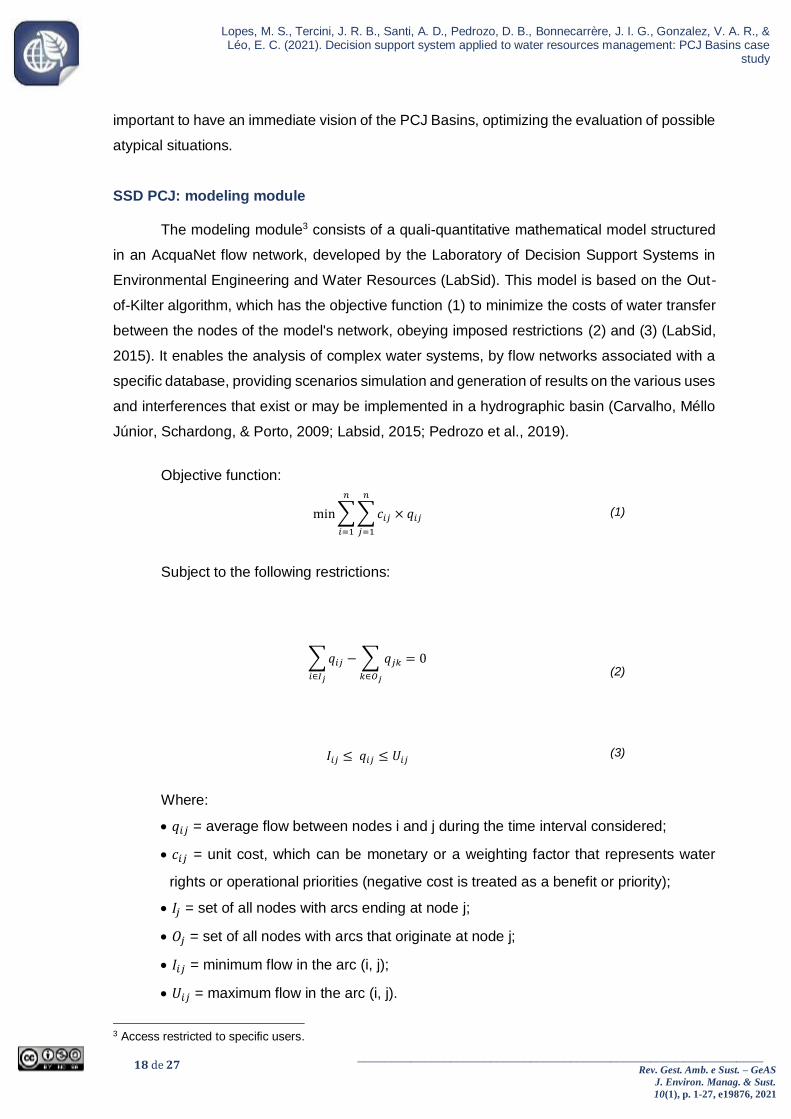
The modeling module3 consists of a quali-quantitative mathematical model structured
in an AcquaNet flow network, developed by the Laboratory of Decision Support Systems in
Environmental Engineering and Water Resources (LabSid). This model is based on the Out-
of-Kilter algorithm, which has the objective function (1) to minimize the costs of water transfer
between the nodes of the model's network, obeying imposed restrictions (2) and (3) (LabSid,
2015). It enables the analysis of complex water systems, by flow networks associated with a
specific database, providing scenarios simulation and generation of results on the various uses
and interferences that exist or may be implemented in a hydrographic basin (Carvalho, Méllo
Júnior, Schardong, & Porto, 2009; Labsid, 2015; Pedrozo et al., 2019).
Objective function:
min ∑ ∑ 𝑐𝑖𝑗 × 𝑞𝑖𝑗
𝑛
𝑗=1
𝑛
𝑖=1
(1)
Subject to the following restrictions:
∑ 𝑞𝑖𝑗 − ∑ 𝑞𝑗𝑘
𝑘∈𝑂𝑗𝑖∈𝐼𝑗
= 0 (2)
𝐼𝑖𝑗 ≤ 𝑞𝑖𝑗 ≤ 𝑈𝑖𝑗 (3)
Where:
• 𝑞𝑖𝑗 = average flow between nodes i and j during the time interval considered;
• 𝑐𝑖𝑗 = unit cost, which can be monetary or a weighting factor that represents water
rights or operational priorities (negative cost is treated as a benefit or priority);
• 𝐼𝑗 = set of all nodes with arcs ending at node j;
• 𝑂𝑗 = set of all nodes with arcs that originate at node j;
• 𝐼𝑖𝑗 = minimum flow in the arc (i, j);
• 𝑈𝑖𝑗 = maximum flow in the arc (i, j).
3 Access restricted to specific users.

19 de 27 _____________________________________________________________
Rev. Gest. Amb. e Sust. – GeAS
J. Environ. Manag. & Sust.
10(1), p. 1-27, e19876, 2021
Lopes, M. S., Tercini, J. R. B., Santi, A. D., Pedrozo, D. B., Bonnecarrère, J. I. G., Gonzalez, V. A. R., & Léo, E. C. (2021). Decision support system applied to water resources management: PCJ Basins case study
As AcquaNet is an integrated model, in addition to water allocation, the quality module
can also be coupled. Thereby the system additionally has an advection, dispersion and decay
model to calculate the water quality parameters (dissolved oxygen, biochemical oxygen
demand, coliforms, nitrogen series and organic and inorganic phosphorus), which were
considered in its conception, allowing simulating quality changes in the river stretches,
depending on water availability. This functionality reiterates that the SSD PCJ contributes to
improving decision processes, given that the scenarios permit to evaluate the best alternative
to ensure the multiple use of water in adequate quality standards, in line with ANA (2016), Ono
(2008) and Porto and Porto (2008).
In the SSD PCJ, the PCJ Basins are represented by 225 CAs, defined from an Otto-
codified hydrographic base. All the calculations of quali-quantitative models, water balance
and water quality simulation are performed for each of the sub-basins; that is, all the demands,
releases and other information are grouped by CAs (Consórcio Profill-Rhama, 2020).
To create a scenario, it is necessary to manually load the data into the interface
(Pedrozo et al., 2019). As an example of input data, the following are cited: urban population
of municipalities, sewage supply and treatment rates, distribution loss rates, efficiency of
treatment processes, specific demands of the various existing uses and use of soil etc. (Figure
9).

20 de 27 _____________________________________________________________
Rev. Gest. Amb. e Sust. – GeAS
J. Environ. Manag. & Sust.
10(1), p. 1-27, e19876, 2021
Lopes, M. S., Tercini, J. R. B., Santi, A. D., Pedrozo, D. B., Bonnecarrère, J. I. G., Gonzalez, V. A. R., & Léo, E. C. (2021). Decision support system applied to water resources management: PCJ Basins case
study
Figure 9
Scenario input data samples
Source: SSD PCJ (https://ssd.baciaspcj.org.br/, retrieved October 16, 2021).
The model also has a set of “general data”, considered in all the scenarios as a
background, i.e., the general database that impacts the simulations. It contains data on natural
flows, demand groups (irrigation, industrial, domestic, animal watering, private urban), the
details of reservoirs and transpositions, etc. These data do not characterize the scenarios but
are basis that provides inputs for model simulations and calibration.
After loading the data and carrying out the simulations, the results can be analyzed at
different scales – municipal, water and sewage treatment plants, specific demands made for
that scenario and in intermediate stretches of a sub-basin (Consórcio Profill-Rhama, 2020).
Figure 10 shows an example of results.

21 de 27 _____________________________________________________________
Rev. Gest. Amb. e Sust. – GeAS
J. Environ. Manag. & Sust.
10(1), p. 1-27, e19876, 2021
Lopes, M. S., Tercini, J. R. B., Santi, A. D., Pedrozo, D. B., Bonnecarrère, J. I. G., Gonzalez, V. A. R., & Léo, E. C. (2021). Decision support system applied to water resources management: PCJ Basins case study
Figure 10
Scenario results samples
Source: SSD PCJ (https://ssd.baciaspcj.org.br/, retrieved October 16, 2021).
This module was extensively used in the PCJ Basins Plan 2020-2035 (Consórcio
Profill-Rhama, 2020) in the simulations of future scenarios (2025, 2030 and 2035), to assess
the impacts of interventions and forecasted demands on the quantity and quality of water,
providing subsidies for planning actions to be implemented in the region, as highlighted by
Lima (2007) and INBO & UNESCO (2018). To generate such scenarios, the model was fed
with data monitored by the municipalities and water resources management agencies, in
addition to the forecast of investments in the sanitation sector, from the expansion of sanitary
sewage systems to the implementation of new reservoirs and reduction of rates of water losses
in distribution, integrating information both on water and on the factors involved in
management, corroborating the view of Moran et al. (2020).
Although the base of models is often extolled in the literature - composed of the
mathematical models used in scenario simulation -, it is worth emphasizing that this type of
system must be considered by the interrelationship of all its modules, to guarantee that all the
information listed by Moran et al. (2020) are in fact integrated. In the case of SSD PCJ, for
example, the different sections – Monitoring, Maps and Modeling – are directly or indirectly
correlated.

22 de 27 _____________________________________________________________
Rev. Gest. Amb. e Sust. – GeAS
J. Environ. Manag. & Sust.
10(1), p. 1-27, e19876, 2021
Lopes, M. S., Tercini, J. R. B., Santi, A. D., Pedrozo, D. B., Bonnecarrère, J. I. G., Gonzalez, V. A. R., & Léo, E. C. (2021). Decision support system applied to water resources management: PCJ Basins case
study
In this context the use of SSD PCJ in the Basin Plan is not limited to simulating quali-
quantitative future scenarios, as its main challenge concerns monitoring the implementation of
actions and the resulting impacts. Thus, there is a close relationship of the “Monitoring” section
with the implementation of the Plan, since the continuous monitoring of the situation of water
bodies subsidizes the follow-up of the compliance with their classification classes, indicating if
the planned actions are being effective, or if there is a need for adjustments so that the defined
goals are achieved.
Conclusion
The analyses presented highlighted the complexity of the water resources
management process, emphasizing the importance of consistent acquisition of hydrological
data and structure of robust and reliable database, which support water basins planning and
management. In this context, the SSD PCJ is an important tool to support the decision-making
process in the PCJ Basins area, providing the integration of a large amount of data, regardless
of its type, source, or periodicity.
This enables to visualize and to analyze data from the interest area in a single interface,
reducing the time spent on data acquisition and thus optimizing the analysis and actions of
several users. In addition, this system makes historical and real time data publicly available,
allowing comparisons between different periods and monitoring points, supporting both
operational management and planning actions for water resources.
The SSD PCJ has characteristics that enhance its application in water resources
management, in line with the principles and objectives of WRIS and DSS, especially to support
management tools development, decentralization of data and information acquisition, and
transparency in the use of the system, with the public availability of updated data and
information in an online interface.
As this work has shown that the three interrelated modules of the system contribute
significantly to the management actions of the PCJ Basins, the experiences described here
can be replicated in other river basins, contributing to the effectiveness of the management
and planning of water resources. The executing agency, in addition to acquiring or developing
a software with the requirements discussed here, will have to use a service that extract data
from suppliers and input them at the proposed system, and also have a qualified professional
to interpret them. There are clearly several technical challenges to be explored for
standardizing the nomenclature of hydrological variables and files for exchanging hydrological
information between systems.
Note that systems as the one presented here, once implemented, and used as a tool
for river basin management, gain several attributions, such as: evaluation of indicators and/or

23 de 27 _____________________________________________________________
Rev. Gest. Amb. e Sust. – GeAS
J. Environ. Manag. & Sust.
10(1), p. 1-27, e19876, 2021
Lopes, M. S., Tercini, J. R. B., Santi, A. D., Pedrozo, D. B., Bonnecarrère, J. I. G., Gonzalez, V. A. R., & Léo, E. C. (2021). Decision support system applied to water resources management: PCJ Basins case study
reference values of critical situations of water scarcity or water quality; identification of risk
situations and issuance of alerts to minimize adverse impacts; provision of useful information
for inspection processes, proposition of regulatory standards and investment planning; etc.
Therefore, the use of systems similar to the SSD PCJ in other hydrographic basins can
contribute to the expansion of the management capacity, mainly due to the structure of the
three-dimensional database and the integrated query and visualization of data of different
sources.
Finally, the authors emphasize the need to expand multidisciplinary research that
permeate the theme of information systems and water resources management, expanding
knowledge on the theme and contributing to disseminating the numerous functions of this type
of system. Therefore, future studies are recommended to evaluate how the dissemination of
water resources information influences the behavior of the citizens of the hydrographic basin,
and propose methodologies to standardize nomenclatures and files, to optimize the exchange
of information between systems.
Acknowledgments
We would like to thank Luiz Roberto Moretti (in memorian) for his enormous
contributions to the management of water resources in the PCJ Basins, LabSid/POLI/USP,
FCTH, the PCJ Committees and the PCJ Basins Agency.
References
Almeida, A. S., Sorribas, M. V., Lopes, M. S.; Gonçalves, J. E., Da Paz, S. R., Toshioinouye, R., Jusevicius, M. A., Areco, E. R.; D’Ávila, V. C., Leite, E. A., Beneti, C. A. A., Vilella, A. L., Mercanti, J. A., & Léo, E. C. (2019, novembro). Sistema de Previsão Hidrometeorológico para subsidiar a operação do Sistema Cantareira na gestão das Bacias PCJ. Anais do Simpósio Brasileiro de Recursos Hídricos, Foz do Iguaçu, PR, Brasil, 23. Recuperado em 15 outubro, 2021, de https://anais.abrhidro.org.br/job.php?Job=5490
Agência Nacional de Águas. (n.d.) Monitoramento da qualidade da água de rios e
reservatórios. Caderno Redes de Monitoramento [Apostila do Curso Monitoramento da qualidade da água de rios e reservatórios]. Brasília: ANA. Recuperado em 15 outubro, 2021, de https://capacitacao.ana.gov.br/conhecerh/handle/ana/2227
Agência Nacional de Águas. (2016). Sistemas de Informação na gestão de águas: conhecer
para decidir [Apostila do Curso Sistemas de Informação na gestão de águas: conhecer para decidir]. Brasília: ANA.
Bagstad, K., Semmens, D., Waage, S., & Winthrop, R. (2013). A comparative assessment of
decision-support tools for ecosystem services quantification and valuation. Ecosystem Services, 5, 27–39. Retrieved October 15, 2021, from https://doi.org/10.1016/j.ecoser.2013.07.004

24 de 27 _____________________________________________________________
Rev. Gest. Amb. e Sust. – GeAS
J. Environ. Manag. & Sust.
10(1), p. 1-27, e19876, 2021
Lopes, M. S., Tercini, J. R. B., Santi, A. D., Pedrozo, D. B., Bonnecarrère, J. I. G., Gonzalez, V. A. R., & Léo, E. C. (2021). Decision support system applied to water resources management: PCJ Basins case
study
Basco-Carrera, L., Warren, A., Beek, E., Jonoski, A., & Giardino, A. (2017). Collaborative modelling or participatory modelling? A framework for water resources management. Environmental Modelling & Software, 91, 95-110. Retrieved October 15, 2021, from https://doi.org/10.1016/j.envsoft.2017.01.014
Bolognesi, Thomas, & Kluser, Stéphane. (2018). Water security as a normative goal or as a
structural principle for water governance. A Critical Approach to International Water Management Trends: Policy and Practice; Palgrave Studies in Water Governance: Policy and Practice; Palgrave MacMillan. Londres, UK. Retrieved October 15, 2021, from https://doi.org/10.1057/978-1-137-60086-8_9
Braga, B., Barbosa, P. S. F., & Nakayama, P. T. (1998). Sistemas de suporte à decisão em
recursos hídricos. Revista Brasileira de Recursos Hídricos, 3(3), 73-95. Recuperado em 15 outubro, 2021, de https://doi.org/10.21168/rbrh.v3n3.p73-95
Braga, B., & Kelman J. (2016). Facing the challenge of extreme climate: the case of
Metropolitan São Paulo. Water Policy, 18(S2), 52-69. Retrieved October 15, 2021, from https://doi.org/10.2166/wp.2016.113
Carvalho, M. A., Méllo Júnior, A. V., Schardong, A., & Porto, R. L. L. (2009). Sistema de
suporte à decisão para alocação de água em projetos de irrigação. Engenharia de Irrigação e Drenagem, 13(1), 10-17. Recuperado em 15 outubro, 2021, de https://doi.org/10.1590/S1415-43662009000100002
Collischonn, W. (2013). Hidrologia para engenharia e ciências ambientais (2a ed.). Porto Alegre: Associação Brasileira de Recursos Hídricos.
Companhia Brasileira de Projetos e Empreendimentos – Cobrape. (2010). Plano das Bacias
Hidrográficas dos Rios Piracicaba, Capivari e Jundiaí 2010 – 2020, com Propostas de Atualização do Enquadramento dos Corpos d’Água e de Programa para Efetivação do Enquadramento dos Corpos d’Água até o Ano de 2035 (Relatório Final), s.l. Recuperado em 15 outubro, 2021, de https://www.comitespcj.org.br/images/Download/PB/PCJ_PB-2010-2020_RelatorioFinal.pdf
Consórcio Profill-Rhama. (2020): Plano de Recursos Hídricos das Bacias Hidrográficas dos
Rios Piracicaba, Capivari e Jundiaí, 2020 a 2035 (Relatório Síntese), Piracicaba, SP. Recuperado em 15 outubro, 2021, de https://drive.google.com/file/d/1RUE-Xg7rjXDKlGJS3bs8sS7wKEB6Oxqx/view
Costanza, R., Rudolf, D., Braat, L., Kubiszewski, I., Fioramonti, L., Sutton, P., Farber, S., &
Grasso, M. (2017). Twenty years of ecosystem services: How far have we come and how far do we still need to go? Ecosystem Services, 28, 1-16. Retrieved October 15, 2021, from https://doi.org/10.1016/j.ecoser.2017.09.008
Dadson, S., Hall, J., Garrick, D., Sadoff, C., Grey, D., & Whittington, D. (2017). Water
security, risk, and economic growth: Insights from a dynamical systems model. Water Resources Research, 53, 6425–6438. Retrieved October 15, 2021, from https://doi.org/10.1002/2017WR020640
Denzer, R. (2005). Generic integration of environmental decision support systems – state-of-
the-art. Environmental Modelling & Software, 20(10), 1217-1223. Retrieved October 15, 2021, from https://doi.org/10.1016/j.envsoft.2004.09.004
Fundação Agência das Bacias PCJ. (2020). Gestão das Bacias PCJ 2020 – Ano base 2019,
Piracicaba, SP. Recuperado em 15 outubro, 2021, de

25 de 27 _____________________________________________________________
Rev. Gest. Amb. e Sust. – GeAS
J. Environ. Manag. & Sust.
10(1), p. 1-27, e19876, 2021
Lopes, M. S., Tercini, J. R. B., Santi, A. D., Pedrozo, D. B., Bonnecarrère, J. I. G., Gonzalez, V. A. R., & Léo, E. C. (2021). Decision support system applied to water resources management: PCJ Basins case study
https://agencia.baciaspcj.org.br/wp-content/uploads/Revista_Bacias_PCJ_nova_versao_menu_navegavel.pdf
Gain, A.K., Giupponi, C., & Wada, Y. (2016). Measuring global water security towards
sustainable development goals. Environmental Research Letters, 11(12), 124015. Retrieved October 15, 2021, from http://dx.doi.org/10.1088/1748-9326/11/12/124015
Ghasemi, A., Saghafian, B., & Golian, S. (2017). System dynamics approach for simulating
water resources of an urban water system with emphasis on sustainability of groundwater. Environmental Earth Sciences, 76, 637. Retrieved October 15, 2021, from https://doi.org/10.1007/s12665-017-6887-z
Ghashghaie, M., Marofi, S., & Marofi, H. (2014). Using System Dynamics Method to
Determine the Effect of Water Demand Priorities on Downstream Flow. Water Resources Management, 28, 5055–5072. Retrieved October 15, 2021, from https://doi.org/10.1007/s11269-014-0791-z
Goodall J. L., Horsburgh J. S., Whiteaker T. L., & Maidment D. R., & Zaslavsky I. (2008). A
first approach to web services for the National Water Information System. Environmental Modelling & Software, 23(4), 404-11. Retrieved October 15, 2021, from https://doi.org/10.1016/j.envsoft.2007.01.005
Gössling, S. (2015). New performance indicators for water management in tourism. Tourism
Management, 46, 233-244. Retrieved October 15, 2021, from https://doi.org/10.1016/j.tourman.2014.06.018
International Network Of Basin Organizations & United Nations Educational, Scientific and
Cultural Organization – INBO E UNESCO. (2018). The handbook on water information systems: administration, processing and exploitation of water-related data. WMO. Retrieved October 15, 2021, from https://www.riob.org/sites/default/files/_HB-2018-SIE-BAT_web.pdf
INTERNATIONAL OFFICE FOR WATER – IOWater. (2013). Regional project on Creating
Shared National Water Information Systems towards a Mediterranean Water Knowledge Platform. IOWater.
Karamouz, M., Kerachian, R., & Zahraie, B. (2004). Monthly water resources and irrigation
planning: Case study of conjuctive use of surface and groundwater resources. Journal of Irrigation and Drainage Engineering, 130(5), 391–401. Retrieved October 15, 2021, from https://doi.org/10.1061/(ASCE)0733-9437(2004)130:5(391)
Laboratório de Sistemas de Suporte a Decisões em Engenharia Ambiental e de Recursos
Hídricos. (2013). AcquaNet [Manual]. São Paulo, SP. Lei n° 9.433, de 08 de janeiro de 1997 (1997). Institui a Política Nacional de Recursos
Hídricos, cria o Sistema Nacional de Gerenciamento de Recursos Hídricos, regulamenta o inciso XIX do art. 21 da Constituição Federal, e altera o art. 1º da Lei nº 8.001, de 13 de março de 1990, que modificou a Lei nº 7.990, de 28 de dezembro de 1989. Diário Oficial da União. Brasília, DF.
Lima, G. (2007). Riverhelp!: sistema de suporte a decisões para planejamento e
gerenciamento integrado de recursos hídricos. Tese de doutorado, Universidade de São Paulo, São Carlos, SP, Brasil. Disponível: https://teses.usp.br/teses/disponiveis/18/18138/tde-23042009-142552/pt-br.php

26 de 27 _____________________________________________________________
Rev. Gest. Amb. e Sust. – GeAS
J. Environ. Manag. & Sust.
10(1), p. 1-27, e19876, 2021
Lopes, M. S., Tercini, J. R. B., Santi, A. D., Pedrozo, D. B., Bonnecarrère, J. I. G., Gonzalez, V. A. R., & Léo, E. C. (2021). Decision support system applied to water resources management: PCJ Basins case
study
Longo Júnior, M. S. (2011). Monitoramento da qualidade da água na Microbacia Furninha – Município de Ourinhos/SP. Trabalho de Conclusão de Curso, Universidade Estadual Paulista “Júlio de Mesquita Filho”, Ourinhos, SP, Brasil. Disponível: https://repositorio.unesp.br/handle/11449/155024
Lopes, M. S., Léo, E. C., Garcia, J. I. B., Santi, A. D., Pedrozo, D. B., Tercini, J. R. B., &
Gonzalez, V. A. R. (2019, novembro). Monitoramento telemétrico como ferramenta de gestão de recursos hídricos. Anais do Simpósio Brasileiro de Recursos Hídricos, Foz do Iguaçu, PR, Brasil, 23. Recuperado em 15 outubro, 2021, de https://anais.abrhidro.org.br/job.php?Job=4926
Loucks, D. P. (2006, julho). Generic simulation models for facilitating stakeholder
involvement in water resources planning and management: a comparison, evaluation and identification of future needs. International Congress on Environmental Modelling and Software. 451. Burlington, Vermont, Estados Unidos, 3. Retrieved October 15, 2021, from https://scholarsarchive.byu.edu/iemssconference/2006/all/224.
Moran, T., Saracino, A., Sugg, Z., Thompson, B., & Martinez, J. (2020). Evaluating the Use
of Data Platforms for Water Management Decisions. Water in the West. California: Stanford Digital Repository.
Ono, S. (2008). Sistema de Suporte à Decisão para gestão de água urbana - URBSSD.
Dissertação de mestrado, Universidade de São Paulo, São Paulo, Brasil. Disponível: https://www.teses.usp.br/teses/disponiveis/3/3147/tde-15082008-094908/publico/Dissertacao_Sidnei_Ono.pdf
Pallotino, S., Sechi, G., & Zuddas, P. (2005). A DSS for water resources management under
uncertainty by scenario analysis. Environmental Modelling and Software, 20(8), 1031–1042. Retrieved October 15, 2021, from https://doi.org/10.1016/j.envsoft.2004.09.012
Pedrozo, D.B., Santi, A.D., Lopes, M.S., Léo, E.C., Tercini, J.R.B., Gonzalez, V.A.R., &
Garcia, J.I.B. (2019, novembro). Os Sistemas de Informações sobre Recursos Hídricos – Análise da abordagem no contexto das Bacias PCJ. Anais do Simpósio Brasileiro de Recursos Hídricos, Foz do Iguaçu, PR, Brasil, 23. Recuperado em 15 outubro, 2021, de https://anais.abrhidro.org.br/job.php?Job=5054
Porto, M. F. A., & Porto, R. L. L. (2008). Gestão de bacias hidrográficas. Estudos avançados,
22(63), 43-60. Recuperado em 15 outubro, 2021, de https://doi.org/10.1590/S0103-40142008000200004
Resolução Conjunta ANA/DAEE nº 925, de 29 de maio de 2017 (2017). Dispõe sobre as
condições de operação para o Sistema Cantareira. Diário Oficial da União. Brasília, DF.
Russel, C. S., Vaughan, W. J., Clark, C. D., Rodriguez, D. J., & Darling, A. H. (2001).
Investing in water quality: measuring benefits, costs and risks. Washington: Inter-American Development Bank.
Santi, A. D., Lopes, M. S., Pedrozo, D. B., Léo, E. C., Barufaldi, P. G. A. (2020, novembro).
Análise da integração dos Planos de Bacias e Sistemas de Informações na gestão e planejamento dos recursos hídricos: a experiência das Bacias PCJ. Anais da Jornada de Gestão e Análise Ambiental, São Carlos, SP, Brasil, 6.
Sordo-Ward, Á., Granados, I., Martín-Carrasco, F., & Garrote, L. (2016). Impact of

27 de 27 _____________________________________________________________
Rev. Gest. Amb. e Sust. – GeAS
J. Environ. Manag. & Sust.
10(1), p. 1-27, e19876, 2021
Lopes, M. S., Tercini, J. R. B., Santi, A. D., Pedrozo, D. B., Bonnecarrère, J. I. G., Gonzalez, V. A. R., & Léo, E. C. (2021). Decision support system applied to water resources management: PCJ Basins case study
Hydrological Uncertainty on Water Management Decisions. Water Resources Management, 30(14), 5535–5551. Retrieved October 15, 2021, from https://doi.org/10.1007/s11269-016-1505-5
Tercini, J.R.B., Gonzalez, V.A.R., Silva, C.V.F., Garcia, J.I.B., Mello Júnior, A.V., Oliveira,
C.P.M., Luongo F.A.P., Lopes, M. S., Pedrozo, D.B., & Santi, A.D., & Léo, E.C. (2019, novembro). Modelo multidimensional de banco de dados hidrológicos em PostgreSQL: estudo de caso SSDPCJ. Anais do Simpósio Brasileiro de Recursos Hídricos, Foz do Iguaçu, PR, Brasil, 23. Recuperado em 15 outubro, 2021, de https://anais.abrhidro.org.br/job.php?Job=4934
Quesada-Montano, B., Westerberg, I.K., Fuentes-Andino, D., Hidalgo, H.G., & Halldin, S.
(2018). Can climate variability information constrain a hydrological model for an ungauged Costa Rican catchment? Hydrological Processes, 32, 830–846. Retrieved October 15, 2021, from https://doi.org/10.1002/hyp.11460
Walker, R., Beck, M., Hall, J., Dawson, R., & Heidrich, O. (2014). The Energy-Water-Food
Nexus: Strategic Analysis of Technologies for Transforming the Urban Metabolism. Journal of Environmental Management, 141(1), 104–115. Retrieved October 15, 2021, from https://doi.org/10.1016/j.jenvman.2014.01.054