Embed Size (px)
Citation preview

DECISIONS ON THEPROPOSED DISTRICT PLAN
Planning Maps
October 2014

1
Doc No.RDC-496091 PROPOSED ROTORUA DISTRICT PLAN – COUNCIL DECISIONPLANNING MAPS
PLANNING MAPS
Contents
1. Executive Summary ....................................................................................................................2
2 Scope of Hearing ........................................................................................................................2
3 User Guide ..................................................................................................................................3
4 TOPICS ......................................................................................................................................4
4.1 Topic 1 – Strategic map series ....................................................................................................4
4.2 Topic 2 –Special Interest Map Series .........................................................................................8
4.3 Topic 3 – General maps (300 series) .......................................................................................16
4.3 Topic 4 – General comments ...................................................................................................26
4.5 Submissions that do not result in a material change to the purpose and intent of the plan .......29
4.6 Submissions that have been considered in a separate decision report.......................................31
APPENDIX 1 - Summary of Decisions.................................................................................................35

2
Doc No.RDC-496091 PROPOSED ROTORUA DISTRICT PLAN – COUNCIL DECISIONPLANNING MAPS
1. Executive Summary
1.1 This decision report contains Rotorua District Hearings Committee (the Committee) decisions under Clause 10 of the First Schedule of the Resource Management Act 1991 (the ‘Act’) on the Planning Maps contained within the Proposed Rotorua District Plan (‘the Proposed Plan’).
1.2 At its meeting on 12 December 2013 the Council resolved to give delegated authority to Councillors and Independent Commissioners to hear and make decisions on the submissions and further submissions (hereafter referred to as submissions) to the Proposed Plan. The Council formed a Hearing Committee that heard evidence on different sections of the Proposed Plan over a six month period.
1.3 The Committee notes that in making this decision it is limited to the submissions that have been lodged and the relief that has been requested. In considering further submissions the Council notes that these submissions can only support or oppose submissions, and cannot extend the scope of the original submission.
1.4 After hearing all submitters the Committee notes that: This report should be read alongside the strikethrough version of the Proposed Plan which shows the Committee decision in Appendix 2. Where a submission point has been accepted or accepted in part in this report, refer to Appendix 2 to confirm whether any other submission points have resulted in an amendment to that provision. If as a result of the hearings the Committee has identified the need for a minor amendment under Clause 16 of the Act this is referenced as Cl 16. In some instances amendments may have been made to provisions as a result of other hearings and decision reports.
1.5 A summary of the submission points addressed under each topic and the decision is attached in Appendix 1 at the end of the report.
2 Scope of Hearing
2.1 The hearing on Planning Maps was held on 4 and 5 August 2014. The Commissioners who sat on this Committee are listed below:
Chairman Glenys SearanckeCommissioner Karen HuntCommissioner Janet Wepa
2.2 The hearing addresses the planning maps of the proposed plan. The District Plan provisions within scope of this hearing are contained within the proposed planning maps of the Plan.
2.3 The hearing addresses 4 topics which group together submission and further submission points made in detail to the proposed planning maps. These topics are as follow;
a. Strategic Map seriesb. Special Interest Map Seriesc. General Mapsd. General comments

3
Doc No.RDC-496091 PROPOSED ROTORUA DISTRICT PLAN – COUNCIL DECISIONPLANNING MAPS
3 User Guide
3.1 Decisions on the submissions are presented by Chapter (the same as was produced for the Section 42A reports) in order to ensure transparency. The decision reports are in the form of tables. The column headings are as follows: Submission/Further submission point (eg 379.64) Summary of the submission point Submitter position (whether the submission opposes, accepts or supports in part the
provision) Decision (whether the Committee accepts, accepts in part, rejects the submission) Reason (the explanation for the Committee's decision)
3.2 In some cases the reasons are contained in the table in each section and in other cases they are contained in paragraphs that are referenced within the table and follow each table. The reasons for the decisions and the strikethrough version of the Proposed Plan form part of the Council’s ongoing section 32 evaluation.
3.3 The columns in the table - submitter number and point, summary and position are all taken directly from the summary of submissions required as part of the statutory process. The ‘Decision’ column is the Committee's decision whether the submission has been accepted, accepted in part, or rejected. The last column, ‘Reason’ is a brief explanation of the decision or has a reference to the text following the tables where the reason is expanded.
3.4 The amendments in text as a result of the Committee’s decision can be seen in the track changes version of the District Plan. The changes to the text are referenced to the submission point that requested the change or as a consequential amendment generated from the submission point. In some instances when the change to the text is minor and has not changed the intent of the provision of the plan these are a result of RMA clause 16 and are not referenced in the text.
3.5 Section 32 of the Act requires the Council in preparing a proposed plan to carry out an evaluation both before it is publicly notified and before making a decision on submissions. The evaluation is to examine the extent to which each objective is the most appropriate way to achieve the purpose of the Act, and whether, having regard to their efficiency and effectiveness, the policies, rules and other methods are the most appropriate for achieving the objectives. The evaluation is to take into account the benefits and costs of policies, rules or other methods; and also the risk of acting or not acting if there is uncertain or insufficient information about the subject matter of the policies, rules or methods.
3.6 The RDC carried out an evaluation of the Proposed Plan before it was publicly notified and duly published a series of summary reports.
3.7 The Resource Management Amendment Act 2013 (RMAA 2013) amended the provisions of section 32 of the RMA. The RMAA 2013 took effect on 4 December 2013. The reporting officers advised us that as at 4 December 2013 the Proposed Plan had been notified and the further submission period had been completed. Consequently, under the RMAA 2013 transitional provisions the previous section 32 provisions apply to these proceedings. We accept and concur with that advice.
3.8 We note that, where appropriate, the Section 42A Reports undertook a section 32 analysis of the relief sought by submissions. We found that analysis helpful.
3.9 We record that we have taken into account the requirements of section 32 of the RMA when making our determinations on the submissions. We have not however attempted to prepare a separate section 32 analysis report relating to our determinations.
Part 2

4
Doc No.RDC-496091 PROPOSED ROTORUA DISTRICT PLAN – COUNCIL DECISIONPLANNING MAPS
3.10 Part 2 of the RMA sets out the purpose and principles of general application in giving effect to the Act. We understand that Part 2 is intended to inform the approach to the Act's interpretation and implementation.
3.11 The Act has a single purpose, and whether a particular provision serves that purpose requires an overall broad judgement allowing for comparison of conflicting considerations, their scale and degree, and their relative significance in the final outcome. The matters provided for in sections 6 to 8 are not ends or objectives in their own right, nor matters to be protected at all costs.
3.12 Section 6 of the RMA identifies matters of national importance, and we are required to recognise and provide for them. Section 7 lists matters to which we must have particular regard. Section 8 requires that we take into account the principles of the Treaty of Waitangi (Te Tiriti o Waitangi).
3.13 We have sought to give effect to Part 2 of the RMA in making our determinations on the submissions and further submissions.
4 TOPICS
4.1 Topic 1 – Strategic map series
Summary Table - submission points
Submitter Number - Point
Summary of Submission Submitter position
Decision Reason
420-119 Map 101 refers to the Kaituna River Document. It is unclear as to what document is being referred to and should be removed or identified.
Support with amendment
Accept 4.1.13
379-15 Delete planning Map 100 Series: Map 101, 102, 103 - These planning maps provide often anecdotal information that is given statutory weight by being part of the plan. Some of it is purely interpretation of the visitor numbers etc. and adds nothing to the implementation of the Plan. The maps belong in a promotional brochure, section 32 background information or an explanatory document outside the plan. Some refer to potential policy changes. This is undesirable, creates uncertainty and is unnecessary. Eg there are TDR recipient areas shown as possible- this is not matched by provisions in the District Plan nor the planning maps (300-500). These maps should not carry or be given statutory weight.
Oppose Accept in Part 4.1.1
217-7 Remove the GDP information from Map 101 (Strategic Overview) as these are moving targets over the next 10 years. If left in then information must be latest figures, dated and referenced with the addition of forestry & wood products. These are outdated and the Infometrics Report on the RDC website lists agriculture as 16.2%, tourism is 3.3%, forestry & wood products is 11.8%.
Oppose Accept 4.1.2
439-9 Allocate land for the different types of industrial activities to provide direction for future developers. If large industries want to develop, then we are able to plan them in the right place.
Support with amendment
Reject 4.1.3
Submitter Number - Point
Summary of Submission Submitter position
Decision Reason

5
Doc No.RDC-496091 PROPOSED ROTORUA DISTRICT PLAN – COUNCIL DECISIONPLANNING MAPS
Submitter Number - Point
Summary of Submission Submitter position
Decision Reason
440-9 Allocate land for the different types of industrial activities to provide direction for future developers. If large industries want to develop, then we are able to plan them in the right place.
Support with amendment
Reject 4.1.3
111-29 Include Maraeroa Oturoa 2B on Map 103 as an operating dairy farm.
Support with amendment
Accept 4.1.4
Amend the key to refer to Geothermal Systems (rather than geothermal fields) and include a note in the legend saying "geothermal system boundaries shown on the plan are approximate only" Show the same boundaries for geothermal systems which have been mapped in the Waikato Regional Plane.
Support with amendment
Accept 4.1.5 and 4.1.6
182-55
FS 591 - 14Support for reasons stated in the submission Support Accept 4.1.5
218-9 Correct Economic Future: Dairy Farms on planning map 103. Northwest area of SH5, east and west of Oturoa Road are dairy farms.
Support with amendment
Accept 4.1.4
420-120 Map 103 T8C supports the intent of identification of 'potential geothermal and heavy industry land uses under investigation'. The statement is or soon will be out of date it is not future growth but current & planned activity.
Support with amendment
4.1.8
500-133 Identify what criteria were used to create the geothermal system boundaries for map 103. If this is indicative only, the map should clearly state that it is indicative only. Seek to include all geothermal systems in the Rotorua District i.e. add the Waimangu, Waiotapu, Waikite system. Include a geothermal tourism icon at Whakarewarewa.Boundaries on geothermal systems are smaller than the geothermal systems. Taheke / Tikitere should show as one area. Some geothermal systems are missing = Waimangu, Waiotapu, Waikite. Need to state source of geothermal system information. Location of geothermal tourism icon in Rotorua in wrong place. At present there is no geothermal symbol at Whakarewarewa. No geothermal tourism for Waitangi Springs at Rotoma? For Map 103. If this is indicative only, the map should clearly state that it is indicative only.
Support with amendment
Accept 4.1.6 and 4.1.7
508-2 Correct Map 103 to show the farms in the Northwest area as dairy farms, including Waiteti. This is incorrect by omission.
Support with amendment
Accept 4.1.4
Retain the notations relating to the nature of actual and/or potential land uses associated with the Taheke and Ohaaki Geothermal Systems, but clarify what "diversification" notation is referring to in the Ohaaki Industrial zone.
Support with amendment
Accept 4.1.9182-56
FS 568 - 1Support for reasons stated in the submission. Support Accept 4.1.9
186-14 Amend map 103 by deleting the notation and preferably the map removed from the PDP. It provides anecdotal information and is inappropriate for a statutory planning document. The Cookson Road area is shown as "Possible transferable rights recipient area?" and this is not supported by any plan provisions and is misleading as it will create an expectation that the area is suitable for smaller lot subdivision.
Oppose Accept in Part 4.1.14
6
Doc No.RDC-496091 PROPOSED ROTORUA DISTRICT PLAN – COUNCIL DECISIONPLANNING MAPS
Submitter Number - Point
Summary of Submission Submitter position
Decision Reason
Map 103 identifies future growth and the Avondale land as a 'possible transferrable development rights recipient area' while the Transferrable Development Rights (TDR) regime as proposed is not supported the Proposed District Plan PDP does signal the suitability of the land for subdivision and more intensive rural settlement
Support with amendment
Accept in part 4.1.14
FS 564 - 15Disagree strongly with any suitability of the Cookson Road area land for subdivision and more intensive rural settlement.
Oppose Accept 4.1.14
FS 612 - 2Support rural residential development to the eastside of Lake Rotorua.
Support Reject 4.1.14
FS 615 - 2Support rural residential development to the eastside of Lake Rotorua. Will improve aspect of Te Ngae Road - currently ad hoc dwellings, differing signs.
Support Reject 4.1.14
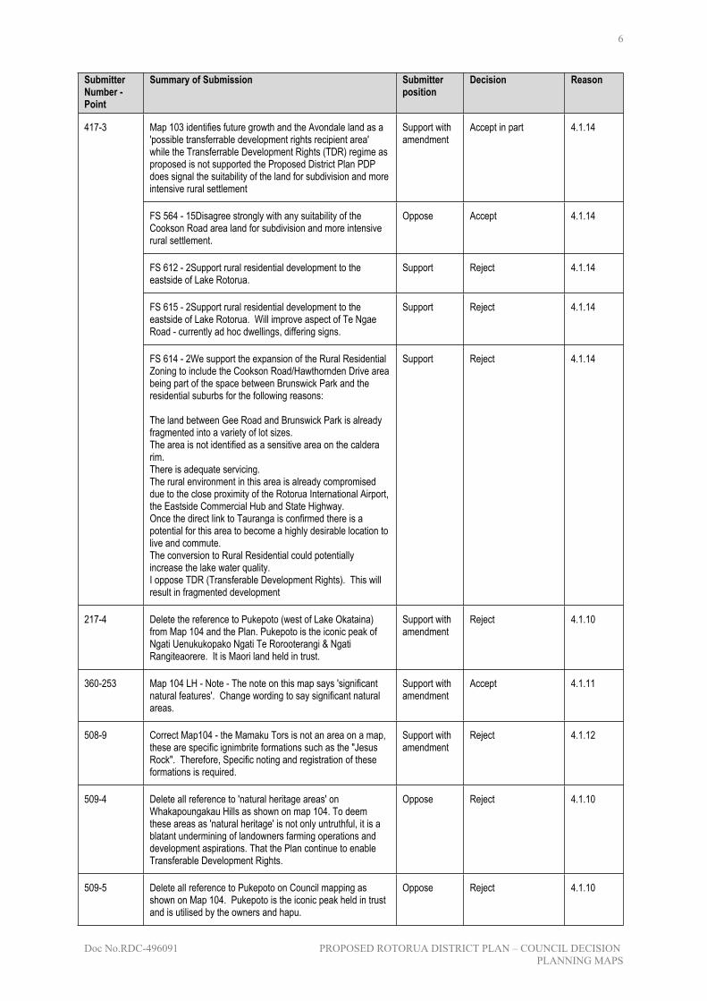
417-3
FS 614 - 2We support the expansion of the Rural Residential Zoning to include the Cookson Road/Hawthornden Drive area being part of the space between Brunswick Park and the residential suburbs for the following reasons:
The land between Gee Road and Brunswick Park is already fragmented into a variety of lot sizes.The area is not identified as a sensitive area on the caldera rim.There is adequate servicing.The rural environment in this area is already compromised due to the close proximity of the Rotorua International Airport, the Eastside Commercial Hub and State Highway.Once the direct link to Tauranga is confirmed there is a potential for this area to become a highly desirable location to live and commute.The conversion to Rural Residential could potentially increase the lake water quality.I oppose TDR (Transferable Development Rights). This will result in fragmented development
Support Reject 4.1.14
217-4 Delete the reference to Pukepoto (west of Lake Okataina) from Map 104 and the Plan. Pukepoto is the iconic peak of Ngati Uenukukopako Ngati Te Rorooterangi & Ngati Rangiteaorere. It is Maori land held in trust.
Support with amendment
Reject 4.1.10
360-253 Map 104 LH - Note - The note on this map says 'significant natural features'. Change wording to say significant natural areas.
Support with amendment
Accept 4.1.11
508-9 Correct Map104 - the Mamaku Tors is not an area on a map, these are specific ignimbrite formations such as the "Jesus Rock". Therefore, Specific noting and registration of these formations is required.
Support with amendment
Reject 4.1.12
509-4 Delete all reference to 'natural heritage areas' on Whakapoungakau Hills as shown on map 104. To deem these areas as 'natural heritage' is not only untruthful, it is a blatant undermining of landowners farming operations and development aspirations. That the Plan continue to enable Transferable Development Rights.
Oppose Reject 4.1.10
509-5 Delete all reference to Pukepoto on Council mapping as shown on Map 104. Pukepoto is the iconic peak held in trust and is utilised by the owners and hapu.
Oppose Reject 4.1.10

7
Doc No.RDC-496091 PROPOSED ROTORUA DISTRICT PLAN – COUNCIL DECISIONPLANNING MAPS
Planning Considerations
4.1.1 The Committee has heard the evidence presented by submitter 379.15 however it supports the recommendation in the S42 report because the 100 planning map series have been included to provide a snapshot of the current situation of the District (at time of notification) and an overview of where zones are located across Rotorua. These are not intended to have any legal weight or contribute to the enforcement of any policies or rules. Text stating this will be included on each of these planning maps ensuring that plan users are aware of the status of these maps. The text referring to the possible future TDR areas will be removed
4.1.2 The Committee notes that planning map 217.7 is only intended to provide a snapshot of the current situation of the Rotorua district. However as these figures will date and available information is conflicting the Committee accepts the planner’s recommendation that the GDP figures relating to the tourism, forestry and agriculture be removed.
4.1.3 The Committee has heard the evidence presented by the submitters 439.9 and 440.9 however it supports the recommendation in the S42 report because the district plan has two industrial zones (these shown on the 300 planning map series) that provide direction to the establishment of different types of industrial activity based on the potential effects of each on the amenity of the environment. In addition business parks have also been identified with this providing for the establishment and light industrial activities. Therefore it is considered that the plan already allocates land for different industrial uses. Any land intended to be zoned for future industrial use will be identified in the Rotorua Spatial Plan.
4.1.4 The Committee accepts submission points 111.29, 218.9, 508.2 noting that the inclusion of the specific sites and additional dairy farms is supported. Where the physical address/lot description has been provided these will be included. In relation to submissions 218.9 and 508.2 the location of dairy farms within this area will be identified through the use of 2001 aerial photography. This photography being the latest available to Council.
4.1.5 The Committee accepts submission 182.55 noting that to align with the regional policy statement the word field will be replaced with system. This change will also need to be made throughout the plans text to ensure consistency.
4.1.6 The Committee notes that the locations of the geothermal systems were identified through information gained from the Bay of Plenty Regional Council and the associated RPS. It is acknowledged that the location is indicative only and text will be included to the map stating this.
4.1.7 The Committee accepts submission 500.133 and notes that the geothermal icons included on planning map 103 are only intended to relate to geothermal tourism destinations. It is acknowledged that this was not included in the legend, this error has been rectified. In addition a symbol has been included over Whakarewarewa, assessment of the map has concluded that the symbols adequately identify the current geothermal industry.
4.1.8 The Committee have considered submission point 420.120 and have resolved for the text will be altered to reflect that investigation has been completed. The revised words will be ‘potential geothermal and heavy industrial land uses.’
4.1.9 The Committee accepts submission point 182.56 noting that upon review it is unclear what the term diversification was intended to cover. The Committee accepts the planner’s recommendation that this word be removed.
4.1.10 The Committee has heard the evidence presented in planning map 217.4 and 509.5 however it supports the recommendation in the S42 report because Pukepoto/Whakapoungakau Hills is an outstanding landscape that forms part of the Significant Lakes A landscape. This map has no legal weight and is intended to provide a snapshot of the location of significant reserves, vegetation and outdoor space within the district. To ensure that an appropriate representation

8
Doc No.RDC-496091 PROPOSED ROTORUA DISTRICT PLAN – COUNCIL DECISIONPLANNING MAPS
of the district is provided the Committee has decided that this feature is to remain listed on the map.
4.1.11 The Committee accepts submission point 360.253 noting that this is a minor change and will ensure consistency in terminology used across the plan. The Committee therefore accepts the planner’s recommendation to change the reference to significant natural area.
4.1.12 The Committee has heard the evidence presented by submitter 508.9 however it supports the recommendation in the S42 report because together each Tor forms the overall landscape that has been identified as outstanding by qualified landscape architects based on criteria set by the regional plans/policy statements. This planning map intends to provide a general overview of the landscapes and features within the district causing the Mamaku Tors to be included. The Committee accepts the planner’s recommendation that this landscape remains listed on the map
4.1.13 This description is inaccurate. The text is meant to refer to a potential joint management agreement located over the Kaituna River. This will be amended to correctly state ‘Joint Management Area’.
4.1.14 The Committee notes that the location and extent of the transferable development area is going to be determined at a later date as decisions in relation to transferable development rights have been delayed until March 2015.
4.2 Topic 2 –Special Interest Map Series
Summary Table - submission points
Submitter Number - Point
Summary of Submission Submitter position
Decision Reason
Planning Map 204
360-21 Map 204. Include area of service lane required to be vested that is missing from map on property 1287 Eruera St (P00443).
Support with amendment
Accept 4.2.22
165-1 Map 204 The submitters are unclear if a service lane is proposed over the land owned by POT. If a service lane is proposed this is opposed.
Oppose Accept in Part 4.2.1
407-4 Query the grey indicative roading layout on the subject site(Lakefront). Also oppose that these roads could potentially be designated into public roads. PLHL opposes any proposed service lanes or roads on their land to be designated or vested in Council.
Oppose Accept in part 4.2.1
409-5 Submitters are supportive in Part of Areas A and B (and the subsequent rules). It is requested that Area A be moved southwards so that it is aligned with the rear wall of the supermarket and Bed Bath & Beyond. Alternatively, Area A should be rezoned to be CC1.
Support with amendment
Reject 4.2.2
Planning Map 206
379-16 Amend to show all split locations in planning Map 206 - There are some split locations omitted and this should get corrected.
Support with amendment
Reject 4.2.3
360-272 Urban/rural split in the south of map 206 has dropped off. It Support with Reject 4.2.3

9
Doc No.RDC-496091 PROPOSED ROTORUA DISTRICT PLAN – COUNCIL DECISIONPLANNING MAPS
Submitter Number - Point
Summary of Submission Submitter position
Decision Reason
needs to be more comprehensive. amendment
Planning Map 207
448-33 Relief sought:
1)Complete an additional assessment regarding the potential impact on the safe operation of the transport network, and additional detail is provided to show the scale, location, size and number of signs and extent of area proposed for signage and;
2)For locations shown to be appropriate, provisions will be required in the proposed plan to enable Council to consider any effects on traffic safety, including the ability to impose conditions.
3) Alternatively, remove the provision for Temporary and Permanent Non-Site Related Signage in relation to Special Planning Map 207.
There is not sufficient detail on Map 207 to understand the location and extent of the areas proposed for Temporary and Permanent Non-Site Related Signage. When an assessment is completed, it should inform whether to confirm, amend or remove the respective locations for Temporary and Permanent Non-Site Related Signage and associated provisions.
Support with amendment
Accept in part 4.2.4
360-237 Map 207 - Non site related signage on NZTA land. Have they been consulted?
Support with amendment
Accept in part 4.2.4
Planning Map 208
17-3 Map 208 has graduated colouring and coupled with the scale of the map it is very difficult to determine what colour a property is located in. The district plan rules and maps need to be precise.
Support with amendment
Accept in Part 4.2.5
182-57 Amend the key and the note in the bottom to refer to Designation RDC501 not RDC500.
Support with amendment
Accept 4.2.6
463-7 Rules and provisions are opposed: Rule 4.6.1(a); appendix A6.12 (a.6.12.1.2 clauses 3-11); Planning Map 208; Appendix A7.6. Confusing on whether there is compliance or not. Map 208 has graduated colouring and coupled with the scale of the map it is very difficult to determine what colour a property is located in. Appendix A7.6 surveyed sites. Seem to have been picked as "winners", rather than a blanket rule.
Oppose Accept in Part 4.2.5
Submitter Number - Point
Summary of Submission Submitter position
Decision Reason
463-46 Confusing on whether there is compliance or not when considered alongside map 208, A7.6, and Rule 4.6.1(a). Map 208 has graduated colouring and coupled with the scale of the map it is very difficult to determine what colour a property is located in. Appendix A7.6 surveyed sites seem to have been picked as 'winners' rather than a blanket rule, many properties have been missed out.
Oppose Accept in part 4.2.5
Planning Map 210

10
Doc No.RDC-496091 PROPOSED ROTORUA DISTRICT PLAN – COUNCIL DECISIONPLANNING MAPS
Submitter Number - Point
Summary of Submission Submitter position
Decision Reason
360-239 Map 210. The key doesn't provide any indication to the general public about the risks associated with each class. Need to simplify this and make it easier to understand.
Support with amendment
Accept in part 4.2.7
360-260 The map is titled "Soft soils" but the legend does not identify what is soft and what is not. Recommend changing the title to "Soil Types".
Support with amendment
Accept in part 4.2.7
379-17 Delete planning map 210 - There is no link to rules and no specific purpose or amend title to refer to just "soils". This title implies all the identified soils are soft.
Oppose Accept in Part 4.2.7
Planning Map 211
208-7 Clarify what the policy implication of including map 211 is. If they are considered to be for a resource management purpose, then Woodstock seeks that earthquake fault investigations outside of the areas of potential fault line impact are not required. Woodstock opposes the inclusion of Planning Map 211 Area of Potential Fault Line Impact. The maps are a useful resource in themselves to form investigations, however the policy implications are not clear.
Oppose Reject 4.2.8
262-6 Clarify what the policy implications are for including Planning Map 211 (Area of Potential Fault Line Impact). If they are considered to be for a resource management purpose then we seek that earthquake fault investigations outside of the areas of potential fault line impact are not required.
Oppose Reject 4.2.8
360-262 The map is titled "Areas of Potential Fault Line Impact" but then the legend says Fault Avoidance Zone. Recommend changing the legend from Fault Avoidance Zone to Potential Fault Line.
Support with amendment
Reject 4.2.9
463-4 All fault lines on planning maps are opposed. Chance of event is 1 in every 500-10,000 years, therefore is over-encumbering future building development. Oppose all subsequent rules relating to new habitable building located within the fault avoidance area. (Table 4.5.71, Table 7.5.70, Table 9.5.86)
Oppose Reject 4.2.8
415-7 Maps 211 Fault Avoidance Zones and 212 Areas of Landslide Potential may apply to HWL's land. It is unclear. They are a coarse filter and the subsequent rules create an unreasonable burden on land owners to meet an unclear standard.
Oppose Reject 4.2.8
Planning Map 212
141-4 Delete map 212 or replace it with a better scale map and provide discussion of the implications of the landslide potential. Map 212 shows landslide potential, it has been noted by farmers of the Utuhina land that no landslides have occurred on or within the vicinity of the land. The theoretical prediction based on soil type and slope is considered inappropriate.
Oppose Reject 4.2.10

11
Doc No.RDC-496091 PROPOSED ROTORUA DISTRICT PLAN – COUNCIL DECISIONPLANNING MAPS
Submitter Number - Point
Summary of Submission Submitter position
Decision Reason
379-19 Delete planning Map 212 - Plan scale inadequate to enable certainty as to whether a specific lot is included or excluded. There is no link to rules and no specific purpose relating to the Plan. Move to section 32/background reports and do not retain in the plan.
Oppose Reject 4.2.10
Planning Map 213
182-45 As part of its appeal on the Bay of Plenty Proposed Regional Policy Statement, sought that the Taheke Geothermal System be classified as a "Development Geothermal System" (rather than 'fields'). Include a note in the legend to read: "Geothermal system boundaries shown on the plan are approximate only".Should that point of appeal be successful then map 213 will need to be amended accordingly.
Support with amendment
Accept in Part 4.2.11
218-21 Redefine Rotokawa field as 'Limited/Conditional Development'. Rotokawa field is yet to be scientifically assessed and mapped. The resource is in trust and will be assessed in the future.
Support with amendment
Reject 4.2.11
420-122 Map 213 - Geothermal fields. T8C does not support the identification of the taheke 'field' as one planned for 'limited/conditional development'. The Taheke geothermal system is targeted for conditional development in the Regional Policy Statement.
Support with amendment
Reject 4.2.11
507-2 Rotokawa Field - refer to map 213 - the resource is yet to be scientifically assessed. Remedies - that the field area be redefined as limited/conditional development.
Support with amendment
Reject 4.2.11
500-134 Seek to identify what criteria were used to create the geothermal system boundaries for map 213. If this is indicative only, the map should clearly state that it is indicative only. Maps transferred from the Bay of Plenty Regional Council regional policy statement and plans are indicative only. If the District Council wish to use a similar system to that of Waikato Regional Council in defining the geothermal system boundary, then the appropriate source map would be the GNS map "Electrical resistivity map of the Taupo Volcanic Zone, New Zealand; nominal array spacing 1000m", and the 50 ohm line should be used.Boundaries on geothermal systems are too small - especially Rotorua, which should extend south and east. Taheke / Tikitere should show as one area. Need to state source of geothermal system information for Map 213.
Support with amendment
Accept 4.2.12
FS 619 - 9The Waikato Regional Council supports amendments to clarify the source of information when defining geothermal system boundaries, but recommends referring to and using Section 7.9 of the Waikato Regional Plan to define boundaries in the Waikato Region as this used the GNS map referred to in the submission, but accounts for other sources of data and provides the most accurate system boundaries at this time.
Support with amendment
Accept 4.2.12
Planning Map 214
427-129 Amend Planning Map 214 to show the Noise Control Boundary associated with Ohakuri Electricity Generation Core Site. Mighty River Power supports the identification of the Atiamuri operating easement and Ohakuri operating easement on Planning Map 214. As the Electricity Generation Core Site is referenced in several of the Rural Zone rules it is appropriate
Support with amendment
Accept 4.2.13

12
Doc No.RDC-496091 PROPOSED ROTORUA DISTRICT PLAN – COUNCIL DECISIONPLANNING MAPS
Submitter Number - Point
Summary of Submission Submitter position
Decision Reason
for it to be clearly identified on the relevant rural series map (Map 540). It is requested that the Noise Control Boundary (NCB) associated with the Electricity Generation Core Site also be identified on Planning Map 214 and Planning Map 540. The Noise Control Boundary is referenced in several of the Rural Zone rules.
Planning Map 215
203-9 Concern that if productive land is taken out of use and subdivided, it will be an asset lost forever. Premature to take such an irrevocable move. Remove subdivision provisions from SP1 and SP2 areas.
Oppose Accept in Part 4.2.21
429-3 We oppose the recipient area if the intent is to frustrate development if a TDR agreement is not reached. We seek further annotation, supporting texts and clarification.
Support with amendment
Accept in part 4.2.21
Through the TDR mechanism, expand the donor area (SP2) shown on map 215 - Water Quality to incorporate the whole of the Lake Rotorua catchment. Expand the recipient area (SP1) due to restrictive nature of multiple owned Maori land and capacity of remaining area for uptake.Maps 215 - The site and location of the SP1 and SP2 needs to be expanded in order to facilitate land use change.
Support with amendment
Reject 4.2.21500-116
FS 598 - 57Fonterra opposes the submitters proposed amendments to extend areas SP1 and SP2 to the Lake Rotorua catchment. Fonterra is concerned that the relief sought could encourage the loss of significant areas of good quality productive farmland which would be detrimental to the dairy industry.
Oppose Accept 4.2.21
Planning Map 216
255-4 Transfer information on map 216 to 300 series constraints map. The scale to map 216 is unusable.
Oppose Accept in part 4.2.13
379-18 Confirm boundaries of "sensitive landscape" in planning Map 216 and provide on 300 and 500 series maps - The scale of the plan is inadequate for identifying the effect on individual sites and appears to apply to land already zoned and developed for residential purposes.
Support with amendment
Accept in part 4.2.13
519-6 Support the inclusion of the area around Lake Rotokawau up to its rim and beyond into the Lake Rotorua Caldera Rim Sensitive Areas - even though it is not within the caldera boundary.
Support Reject 4.2.15
Planning Map 202
473-4 Ngapuna is identified as a maori village with cultural significance however it is not included in Map 202 Special Features. We support the inclusion of Ngapuna in Map 202. Te Papa a Ruamoa is internationally recognised for its geothermal ecosystems and biodiversity which are protected.
Oppose Accept 4.2.16
218-51 Whakarewarewa - Bridge over Puarenga is not accounted for and it is a special feature as a memorial gateway.
Support with amendment
Accept 4.2.17

13
Doc No.RDC-496091 PROPOSED ROTORUA DISTRICT PLAN – COUNCIL DECISIONPLANNING MAPS
Submitter Number - Point
Summary of Submission Submitter position
Decision Reason
218-52 Provide a map for Ngapuna on planning map 202. There is no map for Ngapuna included in Map 202 . Te Papa a Ruamoa is internationally recognised for its geothermal ecosystems and biodiversity.
Support with amendment
Reject 4.2.16
Planning Map 203
360-254 The legend includes Lakes A zone which is not on this map. The colour of the legend 'Lakes A Zone' is similar to that shown on this map which makes it really confusing. Clarify.
Support with amendment
Accept 4.2.18
387-17 Amend Planning Map 203, it marks the presence of streams with light blue lines where there are no streams.
Oppose Reject 4.2.19
420-121 Map 203 - the Okere (Kaituna) river is identified as a priority acquisition area. The Okere/Kaituna River is the subject of a Treaty Settlement with the crown. Identify that the land adjacent to the river is to be acquired by Council is contradictory at best.
Support with amendment
Accept in Part 4.2.20
Planning Considerations
4.2.1 The Committee accepts in part submission points 165.1 and 407.4 noting that if these points refer to the lakefront or Rotorua central it should be noted that only the right planning map depicts legal road reserves. The grey roads located on the left planning map are a representation of the physical features located on the ground and, where not included on the right hand side map, are private roadways. These private roadways and their location increases the usability of the planning maps. In certain cases (i.e. the lakefront) there are rules associated with development that adjoin these private roads. The Committee accepts the planner’s recommendation that these remain on the planning maps.
4.2.2 The Committee has heard the evidence presented by the submitter however it supports the recommendation in the S42 report because the extension of Area A will enable additional small scale retail to be developed onsite that directly impact the amenity of the City Centre 1 zone. The key direction of the plan and Council is to revitalise the city centre. Increase the ability to establish small scale retail within the City centre 2 zone will conflict with these directions. Therefore the Committee accepts the planner’s recommendation that this submission point be rejected.
4.2.3 The Committee has heard the evidence presented by submitters 379-16 and 360-272 however it supports the recommendation in the S42 report because the split locations on planning map 206 only relate to local roads administered by Council not state highways. Upon review of the planning map it is considered that all split roads have been included. Therefore no further changes to this map are required.
4.2.4 The Committee notes that upon review of this map it was found that a number of the identified sites were actually located within the road reserve. Internal staff discussions have also resulted in the direction being given that the RDC Signs Bylaw is to remain as the Council document that controls signage within the road reserve/designation. In addition to this the other sites which are located on RDC reserves and administered by the district plan actually adjoin a State Highway. NZTA were not involved in the study that identified these sites. Therefore the Committee has resolved that planning map 207 is altered to remove reference to non-site related signs. This map and the sites located within the road reserve will then be included in the RDC signs bylaw which is up for review in 2015. At this stage

14
Doc No.RDC-496091 PROPOSED ROTORUA DISTRICT PLAN – COUNCIL DECISIONPLANNING MAPS
consultation will all parties (including NZTA) will be completed. The RDC reserves will be included in the district plan through a plan change process in the future.
4.2.5 The Committee accepts in part submission points 17.3, 182.57, 463.7, 463.46 noting that the colour bandings on planning map 208 need to be extreme in contrast to differentiate between the height restrictions. This map has been amended to show only three colours, this has therefore resolved in part the submitters concerns. The size of the obstacle limitation surface designation causes the planning map to be at a scale that is not able to identify individual properties. Council has the ability to make the OLS data layer available to the public through G4 enabling landowners to identify their individual sites and height constraints.
4.2.6 The Committee notes that submission 182.57 has identified an error in the legend where the incorrect designation number is included. The Committee accepts the planner’s recommendation that this be altered to correctly refer to designation 501.
4.2.7 The Committee notes that submission points 360.239, 360.260 and 379.17 relate to planning map 210 providing confusing directions. This map only provides information on the different soil classes/types within the district but does not highlight any restrictions associated with each. No rules are associated with this planning map with it being used for information purposes only. The Committee considers that the name of the map is appropriate, however the key has been altered to provide more clarification. A note has also been included stating that this map is for information purposes only and will be used in the assessment of resource or building consents to determine any potential impacts in the proposed development.
4.2.8 The Committee has heard the evidence presented however it supports the recommendation in S42 report because research completed as part of the District plan review identified that the district contains a number of fault lines. Given the significant impact of the earthquake on Christchurch there has been a national direction to ensure that the risk to life and property in the event of a natural hazard is reduced or avoided. This has resulted in the district plan identifying natural hazards within the district and where able managing development in the areas impacted by a hazard. Planning map 211 identifies the areas around an identified fault line within which habitable buildings or development is required to be managed. Areas outside of this avoidance zones will not be subject to these restrictions. Therefore the Committee accepts the planner’s recommendation that this planning map stay within the plan.
4.2.9 The Committee has reviewed submission point 360.262 and notes that the change in title will not achieve any additional purpose or increase clarification. The rules within the district plan text also refer to avoidance zones. It is considered that no change to the planning map is required.
4.2.10 The Committee has heard the evidence presented by submitters 141.4 and 379.19 however it supports the district plan having regard to natural hazards and making this information available to the public. There have been previous occurrences where dwellings within the Rotorua District have been impacted by landslides after intense periods of rainfall. To ensure that this information is available to the community this has been included as part of the district plan. No rules are associated with this planning map with it being used for information purposes only. The Committee has heard the evidence presented by submitters 218.21, 420.122, 507.2 however it supports the recommendation in the S42 report because the classification of the systems/fields on map 213 must align with the BoP and Waikato Regional Policy Statements. The BoP policy statement identifies the Rotokawa and Taheke fields as conditional development fields. Planning Map 213 aligns with this approach.
4.2.11 The Committee accepts the submission noting that the locations of the geothermal fields were identified through information gained from the Bay of Plenty Regional Council and the associated RPS. It is acknowledged that the location is indicative only and text will be included to the map stating this. It is considered that the inclusion of this text will resolve this issue.
4.2.12 The Committee accepts the submission noting that the Planning map 214 shows the Ohaaki operating easement and the electricity generation core site. However the noise control

15
Doc No.RDC-496091 PROPOSED ROTORUA DISTRICT PLAN – COUNCIL DECISIONPLANNING MAPS
boundary is not included. Given that there are rules associated with this noise boundary it is considered that it also needs to be included on the planning map.
4.2.13 The Committee notes that the data available for the caldera rim sensitive areas is of a scale that enables it to be included on the 300 planning map series. However the Committee notes that including this data layer on the 300 and 500 series over the left hand planning map will reduce the clarity of the maps. To help provide clarification on the location of the caldera rim and what areas could be affected by the sensitive areas the caldera boundary has been included on the 300 series maps. In addition to this the source of data will also be included within the map introduction.
4.2.14 The Committee has heard the evidence presented by submitter 519.6 however it supports the recommendation in the S42 report because the study area for the caldera rim only related to land located within the caldera that is able to be developed and impact the visual nature of the caldera rim. As the lake is not located within the Caldera rim it does not align with the intent of the overlay. Therefore the Committee accepts the planner’s recommendation that the caldera sensitive area, which was identified by qualified landscape architects, is not extended to over Lake Rotokawau.
4.2.15 The Committee note that planning Map 202 cover the proposed residential 3 zones. The Ngapuna area is also zoned as Residential 3, to ensure consistency. The Committee accepts the planner’s recommendation that a map covering the Ngapuna residential 3 zone is also included.
4.2.16 The Committee accepts the submission noting that the features shown on planning map 202 are those listed within Appendix 1 and 2. The bridge referred to in submission 218.51 is not listed under appendix 1 as an historic structure. There is the ability however to include this structure as a site of Rotorua cultural importance and include under Appendix 1. The Committee accepts the planner’s recommendation that this approach be taken.
4.2.17 The Committee accepts submission point 360.254 and notes that the Lakes A zone is included on planning map 203 (bottom right). It is agreed that the colour for the Lakes A zone is similar to the area outside of the district. The Committee accepts the planner’s recommendation that the colour scheme be altered for the Lakes A zone to provide a greater contrast between the two areas.
4.2.18 The Committee rejects the submission noting that the water courses identified on planning map 203 are derived from 2001 imagery at the same density as the NZ Topo50 Map series. These would have included any ephemeral water courses in addition to streams. Therefore it is considered that this map is correct and that no changes are required.
4.2.19 The Committee accepts in part this submission noting that legal advice gained by Council has confirmed that acquisition of land under the RMA for esplanade uses is not able to occur on multiple owned Maori Land. A note has been included on planning map 203 highlighting this to plan users. This text also has been included in the rules relating to the acquisition of esplanade reserves in the proposed district plan.
4.2.20 The location and extent of the transferable development area is going to be decided in March 2015 after the policy framework for Transferable Development Rights has been reviewed and developed as requested by the submitters.
4.2.22 The Committee notes that review of the service land database shows that the required service lane has not been included along the rear of 1287 Eruera Street. The Committee accepts that this should be included in the planning maps.
4.3 Topic 3 – General maps (300 series)
Summary Table - submission points

16
Doc No.RDC-496091 PROPOSED ROTORUA DISTRICT PLAN – COUNCIL DECISIONPLANNING MAPS
Submitter Number - Point
Summary of Submission Submitter position
Decision Reason
430-2 Seek that the parcel of land known as Part Puketawhero A2C2B on Wharenui Road, Owhata be zoned RD1. Proposed zoning of RR1 does not provide for the economic wellbeing of the land owners. Enabling the development of this land through the official extension of public infrastructure is supported.
Oppose Accept 4.3.36
360-12 Review all maps and mark esplanade reserves as they were in operative plan. Also show on maps esplanade reserves that are classified under other reserves (not for the purpose of esplanade reserve) in the maps when these are adjacent to water.
Support with amendment
Accept in Part 4.3.1
360-226 a6.13 - update the schedule to reflect the correct information. Include Waikite exchange site detail in designation schedule and on maps and split the designations to be under Chorus and Telecom. Change the reference of TNZ11 to TNZ1.Change the referece of TNZ1-TNZ10 to C1-C10.Add the following designation: C11 (Map 541), Waikite Exchange, Waikite Valley Road, Part Rotomahana Parekararangi 6A2, 3B2 (SO40690).
Support with amendment
Accept 4.3.2
360-230 Amend maps to show road widening reference for RDC514, RDC519, and RDC520 and the following designations with corrected legal descriptions:- RDC515 (Map 320, 537), 2 Kawaha Point Road (Lot 8 DPS 24898), 4 Kawaha Point Road (Pt Kawaha 312C2B2) - RDC516 (Map 321, 537), 104 Kawaha Point Road (Lot 18 DPS 2811).- 112 Kawaha Point Road (Lot 17 DPS 2811) - RDC517 (Map 336, 537), 259 Fenton Street (Lot 11 DP 2851)- RDC518 (Map 344, 343, 537), 81 Otonga Road (Lot 18 DP 36060).
Support with amendment
Accept 4.3.2
360-267 Show reserve designations RDC852-RDC882 on maps. Support with amendment
Accept 4.3.2
360-268 RDC514 to RDC520 - Show road widening designation numbers on maps.
Support with amendment
Accept 4.3.2
360-271 Remove NZTA road widening. Support with amendment
Accept 4.3.33
386-55 Delete Waipa State Mill Rd and Waipa Bypass Rd from the street index and all the maps that show as a road. The appendix appears to be written for urban earthworks and has no recognition of the rules contained in regional plans. Item 6, and 7 - forestry roading works can exceed these. Item 8 consents can be obtained from HPT. 15% is not steep in forestry land and is an arbitrary figure. The definition of ephemeral watercourses is wide and would capture tracks and roads in rural land. There is no justification for requiring duplicate consents when covered by regional rules and other authorities
Oppose Reject 4.3.3
432-10 Peka Land Trust opposes the reduction in the size of the Industrial 2 zoned land. Rural 1 is not the best zone for future development. Increase the area of Industrial zone to be no less than that provided for within the Operative District Plan.
Support with amendment
Accept 4.3.4
360-265 Show the designation number RDC501 (Rotorua Regional Airport) on map 368 in addition to RDC500.
Support with amendment
Reject 4.3.2

17
Doc No.RDC-496091 PROPOSED ROTORUA DISTRICT PLAN – COUNCIL DECISIONPLANNING MAPS
Submitter Number - Point
Summary of Submission Submitter position
Decision Reason
420-123 Maps 370 & 371 - these maps do not show designation RDC 511 Rural roads.
Support with amendment
Reject 4.3.2
Contact seeks that the area shown in Green on Plan 1 attached to this submission be: The subject of an approved development plan providing for the proposed geothermal development as a permitted activity subject to appropriate performance standards, or; be zoned industrial 3 (Geothermal development) zone (a new zone proposed by Contact later in this submission); or be zoned Industrial 2 (Heavy Industrial) zone (subject to the changes sought to that zone by Contact later in this submission).
Complete consequential amendments to maps 371, 372, 374, 375, 533 and 534.
Support with amendment
Accept in Part 4.3.5182-46
FS 594 - 132To ensure consistency with the other Approved Development Plans, specific rules need to be developed. This submission does not specify the permitted activity rules and "appropriate performance standards" for an Approved Development Plan so it is not possible to determine scale of effects, including effects beyond the Development Plan area.
Oppose Accept 4.3.5
110-12 Include the urupa site located on the northeastern corner of the development plan area (attached to submission)( Lot 1 DP 312311) on the planning map 372 (left).
Support with amendment
Accept 4.3.6
110-8 Remove the Residential 4 zoning from Lot 1 DP 312311. The submitters support the residential 4 zoning on map 372, however the northeastern corner has an urupa site and will never be developed. The updated Whangamoa Development Plan is attached to the submission.
Support with amendment
Accept 4.3.6
420-114 As with Map 372, the designation of land outside the road reserve for road is opposed.
Oppose Reject 4.3.34
360-273 Update Map 373 with the correct rural road designation alignment at 133 Te Akau road, Lot 8 DPS 1384 (See RFS137712).
Support with amendment
Accept 4.3.35
Include the area shown as "D" on the development plan (attached to submission) as Residential 4 on planning map 374. The zoning on the map does not match the Whangamoa development plan.
Support with amendment
Accept 4.3.7
FS 589 - 11Any development of the land in question needs to be not inconsistent with the proposed development of the Taheke Geothermal System.
Oppose Reject 4.3.7
110-10
FS 580 - 2The development plan fails to recognise the priority afforded to renewable electricity generation of the Taheke field.
Oppose Reject 4.3.7
111-24 Identify on planning maps to recognised wetlands - Te Pohue & Te Mahorehore. Assign "Outstanding Natural Feature or Landscape status"
Support with amendment
Reject 4.3.8
360-209 a6.11.7 - RDC451 (Biocycle plant) has recently been decommissioned. Delete this designation.
Support with amendment
Accept 4.3.2
84-8 Delete references to NZRC and replace with KHL. Support with amendment
Accept 4.3.9

18
Doc No.RDC-496091 PROPOSED ROTORUA DISTRICT PLAN – COUNCIL DECISIONPLANNING MAPS
Submitter Number - Point
Summary of Submission Submitter position
Decision Reason
111-27 Change the flooding level to accurately reflect predictive flooding modelling analysis as shown in the Ngati Rangiwewehi Iwi Environmental Management Plan. Ngati Rangiwewehi has carried out an analysis of predicted flooding levels of Awahou Village and maps have been produce to illustrate the areas that will be inundated. These do not correlate with those reproduced in planning map 310.
Support with amendment
Reject 4.3.37
111-28 The "Awahou" tributary should be removed from the list of rivers and tributaries identified as 'Esplanade Reserves Priority Acquisition Areas". Landholdings bounding the Awahou stream from Central Road to the stream are Maori freehold or Maori reserve or general land owned by Maori (as defined by Te Ture Whenua Act). Alienation of these Maori landholdings are contrary to this Act.
Support with amendment
Accept in part 4.3.10
193-2 Amend 'Features' Maps 316 and 517 as follows: Delete the Mt Ngongotaha ONFL from the Henderson Quarry site (Lot 1 DPS 12383, also known as Rotohokahoka F6 Block), undertake sufficient ground truthing to determine the correct eastern boundary of the ONFL and amend the eastern boundary in consultation with the submitter to align this with a specific ground contour or indigenous vegetation line that is clear of the mineral resource. The Eastern boundary of the ONFL is very close to the Henderson Quarry site. It is unclear from the scale of the planning maps what land is included within this notation. Submitter is concerned that the location of the ONFL has the potential to adversely impact upon the continued operation of the quarry activities
Support with amendment
Accept 4.3.11
360-266 Change reference of RDC654 to RDC864 on planning map 320.
Support with amendment
Accept 4.3.2
12-7 Amend the right facing planning map 323 to show the land occupied by St Michael's Catholic Primary School, as Reserve 3 Community Assets. Amend to show location of school.
Support with amendment
Accept 4.3.12
360-257 and 360.258
Maps 324 LH and RH - H3.24 is listed as being on 'Riverholme Drive' but the map shows it as Riverholme Street. Change to Drive.
Support with amendment
Accept 4.2.27
104-4 Amend the map to include the entire lake edge esplanade as designation (RDC-825) and preferably rezoned to reserve. The six sections (Lot 1-6 DPS3833) must be included.
Oppose Accept 4.3.13
207-4, 219-4, 304-8, 305-6, 306-6, 307-4, 308-4, 309-4, 310-4, 311-4, 312-4, 313-4, 314-4, 315-4, 316-4, 317-4, 318-4, 319-4, 320-4, 321-4, 322-4, 323-4, 324-4, 325-4, 326-4, 327-4, 328-4, 329-4, 418-4
Amend the planning map 302 (left map) so that the six sections on Hamurana Road opposite Fryer Road (Lot 1 to 6 DPS3833) are included in the designated reserve (RDC825) as proposed in the proposed plan.
Oppose Accept 4.3.13
254-6 Amend the planning map 302 (left map) so that the six sections Support with Accept 4.3.13

19
Doc No.RDC-496091 PROPOSED ROTORUA DISTRICT PLAN – COUNCIL DECISIONPLANNING MAPS
Submitter Number - Point
Summary of Submission Submitter position
Decision Reason
on Hamurana Road opposite Fryer Road (Lot 1 to 6 DPS3833) are included in the designated reserve (RDC825) as proposed in the proposed plan. This request is in line with objective 10.4.7 "A comprehensive esplanade network adjoining the district lakes, rivers and streams for the purpose of improving public access and recreational uses".
amendment
360-241 Map 302 - Mayoral response indicates that all of the reserves should be shown as designation. Include the 6 section of the reserve near Fryer Road in the designation.
Support with amendment
Accept 4.3.13
360-256 Map 302 LH - There is one notable tree on this page, however there are four symbols shown on the map for this tree. Show only one symbol for the tree.
Support with amendment
Reject 4.3.14
360-274 Show the designation RDC825 on the map over Lot 1 to 6 of DPS3833.
Support with amendment
Accept 4.3.2
392-2 Oppose Planning Map 302. (No reason provided or decision requested)
Oppose Reject 4.3.15
178-45 LDHB request that the planning maps are amended to show the proposed future access onto Arawa Street.
Support with amendment
Reject 4.3.3
360-245 Map 325 - Mataatua Marae. Extend Marae boundary to existing river channel.
Support with amendment
Reject 4.1.28
360-259 Map 325 LH - H3.13 is one tree but shows two symbols. Show only one symbol for the tree.
Support with amendment
Reject 4.3.14
360-275 Maps 325 - Amend maps to show areas of Lake Road widening as either road or road widening.
Support with amendment
Accept in part 4.3.16
178-39 LDHB request that the planning maps are amended to show the proposed future access onto Arawa Street.
Support with amendment
Reject 4.3.3
111-18 Clarify why six sections of the Hamurana esplanade reserve (Lots 1-6 DPS 3833) have had their designation status removed as shown on District Plan Map 302.
Support with amendment
Accept 4.3.13
203-11 Higher density housing will destroy existing character. Oppose broad application of R4 and RR2 zoning. Zones should reflect minimum lot sizes and character set out in operative plan.
Oppose Accept 4.2.29
132-4 It is understood that the 5m road widening designation on Te Ngae Road is an error and does not impact the existing McDonalds site. This was not required at time of consent approval in 2009 and it would be of concern if road widening was not envisaged, as it would have a serious effect on the site. Council has confirmed this error by way of email on 01 June 2011, however this change has not been completed. Decision Sought: That the error be corrected and the road widening designation be removed from the northwestern side of Te Ngae Road and in particular from the McDonald's site at the corner of Te Ngae Road and Robinson Avenue.
Oppose Accept 4.2.30
517-7 Replace the word "Lakes" with "overland flow paths" on planning map 333 along Tawavale street. Reference to "Lakes" on Benvale subdivision is incorrect.
Support with amendment
Accept in Part 4.3.17
275-2 Lot 8DP23106 is privately owned and should be removed from Support with Accept 4.3.18

20
Doc No.RDC-496091 PROPOSED ROTORUA DISTRICT PLAN – COUNCIL DECISIONPLANNING MAPS
Submitter Number - Point
Summary of Submission Submitter position
Decision Reason
designation ME26 amendment
409-10 The submitters query the grey indicative roading layout on the Rotorua Central site. Oppose that these roads could potentially be designated into public roads. Is not clear whether these roads will be designated. POHL opposes any proposed service lands or roads on their land to be designated or vested in Council.
Oppose Accept in Part 4.3.3
409-12 The submitters query the grey indicative roading layout on the Rotorua Central site. Oppose that these roads could potentially be designated into public roads. Is not clear whether these roads will be designated. POHL opposes any proposed service lanes or roads on their land to be designated or vested in Council.
Oppose Accept in Part 4.3.3
408-3 Hinemihi Charitable Trust are in the process of reserving the surrounding land for future as a maori reservation. Recognise the full extent of the existing and proposed reservation. Amend Planning Map 337
Support with amendment
Accept in part 4.3.31
Rezone (352 Te Ngae road) Lot 2 DPS 72760, Lot 1 DPS 67339 and Lot 1 DPS 75440 to Commercial 2. If the rezone is not accepted, then:- Zone the entire site as 1E, that is, include Lot 1 DPS 67339 on planning map 338.- The 1E overlay be a zone in its own right and is applied to the entire site.- Delete the word "ancillary" from Policy 7.4.4.2- Retain the restricted discretionary criteria for activities not meeting the specific performance standards.- Provide for commercial use of the site as a permitted activity that is unrelated to industrial activities.- Delete the requirement to provide a yard of planted trees and shrubs to a height of 1.8 metres providing a continuous screen in all seasons.
Support with amendment
Accept in Part 4.3.19196-11
FS 582 - 60NZTA opposes rezoning 352 Te Ngae Road Commercial 2. Maintain an industrial zoning.
Oppose Accept in part 4.3.19
360-202 A6.11.1 - Rotorua Stadium (RDC728) - underlying zone is Residential 1 (as per map 343) but the reserves chapter refers to UZ as Reserve 3. This and other underlying zones may need correction. Change the underlying zoning to Reserve 3.
Support with amendment
Accept 4.3.20
379-20 Check and amend as necessary to match the zoning shown on planning maps and the underlying zoning shown in Appendix 6 for designations. Planning Map 344 and others - e.g. RDC612 is listed as Residential 1 underlying zoning whereas Map 344 shows it as Reserve 2. Similarly the Stadium has different zoning identified.
Support with amendment
Accept 4.3.21
416-23 Provide a spatial definition between zones (Water 1, Rural 1 and CM5) and clearly show the location of the ONFL overlay for the Te Puia site (Section 1 SO 408975 and Section 1 SO 390094). Clarify if the Water 1 zone includes the air space. It is unclear on the ground where the boundary between the split zoning (Rural 1/CM5) is located. Similarly, there is no spatial reference to where the ONFL is located. It is unclear as to the spatial extent of the Water 1 zone over the Puarenga Stream - if it follows the flow of the stream or the areas legally described as Puarenga stream and if it includes the airspace. (Note: the
Support with amendment
Reject 4.3.22

21
Doc No.RDC-496091 PROPOSED ROTORUA DISTRICT PLAN – COUNCIL DECISIONPLANNING MAPS
Submitter Number - Point
Summary of Submission Submitter position
Decision Reason
zone change request from Rural 1 to CM5 will influence the decision on this request).
208-6 Woodstock seeks an amendment to the spatial extent of the Rural 1 zone. The Rural 1/Lakes A Zone boundary follows catchments and the present position of the zone boundary inappropriately includes land in the Lake Rotorua catchment within the Lakes A zone. Woodstock seeks that the planning maps be amended to shift the zone boundary between the Rural 1/lakes A zones to follow the paper road heading northwest through the Woodstock land from Highlands Road.
Support with amendment
Accept 4.3.23
Amend to the spatial extent of the Rural 1 Zone by shifting the zone boundary between the Rural 1/Lakes A zones to follow the catchment boundary heading northwest rather than following Highlands Loop Road and State Highway 5. Land in the Lake Rotorua catchment is inappropriately included within the Lakes A zone (See proposed planning map 537).
Support with amendment
Accept 4.3.23262-7
FS 550 - 7This is the boundary established for planning a current zoning. Leave as notified.
Oppose Reject 4.3.23
360-13 Review all maps and mark esplanade reserves as they were in operative plan. Also show on maps esplanade reserves that are classified under other reserves (not for the purpose of esplanade reserve) in the maps when these are adjacent to water.
Support with amendment
Reject 4.3.1
48-4 The submitter is encouraged that their property is noted as a development area on district plan map 511, however we can find no reference to the Development Area anywhere within the proposed district plan. We seek clarification as to what this area means.
Support with amendment
Accept in part 4.3.24
Clarify what the Oturoa Road Development Area is on map 511 and where the supporting documentation is. Provide clarification or delete area.
Oppose Accept in part 4.3.24459-47
FS 530 - 1A significant amount of preliminary feasibility work has been undertaken. Oturoa Road Development Area should be retained on Planning Map 511, however this area is backed up by objective, policy and rule framework within Chapter 9 of the Proposed District Plan text.
Oppose Accept in Part 4.3.24
360-269 Show RDC318 on map 514. Support with amendment
Accept 4.3.2
We support the introduction of the Transferable Development Rights (TDR's) Planning Map 215However, it is requested that both the "SP1" and "SP2" areas are expanded to the whole rural catchment.
Support with amendment
Reject 4.3.32210-2
FS 598 - 59Fonterra opposes the submitters proposed amendments to extend areas SP1 and SP2 to the whole rural catchment. Fonterra is concerned that the relief sought could encourage the loss of significant areas of good quality productive farmland which would be detrimental to the dairy industry.
Oppose Reject 4.3.32
210-25 We support the introduction of the Transferable Development Rights (TDRs) Planning Map 215However, it is requested that both the SP1 and SP2 areas are expanded to the whole rural catchment.
Support with amendment
Reject 4.3.32

22
Doc No.RDC-496091 PROPOSED ROTORUA DISTRICT PLAN – COUNCIL DECISIONPLANNING MAPS
Submitter Number - Point
Summary of Submission Submitter position
Decision Reason
432-11 Peka Land Trust opposes the reduction in the size of the Industrial 2 zoned land. Rural 1 is not the best zone for future development. Increase the area of Industrial zone to be no less than that provided for within the Operative District Plan.
Support with amendment
Accept 4.3.4
427-131 Amend Planning Map 540 to show the Electricity Generation Core Site for the Ohakuri Power Station. Amend Planning Map 540 to show the Noise Control Boundary associated with Ohakuri Electricity Generation Core Site. As the Electricity Generation Core Site is referenced in several of the Rural Zone rules, it is appropriate for it also be clearly identified on rural series Map 540. The Noise Control Boundary is referenced in several of the Rural Zone rules so it is appropriate for it to be clearly identified on the Planning Maps.
Support with amendment
Accept 4.3.25 and 4.3.26
182-53 The maps and the contents are inconsistent and inappropriate insofar as they relate to the steamfield associated with the Ohaaki Geothermal Power plant. The area identified as Ohaaki Industrial zone does not cover all of the Ohaaki Consent Area. It needs to include all the land along the margin of the Waikato River and extend further south.
Support with amendment
Accept 4.3.25 and 4.3.26
413-3 Ohaaki lies within a broader 'Development Area' also identified as 'Ohaaki Industrial Zone'. It is unclear as to the effect of the Ohaaki Industrial Zone Development Area as there are no objectives, policies or rules. OTK seeks clarification of the Development Area as it appears to recognise that the Ohaaki Steamfield with its associated industrial infrastructure exists in this area.
Support with amendment
Accept 4.3.25 and 4.3.26
Planning Considerations
4.3.1 The Committee has heard the evidence presented by submitter 360-12 and 360.13 however it supports the recommendation in the S42 report because there is no specific dataset available for esplanade reserves or public sites adjoining lakes and streams. There are a number of datasets that contains sites with different descriptions of their use, and ownership. To generate a dataset covering only esplanade reserves would require significant resources and research to determine if the use was in fact for public access and taken or used as an esplanade reserve. Given the timeframes and resource requirements at this stage of the District Plan this process is not feasible. The Committee accepts the planner’s recommendation that this is rejected, and the mapping of the esplanade reserves as per the operative plan be completed in the future as part of a Variation.
4.3.2 The Committee notes submission points 360.274, 360.266, 360.269, 360.226, 360.230, 420.123, 360.267 and 360.209 to ensure all designations in Appendix 6 are correctly included in the plan. The Committee accepts the planner’s recommendation that these designations be included, revised or alternatively removed from the planning maps. The Committee have considered submission point 360.265 which includes adding the OLS designation over the 300 series maps. Due to this designation covering a significant area the clarity of the left hand planning maps will be reduced and unusable. Therefore this designation has only been mentioned on planning map 208. The Committee have also considered submission point 420.123 and note that the road referred to on planning map 371 is a paper road, not a physical road and therefore not part of the designation. Therefore this has been rejected by the Committee.

23
Doc No.RDC-496091 PROPOSED ROTORUA DISTRICT PLAN – COUNCIL DECISIONPLANNING MAPS
4.3.3 The Committee notes submission points 386.55, 409.10 and 178.45 that only the right planning map depicts legal road reserves. The grey roads located on the left planning map are a representation of what physical features are located on the ground and, where not included on the right plan, are private roadways. These private roadways and their location increase the usability of the planning maps. The Committee accepts the planner’s recommendation that these remain on the planning maps. Additional text has been included in the introduction page to clarify this to plan users. In relation to submission point 178.45 and 178.39. It is considered that the left map adequately depicts the entranceway to the hospital from Arawa Street.
4.3.4 The Committee accepts the planner’s recommendation to accept submission 432.10, as stated in the Council decision report for rezoning. this aligning with the recommendation made in the planners report.
4.3.5 The Committee has resolved to include a development plan covering the Take 8C block within Appendix 5 rather than the site be zoned as Industrial 2.
4.3.6 The Committee notes that any urupa or waahi tapu should be protected by the district plan. Appendix 1 currently only contains archaeological or cultural sites registered with the NZ archaeological association which is continuously updated. The Committee accepts the planner’s recommendation to include a different category of site in appendix 1 to ensure that this site is appropriately protected. In addition the Committee accepts that the residential 4 zoning over this area be removed and be rezoned to Rural 1.
4.3.7 The Committee accepts the submission noting that as a consequential amendment to updating the Whangamoa plan within Appendix 5 to correctly identify areas of planned development the planning map also reflect this change and rezone areas of residential development to Residential 4. (planning map 374).
4.3.8 The Committee has heard the evidence presented by submitter 111.24 however it supports the recommendation in the S42 report because Council contracted Boffa Miskell to undertake an assessment of the two wetlands. These did not meet the criteria listed in the regional plans/policy statements for an outstanding natural feature or landscape. These sites have been included as Significant Natural Areas after being assessed by Wildlands Consultants and deemed to meet the criteria of the Bay of Plenty Regional Policy Statement.
4.3.9 The Committee notes that the designations over the railways are now owned and managed by Kiwirail, and accepts the planner’s recommendation that the designations on the planning map be updated to correctly reflect this.
4.3.10 The Committee notes that legal advice gained by Council has confirmed that acquisition of land under the RMA for esplanade uses is not able to occur on multiple owned Maori Land. A note has been included on planning map 203 highlighting this to plan users. This text will has been included in the rules relating to the acquisition of esplanade reserves in the proposed district plan. It is considered that this clarification will resolve the concerns raised by submission point.
4.3.11 The Committee notes that research completed by Boffa Miskell in response to the submission point raised has resulted in the boundaries of the Mt Ngongotaha ONFL to be revised and removed from the Henderson Quarry. The Committee accepts the planner’s recommendation that the revised boundary be approved as suggested in Boffa Miskells report.
4.3.12 The Committee notes that the reserve 3 zone is intended to cover all private and state schools that are not designated by the Ministry of Education to enable their continued efficient operation. The St Michaels Catholic Primary School falls into this category. Not zoning this site was an omission in the proposed plan and the Committee accepts the planner’ recommendation that this site be zoned Reserve 3.

24
Doc No.RDC-496091 PROPOSED ROTORUA DISTRICT PLAN – COUNCIL DECISIONPLANNING MAPS
4.3.13 The Committee accepts the submission noting that the six sites not included within the designation for the Hamurana reserve was an error. These sites are owned by Council and are intended to be provided for public use. The Committee accepts the planner’s recommendation that the designation be extended to cover these additional 6 sites.
4.3.14 The Committee has heard the evidence presented by submitter 360.256 and 360.259 however it supports the recommendation in the S42 report because the two instances where a number of notable trees have been identified on the planning maps have been investigated by Council. It has been determined that these locations have multiple notable trees causing a number of icons to be included on the planning map. Therefore the Committee accepts the planner’s recommendation that these submission points be rejected.
4.3.15 The Committee has heard the evidence presented by submitter 392.2 however it supports the recommendation in the S42 report because no reason is provided for the opposition to Planning Map 302. Causing this submission to be rejected. Planning Map 302 covers Hamurana. The decisions made for rezoning have reduced the size of the Residential 4 zone to only cover the small sites located along Hamurana Road. If this is the area of contention raised by the submitter it is considered that this decison will resolve this concern.
4.3.16 The Committee accepts in part the submission noting that the cadastral data used for the district plan is continuously updated. When the proposed plan was notified the cadastral data set was frozen to ensure an accurate representation of what the district plan is intended to cover. Therefore any subdivisions or change in ownership after this data set was frozen would not have been reflected in the notified version of the plan. Since the upgrade of Lake Road occurred after the plan was notified the Committee decided to reflect this road upgrade in the planning maps.
4.3.17 The Committee accepts in part this submission noting that the Lakes dataset includes all waterbodies including overland flow paths. Rather than create a separate database purely for overland flowpaths the Committee accepts the planner’s recommendation that this dataset and the legend be revised to be named waterbodies to avoid any confusion with the term ‘lakes.’
4.3.18 The Committee notes that designation ME26 is a ministry of education designation for the Rotorua Intermediate and preschool. Sites that are not owned by the Ministry should not be included within this designation. The Committee accepts the planner’s recommendation that the lot identified in the submission be removed from the designation and the submission point accepted.
4.3.19 The Committee accepts the planner’s recommendation that this site remain as Industrial 1E with this extending over both parcels. It is considered that the site has the ability to operate under the approved resource consent. Any commercial development beyond the provisions of this consent would create adverse effects on the amenity of the city centre. The remaining points raised in the submission have been addressed in the decision report for Part 7- industrial.
4.3.20 The Committee notes that the Rotorua stadium has been identified by the proposed plan as a community asset, these being covered by the Reserve 3 zone. Having the site zoned as residential 1 was an omission in the notified version and the Committee accepts the planner’s recommendation that this be rectified and rezoned to be reserve 3.
4.3.21 The Committee accepts the submission noting that a review of Appendix 6 and any amendments to the designation completed through the associated hearing for that part has been completed and compared with the zoning shown on the planning maps to ensure consistencies.
4.3.22 The Committee has heard the evidence presented by submitter 416.23 however it supports the recommendation in the S42 report because the boundary of the water 1 zone follows the physical stream boundaries as shown on aerial imagery of 2001 not the legal boundaries. This is to reflect that the legal boundaries do not follow the water bodies due to accretion and

25
Doc No.RDC-496091 PROPOSED ROTORUA DISTRICT PLAN – COUNCIL DECISIONPLANNING MAPS
erosion over time. It is considered that this approach provides a more accurate reflection of the environment. Given that the RMA 1991 does not define the term zone and the district plan does not define it either it should be considered that any zone within the district plan only relates to development located on the land and/or the surface of the water. This does not extend to the airspace and impact activities that are located in the air that are not attached to land. This aligns with the approach that the delegations of the District Council under the RMA 1991 are related to land use and subdivision. However for activities that require resource consent that surpass a number of zones (i.e. a bridge) the effects on the amenity of both zones will be taken into account within the resource consent.
4.3.23 The Committee has heard the evidence presented by submitters 208.6 and 262.7 and accepts the submission points on the grounds that this alteration will not impact the Lakes A zone, and that the revised boundary appropriately reflect the use of land and topography.
4.3.24 The Committee notes that the development plan shown over the Oturoa Road property is from a dataset created for the draft district plan. This dataset identifies areas of future or existing development known to council that is outside of the provisions for the underlying zone. The Committee note that the land owners have had numerous discussions with Council on the potential development of this site and note the benefits such a development will have on lake water quality. Therefore a development plan has been included within Appendix 5 and the submission points accepted.
4.3.25 The Committee notes that planning map 214 shows the Ohaaki operating easement and the electricity generation core site. However the noise control boundary is not included. Given that there are rules associated with this noise boundary. The Committee has included this on the planning map. For this to occur the data layer may need to be sourced from the submitter if Council does not have this in its database. This site has also been amended to reflect all of the Ohaaki consent area as per submission 182.53.
4.3.26 The development plan shown over Ohaaki is from a dataset created for the draft district plan identified areas of future or existing development known to council that is outside of the provisions for the underlying zone. It is noted that this area includes the steam field is associated with the operations of the Ohaaki power station and has also been recommended to be rezoned as Industrial 2 through a separate hearing and submission point. The inclusion of this development area is therefore an error the Committee has resolved to remove this layer from the Ohaaki area and have this zoned as Industrial 2.
4.3.27 It is acknowledged that this is an error. Review of the subdivision associated with this area confirmed that the correct name is Riverholme Drive not Street. The Committee has corrected this in the planning maps.
4.3.28 Review of the parcels that adjoin the Mataatua Marae show that these are not owned by the Marae. Therefore it is inappropriate for this area to extend over these sites without the land owners approval.
4.3.29 The Committee have reviewed the submissions received in relation to the zoning at Hamurana and have resolved that the Residential 4 zone will be altered to only reflect the existing small lots adjoining Hamurana Road. Any lots behind these have been rezoned to Rural 2 this reflecting the existing character of the area.
4.3.30 Through the resource consent obtained for the Mcdonalds site it was determined that the road widening was not required on these lots. The Committee agree to remove the road widening requirements be removed from these four sites.
4.3.31 Analysis of the area adjoining the Hinemihi Marae has shown parcels under the Marae ownership and Ngapuna trustees. It is recommended that these sites be zoned as Residential 3 to reflect the proximity to the Marae and its ownership.

26
Doc No.RDC-496091 PROPOSED ROTORUA DISTRICT PLAN – COUNCIL DECISIONPLANNING MAPS
4.3.32 The location and extent of the transferable development area is going to be determined in 2015 once the policy framework for the Transferable Development Rights has been further developed.
4.3.33 The road widening designations located within the planning maps were meant to be removed as NZTA has not confirmed that these are required to be rolled over. Therefore the Committee accepts this submission points.
4.3.34 The road designation follows the physical location of the road reserve as there are instances where these do not follow the legal road parcel. These are existing situations and will not further impact the use of private property. No changes have resulted from this submission
4.3.35 The road alignment will be altered to correctly reflect the area of land where the road designation will be impacting. Previously this was mapped inaccurately and did not follow the road alignment. This inaccuracy will be corrected through this process.
4.3.36 The Committee accepts the submission point and has rezoned of the Heke Block to Industrial 1.
4.3.37 In response to submission point 111.27 this has been rejected as the Committee have resolved to use the flood data layer provided by the Bay of Plenty Regional Council.
4.3 Topic 4 – General comments
Summary Table - submission points
Submitter Number - Point
Summary of Submission Submitter position
Decision Reason
463-47 Amend Planning maps to ensure consistency in colours between the maps and keys. There is a difference between some of the colours of the lines on the plans and keys. This is likely to lead to confusion.
Oppose Reject 4.4.1
193-3 Produce accurately and appropriately defined maps of the ONFL and SNA areas at a scale in relation to cadastral boundaries to provide greater certainty and clarity for the application of the associated rules. The scale of the maps is inadequate.
Oppose Accept in part 4.4.2
Electrical transmission line corridors need to be shown on the Planning Maps.
Support with amendment
Reject 4.4.3459-12
FS 587 – 62 In its original submission, Transpower sought amendment to the Electricity Transmission Corridor Management approach in terms of identification of an Electricity Transmission Corridor and Electricity Transmission Yard, as defined in definitions. Further refinement is sought to these definitions as part of Transpowers further submission to clarify how the corridor and yard are measured. Such an amendment would assist in interpretation and application of the provisions relating to the National Grid.
Support Accept 4.4.3
500-135 In areas outside of the Outstanding Natural Feature and Landscape, Significant Natural Area, and the RDC designations for Government Gardens, Kuirau Park, and Ohinemutu Lakefront overlays, mark the locations of the geothermal surface features, just as the locations of the archaeological features are marked.The 300 and 500 series maps show archaeological sites and major geothermal vegetation sites but not geothermal surface features. There are several places where geothermal surface features are densely clustered, making them difficult to map. For those features
Support with amendment
Reject 4.4.4

27
Doc No.RDC-496091 PROPOSED ROTORUA DISTRICT PLAN – COUNCIL DECISIONPLANNING MAPS
Submitter Number - Point
Summary of Submission Submitter position
Decision Reason
outside of the overlays, their location is not marked and the requirement to assess them for their natural hazard or natural value characteristics is not so clear.
Ensure there is a connection between methods and spatial accuracies that enables interpretation without reference to Council staff. First page 'Map Book Instructions' outlines the source of the data. The level of accuracy of the spatial data is listed below this information. We support these statements as they inform the policy response. However some policies and methods are not responsive to these accuracies. Some cannot be implemented without reverting to Council staff. This is inappropriate as policies and methods should stand on their own. Examples are SNA boundary rules, RDC designation RDC 511, and natural hazards.
Oppose Accept 4.4.5459-2
FS 546 - 1Support for reasons stated in the submission. Support Accept 4.4.5
463-2 Difference between some of the colours of the lines on the plans and the keys. Likely to lead to confusion if not resolved.
Support with amendment
Reject 4.4.1
463-26 Clarification needs to be provided where the boundary of the water zone is.
Support with amendment
Accept in Part
4.4.6
474-2 Amend Planning maps to ensure consistency in colours between the maps and keys. There is a difference between some of the colours of the lines on the plans and keys. This is likely to lead to confusion.
Support with amendment
Reject 4.4.1
360-270 Further clarification is required as to which roads are designated. Include the following words in the introduction map: "Roads shaded grey on the right hand maps reflect public roads that are designated". Alternatively, only show designated roads on the left hand maps - don't show private roads shaded in grey. Timberlands prefer not to show forestry private roads at all.
Support with amendment
Accept 4.4.7
163-7 Amend the planning map legend so that the Industrial 1 Zone is appropriately described as 'Light Industrial' to align with Part 7. The maps refers to the industrial 1 zone as 'General Industry' while Chapter 7 refers to 'Light Industrial'.
Support with amendment
Accept 4.4.8
360-250 Put the abbreviations in brackets in the legend - e.g. Residential 4 (RD4).
Support with amendment
Reject 4.4.9
360-255 The legend for Eco enhancement area has different wording on these two maps which could be confusing. Also on some maps the legends are plural and not on others - e.g. lakes, roads on some map legends and lake, road on others. Have consistent labels on legends that relate well to the map being shown.
Support with amendment
Accept 4.4.10
360-23 Reconsider the weight of the strategic maps - 100 series. Support with amendment
Accept 4.4.11
Planning Considerations
4.4.1 The Committee has heard the evidence presented by submitter 463.47 however it supports the recommendation in the S42 report because the issue of having differing colours within the maps to the key is due to the zone data being overlaid the topography and hillshade data. Comparing this to the key which is on a white backdrop has resulted in a slight change in colour. Including the topography also helps to determine the features of a site in any

28
Doc No.RDC-496091 PROPOSED ROTORUA DISTRICT PLAN – COUNCIL DECISIONPLANNING MAPS
assessment. In an attempt to mitigate this the zone labels have also been included on the maps to increase legibility. No further changes are able to be made to rectify this issue.
4.4.2 The Committee accepts in part this submission noting that research completed by Boffa Miskell has resulted in certain ONFL boundaries being reviewed to ensure these are accurate. This ONFL sites are also located on the 300 planning map series, this providing clarification as to where these ONFL’s impact on a property.
4.4.3 The Committee has heard the evidence presented by submitter 459.12 however it supports the recommendation in the S42 report because there is no standard width associated with the corridor with this being calculated based on the voltage of the line and other characteristics. This detail is also provided in the definitions of the Proposed District Plan. It is considered that this approach is sufficient and the corridor is not required to be mapped.
4.4.4 The Committee has heard the evidence presented by submitter 500.135 however it supports the recommendation in the S42 report because RDC currently only has a geothermal feature dataset that covers the Rotorua geothermal field. The data within the remaining areas of the district still need to be captured by the regional council and provided to RDC. There is also the issue of including incomplete data with this giving the impression to plan users that their property outside of the Rotorua field may not be impacted or subject to controls. Providing incomplete data would also impact Council LIMs and PIMs and the accuracy of these reports. The Committee accepts the planner’s recommendation that this submission point be rejected and the geothermal features be mapped through a variation or Plan change when the data is made available.
4.4.5 The Committee accepts the submission noting that through the responses to submissions, the rule and policy frameworks have been amended to ensure accurate interpretation of the text and maps thus overcoming the issue raised by this submission point.
4.4.6 The Committee accepts in part this submission noting that the approach taken with the proposed district plan is to make the physical water edge the boundary of the water zone rather than the cadastral. This was defined through the use of 2001 aerial photography and provides a more accurate representation of what is occurring on the ground. Additional words within the map introduction has been included to provide clarification on this.
4.4.7 The Committee accepts the submission noting that additional words has been included within the map introduction to outline that the right hand maps only depict legal roads and the left private roads within private property. Including private roads on the left hand side plan users to gain an understanding of site characteristics, therefore the Committee accepts the planner’s recommendation that these remain on the left hand side maps.
4.4.8 The Committee notes that amending the legend in the introduction of the planning maps will ensure that the planning maps align with the text of the district plan and does not create confusion. The Committee accepts the planner’s recommendation that this submission be accepted.
4.4.9 The Committee has heard the evidence presented by submitter 360.250 however it supports the recommendation in the S42 report because the zone abbreviations are already included within the colour boxes located next to the zones name in the legend. It is considered that including these next to the text is not required. Therefore the Committee accepts the planner’s recommendation that this submission point be rejected.
4.4.10 The Committee accepts the submission noting that the approach within the planning maps is to make the legends plural. This change will be completed to ensure uniformity across the plan.
4.4.11 The Committee has heard the evidence presented by submitter 360.23. In response to submissions 379.15 the 100 planning map series have been included to provide a snapshot of the current situation of the District (at time of notification) and an overview of where zones are located across Rotorua. These are not intended to have any legal weight or contribute to

29
Doc No.RDC-496091 PROPOSED ROTORUA DISTRICT PLAN – COUNCIL DECISIONPLANNING MAPS
the enforcement of any policies or rules. Text stating this has been included on each of these planning maps ensuring that plan users are aware of this.
4.5 Submissions that do not result in a material change to the purpose and intent of the plan
Summary Table - submission points
Submitter number -Point
Summary of Submission Submitter position
Decision Reason
408-2 Map 201 - Support identification of Marae Support Accept 4.5.1
427-127 Retain Planning Map 103 - Economic Drivers. This map is supported.
Support Accept 4.5.1
178-19 Planning Map 204 shows the Rotorua Hospital site as zoned Reserve 3. Submitter supports the proposed zoning.
Support Accept 4.5.1
338-2, 339-1, 340-1, 341-1
Retain planning map 204 as notified. I strongly support the identification of Tutanekai Street as a pedestrian focused street.
Support Accept 4.5.1
407-35 Supportive of no service lanes being shown over PLHL(the submitter) owned property.
Support Accept 4.5.1
441-2 Retain map 204 as notified. I strongly support the identification of Tutanekai Street as a pedestrian focused street.
Support Accept 4.5.1
427-128 Retain Planning Map 213 - Geothermal Fields of the Rotorua District. The classification of the geothermal systems on Map 213 is consistent with the classifications given in the Waikato RPS and Bay of Plenty RPS.
Support Accept 4.5.1
360-235 Map 101 - Rotorua is misspelt in top textbox. Insert 'a'. Support with amendment
Accept 4.5.1
427-126 Map 101 - Mighty River Power supports this but requests that the "geothermal label" be amended to refer to the tourism and renewable electricity generation benefits of these geothermal fields.
Support Accept 4.5.1
500-136 Retain all esplanade reserve priority acquisition area notations on the planning maps. These are a practicable means of providing certainty in terms of which areas will be strategically targeted for esplanade acquisition in association with subdivision or relevant development.
Support Accept 4.5.1
178-36 District plan maps 325 and 326 denote the following features on the Rotorua Hospital site. Significant Natural Area- reference number 114, Archaeological site-reference number u16/10, Notable tree-reference number H3.33, Historic site-reference number H4.5. The submitter supports the inclusion of the notations.
Support Accept 4.5.1
407-3 Planning Map 326 (LH Map) The submitters support the annotated development plan area of the site.
Support Accept 4.5.1
12-8 Retain zoning for John Paul College on Right Facing Planning Map 334 as shown.
Support Accept 4.5.1
12-9 Retain zoning for St Mary's Catholic Primary School on Right Facing Planning Map 335 as shown.
Support Accept 4.5.1

30
Doc No.RDC-496091 PROPOSED ROTORUA DISTRICT PLAN – COUNCIL DECISIONPLANNING MAPS
Submitter number -Point
Summary of Submission Submitter position
Decision Reason
427-130 Retain the Waikato River operating easement on Planning Maps 540, 541, 544, 545 and 546.
Support Accept 4.5.1
410-3 Planning Map 540 and associated provisions. Retain Rural 1 zoning with provisions for severed lots.
Support Accept 4.5.1
413-13 The development area described as Ohaaki Industrial Zone is supported. Retain Ohaaki Industrial Zone and Industrial 2 zoning on planning map 546.
Support Accept 4.5.1
360-234 Maps - Geothermal Features and Notable Trees have been dealt with comprehensively.
Support Accept 4.5.1
Planning Considerations
4.5.1 The above listed submission points support the current direction of the proposed plan as notified, or only require minor alterations to the text of the plan. These alterations have been accepted because they do not affect the intent of the plan. Some slight alterations to the text which does not affect the intention of the plan may have also resulted as a consequential amendment from other submissions.

31
Doc No.RDC-496091 PROPOSED ROTORUA DISTRICT PLAN – COUNCIL DECISIONPLANNING MAPS
4.6 Submissions that have been considered in a separate decision report
Summary Table - submission points
Submitter number -Point
Summary of Submission Submitter position
Decision Reason
Amend planning maps, specifically left map 216 (ONFLs) so that the boundaries or extent of ONFLs be reduced and refined. Provide a 200 metre outstanding features exclusion margin into the lake around the lakeside settlement areas. This is a consequential amendment to ensure the district plan takes proper account of the value of lakeside settlements and facilities.
Oppose Refer to Decision Report completed for Lake side submitters
Lakeside Submitters –
77-1, et al
FS 554 - 2It promotes and protects the public and private interests.
Support Refer to Decision Report for submissions across various chapters.
516-50 The blanket classification of Lake Rotoiti and its margins is inappropriate. Amendments are required to the classifications and related provisions and maps to provide for and address the concerns raised.
Support with amendment
Refer to Decision Report for submissions across various chapters.
77-55, 101-55, 129-109, 167-108, 192-55, 300-109, 300-169, 367-109, 422-109, 465-55, 468-109, 480-109, 490-109
Delete or amend Map 209 by removing all of the flood lines at Lake Rotoiti and in particular from Hauparu Bay, including Lot 1 DPS 92012 on planning map 377. This is a consequential amendment to ensure that lakeside settlement and facilities around Lake Rotoiti is not subject to additional restrictions due to the flood line.
Oppose Refer to Decision Report for submissions across various chapters.
Delete or amend Map 209 by removing all of the flood lines at Lake Rotoiti and in particular from Hauparu Bay, including Lot 5 DP 18418 C/T 4B/102 on planning map 209 and 380. This is a consequential amendment to ensure that lakeside settlement and facilities around Lake Rotoiti is not subject to additional restrictions due to the flood line.
Oppose Refer to Decision Report for submissions across various chapters.
Lakeside Submitters –
77-1, et al
FS 554 - 55It promotes and protects the public and private interests.
Support Refer to Decision Report for submissions across various chapters.
117-55, 224-104, 237-104, 238-104, 248-104, 301-104, 361-104, 377-104, 381-104, 455-104, 470-125, 475-104, 506-55, 511-104
Delete or amend Map 209 by removing all of the flood lines at Lake Rotoiti and in particular maps 357, 358, 370, 372 - 383, 523. This is a consequential amendment to ensure that lakeside settlement and facilities around Lake Rotoiti is not subject to additional restrictions due to the flood line.
Oppose Refer to Decision Report for submissions across various chapters.

32
Doc No.RDC-496091 PROPOSED ROTORUA DISTRICT PLAN – COUNCIL DECISIONPLANNING MAPS
Submitter number -Point
Summary of Submission Submitter position
Decision Reason
118-109 Delete or amend Map 209 by removing all of the flood lines at Lake Rotoiti and in particular Gisborne Point, including Lot 24 DP 18418, Lot 1 DP 18144, ROW part Haumingi 6 Block. This is a consequential amendment to ensure that lakeside settlement and facilities around Lake Rotoiti is not subject to additional restrictions due to the flood line.
Oppose Refer to Decision Report for submissions across various chapters.
121-109 Delete or amend Map 209 by removing all of the flood lines at Lake Rotoiti in particular from Gisborne Point, including Lot 7 DP 18418 C/T 4B/102 on planning map 380. This is a consequential amendment to ensure that lakeside settlement and facilities around Lake Rotoiti is not subject to additional restrictions due to the flood line.
Oppose Refer to Decision Report for submissions across various chapters.
175-108 Delete or amend Map 209 by removing all of the flood lines at Lake Rotoiti in particular from Gisborne Point, including Lot 15 DPS 8895 Blk XIII Rotoiti SD on planning map 380. This is a consequential amendment to ensure that lakeside settlement and facilities around Lake Rotoiti is not subject to additional restrictions due to the flood line.
Oppose Refer to Decision Report for submissions across various chapters.
195-108 Delete or amend Map 209 by removing all of the flood lines at Lake Rotoiti and in particular from Hauparu Bay, including Waione 3B7B2A (ML 15474), Waione 3B7B1 (ML 14862) and Lot 1 DPS 92012 on planning map 377. This is a consequential amendment to ensure that lakeside settlement and facilities around Lake Rotoiti is not subject to additional restrictions due to the flood line.
Oppose Refer to Decision Report for submissions across various chapters.
230-162 Delete or amend Map 209 by removing all of the flood lines at Lake Rotoiti and in particular from Gisborne Point, including Lot 4 DP 18418 C/T SA1B/1242 on planning map 380. This is a consequential amendment to ensure that lakeside settlement and facilities around Lake Rotoiti is not subject to additional restrictions due to the flood line.
Oppose Refer to Decision Report for submissions across various chapters.
231-108 Delete or amend Map 209 by removing all of the flood lines at Lake Rotoiti and in particular from Lot 32 DP8832 C/T SA5A/1123 on planning map 380. This is a consequential amendment to ensure that lakeside settlement and facilities around Lake Rotoiti is not subject to additional restrictions due to the flood line.
Oppose Refer to Decision Report for submissions across various chapters.
239-108 Delete or amend Map 209 by removing all of the flood lines at Lake Rotoiti in particular from Manupirua Bay including Lot 1 DPS 146 and 3B1 Paehinahina. This is a consequential amendment to ensure that lakeside settlement and facilities around Lake Rotoiti is not subject to additional restrictions due to the flood line.
Oppose Refer to Decision Report for submissions across various chapters.
240-108 Delete or amend Map 209 by removing all of the flood lines at Lake Rotoiti in particular from Okere Arm, including Lot 21 DPS 4211 on planning map 373. This is a consequential amendment to ensure that lakeside settlement and facilities around Lake Rotoiti is not subject to additional restrictions due to the flood line.
Oppose Refer to Decision Report for submissions across various chapters.
353-104 Delete or amend Map 209 by removing all of the flood lines at Lake Rotoiti and in particular from Tumoana, including Mourea Papakainga 3E11B No 7 Sec 6 Blk XI Rototi SD on planning map 376. This is a consequential amendment to ensure that lakeside settlement and facilities around Lake Rotoiti is not subject to additional restrictions due to the flood line.
Oppose Refer to Decision Report for submissions across various chapters.

33
Doc No.RDC-496091 PROPOSED ROTORUA DISTRICT PLAN – COUNCIL DECISIONPLANNING MAPS
Submitter number -Point
Summary of Submission Submitter position
Decision Reason
360-238 Map 209 RF - There is a blue line at the top of the page that appears to be a flood level line but there is no lake in this location.
Support with amendment
Refer to Decision Report for submissions across various chapters.
362-108 Delete or amend Map 209 by removing all of the flood lines at Lake Rotoiti and in particular from Tumoana Point (Tikitere), including ML 17212 Mourea Papakainga 3E11B5 and ML 17212 Mourea Papakainga 3E11B8. This is a consequential amendment to ensure that lakeside settlement and facilities around Lake Rotoiti is not subject to additional restrictions due to the flood line.
Oppose Refer to Decision Report for submissions across various chapters.
364-108 Delete or amend Map 209 by removing all of the flood lines at Lake Rotoiti and in particular from Gisborne Point, including Lot 1 DPS 70002, Lot 1 DPS 22121 Blk XII Rotoiti SD on planning map 380. This is a consequential amendment to ensure that lakeside settlement and facilities around Lake Rotoiti is not subject to additional restrictions due to the flood line.
Oppose Refer to Decision Report for submissions across various chapters.
366-109 Delete or amend Map 209 by removing all of the flood lines at Lake Rotoiti and in particular from Tumoana Point (Tikitere), including ML 17212 Mourea Papakainga 3E11B5 and ML 17212 Mourea Papakainga 3E11B6. This is a consequential amendment to ensure that lakeside settlement and facilities around Lake Rotoiti is not subject to additional restrictions due to the flood line.
Oppose Refer to Decision Report for submissions across various chapters.
373-108 Delete or amend Map 209 by removing all of the flood lines at Lake Rotoiti and in particular from Hauparu Bay, including Lot 1 DPS 92012 on planning map 377 and between Tumoana Point and Tahunaroa Point, including Mourea Papakainga 3E11B Nos 1 and 2 Blk XI Rotoiti SD and Mourea Papakainga 3E11B No 7 Sec 45 Blk XI Rotoiti SD on planning map 376. This is a consequential amendment to ensure that lakeside settlement and facilities around Lake Rotoiti is not subject to additional restrictions due to the flood line.
Oppose Refer to Decision Report for submissions across various chapters.
380-108 Delete or amend Map 209 by removing all of the flood lines at Lake Rotoiti and in particular from Hauparu Bay including Lot 1 DPS 92012 and Lot 1 DPS 75300 and Lot 2 DP 22121 Blk XII on planning map 377. This is a consequential amendment to ensure that lakeside settlement and facilities around Lake Rotoiti is not subject to additional restrictions due to the flood line.
Oppose Refer to Decision Report for submissions across various chapters.
423-101 Delete or amend Map 209 by removing all of the flood lines at Lake Rotoiti and in particular from Hauparu Bay, including Lot 1 DPS 92012 on planning map 377.
Any assessment of flood risk in relation to Lake Rotoiti would need to take into account the recent provisions for lake level control by the BOPRC, which restrict the maximum lake level. The risk of flooding from inlet streams can also be addressed by proper management of channel size and potential obstructions. Where there is danger of high ground water levels occurring because of low-lying land, there are many ways of avoiding and mitigating the adverse effects.This is a consequential amendment to ensure that lakeside settlement and facilities around Lake Rotoiti is not subject to additional restrictions due to the flood line.
Oppose Refer to Decision Report for submissions across various chapters.

34
Doc No.RDC-496091 PROPOSED ROTORUA DISTRICT PLAN – COUNCIL DECISIONPLANNING MAPS
Submitter number -Point
Summary of Submission Submitter position
Decision Reason
453-160 Delete or amend Map 209 by removing all of the flood lines at Lake Rotoiti and in particular from Mourea Papakainga , including Lot 3E 11B No 7, Sec 7 on planning map 376. This is a consequential amendment to ensure that lakeside settlement and facilities around Lake Rotoiti is not subject to additional restrictions due to the flood line.
Oppose Refer to Decision Report for submissions across various chapters.
481-108 Delete or amend Map 209 by removing all of the flood lines at Lake Rotoiti in particular Gisborne Point, including Lot 24 DP 18418, Lot 1 DP 18144, Row part Haumingi 6 Blk. This is a consequential amendment to ensure that lakeside settlement and facilities around Lake Rotoiti is not subject to additional restrictions due to the flood line.
Oppose Refer to Decision Report for submissions across various chapters.
516-53 50-year flood line is not justified. Delete Map 209 to provide for and address the concerns raised. Remove the flood level line from Hauparu Bay, including Lot 1 DPS 92012 on planning 377.
Support with amendment
Refer to Decision Report for submissions across various chapters.

35
Doc No.RDC-496091 PROPOSED ROTORUA DISTRICT PLAN – COUNCIL DECISIONPLANNING MAPS
APPENDIX 1 - Summary of Decisions
Accept
Accept
Submitter Number and point
Name Page Number
Topic
12 - 7 Roman Catholic Bishop of the Diocese of Hamilton
18 Topic 3 - General Maps (300 Series)
12 - 8 Roman Catholic Bishop of the Diocese of Hamilton
30
12 – 8 Roman Catholic Bishop of the Diocese of Hamilton
30
104 - 4 Bjarnesen, Peter John 18 Topic 3 - General Maps (300 Series)
110 - 8 Whangamoa Trust 17 Topic 3 - General Maps (300 Series)
110 - 10 Whangamoa Trust 17 Topic 3 - General Maps (300 Series)
FS 589 - 11 Contact Energy 17 Topic 3 - General Maps (300 Series)
FS 580 - 2 Proprietors Of Taheke 8c & Adjoining Blocks Incorporation
18 Topic 3 - General Maps (300 Series)
110 - 12 Whangamoa Trust 17 Topic 3 - General Maps (300 Series)
111 - 18 Ngati Rangiwewehi Charitable Trust 19 Topic 3 - General Maps (300 Series)
111 - 29 Ngati Rangiwewehi Charitable Trust 5 Topic 1 - Strategic Map Series
132 - 4 Mcdonald's Restaurants (nz) Limited 19 Topic 3 - General Maps (300 Series)
163 - 7 DNZ Property Fund Limited 27 Topic 4 - General comments
178 - 19 Rotorua Hospital 29 4.5 Submissions that do not result in a material change to the purpose and intent of the plan
178 - 36 Rotorua Hospital 30 4.5 Submissions that do not result in a material change to the purpose and intent of the plan
182 - 53 Contact Energy Limited 22 Topic 3 - General Maps (300 Series)
182 - 55 Contact Energy Limited 5 Topic 1 - Strategic Map Series

36
Doc No.RDC-496091 PROPOSED ROTORUA DISTRICT PLAN – COUNCIL DECISIONPLANNING MAPS
FS 591 - 14 Genesis Energy Limited 5 Topic 1 - Strategic Map Series
182 - 56 Contact Energy Limited 5 Topic 1 - Strategic Map Series
FS 568 - 1 Ohaaki Thermal Kilns Limited 6 Topic 1 - Strategic Map Series
182 - 57 Contact Energy Limited 9 Topic 2 - Special Interest Map Series
193 - 2 Henderson Quarry Ltd 18 Topic 3 - General Maps (300 Series)
203 - 11 Gifford, Duncan and Shelley 19 Topic 3 - General Maps (300 Series)
207 - 4 Stevens, Iris Jean 18 Topic 3 - General Maps (300 Series)
208- 6 Woodstock Limited 21
217 - 7 Te Arawa Management Limited 4 Topic 1 - Strategic Map Series
218 - 9 Ngati Whakaue Tribal Lands Incorporated 5 Topic 1 - Strategic Map Series
218 - 51 Ngati Whakaue Tribal Lands Incorporated 13 Topic 2 - Special Interest Map Series
219 - 4 Short, Simon & Melanie 18 Topic 3 - General Maps (300 Series)
254 - 6 Calder, Diane Gloria 19 Topic 3 - General Maps (300 Series)
262 – 7 Ford, Donna Marilyn 21
FS 550 - 7 Federated Farmers Of New Zealand 21
275 - 2 Ministry of Education 20 Topic 3 - General Maps (300 Series)
304 - 8 Tetenburg, Charles Robert 18 Topic 3 - General Maps (300 Series)
305 - 6 Tetenburg, Susan 18 Topic 3 - General Maps (300 Series)
306 - 6 Irons, Christopher and Amy 18 Topic 3 - General Maps (300 Series)
307 - 4 Stonehouse, Raymond and Mary 18 Topic 3 - General Maps (300 Series)
308 - 4 Kost, Catharina 18 Topic 3 - General Maps (300 Series)
309 - 4 Soolsma, John William 18 Topic 3 - General Maps (300 Series)
310 - 4 Foster, Isabella 19 Topic 3 - General Maps (300 Series)
311 - 4 Taylor, Steven and Angela 19 Topic 3 - General Maps (300 Series)
312 - 4 Edmonds, John and Janene 19 Topic 3 - General Maps (300 Series)
313 - 4 Reid, Pamela Bessie 19 Topic 3 - General

37
Doc No.RDC-496091 PROPOSED ROTORUA DISTRICT PLAN – COUNCIL DECISIONPLANNING MAPS
Maps (300 Series)
314 - 4 Elley, Juanita Noeline 19 Topic 3 - General Maps (300 Series)
315 - 4 Parker, Kenneth Joseph 19 Topic 3 - General Maps (300 Series)
316 - 4 Ewen, Andrea and Rigney, Eugene 19 Topic 3 - General Maps (300 Series)
317 - 4 Meecham, David Stanley 19 Topic 3 - General Maps (300 Series)
318 - 4 Godfrey, Lynette Joy and Vyver, Mark Thomas 19 Topic 3 - General Maps (300 Series)
319 - 4 Pol, Leonardus Aloysius 19 Topic 3 - General Maps (300 Series)
320 - 4 Barrow, Graham Jeffrey 19 Topic 3 - General Maps (300 Series)
321 - 4 Long, Kim Andrew 19 Topic 3 - General Maps (300 Series)
322 - 4 Chemis, David and Christina 19 Topic 3 - General Maps (300 Series)
323 - 4 Nixon, Marienne Eva 19 Topic 3 - General Maps (300 Series)
324 - 4 Tetenburg, Johan Willem and Lynette Margaret 19 Topic 3 - General Maps (300 Series)
325 - 4 Forsman, Ross Adam 19 Topic 3 - General Maps (300 Series)
326 - 4 Simmonds, Andrew Melville 19 Topic 3 - General Maps (300 Series)
327 - 4 Argent, Marygold Hettie Judith 19 Topic 3 - General Maps (300 Series)
328 - 4 Nieuwboer, Willem and Brigitta 19 Topic 3 - General Maps (300 Series)
329 - 4 De Caigney, Susan Claire 19 Topic 3 - General Maps (300 Series)
338 - 2 Banton, Kevin 29 4.5 Submissions that do not result in a material change to the purpose and intent of the plan
339 - 1 Banton, Lynne 29 4.5 Submissions that do not result in a material change to the purpose and intent of the plan
340 - 1 Payne, Michael 29 4.5 Submissions that do not result in a material change to the purpose and intent of the plan
341 - 1 Serafin, Tina 29 4.5 Submissions that do not result in a

38
Doc No.RDC-496091 PROPOSED ROTORUA DISTRICT PLAN – COUNCIL DECISIONPLANNING MAPS
material change to the purpose and intent of the plan
360 - 21 Rotorua District Council 8 Topic 2 - Special Interest Map Series
360 - 23 Rotorua District Council 28
360 - 202 Rotorua District Council 20 Topic 3 - General Maps (300 Series)
360 - 226 Rotorua District Council 16 Topic 3 - General Maps (300 Series)
360 - 230 Rotorua District Council 16 Topic 3 - General Maps (300 Series)
36- - 234 Rotorua District Council 3-
360 - 235 Rotorua District Council 30 4.5 Submissions that do not result in a material change to the purpose and intent of the plan
360 - 241 Rotorua District Council 19 Topic 3 - General Maps (300 Series)
360 - 253 Rotorua District Council 6 Topic 1 - Strategic Map Series
360 - 254 Rotorua District Council 13 Topic 2 - Special Interest Map Series
360 – 255 Rotorua District Council 28
360 - 257 Rotorua District Council 18 Topic 3 - General Maps (300 Series)
360 - 258 Rotorua District Council 18 Topic 3 - General Maps (300 Series)
360 - 266 Rotorua District Council 18 Topic 3 - General Maps (300 Series)
360 - 267 Rotorua District Council 16 Topic 3 - General Maps (300 Series)
360 - 268 Rotorua District Council 16 Topic 3 - General Maps (300 Series)
360 - 269 Rotorua District Council 21 Topic 3 - General Maps (300 Series)
360 - 270 Rotorua District Council 27 Topic 4 - General comments
360 - 271 Rotorua District Council 16 Topic 3 - General Maps (300 Series)
360 - 273 Rotorua District Council 17 Topic 3 - General Maps (300 Series)
360 - 274 Rotorua District Council 19 Topic 3 - General Maps (300 Series)
379 - 20 Sigma Consultants Limited 20 Topic 3 - General Maps (300 Series)
407 – 3 Pukeroa Lakefront Holdings Limited 30

39
Doc No.RDC-496091 PROPOSED ROTORUA DISTRICT PLAN – COUNCIL DECISIONPLANNING MAPS
407 - 35 Pukeroa Lakefront Holdings Limited 29 4.5 Submissions that do not result in a material change to the purpose and intent of the plan
408 - 2 Hinemihi Charitable Trust 29 4.5 Submissions that do not result in a material change to the purpose and intent of the plan
410 – 3 Marshall, James Harold 30
413 - 3 Ohaaki Thermal Kilns Limited 22 Topic 3 - General Maps (300 Series)
413 – 13 Ohaaki Thermal Kilns Limited 30
418 - 4 Sharplin, Julie 19 Topic 3 - General Maps (300 Series)
420 - 119 Proprietors of Taheke 8C and Adjoining Blocks Incorporation
4 Topic 1 - Strategic Map Series
427 – 126 Mighty River Power Limited 30
427 - 127 Mighty River Power Limited 29 4.5 Submissions that do not result in a material change to the purpose and intent of the plan
427 - 128 Mighty River Power Limited 29 4.5 Submissions that do not result in a material change to the purpose and intent of the plan
427 - 129 Mighty River Power Limited 11 Topic 2 - Special Interest Map Series
427 – 130 Mighty River Power Limited 30
427 - 131 Mighty River Power Limited 22 Topic 3 - General Maps (300 Series)
432 - 10 Peka Lands Trust 17 Topic 3 - General Maps (300 Series)
432 - 11 Peka Lands Trust 22 Topic 3 - General Maps (300 Series)
441 - 2 Cor Chapin Limited 29 4.5 Submissions that do not result in a material change to the purpose and intent of the plan
459 - 2 Cheal Consultants Ltd (Canmap Hawley Limited) 27 Topic 4 - General comments
FS 546 - 1 Henderson Quarry Ltd 27
473 - 4 Hurunga Te Rangi Marae Trust 12 Topic 2 - Special Interest Map Series
500 - 133 Bay of Plenty Regional Council 5 Topic 1 - Strategic Map Series

40
Doc No.RDC-496091 PROPOSED ROTORUA DISTRICT PLAN – COUNCIL DECISIONPLANNING MAPS
500 - 134 Bay of Plenty Regional Council 11 Topic 2 - Special Interest Map Series
FS 619 - 9 Waikato Regional Council 11 Topic 2 - Special Interest Map Series
500 - 136 Bay of Plenty Regional Council 30 4.5 Submissions that do not result in a material change to the purpose and intent of the plan
508 - 2 Waiteti Whenua Trust 5 Topic 1 - Strategic Map Series
430 -2 Heke Investment Ltd 16 Topic 3 – General Maps
Accept in Part
Submitter Number and point
Name Page Number
Topic
17 - 3 Tapsell, Kiri and Sheryl 9 Topic 2 - Special Interest Map Series
48 - 4 Oturoa Vista Limited 21 Topic 3 - General Maps (300 Series)
165 - 1 Pukeroa Oruawhata Trust 8 Topic 2 - Special Interest Map Series
182 - 45 Contact Energy Limited 11 Topic 2 - Special Interest Map Series
182 - 46 Contact Energy Limited 17
FS 594 - 132 Mighty River Power Limited 17 Topic 3 - General Maps (300 Series)
186 - 14 The Cookson Road Character Preservation Society Incorporated
5 Topic 1 - Strategic Map Series
193 - 3 Henderson Quarry Ltd 27 Topic 4 - General comments
196 - 11 W D Holmes 2000 Trust 20 Topic 3 - General Maps (300 Series)
FS 582 - 60 New Zealand Transport Agency 20 Topic 3 - General Maps (300 Series)
203 – 9 Gifford, Duncan Hamilton 12
255 – 4 Caulfield Investments Limited 12
360 – 12 Rotorua District Council 16
360 - 237 Rotorua District Council 9 Topic 2 - Special Interest Map Series
360 - 239 Rotorua District Council 10 Topic 2 - Special Interest Map Series
360 - 260 Rotorua District Council 10 Topic 2 - Special Interest Map Series

41
Doc No.RDC-496091 PROPOSED ROTORUA DISTRICT PLAN – COUNCIL DECISIONPLANNING MAPS
360 - 275 Rotorua District Council 19 Topic 3 - General Maps (300 Series)
379 - 17 Sigma Consultants Limited 10 Topic 2 - Special Interest Map Series
379 – 18 Sigma Consultants Limited 12
407 - 4 Pukeroa Lakefront Holdings Limited 8 Topic 2 - Special Interest Map Series
408 – 3 Hinemihi Charitable Trust 20
409 - 10 Pukeroa Oruawhata Holdings Limited 20 Topic 3 - General Maps (300 Series)
409 - 12 Pukeroa Oruawhata Holdings Limited 20 Topic 3 - General Maps (300 Series)
417 - 3 Avondale Trustee Limited 6 Topic 1 - Strategic Map Seriesr
FS 612 - 2 Fincham, Fiona May 6 Topic 1 - Strategic Map Series
FS 614 - 2 Armstrong, Tony John 6 Topic 1 - Strategic Map Series
FS 564 - 15 The Cookson Road Character Preservation Society Incorporated
6 Topic 1 - Strategic Map Series
FS 615 - 2 Stanley-clarke, Derek Vyvyan 6 Topic 1 - Strategic Map Series
420 - 121 Proprietors of Taheke 8C and Adjoining Blocks Incorporation
13 Topic 2 - Special Interest Map Series
429 – 3 Johnstone, Donald Brett 12
448 - 33 New Zealand Transport Agency 9 Topic 2 - Special Interest Map Series
459 - 47 Cheal Consultants Ltd (Canmap Hawley Limited) 21 Topic 3 - General Maps (300 Series)
FS 530 - 1 Oturoa Vista Limited 21 Topic 3 - General Maps (300 Series)
463 - 7 Stratum Consultants Limited 9 Topic 2 - Special Interest Map Series
463 - 26 Stratum Consultants Limited 27 Topic 4 - General comments
463 - 46 Stratum Consultants Limited 10 Topic 2 - Special Interest Map Series
517 - 7 Benfields Developments Limited 20 Topic 3 - General Maps (300 Series)
Reject
Submitter Number and point
Name Page Number
Topic
111 - 24 Ngati Rangiwewehi Charitable Trust 18 Topic 3 - General Maps (300 Series)
111 – 27 Ngati Rangiwewehi Charitable Trust 18

42
Doc No.RDC-496091 PROPOSED ROTORUA DISTRICT PLAN – COUNCIL DECISIONPLANNING MAPS
141 - 4 Utuhina Valley Farm 10 Topic 2 - Special Interest Map Series
178 - 39 Rotorua Hospital 19 Topic 3 - General Maps (300 Series)
178 - 45 Rotorua Hospital 19 Topic 3 - General Maps (300 Series)
208 - 7 Woodstock Limited 10 Topic 2 - Special Interest Map Series
210 - 2 Lakes Water Quality Society Inc 22 Topic 3 - General Maps (300 Series)
FS 598 - 59 Fonterra Co-operative Group Limited 22 Topic 3 - General Maps (300 Series)
210 - 25 Lakes Water Quality Society Inc 22 Topic 3 - General Maps (300 Series)
217 - 4 Te Arawa Management Limited 6 Topic 1 - Strategic Map Series
218 - 21 Ngati Whakaue Tribal Lands Incorporated 11 Topic 2 - Special Interest Map Series
218 - 52 Ngati Whakaue Tribal Lands Incorporated 13 Topic 2 - Special Interest Map Series
262 - 6 Ford, Donna M and Richard A 10 Topic 2 - Special Interest Map Series
360 - 13 Rotorua District Council 21 Topic 3 - General Maps (300 Series)
360 - 245 Rotorua District Council 19 Topic 3 - General Maps (300 Series)
360 - 250 Rotorua District Council 28 Topic 4 - General comments
360 - 256 Rotorua District Council 19 Topic 3 - General Maps (300 Series)
360 - 259 Rotorua District Council 19 Topic 3 - General Maps (300 Series)
360 – 262 Rotorua District Council 10
360 – 265 Rotorua District Council 17
360 - 272 Rotorua District Council 9 Topic 2 - Special Interest Map Series
379 - 15 Sigma Consultants Limited 4 Topic 1 - Strategic Map Series
379 - 16 Sigma Consultants Limited 9 Topic 2 - Special Interest Map Series
379 - 19 Sigma Consultants Limited 11 Topic 2 - Special Interest Map Series
386 - 55 Kaingaroa Timberlands Partnership 17 Topic 3 - General Maps (300 Series)
387 – 17 Northdale Holdings Limited 13
392 - 2 Cato, Peter Stanley Arthur 19 Topic 3 - General Maps (300 Series)
409 - 5 Pukeroa Oruawhata Holdings Limited 9 Topic 2 - Special

43
Doc No.RDC-496091 PROPOSED ROTORUA DISTRICT PLAN – COUNCIL DECISIONPLANNING MAPS
Interest Map Series
415 - 7 Hamills Wetland Limited 10 Topic 2 - Special Interest Map Series
416 - 23 NZ Maori Arts and Crafts Institute T/A Te Puia 21 Topic 3 - General Maps (300 Series)
420 - 114 Proprietors of Taheke 8C and Adjoining Blocks Incorporation
17 Topic 3 - General Maps (300 Series)
420 - 122 Proprietors of Taheke 8C and Adjoining Blocks Incorporation
11 Topic 2 - Special Interest Map Series
420 – 123 Proprietors of Taheke 8C and Adjoining Blocks Incorporation
17
439 - 9 Bidois, Emily 4 Topic 1 - Strategic Map Series
440 - 9 Brown, Tanya 5 Topic 1 - Strategic Map Series
459 - 12 Cheal Consultants Ltd (Canmap Hawley Limited) 27 Topic 4 - General comments
FS 587 - 62 Transpower Nz Limited 27 Topic 4 - General comments
463 - 2 Stratum Consultants Limited 27 Topic 4 - General comments
463 - 4 Stratum Consultants Limited 10 Topic 2 - Special Interest Map Series
463 - 47 Stratum Consultants Limited 26 Topic 4 - General comments
474 - 2 New Zealand Institute of Surveyors - Rotorua BOP Branch
27 Topic 4 - General comments
500 - 116 Bay of Plenty Regional Council 12 Topic 2 - Special Interest Map Series
FS 598 - 57 Fonterra Co-operative Group Limited 12 Topic 2 - Special Interest Map Series
500 - 135 Bay of Plenty Regional Council 27 Topic 4 - General comments
507 - 2 Rotokawa Baths Trust 11 Topic 2 - Special Interest Map Series
508 - 9 Waiteti Whenua Trust 6 Topic 1 - Strategic Map Series
509 - 4 Whakapoungakau Lands Trust 6 Topic 1 - Strategic Map Series
509 - 5 Whakapoungakau Lands Trust 6 Topic 1 - Strategic Map Series
519 - 6 Ngati Rangiteaorere Claims Committee 12 Topic 2 - Special Interest Map Series
No Decision Deferred to another Hearing – Pages 35- 39
Submitter Number and point
Name

44
Doc No.RDC-496091 PROPOSED ROTORUA DISTRICT PLAN – COUNCIL DECISIONPLANNING MAPS
12 - 8 Roman Catholic Bishop of the Diocese of Hamilton
12 - 9 Roman Catholic Bishop of the Diocese of Hamilton
77 - 1 Moore, Simon John Eisdell
77 - 55 Moore, Simon John Eisdell
101 - 55 Nolan, Derek A
111 - 27 Ngati Rangiwewehi Charitable Trust
117 - 55 Rotorua Lakes Community Board
118 - 55 Williams, Colin Sydney Wallis
118 - 109 Williams, Colin Sydney Wallis
121 - 55 Gaddum, Richard Harold
121 - 109 Gaddum, Richard Harold
129 - 55 Stevens, Richard Howard
129 - 109 Stevens, Richard Howard
139 - 54 Liggins, William Douglas & David Graham
139 - 108 Liggins, William Douglas & David Graham
140 - 54 Hoogerbrug, Peter and Penny
140 - 108 Hoogerbrug, Peter and Penny
143 - 54 Ferguson, Stewart Selwyn
143 - 108 Ferguson, Stewart Selwyn
153 - 54 Biddles, Chris
153 - 108 Biddles, Chris
156 - 54 Sinclair, Alistair Robin
156 - 108 Sinclair, Alistair Robin
164 - 54 Staines, John Alfred
FS 554 - 2 Curtis, Barry John
164 - 108 Staines, John Alfred
FS 554 - 55 Curtis, Barry John
167 - 54 Wiles, Tim
167 - 108 Wiles, Tim
168 - 54 Eivers, Henry
168 - 108 Eivers, Henry
169 - 54 Dawson, Murray
169 - 108 Dawson, Murray
173 - 54 Eivers, Phillida Anne
173 - 108 Eivers, Phillida Anne
175 - 54 Rittson-thomas, Michael Philip
175 - 108 Rittson-thomas, Michael Philip
183 - 54 Synnott, Mark Joseph
183 - 108 Synnott, Mark Joseph

45
Doc No.RDC-496091 PROPOSED ROTORUA DISTRICT PLAN – COUNCIL DECISIONPLANNING MAPS
192 - 1 Tylee, Michael
192 - 55 Tylee, Michael
195 - 54 Warren, Peter Francis Tobin
195 - 108 Warren, Peter Francis Tobin
201 - 54 Williams, Jane Barker
201 - 108 Williams, Jane Barker
206 - 54 Willock, Patrick David and Others
206 - 108 Willock, Patrick David and Others
209 - 106 Ryall, John Hansen and Others
209 - 160 Ryall, John Hansen and Others
211 - 54 Eivers, James Robert
211 - 108 Eivers, James Robert
212 - 54 Dixon, Marion Gaye
212 - 108 Dixon, Marion Gaye
213 - 54 Reynolds, John George Morris
213 - 108 Reynolds, John George Morris
221 - 54 Averill, Mark Robert
221 - 108 Averill, Mark Robert
222 - 54 Bridgman, David & Frances
222 - 108 Bridgman, David & Frances
223 - 53 Firth, Margaret Helen
223 - 107 Firth, Margaret Helen
224 - 50 Amery, Richard and Christine
224 - 104 Amery, Richard and Christine
226 - 54 Dawson, Janet Sutherland
226 - 108 Dawson, Janet Sutherland
228 - 54 J A Corson Family Trust
228 - 108 J A Corson Family Trust
229 - 54 T N Corson Family Trust
229 - 108 T N Corson Family Trust
230 - 108 Dymock, Marcus Seymour
230 - 162 Dymock, Marcus Seymour
231 - 54 Dymock, William
231 - 108 Dymock, William
232 - 53 Donne, Nigel James Fenwick
232 - 107 Donne, Nigel James Fenwick
237 - 50 Haddock, Aaron and Michelle
237 - 104 Haddock, Aaron and Michelle
238 - 50 Alan & Yvonne Jones Family Trust

46
Doc No.RDC-496091 PROPOSED ROTORUA DISTRICT PLAN – COUNCIL DECISIONPLANNING MAPS
238 - 104 Alan & Yvonne Jones Family Trust
239 - 54 Moore, Edward
239 - 108 Moore, Edward
240 - 54 Nelson, Guy W and Jessica E
240 - 108 Nelson, Guy W and Jessica E
241 - 54 Randell, David and Anne
241 - 108 Randell, David and Anne
248 - 50 Atkinson, Donald and Dianne
248 - 104 Atkinson, Donald and Dianne
253 - 53 Cameron, Brian and Pamela
253 - 107 Cameron, Brian and Pamela
258 - 54 Cameron, John and Sylvia
258 - 108 Cameron, John and Sylvia
261 - 54 Carr-Smith, Peter and Susan
261 - 108 Carr-Smith, Peter and Susan
270 - 53 Parker, Ross and Christie
270 - 107 Parker, Ross and Christie
278 - 106 Okere Road Reserve Jetty Association Inc
278 - 160 Okere Road Reserve Jetty Association Inc
279 - 53 Marsh, Linda Jean
279 - 107 Marsh, Linda Jean
280 - 54 TN Corson Family Trust
280 - 108 TN Corson Family Trust
282 - 54 Jex- Blake, Sylvia
282 - 108 Jex- Blake, Sylvia
299 - 54 Lake Rotoiti Hot Pools Limited
299 - 108 Lake Rotoiti Hot Pools Limited
300 - 55 Jex-Blake, Dan and Tamsin
300 - 109 Jex-Blake, Dan and Tamsin
300 - 115 Jex-Blake, Dan and Tamsin
300 - 169 Jex-Blake, Dan and Tamsin
301 - 50 Johnson, Kevin and Raewyn
301 - 104 Johnson, Kevin and Raewyn
302 - 54 Manning, Tim
302 - 108 Manning, Tim
303 - 54 Ayris, Margaret Jean
303 - 108 Ayris, Margaret Jean
330 - 54 Lake Okareka Community Association
337 - 54 Granger, David Robert

47
Doc No.RDC-496091 PROPOSED ROTORUA DISTRICT PLAN – COUNCIL DECISIONPLANNING MAPS
337 - 108 Granger, David Robert
344 - 54 Eivers, William
344 - 108 Eivers, William
347 - 52 Crisp, Amanda Mary
347 - 106 Crisp, Amanda Mary
353 - 50 Natusch, Andrew and Jenny
353 - 104 Natusch, Andrew and Jenny
360 - 234 Rotorua District Council
360 - 238 Rotorua District Council
361 - 50 Elvin, Graeme William
361 - 104 Elvin, Graeme William
362 - 54 Laybourn, Penelope Anne
362 - 108 Laybourn, Penelope Anne
364 - 54 Reynolds, Malcolm William
364 - 108 Reynolds, Malcolm William
366 - 55 Morrison, Armin Jane
366 - 109 Morrison, Armin Jane
367 - 55 Davies, Leanne Karen
367 - 109 Davies, Leanne Karen
369 - 54 Stevens, Janet Grey
369 - 108 Stevens, Janet Grey
371 - 54 Nicholson, Ross and Lynnette
371 - 108 Nicholson, Ross and Lynnette
373 - 54 Williams, David Heathcote Beetham
373 - 108 Williams, David Heathcote Beetham
375 - 54 Devcich, Anita Maria
375 - 108 Devcich, Anita Maria
377 - 50 Gill, Christopher M and Hilma CP
377 - 104 Gill, Christopher M and Hilma CP
380 - 54 Humphreys, Erica Cecil
380 - 108 Humphreys, Erica Cecil
381 - 50 Buchanan, Alec and Verene
381 - 104 Buchanan, Alec and Verene
382 - 54 Baker, Clinton Victor
382 - 108 Baker, Clinton Victor
383 - 52 La Roche, John C and Susan
383 - 106 La Roche, John C and Susan
384 - 54 Schoeller, Anthony Jock
384 - 108 Schoeller, Anthony Jock

48
Doc No.RDC-496091 PROPOSED ROTORUA DISTRICT PLAN – COUNCIL DECISIONPLANNING MAPS
385 - 54 Willock, Michael J and Wendy E
385 - 108 Willock, Michael J and Wendy E
407 - 3 Pukeroa Lakefront Holdings Limited
410 - 3 Marshall, Jim and Selina
413 - 13 Ohaaki Thermal Kilns Limited
422 - 55 Ryan, Margaret L and Frederick M
422 - 109 Ryan, Margaret L and Frederick M
423 - 47 Tapuaekura Society Incorported
423 - 101 Tapuaekura Society Incorported
427 - 126 Mighty River Power Limited
427 - 130 Mighty River Power Limited
449 - 54 R L Corson Family Trust
449 - 108 R L Corson Family Trust
453 - 106 Prebble, Robert Leslie
453 - 160 Prebble, Robert Leslie
455 - 50 Lake Rotoiti Classic and Wooden Boat Association Inc
455 - 104 Lake Rotoiti Classic and Wooden Boat Association Inc
465 - 1 Tylee, Ani
465 - 55 Tylee, Ani
468 - 55 Davies, Stephen D
468 - 109 Davies, Stephen D
470 - 71 Davis, Barbara and William
470 - 125 Davis, Barbara and William
475 - 50 Lake Rotoiti Community Association Inc
475 - 104 Lake Rotoiti Community Association Inc
480 - 55 Crawford, Trevor and Saxon
480 - 109 Crawford, Trevor and Saxon
481 - 54 Dowding, Charles and Susie
481 - 108 Dowding, Charles and Susie
482 - 54 Ede, David G and Christine A
482 - 108 Ede, David G and Christine A
483 - 54 Williams, John and Pip
483 - 108 Williams, John and Pip
485 - 54 Fenton, Christine & Rider, Peter & Mary
485 - 108 Fenton, Christine & Rider, Peter & Mary
486 - 54 Whitehead E and K and Finer, J
486 - 108 Whitehead E and K and Finer, J
488 - 54 Firth, Andy
488 - 108 Firth, Andy
49
Doc No.RDC-496091 PROPOSED ROTORUA DISTRICT PLAN – COUNCIL DECISIONPLANNING MAPS
489 - 54 Hains, Graeme Donald
489 - 108 Hains, Graeme Donald
490 - 55 W Barker and P Hacking
490 - 109 W Barker and P Hacking
491 - 54 Wilkins, Marcus James and Others
491 - 108 Wilkins, Marcus James and Others
495 - 54 Big Old Trout Company Limited
495 - 108 Big Old Trout Company Limited
503 - 54 Eivers, Rebecca Sylvia
503 - 108 Eivers, Rebecca Sylvia
505 - 54 Holden, Paul Barker
505 - 108 Holden, Paul Barker
506 - 1 Gallagher, Shaun PM and Marama, Marion M
506 - 55 Gallagher, Shaun PM and Marama, Marion M
511 - 50 Briant, Frank D & David R
511 - 104 Briant, Frank D & David R
512 - 54 Mitchell, David Nelson
512 - 108 Mitchell, David Nelson
516 - 50 Calver, Gregory William
516 - 53 Calver, Gregory William