Embed Size (px)
Citation preview

DATA SHEET
l a n d m a r kso f t wa r e .co m Landmark
overview
DecisionSpace® Geology software provides geological interpretation, mapping, and
modeling for asset teams. The software improves traditional correlation and cross-
sectioning tasks by leveraging industry-leading topology technology, geologic
conformance concepts, along with advanced fault prediction and horizon geometry
projection technology. Traditional geologic interpretation tools, in combination with
Landmark’s Dynamic Frameworks to Fill® software technology, enable a powerful
workflow that delivers a step change in efficiency for structure and property mapping.
Geoscientists can build a sealed structural framework while they interpret, filling the
framework with facies and deterministic reservoir properties, and create accurate
maps in minutes. Manual, time-consuming tasks, like fault-polygon digitizing, are a
thing of the past. Updates dynamically populate through the model as you interpret
or add new data.
DecisionSpace Geology software is a component of the DecisionSpace
Geosciences suite, a unified visualization, interpretation, and modeling workspace
where asset teams can collaborate more effectively to evaluate and develop assets.
It delivers a true multi-user environment with unprecedented integration across
multi-domain workflows and data types—all on the award-winning, information
management foundation of the OpenWorks® database.
Benefits
More Efficient and Robust Geologic WorkflowsPowered by Landmark’s innovative Dynamic Frameworks to Fill software technology,
geologic interpretation can be created faster than traditional methods. These
technically advanced and robust interpretations leverage advanced topology
technology and classic geologic concepts.
Decisionspace® Geology Software
Key features
Embedded Dynamic Frameworks to Fill
software technology
generates sealed structural
frameworks and dynamically
updates maps while interpreting
Geological interpretation in the
context of seismic data and
geophysical interpretation enabling
cross-domain workflows
Efficient unit-based
reservoir characterization using
ZoneManager software
Advanced volumetric calculations
based on easily defined and
updated reservoir compartments
Direct link to DecisionSpace Earth Modeling
software to generate simulator-ready
geocellular models based on interpretation
Built on the DecisionSpace platform
Decisionspace® Geosciences
The Dynamic Frameworks to Fill workflow delivers a step change in map-making efficiency.

l a n d m a r kso f t wa r e .co m
A Step Change in Map MakingMapping in the DecisionSpace environment is a byproduct of framework construction.
Auto-generation of fault polygons and dynamic grid updates accelerate the
process. Conformance mapping aids where well data is sparse. Property mapping
uses the framework to define intervals that can be mapped.
Team Collaboration and Compressed Learning CyclesThe DecisionSpace unified workspace encourages asset team collaboration across
traditional disciplines, and supports improved workflow efficiency. Dynamic connec-
tivity between section, map, and cube views, in addition to workflow integration across
geophysics, geology, and modeling domains, can lead to more accurate subsurface
interpretation and compressed learning cycles.
features
Unified 1D/2D/3D WorkspaceInterpretations in section, map and cube views are dynamically linked. Geologic
data can be interpreted in the context of seismic data and geophysical interpretations.
Windows can be configured, docked, and undocked.
Traditional Geologic Interpretation Tools• Log correlation in section and 3D views
• Pick tops, faults, intervals, and lithology
• Hang tops on one or many surface picks
• Select and drag curves for quick correlation
• Raster log display
• Cross-sectioning along seismic, point-to-point, well-to-well, or along the wellbore
• True Stratigraphic Thickness (TST) and True Vertical Thickness (TVT) options
• Maps and bubble maps on production or point set data
• Thematic mapping
• Log signature posting
• Stratigraphic column creation
DecisionSpace Geology software provides geological interpretation, mapping, and modeling for asset teams. Integration with geophysical data drives powerful interpretation workflows and more accurate volume calculations.

Landmark
Well TemplatesSet up well templates with OpenWorks data for log curves, production, pres-
sure test, images and raster logs, synthetics, lithology, well intervals, perfora-
tions, casing, liner, or stratigraphic unit and attributes. New functionality in the
DecisionSpace Geosciences 10 release includes expansion of the well templates
function to include: dipmeter data, well notes, zone attributes, direction survey
points, surface and fault picks.
Well DisplayWell-specific layouts enable unique user-defined displays per well in the same view.
Display property editors enable user-defined displays on a per object basis.
Log CalculatorBasic petrophysics tools for the geoscientist offer user control of curves for pay,
lithology, and facies. Options include user-defined log calculations and an equation
toolkit with standard petrophysical equations.
ZoneManager SoftwareZoneManager™ software enables very efficient unit-based reservoir characterization
workflows. Users can relate seismic, petrophysical, hydrocarbon production, and
any other ad hoc attributes for well zones in the project, to understand and validate
which critical parameters affect successful production.
Well information, such as log curves, production, and pressure tests, integrate with subsurface interpretation to refine reservoir qualities and can lead to better drilling decisions, dipmeter data, well notes, zone attri-butes, direction survey points, surface and fault picks.
l a n d m a r kso f t wa r e .co m
Production Data Analysis
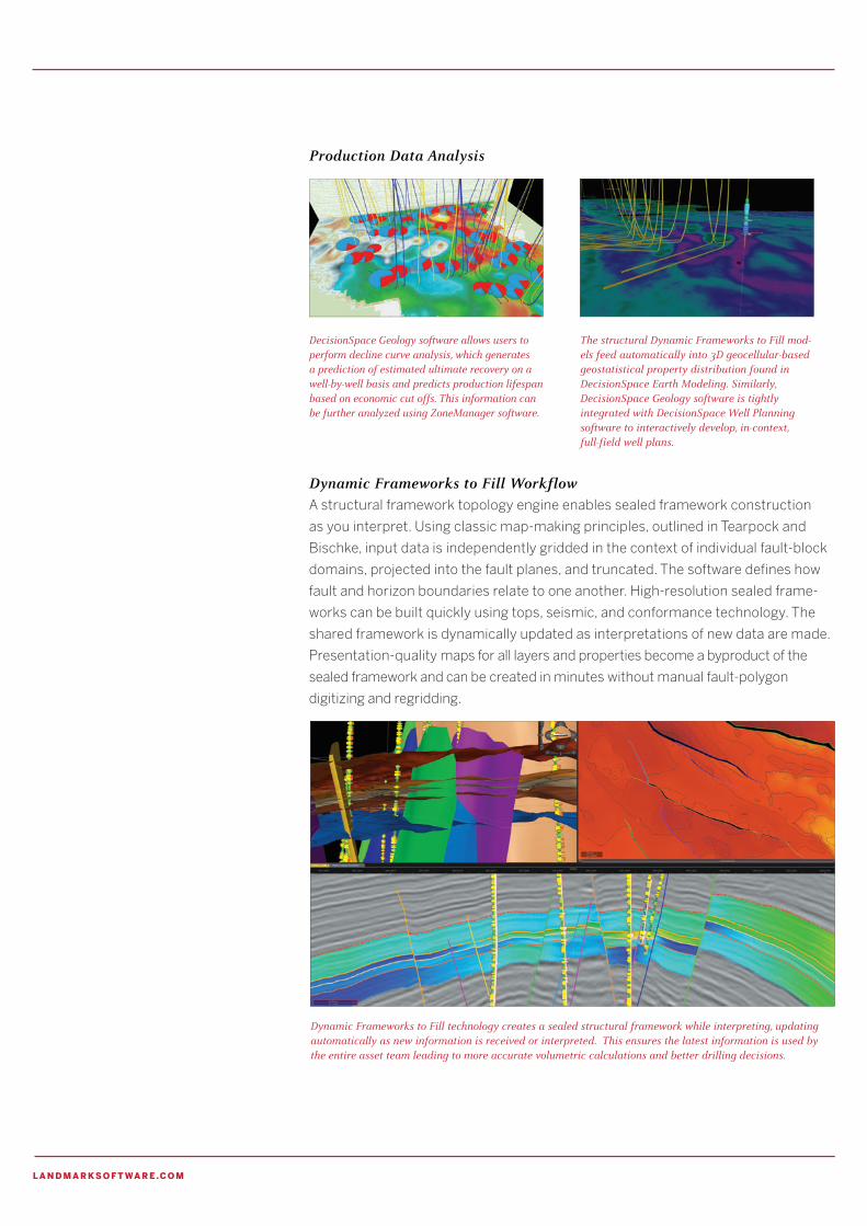
Dynamic Frameworks to Fill Workflow A structural framework topology engine enables sealed framework construction
as you interpret. Using classic map-making principles, outlined in Tearpock and
Bischke, input data is independently gridded in the context of individual fault-block
domains, projected into the fault planes, and truncated. The software defines how
fault and horizon boundaries relate to one another. High-resolution sealed frame-
works can be built quickly using tops, seismic, and conformance technology. The
shared framework is dynamically updated as interpretations of new data are made.
Presentation-quality maps for all layers and properties become a byproduct of the
sealed framework and can be created in minutes without manual fault-polygon
digitizing and regridding.
The structural Dynamic Frameworks to Fill mod-els feed automatically into 3D geocellular-based geostatistical property distribution found in DecisionSpace Earth Modeling. Similarly, DecisionSpace Geology software is tightly integrated with DecisionSpace Well Planning software to interactively develop, in-context, full-field well plans.
DecisionSpace Geology software allows users to perform decline curve analysis, which generates a prediction of estimated ultimate recovery on a well-by-well basis and predicts production lifespan based on economic cut offs. This information can be further analyzed using ZoneManager software.
Dynamic Frameworks to Fill technology creates a sealed structural framework while interpreting, updating automatically as new information is received or interpreted. This ensures the latest information is used by the entire asset team leading to more accurate volumetric calculations and better drilling decisions.

Landmark
The Dynamic Frameworks to Fill Workflow Includes:• Fault networking, unconformity trimming, and auto-generation of fault polygons
• Automatic integration of faults and unconformities
• Interactive horizon clean area and intersection editing
• Property mapping from interval and log data and use of framework
to define intervals
Fault NetworkingFault networking and modeling operations link faults and also establish a fault
hierarchy using manual and automated workflows. Fault networking seals the
framework and creates the essential fault block compartments necessary for
accurate volumetric calculations.
Conformance Mapping Implementation of this classic geologic concept uses top-down, conformable, or
bottom-up conformance techniques to speed interpretation where data is poor
or sparsely sampled. In this practical application of conformance mapping, the
software leverages the shape of seismic surfaces to guide the mapping of well-top
surfaces. Geoscientists can quickly build very high-resolution structural frame-
works by combining the horizontal resolution of seismic horizons with the very high
vertical resolution of well-log data.
Structural Modeling Tools Include: Geometry ProjectionThe Geometry Projection tool allows the creation of two essential fold styles:
parallel (true stratigraphic thickness) and similar (true vertical thickness).
Projection geometries, which are essential for extrapolating key horizons into areas
of poor data constraints, also provide information on the kind of rocks being folded
and their deformational setting.
Fault PredictionFault prediction is a useful tool for interpreting faults in areas of poor data constraint,
particularly the deeper portions that are poorly resolved. Based primarily on the
geometry of a hanging wall fold, fault prediction generates the required fault that
allows for restoration of the adjacent rocks to a balanced, pre-faulted configuration
in the section of interest. It supports flexural slip and vertical/oblique slip prediction
models to accommodate compressional or extensional settings and competent or
incompetent rock types.
Trishear ToolThe Trishear tool uses a linked fold and fault modeling algorithm where a triangular
zone of distributed deformation propagates along the fault tip. The Trishear tool can
be used to both forward model undeformed layers and to restore folded and faulted
structures. The Trishear task provides a large number of parameters that control
the type of deformation that is being modeled.
Geoscientists quickly build a sealed structural framework while they interpret, and then fill the framework with facies and deterministic reservoir properties to create accurate maps in minutes.
Visual curvature calculation in DecisionSpace Geology software.

l a n d m a r kso f t wa r e .co m
Complex Geometry Fields The Complex Geometry tool allows projection and interpolation of complicated
non-constant thickness bedding geometries, as well as analysis of the associated
bedding dip and curvature. Complex Geometry creates bedding attribute fields that
can be defined by one or more horizons, and its bedding geometry may, but need
not, conform to constant-thickness parallel or similar geometries. In addition to being
able to interpolate complex bedding shapes between more tightly constrained
horizons, the modeled dip and curvature attributes can be useful proxies for deformation
intensity and tectonic porosity/permeability distributions.
Restore ToolThe Restore tool transforms the shape of folded layers, typically to a less-deformed
or unfolded restored configuration. Comparison of the restored geometries of
hanging wall layers (above a fault) with their corresponding footwall layers (below
the fault) is a classic interpretation validation process. The available kinematic
models include flexural slip (often appropriate for deformation of competent rocks
in a compressional structure) and vertical/oblique slip (appropriate for analysis of
incompetent rocks and extensional structures).
Fault Propagation Fold and Fault Bend FoldThe Fault Propagation and Fault Bend Fold tools are used to analytically forward
model validated ramp anticline structures formed by layer-parallel flexural slip along
non-planar faults. The tools include the ability to model additional imposed shear
strains on a structure, and for interactively solving for parameters such as forelimb
thinning or thickening.
Dipmeter AnalysisThe dipmeter analysis feature provides a simple, but powerful, evaluation of well-
bore dipmeter data, including stereonet display, calculation of the statistical best-fit
fold axis and average plane orientations, and an estimate for the horizon geometry
that honors the selected dip data. The tools are particularly useful in areas of poor
data resolution. Dipmeter analysis answers questions regarding data consistency,
the best orientation to analyze the dips, and the structure of the sampled layers.
Maps are automatically created and updated as part of the Dynamic Frameworks to Fill workflow.
DecisionSpace Geology utilizes structural geology tools, such as shear strain and fault propagation, to guide geoscientists to a more accurate subsurface interpretation.

Landmark
system and software
software requirements
OpenWorks 5000.8.3.0
DecisionSpace Base module
DecisionSpace GIS module
to run GIS workflows
operating systems
Red Hat® Enterprise Linux®
Workstation 5.3, 64 bit
Windows® 7, 64 bit
Next Generation MappingDynamic Frameworks to Fill software technology enables and streamlines the inter-
preter’s ability to develop prospects within highly complex structural and strati-
graphic plays. Topology tools and conformance technology produce robust, high-
quality frameworks and maps. Structural mapping as an integral part of framework
construction ensures internal consistency across multiple mapping layers, and
forms the basis for property mapping. The ability to map zone-based, log-derived
properties and to automate the updating of structure and property maps as data
are added or edited, significantly improves mapping efficiency.
VolumetricsDecisionSpace Geology software provides gross rock volume calculations leveraging
the Dynamic Frameworks to Fill workflow to easily define and update the container
for mapping fluid contacts, basic spill point, and hydrocarbon pore volumes within
specific reservoir compartments—including depth/area and depth/volume plots.
The software streamlines analysis of what-if scenarios.
Horizontal Well CorrelationThe Horizontal Well Correlation add-on component assists geoscientists in
correlating logging-while-drilling data from the horizontal portion of a well to data in
the vertical portion of the well or nearby offset wells. The software uses horizontal
well correlations to help determine the stratigraphic position of the wellbore, and
in turn automate updates to the target-formation map. This technology integrated
with real-time data, Dynamic Frameworks to Fill mapping technology, and advanced
well-path planning capabilities enabled by the unified DecisionSpace environment,
delivers unique “look-ahead” well planning and geosteering workflows. The ability to
steer the drill bit through the most productive zones in the target formation is one
of the critical operations affecting the financial success of shale and other plays.
Horizontal Well Correlation software helps geoscientists determine the stratigraphic position of the wellbore in horizontal wells and supports powerful geosteering workflows in the DecisionSpace environment.

l a n d m a r kso f t wa r e .co m
Landmark offers solutions to help you deliver on your business strategies. For questions or to contact your Landmark representative, visit us at landmarksoftware.com.
Landmark
Sales of Halliburton products and services will be in accord solely with the terms and conditions contained in the contract between Halliburton and the customer that is applicable to the sale. H010646 © 2015 Halliburton. All Rights Reserved.
“Having structural interpretation and framework modeling in the same system is much better than separate applications.”geologist