Embed Size (px)
Citation preview

DEM Licensing & Land Development RFP Project – Use Case Number – CP01
Department Name: Comprehensive Planning Process Name: Street Address Maintenance Use Case Number: CP01 Use Case Name: Create and Update Address Created By: Greg Cerven, Dave Brown, and Karthik Chandran Level: User Goal Description: Create and update addresses within the unincorporated Clark County. Primary Actor: Planner, Zoning Plans Checker Other Stakeholders: Customer (E.g. Developer, Owner, Federal, School Districts), Building Permit Zoning Plans Checkers Pre-condition: Parcel number needs to exist for the address. Post-condition: User is able to create or update an address. Trigger:
1. Receive a building permit or a map record from customer to create an address. Receive an address change application to update an address.
2. Receive a letter from Federal or School district to create or update an address.
Related Use Case(s): Primary Actor System
Main Path: Create Main Address Rate
1. User logs in to the Land Management System and navigates to the Create Address screen.
2. User selects the address view. 3. User enters the parcel number for the
main address and selects to search. 4. System retrieves the parcel.
5. User selects to enter a main address for the parcel.
6. System displays the Address Maintenance screen.
7. User enters the following, - Address Information - Address Other Information
8. System displays the Zoning Code Maintenance Screen.
9. User enters the Zoning Code Information. 10. System displays the Address Miscellaneous Maintenance screen.
11. User enters the Address Miscellaneous Information and selects to save.
12. System creates a new main address with a new location ID.
Alternate Path 1: Create Secondary Address 1.1 (At Step 2) User selects the parcel view. 1.2 User enters the parcel number for the
main address and selects to search. 1.3 System retrieves the parcel.
1.4 User selects to view Miscellaneous Information for the parcel.
1.5 System retrieves the miscellaneous information for the parcel.
1.6 User copies the Location ID for the parcel.
1.7 User switches to the Location ID view. 1.8 User enters the copied parcel Location ID
and selects to search. 1.9 System retrieves the location.
1.10 User selects to copy the location. 1.11 System displays the Address Maintenance screen.
4/15/2013 1 of 4

DEM Licensing & Land Development RFP Project – Use Case Number – CP01
1.12 User enters the following information, - Address Information - Address Other Information
1.13 System displays the Zoning Code Maintenance Screen.
1.14 User enters the Zoning Code Information. 1.15 System displays the Address Miscellaneous Maintenance screen.
1.16 User enters the Address Miscellaneous Information and selects to save.
1.17 System creates a new secondary address with a new location ID and links it to the parcel location ID.
Alternate Path 2: Update Address (Main/Secondary)
2.1 (At Step 3) User enters the parcel number for the address (main/secondary) and selects to search.
2.2 System retrieves the parcel.
2.3 User selects to update the address. 2.4 System displays the Address Maintenance screen.
2.5 User updates the following, - Address Information - Address Other Information
2.6 System displays the Zoning Code Maintenance Screen.
2.7 User updates the Zoning Code Information.
2.8 System displays the Address Miscellaneous Maintenance screen.
2.9 User updates the Address Miscellaneous Information, adds the following comments and selects to save. - Enter the old address/initials under
the code PA (Previous Address). - Enter the new address/initials under
the code NA (New Address). - Enter the reason for change and
reference the Address Change Application Number/initials under the code AD (Address Note).
2.10 System saves the updates for the address.
Business Rules: BR-1 (At Step 12, 1.17): One address will be associated with only one location ID. BR-2 (At Step 12): Parcel number will be used to create the main address. BR-3 (At Step 1.17): Location ID will be used to create the secondary address. BR-4 (At Step 2.10): System must maintain the historical data and related audit data. BR-5 (At Step 12, 1.17): One parcel can be associated with multiple location ID’s. Design: Address (Main/Secondary) Information: (At Step 7, 1.12, 2.5)
1. Location ID - System assigned unique ID for the address. 2. Number - Street number 3. Street Name - Name of the street 4. Suffix - Street Suffix 5. Direction - Street direction 6. Pre Qualifier - Common lot number 7. Post Qualifier - Apartment number or Unit number 8. Post Direction - Indicates direction from the beltway 9. Apartment - Apartment number
4/15/2013 2 of 4

DEM Licensing & Land Development RFP Project – Use Case Number – CP01
10. Extended Address - Not used 11. Zip Code - Zip code for the address 12. Delivery Point - 13. Address Type - System should be able to identify main and secondary addresses.
Currently they are identified with a “(M)” and “(*)”. Address Other Information: (At Step 7, 1.12, 2.5)
1. Assessor Parcel Number - Parcel number for the address. 2. Tax District - Tax district number 3. Inside Outside Code - 4. General Location Code - 5. Range-Township-Section - Range, township and section number 6. Effective Date - 7. Status - Active or inactive 8. Carrier Route - 9. Intersection Direction - Intersection street direction 10. Intersection Name - Intersection street name 11. Intersection Suffix - Intersection street suffix
Zoning Code Information: (At Step 9, 1.14, 2.7) 1. Location ID - System assigned unique ID for the address. 2. Subdivision Codes - Book/Page/Subdivision number 3. Commissioner District- Code for the commissioner district 4. Property Use - Property use number 5. Variance Code - 6. Inspection Area - Code based on the township. If the parcel exists then the
inspection area code also exists. 7. Use Zone - Code for the use zone 8. Fire Zone - 9. Undivided Interest Percentage - 10. Plat Book/Page Number - 11. Acreage - 12. Longitude - 13. Latitude - 14. Census Tract - 15. Map Number x/y -
Address Miscellaneous Information: (At Step 11, 1.16, 2.9)
1. Location ID - System assigned unique ID for the address. 2. Subdivision - Subdivision 3. Assessor Parcel Number - Assessor Parcel Number 4. Range-Township-Section - Range-Township-Section 5. Location Address - Location Address 6. Primary Related Party - Primary Related Party 7. Code - User defined codes. E.g. PA-Previous Address,
NA-New Address, AD-Address Note. 8. App - Application Code. E.g. BP (Building Permits), LM
(Location Maintenance) 9. Date - 10. Comments - Notes can include the type and purpose of address.
Any miscellaneous note such as the address was 4/15/2013 3 of 4

DEM Licensing & Land Development RFP Project – Use Case Number – CP01
transferred from one parcel to another. Building department plan checkers will review these notes.
Search Criteria: 1. Parcel Number - Assessor parcel number. 2. Location ID - Unique ID for a location.
Security Requirement(s): Data Retention: Comments:
1. Other departments (E.g. Building) view and enter address comments.
4/15/2013 4 of 4

DEM Licensing & Land Development RFP Project – Use Case Number – CP02
Department Name: Comprehensive Planning
Process Name: Street Address Maintenance
Use Case Number: CP02
Use Case Name: Create Multiple Addresses
Created By: Greg Cerven and Karthik Chandran
Level: User Goal
Description: Create multiple addresses for multiple parcels within the unincorporated Clark County.
Primary Actor: Planner
Other Stakeholders: Assessor’s Office, Customer (E.g. Developer, Owner, Federal, School Districts)
Pre-condition: Parcel number does not exist for the addresses.
Post-condition: User is able to create multiple addresses for multiple parcels.
Trigger: Receive a recorded map from a developer to create multiple addresses for multiple parcels.
Related Use Case(s):
Primary Actor System
Main Path: Rate
1. User logs in to the Land Management System and navigates to the Multiple Address screen.
2. System displays the Multiple Address screen.
3. User enters Mass Location Information.
4. System displays the Default Miscellaneous Information screen.
5. User enters Default Miscellaneous Information.
6. System displays the Default User Defined Codes screen.
7. User enters Default User Defined Codes Information which includes the legal description.
8. System displays the Address/Parcel screen.
4/15/2013 1 of 5
DEM Licensing & Land Development RFP Project – Use Case Number – CP02
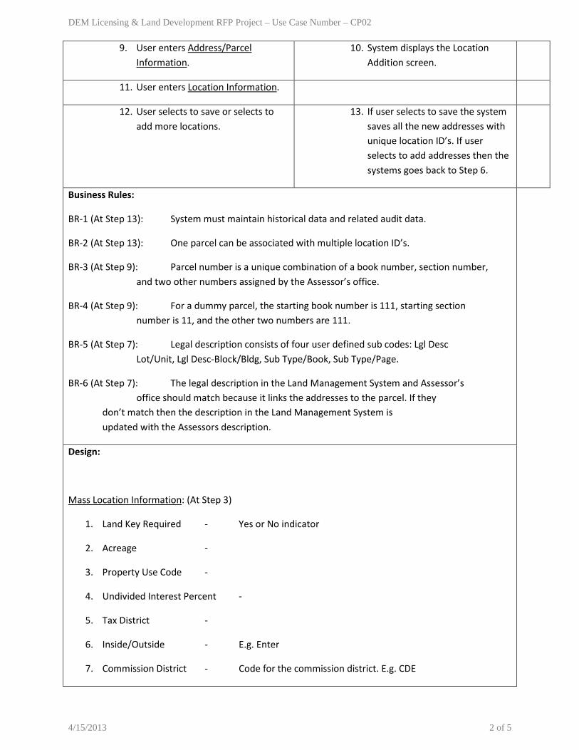
9. User enters Address/Parcel Information.
10. System displays the Location Addition screen.
11. User enters Location Information.
12. User selects to save or selects to add more locations.
13. If user selects to save the system saves all the new addresses with unique location ID’s. If user selects to add addresses then the systems goes back to Step 6.
Business Rules:
BR-1 (At Step 13): System must maintain historical data and related audit data.
BR-2 (At Step 13): One parcel can be associated with multiple location ID’s.
BR-3 (At Step 9): Parcel number is a unique combination of a book number, section number, and two other numbers assigned by the Assessor’s office.
BR-4 (At Step 9): For a dummy parcel, the starting book number is 111, starting section number is 11, and the other two numbers are 111.
BR-5 (At Step 7): Legal description consists of four user defined sub codes: Lgl Desc Lot/Unit, Lgl Desc-Block/Bldg, Sub Type/Book, Sub Type/Page.
BR-6 (At Step 7): The legal description in the Land Management System and Assessor’s office should match because it links the addresses to the parcel. If they don’t match then the description in the Land Management System is updated with the Assessors description.
Design:
Mass Location Information: (At Step 3)
1. Land Key Required - Yes or No indicator
2. Acreage -
3. Property Use Code -
4. Undivided Interest Percent -
5. Tax District -
6. Inside/Outside - E.g. Enter
7. Commission District - Code for the commission district. E.g. CDE
4/15/2013 2 of 5

DEM Licensing & Land Development RFP Project – Use Case Number – CP02
8. X and Y Coordinates -
9. Effective Date -
10. Address Status - Active or Inactive
Default Miscellaneous Information: (At Step 5)
1. Code - E.g. AD
2. App - Application Code. E.g. BP
3. Freeform Information - Text/Comments
4. Date - Date for the comments.
5. Notes - Text/Comments
6. Parcel Code - Checkbox to indicate if it is a parcel code or not.
Default User Defined Codes Information: (At Step 7)
1. Sub Code - User defined codes (L-Lot, U-Unit, B-Block, G-Building, PB-Plat Book etc.). It contains the legal description.
2. Description - Description of the sub code.
3. Number -
4. Text - Value of the sub code.
5. Date -
Address/Parcel Information: (At Step 9)
1. Direction - Direction of the street
2. Name - Name of the street
3. Suffix - Suffix for the street
4. Post Direction - Indicates direction from the beltway
5. Protect Direction/Name - Indicates if direction/name is protected.
6. Starting Street Number - First street number
7. Increment Street Number By - Street number increments
4/15/2013 3 of 5

DEM Licensing & Land Development RFP Project – Use Case Number – CP02
8. Location Zip Code - Zip code of the location
9. Starting Book - Book number
10. Starting Sect - Section number
11. Starting Page - Number assigned by Assessor’s office.
12. Starting Numb - Number assigned by Assessor’s office.
13. Starting Book Protect - Indicates if book number is protected.
14. Starting Sect Protect - Indicates if section number is protected.
15. Starting Page Protect - Indicates if page number is protected.
16. Starting Numb Protect - Indicates if starting number is protected.
Location Information: (At Step 11)
1. Direction - Direction of the street
2. Name - Name of the street
3. Suffix - Suffix for the street
4. Post Direction - Indicates direction from the beltway
5. Number - Street number
6. Pre Qualifier - Common lot number
7. Post Qualifier - Apartment number or Unit number
8. Apartment - Apartment number
9. Book - Book number.
10. Sect - Section number.
11. Page - Number assigned by Assessor’s office.
12. Numb - Number assigned by Assessor’s office.
13. Sub Division Codes - Book and page number
14. Range-Township-Section - Range, township and section number
15. Location Alias -
16. Plat Book/Page Number -
4/15/2013 4 of 5

DEM Licensing & Land Development RFP Project – Use Case Number – CP02
17. Fire Zone Code -
18. Use Zoning Code -
19. Inspection Area Code - Code based on the township. If the parcel exists then the inspection area code also exists.
20. Zoning Variance Code -
21. Census Tract -
22. Latitude -
23. Longitude -
Search Criteria:
Security Requirement(s):
Data Retention:
Comments:
1. A dummy parcel is created in the Land Management System as the Assessor’s office may take around a month to create a parcel.
2. A vacant parcel has no address.
4/15/2013 5 of 5

DEM Licensing & Land Development RFP Project – Use Case Number – CP03
Department Name: Comprehensive Planning Process Name: Street Address Maintenance Use Case Number: CP03 Use Case Name: Maintain Street Dictionary Created By: Greg Cerven and Karthik Chandran Level: User Goal Description: Create and update street names within the unincorporated Clark County. Primary Actor: Planner Other Stakeholders: Customer (E.g. Developer, Owner, Federal, School Districts) Pre-condition: NA Post-condition: User is able to create a new street name and update it. Trigger: Receive a map or street name change application from the customer to create or update street name. Related Use Case(s):
Primary Actor System Main Path: Create street address Rate
1. User logs in to the Land Management System and navigates to the Maintain Street Dictionary screen.
2. User enters the Street Dictionary Information and selects to save.
3. System creates a new street address.
Alternate Path 1: Update street address 1.1 (At Step 2) User enters an existing street
address and selects to search. 1.2 System displays a list of matching street
addresses.
1.3 User selects the required street address. 1.4 System displays the street address information.
1.5 User updates the Street Dictionary Information and selects to save.
1.6 System saves the updated street address information.
Business Rules: BR-1 (At Step 1.6): System must maintain historical data and related audit data. Design: Application Forms:
1. Street name change application
Street Dictionary Information: (At Step 2, 1.5) 1. Street Name - Name of the street 2. Street Direction Code - Code for the street direction 3. Street Suffix - Suffix for the street 4. Post Street Direction - Indicates direction from the beltway 5. Lower Limit Number - Not used 6. Upper Limit Number - Not used 7. Zip Code - 8. Tax District - 9. Inside Outside Code - 10. Street Cross Reference - 11. Even/Odd Flag -
4/15/2013 1 of 2

DEM Licensing & Land Development RFP Project – Use Case Number – CP03
12. Public or Private - 13. Latitude Range - 14. Longitude Range - 15. Census Tract Range - 16. Street Entry Status - Active or Inactive
Search Criteria:
1. Street Address - Street number, street name, city. Security Requirement(s): Data Retention: Comments:
4/15/2013 2 of 2

DEM Licensing & Land Development RFP Project – Use Case Number – CP04
Department Name: Comprehensive Planning Process Name: Street Address Maintenance Use Case Number: CP04 Use Case Name: Maintain Subdivision Codes Created By: Greg Cerven and Karthik Chandran Level: User Goal Description: Create and update subdivision codes within the unincorporated Clark County. Primary Actor: Planner Other Stakeholders: Customer (E.g. Developer, Owner) Pre-condition: NA Post-condition: User is able to create a new subdivision code and update it. Trigger: Receive a recorded map from the developer to create or update subdivision code. Related Use Case(s):
Primary Actor System Main Path: Create subdivision Rate
1. User logs in to the Land Management System and navigates to the Maintain Subdivision Codes screen.
2. User selects to add a new subdivision. 3. System displays the Subdivision Description Maintenance screen.
4. User enters the Subdivision Description Information.
5. System displays the Subdivision Miscellaneous Information Maintenance screen.
6. User enters the Subdivision Miscellaneous Information and selects to save.
7. System creates a new subdivision.
Alternate Path 1: Update subdivision 1.1 (At Step 2) User selects an existing
subdivision. 1.2 System displays the Subdivision
Description Maintenance screen.
1.3 User updates the Subdivision Description Information.
1.4 System displays the Subdivision Miscellaneous Information Maintenance screen.
1.5 User updates the Subdivision Miscellaneous Information and selects to save.
1.6 System saves the updated subdivision information.
Business Rules: BR-1 (At Step 7): Subdivision code is based on the book number and page number. BR-2 (At Step 1.6): System must maintain historical data and related audit data. Design: Subdivision Description Information: (At Step 4, 1.3)
1. Subdivision Code 1 - Book Number 2. Subdivision Code 2 - Page Number 3. Subdivision Description - Subdivision Description/Map Name
Subdivision Miscellaneous Information: (At Step 6, 1.5)
4/15/2013 1 of 2

DEM Licensing & Land Development RFP Project – Use Case Number – CP04
1. Code - “SBDV” 2. Application - “BP” 3. Date - Comment date 4. Note - Text/Comments. It can include the final map number,
tenant map number, related land use application number, zone and number of lots.
Search Criteria: Security Requirement(s): Data Retention: Comments:
4/15/2013 2 of 2

DEM Licensing & Land Development RFP Project – Use Case Number – CP05
Department Name: Comprehensive Planning Process Name: Street Address Maintenance Use Case Number: CP05 Use Case Name: Transfer Building Permit Address Created By: Greg Cerven, Dave Brown, and Karthik Chandran Level: User Goal Description: Transfer the building permit number to a new address/parcel. Primary Actor: Senior Planner, Zoning Plans Checker Other Stakeholders: Customer (E.g. Developer, Owner, Federal, School Districts), Building Department Plan Checkers Pre-condition: Customer makes an appointment with the planner to discuss the building permit transfer associated with an address change application. Post-condition: User is able to transfer the building permit number to a new address/parcel. Trigger: Receive an address change application from the customer that has an associated building permit number. Related Use Case(s):
Primary Actor System Main Path: Transfer Building Permit Address Rate
1. User logs in to the Land Management System and navigates to the Transfer Building Permit Address screen.
2. User enters the Search Criteria and selects to search for an application.
3. System displays the search results.
4. User selects the address change application.
5. System displays the application information.
6. User selects to transfer the address for the building permit in the application.
7. System displays Transfer Building Permit Address information.
8. User enters the new address/parcel to which the building permit number will be transferred.
9. System displays the transfer confirmation screen with from and to addresses, parcels, and owners.
10. User reviews the information and selects to save.
11. System transfers the building permit number to the new address/parcel.
Business Rules: BR-1 (At Step 5): For condominiums, the application needs to be setup on the "000" parcel number associated with the address change. BR-2 (At Step 5): If an address has more than one parcel then the application should be attached to the lowest parcel number or the parcel number that is most appropriate. BR-3 (At Step 11): System must maintain historical data and related audit data. Design: Transfer Building Permit Address: (At Step 7)
1. Application Number - Address change application number. 2. From Parcel Number - Current Assessor’s Parcel Number. 3. From Address - Current property address. 4. From Owner - Current owner name. 5. To Parcel Number - Future Assessor’s Parcel Number. 6. To Address - Future property address.
4/15/2013 1 of 2

DEM Licensing & Land Development RFP Project – Use Case Number – CP05
7. To Owner - Future owner name. Search Criteria:
Search Criteria: (At Step 2) 1. Assessor’s Parcel Number 2. Project Number 3. Application Number 4. Application Type 5. Application Status
Security Requirement(s): Data Retention: Comments:
4/15/2013 2 of 2

DEM Licensing & Land Development RFP Project – Use Case Number – CP06
Department Name: Comprehensive Planning Process Name: Street Address Maintenance Use Case Number: CP06 Use Case Name: Review Assessor’s Report 6132 Created By: Greg Cerven and Karthik Chandran Level: User Goal Description: Review and cross check address information in Assessor’s Report 6132 and the Land Management System. Primary Actor: Planner Other Stakeholders: Assessor’s Office Pre-condition: NA Post-condition: User is able to review and cross check address information in the assessor’s report and the Land Management System. Trigger: Receive Report 6132 from the Assessor’s office. Related Use Case(s):
Primary Actor System Main Path: Verify address Rate
1. User logs in to the Land Management System and navigates to the Review Assessor’s Report 6132 screen.
2. User enters the parcel number for the address in Report 6132 and selects to search.
3. System retrieves the parcel.
4. User selects to review the address information.
5. System checks if address matches in the report and the Land Management System. Then it displays the Address Miscellaneous Information indicating any discrepancies found.
6. User checks if the address is assigned properly and the notes are correct in the Land Management System.
Business Rules: Design: Address Miscellaneous Information: (Step 5)
1. Location ID - Location ID 2. Subdivision - Subdivision 3. Assessor Parcel Number - Assessor Parcel Number 4. Range-Township-Section - Range-Township-Section 5. Location Address - Location Address 6. Primary Related Party - Primary Related Party 7. Code - User defined codes. E.g. PA (Previous Address),
NA (New Address), AD (Address Note) - Reason for approval or denial.
8. App - Application Code. E.g. BP 9. Date - Note entry date. 10. Text - Notes/Comments. All application numbers
associated with the parcel should be listed. It can
4/15/2013 1 of 2

DEM Licensing & Land Development RFP Project – Use Case Number – CP06
include the type and purpose of address. Any miscellaneous note such as the address was transferred from one parcel to another. Building department plan checkers will review these notes.
Search Criteria: 1. Parcel Number - Assessor Parcel Number
Security Requirement(s): Data Retention: Comments:
1. After checking in the Land Management System user checks if the addresses are proper in Open Door.
4/15/2013 2 of 2

DEM Licensing & Land Development RFP Project – Use Case Number – CP07
Department Name: Comprehensive Planning Process Name: Street Address Maintenance Use Case Number: CP07 Use Case Name: Review Assessor’s Report 5332 Created By: Greg Cerven and Karthik Chandran Level: User Goal Description: Review and cross check legal description in Assessor’s Report 5332 and the Land Management System. Primary Actor: Planner Other Stakeholders: Assessor’s Office Pre-condition: NA Post-condition: User is able to review and cross check legal description in the assessor’s report and the Land Management System. Trigger: Receive Report 5332 from the Assessor’s office. Related Use Case(s):
Primary Actor System Main Path: Verify Legal Description Rate
1. User logs in to the Land Management System and navigates to the Review Assessor’s Report 6132 screen.
2. User enters the address in report 5332 and selects to search.
3. System retrieves the address.
4. User selects to review the legal description for the address.
5. System checks if the legal description matches in the report and the Land Management System. Then it displays the Address User Defined Codes indicating any discrepancies found.
6. User checks if the legal description in the report 5332 matches with the Land Management System.
Business Rules: BR-1 (At Step 6): Legal description consists of four user defined sub codes: Lgl Desc Lot/Unit, Lgl Desc-Block/Bldg, Sub Type/Book, Sub Type/Page. Design: Address User Defined Codes: (At Step 5)
1. Location ID - System assigned unique ID for the address. 2. Assessor Parcel Number - Parcel number for the address. 3. Range-Township-Section - Range, township and section number. 4. Location Address - Address. 5. Primary Related Party - Address contact person. 6. Sub Code - User defined codes (L-Lot, U-Unit, B-Block, G-
Building, PB-Plat Book etc.) 7. Description - Description of the sub code 8. Number - 9. Text - Value of the sub code 10. Date -
Search Criteria:
4/15/2013 1 of 2

DEM Licensing & Land Development RFP Project – Use Case Number – CP07
1. Address - Street Number, Street Name, City
Security Requirement(s): Data Retention: Comments:
4/15/2013 2 of 2

DEM Licensing & Land Development RFP Project – Use Case Number – CP08
Department Name: Comprehensive Planning Process Name: Street Address Maintenance Use Case Number: CP08 Use Case Name: Review Assessor’s Report 5337 Created By: Greg Cerven and Karthik Chandran Level: User Goal Description: Verify if the “From Parcel” and “To Parcel” activity matches in Assessor’s Report 5337 and the Land Management System. If the “From Parcel” activity does not match then add “From Parcel” activity in the Land Management System. Primary Actor: Planner/ Other Stakeholders: Assessor’s Office Pre-condition: NA Post-condition: User is able to match the “From Parcel” and “To Parcel” activity in the report and Land Management System. If the “From Parcel” activity does not match, user adds it in the Land Management System. Trigger: Receive Report 5337 from the Assessor’s office. Related Use Case(s): CP01 - Create and Update Address CP05 - Transfer Building Permit Address
Primary Actor System Main Path: Verify From and To Parcel activity
Rate
1. User logs in to the Land Management System and navigates to the Review Assessor’s Report 5337 screen.
2. User enters the parcel number for the address in Report 5337and selects to search.
3. System retrieves the parcel.
4. User selects to review parcel activity. 5. System checks if the From and To Parcels match in the report and the Land Management System. Then it displays the From and To Parcel Activity Information indicating any discrepancies found.
6. User verifies that the From Parcel Activity Information and To Parcel Activity Information in the Land Management System match with Report 5337.
Alternate Path 1: “From Parcel” activity does not match
1.1 (At Step 6) The “From Parcel” activity in the Land Management System does not match with Report 5337.
1.2 User selects to add parcel activity. 1.3 System displays the From Parcel Activity Maintenance screen.
1.4 User enters the From Parcel Activity 1.5 System saves the “From Parcel” activity
4/15/2013 1 of 2
DEM Licensing & Land Development RFP Project – Use Case Number – CP08
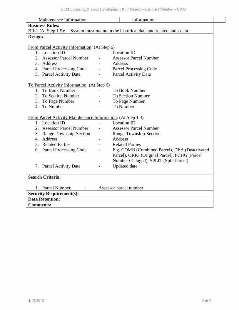
Maintenance Information. information. Business Rules: BR-1 (At Step 1.5): System must maintain the historical data and related audit data. Design: From Parcel Activity Information: (At Step 6)
1. Location ID - Location ID 2. Assessor Parcel Number - Assessor Parcel Number 3. Address - Address 4. Parcel Processing Code - Parcel Processing Code 5. Parcel Activity Date - Parcel Activity Date
To Parcel Activity Information: (At Step 6)
1. To Book Number - To Book Number 2. To Section Number - To Section Number 3. To Page Number - To Page Number 4. To Number - To Number
From Parcel Activity Maintenance Information: (At Step 1.4)
1. Location ID - Location ID 2. Assessor Parcel Number - Assessor Parcel Number 3. Range-Township-Section - Range-Township-Section 4. Address - Address 5. Related Parties - Related Parties 6. Parcel Processing Code - E.g. COMB (Combined Parcel), DEA (Deactivated
Parcel), ORIG (Original Parcel), PCHG (Parcel Number Changed), SPLIT (Split Parcel)
7. Parcel Activity Date - Updated date Search Criteria:
1. Parcel Number - Assessor parcel number Security Requirement(s): Data Retention: Comments:
4/15/2013 2 of 2

DEM Licensing & Land Development RFP Project – Use Case Number – CP09
Department Name: Comprehensive Planning Process Name: Street Address Maintenance Use Case Number: CP09 Use Case Name: Review Assessor’s Conversion Report Created By: Greg Cerven and Karthik Chandran Level: User Goal Description: Verify if “To Parcel” activity matches in the Assessor’s Conversion Report and the Land Management System, so that the addresses are transferred correctly. If the activity matches then change the inactive parcel to the new parcel for all the addresses. Primary Actor: Planner Other Stakeholders: Assessor’s Office Pre-condition: NA Post-condition: User is able to match “To Parcel” activity in the Land Management System and the conversion report. If the activity matches then user is able to update the address from the inactive parcel to the new parcel (the parcels could have been subdivided or merged). Trigger: Receive Conversion Report from the Assessor’s office. Related Use Case(s):
Primary Actor System Main Path: Verify “To Parcel” activity Rate
1. User logs in to the Land Management System and navigates to the Review Assessor’s Conversion Report screen.
2. User enters the parcel number for an address in the Conversion Report and selects to search.
3. System retrieves the parcel.
4. User selects to review the parcel activity. 5. System checks if the To Parcel matches in the report and the Land Management System. Then it displays the To Parcel Activity Information indicating any discrepancies found.
6. User verifies that the To Parcel Activity Information in the Land Management System matches with the Conversion Report.
Alternate Path 1: Change inactive parcel 1.1 (At Step 6) If the “To Parcel” activity
matches in the report and the Land Management System.
1.2 User enters the address for the parcel and selects to search.
1.3 System retrieves the address.
1.4 User selects to view miscellaneous information for the address.
1.5 System displays the miscellaneous address information screen.
1.6 User changes the inactive parcel to the active parcel for the address and selects to save.
1.7 System saves the active parcel for the address.
Business Rules:
4/15/2013 1 of 2

DEM Licensing & Land Development RFP Project – Use Case Number – CP09
BR-1 (At Step 1.7): System must maintain the historical data and related audit data. Design: To Parcel Activity Information: (At Step 6)
1. To Book Number - To Book Number 2. To Section Number - To Section Number 3. To Page Number - To Page Number 4. To Map Number - To Map Number
Search Criteria:
1. Parcel Number - Assessor parcel number 2. Address - Street number, street name, city
Security Requirement(s): Data Retention: Comments:
4/15/2013 2 of 2

DEM Licensing & Land Development RFP Project – Use Case Number – CP10
Department Name: Comprehensive Planning Process Name: Street Address Maintenance Use Case Number: CP10 Use Case Name: Create Address Report Created By: Greg Cerven and Karthik Chandran Level: User Goal Description: Create a report for addresses within the unincorporated Clark County. Primary Actor: Planner Other Stakeholders: Customer (E.g. Developer, Owner, Federal, School Districts) Pre-condition: The addresses must exist in the system. Post-condition: User is able to create a report of addresses and save it in various formats. Trigger: Receive a recorded map from a customer to create addresses. Related Use Case(s):
Primary Actor System Main Path: Create address report Rate
1. User logs in to the Land Management System and navigates to the address report screen.
2. User enters the search/filter criteria for the report and selects to run.
3. System creates a report for the requested addresses.
4. User reviews the Report Header, Report Body and saves the report (CSV, Word, Excel or PDF formats).
Business Rules: BR-1 (At Step 2) - For a map, the book number and page number combination is unique. BR-2 (At Step 3) - In the address report, the system should not display old lots and addresses in a recorded map. Design: Report Header: (At Step 4)
1. Subdivision Name - From the Land Management System 2. Recording Date - Noted Manually 3. Book/Page Number - From the Land Management System 4. Final Map Number - Tracking Number. From the Land Management System. 5. Fire Map Number - Not in the Land Management System 6. Town Board - From the Land Management System 7. Major Project - From Open Door 8. Commission District - From the Land Management System 9. Section/Township/Range - From the Land Management System 10. Prepared By - User name 11. Date Prepared - Report date 12. Notes - Miscellaneous text
Report Body: (At Step 4)
1. Block Number - Used for single family. 2. Building Number - Used for condominium. 3. Lot Number - Used for single family.
4/15/2013 1 of 2

DEM Licensing & Land Development RFP Project – Use Case Number – CP10
4. Unit Number - Used for condominium. 5. Address - Street number 6. Direction - Street direction 7. Recorded Street Name- Street Name 8. Unit Number - Apartment/Unit number
Search/Filter Criteria: 1. Book Number 2. Page Number 3. Subdivision Name
Security Requirement(s): Data Retention: Comments:
4/15/2013 2 of 2

DEM Licensing & Land Development RFP Project – Use Case Number – CP11
Department Name: Comprehensive Planning Process Name: Tracking Applications, Street Address Maintenance Use Case Number: CP11 Use Case Name: View Application and Map Submittal Information Created By: Phil Blount and Karthik Chandran Level: User Goal Description: View submittal requirements (forms, checklists, fees, deadlines etc.) for Clark County Comprehensive Planning Department applications (E.g. Land use/zoning, administrative) or maps. Primary Actor: Customer Other Stakeholders: NA Pre-condition: NA Post-condition: User is able to view submittal information for various Comprehensive Planning applications/maps. Trigger: Customer needs to view submittal information. Related Use Case(s): NA
Primary Actor System Main Path: View application/map requirements
Rate
1. User logs in to the Land Management System and navigates to the Application/Map Requirements screen.
2. System displays all the Comprehensive Planning applications.
3. User selects to view submittal information for an application/map.
4. System displays the application, related documents and submittal requirements (checklists, fees, deadlines etc.).
Business Rules: Design: Zoning Applications/Forms:
1. Land Use Application 2. Administrative Application 3. Administrative Temporary Use Application 4. Land Use Pre-submittal & Plan Amendment Application 5. Tentative Map Application 6. Vacation Application 7. HIP/RISE/Non-Conforming Zone Change Reports Filing 8. Major Projects - Concept Plan Application 9. Major Projects - Development Agreement Application 10. Major Projects - Entitlement Application 11. Major Projects - Specific Plan Application 12. Major Projects - Temporary Outdoor Commercial/Promotional Activity/Event
Application 13. Major Projects - Title 29 Land Use Application 14. Major Projects - Title 29/30 Administrative Application 15. Major Projects - Title 30 Land Use Application 16. Major Projects - Waiver of Title 27/28 Application 17. Major Projects - Administrative Waiver of Title 27/28 Application 18. Major Projects - Tentative Map Checklist 19. Address Change Request Form
4/15/2013 1 of 2

DEM Licensing & Land Development RFP Project – Use Case Number – CP11
20. Zoning Letter and Research Request Form 21. Appeal Form 22. BLM Land Sale Request Form 23. Communication Tower Removal Bond 24. Disclosure Form 25. Ownership Disclosure Form 26. Early Building Number Request Form 27. Homeowner/Neighborhood Association Notification Registration Form 28. Public Records Request Form 29. Title 30 Subscription Order Form 30. Vacation Attachment "Exhibit A" 31. Water Feature/Turf Reduction Worksheet 32. Administrative Minor Deviation Checklist 33. Commercial/Industrial Development Checklist 34. Communication Towers & Antennas Checklist 35. Residential Development Checklist 36. Tentative Map Checklist 37. Filing Deadlines 38. Non-Conforming Zone Change Schedule 39. Pre-Submittal Conference Schedule 40. Filing Fees 41. Major Projects Filing Fees 42. Submittal Requirements
Maps:
1. Tenant Map 2. Final Map 3. Map Check Map 4. Recorded Map
Search Criteria: Security Requirement(s): Data Retention: Comments:
4/15/2013 2 of 2
DEM Licensing & Land Development RFP Project – Use Case Number – CP12
Department Name: Comprehensive Planning Process Name: Tracking Applications, Street Address Maintenance Use Case Number: CP12 Use Case Name: Submit and Update Application, Maps and Plans Created By: Phil Blount and Karthik Chandran Level: User Goal Description: Submit and update online Comprehensive Planning Department applications (E.g. land use/zoning, administrative), maps, plans and documents for review and approval. Primary Actor: Customer Other Stakeholders: NA Pre-condition: Application is available online for user submission. Post-condition: User is able to submit and update electronic application, maps and plans online to the Comprehensive Planning Department. Trigger: Customer needs the application, maps and plans approved. Related Use Case(s): NA
Primary Actor System Main Path: Submit Application/Maps/Plans/Documents
Rate
1. User logs in to the Web Portal of the Land Management System and navigates to the Submit Application screen.
2. User enters the relevant Application Information.
3. System displays the Maps/Plans Attachment screen.
4. User selects and attaches the maps/plans/other required documents and selects to save.
5. System assigns a unique identifier for the application and saves.
Alternate Path 1: Update Application – User should be able to update application information in the system.
Alternate Path 2: Update Maps/Plans/Documents – User should be able to remove and add maps/plans/documents for an application.
Business Rules: BR-1 (At Step 5): System must assign a unique identifier for an application which should link the maps, plans and documents submitted along with it. The unique application number must include the year. BR-2 (At AP1): System should provide the capability for redlining, markups and revision tracking of maps and plans. BR-3 (At AP1): System must maintain the audit data. BR-4 (At AP1): System should display project documents that are marked as public. Design: Application Information:
1. Land Use Application 1. Application Number (System assigned)
4/15/2013 1 of 3
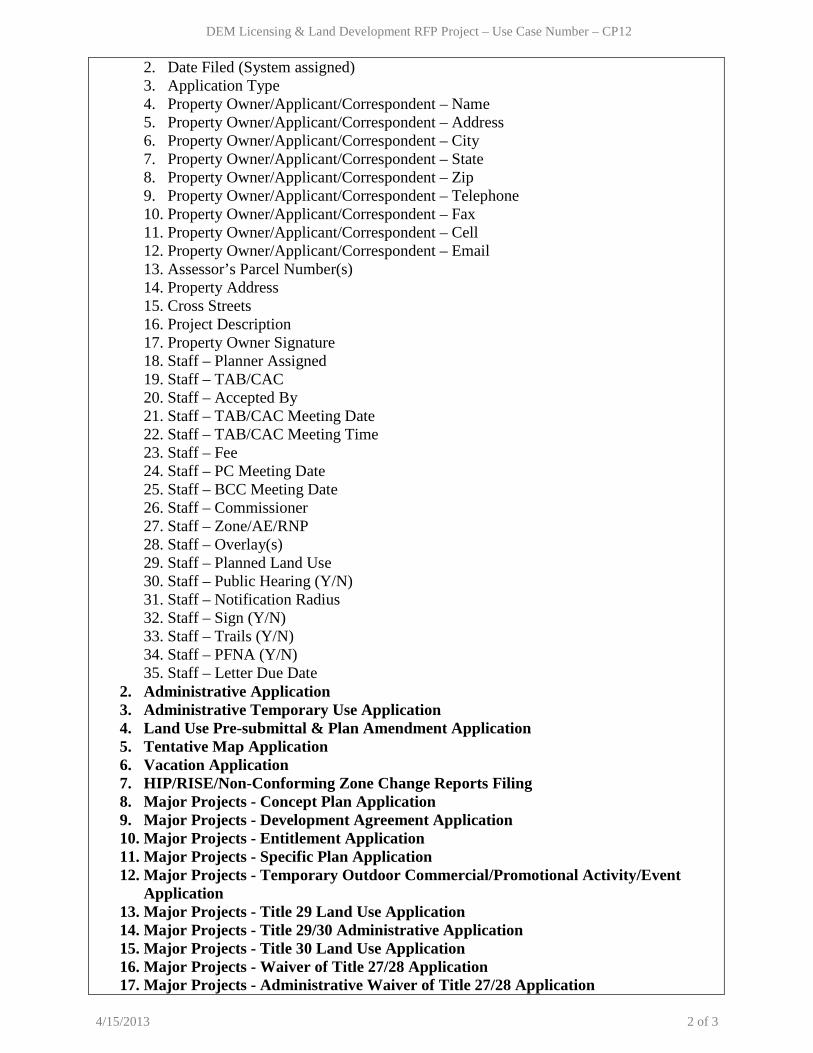
DEM Licensing & Land Development RFP Project – Use Case Number – CP12
2. Date Filed (System assigned) 3. Application Type 4. Property Owner/Applicant/Correspondent – Name 5. Property Owner/Applicant/Correspondent – Address 6. Property Owner/Applicant/Correspondent – City 7. Property Owner/Applicant/Correspondent – State 8. Property Owner/Applicant/Correspondent – Zip 9. Property Owner/Applicant/Correspondent – Telephone 10. Property Owner/Applicant/Correspondent – Fax 11. Property Owner/Applicant/Correspondent – Cell 12. Property Owner/Applicant/Correspondent – Email 13. Assessor’s Parcel Number(s) 14. Property Address 15. Cross Streets 16. Project Description 17. Property Owner Signature 18. Staff – Planner Assigned 19. Staff – TAB/CAC 20. Staff – Accepted By 21. Staff – TAB/CAC Meeting Date 22. Staff – TAB/CAC Meeting Time 23. Staff – Fee 24. Staff – PC Meeting Date 25. Staff – BCC Meeting Date 26. Staff – Commissioner 27. Staff – Zone/AE/RNP 28. Staff – Overlay(s) 29. Staff – Planned Land Use 30. Staff – Public Hearing (Y/N) 31. Staff – Notification Radius 32. Staff – Sign (Y/N) 33. Staff – Trails (Y/N) 34. Staff – PFNA (Y/N) 35. Staff – Letter Due Date
2. Administrative Application 3. Administrative Temporary Use Application 4. Land Use Pre-submittal & Plan Amendment Application 5. Tentative Map Application 6. Vacation Application 7. HIP/RISE/Non-Conforming Zone Change Reports Filing 8. Major Projects - Concept Plan Application 9. Major Projects - Development Agreement Application 10. Major Projects - Entitlement Application 11. Major Projects - Specific Plan Application 12. Major Projects - Temporary Outdoor Commercial/Promotional Activity/Event
Application 13. Major Projects - Title 29 Land Use Application 14. Major Projects - Title 29/30 Administrative Application 15. Major Projects - Title 30 Land Use Application 16. Major Projects - Waiver of Title 27/28 Application 17. Major Projects - Administrative Waiver of Title 27/28 Application
4/15/2013 2 of 3

DEM Licensing & Land Development RFP Project – Use Case Number – CP12
18. Zoning Letter and Research Request Form 19. Address Change Request Form
Maps:
1. Tenant Map 2. Final Map 3. Map Check Map 4. Recorded Map
Search Criteria: Security Requirement(s): Data Retention: Comments:
4/15/2013 3 of 3

DEM Licensing & Land Development RFP Project – Use Case Number – CP13
Department Name: Comprehensive Planning Process Name: On-line appointments Use Case Number: CP13 Use Case Name: Schedule Appointment Created By: Diane Weatherholt and Karthik Chandran Level: User Goal Description: Schedule, Re-schedule, and Cancel appointment for application/map/plan review by the Planner. Primary Actor: Customer Other Stakeholders: Office Support Pre-condition: The application, maps and plans to be reviewed should exist in the system. Post-condition: User is able to schedule, reschedule and cancel a review appointment. Trigger: Customer submits an application for approval. Related Use Case(s): NA
Primary Actor System Main Path: Schedule Plan Review Rate
1. User logs in to the Web Portal of the Land Management System and navigates to the Schedule Appointment screen.
2. User enters the application number and selects to search.
3. System displays the application.
4. User selects to schedule a planner appointment.
5. System displays the Appointment Information screen.
6. User enters the Appointment Information and selects to save.
7. System saves the appointment information and sends a confirmation notice to the customer and appropriate Planner or Office Support.
Alternate Path 1: View Prior Appointments 1.1 (At Step 4) User selects to view prior
appointments. 1.2 System displays all the prior
appointments for the application.
1.3 User selects to view an appointment. 1.4 System displays the Appointment Information.
Alternate Path 2: Reschedule Appointments 2.1 (At Step 2) User enters the Search
Criteria and selects to search. 2.2 System displays all the appointments as
per the search criteria.
2.3 User selects the appointment to be rescheduled.
2.4 System displays the Reschedule Appointment screen.
2.5 User enters the Reschedule Appointment Information and selects to save.
2.6 System saves the rescheduled appointment and sends a confirmation notice to the customer and appropriate Planner or Office Support.
Alternate Path 3: Cancel Appointment – User should be able to cancel an appointment.
Business Rules: BR-1 (At Step 2.6, AP3): System must maintain the audit data. BR-2 (At Step 7, 2.6): System should to send email reminders to the customer about the appointment. Design: 4/15/2013 1 of 2

DEM Licensing & Land Development RFP Project – Use Case Number – CP13
Appointment Information: (At Step 6, 1.4)
1. Application Number - Unique ID for the application. 2. Application Type - Type of application. E.g. ADR, PUD, SNC, TM 3. Tenant Name - Name of tenant. 4. Tenant Phone Number - Phone number of tenant. 5. Tenant Email Address - Email address of tenant. 6. Parcel Number(s) - Assessor’s Parcel Number 7. Property Address - Address Information 8. Project Description - Description of project. 9. Appointment Request Date - Requested appointment date. 10. Appointment Request Time - Requested appointment time. 11. Planner Assigned - Planner who has been assigned. 12. Comments - Comments for the appointment.
Reschedule Appointment Information: (At Step 2.5)
1. Planner ID - Planner ID 2. Appointment Date - Appointment Date 3. Appointment Time - Appointment Time
Search Criteria: 1. Application Number - Unique ID for the application. 2. Planner ID - Unique ID for Planner. 3. Date Range - From and To Dates.
Security Requirement(s): Data Retention: Comments:
4/15/2013 2 of 2

DEM Licensing & Land Development RFP Project – Use Case Number – CP14
Department Name: Comprehensive Planning Process Name: Tracking Applications, Street Address Maintenance Use Case Number: CP14 Use Case Name: Review and Update Application, Maps and Plans Created By: Phil Blount, Greg Cerven, Dave Brown, Sandy McClendon, Mara Weber, Diane Weatherholt, and Karthik Chandran Level: User Goal Description: Review and update Applications, Maps, Plans and Documents submitted to Comprehensive Planning Department for completeness and conformance to standards. Primary Actor: Planner, Zoning Plans Checker, Management Analyst, Office Admin, Office Support Other Stakeholders: Customer Pre-condition: Application, Maps and Plans should exist in the system. Post-condition: User is able to review and update the application, maps, plans, and other documents. Trigger: Customer submits application, maps, plans, and documents for approval. Related Use Case(s): NA
Primary Actor System Main Path: Update Application Rate
1. User logs in to the Land Management System and navigates to the Review Applications screen.
2. User enters the Search Criteria and selects to search.
3. System displays the applications as per the search criteria.
4. User selects the application to review. 5. System displays the application. 6. User reviews the application, makes
updates or enters comments and selects to save.
7. System saves the updated application and notifies the applicant about the review status and comments.
Alternate Path 1: Update Maps, Plans and Documents
1.1 (At Step 6) User selects to review the maps, plans or documents attached to the application.
1.2 System displays the selected maps, plans or documents.
1.3 User reviews the maps, plans or documents, makes updates and selects to save.
1.4 System saves the updated information and notifies the applicant about the review status/comments.
Alternate Path 2: View Application/Map/Plan – System should be able to display read only information for applications, maps, plans and documents.
Alternate Path 3: Print Application/Map/Plan – User should be able to print applications, maps, plans and documents.
Business Rules: BR-1 (At Step 7, 1.4): System must maintain the audit data. BR-2 (At Step 1.3): System should provide the capability for redlining, markups and revision tracking.
4/15/2013 1 of 2
DEM Licensing & Land Development RFP Project – Use Case Number – CP14
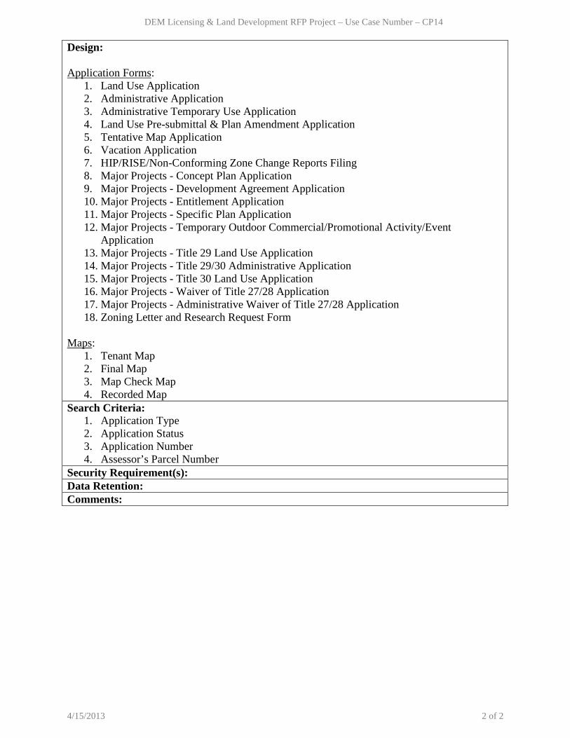
Design: Application Forms:
1. Land Use Application 2. Administrative Application 3. Administrative Temporary Use Application 4. Land Use Pre-submittal & Plan Amendment Application 5. Tentative Map Application 6. Vacation Application 7. HIP/RISE/Non-Conforming Zone Change Reports Filing 8. Major Projects - Concept Plan Application 9. Major Projects - Development Agreement Application 10. Major Projects - Entitlement Application 11. Major Projects - Specific Plan Application 12. Major Projects - Temporary Outdoor Commercial/Promotional Activity/Event
Application 13. Major Projects - Title 29 Land Use Application 14. Major Projects - Title 29/30 Administrative Application 15. Major Projects - Title 30 Land Use Application 16. Major Projects - Waiver of Title 27/28 Application 17. Major Projects - Administrative Waiver of Title 27/28 Application 18. Zoning Letter and Research Request Form
Maps:
1. Tenant Map 2. Final Map 3. Map Check Map 4. Recorded Map
Search Criteria: 1. Application Type 2. Application Status 3. Application Number 4. Assessor’s Parcel Number
Security Requirement(s): Data Retention: Comments:
4/15/2013 2 of 2

DEM Licensing & Land Development RFP Project – Use Case Number – CP15
Department Name: Comprehensive Planning Process Name: Tracking Applications, Street Address Maintenance Use Case Number: CP15 Use Case Name: Create, Update, and View Project Created By: Greg Cerven, Phil Blount, Dave Brown, Mario Bermudez, Sandy McClendon, Mara Weber, Diane Weatherholt, Kelly Petras, and Karthik Chandran Level: User Goal Description: Create a new project for any application, map, or plan submitted to Comprehensive Planning Department by the customer. View, update, and print project information. Primary Actor: Planner, Zoning Plans Checker, Planning Manager, Management Analyst, Office Admin, Office Support, Agenda Processing Admin Other Stakeholders: Customer Pre-condition: Application/map/plan should either exist in the system or should be provided by customer. Post-condition: User is able to create and update project information for any application/map/plan submitted by the customer. Trigger: Receive an application/map/plan submitted online or in person. Related Use Case(s): BL-11- Create special use and event permit application
Primary Actor System Main Path: Create Project – Online Application Submittal
Rate
1. User logs in to the Land Management System and navigates to the Create Project screen.
2. User enters the Search Criteria and selects to search for an application.
3. System displays the search results.
4. User selects an application. 5. System displays the application information.
6. User selects to create a new project for the application.
7. System displays a new project screen with information pre-populated from the application, maps, plans and documents.
8. User enters Project General, Location, Contact, & Custom Information and selects to save.
9. System creates a new project, assigns a unique identifier and links it to the application, maps, plans and documents.
Alternate Path 1: Create Project – In Person Application Submittal
1.1 (At Step 2) User selects to enter a new project.
1.2 System displays a new project screen.
1.3 User enters Project General, Location, Contact, & Custom Information and selects to save.
1.4 System creates a new project and assigns it a unique identifier. System displays a document attachment screen.
1.5 User selects to attach application, maps, plans and other documents.
1.6 System saves and links the project to the application, maps, plans and documents.
Alternate Path 2: Update Project - User should be able to update the project information.
Alternate Path 3: View Project – System
4/15/2013 1 of 3

DEM Licensing & Land Development RFP Project – Use Case Number – CP15
should be able to display read only project information. Alternate Path 4: Print Project Information – User should be able to print the project information.
Business Rules: BR-1 (At Step 9): System must assign a unique identifier for a project. The project must be linked to the application, maps, plans and documents. BR-2 (At Step 9): One application will be associated to one project in most cases. Sometimes Zone Change, Design Review, Use Permit and Waiver of Standards applications for a property are all associated to one project. BR-3 (At Step 3): System should display Building Permit Applications assigned to the Zoning Plans Checker. BR-4 (At Step 8, 1.3): For Building Permit Applications, the Structure Setup Information should also be displayed. BR-5 (At Step 8): A project can have multiple Town Board names associated with it. Design:
• Project General Information (At Step 8, 1.3) 1. Project Number - Unique ID for the project. 2. Project Description - Description of the project. 3. Application Number - Unique ID for the application. 4. Application Date - Date the application was submitted. 5. Application Type - Application type. 6. Project Status - Project status. 7. Owner Name - Name of owner 8. Map Name - Name of map 9. Planner Assigned - Name of the assigned planner. 10. Engineer Assigned - Name of the assigned engineer. 11. Accounting Project Number - ? 12. Number of Dwelling Units - Number of dwelling units 13. Total Square Footage - Total area in square feet. 14. Building Permit Notify - Indicator to notify building permits. 15. Permit Process - ? 16. Zone Code - E.g. P-F (Public facility district) 17. Total Estimated Value - 18. Tenant Number - Suite number 19. Tenant Name - Subdivision name, Shopping center name or
the name of the business. 20. Public Building Flag - E.g. Public/Private 21. Master Plan Number - 22. Application Group -
• Project Location Information (At Step 8, 1.3) 1. Parcel Number - Assessor’s Parcel Number. 2. Project Address - Address of the project.
• Project Contact Information (At Step 8, 1.3)
1. Contact Type - Type of contact. (E.g. Owner, Correspondent)
4/15/2013 2 of 3

DEM Licensing & Land Development RFP Project – Use Case Number – CP15
2. Contact Name - Name of the contact. 3. Contact Address - Address of the contact. 4. Contact Phone - Phone of the contact. 5. Contact Email - Email of the contact.
• Project Custom Information (At Step 8, 1.3)
1. Data Item - Custom Data Fields (E.g. Recordation Information such as Plat Book Number for a recorded map, Recordation Date, Reference File Number, Codes, Freeform Text, Miscellaneous Information).
2. Data Value - Values for the data items. 3. Date - Date the data value was created or updated.
• Structure Setup Information – Only for Building Permit Applications (At Step 8, 1.3)
1. Number of Plans - Yes, if plans were submitted. 2. Number/Dwelling Units - Number of units if more than one unit is affected by
the address change. 3. Address File - Name of the town if parcel is in an outlying area. 4. Zoning Applications - Land Use Application Number if land use approval
was required. 5. Reviewed Under Title - Code that the application was reviewed under (E.g.
Title 29 or 30). Search Criteria:
Search Criteria: (At Step 2) 1. Assessor’s Parcel Number 2. Project Number 3. Application Number 4. Application Type 5. Application Status
Security Requirement(s): Data Retention: Comments:
4/15/2013 3 of 3

DEM Licensing & Land Development RFP Project – Use Case Number – CP16
Department Name: Comprehensive Planning Process Name: Tracking Applications, Street Address Maintenance, Tracking Building Zoning Plan, BD020–Zoning Plan Review, Public Works - PAC Review Use Case Number: CP16 Use Case Name: Create, Signoff and View Project Review Created By: Greg Cerven, Phil Blount, Dave Brown, Mario Bermudez, Sandy McClendon, Mara Weber, Diane Weatherholt, Kelly Petras, and Karthik Chandran Level: User Goal Description: Create a new review for a project. Update and signoff an existing project review. View and print project review information. Primary Actor: Planner, Zoning Plans Checker, Planning Manager, Management Analyst, Office Admin, Office Support, Agenda Processing Admin Other Stakeholders: NA Pre-condition: Project should exist in the system. Post-condition: User is able to create, update, view, and signoff a project review. Trigger: Receive a request to create, update, view, or signoff a project review. Related Use Case(s): BD046-Permit Issue (for Zoning Review) PW042: Submit and Review Major Subdivision Map PW035-Submit and Review Minor Subdivision Map PW048-Zoning_Agenda Review
Primary Actor System Main Path: Create Project Review Rate
1. User logs in to the Land Management System and navigates to the Create Project Review screen.
2. User enters the Search Criteria and selects to search for a project.
3. System displays projects as per the search criteria.
4. User selects a project. 5. System displays all the Project Actions assigned to the user.
6. User selects a project action. 7. System displays all the Project Reviews for the project action.
8. User selects a project review. 9. System displays all the Review Steps for the review.
10. User selects a review step. 11. System displays Review Step Information.
12. User enters Review Step Information and selects to save.
13. System saves the project review information.
Alternate Path 1: Signoff Project Review 1.1 (At Step 12) User updates the review
status to “Approved” and selects to save. 1.2 System saves the project review signoff.
Alternate Path 2: Update Project Review - User should be able to update the project review information.
Alternate Path 3: View Project Review – System should be able to display read only project review information.
Alternate Path 4: Print Project Review - User should be able to print project review
4/15/2013 1 of 3

DEM Licensing & Land Development RFP Project – Use Case Number – CP16
information. Business Rules: BR-1 (At Step 5): Project Action is the type of action to be performed in a project. The System must provide the ability to create and maintain different types of Project Actions. (E.g. Vacation and Abandonment, Waiver of Standards, Zone Boundary Amendment, Extension of Time, Text Amendment etc.) BR-2 (At Step 7): Project Review is the type of review to be performed under a project action. System must provide the ability to create and maintain different Project Reviews. (E.g. Temporary Commercial Permit, Final Map Technical Review etc.) BR-3 (At Step 11): Review Step is one of the steps of a project review. System must provide the ability to create and maintain different Review Steps. (E.g. Review Application/Signature/Plans, Town Board Meeting, Planning Commission Meeting, Board of County Commissioners Meeting etc.) BR-4 (At Step 11): System must provide the ability to maintain associations between different project actions, project reviews, and review steps. BR-5 (At Step 11): The review comments must be date and time stamped with the user id. A user’s comment should not be allowed to be updated by other users. BR-6 (At Step 12): Agenda Log Amendments should be maintained in the review step information. BR-7 (At Step 12): System must provide the ability to put a hold and lift a hold on a review step. System must not allow the review step to be approved if there is a hold on it. BR-8 (At Step 12): System must provide the ability to display due dates for the application processing cycles in Agenda Review Schedule document maintained by Agenda Processing Design:
• Project Action (At Step 5) 1. Project Action Number - Unique ID for the project action. 2. Project Action Description - Description of the project action. (E.g.
Temporary Use Permit, Final Map, Vacation and Abandonment, Waiver of Standards, Zone Boundary Amendment, Extension of Time, Text Amendment etc.)
3. Status - Indicates if a project action is under review. 4. Revision Number - Revision number for the project action. 5. Date Started - Date the project action was started.
• Project Review (At Step 7)
1. Project Review Number - Unique ID for the project review. 2. Project Review Description - Description of the project review. (E.g.
Temporary Commercial Permit, Temporary Residential Permit, Final Map Technical Review etc.)
3. Status - Indicates if a project review is under review. 4. Revision Number - Revision number for the project review. 5. Date Started - Date the project review was started.
4/15/2013 2 of 3

DEM Licensing & Land Development RFP Project – Use Case Number – CP16
• Review Step Information (At Step 11) 1. Review Step Number - Unique ID of the review step. 2. Review Step Description - Description of the review step. (E.g.
Review Application/Signature/Plans, Addressing Review, Zoning Review, Town Board Meeting, Planning Commission Meeting, BCC Meeting etc.)
3. Review Status - Status of the review step. (E.g. Approved, Denied, Call Placed)
4. Review Date - Date for the review step. (E.g. Hearing date, Expiration/Commencement Date - before which customer has to start construction)
5. Review Comments - Comments for the review step. 6. Assigned By - Person who entered/updated the review
status/date/comments. 7. Assigned Date - Date the review status/date/comments was
entered/updated. Search Criteria:
Search Criteria: (At Step 2) 1. Project Number 2. Application Number 3. Parcel Number
Security Requirement(s): Data Retention: Comments:
4/15/2013 3 of 3
DEM Licensing & Land Development RFP Project – Use Case Number – CP17
Department Name: Comprehensive Planning Process Name: Tracking Applications, Street Address Maintenance, Tracking Building Zoning Plan, Print PC/BCC Logs Use Case Number: CP17 Use Case Name: Create, Update, and View Project Conditions and Comments Created By: Greg Cerven, Phil Blount, Dave Brown, Mario Bermudez, Sandy McClendon, Mara Weber, Diane Weatherholt, Kelly Petras and Karthik Chandran Level: User Goal Description: Create a new condition or comment for a project. Update, view, and print existing project conditions or comments. The conditions/comments are used to create project documents. Primary Actor: Planner, Zoning Plans Checker, Planning Manager, Management Analyst, Office Admin, Office Support, Agenda Processing Admin, Other Agencies (E.g. Public Works) Other Stakeholders: NA Pre-condition: Project should exist in the system. Post-condition: User is able to create, update, view, and print project conditions or comments. Trigger: Receive a request to create, update, or view a project condition/comment. Related Use Case(s):
Primary Actor System Main Path: Create Project Conditions/Comments
Rate
1. User logs in to the Land Management System and navigates to the Project Conditions and Comments screen.
2. User enters the Search Criteria and selects to search for a project.
3. System displays projects as per the search criteria.
4. User selects a project. 5. System displays the Conditions/Comments Summary screen.
6. User enters Conditions/Comments Summary and selects to enter detailed comments.
7. System opens the Conditions/Comments Detail document (E.g. MS Word).
8. User enters the Conditions/Comments Detail and selects to save.
9. System saves the project conditions or comments.
Alternate Path 1: Update Project Conditions/Comments – System should provide the ability to update or delete sections of the project conditions or comments.
Alternate Path 2: View Project Conditions/Comments – System should be able to display read only project conditions or comments.
Alternate Path 3: Print Project Conditions/Comments - User should be able to print project conditions or comments.
Business Rules: BR-1 (At Step 7): System must provide the ability to maintain different document templates
4/15/2013 1 of 2

DEM Licensing & Land Development RFP Project – Use Case Number – CP17
(MS Word) for different types of conditions and comments (E.g. Application types, Map types). BR-2 (At 9, AP1): System must maintain audit data. Design: Conditions/Comments Summary: (Step 6)
1. Project Number - Project number. 2. Project Description - Project description. 3. Type - Type of Conditions or Comments. (E.g. Addressing
comments list, Analysis, Approvals/Protests, Heading (All Profiles), Owner, PW Development Review Recs, Land Use Summary Paragraph, Water Reclamation, Department of Aviation, Health District etc.)
4. Public/Private - Indicates if the condition/comment is public or private Conditions/Comments Detail Document: (Step 7)
1. Heading Section 2. Summary Section 3. Analysis Section 4. Approvals Section 5. Owner Information Section 6. Other Agencies Section
Search Criteria: Search Criteria: (At Step 2) 1. Project Number 2. Application Number 3. Parcel Number
Security Requirement(s): Data Retention: Comments:
1. Project comments can be created and reviewed by other agencies (E.g. Public Works).
4/15/2013 2 of 2

DEM Licensing & Land Development RFP Project – Use Case Number – CP18
Department Name: Comprehensive Planning Process Name: Tracking Applications, Street Address Maintenance, Tracking Building Zoning Plan, Merge Staff Report Use Case Number: CP18 Use Case Name: Create, Update, and View Project Documents Created By: Greg Cerven, Phil Blount, Mario Bermudez, Dave Brown, Sandy McClendon, Kelly Petras, Mara Weber, Diane Weatherholt and Karthik Chandran Level: User Goal Description: Merge different project comments/conditions and create a new document/write up for a project (E.g. Final Staff Report, Correction Letters, and Address Change Letter). Update, view, and print existing project documents. Primary Actor: Planner, Planning Manager, Zoning Plans Checker, Management Analyst, Agenda Processing Admin, Office Admin, Office Support Other Stakeholders: NA Pre-condition: Project comments/conditions should exist for the project. Post-condition: User is able to merge project comments/conditions into one document. Trigger: Receive a request to create, update, or view a project document. Related Use Case(s):
Primary Actor System Main Path: Create Project Document Rate
1. User logs in to the Land Management System and navigates to the Project Document screen.
2. User enters the Search Criteria and selects to search for a project.
3. System displays projects as per the search criteria.
4. User selects a project to create a document.
5. System displays the Project Document Information.
6. User enters Project Document Information and selects various project comments/conditions to merge.
7. System merges the selected project comments/conditions into one document and saves it.
Alternate Path 1: Update Project Document – System should provide the ability to update or delete sections of the project document.
Alternate Path 2: View Project Document – System should be able to display read only project document.
Alternate Path 3: Print Project Document - User should be able to print project document.
Business Rules: BR-1 (At Step 5): System must provide the ability to maintain different document templates (MS Word) for different types of Documents (E.g. Final Staff Report, Correction Letters, and Address Change Letter). Design: Project Document Information: (At Step 6)
1. Project Number - Project number.
4/15/2013 1 of 2

DEM Licensing & Land Development RFP Project – Use Case Number – CP18
2. Project Description - Project description 3. Document Description - Description for the project document. 4. Property Address - Address of the property. 5. Agency Code - Code for the department/agency. 6. Select Project Comment - Indicator to include project comments. 7. Select Project Conditions - Indicator to include project conditions. 8. Base document to include - Document template to be used. 9. Public/private document - Indicates if the document is public or private.
Project Documents:
1. Draft/Final Staff Report 2. Agenda Sheet 3. PC/BCC Agenda Log Amendment 4. PC/BCC Agenda Log Amendment List 5. Conditions of Approval 6. Approval/Denial Letter 7. Correction Letter 8. Address Change Letter 9. Zoning Letter 10. RISE/PFNA Report for Water Supply 11. RISE/PFNA Report for Wastewater Treatment 12. RISE/PFNA Report for Transportation 13. RISE/PFNA Report for Geotechnical 14. RISE/PFNA Report for Flood Control and Drainage 15. RISE/PFNA Report for Fire Protection and Emergency Services 16. RISE/PFNA Report for Police Services 17. RISE/PFNA Report for Educational Services 18. RISE/PFNA Report for Neighborhood, Economic and Employment 19. RISE/PFNA Report for Parks and Trails 20. RISE/PFNA Report for Desert Conservation Program 21. RISE/PFNA Report for Air Quality 22. RISE/PFNA Report for Water Quality
Search Criteria: Search Criteria: (At Step 2) 1. Project Number 2. Application Number 3. Parcel Number
Security Requirement(s): Data Retention: Comments:
4/15/2013 2 of 2

DEM Licensing & Land Development RFP Project – Use Case Number – CP19
Department Name: Comprehensive Planning Process Name: Tracking Applications, Tracking Building Zoning Plan, Comp Planning - Fee Payment Process Use Case Number: CP19 Use Case Name: Create, Update, and View Fees and Receipts Created By: Phil Blount, Dave Brown, Mara Weber, Diane Weatherholt, Kelly Petras, Sandy McClendon, and Karthik Chandran Level: User Goal Description: Enter, update, and view fee information for a project. Create, void, view, and print project or miscellaneous fee receipts. Primary Actor: Planner, Zoning Plans Checker, Office Admin, Office Support, Agenda Processing Admin, Management Analyst Other Stakeholders: NA Pre-condition: Project should exist in the system. Post-condition: User is able to enter, update, and view fees or create receipts. Trigger: Receive a request to enter, update, and view fees or create receipts. Related Use Case(s):
Primary Actor System Main Path: Enter Project Fees Rate
1. User logs in to the Land Management System and navigates to the Maintain Fees screen.
2. User selects to enter project fees. 3. System displays the project fee screen. 4. User enters the Search Criteria and
selects to search for a project. 5. System displays the search results.
6. User selects a project. 7. System displays all the fee types for the project.
8. User enters Project Fee Information for the appropriate fee types and selects to save.
9. System saves fee information.
Alternate Path 1: Create Project Fee Receipt 1.1 (At Step 2) User selects to create a fee
receipt for the project. 1.2 System displays the project receipt
screen.
1.3 User enters the Search Criteria and selects to search for a project.
1.4 System displays the search results.
1.5 User selects a project. 1.6 System displays the Fee Receipt Information.
1.7 User enters Fee Receipt Information and selects to save.
1.8 System creates a new fee receipt and assigns it a unique identifier.
Alternate Path 2: Create Miscellaneous Fee Receipt
2.1 (At Step 2) User selects to create a fee receipt for a miscellaneous item.
2.2 System displays the Fee Receipt Information.
2.3 User enters Fee Receipt Information and selects to save.
2.4 System creates a new fee receipt and assigns it a unique identifier.
Alternate Path 3: Update Fees - User should be able to update the project fee information.
Alternate Path 4: Void Receipts - User should
4/15/2013 1 of 3

DEM Licensing & Land Development RFP Project – Use Case Number – CP19
be able to void a fee receipt. Alternate Path 5: View Fees/Receipts – System should be able to display read only fee and receipt information.
Alternate Path 6: Print Fee/Receipt Information – User should be able to print the project fee information and fee receipts.
Alternate Path 7: Email Fee/Receipt – User should be able to email fee receipts.
Business Rules: BR-1 (At Step 8): System must provide the ability to select a default amount, enter a new amount or enter the number of units to calculate fee amount. BR-2 (At Step 8): System should be able to display the reference fee sheet. BR-3 (At Step 2.3): Miscellaneous receipts have no associated address or parcel number (E.g. Fees for GIS Maps, Title 30 on CD, Copies of Document, etc.). BR-4 (At Step 1.7, 2.3): System must not allow a receipt to be created if the fee payment (project review step) has not been signed off. Design:
• Project Fee Information (At Step 8) 1. Project Number - Unique ID for the project. 2. Project Description - Description of the project. 3. Deposit Balance - ? 4. Fee Code(s) - Unique ID for the fee type. 5. Fee Description - Description of the fee type. 6. Fee Amount - Fee amount. 7. Fee per Unit - Fee amount charged for every unit. (E.g.
Fee per hour). 8. Fee Unit - Type of fee unit (E.g. Hour). 9. Number of Units - Number of fee units (E.g. Number of hours). 10. Amount Paid - Amount paid by customer. 11. Amount Due - Amount due by customer.
• Fee Receipt Information (At Step 1.6, 2.2)
1. Receipt Number - Unique ID for the receipt. 2. Fee Code - Unique ID for the fee type. 3. Fee Description - Description of the fee type. 4. Fee Amount - Fee amount. 5. Fee per Unit - Fee amount charged for every unit. (E.g.
Fee per hour). 6. Fee Unit - Type of fee unit (E.g. Hour). 7. Number of Units - Number of fee units (E.g. Number of hours). 8. Amount Paid - Amount paid by customer. 9. Payment Method - Cash, check or money order. Credit card in
future. 10. Check Number - Check Number. 11. Credit Card Number - Credit Card Number (Last four digits?) 12. Credit Card Type - Type of Credit Card (E.g. Visa, Mastercard) 13. Received By - Unique ID for the cashier.
4/15/2013 2 of 3

DEM Licensing & Land Development RFP Project – Use Case Number – CP19
14. Received From - Name of payer. 15. Payment Date - Date of payment. 16. Payment Time - Time of payment. 17. Project Number - If applicable. 18. Project Description - If applicable.
Search Criteria: Search Criteria: (At Step 2, 1.3)
1. Assessor’s Parcel Number 2. Project Number 3. Application Number 4. Application Type 5. Application Status
Security Requirement(s): Data Retention: Comments:
4/15/2013 3 of 3

DEM Licensing & Land Development RFP Project – Use Case Number – CP20
Department Name: Comprehensive Planning Process Name: Tracking Applications Use Case Number: CP20 Use Case Name: Create and Distribute Project Notification Created By: Diane Weatherholt, Sandy McClendon, and Karthik Chandran Level: User Goal Description: Create, save and distribute project notifications. Primary Actor: Office Support, Management Analyst Other Stakeholders: Customer, Other Agencies/Departments Pre-condition: NA Post-condition: User is able to create, save and distribute project notifications. Trigger: Receive a request to distribute notifications. Related Use Case(s): NA
Primary Actor System Main Path: Create Notifications Rate
1. User logs in to the Land Management System and navigates to the Notification screen.
2. User enters the Search Criteria and selects to search.
3. System displays the search results.
4. User selects a project to create a notification.
5. System displays the Notification Information.
6. User enters the Notification Information and selects to distribute or save.
7. System distributes or saves the notification.
Alternate Path 1: Attach Documents – System should provide the ability to attach applications, plans, maps and other project documents to the notification.
Business Rules: BR-1 (At Step 6): System must provide the ability to create and maintain distribution lists for notifications (E.g. Contact list for various Town Boards). BR-2 (At Step 6): System must provide the ability to include general project information, location information, contact information, and project comments/conditions in the notification. Design: Notification Information: (At Step 5)
1. Sender - Sender of the notification. 2. Receiver - Receiver of the notification. 3. Subject - Subject of the notification. 4. Notification Text - Body of the notification. 5. Project/Application Number - Unique ID for the Project/Application. 6. Assessor’s Parcel Number - Parcel number for the project (if applicable). 7. Address - Property address for the project (if applicable). 8. Due Date - Due date for response (if applicable).
Search Criteria:
4/15/2013 1 of 2

DEM Licensing & Land Development RFP Project – Use Case Number – CP20
Search Criteria: (At Step 2) 1. Assessor’s Parcel Number 2. Project Number 3. Application Number 4. Application Type 5. Application Status
Security Requirement(s): Data Retention: Comments:
1. Preliminary Zoning review requests submitted from Comprehensive Planning shall be submitted electronically to Fire Department and must include the below information:
a. Due Date (Date the review must be complete) b. APN (Assessor Parcel Number under review-if available) c. Address or GIS (Address or GIS coordinates under review) d. Zoning Detail (Additional details Zoning has to provide, attachments, what is the
existing land use/zoning etc) e. Purpose of Review (Purpose of why the review is being done)
2. Preliminary Zoning review requests submitted from Comprehensive Planning to the Fire
Department shall allow up to 5 business days for review from submission date.
4/15/2013 2 of 2

Department Name: Comprehensive Planning Process Name: Tracking Applications, Street Address Maintenance, Tracking Building Zoning Plan, Word Search Use Case Number: CP21 Use Case Name: Inquire Project Information Created By: Greg Cerven, Phil Blount, Dave Brown, Mario Bermudez, Sandy McClendon, Nichole Krause, Diane Weatherholt, Kelly Petras, and Karthik Chandran Level: User Goal Description: Inquire and print project general, location, contact, and custom
information for various search criteria. Primary Actor: Planner, Planning Manager, Zoning Plans Checker, Management Analyst, Office Admin, Office Support, Agenda Processing Admin Other Stakeholders: NA Pre-condition: The projects should exist in the system. Post-condition: User is able to inquire project information for different search criteria. Trigger: Receive a request to inquire project information. Related Use Case(s): NA Primary Actor System Main Path: Inquire General Information Rate
1. User logs in to the Land Management System and navigates to the Inquire Project screen.
2. User selects to inquire general project information.
3. System displays inquire general information screen.
4. User enters the Search Criteria and selects to search.
5. System displays the Project General Information as per the search criteria.
Alternate Path 1: Inquire Location Information 1.1 (At Step 2) User selects to inquire
project location information. 1.2 System displays inquire location
information screen.
1.3 User enters the Search Criteria and selects to search.
1.4 System displays the Project Location Information as per the search criteria.
Alternate Path 2: Inquire Contact Information 2.1 (At Step 2) User selects to inquire
project contact information. 2.2 System displays inquire contact
information screen.
2.3 User enters the Search Criteria and selects to search.
2.4 System displays the Project Contact Information as per the
search criteria. Alternate Path 3: Inquire Custom Information
3.1 (At Step 2) User selects to inquire project custom information.
3.2 System displays inquire custom information screen.
3.3 User enters the Search Criteria and selects to search.
3.4 System displays the Project Custom Information as per the search criteria.
Alternate Path 4: Print Project Information – User should be able to print the project information.
Business Rules: BR-1 (At Step 5): System should provide the ability to retrieve all historical project information. BR-2 (At Step 5): System should provide the structure setup information for building permit applications. Design:
• Project General Information (At Step 5) 1. Project Number - Unique ID for the project. 2. Project Description - Description of the project. 3. Application Number - Unique ID for the application. 4. Application Date - Date the application was submitted. 5. Application Type - Application type. 6. Project Status - Project status. 7. Owner Name - Name of owner 8. Map Name - Name of map 9. Planner Assigned - Name of the assigned planner. 10. Engineer Assigned - Name of the assigned engineer. 11. Accounting Project Number - ? 12. Number of Dwelling Units - Number of dwelling units 13. Total Square Footage - Total area in square feet. 14. Building Permit Notify - Indicator to notify building permits. 15. Permit Process - ? 16. Zone Code - E.g. P-F (Public facility district) 17. Total Estimated Value - 18. Tenant Number - Suite number 19. Tenant Name - Subdivision name, Shopping center name or
the name of the business. 20. Public Building Flag - E.g. Public/Private 21. Master Plan Number - 22. Application Group -
• Project Location Information (At Step 1.4)

1. Parcel Number - Assessor’s Parcel Number for the project. 2. Project Address - Address of the project. 3. Subdivision - Subdivision for the project. 4. Range-Township-Section - Range-Township-Section for the project. 5. Inspection Area - Inspection area for the project. 6. Plat Book Page - Plat Book Page for the project.
• Project Contact Information (At Step 2.4)
1. Contact Type - Type of contact. (E.g. Owner) 2. Contact Name - Name of the contact. 3. Contact Address - Address of the contact. 4. Contact Phone - Phone of the contact. 5. Contact Email - Email of the contact.
• Project Custom Information (At Step 4)
1. Data Item - Custom Data Fields (E.g. Recordation Information such as Plat Book Number for a recorded map, Recordation Date, Reference File Number, Codes, Freeform Text, Miscellaneous Information).
2. Data Value - Values for the data items. 3. Date - Date the data value was created or updated.
• Structure Setup Information – Only for Building Permit Applications (At Step 4)
1. Number of Plans - Yes, if plans were submitted. 2. Number/Dwelling Units - Number of units if more than one unit is affected by
the address change. 3. Address File - Name of the town if parcel is in an outlying area. 4. Zoning Applications - Land Use Application Number if land use approval
was required. 5. Reviewed Under Title - Code that the application was reviewed under (E.g.
Title 29 or 30). Search Criteria: Search Criteria: (At Step 2)
1. Project Number - Unique ID for the project. 2. Project Description - Description of the project. 3. Project Type Code - Code for the project type. 4. Project Status - Status of the project. 5. Project Status Type - Type of project status? 6. Project Type Agency - ? 7. Project Year - Year project was started 8. Property Address - Address of the property

9. Assessor’s Parcel Number - Parcel number for the address 10. Owner Name - Name of the owner 11. Map Name - Name of the map 12. Planner Assigned - Name of the planner assigned 13. Engineer Assigned - Name of the engineer assigned
Security Requirement(s): Data Retention: Comments:

DEM Licensing & Land Development RFP Project – Use Case Number – CP22
Department Name: Comprehensive Planning Process Name: NA Use Case Number: CP22 Use Case Name: Maintain Fee Code Created By: Mara Weber and Karthik Chandran Level: User Goal Description: Create and update fee codes. Associate fee code to application types. Primary Actor: Office Admin Other Stakeholders: NA Pre-condition: NA Post-condition: User is able to create, update and associate fee code to application type. Trigger: Receive a request to create, update or associate a fee code. Related Use Case(s):
Primary Actor System Main Path: Create Fee Code Rate
1. User logs in to the Land Management System and navigates to the Maintain Fee screen.
2. User selects to create a new fee. 3. System displays the New Fee screen. 4. User enters the Fee Information and
selects to save. 5. System saves the new fee information.
Alternate Path 1: Update Fee Code 1.1 (At Step 2) User selects to update an
existing fee. 1.2 System displays the Update Fee screen.
1.3 User enters the Search Criteria and selects to search.
1.4 System retrieves the fee.
1.5 User updates the Fee Information and selects to save.
1.6 System saves the updated fee information.
Business Rules: BR-1 (At Step 4, 1.5): Fee code can be inactivated but must not be deleted from the system so as to maintain historical information. BR-2 (At Step 4, 1.5): A fee code can have multiple application types and an application type can be associated to multiple fee codes. Fee code and application type association history must be maintained. Design:
• Fee Information (At Step 4, 1.5) 1. Fee Code - Unique code for the fee (2 digits). 2. Fee Description - Description of the fee code. 3. Fee Amount - Default amount for the fee code. 4. Fee per Unit - Fee amount charged for every unit. 5. Fee Unit - Unit based on which the fee is charged (E.g. Hour). 6. Revenue Account - Fund/Cost Center number for the fee. 7. Fee Status - Indicates if the fee is active or inactive. 8. Application Type - All application types associated to the fee code.
Search Criteria: Search Criteria: (At Step 1.3)
1. Fee Code 2. Fee Code Description
4/15/2013 1 of 2

DEM Licensing & Land Development RFP Project – Use Case Number – CP22
3. Fee Status 4. Application Type
Security Requirement(s): Data Retention: Comments:
4/15/2013 2 of 2
DEM Licensing & Land Development RFP Project – Use Case Number – CP23
Department Name: Comprehensive Planning Process Name: Search Business License capabilities, Status of Business License Use Case Number: CP23 Use Case Name: Search Business License Created By: Sandy McClendon and Karthik Chandran Level: User Goal Description: Provides the ability to search and view Business Licenses. Primary Actor: Management Analyst Other Stakeholders: NA Pre-condition: Business License exists in the system. Post-condition: User is able to search and view Business Licenses. Trigger: User receives a request to search for Business Licenses. Related Use Case(s): BL-03-01 Send License, BL-03-02
Primary Actor System Main Path: Search and View Business License
Rate
1. User logs in to the Business License System and navigates to the Search Business License screen.
2. User enters the Search Criteria and selects to search.
3. System displays all the licenses as per the search criteria.
4. User views the Business License Information.
Business Rules: Design: Business License Information: (At Step 4)
1. Business License Number - Unique ID for the Business License. 2. Business Name - Name of the business. 3. Owner Name - Name of the owner. 4. Business Type - Type of business. 5. Property Address - Address of the property. 6. Multi-J - Indicator for multi-jurisdictional. 7. License Status - Status of the license. 8. License Reason - Reason for the license.
Search Criteria: Search Criteria: (At Step 2) 1. Business License Number - Unique ID for the Business License. 2. Business Name - Name of the business. 3. Owner Name - Name of the owner. 4. Business Type - Type of business. 5. Property Address - Address of the property. 6. Multi-J - Indicator for multi-jurisdictional. 7. License Status - Status of the license. 8. License Reason - Reason for the license.
Security Requirement(s): Data Retention: Comments:
4/15/2013 1 of 1

DEM Licensing & Land Development RFP Project – Use Case Number – CP24
Department Name: Comprehensive Planning Process Name: Sign-off Business License Use Case Number: CP24 Use Case Name: Signoff Business License Zoning Review Created By: Sandy McClendon and Karthik Chandran Level: User Goal Description: Verify zoning information for the business license and signoff business license zoning review. Primary Actor: Management Analyst Other Stakeholders: NA Pre-condition: Business license exists in the system. Post-condition: User is able to signoff business license zoning review. Trigger: User receives a request to signoff business license zoning review. Related Use Case(s): CP26 - View GIS Information CP25 - View Certificate of Occupancy
Primary Actor System Main Path: Signoff Business License Zoning Review
Rate
1. User logs in to the Business License System and navigates to the Business License Zoning Review screen.
2. User enters the Search Criteria and selects to search.
3. System displays all the licenses as per the search criteria.
4. User selects a license to signoff. 5. System displays the Business License Zoning Information.
6. User reviews the Business License Zoning Information and selects to signoff.
7. System saves the business license zoning review signoff.
Business Rules: BR-1 (At Step 6): System should provide the ability for a user to check the land use conditions, zoning information, and Title 30 for the property before signoff. BR-2 (At Step 6): System should provide the ability for a user to check the status of temporary land use application or certificate of occupancy before signoff. BR-3 (At Step 6): When a business license tied to a land use application is renewed, system should display a message if the zoning review expiration date has passed. The system should also notify Comp Planning and Business License departments. Design: Business License Zoning Information: (At Step 5)
1. Business License Number - Unique ID for the Business License. 2. Business License Type - Type of Business License. 3. Business Name - Name of the business. 4. Address - Address of the business. 5. Phone - Phone for the business. 6. Owners - Owners of the property. 7. Alternate Owners - Alternate owners of the property. 8. Inspection Contact - Contact person for inspection.
4/15/2013 1 of 2

DEM Licensing & Land Development RFP Project – Use Case Number – CP24
9. Inspection Phone - Phone for inspection contact. 10. NV Business ID - Nevada business ID. 11. Parcel Number - Assessor’s Parcel Number. 12. Zoning - Zoning Code. 13. Business Description - Description of the business. 14. Location Description - Description of the location. 15. Application Date - Date application was submitted. 16. Zoning Status - Status of the zoning review. 17. Zoning Date - Date zoning review was approved. 18. Processing Due - Due date for application processing. 19. Projected Opening - Date of projected business opening. 20. Effective/License From Date - Effective date for the license. 21. Expiration/License To Date - Expiration date for the license. 22. Billing Cycle - Type of billing cycle. 23. Comments - License comments. 24. Business License Status - Status of business license. 25. Status Reason - Reason for the license status. 26. Date Last Activity - Date of last application activity. 27. Work Queue - Person assigned to the application. 28. License Mailing - Mailing address for license. 29. NACIS Code - Code for the type/category of business. 30. Out of Business Actual Date - Date filed for Out of Business 31. Out of Business Recorded Date - Verified date for Out of Business 32. Zoning Work Flow - Unique zoning work flow number.
a. Workflow Type - Workflow description/type (E.g. Zoning Review).
b. Division - Assigned division. c. Worker - Assigned worker. d. Status - Item status. e. Created - Item created date. f. Effective Date - Item effective date. g. Expiration Date - Item expiry date. h. Zoning Comments - Zoning
review comments. i. Zoning Project Number - Land Use Application number
Search Criteria: Search Criteria: (At Step 2) 1. Business License Number - Unique ID for the Business License. 2. Business Name - Name of the business. 3. Address - Address of the business. 4. Multi-J - Indicator for multi-jurisdictional. 5. License Status - Status of the license. 6. License Reason - Reason for the license.
Security Requirement(s): Data Retention: Comments:
4/15/2013 2 of 2

DEM Licensing & Land Development RFP Project – Use Case Number – CP25
Department Name: Comprehensive Planning Process Name: Sign-off Business License Use Case Number: CP25 Use Case Name: View Certificate of Occupancy Created By: Sandy McClendon and Karthik Chandran Level: User Goal Description: View certificate of occupancy maintained by the building department. Primary Actor: Management Analyst Other Stakeholders: Building Department Pre-condition: NA Post-condition: User is able to view certificate of occupancy. Trigger: Receive a request to view certificate of occupancy. Related Use Case(s): BD028-Create Certificate of Occupancy Use Case
Primary Actor System Main Path: View certificate of occupancy Rate
1. User logs in to the Land Management System and navigates to the View Certificate of Occupancy screen.
2. User enters the Search Criteria and selects to search for the Certificate of Occupancy.
3. System displays the search result.
4. User selects to view a Certificate of Occupancy.
5. System displays the Certificate of Occupancy Information.
Business Rules: BR-1 (At Step 3): System should provide an interface for retrieving Certificate of Occupancy from the Building Department. Design: Document:
1. Certificate of Occupancy Search Criteria: Search Criteria: (At Step 2)
1. Property Address - Street address of the property. 2. Parcel Number - Assessor’s parcel number.
Security Requirement(s): Data Retention: Comments:
4/15/2013 1 of 1

DEM Licensing & Land Development RFP Project – Use Case Number – CP26
Department Name: Comprehensive Planning Process Name: Tracking Applications, Sign-off Business License, Interface with OpenDoor, Sign-off Business License Use Case Number: CP26 Use Case Name: View GIS Zoning Information Created By: Phil Blount, Sandy McClendon, Mara Weber, Nichole Krause, Kelly Petras, and Karthik Chandran Level: User Goal Description: View zoning information in the Clark County GIS system. Primary Actor: Planner, Management Analyst, Office Admin, Agenda Processing Admin Other Stakeholders: GIS System Pre-condition: Zoning information must exist in the GIS System. Post-condition: User is able to view zoning information from the GIS system. Trigger: User receives a request to view GIS zoning information. Related Use Case(s):
Primary Actor System Main Path: View GIS zoning Rate
1. User logs in to the Land Management System and navigates to the View GIS Zoning Information screen.
2. User enters the Search Criteria and selects to search.
3. System sends the request to the GIS system, receives the results, and displays it.
4. User views the GIS Zoning Information for the requested criteria.
Business Rules: BR-1 (At Step 3): System should provide an interface for retrieving zoning information from the GIS system. BR-2 (At Step 4): User should be able to measure distance and access multiple address layers in the GIS system. BR-3 (At Step 4): User should be able to view the history information for a parcel. BR-4 (At Step 4): System should be able to display multiple legal addresses for a parcel. BR-5 (At Step 4): System should be able to display reference layers that contain old applications. Design:
GIS Zoning Information: (At Step 4) 1. Parcel Number - Assessor’s Parcel Number. 2. Owner Name - Name of the owner. 3. Property Name - Name of the property. 4. Cross Streets - Street intersections. 5. Zoning Designation - Zoning designation. 6. Square Footage - Square footage of the property. 7. Stories - Number of stories for the property. 8. Use Separation Information 9. Airport Environs Information 10. Overhead View of Property
4/15/2013 1 of 2

DEM Licensing & Land Development RFP Project – Use Case Number – CP26
11. Photo of Property 12. Cross Reference to Title 30 13. Related Land Use Applications 14. Related Building Permit Applications 15. Access Code Violation Case Information 16. Land Use Conditions
Search Criteria: Search Criteria: (At Step 2) 1. Property Address - Property street address. 2. Parcel Number - Assessor’s Parcel Number. 3. Owner Name - Name of the owner. 4. Property Name - Name of the property. 5. Cross Streets - Street intersections.
Security Requirement(s): Data Retention: Comments:
4/15/2013 2 of 2

DEM Licensing & Land Development RFP Project – Use Case Number – CP27
Department Name: Comprehensive Planning Process Name: File 360 Export from Naviline Use Case Number: CP27 Use Case Name: View Scanned Documents Created By: Phil Blount, Mara Weber, Nichole Krause, Sandy McClendon, Kelly Petras, and Karthik Chandran Level: User Goal Description: View documents (E.g. Land Use Applications, Plans, Business Licenses) scanned and indexed in the Document Management System. Primary Actor: Planner, Office Admin, Management Analyst, Agenda Processing Admin Other Stakeholders: Document Management System Pre-condition: The document must exist in the Document Management System. Post-condition: User is able to retrieve the document from the Document Management System. Trigger: User receives a request to view documents in the Document Management System. Related Use Case(s):
Primary Actor System Main Path: View Document Rate
1. User logs in to the Land Management System and navigates to the View Scanned Documents screen.
2. User enters the Search Criteria and selects to search for the document.
3. System sends the request to the Document Management System, receives the results, and displays it.
4. User selects to view the document. 5. System displays the document. Business Rules: BR-1 (At Step 3): System should provide an interface for retrieving scanned documents from the Document Management System. Design: Search Criteria:
Search Criteria: (At Step 2) 1. Project Number - Unique ID for the project. 2. Application Number - Unique ID for the application. 3. Application Type - Type of application. 4. Parcel Number - Assessor’s Parcel Number. 5. Applicant Name - Name of the applicant. 6. Owner Name - Name of the owner. 7. Street Address - Property street address. 8. Range-Section-Township - Range, section and township number.
Security Requirement(s): Data Retention: Comments:
4/15/2013 1 of 1
DEM Licensing & Land Development RFP Project – Use Case Number – CP28
Department Name: Comprehensive Planning Process Name: File 360 Export from Naviline Use Case Number: CP28 Use Case Name: Export Project Information to Document Management System Created By: Mara Weber, Nichole Krause, Kelly Petras, and Karthik Chandran Level: User Goal Description: Export project information to the Document Management System. The user will associate project information with the appropriate document in the Document Management System. Information will be pulled from Naviline into Document Management System. Primary Actor: Office Admin, Agenda Processing Admin Other Stakeholders: Document Management System Pre-condition: The project must exist in the Land Management System. The document must exist in the Document Management System. Post-condition: User is able to retrieve project information from the Land Management System. Trigger: User triggers a request to the Land Management System for project information via the Document Management System. Related Use Case(s):
Primary Actor System Main Path: Export Document Rate
1. User sends a request for project information for a particular Project Number and Application Type via the Document Management System.
2. Land Management System receives the request for project information.
3. System verifies the user and provides the Project Information for the requested Project Number and Application Type.
4. User receives the Project Information in the Document Management System.
Business Rules: Design:
• Project Information (At Step 3) 1. Project Number - Unique ID for the project. 2. Application Number - Unique ID for the application. 3. Application Type - Type of application. 4. Parcel Number - Assessor’s Parcel Number. 5. Applicant Name - Name of the applicant. 6. Owner Name - Name of the owner. 7. Street Address - Property street address. 8. Range-Section-Township - Range, section and township number. 9. Comments - Comments.
Search Criteria: Request Criteria: (At Step 1)
1. Project Number 2. Application Type
Security Requirement(s): Data Retention: Comments:
4/15/2013 1 of 1

DEM Licensing & Land Development RFP Project – Use Case Number – CP29
Department Name: Comprehensive Planning Process Name: Merging Town Board recommendation sheets using Crystal Reports Use Case Number: CP29 Use Case Name: Export Agenda Information to Crystal Reports Created By: Kelly Petras, Mara Weber and Karthik Chandran Level: User Goal Description: Export agenda information for the project to the Crystal Reports system which will be used to create Recommendation Sheets for the Town Advisory Board (TAB) meeting and PC/BCC Meeting Notification letter. Information will be pulled from Naviline into Crystal Reports. Primary Actor: Agenda Processing Admin, Office Admin Other Stakeholders: Crystal Reports Pre-condition: The project must exist in the Land Management System. Post-condition: User is able to retrieve agenda information for the project from the Land Management System. Trigger: User triggers a request to export agenda information for the project via Crystal Reports. Related Use Case(s):
Primary Actor System Main Path: Export Agenda Information Rate
1. User sends a request for agenda information for a particular Project Number via Crystal Reports.
2. Land Management System receives the request for agenda information.
3. System verifies the user and provides the Agenda Information for the requested Project Number.
4. User receives the Agenda Information in the Crystal Reports System.
Business Rules: Design:
Agenda Information: (At Step 3) 1. Project Number - Unique ID for the project. 2. Project Description - Description of the project. 3. Application Type - Type of application/project. 4. Town Board - The town board where the project is located. 5. PC/BCC Meeting Date - PC/BCC Meeting Date. 6. Property Owner - Owner Name. 7. Property Address - Property address.
Search Criteria: Search Criteria: (At Step 2) 1. Project Number 2. Application Number 3. Parcel Number
Security Requirement(s): Data Retention: Comments:
4/15/2013 1 of 1

DEM Licensing & Land Development RFP Project – Use Case Number – CP30
Department Name: Comprehensive Planning Process Name: Compiling agendas with Sire Use Case Number: CP30 Use Case Name: Export Agenda Information to Sire Created By: Kelly Petras, Mara Weber and Karthik Chandran Level: User Goal Description: Export agenda information for the project to the Sire Agenda Management system which will be used for the Planning Commission (PC) and Board of County Commissioners (BCC) meetings. Information will be pushed from Land Management System into Sire. Primary Actor: Agenda Processing Admin, Office Admin Other Stakeholders: Sire Agenda Management Pre-condition: The project must exist in the Land Management System. Post-condition: User is able to export agenda information for the project from the Land Management System. Trigger: User triggers a request to export agenda information for the project. Related Use Case(s):
Primary Actor System Main Path: Export Agenda Information Rate
1. User logs in to the Land Management System and navigates to the Export Agenda screen.
2. User enters the Search Criteria and selects to search for a project.
3. System displays projects as per the search criteria.
4. User selects a project. 5. System displays the Agenda Sheet MS Word document for the project.
6. User selects the Agenda Sheet or specific text (summary paragraph) in the Agenda Sheet and selects the MS Word Add-In for Sire to export.
7. System displays the Agenda Information screen.
8. User enters the Agenda Information, attaches the agenda map and selects to export.
9. System sends the agenda information, agenda map and the agenda sheet or selected text (summary paragraph) to the Sire Agenda Management system.
Business Rules: BR-1 (At Step 5): System must be able to open and edit documents in MS Word. SIRE has written custom MS Word Add-ins, which captures information from MS Word and opens a pop-up window to capture more information, such as attached maps & files. This information is then imported into SIRE for an agenda item. Design:
Agenda Information: (At Step 7) 1. Meeting Type - Type of meeting in Sire. 2. Meeting Date - Meeting date in Sire. 3. Document Section - The document section in Sire where the text will be
exported.
4/15/2013 1 of 2

DEM Licensing & Land Development RFP Project – Use Case Number – CP30
Search Criteria: Search Criteria: (At Step 2) 1. Project Number 2. Application Number 3. Parcel Number
Security Requirement(s): Data Retention: Comments: The agenda created in Sire gets exported to the Granicus system. After PC and BCC meetings, the agenda is used to create the NOFA (Notice of Final Approval) in Granicus. Vote record is entered for each item/application in the NOFA. Then the NOFA is published to the website.
4/15/2013 2 of 2

DEM Licensing & Land Development RFP Project – Use Case Number – CP31
Department Name: Comprehensive Planning Process Name: NA Use Case Number: CP31 Use Case Name: Export Project Conditions to Granicus Created By: Kelly Petras, Mara Weber and Karthik Chandran Level: User Goal Description: Export project conditions to the Granicus system which will then be published on the website. Information will be pushed from the Land Management System into Granicus. Primary Actor: Agenda Processing Admin, Office Admin Other Stakeholders: Granicus Pre-condition: The project conditions must exist in the Land Management System. Post-condition: User is able to export project conditions from the Land Management System. Trigger: User triggers a request to export project conditions. Related Use Case(s):
Primary Actor System Main Path: Export Project Conditions Rate
1. User logs in to the Land Management System and navigates to the Export Project Conditions screen.
2. User enters the Search Criteria and selects to search for a project.
3. System displays projects as per the search criteria.
4. User selects a project. 5. System displays the Conditions of Approval Document for the project.
6. User selects the conditions in the Conditions of Approval Document and selects to export.
7. System displays the Project Conditions Information screen.
8. User enters the Project Conditions Information and selects to export.
9. System sends the project conditions information and selected conditions to the Granicus system.
Business Rules: Design:
Project Condition Information: (At Step 7) 1. Meeting Type - Type of meeting in Granicus. 2. Meeting Date - Meeting date in Granicus. 3. Document Section - Document section where the conditions will be exported in
Granicus. Search Criteria:
Search Criteria: (At Step 2) 1. Project Number 2. Application Number 3. Parcel Number
Security Requirement(s): Data Retention: Comments: Currently project conditions are manually copied from Naviline into Granicus. Project conditions are published to the website using Granicus.
4/15/2013 1 of 2

DEM Licensing & Land Development RFP Project – Use Case Number – CP31
The agenda created in Sire gets exported to the Granicus system. After PC and BCC meetings, the agenda is used to create the NOFA (Notice of Final Approval) in Granicus. Vote record is entered for each item/application in the NOFA. Then the NOFA is published to the website.
4/15/2013 2 of 2

DEM Licensing & Land Development RFP Project – Use Case Number – CP32
Department Name: Comprehensive Planning Process Name: NA Use Case Number: CP32 Use Case Name: Export Notification Information to ArcInfo Created By: Nichole Krause and Karthik Chandran Level: User Goal Description: Export project notification information to the Crystal Reports system to create a Public Hearing Sheet. Arc/Info uses the Public Hearing Sheets to create Agenda Maps and Public Hearing Mailing List. Primary Actor: Office Admin Other Stakeholders: Arc/Info GIS System, Crystal Reports System Pre-condition: The project must exist in the Land Management System. Post-condition: User is able to retrieve project notification information from the Land Management System to create a Public Hearing Sheet in Crystal Reports and Agenda Maps and Mailing List in ArcInfo Trigger: User triggers a request to the Land Management System to create a Public Hearing Sheet. User triggers a request to the ArcInfo system to create Agenda Maps and Mailing List. Related Use Case(s):
Primary Actor System Main Path: Export Project Notification Rate
1. User sends a request to create a public hearing sheet for a particular Project/Application Number via the Crystal Reports System.
2. Land Management System receives the request.
3. Land Management System verifies the user and provides project notification information for the requested Project/Application Number.
4. Crystal Reports creates and saves the Public Hearing Sheet using Project Notification Information.
5. User views the Public Hearing Sheet. 6. User sends a request to create an Agenda
Map or Mailing List for the Public Hearing Sheet via the ArcInfo system.
7. Crystal Reports receives the request.
8. Crystal Reports verifies the user and provides Parcel Number, Application Number and Address Location.
9. ArcInfo receives the information, creates and saves the Agenda Map or Mailing List on the ArcInfo GIS server.
10. User views the Agenda Map or Mailing List.
Business Rules: Design:
• Project Notification Information (At Step 4)
4/15/2013 1 of 2

DEM Licensing & Land Development RFP Project – Use Case Number – CP32
1. Project Number - Unique ID for the project. 2. Application Number - Unique ID for the application. 3. Parcel Number - Assessor’s Parcel Number. 4. Notification Radius - Radius from a parcel used to send notifications. 5. Meeting Date - Date of the public hearing. 6. Is signature required - Indicator for signature confirmation of the notice. 7. Mobile Home Parks Notification - Indicator for notifying mobile home parks.
Search Criteria: Request Criteria: (At Step 1)
1. Project Number 2. Application Number
Security Requirement(s): Data Retention: Comments: Mailing list contains a list of owners for properties that lie within a specific radius of a parcel/address. Property owner information is got from the Assessor’s data.
4/15/2013 2 of 2

Dept Name: Comprehensive Planning Process Name: CP110 - Finance-Daily Funds Reconciliation Use Case Number: CP33 Created by (BA/BL/SME): Ashok Guthikonda and Diane Weatherholt Use Case Name: Daily Cashier reconciliation Level: User Goal Description: At the end of the day, Cashier reconcile all the payments they have been received with the transactions processed Precondition: Cashier is logged into the system Primary Actor: Cashier Secondary Actor: Related Use Case(s): CP19 - Create, Update, and View Fees and Receipts, CP32 - Daily Deposit Success: Able to match the funds with the transactions processed
Actor System Rate 1. Cashier navigates through the menu and
click on Reports 2. System displays to enter the name of the
report
3. Cashier enters the report name a. Receipts Accounting Report b. Cash Receipts Report c. Credit Card receipts report
4. System pulls the data and display the report on the screen and is able to print the report
5. Cashier selects to print the report 6. System prints the report and return back to the main page
7. Cashier verifies the Cash balances, Checks and Credit card payments with the transactions processed(Receipts and Reports)
8. Prepare the actual funds, reports, cash receipts as a package with Cash Transfer form and deposit the package into the locker.
Alternate Path 1: Amounts Not Matching with the transactions processed 1.1 At step 7, Funds mismatching 1.2 Cashier verifies individual transactions
to find the mismatch.
1.3 Cashier identify the mismatch 1.4 Cashier wants to do adjustments by
voiding a transaction
1.5 Cashier selects for cash receipts adjustments
1.6 System display to enter the application ID
1.7 Cashier enters the application number 1.8 System pulls the application information and display on the screen
1.9 Cashier selects to void the transaction and enter the amount to be voided
1.10 System displays to confirm the request
1.11 Cashier confirms the request. 1.12 System void the entered transaction amount and is able to print the void transaction receipt
Balance Daily Cash receipts by Cashier Page 1 of 3

1.13 Cashier prints the void receipt. Cont step 8
Business Rules: At step 1.4, To Void/cancel transactions, Cashier should need prior supervisor approval Design: At step 3, Cashier shall be able to schedule to print the report At step 1.5, System is able to record the user details with date and time when the adjustments are made to a transaction. Reporting: Cash Receipts Report: This report has consolidated transactions processed by all cashiers Report Initial Screen Date Range From Date, To Date
Report Body Header Report Name Text Name of the report Date and Time stamp Date/Time Date and time the
report is generated Date Range Date Between dates that
transactions are showing
Line Fee Description Text Fee type Code Text Fee Code Count Number Count of the
transactions Total Collected Currency Total amount by each
fee code Grand Total Currency Total of all “count”
column and total of “total collected” column
Receipts Accounting Detail report: This report has transactions performed by a cashier on a specific
date Report Initial Input Screen Date Range From Date, To Date Cashier Name
Balance Daily Cash receipts by Cashier Page 2 of 3

Report Body Header Report Name Text Name of the report Date and Time stamp Date/Time Date and time the
report is generated Receipt Date Date date that transactions
are showing Cashier Name Text Name of the cashier Line Receipt Date Date Date on the Receipt Project Number Number Unique ID to identify
the application Amount Currency Payment Method Text Type of Payment
(Cash, Check, Credit Card)
Fee description Text Fee Description Debit account/Credit account Alphanumeric GL account the
transaction related based on the fee type
Cashier total Currency Cashier total by Cash, Check, Credit Cards
(Nice to Have): Report able to sort the transactions by payment method Credit Card Receipts report: This report has transactions processed using the credit/ debit cards Fields that may include
a. Receipt # b. Application # c. Application Date d. Payment type e. Customer Name f. Customer address g. Application type h. Total Payment
Security Requirement(s): Data Retention: Search Criteria: Date Range, Payment method Comments:
Balance Daily Cash receipts by Cashier Page 3 of 3
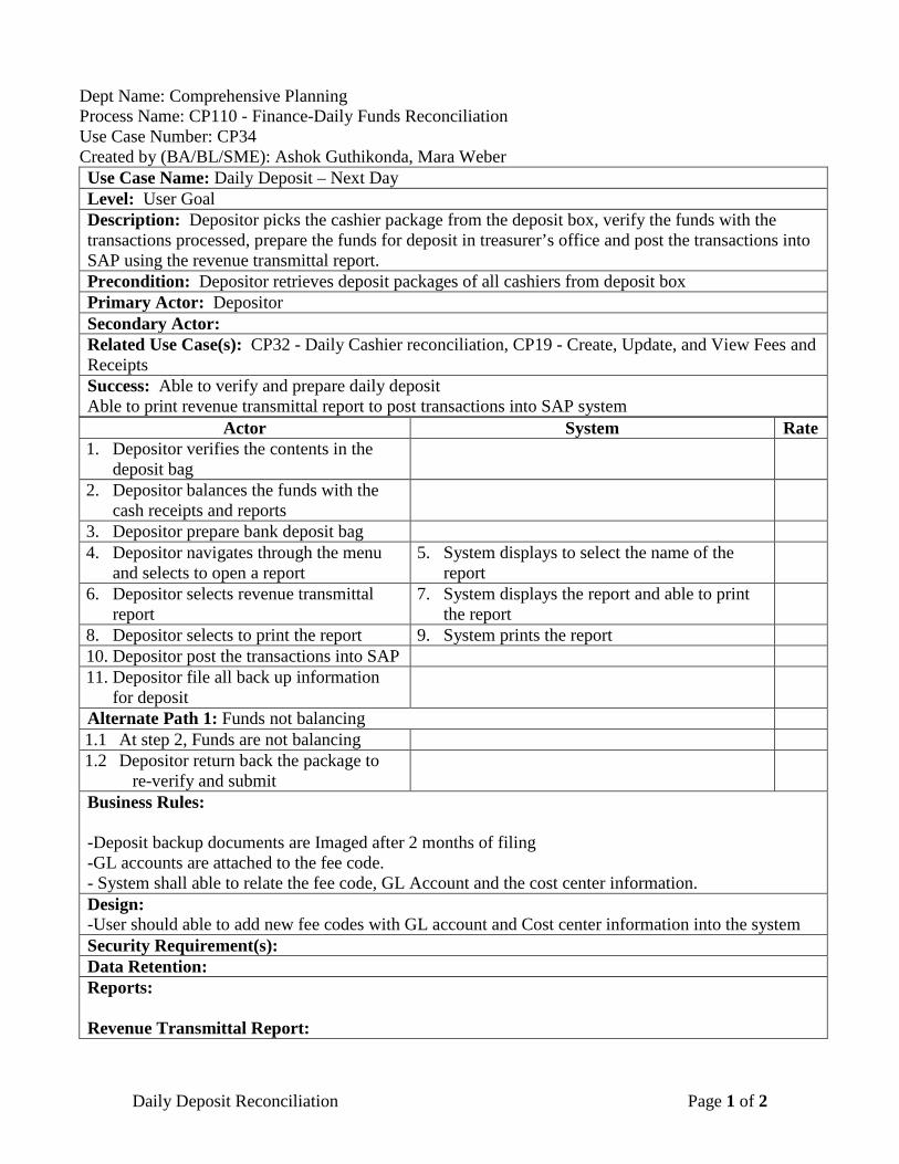
Dept Name: Comprehensive Planning Process Name: CP110 - Finance-Daily Funds Reconciliation Use Case Number: CP34 Created by (BA/BL/SME): Ashok Guthikonda, Mara Weber Use Case Name: Daily Deposit – Next Day Level: User Goal Description: Depositor picks the cashier package from the deposit box, verify the funds with the transactions processed, prepare the funds for deposit in treasurer’s office and post the transactions into SAP using the revenue transmittal report. Precondition: Depositor retrieves deposit packages of all cashiers from deposit box Primary Actor: Depositor Secondary Actor: Related Use Case(s): CP32 - Daily Cashier reconciliation, CP19 - Create, Update, and View Fees and Receipts Success: Able to verify and prepare daily deposit Able to print revenue transmittal report to post transactions into SAP system
Actor System Rate 1. Depositor verifies the contents in the
deposit bag
2. Depositor balances the funds with the cash receipts and reports
3. Depositor prepare bank deposit bag 4. Depositor navigates through the menu
and selects to open a report 5. System displays to select the name of the
report
6. Depositor selects revenue transmittal report
7. System displays the report and able to print the report
8. Depositor selects to print the report 9. System prints the report 10. Depositor post the transactions into SAP 11. Depositor file all back up information
for deposit
Alternate Path 1: Funds not balancing 1.1 At step 2, Funds are not balancing 1.2 Depositor return back the package to
re-verify and submit
Business Rules: -Deposit backup documents are Imaged after 2 months of filing -GL accounts are attached to the fee code. - System shall able to relate the fee code, GL Account and the cost center information. Design: -User should able to add new fee codes with GL account and Cost center information into the system Security Requirement(s): Data Retention: Reports: Revenue Transmittal Report:
Daily Deposit Reconciliation Page 1 of 2

Report Header Report Name (Comprehensive Planning Revenue Transmittal Report)
Text
Deposit Date Date Date on which funds are deposited
Date of work Date Date the funds were collected Total Deposit Currency Location No Number Unique department identifier
from the bank Report Body Cost Center Number Income Account Number GL Account number Amount Currency Total amount collected against
the GL account and to the cost center
Description of revenue Text Fee description
Comments:
Daily Deposit Reconciliation Page 2 of 2
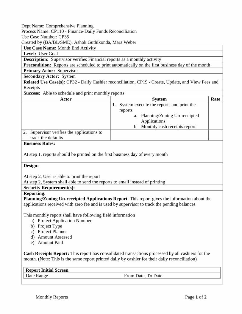
Dept Name: Comprehensive Planning Process Name: CP110 - Finance-Daily Funds Reconciliation Use Case Number: CP35 Created by (BA/BL/SME): Ashok Guthikonda, Mara Weber Use Case Name: Month End Activity Level: User Goal Description: Supervisor verifies Financial reports as a monthly activity Precondition: Reports are scheduled to print automatically on the first business day of the month Primary Actor: Supervisor Secondary Actor: System Related Use Case(s): CP32 - Daily Cashier reconciliation, CP19 - Create, Update, and View Fees and Receipts Success: Able to schedule and print monthly reports
Actor System Rate 1. System execute the reports and print the
reports a. Planning/Zoning Un-receipted
Applications b. Monthly cash receipts report
2. Supervisor verifies the applications to track the defaults
Business Rules: At step 1, reports should be printed on the first business day of every month Design: At step 2, User is able to print the report At step 2, System shall able to send the reports to email instead of printing Security Requirement(s): Reporting: Planning/Zoning Un-receipted Applications Report: This report gives the information about the applications received with zero fee and is used by supervisor to track the pending balances This monthly report shall have following field information
a) Project Application Number b) Project Type c) Project Planner d) Amount Assessed e) Amount Paid
Cash Receipts Report: This report has consolidated transactions processed by all cashiers for the month. (Note: This is the same report printed daily by cashier for their daily reconciliation) Report Initial Screen Date Range From Date, To Date
Monthly Reports Page 1 of 2

Report Body Header Report Name Text Name of the report Date and Time stamp Date/Time Date and time the
report is generated Date Range Date Between dates that
transactions are showing
Line Fee Description Text Fee type Code Text Fee Code Count Number Count of the
transactions Total Collected Currency Total amount by each
fee code Grand Total Currency Total of all “count”
column and total of “total collected” column
Search Criteria: Comments:
Monthly Reports Page 2 of 2