Embed Size (px)
Citation preview

Department of Commerce ▪ National Oceanic & Atmospheric Administration ▪ National Weather Service NATIONAL WEATHER SERVICE EASTERN REGION SUPPLEMENT 02-2011
APPLICABLE TO NWSI 10-515 April 10, 2017
Operations and Services Public Weather Services, NWSPD 10-5
WFO Non-Precipitation Weather Products Specification NWSI 10-515
EASTERN REGION NON-PRECIPITATION WEATHER (NPW) PRODUCTS
NOTICE: This publication is available at: http://www.nws.noaa.gov/directives/. OPR: W/ER1x6 (R. Watling) Certified by: W/ER1 (J. Guiney) Type of Issuance: Routine Update
SUMMARY OF REVISIONS: This is a routine update of ER Supplement 02-2011 (Eastern Region Non-Precipitation Weather Products, also known as NPWs). Changes include:
1) Repairing broken hyper-links within the document. 2) Adding details to section 4.b to make the heat warning program more effective. 3) Increasing typical heat watch and warning lead times in Appendix A. 4) Adding heat advisory and warning threshold maps to the document in Appendix C. 5) Adjusted heat advisory and warning thresholds for western Virginia and eastern West
Virginia in Appendix C.
< signed > ____________________________ _04/10/2017_______ Jason P. Tuell Date Director, NWS Eastern Region
NWS ERS 02-2011, Apr 10, 2017
2
Table of Contents Page
1. Purpose ……………………………………………………………………………. 2 2. Products Types, Trigger Probabilities and Typical Time Horizons ….………..…. 2 3. Relationship to Other Products…………………………………………………… 3 4. Procedures ……………………………………………………………………….. 4 5. Product Format …………………………………………………………………... 6 6. Appendix A – Warning, Watch and Advisory Criteria Table…………………… A1 7. Appendix B – Normal Growing Season Map for Eastern Region ………………. B1 8. Appendix C – Heat Advisory and Excessive Heat Warning Thresholds ………… C1
1. Purpose. This supplement adds detail to baseline national guidance on how to issue
outlooks, watches, warnings and advisories for non-precipitation type weather (NPW) phenomena (wind, temperature and visibility) in Eastern Region (ER).
ER Weather Forecast Offices (WFOs) will issue NPW products when conditions are expected to meet or exceed established criteria posing a threat within their County Warning Area (CWA). NPW products may also be issued for conditions falling short of established criteria when, in the forecaster’s judgment, significant impacts will occur. Weather not meeting hazardous criteria or causing significant impacts should be addressed in other products such as the Short Term Forecast (AWIPS header NOW) or Special Weather Statement (AWIPS header SPS). See: NWSI 10-517, Multipurpose Weather Products Specification and Eastern Region Supplement 02-200, Hazardous Weather Outlook, Special Weather Statement and Short-Term Forecasts at: http://www.nws.noaa.gov/directives/sym/pd01005017e022007curr.pdf for more details.
2. Product Types, Trigger Probabilities and Typical Time Horizons. Non-precipitation
hazards are handled using two different product types – the Hazardous Weather Outlook (HWO) and the NPW. The following trigger probabilities and time horizons apply:
a. Outlooks. Hazards are mentioned in the HWO product affecting all or part of the CWA, when the probability of the hazard meeting/exceeding warning and/or impact criteria is 30-49%.
b. Watches. Non-Precipitation watches are issued using the NPW product for hazards
expected to affect all or part of the CWA, when there is a 50-79% chance of meeting or exceeding warning or impact criteria.
c. Warnings. Non-Precipitation warnings are issued using the NPW product for hazards expected to affect all or part of the CWA, when there is an 80% or greater chance of meeting or exceeding warning or impact criteria; this typically occurs 12 to 24 hours prior to criteria being met. In rare situations, when the uncertainty of

NWS ERS 02-2011, Apr 10, 2017
3
meeting criteria is still below 80% within 12 hours of storm onset, forecasters should issue either a warning or advisory to end the indecision.
d. Advisories. Advisories for non-precipitation events are issued using the NPW product for those events expected to cause inconvenience, and if caution is not exercised, may lead to life-threatening situations over all or part of the forecast area. WFOs should issue advisories when there is an 80% or greater chance of impacts occurring; typically 12 to 24 hours before they begin. In rare situations, when the uncertainty of having impacts is still below 80% within 12 hours of storm onset, forecasters should issue either a warning or advisory to end the indecision.
3. Relationship to other Products. a. Winter Weather Message (WSW). When precipitation and non-precipitation weather hazards are expected to occur simultaneously within a storm, combined phenomena can be handled using a single product. To decide which product to choose (WSW or NPW) use the following hierarchal rules:
1. Choose the product type with the highest alert level (warning trumps advisory), and 2. If all the alert levels are the same, choose the WSW over the NPW.
b. Severe Thunderstorm Warning (SVR). There will be times, particularly in the spring and autumn, when convective cells are embedded in moderately intense synoptic scale wind regimes. While these convective cells may not develop into thunderstorms, their downdrafts are strong enough to push the gradient wind field into advisory or warning categories. In such cases, sound forecaster judgment ultimately determines which product is used (NPW, SVR or SPS).
The following general guidelines (using a time-filter rather than a spatial one) are offered to assist forecasters in handling wind situations only (i.e., no large hail expected). If the convective wind event is expected to equal or exceed warning values for one hour or more, then an NPW (High Wind Warning) is recommended. If less than one hour, a SVR (Severe Thunderstorm Warning) is recommended, even if lightning is not observed within convective elements. If the convective wind event is expected to fall within the advisory category for one hour or more, then an NPW (Wind Advisory) is recommended. If less than one hour, an SPS (no headline required) is recommended. When short-lived, significant convective gusts > 64 knots are expected within an area already covered by a High Wind Warning, the forecaster should issue a SVR in addition to the NPW to highlight and emphasize the specific high-end threat.

NWS ERS 02-2011, Apr 10, 2017
4
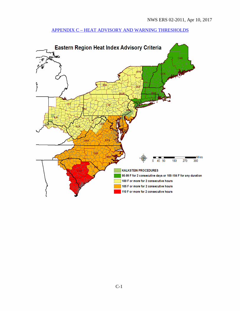
c. Air Quality Alerts. ER WFOs that have event-driven air quality alerts in cooperation with state and local air quality officials will issue these products under the AWIPS header AQA. See Directive 10-519 for details. 4. Procedures. ER offices are required to issue watches, warnings and advisories when the probability of meeting an event’s criteria reaches established thresholds. However, warnings and advisories may be issued for conditions falling short of established criteria when, in the forecaster’s judgment, lives or property will be at risk. Forecasters should make every reasonable effort to collaborate with adjacent offices to reach consensus on event type, timing and magnitude. a. Wind. Local policy should be used to determine whether High Wind Watches, Warnings or Wind Advisories are needed for climatologically windy locations. For example, Mt. Washington routinely experiences winds within the advisory category and frequently within the warning category. Some coastal channels, valleys and mountain passes have similar conditions. Locally established criteria above regional values based on climatology are acceptable in those geographic areas. The following ER WFOs will issue “regular” (non-tropical) NPWs for high wind watches/warnings when winds from hurricane/tropical storms move into their area of responsibility: BGM, BTV, BUF, CAE, CLE, CTP, GSP, ILN, PBZ, RAH, RLX and RNK. (When any of these offices are in backup mode for a coastal WFO, the guidance provided in the next paragraph applies.) Coastal WFOs will issue hurricane/tropical storm watches and warnings for their inland counties via TCVs, for winds of tropical cyclone origin. (Note: Due to their relatively small size, all of Connecticut and Massachusetts are included in hurricane/tropical storm watches and warnings – coastal counties are NHC-issued with inland counties WFO-issued. Thus, WFO ALY will issue regular (non-tropical) NPWs for all of its counties EXCEPT Berkshire, MA and Litchfield, CT, which will be handled via the TCV to issue hurricane/tropical storm watches for winds.) b. Heat. Emergency department visits begin well before NWS thresholds are met, thus forecasters should focus on issuing long-lead watches along with early, enhanced safety messaging to partners and customers via Public Information Statements and social media. Heat related criteria can be found in Appendix C of this document. c. Freeze and Frost. Temperatures at or below 32°F can adversely affect outdoor operations (e.g. gardening). The probability of freezing temperatures occurring varies by location and time of year; this variation causes uncertainty as to when a WFO’s freeze/frost program should begin and end. Maps by NWS zones based on National Climatic Data Center files and WFO adjustments are available in Appendix B to help establish coordinated start and stop dates for this program.
NWS ERS 02-2011, Apr 10, 2017
5
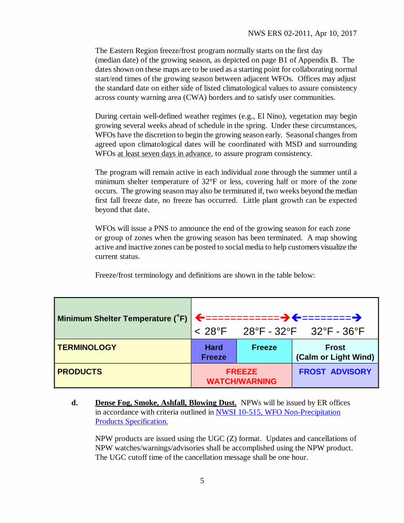
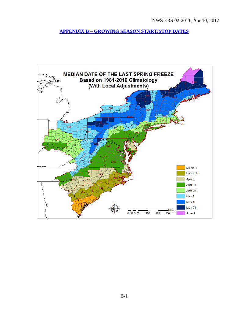
The Eastern Region freeze/frost program normally starts on the first day (median date) of the growing season, as depicted on page B1 of Appendix B. The dates shown on these maps are to be used as a starting point for collaborating normal start/end times of the growing season between adjacent WFOs. Offices may adjust the standard date on either side of listed climatological values to assure consistency across county warning area (CWA) borders and to satisfy user communities.
During certain well-defined weather regimes (e.g., El Nino), vegetation may begin growing several weeks ahead of schedule in the spring. Under these circumstances, WFOs have the discretion to begin the growing season early. Seasonal changes from agreed upon climatological dates will be coordinated with MSD and surrounding WFOs at least seven days in advance, to assure program consistency.
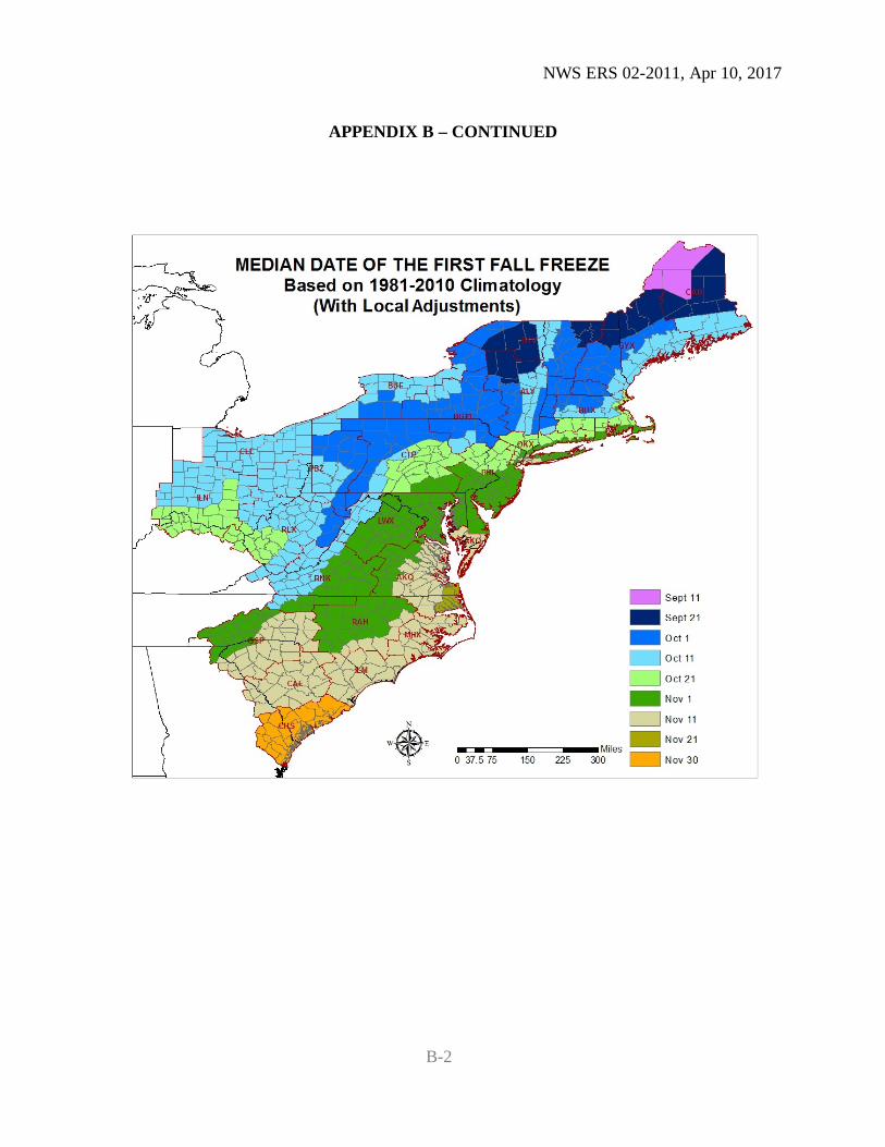
The program will remain active in each individual zone through the summer until a
minimum shelter temperature of 32°F or less, covering half or more of the zone occurs. The growing season may also be terminated if, two weeks beyond the median first fall freeze date, no freeze has occurred. Little plant growth can be expected beyond that date.
WFOs will issue a PNS to announce the end of the growing season for each zone
or group of zones when the growing season has been terminated. A map showing active and inactive zones can be posted to social media to help customers visualize the current status.
Freeze/frost terminology and definitions are shown in the table below:
d. Dense Fog, Smoke, Ashfall, Blowing Dust. NPWs will be issued by ER offices in accordance with criteria outlined in NWSI 10-515, WFO Non-Precipitation Products Specification.
NPW products are issued using the UGC (Z) format. Updates and cancellations of NPW watches/warnings/advisories shall be accomplished using the NPW product. The UGC cutoff time of the cancellation message shall be one hour.
Minimum Shelter Temperature (°F) ==================== < 28°F 28°F - 32°F 32°F - 36°F
TERMINOLOGY Hard Freeze
Freeze Frost (Calm or Light Wind)
PRODUCTS FREEZE WATCH/WARNING
FROST ADVISORY
NWS ERS 02-2011, Apr 10, 2017
6
5. Product Format. NPWs are segmented products. Format requirements can be found at: NWSI 10-515, WFO Non-Precipitation Products Specification. Some additional notes are provided below: a. Elevation. ER WFOs may include elevation in the headline as necessary. If used,
elevation information will be included at the end of the headline. For example, “...HIGH WIND WARNING IN EFFECT UNTIL 6 AM TUESDAY ABOVE 1000 FEET...”
b. Expiration Statements. Though not specifically addressed in NWSI 10-515, ER
WFOs are encouraged to issue a final statement when a warning or advisory has reached its normal expiration time and has not been previously canceled. A short statement should be issued near the expiration time with the headline “THE WARNING/ADVISORY HAS EXPIRED”, or “THE WARNING/ADVISORY WILL EXPIRE AT...” This provides customers with final notification that the event is over.
c. Attribution Statement. An attribution statement (THE NATIONAL WEATHER
SERVICE IN [WFO LOCATION] HAS ISSUED A...) is required for the first issuance of any watch/warning/advisory, to be located between the headline and bullet sections (see examples in NWSI 10-515, WFO Non-Precipitation Products Specification, Appendix A).
d. Bullet Content. Each bullet of the warning will be concise and restricted to
addressing the specific weather expected, timing, preparedness actions to take, etc. As appropriate, include mention of geographic locations where the public will be especially vulnerable (e.g. interstate highways through mountain passes) in the impacts section. The definition of a watch/warning must be included in the precautionary/preparedness section as shown in NWSI 10-515, WFO Non-Precipitation Products Specification, Appendix A. Call-to-action statements should also be included in the precautionary/preparedness bullet.
NWS ERS 02-2011, Apr 10, 2017
A-1
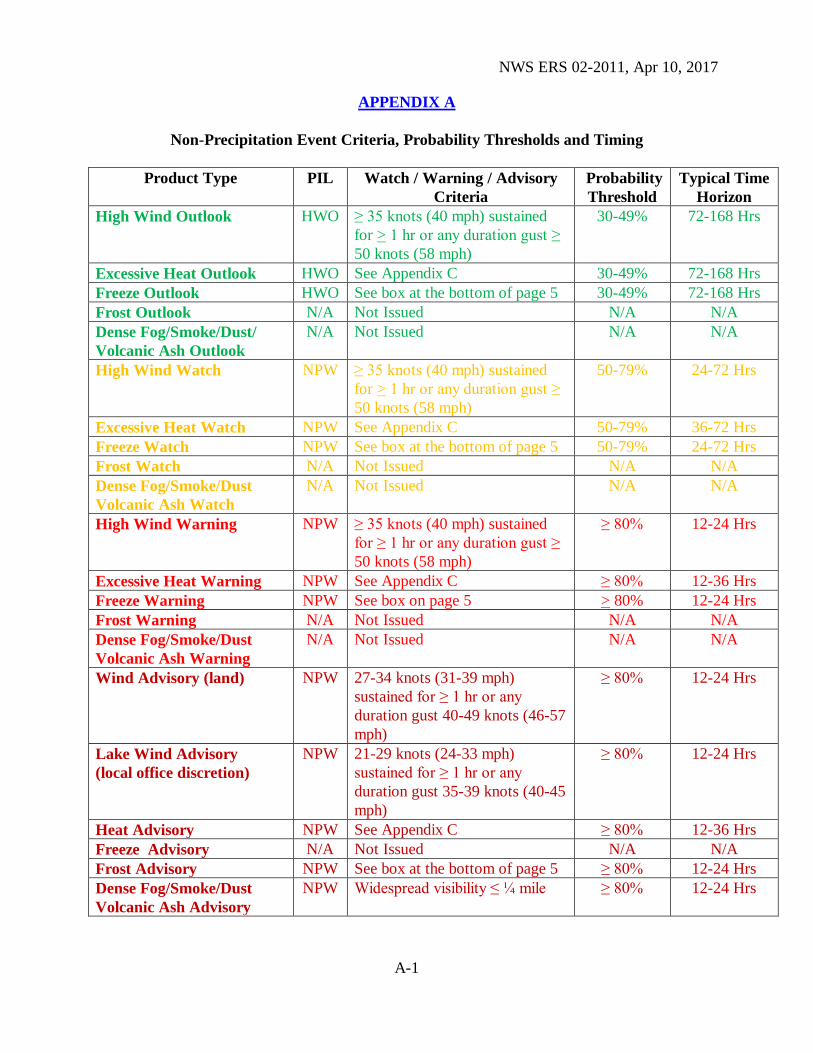
APPENDIX A
Non-Precipitation Event Criteria, Probability Thresholds and Timing
Product Type PIL Watch / Warning / Advisory Criteria
Probability Threshold
Typical Time Horizon
High Wind Outlook HWO ≥ 35 knots (40 mph) sustained for > 1 hr or any duration gust ≥ 50 knots (58 mph)
30-49% 72-168 Hrs
Excessive Heat Outlook HWO See Appendix C 30-49% 72-168 Hrs Freeze Outlook HWO See box at the bottom of page 5 30-49% 72-168 Hrs Frost Outlook N/A Not Issued N/A N/A Dense Fog/Smoke/Dust/ Volcanic Ash Outlook
N/A Not Issued N/A N/A
High Wind Watch NPW ≥ 35 knots (40 mph) sustained for > 1 hr or any duration gust ≥ 50 knots (58 mph)
50-79% 24-72 Hrs
Excessive Heat Watch NPW See Appendix C 50-79% 36-72 Hrs Freeze Watch NPW See box at the bottom of page 5 50-79% 24-72 Hrs Frost Watch N/A Not Issued N/A N/A Dense Fog/Smoke/Dust Volcanic Ash Watch
N/A Not Issued N/A N/A
High Wind Warning NPW ≥ 35 knots (40 mph) sustained for ≥ 1 hr or any duration gust ≥ 50 knots (58 mph)
≥ 80% 12-24 Hrs
Excessive Heat Warning NPW See Appendix C ≥ 80% 12-36 Hrs Freeze Warning NPW See box on page 5 > 80% 12-24 Hrs Frost Warning N/A Not Issued N/A N/A Dense Fog/Smoke/Dust Volcanic Ash Warning
N/A Not Issued N/A N/A
Wind Advisory (land) NPW 27-34 knots (31-39 mph) sustained for ≥ 1 hr or any duration gust 40-49 knots (46-57 mph)
≥ 80% 12-24 Hrs
Lake Wind Advisory (local office discretion)
NPW 21-29 knots (24-33 mph) sustained for ≥ 1 hr or any duration gust 35-39 knots (40-45 mph)
≥ 80% 12-24 Hrs
Heat Advisory NPW See Appendix C ≥ 80% 12-36 Hrs Freeze Advisory N/A Not Issued N/A N/A Frost Advisory NPW See box at the bottom of page 5 ≥ 80% 12-24 Hrs Dense Fog/Smoke/Dust Volcanic Ash Advisory
NPW Widespread visibility ≤ ¼ mile ≥ 80% 12-24 Hrs
NWS ERS 02-2011, Apr 10, 2017
B-1
APPENDIX B – GROWING SEASON START/STOP DATES
NWS ERS 02-2011, Apr 10, 2017
C-1
C-1
APPENDIX B – CONTINUED
B-2
NWS ERS 02-2011, Apr 10, 2017
C-1
C-1
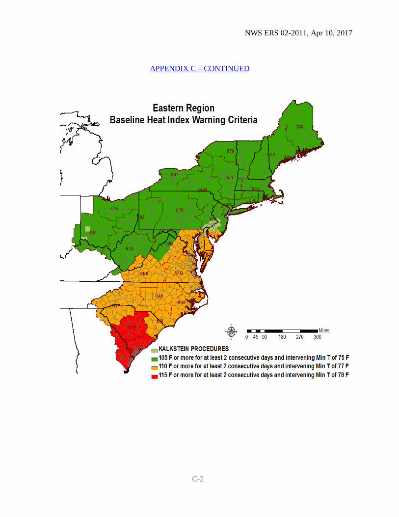
APPENDIX C – HEAT ADVISORY AND WARNING THRESHOLDS
NWS ERS 02-2011, Apr 10, 2017
C-1
C-1
APPENDIX C – CONTINUED
C-2