Embed Size (px)
Citation preview
1
DEPARTMENT OF GEOPHYSICS KURUKSHETRA UNIVERSITY KURUKSHETRA
SCHEME OF EXAMINATION AND SYLLABUS OF M.Tech. (Applied Geophysics). FIRST SEMESTER EFFECTIVE FROM THE SESSION 2013-14: S.No. Course no.& Course Marks Distribution Th/P CW Total Credit
1. GP-101: Mathematical Methods 60 40 100 4 in Geophysics 2. GP-102: Solid Earth Geophysics 60 40 100 4 3. GP-103: Numerical Methods & 60 40 100 4
Computer Programming
4. GP-104: Basic Geology 60 40 100 4 5. GP-105: Geology Lab 60 40 100 6
6. GP-106: Computer Lab 60 40 100 6
Semester Total 600 28
SECOND SEMESTER EFFECTIVE FROM THE SESSION 2013-14: S.No. Course no.& Course Marks Distribution Th/P CW Total Credit
1. GP-201: Remote Sensing & GIS 60 40 100 4 2. GP-202: Stratigraphy, Economic 60 40 100 4 & Petroleum Geology
3. GP-203: Geophysical Signal Processing 60 40 100 4
4. GP-204: Geophysical Fields & Waves 60 40 100 4 5. GP-205: Geophysical Lab - I 60 40 100 6
6. GP-206: Geophysical Lab - II 60 40 100 6
7. GP-207: Geological Field Training 100 4
Semester Total 700 32
2
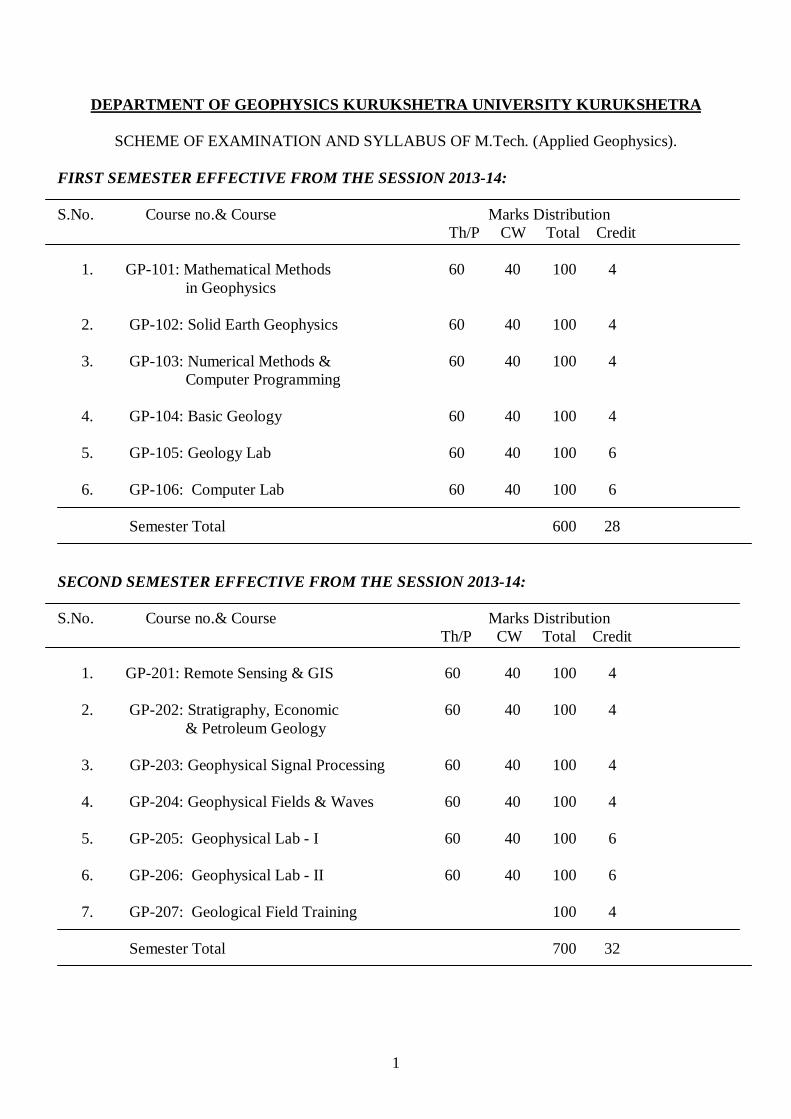
THIRD SEMESTER EFFECTIVE FROM THE SESSION 2013-14: S.No. Course no.& Course Marks Distribution Th/P CW Total Credit
1. GP-301: Seismology 60 40 100 4 2. GP-302: Gravity & Magnetic Prospecting 60 40 100 4 3. GP-303: Groundwater Geophysics 60 40 100 4
4. GP-304: Electrical Prospecting 60 40 100 4 5. GP-305: Geophysical Lab-III 60 40 100 6
6. GP-306: Geophysical Lab-IV 60 40 100 6
7. GP-307: Geophysical Field Training-I 100 4
Semester Total 700 32
FOURTH SEMESTER EFFECTIVE FROM THE SESSION 2013-14: S.No. Course no.& Course Marks Distribution Th/P CW Total Credit
1. GP-401: Petrophysics & Well Logging 60 40 100 4
2. GP-402: Physical Oceanography & 60 40 100 4 Marine Geophysics 3. GP-403: Seismic Prospecting 60 40 100 4
4. GP-404: Geophysical Inversion 60 40 100 4
5. GP-405: Geophysical Lab – V 60 40 100 6 6. GP-406: Geophysical Lab - VI 60 40 100 6
Semester Total 600 28
3
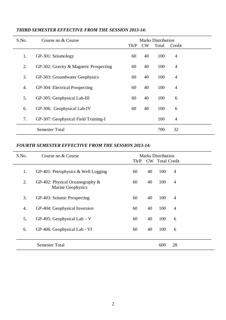
FIFTH SEMESTER EFFECTIVE FROM THE SESSION 2013-14: S.No. Course no.& Course Marks Distribution Th/P CW Total Credit
1. GP-501: Near Surface Geophysics 60 40 100 4
2. GP-502: Electromagnetic and 60 40 100 4 Magenotelluric Methods
3. GP-503: Geophysical Lab-VII 60 40 100 6
4. GP-504: Geophysical Lab-VIII 60 40 100 6
5. GP-505: Geophysical Field Training-II 100 4 6. GP- Elective – I 60 40 100 4
7. GP- Elective – II 60 40 100 4
Semester Total 700 32
SIXTH SEMESTER EFFECTIVE FROM THE SESSION 2013-14: S.No. Course no.& Course Marks Distribution Total Credit
1. GP-601: Dissertation 400 16
2. GP- 602: Comprehensive Viva-Voce 100 4 3. GP- 603: Seminar 100 4
Semester Total 600 24
4
Elective – I Solid Earth GP-506 : Computational Seismology GP-507: Geomagnetism GP-508: Whole Earth Dynamics GP-509: Solid Mechanics GP-510: Numerical Simulation of Earth System GP-511: Non-linear Geophysics Elective – II GP-512: Geotomography GP-513: Seismic Data Analysis & Reservoir Geophysics GP-514: Reservoir Modelling GP-515: Radiometric Exploration GP-516: Advanced Remote Sensing & Image Processing
5
GP-101: Mathematical Methods in Geophysics
Max. Marks: 60 Credits : 4 Time: 3 hours Special Notes: (i) Nine questions will be set and students will attempt five questions. Question no. I will be compulsory and based on the conceptual aspects of the whole syllabus. It can have 5 to 10 parts. The answers should not be in yes/no. In addition to question no. I, there will be four units in the question paper each containing two questions belonging to four units in the syllabus. Students will select one question from each unit. UNIT-I: Special Functions Power series. Bessel’s and Legendre’s differential equations and their series solutions. Properties of Bessel functions and Legendre polynomials Legendre functions: Generating functions, Rodrigue’s formula, Recurrence relations, Orthogonality, Associated Legendre functions and its recurrence relations and orthogonality property. Bessel Functions: Generating functions, Recurrence relations, Orthogonality, Expressions when ‘n’ is half an odd integer, Spheraical Bessel functions. Applications of Legendre and Bessel functions in geophysics UNIT-II: Complex Variables Complex variable, limit, continuity and differentiability of function of complex variables, analytic functions, Cauchy Reimann’s equations, Cauhy’s integral theorem, Morera’s theorem, Cauchy integral formula, Expansion by Taylors and Laurents series, singularities, Residue theorem, contour integration. Applications in geophysics Unit-III: Integral Transforms Fourier series, Fourier transform, inverse Fourier transform, properties of Fourier transform, Parseval’s Theorem, application of Fourier transform in solving differential equations. Laplace transform, Inverse Laplace transform, Convolution theorem, Properties of Laplace transform, application of Laplace transform in solving differential equations. A brief introduction to Hankel, Hilbert and Radon transforms. Applications in geophysics Unit-IV: Partial Differential Equations Solution by separation of variables of (a) Wave equation: Transverse vibrations of a stretched string; Oscillations of a hanging chain, vibrations of rectangular and circular membrances, tidal waves in a canal. (b) Laplace’s equation: Laplace equation in Cartesian, Cylindrical and spherical coordinate systems, two dimensional steady flow of heat, General cylindrical and spherical harmonics. (c) Diffusion equation: Variable linear heat flow, periodic heat flow in one dimension, two dimensional heat conduction. RECOMMENDED BOOKS (1) Applied Mathematics for Engineers and Physicists by L .Pipes & L.R. Horwell (2) Mathematical Methods for Physicists by G. Arfken (3) Mathematical Physics by B.S. Rajput (4) Elementrary Applied Partial Differential Equations: With Fourier Series and Boundary Value Problems by Richard Haberman (5) Integral Transforms by I. Sneddon (6) Elements of Partial Differential Equations by I. Sneddon
6
GP-102: Solid Earth Geophysics
Max. Marks: 60 Credits : 4 Time: 3 hours
Special Notes: Nine questions will be set and students will attempt five questions. Question no. I will be compulsory and based on the conceptual aspects of the whole syllabus. It can have 5 to 10 parts. The answers should not be in yes/no. In addition to question no. I, there will be four units in the question paper each containing two questions belonging to four units in the syllabus. Students will select one question from each unit.
UNIT-I A brief history of the development of Earth Sciences and of Geophysics in particular, An overview of Geophysical methods and their essential features, Problems of inversion and non-uniqueness in Geophysics, Origin & evolution of Solar system, Earth and Moon structure,. Kepler's law of planetary motion, A review of the Earth’s structure and composition UNIT-II Chemical composition of Earth, Rheological behaviour of crust and upper mantle, viscoelasticity and rock failure criteria, Geochronology: Radiometric dating and their advantages, meaning of radiometric ages, Major features of the Earth’s gravitational field and relationship with tectonic processes in the crust and upper mantle, concept of isostasy, mathematical concept of Airy and Pratt hypotheses of isostasy. UNIT-III Origin of geomagnetic field, polar wandering, secular variations and westward drift, reversals of geomagnetic field, sun spot, solar flares, geomagnetic storms, sea-floor spreading, Paleomagnetism and its uses, Thermal history of the Earth, sources of heat generation and temperature distribution inside the earth, convection in the mantle. UNIT-IV Earthquake seismology, Earthquakes and its classifications, Global seismicity and tectonics, Earth’s internal structure derived from seismology, Earthquake mechanism and Anderson’s theory of faulting, Continental drift and plate tectonics: its historical perspective and essential features, present day plate motions, Triple junctions, oceanic ridges, Benioff zones, trenches and island arcs, hot spots, Mantle Plume, Mountain building, origin of Himalaya, Geodynamics of Indian subcontinent. RECOMMENDED BOOKS: (1) The Solid Earth by C.M.R. Fowler (2) Understanding the Earth by I.G. Guass, P.S. Smith and R.G.L. Wilson (3) The dynamic Earth by P.J. Wyllie (4) Introduction to Geophysics by B.F. Howell (5) Physics and Geology by J.J. Jacobs, R.D. Russel and J.T. Klilson (6) Fundamental of Geodynamics by A.E. Schieddeggar (7) Fundamentals of Geophysics by W. Lowrie
7
GP-103: NUMERICAL METHODS AND COMPUTER PROGRAMMING Max. Marks: 60 Credits : 4 Time: 3 hours Special Notes: (i) Nine questions will be set and students will attempt five questions. Question no. I will be compulsory and based on the conceptual aspects of the whole syllabus. It can have 5 to 10 parts. The answers should not be in yes/no. In addition to question no. I, there will be four units in the question paper each containing two questions belonging to four units in the syllabus. Students will select one question from each unit. UNIT-I Basic computer organization, information storage media, computer software, computer languages, problem solving on a computer, algorithm, flowchart and computer program, introduction to computer operating systems: DOS, WINDOWS, UNIX/LINUX, concept of SHELL programming, introduction about MATLAB. UNIT-II FORTRAN preliminaries, constants, variables, data types, expression and statements, iterative statements, input/output statements, subroutine and functions, data sharing among subprograms/programs, operations with files, programming examples to handle problems of numerical and statistical type UNIT-III Programming language C: constants, variables, data types, expressions, operators, conditional statements, iterative statements, array, function, simple programming examples C++ An object oriented language: Concepts of class, object, constructors, destructors, operator overloading, inheritance, pointers, virtual functions, simple programming examples UNIT-IV Numerical integration by Simpson’s method, Trapezoidal method, Numerical differentiation, solution of algebraic equation, Netwon Raphson method, solution of simultaneous linear equations, Gauss method, Gauss-Jordon method, Gauss-Seidel method, matrix inversion, least square curve fitting, straight line and polynomial fits, solution of ordinary differential equations. A brief introduction of Binomial, Poisson and normal distributions, concept of mathematical expectations RECOMMENDED BOOKS
(1) Fundamentals of computers by V. Rajaraman (2) FORTRAN 77 and Numerical methods by C. Xavier (3) FORTRAN Programming and Numerical methods by R.C. Desai (4) Let us C by Yashwant Kanetkar (5) Object Oriented programming with C++ by E. Balagurusamy (6) Advanced UNIX- A Programmers guide by Stephen Prata
8
GP-104: BASIC GEOLOGY Max. Marks: 60 Credits : 4 Time: 3 hours Special Notes: (i) Nine questions will be set and students will attempt five questions. Question no. I will be compulsory and based on the conceptual aspects of the whole syllabus. It can have 5 to 10 parts. The answers should not be in yes/no. In addition to question no. I, there will be four units in the question paper each containing two questions belonging to four units in the syllabus. Students will select one question from each unit. UNIT – I: INTRODUCTION Introduction to geology, scope, sub-disciplines and relationships with other branches of science, Geomorphological Processes: Exogenic processes (weathering, erosive and tectonic denudation), Geologic time and age of the Earth, Geological processes by river, wind, glacier and waves and tides. Orogeny, volcanism, earthquakes and land slides UNIT – II: MINERALOGY Mineral – its definition and mode of occurrence, physical properties of minerals like form, colour, lustre, streak, cleavage, fracture, hardness and specific gravity, radioactivity, isotopes and ions, Physical characters and chemical composition of the rock forming minerals, mode of occurrence and economic uses of some important rock forming minerals. UNIT – III: PETROLOGY Rock- its definition, classification and distinguishing characteristics of Igneous, Sedimentary and Metamorphic rocks. Igneous rocks: Magma and lava, extrusive and intrusive forms, textures; Classification and description of some common igneous rocks (Granite, Dolerite, Basalt, Rhyolite, Pegmatite). Sedimentary rocks: Sedimentation processes; Classification and description of some common sedimentary rocks (Conglomerate, Sandstone, Shale, Limestone). Metamorphic rocks: Processes of metamorphism, textures and structures of metamorphic rocks; Classification and description of some common metamorphic rocks (Slate, Schist, Gneiss, Quartzite, Marble). Indian distribution of major rock types. UNIT – IV: STRUCTURAL GEOLOGY Primary and secondary structures of rock, Dip, strike, bearing and azimuth, Outcrops, outliers and inliers, Folds: definition and classification scheme, mechanism of folding, recognisation of folds in the field. Fault: definition and different terminology of fault, mechanism of faulting, recognisation of fault in the field, shear zone, lineament. Joints: definition, types of joint. Unconformity: concepts, types, recognisation and significance of unconformities. Clinometer compass and its use. RECOMMENDED BOOKS:
(1) Rutley’s Elements of Mineralogy By H.H. Read (2) Structural Geology by M.P. Billings (3) Principles of Physical Geology by A.H. Holmes (4) A Text Book of Geology by P.K. Mukherjee (5) The Principles of Petrology by G.W. Tyrrell (6) Manual of Field Geology by R.R Compton

9
GP-105: GEOLOGY LAB
Max. Marks: 60 Credits : 6 Time: 4 hours
1. Continental scale land forms of India
2. Physical properties of important rock forming minerals
3. Megascopic study and identification of important igneous, sedimentary and metamorphic rocks
4. Study of Toposheets
5. Uses of bruntone/clinometer and measurement of dip and strike of beds
6. Study of geological map and construction of cross section of area comprising of horizontal,
unconformable, inclined, folded and faulted rocks.
10
GP-106: COMPUTER LAB
Max. Marks: 60 Credits : 6 Time: 3 hours
(1) Exposure to computer operating system : DOS, WINDOWS, UNIX/LINUX
(2) Simple exercises based on available computer softwares
(3) Programming exercises on computational problems and their solution on computers. These
include the following:
(i) Matrix operations
(ii) Matrix inversion
(iii) Numerical integration
(iv) Solution of simultaneous equations
(v) Linear curve fitting
(vi) Correlation coefficient, standard deviation etc.
(vii) Numerical differentiation
(viii) Solution of differential equation
(ix) Solution of transcendental and algebraic equation using Newton Raphson method
11
GP-201: Remote Sensing and GIS
Max. Marks: 60 Credits : 4 Time: 3 hours Special Notes: (i) Nine questions will be set and the students will attempt five questions. Question No.1 will be compulsory and based on the conceptual aspects of the whole syllabus. It can have five to ten parts. Answers should not be in yes/no. In addition to question No. 1, there will be four units in the question paper each containing two questions belonging to four units in the syllabus. Students will select one question from each unit. Unit I Definition, Principle and Physical basis of Remote Sensing, Electromagnetic (EM) Spectrum, Interaction of EM radiations with earth’s surface and atmosphere, Atmospheric Windows, spectral signatures, remote sensing platforms, Concept of Photogrammetry, aerial photographs, types of aerial photographs, Information recorded on aerial photographs, stereoscopy, stereoscopic parallax, measurement of height difference, vertical exaggeration, elements of photo-interpretation, geotechnical elements, photo-characteristics of different rock types, photo-mosaic, image distortion and rectification. Unit II Remote Sensing Sensors: active and passive sensors, Satellite Imagery: Imagery vis a vis aerial photograph, MSS, LISS, CCD, Infrared and thermal scanners, IRS, SPOT and LANDSAT satellite programmes, microwave remote sensing: RADAR, LIDAR etc, remote sensing data products, resolutions in remote sensing, multispectral, super-spectral and hyper-spectral remote sensing, fundamentals of image interpretations and analysis, visual interpretation of remote sensing data; colour composites, concept of digital image and pixels, image restoration, image enhancement and information extraction, supervised and unsupervised classification; accuracy assessment in remote sensing Unit III Introduction to Geographical Information System (GIS), components of GIS, functions of GIS, data structures, Concept of raster and vector data, digitization, editing, attribute attachment etc, creation of thematic layers, Data Integration, vector to raster conversion and vice –versa. Introduction to Global Position System (GPS), various segments of GPS, Uses of GPS. Unit IV Applications of Remote Sensing and GIS: image interpretation for identification of different rock types, structures, lineaments and preparation of geological map; recognition of landforms and preparation of geomorphological map; drainage pattern and its significance; ground water prospects mapping, integrated ground water resources (IGWR) mapping, landslide hazard zonation, route alignment for road/ canal, Hydrocarbon and minerals exploration, Disaster management (flood and cyclones) Recommended Books:
1. Remote Sensing Geology (Springer Verlag). R.P. Gupta 2. Remote Sensing in Geology (John Wiley & sons). B.S. Siegel and A.R. Gillespie 3. Remote Sensing and image interpretation (John Wiley & sons). T.M. Lillesand and R.W. Kiefer 4. Remote Sensing Principles and interpretation (WH Freeman Company. F.F. Reeds 5. Remote Sensing fro Earth Resources (AEG publication), D.P. Rao 6. Principles of Remote sensing (ELBS London). P. J. Kuran 7. Advances in Geophysics Vol. 1 and 13 (Academic press) H.E. Landesberg 8. Handbook of Information issued by GSI (Airborne Mineral surveys and exploration wing), AEC
(Atomic Minerals Divisions) and NGRI.
12
9. Principles of GIS, P. A. Burrough 10. Indian Society of Geomatics News letters 2004-2005 11. GPS: Theory and Practice (Springer Verlag). B. Hofman-wellenhof, H.lichtenegger and J.Collins
13
GP-202 STRATIGRAPHY, ECONOMIC AND PETROLEUM GEOLOGY
Max. Marks: 60 Credits : 4 Time: 3 hours Special Notes: (i) Nine questions will be set and students will attempt five questions. Question no. I will be compulsory and based on the conceptual aspects of the whole syllabus. It can have 5 to 10 parts. The answers should not be in yes/no. In addition to question no. I, there will be four units in the question paper each containing two questions belonging to four units in the syllabus. Students will select one question from each unit. Unit-1 Stratigraphy Introduction, Nomenclature, classification schemes, Geological Time scale and correlation, Basic concepts of sequence Stratigraphy and seismic stratigraphy, Broad out line of the stratigraphic and tectonic features of India, Elements of Precambrian, Palaeozoic, Mesozoic and Cenozoic stratigraphy, Tectonic divisions of Himalaya. Unit-2. Economic Geology Definition of ore, Ore and gangue mineral, Classification of ore deposits, Elementary idea s of the following processes of formation of ore deposits: Magmatic concentration, Pegmatitic, Sedimentation, Evaporation, Residual concentration, Mechanical concentration and Metamorphism, Chemical composition, Diagnostic characters, Occurrences, Uses and Distribution in India of important metallic and non-metallic mineral deposits. Unit-3 Petroleum Geology-I Petroleum; Origin of petroleum; Sedimentary environments and facies; The sources; Migration; The reservoir rocks; Traps and Seals; Exploration processes; Sequence stratigraphy and basin analysis, Classfication of Indian basins and petroleum geology of Assam, Bengal, Cavery, Krishna-Godavari, Cambay and Bombay offshore basins. Unit-4 Petroleum Geology-II Unconvensional Resources: Shale gas; Tar Sands; Coal Bed Methane; Oil Shale; Gas hydrates; Plate tectonics and global distribution of hydrocarbon reserves; The future of petroleum oil industry Recommended Books
1. Economic Geology: Bateman 2. India’s Mineral Resources: Krishna Swami 3. Introduction to India’s Economic Minerals 4. Geology of India and Burma: Krishnan 5. Geology of India: Wadia 6. Geology of Petroleum: Leverson, A.I. 7. Petroleum Geology: Chapman, R.E. 8. Petroleum formation and occurrence Tissot, B.P. and Welte, D.H.
1984., 2nd Edn., Springer-Verlog, Berlin.
14
GP-203: Geophysical Signal Processing Max. Marks 60 Credits : 4 Time 3 Hrs Special Notes: (i) Nine questions will be set and students will attempt five questions. Question No.1 is compulsory and based on the conceptual aspects of the whole syllabus. It can have 5 to 10 parts. The answer should not be in yes and no. In addition to Question 1, there will be four unit question paper each containing two questions belonging to four units in the syllabus. Students will select one question from each unit. UNIT I: Signal and System Signals: Various special signal and classification of signals, orthogonal function, band limited signals, sampling theorem, aliasing effect of sampling on reconstruction of continuous signal from their samples, extrapolation of band limited signals Systems: Classification of Systems, Linear time invariant causal and stable system with continuous and discrete input, minimum phase signals, Hilbert transform UNIT II: Discrete Transform Z transform, properties of Z transform, and the region of convergence, Z transform of causal and non causal sequence, inverse Z transform, Transfer function, Solutions of difference equation using Z-transform, Relation between S-plane and Z-plane Review of Fourier Transform, Introduction to wavelet transform and Walsh transform and their application in geophysics Discrete Fourier transform (DFT), relation between DFT and Z transform, Fast Fourier Transform (FFT), Decimation in time(DIT) and Decimation in frequency (DIF) algorithms, applications of FFT in geophysics, deconvolution, circular convolution, Importance of Windowing, Commonly used windows, cepstral analysis UNIT III: Time series analysis Introduction of stochastic process, autocorrelation and cross correlation, Stationarity, Wide sense stationarity, ergodicity, power spectral density function, Wiener Khinchine theorem, White Gaussian Noise, Wiener Filtering, Matched Filtering UNIT IV: Filters and System Realization Recursive and non-resursive filters, ideal and realizable low pass, band pass and high pass filters, Gibbs phenomenon, IIR filters: design if IIR filter by Bilinear transformation method, Design of Butterworth filters, Characteristics of Chebyshev and elliptic filters, Design of FIR filters using windows. direct and canonical realization scheme, Cascade and paraellel realization scheme. Reccomended Books
1. Signal and Systems, M.L. Meade and C.R.Dillon , Chapman and Hall London 2. Digital Signal Processing, 1975, Oppenheim, A.V. and R.W. Schafer, Prentice Hall, Englewood
Cliffs, New Jersey 3. An Introduction to Statistical Communication Theory, J. B. Thomas, John Wiley, New York 4. Spectral Analysis in Geophysics, 1974, Markus Bath, Elsevier, Amsterdam 5. Signal Analysis, 1977, A. Popoulis, McGraw Hill New York 6. The Fourier Integrala nd its applications, A. Popoullis, , McGraw Hill New York 7. Time Sequence Analysis in Geophysics, 1975, E.R. Kanscwich 8. Digital Signal Processing, A Anand Kumar PHI Learning, New Delhi
15
GP-204: Geophysical Fields and Waves Max. Marks 60 Credits : 4 Time 3 Hrs Special Notes: (i) Nine questions will be set and students will attempt five questions. Question No.1 is compulsory and based on the conceptual aspects of the whole syllabus. It can have 5 to 10 parts. The answer should not be in yes and no. In addition to Question 1, there will be four unit question paper each containing two questions belonging to four units in the syllabus. Students will select one question from each unit. UNIT – I: Potential Field Theory: Introduction to Geophysical fields; Inverse square law of field: Gravity, Magnetostatic and electrostatic, Green’s theorem and Green’s functions, Potential due to an arbitrary source distribution, continuation of potential fields, Dirichlet and Neumann problems. UNIT-II: Thermal Conduction in Earth Heat conduction equation; effect of advection; time scale of conductive heat flow;calculation of simple geotherms in continents; Geological applications of heat conduction in semi-infinite half space: (i) penetration of external heat into the earth due to periodic variation of surface temperature, (ii) instantaneous heating or cooling of semi-infinite half space and its application to cooling of oceanic lithosphere and (iii) thermal and subsidence history of sedimentary basins, Age of Earth on the basis of cooling. UNIT-III: Wave Theory Introductory remarks about seismic and electromagnetic waves, Elastic Waves: Analysis of stress and strain, properties of equilibrium and motion in terms of stresses/displacements for infinitesimal and finite deformation, Generlised Hook’s Law, Isotropy, Aelotropy and Anelasticity. Electromagnetic Waves: Maxwell’s equations, constitutive relations, Plane electromagnetic waves in dielectric and conductor. Kirchoff’s integral theorem and Kirchoff’s solution of diffraction at a slit. UNIT-IV: Oceanography Tidal Waves, driven tidal waves, seiches, geostrophic effect on tidal waves, internal tidal waves, surface waves, permanent waves, waves due to local disturbances, equilibrium theory of tides, dynamic theory of tides. Books Reccomended
(1) Geodynamics applications of continuum Physics to geological problems : Turcotte & Schubert
(2) Interpretation theory in Applied Geophysics: F.S. Grant & G.F. West (3) Electromagnetic theory: J. Stratton (4) Heat conduction: I.R. Ingersoll (5) Solid Earth: C.F. Fowler (6) Fundamentals of Geophysics: W. Lowrie (7) Introduction to theoretical Geophysics: C.B. Officer
16
GP-205: Geophysical Lab-I
Max. Marks: 60 Credits : 6 Time: 3 hours
Section – A
1. Study of rocks from different stratigraphic horizons of peninsular India
2. Study of rocks of different tectonic divisions of the Himalaya
3. Exercise based upon radioactive dating
4. Megascopic study of major ore minerals
5. Calculation of Oil reserves
6. Study of Geological maps and sections of important oil fields of India
7. Exercises on structure contour map
Section – B
1. Preparation of base maps
2. Use of satellite image for identification of linear features.
3. Preparation of land use land cover map
4. Preparation of drainage map
5. Preparation of Geomorphology map
6. Preparation Hydrogeomorphology map
7. Simple exercises on digital image processing

17
GP-206: Geophysical Lab-II
Max. Marks: 60 Credits : 6 Time: 3 hours
Exercises based on
(i) Convolution model in the time & frequency domain
(ii) Computation of FFT
(iii) Autocorrelation & Cross correlation
(iv) Inverse filtering
(v) Deconvolution using Z-transform
(vi) Predictive Deconvolution filter
(vii) Exposure to basic signal processing softwares like PITSA & MATLAB
18
GP-301: Seismology Credits : 4 Max. Marks 60 Time 3 Hrs Special Notes: (i) Nine questions will be set and students will attempt five questions. Question No.1 is compulsory and based on the conceptual aspects of the whole syllabus. It can have 5 to 10 parts. The answer should not be in yes and no. In addition to Question 1, there will be four unit question paper each containing two questions belonging to four units in the syllabus. Students will select one question from each unit. UNIT – I: SEISMIC WAVE PROPAGATION Review of basic concepts and relations in elasticity theory, Hook’s Law, reflection and transmission of elastic waves at a plane boundary, plane waves, laws of simple reflection and refraction, head waves, total internal reflection, spherical waves, surface and interface waves, Rayleigh waves, Stoneley waves, love waves, dispersion curves, Free oscillations of the earth, toroidal and spheroidal oscillations, normal modes of a homogeneous sphere. UNIT – II: EARTH STRUCTURE AND LOCATION Travel time table: the ray parameter and seismic rays, time distance curves for local and teleseismic events, Inversion of travel times for earth’s structure, the method of Herglotz and Wichert, Preliminary location of earthquakes, refining the locations, review of various types of field observations, salient features of seismograms with description of different seismic phases. UNIT-III: EARTHQUAKE SOURCE PROCESS Uniqueness and reciprocal theorems, Green’s tensor for a uniform medium, mathematical models of earthquake source, radiation pattern for P & S waves from a shear fault, the fault plane solutions. UNIT – IV: EARTHQUAKE PARAMETERS AND SEISMIC ZONING Earthquake parameters: Intensity and magnitude scales, seismic moment, relation between parameters, scaling laws, seismic zoning, seismicity, induced seismicity, earthquake prediction, discrimination between earthquakes and explosions. Recommended Books:
(1) Elementary Seismology: C.F. Richter (2) Introduction to theory of seismology : K.E. Bullen (3) Seismology and Plate Tectonics: David Gubbins (4) Seismic waves and Sources: A. Ben-Menham & S.J. Singh (5) Modern Global Seismology: Lay & Wallace (6) Seismology: Shearer
19
GP-302: Gravity & Magnetic Prospecting
Max. Marks: 60 Credits : 4 Time: 3 hours Special Notes: (i) Nine questions will be set and students will attempt five questions. Question no. I will be compulsory and based on the conceptual aspects of the whole syllabus. It can have 5 to 10 parts. The answers should not be in yes/no. In addition to question no. I, there will be four units in the question paper each containing two questions belonging to four units in the syllabus. Students will select one question from each unit. Unit – I: Basic Principles Principles of Gravity and Magnetic methods, concept of Geoid, Spheriod, a review of magnetic field of the Earth, relation between gravity and magnetic potential, variation of gravity with elevation and depth, determination of density, isostasy and gravity, Magnetization of rocks-Dia, Para- and Ferromagnetism, Magnetic susceptibility of rocks and their ranges, Artificial versus natural source Methods. Unit-II : Instrumentation Gravity Prospecting Instruments: Absolute versus Relative measurements of Gravity, Pendulum apparatus, stable and unstable gravimeters, calibration of gravimeters, LaCoste-Romberg gravimeter, Worden gravimeter. Magnetic Prospecting Instruments: Fluxgate magnetometers, Proton precession magnetometers, optical pumping instruments, Schmidt’s horizontal and vertical magnetometrs. UNIT-III: Gravity and Magnetic Surveys: Gravity survey on land: setting up of a base station, tide and drift corrections, the reduction of gravity data: the latitude adjustment, the elevation adjustment, the excess mass adjustment, terrain correction, Gravity anomalies, Plan of conducting ground magnetic surveys, corrections applied to magnetic data, Airborne magnetic surveys and magnetic gradient surveys. UNIT-IV: Interpretation Separation of residual and regional anomalies: Graphical method, direct computation, second derivative method, polynomial fitting method, depth rules, gravitational and magnetic attraction of structures with various simple shapes, estimation of anomalous mass, ambiguity in gravity interpretation, model analysis, step model, ribbon model, Applications of gravity and magnetic methods in oil and mineral exploration. Recommended Books:
(1) Basic Exploration Geophysics: Robinson (2) Applied Geophysics: Telford et al. (3) Introduction to Geophysical Prospecting: Dobrin & Saviet (4) Geophysical prospecting for oil: Nettleton (5) Introduction to Geophysical Exploration: Keary & Brooks (6) Gravity and Magnetic methods of prospecting: B.S. Rama Rao & IVR Murthy
20
GP-303: Groundwater Geophysics
Max. Marks: 60 Credits : 4 Time: 3 hours Special notes: Nine questions will be set and the students will attempt five questions. Question No.1 will be compulsory and based on the conceptual aspects of the whole syllabus. It can have five to ten parts. Answers should not be in yes/no. In addition to question No. 1, there will be four units in the question paper each containing two questions belonging to four units in the syllabus. Students will select one question from each unit. Unit I Concept of geohydrology and hydrogeophysics, hydrology in relation to other sciences, hydrosphere, hydrologic cycle, surface and subsurface distribution of water, origin of ground water, springs, hydrometeorology, precipitation, evaporation, evapotranspiration, seepage, infiltration and runoff and methods of measurement Unit II Hydrological properties of water bearing materials: porosity, void ratio, permeability, transmissivity, storativity, specific yield, specific retention, diffusivity, field and laboratory method for determining permeability, movement of ground water and aquifer performance tests, Darcy’s Law and its range of validity, theory of groundwater flow under steady and unsteady conditions, determination of transmissivity and storativity by discharge methods. Unit III Mode of occurrence of ground water, classification of rocks with respect to their water bearing characteristics, aquifers, Aquiclude, aquitards, classification of aquifers, remote sensing studies for water resources evaluation. groundwater exploration and management, water balance studies, hydrograph analysis, conjunctive and consumptive use of ground water, water well drilling, development of wells, concept of artificial recharge, Watershed characterization and management, Unit IV Monitoring the health of groundwater reservoir, Use of IP for groundwater contamination, Groundwater exploration: surface geological and geophysical methods of exploration and subsurface geophysical methods; Hydro-geochemistry: Physical and Chemical characteristics of groundwater, classification of groundwater in respect to domestic, irrigation and industrial use, pollution of groundwater. Recommended Books:
1. Groundwater hydrology (John Wiley and Sons), David K. Todd 2. Principles of Hydrology, Ward 3. Handbook of Applied Hydrology, V.T. Chow 4. Introduction to groundwater Hydrology, Heath & Trainer 5. Hydrology. O. Meinzer 6. Hydrogeology (John Wiley and Sons). Davis, S.N., Dewiest, J.R.N. 7. Groundwater (Tata McGraw Hill), Tolman, C.F. 8. Groundwater (Wiley Eastern Ltd.) H.M. Raghunath 9. Basic Exploration Geophysics. Robinson 10. Hydrogeophysics (Kluwer Publishers), Y.Rubin and S. Hubbard 11. Karanth: Development, Assessment and Management of Water Resources

21
GP 304: Electrical Prospecting
Max. Marks: 60 Credits : 4 Time: 3 hours Special Notes: Nine questions will be set and students will attempt five questions. Question No.1 is compulsory and based on the conceptual aspects of the whole syllabus. It can have 5 to 10 parts. The answer should not be in yes and no. In addition to Question 1, there will be four unit question paper each containing two questions belonging to four units in the syllabus. Students will select one question from each unit. Unit I Introduction to electrical methods A rapid review of the method and techniques of electrical prospecting and their classifications. Electrical properties of rocks, electrical properties of rock and their measurement, anisotrophy and its effect on electrical fields. The geoelectric section and geological section. Basic concept on natural electric field. Unit II Induced Polarization and Self Potential method Electrode configuration, the choice of method and choice of site measurement, presentation of measured data. S.P. Method: Origin of self potential, theoretical and experimental basis of S.P. method, field of polarized conducter, sphere and cylinder, determination of ore body parameter, downward continuation of S.P. data I.P method: Sources of I.P, Membrane and electrode potential, time domain and frequency domain measurement of IP, chargeability, percent frequency effect and metal factor, dipole theory of I.P., transformation of time domain to frequency domain data Unit III Resistivity Methods D.C. resistivity method, fundamental laws, thepotential distribution at the surface of horizontally stratified earth, Stefanescu’s expression: Kernel function and its relation to subsurface parameters, Flathe and Pekeris recurrence relation: principle of equivalence, principle of superposition and principle of suppression. Apparent resistivity function, computation of apparent resistivity model curves, vertical electrical sounding Resistivity Transform, Method of determination of resistivity transform, Asymptotic method, Complete curve matching, auxillary point method, equivalent curve matching using maxima and minima, Dar Zurruck curve, Direct interpretation method, application of linear filter theory for resistivity interpretation. Unit IV: Interpretation of Electrical resistivity Data Apparent resistivity function, computation of apparent resistivity model curves, vertical electrical sounding and horizontal profiling techniques, Interpretation of resistivity sounding data, Asymptotic method, Complete curve matching, auxillary point method, equivalent curve matching using maxima and minima, Dar Zurruck curve, Direct interpretation method, electrical profiling near a vertical contact, dyke, sphere, application of linear filter theory for resistivity interpretation. Recommended Books :
1. Electrical method of geophysical prospecting: Keller, G.V. and Frish Knecht, 2. Geosounding principles: Koefoed, O.
22
3. The application of Kernel functions in neterpretating geoelectrical measurements, Geoexploration monograph series no. 2Gebruder, Brorntraegr, Berlin : Koefoed, O.
4. Direct current geoelectric sounding: Bhattacharya, B.K. and Patra, H.P. 5. Principles of direct current prospecting Gebruder: Kunetz, G. 6. Interpretation theory in applied geophysics, Mg Graw Hill Co. N.York 7. Kaufman and Keller, The Magnetic Sounding Methods: Grant, F.S. and West, G.B., 8. Geoelectromagnetism: Wait, J.R., 9. Time varying geoelectric sounding: Patra and Mallick, K.
23
GP-305: Geophysical Lab-III
Max. Marks: 60 Credits : 6 Time: 3 hours
1. Exposure to earthquake instruments available in the department
2. Identification of seismic phases on seismograms
3. Location of epicenters
4. Fault plane Solutions
5. Frequency magnitude analysis of earthquake data
6. Estimation of decay constant (p-value) from aftershocks data
7. Estimation of source parameters of earthquakes
8. Estimation of magnitudes of earthquake
9. Estimation of Poisson probability for earthquake occurrences
10. Draw isoseismal lines and prepare intensity map from given data.
11. Exposure to seismological soft wares like PITSA, SEISAN etc.
24
GP-306: Geophysical Lab-IV
Max. Marks: 60 Credits : 6 Time: 3 hours
1. Exposure to the electrical, magnetic and gravity instruments available in the department
2. Interpretation of VES data using partial curve matching, computer programs and filtering
techniques
3. Preparing electrical sections and correlation with lithological logs
4. Reduction of gravity data, Applications of drift correction, Free air correction, Bouguer
correction.
5. Calculation of Free Air Anomalies & Bouguer anomalies and their interpretation
6. Estimation of Bouguer density using Nettleton mrthod
7. Calculation of Gravity and Magnetic effects due to simple shapes bodies.
8. Reduction of magnetic data
9. Interpretation of magnetic data using various techniques
25
GP-401: PETROPHYSICS AND WELL LOGGING Max. Marks: 60
Credits : 4 Time: 3 hours Special Notes: Nine questions will be set and students will attempt five questions. Question No.1 is compulsory and based on the conceptual aspects of the whole syllabus. It can have 5 to 10 parts. The answer should not be in yes and no. In addition to Question 1, there will be four unit question paper each containing two questions belonging to four units in the syllabus. Students will select one question from each unit. UNIT-I :Reservoir Rocks and Their Petrophysical Parameters Introduction to Petrophysics and formation evaluation, Sedimentary basins; hydrocarbon traps; origin of petroleum; migration and accumulation of petroleum; hydrocarbon volume, properties of subsurface waters and petroleum. Porosity; factors governing magnitude of porosity; engineering and geological classification of porosity and its use. Permeability; classification of permeability; factors governing magnitude of permeability; permeability porosity relationship. Formation resistivity factor (FR ); correlations between FR and tortuosity; correlations between FR and cementation; correlations between FR and water saturation; correlations between FR and permeability. Well logging - objectives and its place in geoexploration; wire-line logging vis-à-vis coring; drilling fluid and invasion. Logging tools: Basic principles, calibration, Logging practice; depth of investigation and vertical resolution UNIT-II: Spontaneous Potential (SP) and Natural Gamma Ray Logs Origin of SP; static SP and its determination; factors affecting shape and amplitude of SP curve; role of SP log in formation evaluation; estimation of formation water resistivity (Rw ) from SP log. Sources of natural radioactivity and gamma radiation; geochemical behavior of potassium, thorium and uranium; radioactivity of shales and clays; simple and spectral gamma ray tool including radiation detectors; calibration of simple and spectral gamma ray tool; factors affecting gamma ray log response; depth of investigation and unwanted borehole effects in gamma log; qualitative and quantitative uses of simple and spectral gamma ray log, How SP log is different from gamma ray log Temperature and caliper logs- principles and applications UNIT-III:Porosity Logs Acoustic Log: Principles; factors affecting acoustic wave velocity; acoustic logging tools- single and double receiver type tools; borehole compensated systems; cycle skipping in acoustic log; bed thickness effect on acoustic log; depth of investigation; uses of acoustic logging, Formation Density Log: Interaction of gamma rays with matter; principle of density log; energy requirements of gamma ray sources for density log; measurement tools- single and double detector type; log characteristics- depth of investigation and bed resolution; factors affecting porosity measurements; uses of formation density logging; litho-density log- principles and formation evaluation. Neutron Log: Interaction of neutrons with matter, neutron sources and neutron detectors, neutron moderation and principle of neutron log, neutron logging tools- single spacing type, sidewall-neutron porosity probes, borehole compensated systems; corrections in porosity measurements due to the presence of shale, rock type, borehole, and cased hole; depth of investigation and source-detector spacing; calibration of logging systems. Porosity cross plots. Uses of Neutron logging
26
UNIT-IV:Electrical Resistivity Logs Concept of resistvity in well logging; resistivity of rocks, factors affecting the resistivity of electrolyte bearing rocks. Unfocussed Resistivity Devices: single-electrode systems and its limitations; normal and lateral resistivity tools and their limitations; factors affecting normal and lateral resistivity measurements; microresistivity measurements- tools, applications and limitations Focused Resistivity Devices: principle of measurement, tools and factors influencing resistivity measurements. Induction Resistivity Measurements: principle, two-coil induction tool and its geometric factor, focusing of two coil sonde, skin effect, factors affecting induction resistivity measurements, induction or electrode.. Interpretation of Well-Log Resistivity Data: Archie’s first and second law; Humble formula; Determination of water saturation (SW) of clean formations using (i) Archie’s cross-plot, (ii) Hingle plot (iii) Picket plot (iv) Formation factor comparison method (v) resistivity ratio methods (v) movable hydrocarbon method: Determination of water saturation (SW ) of shaly formations. Recommended Books: 1. Standard Metods of Geophysical Formation Evaluation : James K. Hallenburg 2. Practical Formation Evaluation : Robert C. Ransom 3. The geological Interpratation of Well Logs : Malcolm Rider 4. Well Logging for Earth Scientists : Darwin V. Ellis 5. Petrophysics- Theort and Practice of Measuring Reservoir Rock and fluid Transport Properties : Djebbar Tiab and Erle C. Donaldson
27
GP-402 Physical Oceanography and Marine Geophysics Max. Marks: 60
Credits : 4 Time: 3 hours Special Notes: Nine questions will be set and students will attempt five questions. Question No.1 is compulsory and based on the conceptual aspects of the whole syllabus. It can have 5 to 10 parts. The answer should not be in yes and no. In addition to Question 1, there will be four unit question paper each containing two questions belonging to four units in the syllabus. Students will select one question from each unit Unit I Physical Oceanography Physical properties of seawater and methods of determination, distribution of salinity in the oceans, factors affecting salinity, water masses and water type, TS Diagram, Circulation of currents in major ocean waves. Tides: Dynamical and equilibrium theory of tides. Marine pollution, steps to control marine pollution, Laws of seas, Coastal zone management Unit II Dynamical Oceanography Equation of motion in a rotating and translating coordinate system, Coriollis force term and other terms, Non linear term in equation of motion, Brunt Viasala frequency, Geopotential surface and isobaric surface, wind driven ocean circulation, Ekman Solution, Vorticity. Unit III Marine exploration Resource potential for offshore areas, Geophysical continental margins, type of continental margins, geophysical evidences for evolution of Atlantic type continental margins, Characteristic geophysical signatures for transitional crust, isostatic 2D gravity anomalies, sea floor magnetic anomalies and their interpretation. Unit IV Geophysical studies for active continental margins, Seismicity, volcanism, heat flow studies, seismic surveys along island arc-trench areas, seismic expression for subduction and crustal deformation, paired gravity anomalies over island arc trench areas and their interpretation. Geophysical exploration for continental Margins of India and Andman shelves, brief review on the hydrocarbon exploration for the Indian continental margin. Reccomended Books:
1. The Earth, Tarbuck and Lutgens 2. Descriptive Physical oceanography, Pickard Lmerv 3. Estuaries- Introduction, Dyer 4. Oceanography, Ross 5. Dynamical Ocenography, Pond and Pickard 6. The Sea, Hill 7. Nettleton, Gravity and Magnetics in Oil prospecting 8. McQuillin and Ardus, Exploring the geology of shelf area
28
GP-403: SEISMIC PROSPECTING
Max. Marks:60 Credits : 4 Time: 3 hours Special Notes: Nine questions will be set and students will attempt five questions. Question No.1 is compulsory and based on the conceptual aspects of the whole syllabus. It can have 5 to 10 parts. The answer should not be in yes and no. In addition to Question 1, there will be four unit question paper each containing two questions belonging to four units in the syllabus. Students will select one question from each unit UNIT-I: FUNDAMENTAL OF PROSPECTING Motivation for Seismic Prospecting, Oil Exploration, Mining and Engineering Application, Principles and Physical Basis of Seismic prospecting: Types of Elastic Waves, Reflection, Refraction and Transmission Coefficients, Expression for wave velocities, Factors affecting wave velocities in Rocks. UNIT-II: DATA ACQUISITION Seismic Sources: Explosive and Non-Explosive Sources, Seismic Refraction Method: Travel Time Equation for Simple one layer case and for variable velocity case. Expressions for dipping layer and faulted bed cases. Gardener delay time method. Hidden layer problems. Field techniques for refraction survey, fan shooting. Seismic Reflection Method: The travel time equations for horizontally layered medium, Expression for dipping interfaces, Field techniques for reflection survey: Split Spread, End on Spread, Broad side configurations. 2D/3D configurations, Common depth point technique, Presentation formats for Seismograms, Selection of field survey parameters. UNIT-III: SEISMIC DATA PROCESSING
Data processing sequence, Static and Dynamic Correction, weathering and datum corrections, CDP stacking, Migration and depth section preparation. Velocity depth determination: Velocity-depth relation for measurements in boreholes, velocity depth relation from surface observations, the T 2-X2 method, the T-∆T method, the hyperbola method. Noise Elimination method: The structure of noise and its classification using frequency and spatial filters(arrays), Multiples identification, Suppression of multiples, VSP. UNIT-IV: SEISMIC DATA INTERPRETATION Mapping of Hydrocarbon bearing and water bearing structures, geological interpretation, Structural and Stratigraphic traps, direct detection of hydrocarbons, pattern recognition, Seismic attribute analysis. Recommended Books: 1. Dobrin, M.B Introduction to Geophysical Prospecting 2. W.M.Telford et al Applied eophysics 3. Keary and Brooks Introduction to Geophysical Exploration 4. Waters, R.H.. Reflection Seismology 5. Robinson Basic Exploration Geophysics 6. Sheriff, R.E Seismic Stratigraphy 7. Nelson, H.R New technologies in Exploration Geophysics 8. Lavergne, M. Seismic Methods 9. Robertson

29
GP-404: Geophysical Inversion
Max. Marks: 60 Credits : 4 Time: 3 hours Special Notes: (i) Nine questions will be set and students will attempt five questions. Question no. I will be compulsory and based on the conceptual aspects of the whole syllabus. It can have 5 to 10 parts. The answers should not be in yes/no. In addition to question no. I, there will be four units in the question paper each containing two questions belonging to four units in the syllabus. Students will select one question from each unit. Unit-I: Forward problems versus Inverse problems, continuous inverse problem, discrete inverse problem, formulation of inverse problems and their reduction to a matrix problem, linear inverse problems, classification of inverse problems, L1 norm inversion, least squares solution and minimum norm solution, concept of norms, concept of ‘a priori’ information, constrained linear least squares inversion, review of matrix theory. Unit-II Introduction to finite difference method, forward, backward and central difference method, Application of finite difference method for solving Helmholtz equation. Introduction to finite element method, various steps, simple examples showing application of finite element method. Unit-III Model and Data spaces, householder transformation, data resolution matrix, model resolution matrix, checkerboard resolution test, eigen values and eigen vectors, singular value decomposition (SVD), generalised inverses, Non-linear inverse problems, Gauss Newton method,, steepest descent (gradient) method, Marquardt-Levenberg method, Earthquake location problem, tomography problem. Unit-IV Probabilistic approach of inverse problems, maximum likelihood and stochastic inverse methods, Backus-Gilbert method, Global optimization techniques: genetic algorithm, simulated annealing methods, neighbourhood algorithm, examples of inverting geophysical data. Recommended Books:
(1) Geophysical data analysis: Discrete inverse theory: William Menke (2) Deconvolution & Inversion: V.P. Dimri (3) Geophysical Data analysis: Understanding Inverse problem theory & Practice: Max A. Meju (4) Time series analysis and inverse theory for Geophysicists: David Gubbins (5) Inverse problem theory methods for data fitting and model parameter estimation : I. Tarantola
30
GP-405: Geophysical Lab-V
Max. Marks: 60
Credits : 6 Time: 3 hours
1. Seismic Survey using engineering seismograph
2. Two layer and three layer problems of seismic refraction method for horizontal and dipping
interface
3. Identification of faults on seismic refraction data
4. Static and Dynamic corrections to seismic data
5. NMO stretching effect
6. Interpretation of reflection data using T2 – X2 method, T-T method etc.
7. Estimation of different types of velocities in Seismic method
8. Exposure to seismic data processing
31
GP-406: Geophysical Lab-VI
Max. Marks: 60 Credits : 6 Time: 3 hours
Exercises based on: (1) Eigen values and Eigen vectors
(2) Formulation & Solution of inverse problems
(3) Linear estimation of parameters
(4) Constrained and Unconstrained least square inversion
(5) SVD analysis
(6) Different techniques of Geophysical Inversion
32
GP-501: Near Surface Geophysics
Max. Marks: 60 Credits : 4 Time: 3 hours Special Notes: (i) Nine questions will be set and students will attempt five questions. Question no. I will be compulsory and based on the conceptual aspects of the whole syllabus. It can have 5 to 10 parts. The answers should not be in yes/no. In addition to question no. I, there will be four units in the question paper each containing two questions belonging to four units in the syllabus. Students will select one question from each unit. Unit-I: Introduction Man and Environment, Near Surface Geophysics: Introduction, Practitioners and Users, Traditional and Emerging views of Near Surface- Geophysics, Concepts and Fundamentals, Special Challenges associated with near Surface Geophysics. Rock Physics Principles for Near-Surface Geophysics: Description of the Geological Material, Conditions in the Near Surface of the Earth, Density, Electrical Properties, Elastic Wave Velocities. Unit-II: Geophysical Techniques in Near Surface studies Review of Seismic, Gravity, Magnetic and Electrical methods, Applications of these methods to Environmental and Engineering studies: Delineation of structural trends, contacts and faults, microgragravity detection of subsurface voids and cavities, detection of Archaeological objects, Mapping of fracture zones, reflection profiling in ground water studies, dam site investigations, evaluation of acquifer potentional, Investigation of waste dump sites. Unit-III: Ground-Penetrating Radar Introduction, Electromagnetic Theory, Physical properties, EM wave properties, GPR Instrumentation, Modeling of GPR Responses, Survey Design, Data processing, Interpretation, Case Studies and Pit falls. Unit-IV:GIS Applications in Near surface Geophysics Concept of Digital Image in Remote Sensing, Image preprocessing, rectification, enhancements and analysis, Digital Image processing procedures, Band ratioing and NDVI, GIS applications in integrated ground water resources mapping, site suitability studies and utilities management, GIS applications for engineering, environmental problems, landfill sites and solid waste management, Recommended Books: 1.Near-Surface Geophysics Edited by Dwain K. Butler 2.Applied Geophysics by W. M. Telford et al. 3.Experiments in Engineering Geology by KVGK Gokhale and D M Rao 4. Geotechnical and Environmental Geophysics Edited by Stanley H.Ward 5. Environmental and Engineering Geophysics, P.V.Sharma
33
GP-502: Electromagnetic and Magenotelluric Methods Max. Marks: 60
Credits : 4 Time: 3 hours Special Notes: Nine questions will be set and students will attempt five questions in all. Question No.1 is compulsory and based on the conceptual aspects of the whole syllabus. It can have 5 to 10 parts. The answer should not be in yes and no. In addition to Question 1, there will be four unit question paper each containing two questions belonging to four units in the syllabus. Students will select one question from each unit. Unit-I EM Principle: Maxwell's equations, electromagnetic potential and wave equations, attenuation of EM field, depth of penetration, dip and tilt angles, electromagnetic field due to straight wire, rectangular and circular loops, elliptical polarizations, amplitude and phase relations, real and imaginary (quadrature) components. Transient electromagnetic methods (TEM), transient emf and magnetic field behavior due to various conductors; current density in half space by rectangular loop with time, toroidal and poloidal induction in a conductive zone, various time domain systems frequency sounding and geometric sounding, advantage of time domain methods over frequency domain methods. Electromagnetic properties of rocks and minerals Unit-II EM Prospecting and Interpretation: various EM methods: Dip angle methods-fixed vertical loop transmitter, two frame method, Turam method, Moving source-receiver methods- horizontal loop (Slingram) method, AFMAG and VLF methods, Airborne EM systems- rotary field method, EM profiling and sounding. Marine Electromagnetic Methods, EM modeling, response of conducting sphere to uniform alternating magnetic field and infinitely long horizontal cylinder to line source, response of sheet conductors to dip angle, dip angle characteristic curves and phasor diagrams for horizontal loop EM system for sheets, overburden effect on EM anomalies. Unit-III MT Principle: Origin and sources of MT signal, interaction with the earth -uniform earth, horizontal layers, anisotropy, inhomogeneity, impedance tensor and tipper, topographic and regional effects, static shift. Data processing and analysis: auto and cross spectra, solution to the impedance and tipper equations, local and remote references, errors and noise. Robust and hybrid processing. Unit-IV MT Interpretation and uses: interpretation of MT data over a two layered earth, strike, rotation swift strike, polar diagram, tipper, skew, ellipticity, TE and TM modes, 1D and 2D interpretation, imaging continental lower crust, MT study over cratons. Mapping structures for petroleum exploration, geothermal mapping, exploration for sulphides, gold, uranium. Detecting water and subsurface structures. Recommended Books:
1. Nabighian, M. N., 1988, Electromagnetic Methods in Geophysics, Volume 1, SEG Publication. 2. Nabighian, M. N., 1991, Electromagnetic Methods in Geophysics, Volume 2, Parts A and B, SEG
Publication. 3. MICHAEL S. ZHDANOV, Geophysical Electromagnetic Theory and Methods 4. Grant, F. S., and West, G. F., Interpretation Theory in Applied Geophysics 5. Telford et. al: Applied Geophysics 6. Patra & Mallick: Geosounding Principles Vol.II 7. Geoelectromagnetism: Wait, J.R.,
34
GP-503: Geophysical Lab-VII
Max. Marks: 60 Credits : 6 Time: 3 hours
(A) Exercises based upon:
(i) SP log
(ii) Natural Gamma Log
(iii) Caliper and Temperature Log
(iv) Resistivity Log
(a) Micro log
(b) latero log
(c) induction log
(v) Porosity Logs:
(a) Neutron log
(b) Acoustic log
(c) Density log
(vi) Computation of formation factor and water saturation.
(B) Exercises based on
(i) Design of optimum wiener filter
(ii) Exercises on Seismic Signal Processing softwares like PITSA, GEODEPTH, FOCUS etc
35
GP-504: Geophysical Lab-VIII
Max. Marks: 60 Credits : 6 Time: 3 hours Problems/Case studies based on Geophysical Methods including:
(i) Seismology
(ii) Exploration Seismology
(iii) Seismic Signal Processing
(iv) Gravity & Magnetic Methods
(v) Electrical Methods
(vi) Geophysical Well logging
(vii) Remote Sensing & GIS
36
GP-506: Computational Seismology Max. Marks: 60
Credits : 4 Time: 3 hours Special Notes: (i) Nine questions will be set and students will attempt five questions. Question no. I will be compulsory and based on the conceptual aspects of the whole syllabus. It can have 5 to 10 parts. The answers should not be in yes/no. In addition to question no. I, there will be four units in the question paper each containing two questions belonging to four units in the syllabus. Students will select one question from each unit. Unit I Strong motion seismology Concept of strong motion: Characteristics of earthquake strong ground motion, time domain and frequency domain parameters of strong ground motion, strong motion array and recorder, dynamics of vibration, vibration of a single degree of freedom system, earthquake response spectra, Strong motion networks in India Modelling of strong ground motion: Stochastic modelling technique, concept of dynamic corner frequency, Empirical Greens function technique, Semi empirical technique and Composite source modelling technique, hybrid technique.
Unit II Attenuation Studies Wave attenuation: geometrical spreading, scattering and intrinsic attenuation, Quality factor Q and its estimation using frequency domain methods, origin of coda waves, coda-Q and its estimation, estimation of frequency indedependent and frequency dependent Q using strong ground motion, simultaneous estimation of source parameters and Q, concept of 3-D Q and its estimation.
Unit III Engineering seismology Concept of earthquake hazard, vulnerability and risk, probabilistic versus deterministic approach of estimating earthquake hazard, seismic quiescence/gaps, Regression analysis for estimating peak ground motion, microzonation, site amplification, concept of earthquake resistant design, Indian earthquake hazard scenario.
Unit IV: Selected Topics Seismic tomography – Methods, regional and local tomography, 3-D velocity analysis, Receiver functions, Seismicity based studies- b-value, fractal and multifractal analysis, Dq-q analysis, self similarity, Ray tracing, Anisotropy, Time predictable model, GPS based studies in seismology. RECOMMENDED BOOKS
(1) Quantity Seismology: Aki and Richards (2) Introduction to seismology: Peter M. shearer (3) Modern Global Seismology: Lay & Wallace (4) Earthquake Hazard Analysis: L. Reiter (5) An introduction to seismology, earthquakes and Earth structure: Stein & Wysession
37
GP-513: Seismic Data Analysis and Reservoir Geophysics
Max. Marks: 60 Credits : 4 Time: 3 hours Special Notes: (i) Nine questions will be set and students will attempt five questions. Question no. I will be compulsory and based on the conceptual aspects of the whole syllabus. It can have 5 to 10 parts. The answers should not be in yes/no. In addition to question no. I, there will be four units in the question paper each containing two questions belonging to four units in the syllabus. Students will select one question from each unit. Unit-I: Introduction Objectives of Seismic Signal Processing, Seismic Resolution, Basic data processing sequence: CMP sorting, Velocity analysis, residual statics corrections, Normal-Moveout Correction, Moveout stretch, Noise and Multiple Attenuation, f-k filtering, τ-p filtering, Dip-Moveout correction, CMP stacking, post stack processing. Unit-II: Seismic Deconvolution and Seismic Migration The convolutional Model, Inverse Filtering, Optimum Wiener filters, Predictive deconvolution in practice, The problem of nonstationarity: Time-Variant deconvolution, gated Wiener deconvolution, Homomorphic deconvolution, Minimum and Maximum Entropy Deconvolution, Inverse Q Filtering, Fresnel Zone, Seismic Migration: Mathematical foundation of migration, Migration using wave equation, Kirchhoff’s theory , Pre and Post stack time and depth migration Unit-III: Seismic Modeling The role of Seismic Modeling, Concept and example of Physical Models, Seismic Modeling Approaches, Forward Seismic Modeling, Inverse Seismic Modeling, Application of GLI technique, Modeling pitfalls, Ray Tracing using Snell’s Law, and Ray-bending. Unit-IV: Reservoir Geophysics Reservoir Management, Geophysical Method for Reservoir Surveillance, Analysis of AVO, Acoustic Impedance Estimation, 4-D Seismic Method, Interpretation with SH-wave, 4-C Seismic Method. Recommended Books:
1. Seismic Data Analysis, Vol. I&II, ÖZYILMAZ. 2. Reservoir Geophysics, Robert E.Sheriff. 3. Seismic Modeling of Geologic Structures, Stuart W.Fagin. 4. Introduction to Seismic Inversion Method, Brian H.Russell
38
GP-601: Dissertation
Max. Marks: 400
Credits:16
Every student is required to undertake a project in the last semester. The project may be an
experimental investigation, field work and laboratory studies, a theoretical investigation accompanied by
computation work, data processing and analysis or combination of these. The exact nature of the project
and the problem is decided by the chairperson of the department in consultation with faculty members
and students. After the project is completed the students will submit two copies of dissertation based on
the results obtained in the investigation. Finally the student is expected to defend his findings as
embodied in his dissertation before a board of examinations and take a an oral examination.
GP- 602: Comprehensive Viva-Voce
Credits:4 Max. Marks: 100
Every student shall be required to appear for comprehensive viva-voce examination based on
complete M.Tech. (Applied Geophysics) course by a committee of teachers of the department.
GP-603: Seminar
Credits: 4 Max. Marks: 100
In order to inculcate sense of confidence and self reliance and with a view to train the student in
the art of public speaking and self expression, each student is required to deliver a talk on a particular
topic during sixth semester. The topic of the seminar is selected by the students under the advice of a
teacher of the department. This is accompanied by a write up. Besides delivering a seminar talk a student
is expected to attend all other seminars delivered by other students. The seminar shall be evaluated by a
committee of the teachers of the department.