Embed Size (px)
Citation preview
Department of Natural Resources
DIVISION OF OIL AND GAS
550 W. 7th Avenue Suite 1100 Anchorage, Alaska 99501-3560
Main: 907.269.8800 Fax: 907.269.8939
January 8, 2016 Ms. Suzan Simonds Permits and Regulatory Manager SAExploration, Inc. 8240 Sandlewood Place, Suite 102 Anchorage, Alaska 99507 RE: MLUP/CI 15-009, SAExploration, Inc. Shadura 3D and 2D Seismic Survey Geophysical Exploration Permit Approval Dear Ms. Simonds:
The Department of Natural Resources (DNR), Division of Oil and Gas (Division) approves the SAExploration, Inc. (SAE) Shadura 3D and 2D Seismic Survey Miscellaneous Land Use Permit (MLUP) application, dated November 16, 2015, to conduct geophysical exploration on State of Alaska lands. The enclosed permit, MLUP/CI 15-009, authorizes SAE to conduct a land seismic survey on State of Alaska land on the Kenai Peninsula near the northern portion of the Kenai National Wildlife Refuge, Alaska (Refuge), and adjacent to the Captain Cook State Recreation Area (CCSRA) subject to the conditions of the permit. The overall project includes approximately 16 square miles of 3D acquisition and 42 linear miles of 2D acquisition. This permit is effective January 8, 2016 to April 15, 2016. Issuance of a permit under 11 AAC 96 is not a disposal of an interest in land and does not grant a preference right to a lease or other disposal. The permit is revocable for cause for violation of a permit stipulation of this chapter, and is revocable at will if the DNR determines that the revocation is in the state's interest. The proposed activities are for a discrete and limited duration with limited, temporary impact to the land, and are not part of a larger project or investment by the permittee that might weigh against revoking the permit. Therefore the permit is both legally and functionally revocable. Each permit issued is subject to any stipulations the DNR determines necessary to assure compliance with this chapter, to minimize conflicts with other uses, to minimize environmental impacts, or otherwise to be in the interests of the state. Public notice of any miscellaneous land use application is discretionary under 11 AAC 96.030(c). The Director of the Division of Oil and Gas (Director) has the right at any time to amend or modify any provisions of this permit, or revoke this permit.
MLUP/CI 15-009, SAExploration, Inc., Shadura 3D and 2D Seismic Survey January 8, 2016 Geophysical Exploration Permit Approval
Page 2 of 16
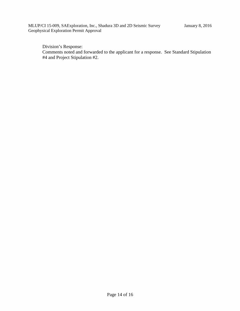
Project Description: Proposed Activity, Associated Structures, Type of Equipment: SAE proposes to conduct a three dimensional and two dimensional seismic acquisition program on the Kenai Peninsula in the northern portion of the Refuge during the winter of 2016. The expected program dates are from February 1, 2016, through April 15, 2016. The program will be conducted entirely onshore utilizing helicopters to deploy and retrieve equipment and personnel. The use of tracked vehicles, excluding snowmachines, is not anticipated. No overland travel of equipment is proposed. The project area includes approximately 85 square miles: approximately 82 square miles of refuge lands, approximately 2.5 square miles of state lands, and approximately 0.5 square miles of private lands.
SAE expects to acquire a broad band full azimuth seismic dataset capable of imaging structural and stratigraphic features at the required target depths. This will be achieved by conventional acquisition techniques. Survey data will be acquired by sequentially deploying seismic sources and crews via helicopter, detonating charges one at a time across the survey area, recording returned signals, and retrieving the autonomous receivers. Initially the logistical front-end operations, including scouting, permitting, and survey will be followed by seismic operations consisting of drilling, data acquisition and cleanup. The project will border the coast line on the western edge but will not extend past the bluff line, see Appendix C, (Figure 2: Surface Ownership). Project Area Legal Description: Meridian: Seward Township: 007N Range: 009W Sections: 3-10, 15-18 Range: 010W Sections: 1-5, 11-14 Township: 008N Range: 009W Sections: 1-11, 14-23, 26-35 Range: 010W Sections: 1-3, 10-14, 23-26, 32-36 Township: 009N Range: 008W Sections: 5-8, 17-20, 29-31 Range: 009W Sections: 1, 11-15, 21-36 Range: 010W Section: 36 Scope of Decision: This decision is reviewing the following activities for Division approval: The geophysical exploration activities on State of Alaska public domain lands as defined in the application. This decision is not reviewing the following activities for Division approval: Activities supporting seismic data acquisition on private lands, CCSRA, federal lands and state marine waters.
MLUP/CI 15-009, SAExploration, Inc., Shadura 3D and 2D Seismic Survey January 8, 2016 Geophysical Exploration Permit Approval
Page 3 of 16
Land Status: The proposed SAE Shadura 3D and 2D Seismic Survey program includes approximately 2.5 square miles of state land on the Kenai Peninsula Appendix C, (Figure 1: Project Area). Identified Interests within or near the Project Area: These interests are identified in Alaska’s Land Administration System and Alaska Mapper both available online at http://dnr.alaska.gov/mlw/index.htm. Legislatively Designated Areas: Captain Cook State Recreation Area, Kenai National Wildlife Refuge. Oil and Gas leases: ADL 391844 Apache Alaska Corporation, ADL 391596 Nordaq Energy Inc. Permits, Leases, Easements: ADL 69354 Tesoro Alaska Pipeline Co Pipeline Right of Way LAS 58826 Nordaq Energy Inc. MLUP LAS 29719 Nordaq Energy Inc. MLUP ADL 37591 Phillips Gas Supply Corp Easement ADL 2317 Homer Electric Association Inc. Easement ADL 231291 Homer Electric Association Inc. Easement Mental Health Trust Lands: S50290, S50293, S50297, S50298, SM-1262, SM-1296, SM-1083, SM-1090 Land Agreements, Settlements, Conveyances, Reconveyances and Municipal Entitlements of land: Numerous parcels exist within the project area which are not state public domain land. This permit does not grant access to any non-public domain state lands or to non-state lands. Agency Review: The Division provided an Agency review and comment opportunity for the activities considered for authorization under this decision. The following government entities were notified on December 9, 2015 for comment on the application: United States Coast Guard (USCG), United States Army Corps of Engineers (USACE) , Kenai Peninsula Borough (KPB), National Oceanic and Atmospheric Administration (NOAA), United States Fish and Wildlife Service (USFWS), United States National Park Service (USNPS), United States Environmental Protection Agency (USEPA), Cook Inlet Region, Incorporated (CIRI), City of Kenai, Alaska Department of Fish and Game (ADFG), Alaska Department of Environmental Conservation (ADEC), Alaska Oil and Gas Conservation Commission (AOGCC), Department of Transportation & Public Facilities (DOTPF), and DNR: Division of Mining Land and Water (DMLW), Office of Project Management and Permitting (OPMP), Office of History and Archaeology (OHA), Division of Parks & Outdoor Recreation (DPOR), and Division of Oil and Gas. The comment deadline was 4:30 pm Alaska time on December 23, 2015. Comments were received by KPB, ADEC, and DPOR. Agency comments and SAE’s responses are summarized in Appendix B.
MLUP/CI 15-009, SAExploration, Inc., Shadura 3D and 2D Seismic Survey January 8, 2016 Geophysical Exploration Permit Approval
Page 4 of 16
Public Review: The public notice process is discretionary and was not initiated for this application. Notification: In accordance with 11 AAC 96.030(c), the Division provided notification to upland landowners that the Division received a MLUP application to conduct geophysical activities on shorelands, tide lands, or submerged lands adjacent to their properties. Performance Guarantee: The permittee has provided the Division with a performance guarantee under 11 AAC 96.060 in the amount of $100,000. Insurance: The certificate of insurance has been furnished to the department and lists the State of Alaska, DNR as an additional named insured on the policy. The policy is issued by an insurer licensed to transact the business of insurance under AS 21. Application Approved: Should any unforeseen issues arise, the Division has the authority to amend or revoke this permit. As detailed in this permit, the Division shall be notified if, during the conduct of activities, a surface use conflict occurs. All activities conducted under this permit are subject to inspection by the Division, and if damage occurs, appropriate interest holders will be engaged and corrective action will be prescribed. The Division will impose additional provisions as necessary under 11 AAC 96.040 at any time during the activity approved under this permit to minimize impacts and conflicts. The Division considered all facts material to this application including the permit provisions contained in this authorization per 11 AAC 96.040(b). The Division has determined that this permit as conditioned by the attached provisions for this non-permanent activity is in the state’s interest. Stipulations in this permit authorization are necessary to protect the state’s interest and the public interest. An eligible person affected by this decision may appeal it, in accordance with 11 AAC 02. Any appeal must be received within 20 calendar days after the date of issuance of this decision, as defined in 11 AAC 02.040 (c) and (d), and may be mailed or delivered to the Commissioner, Department of Natural Resources, 550 W. 7th Avenue, Suite 1400, Anchorage, Alaska 99501; faxed to 1-907-269-8918; or sent by electronic mail to [email protected]. This decision takes effect immediately. An eligible person must first appeal this decision in accordance with 11 AAC 02 before appealing this decision to Superior Court. A copy of 11 AAC 02 may be obtained from any regional information office of the Department of Natural Resources.
MLUP/CI 15-009, SA Exploration, Inc. , Shadura 3D and 2D Seismic Survey Geophysical Exploration Permit Approval
Sincerely,
Kim Kruse Permitting Manager Division of Oil and Gas
Appendices: A: Stipulations B: Comments C: Maps
January 8, 2016
ecc: Division: Kim Kruse, Thomas Barrett, John Easton, Jeanne Frazier and Heather Heusser DMLW: Project Development Team, Clifford Larson, James Sowerwine, Eric Moore and Henry Brooks ADFG: Marla Carter and Virginia Litchfield ADEC: [email protected], Jamie Grant, Gary Evans, Mike Evans, Graham Wood and Tim Law OPMP: Sara Taylor, Mark Morones, Sara Longan and Jeff Bruno Borough: Marcus Mueller, Johni Blankenship, Julie Denison and Dan Nelson AOGCC: James Regg DOTPF: David Post DPOR: Pamela Russell , and Ryan Thomas Other: CIRI, Barbara Mahoney, Kimberly Klein, Lynnda Kahn, Linda Speerstra, Sandra Modigh, and Michael Dombkowski
Page 5 of 15
MLUP/CI 15-009, SAExploration, Inc., Shadura 3D and 2D Seismic Survey January 8, 2016 Geophysical Exploration Permit Approval
Page 6 of 16
APPENDIX A: STIPULATIONS MISCELLANEOUS LAND USE PERMIT FOR GEOPHYSICAL EXPLORATION
Geophysical and Seismic activities are subject to the following permit stipulations: Standard Stipulations:
1. The permittee shall defend, indemnify and hold the State of Alaska harmless from and against any and all claims, damages, suits, losses, liabilities and expenses for injury to or death of persons and damage to or loss of property arising out of or in connection with the entry on and use of State lands authorized under this permit by the permittee, its contractors, subcontractors and their employees.
2. A copy of the permit and stipulations must be posted in a prominent location where other permits
and safety information are displayed for crew members. The permittee shall make available a copy of the application, all subsequent modifications, and a copy of this permit and all its attachments to any interested party upon request in a reasonable time.
3. The permittee shall notify and obtain a modification from the Division in advance of any
activities which deviate from the approved permit. Any action taken by the permittee or his agent which increases the overall scope of the project or which negates, alters, or minimizes the implied intent of any stipulation contained in this permit will be considered a deviation from the approved permit.
4. The issuance of this permit does not alleviate the necessity of the permittee to obtain
authorization required by other agencies for this activity. 5. The permittee shall inform and ensure compliance with all conditions of this permit by its
employees, agents and contractors, including subcontractors at any level. 6. Reservation of Rights: The Division reserves the right to grant additional authorizations to third
parties for compatible uses on or adjacent to the land under this permit. Authorized concurrent users of state land, their agents, employees, contractors, subcontractors, and licensees, shall not interfere with the operation or maintenance activities of each user.
7. Valid Existing Rights: This permit is subject to all valid existing rights and to the land. The
State of Alaska makes no representations or warranties whatsoever, either expressed or implied, as to the existence, number, or nature of such valid existing rights.
8. The Commissioner of the DNR may require that an authorized state representative be present
during any oil and gas activities described in or conducted under this permit. 9. The permittee shall consult the Alaska Heritage Resources Survey (907-269-8721) so that known
historic, archeological and paleontological sites may be avoided. Should any sites be discovered during the course of field operations, activities that may damage the site will cease and the
MLUP/CI 15-009, SAExploration, Inc., Shadura 3D and 2D Seismic Survey January 8, 2016 Geophysical Exploration Permit Approval
Page 7 of 16
Office of History and Archaeology in the Division of Parks and Outdoor Recreation (907-269-8721) shall be notified immediately.
10. The permittee shall make available, to the Division, all records relating to the permit activities
and landowner approvals upon request. 11. The permittee shall observe and apply applicable setbacks as defined by 18 AAC 80.020,
18 AAC 72 and/or the International Association of Geophysical Contractors Setback Guidelines to activities approved under this authorization. Alternative setback distances may be employed to protect coastal uses and resources, water wells, structures, private property including livestock, and other resources if it is determined that a particular guideline is insufficient.
12. Trails, campsites and work areas must be kept clean. Trash, survey lath, markers, and other
debris that accumulates in camps, along seismic lines, and travel routes that are not recovered during the initial cleanup, shall be picked up and properly disposed of within one calendar year.
13. The Director has the right at any time to modify or revoke this permit. 14. All wastewater must be disposed of in a manner acceptable to ADEC and must meet Alaska
Water Quality Standards found at: http://dec.alaska.gov/water/wqsar/wqs/. 15. ADEC Drinking Water regulations 18 AAC 80 apply to public water systems.
16. Performance Guaranty. To ensure performance with all of the terms of the permit and to cover
the potential cost of restoring the site, the permittee will maintain security acceptable to the state.
17. Insurance. The permittee shall maintain insurance to protect the State from risks associated with the planned activities during the term of the permit. The Permittee shall maintain a comprehensive general liability insurance policy with the state named as an additional insured party. The insurance requirement must be for no less than $1,000,000.00 per occurrence and $2,000,000.00 per annual aggregate. The insurance requirement may be adjusted periodically by the Division.
Land and Access Stipulations: 1. The permit authorizes the Permittee to conduct geophysical/seismic exploration activity upon
lands owned by the State of Alaska. No person may engage in mineral exploratory activity on land, the surface of which has been granted or leased by the State of Alaska, or on land for which the state has received the reserved interest of the United States.
2. This permit does not authorize activity on Mental Health Trust Lands, School Trust Lands, Park Lands, or Lands of the University of Alaska.
3. Approval of this permit does not constitute the approval required for surface entry on non-state
land without an agreement with the surface owner. This permit does not approve entry on private land.
MLUP/CI 15-009, SAExploration, Inc., Shadura 3D and 2D Seismic Survey January 8, 2016 Geophysical Exploration Permit Approval
Page 8 of 16
4. The seismic exploration activities granted under this permit must not diminish the use and
enjoyment of lands encompassed within a Native Allotment. Before entering a pending or approved Native Allotment, the permittee shall contact the Bureau of Indian Affairs and Bureau of Land Management and comply with applicable federal law.
Public Safety and Program Outreach Stipulations: 1. Public safety: Appropriate signage will be deployed on all access routes and roadways in the
project area. The Department of Transportation or Right of Way Lessee may advise permittee on appropriate measures to maintain safe conditions where appropriate. The permittee must watch for, provide verbal warning to and document people or vehicles entering potentially dangerous areas of the project. Lighting and marking with lath or fluorescent tape of some project work areas is advised for activities that occur during periods of sustained darkness or where conditions are unsafe for humans or animals.
2. Notices: To avoid unintended conflicts with other users, the permittee shall post a Notice of this
project at conspicuous locations including key travel intersection crossings, areas of public use and in a prominent location in any operators or contractors staging area or camp. The Notice shall include the Division’s contact number (907-269-8800), project title and permit number, names and contact telephone numbers of the permittee and all operators. The permittee shall provide notices on behalf of the Division to all upland owners involving shoreland, tideland, or submerged land adjacent to the upland owner’s property if no notice or agreement is made with the owner by the permittee as required under 11 AAC 96.030(c). All forms of public outreach must be documented and reported to the Division as they occur.
3. In areas of subsistence and personal use harvesting, the permittee will coordinate survey activity
with local users to prevent unnecessary conflicts. The permittee shall make a good faith attempt to coordinate survey activities with the owners of trap lines if known. Existing snowmachine, dogsled, or other trails, should be marked with survey lath where they intersect receiver and source lines. The permittee is required to post notice of potentially dangerous or hazardous project activities at these locations.
Fuel and Hazardous Substances Stipulations: 1. Fuel and hazardous substances. Secondary containment shall be provided for fuel or hazardous
substances, as defined under AS 46.03.826 (5) or under 42 U.S.C. 9601(14)F. 2. Fuel or hazardous substance transfers. Secondary containment or a surface liner must be placed
under all container or vehicle fuel tank inlet and outlet points, hose connections, and hose ends during fuel or hazardous substance transfers. Appropriate spill response equipment to respond to a spill of up to five gallons must be on hand during any transfer or handling of fuel or hazardous substances. Transfer operations shall be attended by trained personnel at all times.
3. Fuel or hazardous substances container(s) with a total combined capacity larger than 55 gallons
shall not be stored within 100 feet of a waterbody.

MLUP/CI 15-009, SAExploration, Inc., Shadura 3D and 2D Seismic Survey January 8, 2016 Geophysical Exploration Permit Approval
Page 9 of 16
4. Sorbent material in sufficient quantity to handle operation spills must be on hand at all times for use in the event of an oil or fuel spill.
5. Any use of explosives or blasting materials must comply with ADFG Habitat Publication No.
13-03, Alaska Blasting Standard for the Proper Protection of Fish. Additionally the permittee must contact the nearest ADFG Division of Habitat office regarding the need for a Fish Habitat permit.
6. Stationary fuel storage facilities must not be placed within the annual floodplain of a watercourse
or closer than 100 feet to a waterbody. There shall be no fueling, servicing or repair of vehicles or equipment, and no vehicles shall be left unattended within the floodplain or below the ordinary high water line of any river, lake or stream or closer than 100 ft. to a waterbody or wetland.
Wildlife Stipulations: 1. All activities shall be conducted in a manner to minimize or avoid disturbance to wildlife and
their habitat. Hazing of wildlife is prohibited unless a Health Safety and Environment concern is present.
2. Activities must avoid occupied grizzly bear dens and black bear dens, by one-half mile unless
alternative mitigation measures to minimize disturbance are authorized by the Division after consultation with ADFG. Known den locations shall be obtained from the nearest ADFG Division of Wildlife Conservation office prior to starting operations. Occupied dens encountered in the field must be reported to the above, and subsequently avoided.
3. The permittee shall abide by the provisions of Alaska’s wildlife feeding regulation, 5 AAC 92.230. 4. Activities within State-designated special areas (AS 16.20.010- .162, .500-.690) will be
conducted in a manner consistent with the area’s statutes regulations and management plan. Cook Inlet Stipulations: 1. If flowing or artesian water is encountered during the drilling of shot holes, the DMLW shall be
contacted at 907-269-8645. Action may be required to stop the flow. 2. On-site refuse disposal is prohibited. The permittee will remove and dispose of all waste
generated during operation and termination activities under this authorization to an off-site ADEC approved disposal facility. Waste, in this stipulation, means all discarded matter, including but not limited to human waste, trash, garbage, refuse, oil drums, petroleum products, ash and discarded equipment. Unattended vehicles and equipment will not be parked or left on the traveled surface of existing off- line trails or access routes.
Project Specific Stipulations: 1. The permittee shall obtain a separate authorization from KPB.
MLUP/CI 15-009, SAExploration, Inc., Shadura 3D and 2D Seismic Survey January 8, 2016 Geophysical Exploration Permit Approval
Page 10 of 16
2. The permittee is required to obtain a permit from DPOR to access CCSRA.
3. The certificate of insurance provided to the Division lists a 1 million dollar aggregate in commercial general liability. The Insurance Policy provided to the Division demonstrates how the certificate of insurance meets the 2 million dollar aggregate insurance requirement for this permit through the Aggregate Drop-Down Endorsement. Specifically, page 53, explains how funds are available beyond the 1 million dollar aggregate listed on the certificate of insurance. The Insurance Policy being finalized for 2016 must be submitted to the Division to demonstrate the insurance minimums are maintained.
Reporting Stipulations: 1. Geophysical Data Submission Requirement Form: As a stipulation of the issuance of this
MLUP for Geophysical Exploration, the permittee acknowledges the requirements of 11 AAC 96.210 (1) and agrees to notify the Director of the Division of the availability of processed seismic exploration data within 30 days of completion of initial processing and submit seismic exploration data. The Geophysical Data Submission Requirements can be found on the DNR Division’s Website http://dog.dnr.alaska.gov/Permitting/permittingForms.htm. Your signature acknowledges your obligation to fulfill the Data Submittal requirements. This report shall be submitted to [email protected] before each survey commences.
2. Activity Completion Report Upon expiration of the MLUP or completion of all activities authorized under the MLUP, whichever occurs first, an Activity Completion Report must be submitted summarizing activities, equipment trails, camps and staging areas, damages to State lands and surface impacts, lost equipment, fires, and unintended explosions, spills, land-use conflicts and work completed. The report shall include a map depicting all mulched trails. Rehabilitation, if required, shall be completed to the satisfaction of the DNR. This report shall be submitted to [email protected]. If the term of the MLUP exceeds one calendar year from the date of approval, an annual Activity Completion Report, in addition to the final Activity Completion Report, must be submitted discussing the above information and projected activities for the rest of the permit term. If no activities are completed under the MLUP, an Activity Completion Report must be submitted on or before the expiration of the MLUP stating that no activities occurred.
3. Geophysical Activity Completion Report Form: The permittee must complete and return a
Geophysical Activity Completion Report form for each survey acquired. Please submit a separate form for each sub-program data submittal. A non-confidential public completion report will be placed into the MLUP permit file each time a sub-program is completed. Geophysical Activity Completion reports must be submitted to the Division’s Resource Evaluation Section within 30 days of completion of all activities. For in depth instructions on how to complete the form, please refer to the Division’s permitting website http://dog.dnr.alaska.gov/Permitting/PermittingForms.htm. This report shall be submitted to [email protected]. If no activities are completed under the MLUP, an Activity Completion Report from must be submitted on or before the expiration of the MLUP; be sure to check box 27 to indicate the survey was cancelled.
MLUP/CI 15-009, SAExploration, Inc., Shadura 3D and 2D Seismic Survey January 8, 2016 Geophysical Exploration Permit Approval
Page 11 of 16
4. Geophysical Processing Completion Report Form: The permittee must complete and return a
Geophysical Activity Completion Report form for each survey acquired. Please submit a separate form for each sub-program data submittal. A confidential Processing Completion report will be submitted each time a sub-program is completed. The Processing Completion reports must be submitted to the Division’s Resource Evaluation Section within 30 days of completion of initial processing. For in depth instructions on how to complete the form please refer to the Division’s permitting website http://dog.dnr.alaska.gov/Permitting/PermittingForms.htm. This report shall be submitted to [email protected]
5. In-Field Operations Notice: During activities conducted under the MLUP, the permittee must
submit weekly reports summarizing activities undertaken and their location within the permit area. These reports shall be submitted to [email protected].
6. Spill Notifications: The permittee shall comply with the ADEC requirements for reporting the unauthorized discharge, leak, or spill of hydrocarbons or toxic or hazardous substances. The permittee shall notify the Department of Natural Resources of all spills that must be reported under 18 AAC 75.300 under timelines of 18 AAC 75.300. All unintentional fires and explosions must be reported to DNR immediately. The DNR 24 hour spill number is (907) 451-2678; the fax number is (907) 451-2751. DNR and ADEC shall be supplied with all follow-up incident reports.
7. Blowouts, as defined as the detonation of source points that caused surface damaged, are reportable if the surface damaged is larger than 36 inches. The report must include the location (Lat./Long. in WGS 84) and pictures of the blowout. All blowouts will need to be reclaimed or rehabilitated to the satisfaction of the Alaska DNR.
8. A summary record of all surface impacts, lost equipment, spills, fires, and unintended explosions, shall be included in the Permitting Section’s completion report. Rehabilitation, if required, shall be completed to the satisfaction of the DNR.
9. All fires and explosions that require a response to protect life and property must be reported to
DNR and ADEC immediately and shall be supplied with all follow-up incident reports. 10. The Division’s Permitting Section shall be notified in Anchorage by telephone at 907-269-8800
and by email at [email protected] if, during the conduct of activities, state resources are damaged or a conflict occurs.
11. The permittee shall make available a copy of the seismic application, all subsequent
modifications, and a copy of this permit and all its attachments to any interested party upon request in a reasonable time.
I acknowledge, and agree to these Permit terms, conditions and stipulations.
MLUP/CI 15-009, SAExploration, Inc., Shadura 3D and 2D Seismic Survey January 8, 2016 Geophysical Exploration Permit Approval
Page 13 of 16
Appendix B: Comments Agency Review Comments:
1. Ms. Julie Denison with KPB, December 10, 2015: Ms. Denison stated “any activities that affect land owned or managed by the KPB requires separate authorization from the KPB.” Applicant’s Response: SAE spoke briefly with Ms. Denison on the project and SAE is aware that a permit from the borough is necessary. SAE will submit a permit request to the KPB. Division’s Response: Comment noted and forwarded to the applicant for a response. See Standard Stipulation #4 and Project Stipulation #1.
2. Mr. Jamie Grant with ADEC, December 15, 2015: Mr. Grant stated “thank you for the opportunity to comment on MLUP Application (MLUP/CI 15-009) submitted by SAE for the Shadura 3D and 2D Project on the Kenai Peninsula. The ADEC, Wastewater Discharge Authorization Program (WDAP), Oil and Gas Section has no comments or objections at this time.” Division’s Response: Comment noted and forwarded to the applicant for their information.
3. Ms. Pamela Russell with DPOR, December 17, 2015: Ms. Russell stated “I am submitting DNR, DPOR comments for the SAE Shadura 3D and 2D seismic work.
• The Project Area depicted in SAE’s MLUP application includes lands within CCSRA, specifically S008N010W, Section 3 and portions of Section 10. AS 41.21.410 provides for the governor to establish the CCSRA which Governor Egan did by proclamation in November, 1981.
• CCSRA has been closed to multiple purpose use under A.S. 41.21.410 as a special purpose site in accordance with article VIII, sec. 7 of Alaska Constitution.
• The management of CCSRA is governed by Title 41, Chapter 21 and the administrative regulations found in 11 AAC Chapters 12, 18 and 20.
• Provisions of Title 38 and the regulations found within 11 AAC Chapter 96 do not apply to CCSRA, and thus state land within the boundaries of CCSRA should not be included in a MLUP issued to SAE for geophysical exploration.”
Applicant’s Response: “SAE is already submitted an application with the division of state parks. The permit Process for access through the CCSRA will be worked with this division.” SAE also stated it has been in contact with Pam and have discussed the state statute listed in the comments.
MLUP/CI 15-009, SAExploration, Inc., Shadura 3D and 2D Seismic Survey January 8, 2016 Geophysical Exploration Permit Approval
Page 14 of 16
Division’s Response: Comments noted and forwarded to the applicant for a response. See Standard Stipulation #4 and Project Stipulation #2.
MLUP/CI 15-009, SAExploration, Inc., Shadura 3D and 2D Seismic Survey January 8, 2016 Geophysical Exploration Permit Approval
Page 15 of 16
Appendix C: Maps
Figure 1: Project Area

MLUP/CI 15-009, SAExploration, Inc., Shadura 3D and 2D Seismic Survey January 8, 2016 Geophysical Exploration Permit Approval
Page 16 of 16
Figure 2: Surface Ownership


![[XLS]doa.alaska.govdoa.alaska.gov/ogc/DigLog/CookInlet/CIindex.xls · Web viewILD SN SP DT GR MLS MLD CALI MGS ST 17595 20 SFL ILM ILD GR DRHO SP DT CNS CALI RHOB MGS ST 17595 23](https://img.pdfslide.net/doc/110x75/5b00bdd17f8b9a952f8d5544/xlsdoa-viewild-sn-sp-dt-gr-mls-mld-cali-mgs-st-17595-20-sfl-ilm-ild-gr-drho-sp.jpg)