Embed Size (px)
Citation preview
Department of Natural Resources
DIVISION OF OIL AND GAS
550 W. 7th Avenue Suite 1100 Anchorage, Alaska 99501-3560
Main: 907.269.8800 Fax: 907.269.8939
February 15, 2018 Ms. Sue Simonds Permits and Regulatory Manager SAExploration, Inc 8240 Sandlewood Place Anchorage, AK 99507 RE: MLUPNS 18-001, SAExploration, Inc., Yukon 3D Geophysical Exploration Permit Approval Dear Ms. Simonds,
The Department of Natural Resources (DNR), Division of Oil and Gas (Division) approves the SAExploration, Inc. (SAE) Yukon 3D Miscellaneous Land Use Permit (MLUP) application, dated January 13, 2018, to conduct geophysical exploration on State of Alaska lands on the North Slope. The enclosed permit, MLUPNS 18-001, authorizes SAE to conduct a land and marine based seismic survey on State of Alaska land and waters within the Eastern Coastal Area of the North Slope subject to the conditions of the permit. This project includes approximately 251 square miles of three-dimensional (3D) acquisition. This permit is effective February 15, 2018, to May 31, 2018. Issuance of a permit under 11 AAC 96 is not a disposal of an interest in land and does not grant a preference right to a lease or other disposal. The permit is revocable for cause for violation of a permit stipulation of this chapter, and is revocable at will if DNR determines that the revocation is in the State's interest. The proposed activities are for a discrete and limited duration with limited, temporary impact to the land, and are not part of a larger project or investment by the permittee that might weigh against revoking the permit. Therefore, the permit is both legally and functionally revocable. Each permit issued is subject to any stipulations DNR determines necessary to ensure compliance with this chapter, minimize environmental impacts and conflicts with other uses, or otherwise be in the interests of the State. Public notice of any miscellaneous land use application is discretionary under 11 AAC 96.030(c). The Director of the Division (Director) has the right at any time to amend or modify any provisions of this permit, or revoke this permit. Project Description: Proposed Activity, Associated Structures, Type of Equipment: SAE plans to conduct a 3D survey approximately 40 miles east of Deadhorse, Alaska. The project area covers approximately 251 square miles and will occur during the 2018 winter season (Appendix C). The proposed program will be acquired on State lands and waters in the North Slope Borough (NSB). SAE will stage equipment from existing facilities in Deadhorse. The camp and
SAE MLUPNS 18-001 Yukon 3D February 15, 2018 Geophysical Exploration Permit Approval
Page 2 of 13
equipment will be trucked via road infrastructure to a point of access to the tundra or sea ice. The crew will mobilize to existing gravel pads near the project area, which will allow access to the tundra and provide a resupply area for the crews. Winter-approved vehicles will be used to transport the sled camp along the tundra. The camp will remain close to the survey activities and will move every two to five days depending on the survey progress and snow cover. After the survey is completed, the camp and equipment will travel along the tundra or sea ice to a gravel pad for offloading and then return to SAE’s Deadhorse pad location. Ice checking will continue until the close of tundra travel. The data acquisition will be conducted utilizing up to 12 rubber tracked or buggy vibrators per crew that operate in groups or independently. Generally, receiver lines run perpendicular to source lines and will be spaced a minimum of 660 feet apart. Receivers are typically located every 110 to 200 feet along this line and will be laid out by crews on foot and by use of rubber tracked vehicles and snowmachines. There could be 16 to 24 receiver lines placed on the ground at a time with vibrators typically operating on two lines at a time. The energy source is a Vibroseis with a frequency of approximately four to 100 Hz with the anticipation of four to eight seconds for each sweep, although this is subject to change. Source lines will be spaced approximately 550 to 660 feet apart. Cleanup operations will be conducted the summer after the seismic program to inspect for any remaining debris not identified and removed during demobilization activities, and to identify any remnant issues. All debris collected will be disposed at an approved waste facility in Deadhorse. Project Area Legal Description
Meridian: Umiat Township: 7N Range: 21E Sections: 1, 2 Range: 22E Sections: 1-6 Range: 23E Sections: 1-6 Range: 24E Sections: 6 Township: 8N Range: 21E Sections: 1, 2, 11-14, 23-25, 35, 36 Range: 22E Sections: 1-36 Range: 23E Sections: 1-36 Range: 24E Sections: 3-10, 16-20, 29-31 Township: 9N Range: 21E Sections: 1-4, 9-16, 21-28, 33-36 Range: 22E Sections: 1-36 Range: 23E Sections: 1-36 Range: 24E Sections: 3-10, 15-21, 28-32 Township: 10N Range: 21E Sections: 25-28, 33-36 Range: 22E Sections: 25-36 Range: 23E Sections: 28-36 Range: 24E Sections: 31, 32
SAE MLUPNS 18-001 Yukon 3D February 15, 2018 Geophysical Exploration Permit Approval
Page 3 of 13
Scope of Decision: This decision is reviewing the following activities for Division approval: Activities supporting seismic data acquisition on State of Alaska land and waters have been reviewed under the authority of this approval. This decision is not reviewing the following activities for Division approval: State land within the Umiat Meridian in the North Slope area has been designated as Special Use Lands under ADL 50666. A permit is required from the Division of Mining, Land and Water (DMLW) for motorized use, unless it is for subsistence purposes or on a graveled road. Tundra travel is approved by DMLW. Land Status: The proposed Yukon 3D program is located on State land and waters on the North Slope. The SAE project area covers approximate 251 square miles. Other third party interests identified: ADL 414827 – Municipal Entitlement ADL 414854 – Municipal Entitlement ADL 418975 – Point Thomson Export Pipeline Right of Way ADL 419827 – Material Sale Site ADL 420600 – Potential Hazardous Sites ADL 420601 – Potential Hazardous Sites Land Agreements, Settlements, Conveyances, Reconveyances and Municipal Entitlements of land: Numerous parcels exist within the project area that are not public land. This permit does not grant access to any non-State lands. Agency Review: The Division provided an agency review and comment opportunity for the activities considered for authorization under this decision. The following government entities were notified on January 25, 2018, for comment on the Plan: NSB, Alaska Department of Fish and Game (ADF&G), Alaska Department of Environmental Conservation (ADEC), and the DNR Divisions of Mining, Land and Water, and Oil and Gas. The comment deadline was 4:30 pm Alaska time on February 8, 2018. Comments were submitted by ADF&G and DMLW. The Division and Agency comments are summarized in Appendix B. Public Review: The public notice process is discretionary and was not initiated for this application. Performance Guarantee: The permittee has provided the Division with a performance guarantee under 11 AAC 96.060 in the amount of $100,000.
SAE MLUPNS 18-001 Yukon 3D February 15, 2018 Geophysical Exploration Permit Approval
Page 4 of 13
Insurance: The certificate of insurance has been furnished to the DNR and lists the State of Alaska, Department of Natural Resources as an additional named insured on the policy. The policy is issued by an insurer licensed to transact the business of insurance under AS 21. Application Approved: Should any unforeseen issues arise, the Division has the authority to amend or revoke this permit. As detailed in this authorization, the Division shall be notified if, during the conduct of activities, a surface use conflict occurs. All activities conducted under this permit are subject to inspection by the Division, and if damage occurs, appropriate interest holders will be engaged and corrective action will be prescribed. The Division will impose additional provisions as necessary under 11 AAC 96.040 at any time during the activity approved under this permit to minimize impacts and conflicts. The Division considered all facts material to this application, including the permit provisions contained in this authorization per 11 AAC 96.040(b). The Division has determined that this permit, as conditioned by the attached provisions for this non-permanent activity, is in the State’s interest. Stipulations in this permit authorization are necessary to protect State and public interests. An eligible person affected by this decision may appeal it, in accordance with 11 AAC 02. Any appeal must be received within 20 calendar days after the date of issuance of this decision, as defined in 11 AAC 02.040 (c) and (d), and may be mailed or delivered to the Commissioner, Department of Natural Resources, 550 W. 7th Avenue, Suite 1400, Anchorage, Alaska 99501; faxed to 1-907-269-8918; or emailed to [email protected]. This decision takes effect immediately. An eligible person must first appeal this decision in accordance with 11 AAC 02 before appealing this decision to Superior Court. A copy of 11 AAC 02 may be obtained from any regional information office of the Department of Natural Resources. Sincerely, Graham Smith Permitting Manager Division of Oil and Gas Appendices: A: Stipulations B: Comments C: Maps (Figure 1-3)
SAE MLUPNS 18-001 Yukon 3D February 15, 2018 Geophysical Exploration Permit Approval
Page 5 of 13
ecc: DOG: Graham Smith, Nathaniel Emery, Paul Blanche, Conor Williamson, Jeanne Frazier, SPCO Records, and Heather Heusser
DMLW: Melissa Head, Matthew Willison, Kimberley Maher, Becky Baird, and Henry Brooks ADF&G: Jack Winters ADEC: Oil and Gas, DEC and Laurie Silfven Borough: Jason Bergerson, Josie Kaleak, Matt Dunn
SAE MLUPNS 18-001 Yukon 3D February 15, 2018 Geophysical Exploration Permit Approval
Page 6 of 13
APPENDIX A: STIPULATIONS MISCELLANEOUS LAND USE PERMIT FOR GEOPHYSICAL EXPLORATION
Geophysical and Seismic activities are subject to the following permit stipulations: Standard Stipulations:
1. The permittee shall defend, indemnify and hold the State of Alaska harmless from and against any and all claims, damages, suits, losses, liabilities and expenses for injury to or death of persons and damage to or loss of property arising out of or in connection with the entry on and use of State lands authorized under this permit by the permittee, its contractors, subcontractors and their employees.
2. A copy of the permit and stipulations must be posted in a prominent location where other permits
and safety information are displayed for crew members. The permittee shall make available a copy of the application, all subsequent modifications, and a copy of this permit and all its attachments to any interested party upon request in a reasonable time.
3. The permittee shall notify and obtain a modification from the Division in advance of any
activities that deviate from the approved permit. Any action taken by the permittee or his agent which increases the overall scope of the project or which negates, alters, or minimizes the implied intent of any stipulation contained in this permit will be considered a deviation from the approved permit.
4. The issuance of this permit does not alleviate the necessity of the permittee to obtain
authorization required by other agencies for this activity. 5. The permittee shall inform and ensure compliance with all conditions of this permit by its
employees, agents and contractors, including subcontractors at any level. 6. Reservation of Rights: The Division reserves the right to grant additional authorizations to third
parties for compatible uses on or adjacent to the land under this permit. Authorized concurrent users of State land, their agents, employees, contractors, subcontractors, and licensees, shall not interfere with the operation or maintenance activities of each user.
7. Valid Existing Rights: This permit is subject to all valid existing rights and to the land. The State
of Alaska makes no representations or warranties whatsoever, either expressed or implied, as to the existence, number, or nature of such valid existing rights.
8. The DNR Commissioner may require that an authorized State representative be present during
any oil and gas activities described in or conducted under this permit. 9. The permittee shall consult the Alaska Heritage Resources Survey (907-269-8721) so that known
historic, archeological and paleontological sites may be avoided. Should any sites be discovered during the course of field operations, activities that may damage the site will cease and the
SAE MLUPNS 18-001 Yukon 3D February 15, 2018 Geophysical Exploration Permit Approval
Page 7 of 13
Office of History and Archaeology in the Division of Parks and Outdoor Recreation (907-269-8721) shall be notified immediately.
10. The permittee shall make available to the Division all records relating to the permit activities and
landowner approvals upon request. 11. The permittee shall observe and apply applicable setbacks as defined by 18 AAC 80.020,
18 AAC 72 and/or the International Association of Geophysical Contractors Setback Guidelines to activities approved under this authorization. Alternative setback distances may be employed to protect coastal uses and resources, water wells, structures, private property including livestock, and other resources if it is determined that a particular guideline is insufficient.
12. Trails, campsites and work areas must be kept clean. Trash, survey lath, markers, and other
debris that accumulates in camps, along seismic lines, and travel routes that are not recovered during the initial cleanup, shall be picked up and properly disposed of within one calendar year.
13. The Director has the right at any time to modify or revoke this permit. 14. All wastewater must be disposed of in a manner acceptable to ADEC and must meet Alaska
Water Quality Standards found at: http://dec.alaska.gov/water/wqsar/wqs/. 15. ADEC Drinking Water regulations 18 AAC 80 apply to public water systems.
16. Performance Guaranty. To ensure performance with all of the terms of the permit and to cover
the potential cost of restoring the site, the permittee will maintain security acceptable to the state.
17. Insurance. The permittee shall maintain insurance to protect the State from risks associated with the planned activities during the term of the permit. The Permittee shall maintain a comprehensive general liability insurance policy with the State named as an additional insured party. The insurance requirement must be for no less than $1,000,000.00 per occurrence and $2,000,000.00 per annual aggregate. The insurance requirement may be adjusted periodically by the Division.
Land and Access Stipulations: 1. The permit authorizes the Permittee to conduct geophysical/seismic exploration activity upon
lands owned by the State of Alaska. No person may engage in mineral exploratory activity on land, the surface of which has been granted or leased by the State of Alaska, or on land for which the State has received the reserved interest of the United States.
2. This permit does not authorize activity on Mental Health Trust Lands, School Trust Lands, Park Lands, or Lands of the University of Alaska.
3. Approval of this permit does not constitute the approval required for surface entry on non-State
land without an agreement with the surface owner. This permit does not approve entry on private land.
SAE MLUPNS 18-001 Yukon 3D February 15, 2018 Geophysical Exploration Permit Approval
Page 8 of 13
4. The seismic exploration activities granted under this permit must not diminish the use and
enjoyment of lands encompassed within a Native Allotment. Before entering a pending or approved Native Allotment, the permittee shall contact the Bureau of Indian Affairs and Bureau of Land Management and comply with applicable federal law.
Public Safety and Program Outreach Stipulations: 1. Public safety: Appropriate signage will be deployed on all access routes and roadways in the
project area. The Department of Transportation or Right of Way Lessee may advise permittee on appropriate measures to maintain safe conditions where appropriate. The permittee must watch for, provide verbal warning to and document people or vehicles entering potentially dangerous areas of the project. Lighting and marking with lath or fluorescent tape of some project work areas is advised for activities that occur during periods of sustained darkness or where conditions are unsafe for humans or animals.
2. Notices: To avoid unintended conflicts with other users, the permittee shall post a Notice of this
project at conspicuous locations including key travel intersection crossings, areas of public use and in a prominent location in any operators or contractors staging area or camp. The Notice shall include the Division’s contact number (907-269-8800), project title and permit number, names and contact telephone numbers of the permittee and all operators. The permittee shall provide notices on behalf of the Division to all upland owners involving shoreland, tideland, or submerged land adjacent to the upland owner’s property if no notice or agreement is made with the owner by the permittee as required under 11 AAC 96.030(c). All forms of public outreach must be documented and reported to the Division as they occur.
3. In areas of subsistence and personal use harvesting, the permittee will coordinate survey activity
with local users to prevent unnecessary conflicts. The permittee shall make a good faith attempt to coordinate survey activities with the owners of trap lines if known. Existing snowmachine, dogsled, or other trails, should be marked with survey lath where they intersect receiver and source lines. The permittee is required to post notice of potentially dangerous or hazardous project activities at these locations.
Fuel and Hazardous Substances Stipulations: 1. Fuel and hazardous substances. Secondary containment shall be provided for fuel or hazardous
substances, as defined under AS 46.03.826 (5) or under 42 U.S.C. 9601(14)F. 2. Fuel or hazardous substance transfers. Secondary containment or a surface liner must be placed
under all container or vehicle fuel tank inlet and outlet points, hose connections, and hose ends during fuel or hazardous substance transfers. Appropriate spill response equipment to respond to a spill of up to five gallons must be on hand during any transfer or handling of fuel or hazardous substances. Transfer operations shall be attended by trained personnel at all times.
3. Fuel or hazardous substances container(s) with a total combined capacity larger than 55 gallons
shall not be stored within 100 feet of a waterbody.
SAE MLUPNS 18-001 Yukon 3D February 15, 2018 Geophysical Exploration Permit Approval
Page 9 of 13
4. Sorbent material in sufficient quantity to handle operation spills must be on hand at all times for use in the event of an oil or fuel spill.
5. Any use of explosives or blasting materials must comply with ADF&G Habitat Publication No.
13-03, Alaska Blasting Standard for the Proper Protection of Fish. Additionally the permittee must contact the nearest ADF&G Division of Habitat office regarding the need for a Fish Habitat permit.
6. Stationary fuel storage facilities must not be placed within the annual floodplain of a watercourse
or closer than 100 feet to a waterbody. There shall be no fueling, servicing or repair of vehicles or equipment, and no vehicles shall be left unattended within the floodplain or below the ordinary high water line of any river, lake or stream or closer than 100 feet to a waterbody or wetland.
Wildlife Stipulations: 1. All activities shall be conducted in a manner to minimize or avoid disturbance to wildlife and
their habitat. Hazing of wildlife is prohibited unless a Health Safety and Environment concern is present.
2. Activities must avoid occupied grizzly bear dens and black bear dens, by one-half mile unless
alternative mitigation measures to minimize disturbance are authorized by the Division after consultation with ADF&G. Known den locations shall be obtained from the nearest ADF&G Division of Wildlife Conservation office prior to starting operations. Occupied dens encountered in the field must be reported to the above, and subsequently avoided.
3. The permittee shall abide by the provisions of Alaska’s wildlife feeding regulation, 5 AAC 92.230. 4. Activities within State-designated special areas (AS 16.20.010- .162, .500-.690) will be
conducted in a manner consistent with the area’s statutes regulations and management plan. 5. All marine activities will be conducted in accordance with any voluntary action submitted by the
permittee and approved by the National Marine Fisheries Service (NMFS). The Incidental Harassment Authorization (IHA) application describes specific operational procedures, mitigation measures, observer protocols, and other measures designed to protect marine mammals from potential impacts of marine seismic activities. All activities authorized under this permit are required to meet other State and federal requirements, such as the Marine Mammal Protection Act (MMPA), Endangered Species Act (ESA), and other applicable laws protecting marine mammals.
6. Activities must avoid known polar bear dens by one mile. Known den locations shall be
obtained from the U.S. Geological Survey (907-786-3800 or 800-362-5148) prior to starting operations. New dens encountered in the field must be reported to the above, and subsequently avoided by one mile.
SAE MLUPNS 18-001 Yukon 3D February 15, 2018 Geophysical Exploration Permit Approval
Page 10 of 13
North Slope Stipulations: 1. Crossing of water bodies and activities near fish bearing water bodies may require permits from
ADF&G; the permittee is required to obtain all permits necessary for this project prior to commencing activities authorized by this permit.
2. All solid wastes, including incinerator residue, shall be backhauled to a solid waste disposal site
approved by ADEC. 3. The use of ground contact vehicles for off-road travel must be limited to those areas which have
adequate ground frost and snow cover to prevent damage to the ground surface as determined by DMLW Northern Region Office (NRO). Movement of equipment through willow (Salix) stands must be avoided wherever possible. The use of ground contact vehicles for off-road travel is subject to regional tundra travel openings and closure notices issued by DMLW NRO.
4. Vehicles shall be operated in a manner such that the vegetative mat is not disturbed, and blading or removal of vegetative cover is prohibited except as approved by DMLW NRO. Filling of low spots and smoothing using snow and ice is allowed. Incidents of vegetative mat damage and follow-up corrective actions shall be reported to the Division.
5. The DNR DMLW maintains tundra monitoring stations throughout the North Slope. Tundra
monitoring stations must not be impacted by permitted activities. Specific location information for these sites can be obtained from the DNR DMLW directly at 907-451-2740.
Reporting Stipulations: 1. Geophysical Data Submission Requirement Form: As a stipulation of the issuance of this
MLUP for Geophysical Exploration, the permittee acknowledges the requirements of 11 AAC 96.210 (1) and agrees to notify the Director of the Division of the availability of processed seismic exploration data within 30 days of completion of initial processing and submit seismic exploration data. The Geophysical Data Submission Requirements can be found on the DNR Division’s Website https://dog.dnr.alaska.gov/Services/Applications. Your signature acknowledges your obligation to fulfill the Data Submittal requirements. This report shall be submitted to [email protected] before each survey commences.
2. Activity Completion Report: Upon expiration of the MLUP or completion of all activities authorized under the MLUP, whichever occurs first, an Activity Completion Report must be submitted summarizing activities, equipment trails, camps and staging areas, damages to State lands and surface impacts, lost equipment, fires, and unintended explosions, spills, land-use conflicts and work completed. The report shall include a map depicting all mulched trails. Rehabilitation, if required, shall be completed to the satisfaction of the DNR. This report shall be submitted to [email protected]. If the term of the MLUP exceeds one calendar year from the date of approval, an annual Activity Completion Report, in addition to the final Activity Completion Report, must be submitted discussing the above information and projected activities for the rest of the permit term. If no
SAE MLUPNS 18-001 Yukon 3D February 15, 2018 Geophysical Exploration Permit Approval
Page 11 of 13
activities are completed under the MLUP, an Activity Completion Report must be submitted on or before the expiration of the MLUP stating that no activities occurred.
3. Geophysical Activity Completion Report Form: The permittee must complete and return a
Geophysical Activity Completion Report form for each survey acquired. Please submit a separate form for each sub-program data submittal. A non-confidential public completion report will be placed into the MLUP permit file each time a sub-program is completed. Geophysical Activity Completion reports must be submitted to the Division’s Resource Evaluation Section within 30 days of completion of all activities. For in-depth instructions on how to complete the form, please refer to the Division’s permitting website https://dog.dnr.alaska.gov/Services/Applications. This report shall be submitted to [email protected]. If no activities are completed under the MLUP, an Activity Completion Report from must be submitted on or before the expiration of the MLUP; be sure to check box 27 to indicate the survey was cancelled.
4. Geophysical Processing Completion Report Form: The permittee must complete and return a Geophysical Activity Completion Report form for each survey acquired. Please submit a separate form for each sub-program data submittal. A confidential Processing Completion report will be submitted each time a sub-program is completed. The Processing Completion reports must be submitted to the Division’s Resource Evaluation Section within 30 days of completion of initial processing. For in depth instructions on how to complete the form please refer to the Division’s permitting website https://dog.dnr.alaska.gov/Services/Applications. This report shall be submitted to [email protected]
5. In-Field Operations Notice: During activities conducted under the MLUP, the permittee must
submit weekly reports summarizing activities undertaken and their location within the permit area. These reports shall be submitted to [email protected].
6. Spill Notifications: The permittee shall comply with the ADEC requirements for reporting the unauthorized discharge, leak, or spill of hydrocarbons or toxic or hazardous substances. The permittee shall notify the Department of Natural Resources of all spills that must be reported under 18 AAC 75.300 under timelines of 18 AAC 75.300. All unintentional fires and explosions must be reported to DNR immediately. The DNR 24 hour spill number is (907) 451-2678; the fax number is (907) 451-2751, DOG must be notified at [email protected]. DNR and ADEC shall be supplied with all follow-up incident reports.
7. Blowouts, as defined as the detonation of source points that caused surface damaged, are reportable if the surface damaged is larger than 36 inches. The report must include the location (Lat./Long. in WGS 84) and pictures of the blowout. All blowouts will need to be reclaimed or rehabilitated to the satisfaction of the Alaska DNR.
8. A summary record of all surface impacts, lost equipment, spills, fires, and unintended explosions, shall be included in the Permitting Section’s completion report. Rehabilitation, if required, shall be completed to the satisfaction of the DNR.
SAE MLUPNS 18-001 Yukon 3D February 15, 2018 Geophysical Exploration Permit Approval
Page 13 of 13
APPENDIX B: Agency Review Comments
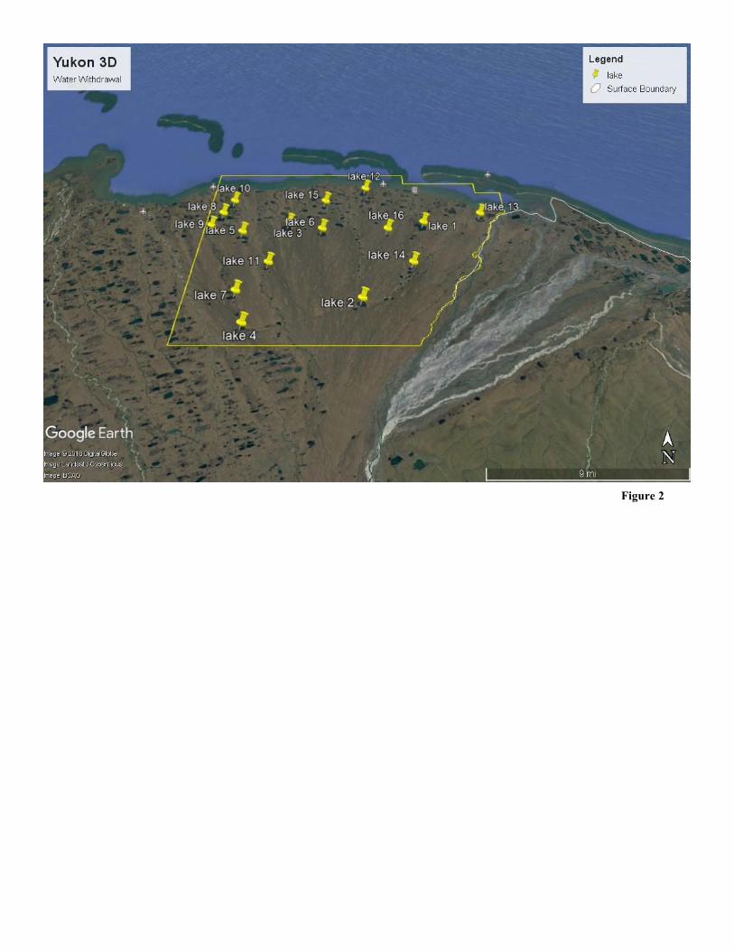
Alaska Department of Fish and Game, February 1, 2018 The ADF&G has reviewed the 3D geophysical exploration application submitted by SAExploration for its proposed Yukon 3D program from Bullen Point to the Staines River. The ADF&G has no objection to the proposed project and has issued a fish habitat permit to SAExploration for travel across anadromous fish streams and for water withdrawal from lakes in the program area.
Division Response: Comments noted.
Alaska Department of Mining, Land, and Water, February 9, 2018
In reference to MLUPNS 18-001, SAExploration Yukon 3D application, the DMLW submits the following comments: SAExploration will need an off-road travel approval to access the acquisition area. SAE has not yet applied to the DMLW for this access. The current route provided in the maps attached are near or coincident with an approved snow trail that is used on an as-needed basis by ExxonMobil Alaska Production (EMAP). If the same snow trail is used, SAE will need to demonstrate that they are working with EMAP to use the route. The DMLW would prefer that established routes are used to access the acquisition area. This could be either the EMAP snow trail or the ice road to the Badami Unit operated by Savant Alaska, LLC.
Division Response: Comments noted and forwarded to SAE.
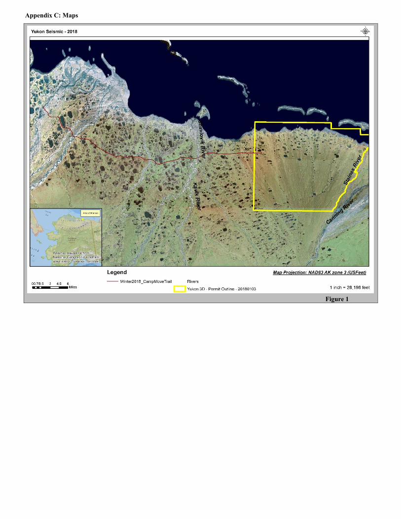
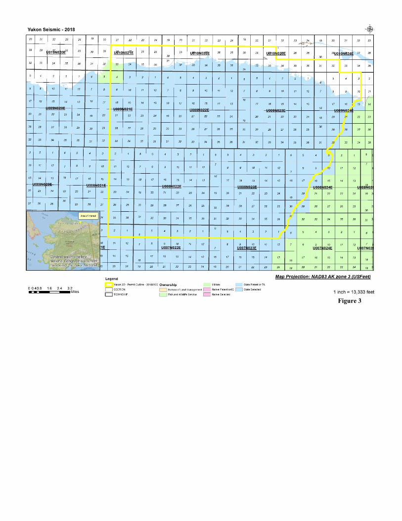
Appendix C: Maps
i e
i e
i e