Embed Size (px)
Citation preview
Department of the Army NEW ORLEANS DISTRICT, CORPS OF ENGINEERS
P.O. BOX 60267 NEW ORLEANS, LOUISIANA 70160-0267
June 7, 2012
1-1
RECORD OF DECISION AND PERMIT EVALUATION
Application Number: MVN-2005-00037 Applicant: Louisiana Department of Transportation and Development Project Name: Highway 3241, between Interstate 12 and LA Highway 21 in Bush, Louisiana, in
St. Tammany Parish
1. INTRODUCTION
The Louisiana Department of Transportation and Development (LADOTD) submitted an application for a Department of the Army (DA) permit on October 23, 2006 for their preferred alternative. The application (MVN-2005-00037) requested a DA permit to construct a new four-lane highway from the LA 40/41 intersection in Bush, Louisiana, to Interstate 12 (I-12). The preferred alternative would be a new 17.4 mile highway segment beginning at the intersection of LA HWY 21and LA HWY 41 following the abandoned railroad line to a point north of Talisheek, Louisiana before heading southwesterly to connect to I-12 at the LA Hwy 1088 interchange with I-12. Three other alternatives were determined to be practicable.
All proposed alternatives are located in St. Tammany Parish, Louisiana, within an area roughly bounded by LA 21, U.S. Highway (US) 190, I-12, US 11, and LA 41. It encompasses approximately 245 square miles in area and includes the incorporated areas of Abita Springs, Pearl River, and portions of the cities of Slidell and Covington. Unincorporated areas such as Bush, Hickory, Talisheek, and Waldheim are included in the project area.
Depending upon the alignment authorized, the proposed project would directly impact between 305 and 385 acres of jurisdictional wetlands. Wetlands impacted by the proposed project constitute a productive and valuable public resource. These wetlands perform important functions and have values of social significance, providing surface water storage (flood control), stream-flow maintenance (maintaining aquatic habitat and aesthetic appreciation opportunities), groundwater recharge (some types replenish water supplies), sediment removal and nutrient cycling (water quality protection), aquatic productivity (fishing and waterfowl hunting), production of trees (timber harvest), production of herbaceous growth (livestock grazing and haying), and plant and wildlife habitat (hunting, trapping, plant/wildlife/nature photography, nature observation, and aesthetics).
The U.S. Army Corps of Engineers (USACE), New Orleans District (CEMVN) prepared an environmental assessment (August 28, 2008) for the proposed project which concluded that implementation of the proposed project would result in significant environmental impacts and as required by the National Environmental Policy Act (NEPA) of 1969, an Environmental Impact Statement (EIS) must be prepared. The Draft EIS (DEIS) that evaluated the potential environmental impacts from construction of the proposed highway was released on September 9, 2011. The Final EIS (FEIS) was released on March 9, 2012.
1.1 Record of Decision
This document constitutes a Record of Decision for a DA permit application under Section 404 of the Clean Water Act (CWA) (33 United States Code 1344) and for the FEIS for a proposal by the LADOTD to construct a highway to connect I-12 to Bush, Louisiana in St. Tammany Parish. This document addresses the requirements contained in Section 404 of the CWA and NEPA in accordance with Title 40 Part 1505.2 – NEPA and Agency Decisionmaking and with the procedures described at 33 Code of Federal Regulations (CFR) Part 320-332, including Appendices B and C. This Record of Decision (ROD)
1-2
incorporates by reference USACE’s I-12 to Bush, DEIS, September 2011 and the I-12 to Bush, FEIS, March 2012 which includes the Section 404(b)(1) Evaluation (Appendix K).
1.2 Permit Decision.
A Section 401 Water Quality Certification (WQC) (33USC § 1342) has not been issued for the proposed project and must be obtained from the Louisiana Department of Environmental Quality (LDEQ). I have determined that a WQC should be obtained before a DA permit can be issued. I have also determined that an approved mitigation plan must be developed prior to issuance of a permit. Should the applicant obtain the necessary WQC and develop a mitigation plan acceptable to the resource agencies and approved by CEMVN, it would be my decision based on all available information, including the Final EIS, that issuance of a permit under authority of Section 404 of the CWA for Alternative Q, identified by the Section 404(b)(1) Analysis (Appendix K to the FEIS) as the Least Environmentally Damaging Practicable Alternative (LEDPA), is in compliance with Section 404(b)(1) Guidelines and is not contrary to the public interest. The authorization would contain special conditions and mitigation requirements to avoid, minimize and mitigate project-related impacts to ensure compliance with the findings of my decision as presented in this ROD.
2-1
2. PROJECT INFORMATION
2.1 Proposed Action
LADOTD proposes to construct a four-lane arterial highway from the southern terminus of the current four-lane arterial portion of LA 21 in Bush, Louisiana, to I-12. A typical cross section would have two 12-foot travel lanes, an 8- to 10-foot outside shoulder, and a 4-foot inside shoulder in each direction. The median width would vary, depending on highway design class used, ranging between 40 and 60 feet, and a maximum right-of-way (ROW) requirement of 250 feet. The exception to that design could be as the proposed project transitions into existing roadways (i.e. intersections), and where alternative alignments follow the existing LA 21.
To ensure an adequate foundation, existing soils could be excavated and hauled-in earthen fill obtained from an undetermined source could be deposited to elevate the highway embankment over natural grades. Borrow and useable material for the project would be obtained from LADOTD-approved upland areas outside the project area (the area bounded by LA 21 to west, LA 41 to east, and I-12 to south). Roadway embankments would be sloped with inside slopes of approximately 6:1 for 26 feet from edge of shoulder and then 4:1 thereafter. Roadside ditches would be constructed as required to reduce ponding along the roadway. A typical design of the ditch would be 4 feet below existing grade with a width of 4 feet. Ditches would only be employed to divert surface water flow to structural highway crossings as required in non-wetland areas. Drainage structures would be identified so as to have no net impact on the drainage and sheetflow in the vicinity of the proposed project. Drainage structures could include bridges, reinforced boxes, or reinforced pipes depending on the flow to be passed through the structure.
2.2 Jurisdiction
The project proposes to work in wetlands and structural crossings of various waterways in the project area therefore a DA permit pursuant to section 404 of the CWA is required before any construction activities. Because the proposed project requires federal involvement, it is subject to NEPA. The EIS was undertaken in accordance with the NEPA, Council on Environmental Quality (CEQ) regulations, and USACE regulations for implementing NEPA. This EIS has been prepared to address NEPA, environmental and cultural resource laws, USACE Regulatory Program Regulations (Title 33 of the Code of Federal Regulations [CFR] Parts 320–332), including the USACE NEPA regulations at 33 CFR Part 325, Appendix B, and the requirements of the section 404(b)(1) guidelines (40 CFR Part 230), so that the EIS provides the information needed for the USACE permit decision-making process.
2.3 Project Purpose/Need
Under NEPA guidelines and implementing regulations in 40 CFR 1502.13 and 33 CFR 320.4, the lead federal agency must state the purpose and need for the proposed action when preparing an EIS. Defining the project purpose is critical to the evaluation of any project’s compliance with the section 404(b)(1) guidelines. In accordance with section 404(b)(1) Guidelines for Specification of Disposal Sites for Dredged or Fill Material, Subpart B, Compliance with the Guidelines, [40 CFR 230.10(a)(3)], where the activity associated with a discharge which is proposed for a special aquatic site (as defined in subpart E) does not require access or proximity to or siting within the special aquatic site in question to fulfill its basic purpose (i.e., is not ``water dependent''), practicable alternatives that do not involve special aquatic sites are presumed to be available, unless clearly demonstrated otherwise. In addition, where a discharge is proposed for a special aquatic site, all practicable alternatives to the proposed discharge, which do not involve a discharge into a special aquatic site are presumed to have less adverse impacts on the aquatic ecosystem, unless clearly demonstrated otherwise. CWA guidelines (40 CFR 230) distinguish between the basic purpose and overall project purpose, and specify that the basic purpose determines whether the proposed action is water dependent. This distinction ensures that the scope of the EIS and the range of alternatives analyzed are sufficiently broad to fully inform the agency decision maker.
2-2
The EIS has been prepared based on CEMVN’s defined purpose and need, but also considered the proposed transportation network improvement anticipated benefits compared to the expected detriments. LADOTD has stated that the proposed highway would provide an alternative north-south connection that could reduce congestion and delays for those traveling from northern St. Tammany Parish and Washington Parish to I-12. The proposed highway could increase safety by reducing the amount of traffic and congestion on existing routes (LA 41 and LA 21/LA 59/US 190), and thereby reduce the potential for accidents. In addition, travel time savings could help support and enhance potential economic development in northern St. Tammany and Washington Parishes. In addition, LADOTD is obliged to construct the proposed highway to comply with Louisiana Revised Statute 47:820.2B(e), which requires “[t]he Louisiana Highway 3241 project from Interstate 12 to Bush…shall be constructed as a [four]-lane or more highway.”
2.3.1 Basic Project Purpose & Water Dependency Determination
The basic project purpose is to provide for regional transportation needs. As such, the proposed project does not require siting within a special aquatic site to fulfill its basic purpose.
2.3.2 Overall Project Purpose
The overall project purpose is to construct a four-lane arterial highway from the southern terminus of LA 21 in Bush, Louisiana, to I-12.
2.4 Rationale for Determining Practicability of Alternatives
The USACE regulatory permit review process requires an analysis of alternative highway alignments and alternative project designs to demonstrate the avoidance and minimization of impacts on the aquatic resources to the greatest extent possible. NEPA requires that a No Build Alternative be analyzed to determine the environmental consequences of not undertaking the proposed project, and thereby providing a framework for measuring the benefits and adverse effects of other alternatives. Pursuant to CWA section 404(b), the USACE defines practicable alternatives as those that are, “available and capable of being done after taking into consideration cost, existing technology, and logistics in light of overall project purposes.” On the basis of the information, screening analysis, and preliminary evaluation, the following alternatives were selected by the USACE for a more detailed impacts analysis: No Build, Alternative B/O, Alternative J, Alternative P, and Alternative Q.
2.5 Alternatives Considered but Not Included in Detailed Analysis
Of the original 64 proposed alternatives, all but 13 were eliminated for final screening for analysis. The remaining 13 alternatives were further screened to determine which would be carried forward for detailed analysis. The FEIS discusses reasons for eliminating alternatives and why the four build alternatives were carried over to be fully evaluated in the EIS.
2.6 Alternatives Considered
In accordance with 33 CFR 325.9(5), the USACE is neither an opponent nor proponent of the applicant’s proposal. The USACE has three action alternatives relative to the LEDPA. The three alternative actions available to the USACE are: 1) issue the permit; 2) issue the permit with special conditions; or 3) deny the permit. An analysis of alternative site plans for avoiding and minimizing project specific impacts to waters of the U.S. including wetlands is discussed in Section 4.4 of the EIS. Alternatives are evaluated and discussed in Section 4.0 in the EIS. Permit denial is identified and described in the EIS as the No Build Alternative in Section 4.0. In accordance with 33 CFR Part 320.4(b)(4) and 40 CFR 230.10, the USACE performed an evaluation of alternatives, as described below.
2-3
2.6.1 No Build Alternative
Under the No Build Alternative, the USACE would not issue any permits for construction of a new four-lane highway between Bush and I-12. As a result, the existing roadway network in the region would remain in its current condition and continue to serve as the transportation network to travel between Bush and I-12. LADOTD could implement future roadway projects in the project area that could improve the transportation network, but those projects might not necessarily fully meet the purpose and need of this project. The No Build Alternative ensures that there would be no direct or indirect impacts to threatened and endangered (T&E) species, wetlands, environmentally sensitive areas, aquatic resources, or historic sites. Including the CEQ-required No Build Alternative in the EIS serves as a benchmark against which build alternatives can be evaluated. If the proposed highway is not constructed, project-related impacts would be avoided. Other alternatives would have to be developed to provide anticipated project benefits.
2.6.2 Alternative B/O
Alternative B/O would widen LA 21 to a four-lane highway from Bush to just north of Waldheim, then continue as a new four-lane roadway about halfway between Alternatives B and O before capturing Alternative O just north of LA 435, terminating at LA 1088 near I-12. This alternative would use as much of existing highway alignments and non-wetland areas as possible to minimize impacts to the human and natural environment. The alternative would be approximately 19.5 miles long, with 7.0 miles on existing alignment and 12.5 miles on new alignment. The majority of the alignment would consist of an rural arterial (RA)-3 typical cross section, which would have a typical ROW width requirement of 250 feet. Control of access could be provided except where the highway follows existing LA 21 and highway crossings at LA 435 and LA 36, and the connection to LA 1088.
2.6.3 Alternative J
Alternative J would be new construction of a four-lane highway following the abandoned railroad corridor from Bush to a point due north of the Slidell Municipal Airport. From that point, the proposed route would connect to Airport Road, which ties into I-12 at an existing interchange (Exit 80). This proposed route would be approximately 21.1 miles long, with 14.2 miles using the abandoned railroad embankment, 5.4 miles on new alignment, and 1.5 miles of existing roadway. The majority of the route (17.5 miles) would consist of an RA-3 typical cross section, which would have a typical ROW width of 250 feet. The northern 0.7 mile of the route would consist of an RA-2 cross section, while the southern 1.9 miles would have suburban arterial (SA)-1 cross section. Control of access to the route could be provided for the section of highway classified as RA-3 (17.5 miles), except for the segment through Talisheek (2.0 miles) and where the highway crosses LA 435 and LA 36.
2.6.4 Alternative P
LADOTD’s preferred alignment, Alternative P, would begin at the intersection of LA 41 and LA 40 in Bush and proceed southward for approximately 17.4 miles to LA 1088. The majority of the project (15.2 miles) would consist of an RA-3 typical cross section, which has a typical ROW width requirement of 250 feet. The northern 0.7 mile of the project would consist of an RA-2 cross section, which also has a ROW width of 250 feet. The exception to that design would be at the southern end of the project area. The last 1.5 miles would be designed as an SA-1 typical section, which has a ROW width of approximately 180 feet. The proposed route would use an abandoned railroad corridor from Bush to Talisheek, a distance of approximately 2.5 miles, before turning southwesterly for approximately 13.3 miles on a new alignment to connect with LA 1088 north of I-12. Access for this route would be provided in Bush, at LA 435, at LA 36, and at the intersection with LA 1088. Crossings of existing highways would be at grade.
2-4
2.6.5 Alternative Q
Alternative Q would include new construction of a four-lane highway following the abandoned railroad corridor from Bush to a point approximately 1.7 miles north of LA 36. From that point, the proposed route would leave the railroad corridor and connect to LA 434, which ties into I-12 at an existing interchange (Exit 74). This alternative would be approximately 19.8 miles long, with 9.8 miles using the abandoned railroad embankment, 8.7 miles on new alignment, and 1.3 miles on existing roadway. The majority of the alternative (17.2 miles) would consist of an RA-3 typical cross section, which would have a typical ROW width of 250 feet. The northern 0.7 miles of the route would have an RA-2 cross section, with a ROW width of 250 feet. Control of access to the route could be provided for the section of highway classified as RA-3 (17.3 miles), except for the segment through Talisheek (2.0 miles) and where the highway crosses LA 435, LA 36, and connects to LA 434.
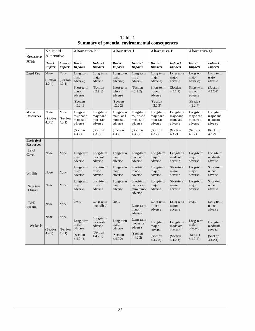
2.7 Environmental consequences by alternative
Direct, indirect, and cumulative environmental, cultural, and socioeconomic effects were analyzed that would likely occur upon implementation of the four alternatives, plus the no build alternative. The physical, natural, social impacts for each alternative are discussed in Section 4.0 of the FEIS. The impacts to each resource area are outlined in the following table. Cumulative effects were analyzed taking into account past, present, and reasonably foreseeable future actions in the project area and are discussed in Section 4.18 of the FEIS and below in Section 4.24 of this ROD.
2-5
Table 1 Summary of potential environmental consequences
Resource Area
No Build Alternative
Alternative B/O Alternative J Alternative P Alternative Q
Direct Impacts
Indirect Impacts
Direct Impacts
Indirect Impacts
Direct Impacts
Indirect Impacts
Direct Impacts
Indirect Impacts
Direct Impacts
Indirect Impacts
Land Use
None
(Section 4.2.1)
None
(Section 4.2.1)
Long-term major adverse;
Short-term minor adverse
(Section 4.2.2.1)
Long-term major adverse
(Section 4.2.2.1)
Long-term major adverse;
Short-term minor adverse
(Section 4.2.2.2)
Long-term major adverse
(Section 4.2.2.2)
Long-term major adverse;
Short-term minor adverse
(Section 4.2.2.3)
Long-term major adverse
(Section 4.2.2.3)
Long-term major adverse;
Short-term minor adverse
(Section 4.2.2.4)
Long-term major adverse
(Section 4.2.2.4)
Water Resources
None
(Section 4.3.1)
None
(Section 4.3.1)
Long-term major and moderate adverse
(Section 4.3.2)
Long-term major and moderate adverse
(Section 4.3.2)
Long-term major and moderate adverse
(Section 4.3.2)
Long-term major and moderate adverse
(Section 4.3.2)
Long-term major and moderate adverse
(Section 4.3.2)
Long-term major and moderate adverse
(Section 4.3.2)
Long-term major and moderate adverse
(Section 4.3.2)
Long-term major and moderate adverse
(Section 4.3.2)
Ecological Resources
Land Cover
Wildlife
Sensitive Habitats
T&E Species
Wetlands
None
None
None
None
None
(Section 4.4.1)
None
None
None
None
None
(Section 4.4.1)
Long-term major adverse
Long-term major adverse
Long-term major adverse
None
Long-term major adverse
(Section 4.4.2.1)
Long-term moderate adverse
Short-term minor adverse
Short-term minor adverse
Long-term negligible
Long-term moderate adverse
(Section 4.4.2.1)
Long-term major adverse
Long-term major adverse
Long-term major adverse
None
Long-term major adverse
(Section 4.4.2.2)
Long-term moderate adverse
Short-term minor adverse
Short-term and long-term minor adverse
Long-term minor adverse
Long-term moderate adverse
(Section 4.4.2.2)
Long-term major adverse
Long-term major adverse
Long-term major adverse
Long-term minor adverse
Long-term major adverse
(Section 4.4.2.3)
Long-term moderate adverse
Short-term minor adverse
Short-term minor adverse
Long-term minor adverse
Long-term moderate adverse
(Section 4.4.2.3)
Long-term major adverse
Long-term major adverse
Long-term major adverse
None
Long-term major adverse
(Section 4.4.2.4)
Long-term moderate adverse
Short-term minor adverse
Short-term minor adverse
Long-term minor adverse
Long-term moderate adverse
(Section 4.4.2.4)
2-6
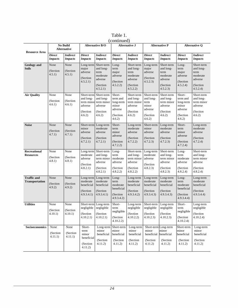
Table 1. (continued)
Resource Area
No Build Alternative
Alternative B/O Alternative J Alternative P Alternative Q
Direct Impacts
Indirect Impacts
Direct Impacts
Indirect Impacts
Direct Impacts
Indirect Impacts
Direct Impacts
Indirect Impacts
Direct Impacts
Indirect Impacts
Geology and Soils
None
(Section 4.5.1)
None
(Section 4.5.1)
Long-term major adverse
(Section 4.5.2.1)
Short-term and long-term moderate adverse
(Section 4.5.2.1)
Long-term major adverse
(Section 4.5.2.2)
Short-term and long-term moderate adverse
(Section 4.5.2.2)
Long-term major adverse
(Section 4.5.2.3)
Short-term and long-term moderate adverse
(Section 4.5.2.3)
Long-term major adverse
(Section 4.5.2.4)
Short-term and long-term moderate adverse
(Section 4.5.2.4)
Air Quality None
(Section 4.6.1)
None
(Section 4.6.1)
Short-term and long-term minoradverse
(Section 4.6.2)
Short-term and long-term minor adverse
(Section 4.6.2)
Short-term and long-term minor adverse
(Section 4.6.2)
Short-term and long-term minor adverse
(Section 4.6.2)
Short-term and long-term minor adverse
(Section 4.6.2)
Short-term and long-term minor adverse
(Section 4.6.2)
Short-term and long-term minor adverse
(Section 4.6.2)
Short-term and long-term minor adverse
(Section 4.6.2)
Noise None
(Section 4.7.1)
None
(Section 4.7.1)
Short-term minor adverse
(Section 4.7.2.1)
Long-term moderate adverse
(Section 4.7.2.1)
Short-term minor adverse
(Section 4.7.2.2)
Long-term moderate adverse
(Section 4.7.2.2)
Short-term minor adverse
(Section 4.7.2.3)
Long-term moderate adverse
(Section 4.7.2.3)
Short-term minor adverse
(Section 4.7.2.4)
Long-term moderate adverse
(Section 4.7.2.4)
Recreational Resources
None
(Section 4.8.1)
None
(Section 4.8.1)
Long-term moderate adverse
(Section 4.8.2.1)
Short-term and long-term minor adverse
(Section 4.8.2.1)
Long-term moderate adverse
(Section 4.8.2.2)
Short-term and long-term minor adverse
(Section 4.8.2.2)
Long-term moderate adverse
(Section 4.8.2.3)
Short-term and long-term minor adverse
(Section 4.8.2.3)
Long-term moderate adverse
(Section 4.8.2.4)
Short-term and long-term minor adverse
(Section 4.8.2.4)
Traffic and Transportation
None
(Section 4.9.2)
None
(Section 4.9.2)
Long-term moderate beneficial
(Section 4.9.3.4.1)
Long-term moderate beneficial
(Section 4.9.3.4.1)
Long-term moderate beneficial
(Section 4.9.3.4.2)
Long-term moderate beneficial
(Section 4.9.3.4.2)
Long-term moderate beneficial
(Section 4.9.3.4.3)
Long-term moderate beneficial
(Section 4.9.3.4.3)
Long-term moderate beneficial
(Section 4.9.3.4.4)
Long-term moderate beneficial
(Section 4.9.3.4.4)
Utilities None
(Section 4.10.1)
None
(Section 4.10.1)
Short-term negligible
(Section 4.10.2.1)
Long-term negligible
(Section 4.10.2.1)
Short-term negligible
(Section 4.10.2.2)
Long-term negligible
(Section 4.10.2.2)
Short-term negligible
(Section 4.10.2.3)
Long-term negligible
(Section 4.10.2.3)
Short-term negligible
(Section 4.10.2.4)
Long-term negligible
(Section 4.10.2.4)
Socioeconomics None
(Section 4.11.1)
None
(Section 4.11.1)
Short-term minor beneficial
(Section 4.11.2)
Long-term minor beneficial
(Section 4.11.2)
Short-term minor beneficial
(Section 4.11.2)
Long-term minor beneficial
(Section 4.11.2)
Short-term minor beneficial
(Section 4.11.2)
Long-term minor beneficial
(Section 4.11.2)
Short-term minor beneficial
(Section 4.11.2)
Long-term minor beneficial
(Section 4.11.2)
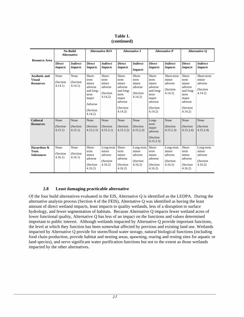
2-7
Table 1. (continued)
2.8 Least damaging practicable alternative
Of the four build alternatives evaluated in the EIS, Alternative Q is identified as the LEDPA. During the alternative analysis process (Section 4 of the FEIS), Alternative Q was identified as having the least amount of direct wetland impacts, least impacts to quality wetlands, less of a disruption to surface hydrology, and fewer segmentation of habitats. Because Alternative Q impacts fewer wetland acres of lower functional quality, Alternative Q has less of an impact on the functions and values determined important to public interest. Although wetlands impacted by Alternative Q provide important functions, the level at which they function has been somewhat affected by previous and existing land use. Wetlands impacted by Alternative Q provide for storm/flood water storage, natural biological functions (including food chain production, provide habitat and nesting areas, spawning, rearing and resting sites for aquatic or land species), and serve significant water purification functions but not to the extent as those wetlands impacted by the other alternatives.
Resource Area
No Build Alternative
Alternative B/O
Alternative J
Alternative P
Alternative Q
Direct Impacts
Indirect Impacts
Direct Impacts
Indirect Impacts
Direct Impacts
Indirect
Impacts
Direct Impacts
Indirect Impacts
Direct Impacts
Indirect Impacts
Aesthetic and Visual Resources
None
(Section 4.14.1)
None
(Section 4.14.1)
Short-term minor adverse and long-term major
Adverse
(Section 4.14.2)
Short-term minor adverse
(Section 4.14.2)
Short-term minor adverse and long-term major adverse
(Section 4.14.2)
Short-term minor adverse
(Section 4.14.2)
Short-term minor adverse and long-term major adverse
(Section 4.14.2)
Short-term minor adverse
(Section 4.14.2)
Short-term minor adverse and long-term major adverse
(Section 4.14.2)
Short-term minor adverse
(Section 4.14.2)
Cultural Resources
None
(Section 4.15.1)
None
(Section 4.15.1)
None
(Section 4.15.2.1)
None
(Section 4.15.2.1)
None
(Section 4.15.2.2)
None
(Section 4.15.2.2)
Long-term major adverse
(Section 4.15.2.3)
None
(Section 4.15.2.3)
None
(Section 4.15.2.4)
None
(Section 4.15.2.4)
Hazardous & Toxic Substances
None
(Section 4.16.1)
None
(Section 4.16.1)
Short-term minor adverse
(Section 4.16.2)
Long-term minor adverse
(Section 4.16.2)
Short-term minor adverse
(Section 4.16.2)
Long-term minor adverse
(Section 4.16.2)
Short-term minor adverse
(Section 4.16.2)
Long-term minor adverse
(Section 4.16.2)
Short-term minor adverse
(Section 4.16.2)
Long-term minor adverse
(Section 4.16.2)
3-1
3. PUBLIC INVOLVEMENT
3.1 DA Permit Application Public Notice
A public notice describing the application’s preferred alignment was advertized by CEMVN on November 10, 2006. Comments received were both pro and con. Of particular importance were comments received from the US Fish and Wildlife Service (USFWS) and the Environmental Protection Agency (EPA). Both agencies objected to permit issuance stating that the project as proposed in the public notice did not comply with the CWA Section 404(b)(1) Guidelines. Given the potential adverse direct, indirect, and cumulative impacts to wetlands and other aquatic resources in the Lake Pontchartrain Basin (including the lake itself), USFWS and EPA stated that the preferred route would have a substantial and unacceptable impact on aquatic resources of national importance pursuant to Part IV. 3(b) of the 1992 Memorandum of Agreement between EPA and the Department of the Army regarding CWA Section 404(q). Moreover, due to the potential significance of these impacts, both agencies stated that an EIS should be prepared.
An Environmental Assessment (EA) was prepared in August 2008 addressing potential impacts of the LADOTD’s preferred alignment and the other alternatives considered. Because of the significant adverse impacts associated with the LADOTD’s preferred alignment and potential significant adverse impacts associated with the other practicable alternatives, the EA recommended that an EIS be prepared for the proposed project.
3.2 Scoping
In September 2008, the EIS process was initiated. The public scoping meeting, the first step in the process, was held at the Abita Springs Town Hall on January 22, 2009. All interested agencies, tribes, non-governmental organizations, and individuals were invited to attend to provide input into the scoping process, after which a 30-day scoping period was open for public comment submission. The prepared Scoping Report summarizes the comments provided by the public and agencies. The most numerous comments were in regards to potential Environmental Consequences followed in descending order by Alternatives; Affected Environment; Consultation, Coordination, and Compliance; and Purpose and Need.
As a result of the scoping process, issues relevant to the EIS were verified and defined. Relevant issues raised during scoping are addressed under the following resource areas in the EIS:
Land Use. Land use refers to human use of the land for economic production (residential, commercial, industrial, recreational, or other purposes) and for natural resource protection. Land cover, an increasingly important attribute of land use, describes what is physically on the ground. The proposed highway will place demands on the region’s resources. The EIS analyzes the impacts that the proposed highway could have on existing and future land uses. The EIS reflects consideration of existing and proposed development, population growth, recreation resources, zoning regulations and other issues related to how the land surrounding the proposed highway would be used.
Noise. The EIS includes an analysis of any noise-related effects resulting from the use of heavy equipment during construction of the proposed highway and any other noise-generating activities associated with the highway after construction was complete (i.e., increase in traffic).
Water Resources and Water Quality. Water resources include various bodies of water residing or flowing in basins, channels, and other various natural and artificial landforms on the earth’s surface. Potential pollutant loads to be analyzed include stormwater runoff into the surrounding watershed. Water quality issues analyzed include dissolved oxygen, nutrients, heavy metals, and other pollutants. In addition, altered surface drainage patterns, changes in the subsurface water table and impacts on wetlands and other waterbodies were analyzed.
3-2
Ecological Communities. NEPA requires that analyses conducted for an EIS consider ecological information. Direct and indirect impacts that result in the loss of native vegetation, populations or species of fish and wildlife, sensitive species, wetland areas, and sensitive habitats must be considered for any action involving disturbance in naturally vegetated areas. The EIS evaluated any impacts on state or federally listed threatened or endangered species and nonnative plant and animal management.
Infrastructure Systems, Utilities, and Traffic and Transportation Systems. Analysis of infrastructure, utilities, and transportation systems related to the proposed highway includes sanitary sewer, stormwater collection and stormwater discharge, electricity, natural gas, telecommunication systems, regional road networks, traffic and congestion, safety, and road improvement and maintenance.
Socioeconomic Resources. Socioeconomics comprises the social, economic, and demographic characteristics of a region. The socioeconomic analysis includes an evaluation of labor force capacity, availability of housing, public services, educational facilities and educational fiscal revenues. The EIS provides historical data (including population, employment, personal income, and regional Gross Domestic Product [GDP]) to describe the regional growth of the area in the vicinity of the proposed highway. The historical data provide a frame of reference for determining the significance of any impacts on the socioeconomic environment expected as a result of the proposed highway. An economic model was used to generate a forecast that simulates the expected long-term growth of the project area on the basis of past and current trends and conditions. Environmental justice and protection of children are addressed, in accordance with EOs 12898 and 13045.
In addition to the resource areas on which the public commented during the scoping process, the following resource areas or issues were addressed in the EIS:
Soils and Geology. The EIS contains analyses of the environmental aspects of stratigraphy, topography, soils, and sediments; engineering properties of the materials; seismic hazards; slope stability; earthworks; mineral resources; unique landforms; and geological conditions that could limit the construction of the proposed highway, influence contaminant distribution and migration, or influence groundwater resources.
Hazardous and Toxic Materials. This resource area contains analyses of hazardous material management and hazardous waste management.
Cultural Resources. The EIS identifies properties in the project boundary that are on, or eligible for, the National Register of Historic Places or that qualify as Native American traditional cultural properties. The analyses consider impacts on any identified properties that could result from the construction and operation of the proposed highway.
Air Quality. The EIS contains an analysis of the potential impacts the proposed highway could have on air quality in the project area. The EIS has analyses of any impacts on air quality associated with road construction, operation and maintenance activities.
3.3 DEIS
The USACE made the DEIS available for public review and comment, published a notice of availability of the DEIS in the Federal Register, and sent copies of the DEIS to individuals who requested copies and to state and federal cooperating agencies. In addition, the USACE provided copies of the DEIS to local and statewide libraries. Agencies, organizations, and individuals were invited to review and comment on the document. The DEIS was available for a period of 45 days, beginning September 9, 2011 through October 24, 2011, to comment on the proposed action, the alternatives, and the adequacy of the analysis.
3-3
3.4 Public Hearing
During the 45-day comment period, a public hearing to receive comments on the DEIS specific to the proposed action was held on September 28, 2011 at the Abita Springs Town Hall. The hearing was held as a formal hearing following USACE guidelines with a short presentation on the project followed by formal public testimony. Approximately 175 citizens, 5 state and local elected officials, 23 agency representatives and 9 project team members attended the public hearing held at Abita Springs Town Hall, 22161 Level Street, Abita Springs, LA.
The objective of the public hearing was to seek input from individuals and community organizations on issues and concerns related to the DEIS and potential impacts associated with the proposed highway.
3.5 Substantive Issues, Applicant Reply and USACE Resolution
A total of 149 comments were received regarding the I-12 to Bush project during the 45-day public comment period. At the hearing, 14 written comment forms were submitted, 9 oral comments were recorded by the court reporter prior to the hearing, and 32 oral comments were taken during the hearing. During the comment period, 45 emails and 49 letters were submitted by the public.
A summary of the comments received during the public hearing include:
A few comments mentioned the presence of Gopher Tortoises in the project area.
Many comments expressed the need to preserve the quality of life and the natural environment.
The majority of comments concerned property loss and a few comments asked for an additional alternatives study or tweaking of alternatives to bypass more properties. Each build alternative would have impacts to private property.
Many comments supported the project touting the economic growth that better access to I-12 would bring to St. Tammany Parish and adjoining Washington Parish, as well as better access to medical facilities.
Some comments discussed the environmental impacts to wildlife and wetlands along the proposed highway corridor and the flooding impacts along properties. Detailed comments were submitted by the Nature Conservancy regarding the wetland mitigation banks in the area.
Louisiana Medical Center and Heart Hospital provided comments regarding noise and access impacts to medical facilities (Alt Q).
The St. Tammany Parish Department of Engineering provided detailed comments regarding impacts of each alternative, including the impacts Alt J would have on the National Weather Service Office.
A few comments indicated a concern for safety regarding the proximity of the proposed highway to property, while others indicated that the proposed highway would reduce the number of accidents and increase safety overall.
A few comments expressed concern regarding an increase in fire response times to neighborhoods due to impacts to access caused by the proposed highway. St. Tammany Fire Protection District #3 provided detailed impacts analysis of each alternative.
A few of the property owners expressed concern for air and noise pollution.
One commenter questioned impacts to access of recreational and social facilities, such as sports fields, library, and a senior citizen center. A few other comments discussed the impact to bicyclists, joggers, and walkers specifically regarding Alt B/O.
3-4
A few comments do not see a need for the project, and think that the highway is an inappropriate use of funds.
3.6 FEIS
As provided for in CEQ regulations, CEMVN considered all comments provided by the public and agencies on the DEIS. The FEIS incorporates changes suggested by the comments on the DEIS, as appropriate, and contains responses to all comments received during the review period. The FEIS was made available for a 30-day public review period on March 9, 2012. CEMVN has mailed copies of the FEIS to various federal, state, and local agencies, and placed copies in local libraries. The review period ended on April 9, 2012. There were ninety-six comment letters received. Twenty supported any of the alternatives as long as the road was built. fifty-seven supported Alternative P, twelve supported Alternative Q, two supported Alternative J, and five did not support the build of any of the alternatives.
No response is provided for statements of preference, statements of fact, general opinions, or comments agreeing with the project information. Of the ninety-six comment letters, ninety-three comments required no response. The substantive comments specific to the adequacy of the Final EIS content or process are summarized and responses are provided below:
Environmental Protection Agency, April 6, 2012
Comment: The Purpose and Need statements should be re-evaluated and re-stated to justify why significant adverse environmental impacts identified in the document are acceptable.
Response: As stated in Section 1.4 of the FEIS, “CEMVN defines the overall project purpose as to construct a four-lane arterial highway from the southern terminus of LA 21 in Bush, Louisiana, to I-12. The need for the project is to meet a legislative mandate in Louisiana Revised Statute 47:820.2B(e), which requires, “[t]he Louisiana Highway 3241 project from Interstate 12 to Bush…shall be constructed as a [four]-lane or more highway.” This EIS has been prepared based on CEMVN’s defined purpose and need, but also considered the proposed transportation network improvement anticipated benefits compared to the expected detriments.”
Comment: EPA restated that the EIS should assess the effectiveness of transportation improvements such as bypasses, intersection improvements (interchanges), signalization improvements, and/or improving the existing infrastructure/upgrading existing roadways as a way to address the congestion problems at issue. These improvements would certainly be more cost effective and less environmentally damaging and may solve some of the congestion issues mentioned in the document.
Response: This is addressed in Section 6.2 of this document.
Comment: EPA concurs with the finding of Alternative Q as the least environmentally damaging practicable alternative (LEPDA); however, even the LEPDA has the potential for significant adverse impacts to wetlands. Thus, extensive minimization and compensatory mitigation measures will be needed to avoid significant degradation of aquatic resources. In addition, pursuant to the 2008 EPA/USACE Final Compensatory Mitigation Rule, the USACE will coordinate fully with EPA in the development of a mitigation plan.
Response: This will be addressed in the mitigation plan. Section 1.2 states “…an approved mitigation plan must be developed prior to issuance of a permit.” USACE will be coordinating fully with EPA in the development of this plan.
Comment: EPA states that the cumulative impacts section should be expanded upon by establishing geographic and temporal boundaries for all past, present, and reasonably foreseeable projects.
Response: This is addressed in Section 4.24 of this ROD.
US Fish and Wildlife Service, April 3, 2012
3-5
Comment: FWS concurs with USACE on the identification of Alternative Q as the LEPDA; however, the impacts associated with Alternative Q still represent degradation of aquatic resources that could be prevented with appropriated avoidance, minimization, and compensatory mitigation measures. If the LEPDA is permitted, a substantial amount of compensatory mitigation would be needed in order to ensure that this project effectively offsets unavoidable direct, indirect and cumulative wetland impacts.
Response: Section 1.2 of this ROD states “…an approved mitigation plan must be developed prior to issuance of a permit.”
Louisiana Department of Transportation and Development, April 9, 2012
Comment: The February 2011 REMI modeling and Economic Study did not include data from the Travel Demand Model.
Response: The February 2011 Economic Study did not include an analysis of impacts arising from travel demand inputs. Socioeconomic studies do not include detail analysis of transportation resources. A Travel Demand Study was independently contracted and completed for the I-12 to Bush Project. To enhance the analysis of potential impacts arising for project-related construction and operation activities, data from the Travel Demand Study was embedded in REMI, and a second set of projected values for the demographic and economic variables was calculated. These predicted changes were summarized in the February 2012 report. Projected baseline values for the demographic and economic variables remained constant, as did the study area. Changes to the baseline, for each build alternative, were projected for demographic and economic variables. When travel demand data was inputted into the model, the resulting projected changes to baselines were not substantially from the projected changes to the baseline described in the 2011 Economic Study.
Comment: The February 2011 Economic Study analyzed the impact of the proposed project without distinguishing between the individual alternatives. LADOTD believes the EIS socioeconomic February 2011 Economic Study analyses should quantify the project related impacts by alternative, rather as a Build Alternate or a No Build Alternative.
Response: The project was studied as single entity rather than as a collection of several build alternates because socioeconomic analysis focuses on meaningful project-related changes to population and employment and how those changes in turn affect community services and infrastructure and the area’s income, minor differences among alternatives were not distinguished.
Comment: The Final EIS does not qualify the project-related impacts as positive or negative.
Response: Project-related changes to those projected baselines are reported as absolute changes and as percentage changes to each baseline. These changes were described in the Economic Study Report without subjective comment as to the desirability of the change. Project impacts are not universally accepted as “positive” or “negative”. Transportation projects often benefit some areas at the expense of others. For example, the interstate system is heralded as a masterpiece of improved transportation, yet it severely damaged the economies of small towns as the communities’ small retail businesses along previously used transportation networks failed. Many of those communities remain ghost towns today, balanced by thriving establishments and commercial areas near the ribbon of interstates. As related to I-12 to Bush, several of the proposed alternatives would likely reduce the rate of baseline growth of personal income, GDP, population and employment in one area while serving to accelerate the growth in another.
Comment: LDOTD provided an economic benefit analysis which reached conclusions that are different than those reported in either Economic Study.
Response: USACE does not agree with the economic benefit analysis provided by LDOTD. LADOTD defined the study area as a 1-region, state of Louisiana, rather than the ROI (St. Tammany Parish and
3-6
Washington Parish), and assumed most benefits would be expected to take place close to the project area. LADOTD qualified the project-related impacts for all alternatives as positive, although the magnitude varied between alternatives. The Economic Studies conducted for the FEIS did not qualify impacts as positive or negative because these impacts could be positive for some area and negative for other areas. See previous comment.
Comment: LADOTD stated that the methodology to retrieve transportation data from the travel demand model was flawed. The example provided was the zero percentages for VMT, VHT, and trips for truck traffic for St. Tammany Parish.
Response: Based on model understanding, these zero percentages for St. Tammany Parish illustrates that there is little, to no, commercial truck traffic that travels exclusively within the parish. The truck traffic either only originates or ends in the parish.
4-1
4. IMPACT EVALUATION FOR ALTERNATIVE Q - LEDPA
The Corps has evaluated both the individual and cumulative impacts of Alternative Q. The evaluation considered relevant factors including, but not limited to, conservation, economics, aesthetics, general environmental concerns, wetlands, historic properties, fish and wildlife values, flood hazards, floodplain values, clean air, noise, land use, shoreline erosion and accretion, recreation, water supply and conservation, water quality, energy needs, safety, food and fiber production, mineral needs, considerations of property ownership, and, in general, the needs and welfare of the people (see 33 CFR 320.4).
4.1 Effect on wetlands (33 CFR 320.4(b))
4.1.1 Impacts
Alternative Q impacts wetlands along the entire route. The wetlands are closely associated with Little Brushy Creek and Talisheek Creek in the north and Bayou Lacombe and upper Bayou Liberty and Big Branch Bayou in the mid to southern part of the project area. Wetlands impacted include pine flatwoods and related habitats including pine savanna, bayhead swamp and riverine habitat found along the numerous drains and streams that would be crossed. The wetlands associated with Bayou Lacombe watershed can be very high quality wetlands although land management practices have progressively affected the quality of these wetlands by intensively managing for pine.
A large percentage of project study area wetlands have been degraded and fragmented to some degree by forestry practices. Pine plantations impact native species if the trees are planted too closely together and as a result of fire exclusion which results in the development of closed-canopied forest with a dense shrub layer that shades the ground. These factors threaten the remaining savannas, not only in Louisiana, but also throughout the coastal plain of the southeastern United States.
Forestry practices vary across the study area from intense management as found in the pine plantations along the southern portion of the alignment to restoration of these wetland habitats in the mitigation banks found in the northern and central portions of the alignment. Although area wetlands have been managed for timber for many years, they still perform other important functions that are beneficial to the health of adjacent waterways and are important to the public interest. Besides being unique in nature and scarce in quantity to the region, these wetlands serve as valuable storage areas for storm and flood waters, serve significant natural biological functions (including food chain production, provide habitat and nesting areas, spawning, rearing and resting sites for aquatic or land species), and serve significant water purification functions. These functions are very important to the public interest.
Water storage. Wetlands store water and slowly release it overtime. This process slows the water’s momentum and erosive potential, reduces flood heights, and allows for ground water recharge, which contributes to base flow to surface water systems during dry periods. The network of wetlands in the project study area can store an enormous amount of water. The ability of wetlands to store floodwaters reduces the risk of costly property damage and loss of life—benefits that have economic value.
Biological productivity. Wetlands are some of the most biologically productive natural ecosystems in the world, comparable to tropical rain forests and coral reefs in their productivity and the diversity of species they support. Abundant vegetation and shallow water provide diverse habitats for fish and wildlife. Aquatic plant life flourishes in the nutrient-rich environment, and energy converted by the plants is passed up the food chain to fish, waterfowl, and other wildlife as well as humans. This function supports valuable commercial fish and shellfish industries.
Water filtration. After being slowed by a wetland, water moves around plants, allowing the suspended sediment to drop out and settle to the wetland floor. Nutrients from fertilizer application, manure, leaking septic tanks, and municipal sewage that are dissolved in the water are often absorbed by
4-2
plant roots and microorganisms in the soil. Other pollutants stick to soil particles. In many cases, this filtration process removes much of the water’s nutrient and pollutant load by the time it leaves a wetland.
The Louisiana Heritage Program estimates that less than 10 percent of the original pine savanna habitat in southeastern Louisiana remains in relatively natural condition. Those remnant areas are important centers of biotic diversity, and provide significant habitat for many species considered rare and unique. Pine flatwood wetlands are of exceptional biological significance as centers of biotic diversity and exclusive habitat for many state- and globally-rare species. Pine flatwood wetlands and associated wetland habitats are noted for their extreme degree of plant species richness rather than the wildlife associated with them. The diversity of species per unit area in savannahs, and closely allied hillside seepage bogs, is unequalled by any other habitat in Louisiana. The community is dominated by numerous species of grasses and sedges, but is perhaps best known for the insectivorous plants and orchids. Many other herbaceous plants are endemic or near-endemic to the savannah areas. Approximately 75% of the plant species occurring in this community are categorized as obligate wetland or facultative wetland species. These areas are considered extremely important since most of these native plants cannot exist in other wetland types and many are considered state-rare due to the limited natural range and potential habitat loss.
Mitigation Banks: Mitigation banks within the project area have begun restoring large tracts within the study area (+13,000 acres in the Talisheek area alone). Alternative Q alignment would directly and/or indirectly impact the Dolly-T, Talisheek Pine Wetlands, and Mossy Hill mitigation banks. These banks have been established to enhance pine flatwood/savanna wetland functions, values and services in the following wetland habitats: longleaf pine flatwood savanna and hillside seepage zones; slash pine savanna; and bayhead swamp. Along with enhancing the wetland habitats, mitigation banks would serve to re-establish habitat for endangered species such as the gopher tortoise, red cockaded woodpecker, Bachman’s sparrow, mud salamander, pitcher plants, pine woods lily, and bog flame flower. Ecological benefits produced by these enhancement projects have or are intended to be used to compensate for unavoidable wetland impacts associated with authorized DA permits.
The primary tool to manage the pine flatwoods/savanna wetlands in the mitigation banks is prescribed burning. This ecosystem requires prescribed burning every 2-4 years to effectively maintain and manage these systems in accordance with the goals of the mitigation banks. Bank site managers also must remove hydrologic influence such as drains, dams, plowed fire lanes and other surface feature alterations like bedding, disking or placement of fill to restore site hydrology. In areas deficient of natural longleaf pine regeneration, longleaf pine seedlings are planted in variable sized and shaped patches and/or cohorts. Exotic plants and unwanted tree species not common to longleaf pine flatwood/savanna wetlands are either removed by fire or manually removed via select use of stem-applied herbicides. Cogon grass and Chinese tallowtree are two exotic plant species of special concern in this area. Banks are required to manage feral hog populations minimizing population numbers to protect the enhanced wetland ecosystem.
Currently, strict guidelines are in place to conduct prescribed burns in a way to minimize smoke impacts, particularly those areas near existing roadways, neighboring homes, businesses, and communities. The construction of Alternative Q would impact fire management of these mitigation banks due to smoke management related issues, and result in increased management costs or reduced mitigation quality if areas cannot be burned. Construction of a new highway along the Alternative Q alignment would make changes in the mitigation banks’ fire management program by reducing the number of opportune burn days and increase the use of herbicides and mechanical cutting to effectively control underbrush.
The proposed project would have long-term, serious, adverse impacts to area banks. Alternative Q would directly impact two mitigation banks in the project area, Mossy Hill Mitigation Bank and Dolly-T Mitigation Bank. At Mossy Hill Mitigation Bank, approximately 35 acres of wet pine savanna would be removed and fragment the bank into one large 2,073 acre parcel and two smaller parcels, one approximately 108 acres and the other 536 acres. The 108-acre fragment is too small to manage
4-3
affectively and any credits attributable to this area would be lost. Alternative Q would directly impact about 25 acres of the Dolly-T Mitigation Bank. Additionally, the road would fragment an additional 10 acres from the main parcel, reducing the bank to approximately 1,589 acres.
The proposed project would have serious, long-term, indirect impacts to management of these two banks and a third bank, the Talisheek Pine Wetlands Mitigation Bank. Construction of a roadway adjacent to this mitigation bank could lead to land management issues, as management of those areas close to the roadway may be limited when prescribed burning for habitat improvement occurs. Smoke from the prescribed burns could impact the visibility and safety of vehicles traversing the roadway and limit how these areas of the mitigation bank can be managed. The loss of wet pine savanna habitat could also impact restoration activities planned for the gopher tortoise and overall restoration efforts to re-establish habitat for red cockaded woodpecker, Bachman’s sparrow, mud salamander, pitcher plants, pine woods lily, and bog flame flower.
Serious, long-term, direct and indirect adverse impacts would be expected to wetland functions for all alignments. Alternative Q impacts the least amount of wetlands. The functional quality of these wetlands has been somewhat impacted by the intense forestry management practices. However, the adverse direct, indirect and cumulative impacts caused by alternative Q are still serious. The wetland jurisdictional determination identified 305 acres within the right of way as jurisdictional wetlands. Of the 305 acres of wetlands directly impacted by the Alternative Q, 60 acres are in mitigation banks. Habitat quality with management is considered high. Indirect impacts to wetland mitigation banks were described in Section 4.4.2 of the FEIS but, were not quantified. Adverse impacts are expected to be serious, long-term and would be expected to seriously impact restoration efforts on those portions of the banks where management is affected. The following are impacts of the new highway on banks.
Smoke and fire related impacts:
o To manage the bank would require smaller burn units. This would be necessary to limit the amount of smoke and duration of fire on the ground. The division of the area into smaller burn units would increase the number of burns and burn days needed within a targeted area per year. More burns per year would create greater cost to the bank operator as well as increasing risk of incidents from prescribed burns.
o Additional fire lines would need to be constructed. These newly constructed fire lines would directly impact the number of acres available for mitigation as well as indirectly affect wildlife habitat. These areas will be maintained mechanically as open habitat but will rarely receive fire since only the edge of the line is ignited and is soon extinguished as it backs further into the fire line. Data has shown that in grassland communities, mechanical treatment does not fully compensate for all the benefits of fire. In addition, these areas will receive ATV patrol traffic during prescribed bums, which can result in some additional negative impacts from trampling every time we burn.
o The number of suitable days under which burn units could be burned would be reduced. This is because the areas lying east of the roadway could only be burned when a wind with a west component (southwest, west, northwest) is available to prevent smoke from crossing the highway. The areas lying west of the roadway could only be burned when a wind with an east (southeast, east, northeast) component is available to prevent smoke from crossing the highway. This would lead to fewer available days to burn and could reduce total acres burned in a season.
o The number of days suitable for burning would decrease because burning would not be conducted when fog is in the forecast.
o The reduction in burn frequency and/or intensity would require the use of other measures such as mechanical and/or chemical treatment of brush. This would increase total cost of management on a per acre basis.
4-4
o The increased complexity of conducting prescribed fires would require more experienced contractors and larger burn crews, thus increasing the cost of burning.
o The time spent on individual burns would increase substantially. The time spent on mopping up after a burn would increase due to the proximity to a major road.
o Burning near this major highway may require additional safety precautions to mitigate the risks of accidents occurring on the roads. A few such safety precautions could include the establishment of permanent prescribed fire warning signs or the contracting of sheriffs or other official personnel to patrol the road during a prescribed fire.
o As population growth and density increase around the roadway, more developed, smoke-sensitive areas would become established. This would lead to further problems and higher costs for prescribed burning.
Hydrology
o If not addressed during construction of the highway, sheet flow of water under the roadway would be impacted, as well as the flow of natural drains that cross the road. Roadways will need to be elevated, and/or culverts will need to be installed as appropriate to maintain natural water movement.
o Increased population growth and development facilitated by the new highway would alter drainage regimes by increasing runoff and drainage from developed areas into the banks. This could lead to higher floods along drains that could impact the composition and structure of adjacent pine flatwood wetland habitats.
o Contaminants from the roadway and developed areas, in the form of oil, grease, fertilizer, pesticides and other pollution, would increase due to runoff into the area.
Wildlife
o Wildlife movement would be impeded by the road and any fencing installed to limit public access.
o Wildlife mortality would increase with accidents involving cars.
o Noise could impact mating and other behaviors.
o Habitat could be changed by the reduction of fire frequency and effects on hydrology.
o Roadway would act as corridor for invasive species to enter property. This would increase treatment costs on property.
Hydrologic modeling identified potential adverse indirect impacts related to the proposed project construction. Secondary ponding and/or draining impacts to an additional 231 acres of wetlands adjacent to the alternative Q alignment are likely to occur if the project is implemented even with appropriately designed, installed and maintained drainage structures. Additionally, the Alternative Q alignment would adversely impact, directly and indirectly, commercial wetland mitigation banks. Development spurred by the improved access to the study area would likely result in substantial wetland losses. Indirect wetland impacts associated with implementation of the proposed project would be compensated as part of the mitigation plan developed for this permit action. Wetland impacts associated with future development would be compensated by development of a mitigation plan for each permit action authorizing these wetland impacts.
4.1.2 Mitigation
Direct and indirect impacts are minimized with the selection of Alternative Q. Additionally, designing the highway as “controlled access” further minimizes impacts by restricting access to the proposed
4-5
roadway. “Controlled Access” as defined in Louisiana Statute 32: 1 means “every highway, street, or roadway in respect to which owners or occupants of abutting lands and other persons have no legal right of access to or from the same except at such points only and in such manner as may be determined by the public authority having jurisdiction over such highway, street, or roadway”. The line and grade study prepared as part of the DEIS provides at grade crossings access only at LA 435 and LA36 along the length designated as “controlled access”. No other access points are provided except along those portions of between Bush and Talisheek, Louisiana designed as a suburban arterial and where the new highway transitions again into a suburban arterial prior to connecting with LA 434. The resources agencies and the CEMVN gave great weight to this design consideration when evaluating potential cumulative impacts and consider it an integral component of the project. Should the final design not include “controlled access”, it will be necessary to suspend the permit and evaluate a new permit application for the revised project. Any future consideration for connections must be evaluated in accordance with LADOTD’s “Policy for evaluating new access to controlled access facilities” dated January 2011 and must include coordination with the USACE, EPA and USFWS.
Some adverse impacts can be minimized through project design by minimizing ROW requirements and increasing cross drainage to minimize impacts to surface flow. These design considerations could reduce direct adverse impacts and minimize indirect adverse hydrology impacts.
A mitigation plan that compensates for unavoidable direct and indirect impacts to wetland functions has not been submitted by LADOTD for approval. The fundamental objective of a mitigation plan is to assure replacement of the lost wetland functions (no net loss) with an adequate margin of safety to ensure success. The mitigation plan must be consistent with the mitigation preference as outlined in 33 CFR Part 332:
In general, the required compensatory mitigation should be located within the same watershed as the impact site, and should be located where it is most likely to successfully replace lost functions and services, taking into account such watershed scale features as aquatic habitat diversity, habitat connectivity, relationships to hydrologic sources (including the availability of water rights), trends in land use, ecological benefits, and compatibility with adjacent land uses.
The required compensatory mitigation shall be of a similar type to the affected aquatic resource. In-kind mitigation is generally preferable to out-of-kind unless a watershed-based analysis supports the use of out-of-kind mitigation that would better serve the aquatic resource needs of the watershed.
For difficult-to-replace resources if further avoidance and minimization is not practicable, the required compensation should be provided, if practicable, through in-kind rehabilitation, enhancement, or preservation since there is greater certainty that these methods of compensation will successfully offset permitted impacts.
When permitted impacts are located within the service area of an approved mitigation bank and the bank has the appropriate number and resource type of credits available, the permittee's compensatory mitigation requirements may be met by securing those credits from the sponsor. If impacts are not in the service area of an approved mitigation bank or in-lieu fee program that has the appropriate number and resource type of credits available, permittee-responsible mitigation is the only option. The resource type and location for the required permittee-responsible compensatory mitigation should be determined using the principles of a watershed approach.
The Modified Charleston Method (MCM) would be used to determine the amount of required compensatory. The MCM is a conditional assessment model, that is, the MCM does not measure functional capacity directly but considers the functional quality of the impacted site weighed against the perceived functional lift of the mitigation project. Based on conditions at the impact site the MCM determined that to compensate for the direct loss of the 305 acres, the permittee-responsible mitigation plan would need to develop 4945.8 credits. An additional 1924.0 credits would is required to compensate

4-6
for the indirect impacts to wetlands adjacent to the alternative Q alignment. The amount of mitigation required for the loss of management on the banks was not calculated in the FEIS. Also, the loss of wetland functions on the 60 acres of bank lands directly taken by Alternative Q was underestimated as they were not considered high quality.
LADOTD recognizes that insufficient credits are available from existing mitigation banks in the affected watershed to fully compensate for project impacts. Therefore, LADOTD would use permittee-responsible mitigation plan to compensate for all or a portion of the project’s impacts. LADOTD could mitigate the impacts by utilizing a combination of options that may include, but not limited to, the following:
In-kind mitigation within the impacted watersheds. The bulk of the project area is within the Hydrologic Unit Code 08090201 but, a small portion of the project area to the north is within the Hydrologic Unit Code 03180004.
Purchase of mitigation credits from established mitigation banks in the project area.
Restoration, enhancement, and preservation of wetlands.
o LADOTD would partner with and enter into agreements with other entities to accomplish the required mitigation. Such entities may include, but are not limited to, local governments such as St. Tammany Parish, state and federal agencies, such as the Louisiana Department of Wildlife and Fisheries (LDWF) and USFWS, non-profits, such as the Nature Conservancy, and operators of existing mitigation banks in the project area.
o LADOTD would target large tracts of suitable properties for restoration, enhancement, or preservation.
o To the extent practicable, LADOTD would target tracts adjacent to existing mitigation banks, wildlife management areas, refuges, public parks, and streams to enhance the benefits and improve the habitat connectivity.
o LADOTD or its partnering entities may purchase property, conservation servitudes, or other rights in properties as part of the overall mitigation plan.
o LADOTD may enter into agreements with mitigation banks or property owners to acquire mitigation credits resulting from restoration, enhancement or preservation efforts performed on their properties.
Operation and management of mitigation sites.
o LADOTD is not in a position to maintain, operate or manage mitigation sites. Therefore, LADOTD would enter into agreements whereby maintenance, operation and management of sites are assigned to other entities. Examples of such entities include state or federal agencies, local governments, and non-profit organizations.
Development of a mitigation plan designed to compensate for unavoidable impacts must consider not only direct but indirect loss of wetland functions. To be considered appropriate, the compensatory mitigation must be within the watershed and in-kind so that unavoidable impacts associated with this project can be adequately mitigated. Therefore, an appropriate mitigation plan would be one that either restores pine flatwoods/savanna/bayhead swamp wetland functions to currently non-wetland sites or one that enhances existing functions in a degraded wetland within the watershed. The proposed project crosses through two watersheds and impacts wetlands will occur in both watersheds. The mitigation plan should address replacement of functions lost in both watersheds.
Any mitigation plan proposed by LADOTD would detail all aspects of the mitigation plan. 33 CFR part 332.4(c) outlines the information that must be provided for permittee-responsible mitigation projects.
4-7
4.1.3 Finding
Wetland systems impacted by Alternative Q are critically imperiled over much of the Gulf Coast due to land management practices and the development that has occurred around and in them. Adverse, direct impacts associated with Alternative Q are serious and long-term. Because of the linear nature of this proposed project, these direct impacts could result in serious indirect impacts to the wetland system that are traversed, draining some wetland areas while causing excessive water to accumulate in others. Either way, existing wetland functions would be seriously impaired. Because the study area through which the proposed roadway traverses is largely undeveloped, it is likely that the cumulative loss of wetland functions would be accelerated with the increase in commercial and residential development that is likely to occur once or in anticipation of highway construction. An example would be the development that has occurred in anticipation and response to the construction of the I-12/1088 interchange.
To mitigate unavoidable wetland impacts, LADOTD would restore, enhance, and/or preserve wetlands of a similar habitat type within the watershed. Development, implementation, and completion of an approved mitigation plan must be included as special conditions to the DA permits issued for this Project.
4.1.4 Required Special Permit Conditions
The permittee understands that before a permit can be authorized, the following information must be provided so that permit special conditions can be developed that:
(i) Identify the party responsible for providing the compensatory mitigation;
(ii) Incorporate, by reference, the final mitigation plan approved by the district engineer;
(iii) State the objectives, performance standards, and monitoring required for the compensatory mitigation project, unless they are provided in the approved final mitigation plan; and
(iv) Describe any required financial assurances or long-term management provisions for the compensatory mitigation project, unless they are specified in the approved final mitigation plan.
Section 3.1.7 in the Section 404(b)(1) Analysis outlines measures that should be followed to avoid an minimize adverse project direct and indirect impacts. These recommendations would be added to the permit to further minimize impacts. Also, special conditions are needed to assure that mitigation is performed and mitigation sites are maintained and protected in perpetuity. Special conditions could include the following:
1) The Permittee understands that authorization of the proposed work is dependent upon developing a mitigation plan that fully compensates for all unavoidable adverse impacts both direct and indirect impacts identified in the Record of Decision using the line and grade study developed for the Environmental Impact Statement. The Permittee further understands that any changes in project design will require a permit modification and re-evaluation of project impacts may result in a determination that the proposed project is contrary to public interest or require additional compensation based on evaluation of the adverse impacts associated with the modification.
2) The Permittee shall compensate for the direct and indirect impacts to wetland functions indentified in the FEIS and those indirect impacts associated with the loss of management abilities on the Talisheek, Dolly-T, Mossyhill and Bayou Lacombe mitigation banks through an appropriate mitigation plan approved by CEMVN.
3) The Permittee understands that no work authorized by this DA permit may begin until a mitigation plan that fully compensates for all unavoidable impacts has been approved, all financial assurances and/or escrow accounts have been established, unsubordinated, perpetual conservation servitudes have been executed and work necessary to implement the proposed mitigation has begun.
4-8
4) The Permittee understands that unless the compensatory mitigation is done using an approved mitigation bank, it shall remain the Permittee’s responsibility to construct, maintain, monitor, submit required reports and provide necessary financial assurance including a long-term escrow account that assures monies for perpetual protection/maintenance of the mitigation project identified in the attached approved Permittee-responsible mitigation plan even though these services have been contracted to a third party.
5) The Permittee agrees that if financial arrangements with affected banks cannot be made to ensure the long-term endowments are adequately capitalized to cover any and all increases in management costs that assures that anticipated restored/enhanced wetland functions and values are maintained, the Permittee shall include replacement of these lost credits in the mitigation plan to be developed to compensate for the direct and indirect project adverse impacts.
6) The Permittee shall understand that wildland fire management is an integral part of management of the pine flatwood/savanna banks. Planning of wildland fire management is a complex activity incorporating bankers’ fire management obligations and their coordination with local and state levels. The Permittee shall assure public safety in operating their facilities during these planned wildland fires and will provide local and/or state law enforcement officials as necessary to assure that safety is not affected. The Permittee understands that this may require closing the highway to traffic until safe travel conditions are restored.
4.2 Fish and wildlife (33 CFR 320.4(c))
4.2.1 Wildlife habitat (breeding, cover, food, travel, general).
Pine flatwoods are of critical, regional importance as they provide (1) essential forested habitat for wildlife including wide-ranging species; (2) tree canopy for canopy-dependent species including Neotropical migrants, tree-cavity dependent species, and tree-nesting species; (3) a habitat that seasonally functions as both a wetland and upland. The relatively predictable nature of this hydrologic transformation allows for an abundant diversity of plant life, including both wetland and upland annuals, and supports a diverse invertebrate fauna and, as a result, a diverse vertebrate fauna. It is not unusual to encounter wet season species in wet pine flatwoods/savanna habitat in the dry season, as they move between remaining semi-permanent ponded areas. Similarly, it is not uncommon to observe mesic residents foraging at the moist edges of wet pine flatwoods/savanna pools, or crossing inundated wet pine flatwoods/savanna, as they travel between mesic and xeric areas in habitat matrix that includes wet pine flatwoods/savanna.
Hydric flatwoods serve as wading bird foraging areas, foraging, denning, and travelways for a number of mammals, and essential red-cockaded woodpecker foraging and nesting habitat. Although no mammal is endemic only to the wet pine flatwoods/savanna, many species regularly utilize wet pine flatwoods/savanna. Pine flatwoods/savannas provide valuable habitat for a variety of migratory and resident bird species, including Henslow’s sparrow, Bachman’s sparrow, loggerhead shrike, brown-headed nuthatch, American woodcock, woodduck, turkey, herons, egrets, ibises, raptors including the great horned owl, and a variety of songbirds, including yellow-billed cuckoo, wood thrush, pine warbler, hooded warbler, white-eyed vireo, and red-headed woodpeckers. These songbirds have exhibited substantial population declines over the last 30 years. The project area wetlands are likely to support mammals such as gray and fox squirrels, raccoon, eastern cottontail, opossum, and white-tailed deer. Wet pine flatwoods/savanna are an important habitat for a number of rare amphibians and reptiles including the flatwoods salamander (Ambystoma cingulatum), gopher frog (Rana captio), pine woods tree frog (Hyla femoralis), oak toad (Bufo quercicus), box turtle (Terrapene carolina), eastern diamondback rattlesnake (Crotalus adamanteus), black racer (Coluber constrictor), pine snake (Pituophis melanoleucus), southern hognose snake (Heterodon simus) and gopher tortoise (Gopherus polyphemus).
4-9
4.2.1.1 Impacts
Construction activities would result in the permanent loss of wildlife habitat. In addition to the direct loss of wildlife habitat through the conversion to a roadway and associated ditches within the construction limits of the proposed project, the proposed project would go through large continuous wetland tracts fragmenting these into smaller tracts. Natural linkages formed by the riverine habitat would be cut reducing the ability of wildlife to move from one area to another. The proposed 250-foot wide or wider ROW would be a barrier to the movement of many wildlife species sensitive to disturbances. Slower moving terrestrial species and many arboreal species would find it difficult to cross the wide expanse of the highway. Noise and lights from construction activities and use of the highway would be a disturbance to wildlife in the general vicinity of the roadway. Regional biodiversity could be seriously affected since the species most severely impacted by the change are most likely those requiring large contiguous habitat areas. It is important to note that several species of amphibian, reptile and bird intimately associated with these habitats are currently listed or being considered for listing as threatened or endangered. Continued loss of the remaining habitat without regard for the importance of the spatial arrangement and regional context will continue to impact regional biodiversity. Fragmentation of these wetlands would represent an irreplaceable loss of these unique and valuable resources. Fragmentation effects imply that the value of the remaining habitat also is diminished.
No wading bird rookeries are known to occur or were identified along Alignment Q during the evaluation of the route. Wading bird nesting and rookery sites are ephemeral in nature. Consequently, wading birds abandon even the best colonial nesting sites at regular intervals and relocate to new areas. Because of the length of the new roadway, it is possible that a rookery could be established within the proposed project prior to beginning construction.
Direct losses of wetland habitat caused by the proposed project are expected to be long-term, regionally disruptive, and serious. Indirect impacts associated with the direct impacts are expected to extend well beyond the construction limits and would also be considered long-term, basin-wide and serious. The potential for induced development is high for some alternatives and would result in the loss of significant amount of wetland habitat.
4.2.1.2 Mitigation
Project design does not offer any avoidance or minimization measures that reduce impacts to wildlife resources. Consequently, overall impacts on wildlife resulting from the proposed project are expected to be serious and long-term. The mitigation plan developed for the proposed project must include provisions for replace wildlife habitat functions.
Wildlife habitat is a wetland function of wetlands affected by the proposed project. The mitigation developed to compensate for unavoidable impacts to wetland functions includes mitigation for the loss of wildlife habitat. No additional mitigation would be required.
4.2.2 Habitat for fish and other aquatic organisms.
The wet pine flatwoods/savanna provide essential habitat to the breeding life cycle of numerous aquatic and wetland-dependent animals, and a major forest cover for cover-dependent species. Wet pine flatwoods/savannas provide both aquatic habitat for young and adult amphibians and adult tree frog climbing areas. The amphibian life-cycle is particularly well-adapted to the hydrologic cycle of wet pine flatwoods/savanna, providing both aquatic habitat for young and adults and upland habitat for more terrestrial species adult forms. Fish occur in wetter areas within the pine flatwoods/savanna when seasonal water elevations can support them. The pattern of fish utilization of the wet pine flatwoods/savanna follows the hydrologic cycle. Standing water levels allow small forage fishes to escape predation and expand into unoccupied feeding and nursery grounds provided by the shallow sheetflow wetlands. The increased habitat space allows for a population boom in species capable of a life
4-10
cycle in inches of water. As water levels recede, fish retreat to the bayheads and area drains and streams. The concentration of forage fish biomass in shallow isolated areas is exploited by larger fishes, wading birds, turtles, alligators, and piscivorous mammals.
The abundance and diversity of insect fauna is related to the variable hydrology, host plant diversity, and microhabitat presence (e.g., fungal bracts, dead trees, hosts for parasites, etc.) available in an ecosystem that functions as both a wetland and upland. Within the insects, the more obvious and abundant organisms are species that: have a life cycle that combines an aquatic larval stage with an adult flying form that utilizes the prey or plants of wet pine flatwoods/savanna; have a life cycle that combines a larval stage living in live or dead wood of the canopy or midstory of wet pine flatwoods/savanna and an adult form that either lives within live or dead wood and/or utilizes prey or plants of the wet pine flatwoods/savanna; have a larval stage that feeds on the diversity of perennial and annual plant life of wet pine flatwoods/savanna and an adult stage that acts as a pollinator of the flowering plants of wet pine flatwoods/savanna; or have a life cycle linked to conversion of detritus and/or carcasses of the abundant animal and plant life of wet pine flatwoods/savanna. During the wet season, nymphs of dragonflies, damselflies, lacewings, mayflies, mosquitoes, aquatic lepidopterons, water bugs, backswimmers, water striders, diving beetles, and whirligig beetles inhabit the sheetflow wetlands, and during the dry season move into drying pools of the wet pine flatwoods/savanna. Arachnids of the wet pine flatwoods/savanna include web-building spiders, hunting spiders, water spiders, daddy-longlegs, mites, and ticks. Millipedes, centipedes, snails, and slugs also utilize the wet pine flatwoods/savanna.
4.2.2.1 Impacts
The direct and indirect impacts associated with draining and filling wetlands would occur to some extent for all alternatives. Those alternatives upgrading existing highways would have less of an impact as hydric conditions in adjacent areas have already been affected by existing facilities. Those alternatives on new alignment are anticipated to have long-term, potentially significant and wide-scale direct and secondary impacts on aquatic resources as a result of draining wetlands.
Construction of the roadway would leave large areas of earth unprotected. Sloping work would increase the potential for erosion of the surface material during storm events. Roadside ditches would carry eroded material from the construction site down-slope entering adjacent wetlands or adjacent waterways where the sediment would be deposited. Turbid water interferes with respiration and filter-feeding behavior of macroinvertebrates as well as reduces fish feeding success due to visual impairment. Turbidity decreases photosynthesis for primary producers. Sediment deposition fills pools and interstitial spaces in the stream bottom necessary for macroinvertebrates and juvenile fishes. Sedimentation of shallow areas chokes out aquatic vegetation. Turbidity resulting from sediment can reduce light penetration for submerged aquatic vegetation critical to stream and estuary health. In addition, the reflected energy from light reflecting off of suspended sediment can increase water temperatures. Sediment can physically alter habitat by destroying the riffle-pool structure in stream systems, and smothering benthic organisms such as clams and mussels. Finally, sediment transports many other pollutants to the water resource. Organic matter, washed from impervious surfaces during storms, can present a problem in slower moving downstream waters. In addition, organic carbon is formed indirectly from algal growth within systems with high nutrient loads. As organic matter decomposes, it can deplete dissolved oxygen in lakes and tidal waters. Declining levels of oxygen in the water can have an adverse impact on aquatic life. Vehicles leak oil and grease that contain a wide array of hydrocarbon compounds, some of which can be toxic to aquatic life at low concentrations.
Sedimentation and turbidity levels are anticipated to be significant without appropriate measures to prevent runoff from the construction sites from entering adjacent wetlands and waterways. Once vegetation has become established on the excavated and filled areas turbidity levels are likely to be reduced. Therefore, although potentially serious, adverse impacts are expected to occur during construction (one or two years following completion of the proposed project), long-term impacts would
4-11
be expected to be minor. Recovery time for receiving waterways and wetlands maybe substantially longer but without additional disturbances, aquatic resources within adjacent waterways should recover from construction-source turbidity relatively quickly.
The construction of the roadway would result in the direct loss of aquatic habitat and resources utilizing those areas by filling and excavation activities. This work could drain adjacent wetlands reducing the amount and length of time surface water would be stored. Aquatic species found in these seasonally flooded systems have adapted life cycles that allow them to successfully breed and rear young to adulthood in normal years. Indirect impacts would include a reduction or increase in water depth and flooding duration in adjacent wetlands crossed by the linear project such that these species could not complete their life cycles in these areas.
Preliminary information was used to design bridges and other structures in the line and grade study. Before completing the final design work more accurate data needs to be collected to minimize potentially serious indirect impacts. Indirect impacts could include diminished surface water storage which could result in increased frequency and magnitude of storm flows in area streams. The increased energy resulting from these more frequent bankfull flow events results in erosion and enlargement of the stream channel, and consequent habitat degradation. Reduced surface water storage capacity would reduce available, near-surface, ground water important in maintaining stream flow during drier periods. The decline in the physical habitat of the stream, coupled with lower base flows and higher stormwater pollutant loads, would have a severe impact on the aquatic community. It has been suggested that new development impacts aquatic insects, fish, and amphibians at fairly low levels of imperviousness, usually around 10% impervious cover. New development appears to cause declining richness (the number of different species in an area or community), diversity (number and relative frequency of different species in an area or community), and abundance (number of individuals in a species).
Increasing access to the project area will increase the rate and alter development type within the study area. The cumulative effect of this induced development would likely drain extensive wetland areas within the study area reducing area wetland’s ability to support aquatic organisms. Cumulative losses are anticipated to be long-term, wide-ranging and significant.
4.2.2.2 Mitigation
Project design does not offer any avoidance or minimization measures that reduce impacts to aquatic resources. Consequently, overall impacts on aquatic resources resulting from the proposed project are expected to be serious and long-term. The mitigation plan developed for the proposed project must include provisions for replacing aquatic habitat functions.
Aquatic habitat is a wetland function of wetlands affected by the proposed project. The mitigation developed to compensate for unavoidable impacts to wetland functions includes mitigation for the loss of aquatic habitat. No additional mitigation would be required.
4.2.3 Endangered or Threatened Species.
According to the USFWS database, nine federally listed threatened or endangered species occur within the project area. Five of these are threatened, and four are endangered. The species which occur in the parish are the bald eagle, brown pelican, red-cockaded woodpecker, West Indian manatee, gopher tortoise, ringed map turtle, dusky gopher frog, gulf sturgeon, Louisiana quillwort and an unidentified amphibian. The Louisiana National Heritage Program database has identified the location of two bird species, thirteen reptiles, seven amphibians, two fish, ten invertebrates and two hundred twenty-five plants within the project area of special concern.
4-12
4.2.3.1 Impacts.
No direct impacts to any T&E species would be expected under the build alternatives. Field surveys conducted for T&E species identified as potentially occurring in the project area include: red-cockaded woodpecker, Louisiana quillwort, gopher tortoise, and ringed map turtle.
Bachman’s sparrow, a candidate for T&E listing, is a resident of pine woodlands and prefers open pine woods in transition to forest. Clearing of timber areas could displace this songbird to other remaining pine woodlands. Henslow’s sparrow is a winter migratory species that could be impacted by the build alternatives through fragmentation of pine savanna habitat and loss of pitcher plant bogs. This species prefers those types of habitats along the southeastern coastal states and fragmentation or loss of those habitats would reduce winter habitat.
4.2.3.2 Mitigation
If individuals are found within the ROW, LADOTD would coordinate with USFWS and LDWF to relocate individuals.
4.2.4 Finding
Alternative Q would impact valuable habitats for a number of economically important wildlife species as well as a myriad of other wildlife species including some considered threatened and endangered. These habitats are critically imperiled over much of the Gulf Coast due to land management practices and residential, commercial and industrial development that has occurred in and around them. Because of the linear nature of this proposed project, direct, indirect and cumulative impacts to wildlife and fisheries resources are anticipated to be serious and long-term. Because the study area through which the proposed roadway traverses is largely undeveloped, it is likely that the cumulative loss of habitat would be accelerated with the increase in commercial and residential development that is likely to occur once or in anticipation of highway construction. An example would be the development that has occurred in response to the construction of the I-12/1088 interchange.
To mitigate the loss of unavoidable impacts to wildlife and fisheries resources, LADOTD would restore/enhance/preserve wetlands of a similar habitat type within the watershed. Development, implementation, and completion of an approved mitigation plan must be included as special conditions to the Department of the Army permits issued for this Project.
4.2.5 Required Special Permit Conditions
Section 3.1.7 in the Section 404(b)(1) Analysis outlines measures that should be followed to avoid an minimize adverse project direct and indirect impacts. These recommendations would be added to the permit to further minimize impacts. Special conditions should include the following:
1) The Permittee shall provide a set of the final project design to the Corps of Engineers for review and approval prior to contracting any work authorized by this permit to assure that mitigative measures developed through the evaluation process have been included. The Permittee agrees not to be construct ditches through wetland areas and will assure that constructed ditches in non-wetlands will neither drain nor degrade wetlands or other waters of the US into which they drain.
2) The Permittee understands that should there be any changes in the location and plans of the work, the Permittee shall submit revised plans to the New Orleans District Regulatory Branch and obtain the necessary approval prior to commencing that revised work.
3) The Permittee shall utilize a typical roadway cross section in wetland areas that is elevated above the wetlands and constructed with equalizer pipes to evenly distribute the surface waters across the roadway. Equalizer pipes shall be of sufficient size and located such that sheetflow is maintained across the roadway.
4-13
4) The Permittee shall appropriately size structures at steams and sloughs crossed by the roadway embankment and at other locations to promote or maintain sheet flows. The Permittee shall provide at minimum 36-inch culverts at every drainage way crossed by the roadway. The maximum spacing between culverts shall be no more than 500 feet. Culvert placement, size and number through wetland areas shall assure natural sheet flow is maintained.
5) The Permittee shall maintain all structures in fully functioning condition. Culverts must be maintained at 100% efficiency to assure free flow of water. The Permittee shall monitor structures on a regular basis (at least annually) and remove all items that may restrict flow including debris and sediments to an approved upland disposal area. The Permittee shall notify CEMVN of any collapsed culverts and submit a replacement schedule. Culverts of at least equal size should be replaced within one year of failure.
6) The Permittee shall limit clearing, grading, dredging and filling activities, to only areas within the 250’ ROW. Trees, stumps and other construction debris shall not be disposed of in adjacent wetlands but either disposed of on-site within the 250’ ROW or removed to approved non-wetland areas. The ROW shall be fenced or marked to confine construction activities to prevent unnecessary disturbance to soil and native plant communities outside the ROW.
7) The Permittee shall notify all contractors that only clean borrow material from an approved upland source located outside the study area may be used.
8) All equipment (construction and maintenance) used in the project area must be weed free. All equipment must be cleaned to remove soil and plant parts that may contain weed seeds prior to entering the site. Only certified weed-free mulch and bales shall be used.
9) The Permittee shall perform a biological survey on the entire alignment prior to beginning work to determine if the project would affect wading bird rookeries or any species listed as endangered by the U.S. Department of Interior or affect any habitat designated as critical to the survival and recovery of any endangered species. No work may begin until consultation has been completed. No work may be performed in areas supporting wading bird rookeries during the breeding season.
10) If during construction Threatened and Endangered species are encountered, the Permittee shall cease all work within 1,500 feet of the discovery and contact CEMVN, USFWS and LDWF to determine appropriate procedures to be followed. No work will be allowed within this zone until consultation is completed.
11) The Permittee shall employ the following measures to minimize adverse impacts to vegetation, erosion, and the colonization of noxious weeds in disturbed areas:
a) Develop a revegetation plan prior to beginning construction for all areas that would be disturbed during construction in accordance with LADOTD’s Policy for Roadside Vegetation Management. To increase the likelihood of successful revegetation, the plan should address the selection of site-appropriate native herbaceous and/or woody species, soil preparation, seeding rates and methods, planting of shrubs, mulching and soil amendments, watering frequency and duration (if needed), and monitoring of reestablishment. With the potential for noxious weeds, seed rates should be high to load the seed bank in the soil. Louisiana Department of Wildlife and Fisheries, Natural Heritage Program should be consulted during the preparation of seed mixes to ensure that desirable native species only are used.
b) All exposed soils would be reseeded and/or planted promptly after construction completion.
c) A weed management plan shall be implemented to control noxious weeds and to prevent degradation of habitats. The plan would identify the primary species of concern, potential method of spread, proposed methods of control, and monitoring of weed conditions.
4-14
d) Fertilizer would not be used in seeded areas as it would enhance the growth of noxious weeds at the expense of desired vegetation.
4.3 Water quality (33 CFR 320.4(d))
4.3.1 Impacts
Impacts to water resources are described in Chapter 4.3 of the Final EIS. This chapter of the EIS addresses impacts to both ground water and surface waters and is a broader consideration of impacts than required under 33 CFR 320.4(d). Regulation requires evaluation of compliance with applicable effluent limitations and water quality standards during construction and subsequent operation of the Project. The evaluation should include both point and non-point sources of pollution, noting that the CWA assigns control of non-point sources of pollution to the states and that water quality standards required under Section 401 of the CWA will be considered conclusive with respect to water quality considerations.
The proposed project involves the excavation and deposition of native and hauled fill material. These activities could release any contaminates found in the soil. The hauled-in material would consist of a clean, compactable material (sand, silty sand or clay) and would be obtained from a source yet to be determined. In general, LADOTD requires testing of the hauled-fill material to assure that the physical properties of the soil meet standards for which it is to be used. Contaminants are not tested for unless it is believed that an issue exists.
Indirect adverse impacts associated with highways construction include increase sedimentation and turbidity in runoff from the construction. Short-term localized direct minor adverse impacts to water quality and aquatic organisms could be expected during construction. Roadway construction would leave large areas of earth unprotected and sloping work could increase the potential for erosion of the surface material during storm events. Eroded material from the construction site could enter wetlands and/or waterways where sediment would be deposited. Turbid water interferes with respiration and filter-feeding behavior of macroinvertebrates as well as reduces fish feeding success due to visual impairment. Turbidity also decreases photosynthesis for primary producers. Sediment deposition fills pools and interstitial spaces in the stream bottom, choking out aquatic vegetation, and reduces survival rates for macroinvertebrates and juvenile fishes.
Other indirect adverse impacts associated with operation and maintenance of highways would occur. Runoff from the roadway can adversely affect vegetation, surface waters, and wetlands with a variety of pollutants, including sediments, heavy metals, hydrocarbons, and toxic substances. Although the runoff constituents and concentration levels vary with highway type and location, the sources of highway runoff pollutants fall into two basic categories: vehicle traffic and chemicals used to manage roadside vegetation. The specific impacts of highway and bridge runoff on aquatic ecosystems are both site-specific and runoff event-specific. In general, highway pollutants can affect water quality through either acute toxicity or gradual accumulation. Paved roadways often generate higher loads of metals and toxicants than other nonpoint source pollutants. Nutrient loadings from highways tend to be of concern when they are located upstream of a reservoir or estuary. Potential adverse environmental effects associated with specific constituents include the following:
Suspended solids increase turbidity, transport other pollutants adhered to particle surfaces, and reduce runoff storage capacity in ponds and lakes.
Heavy metals are toxic to many aquatic organisms and can bioaccumulate in fish tissues, thus posing potential health risks to humans.
Nutrients degrade water quality by stimulating the growth of algae and aquatic weeds. Rapid increases in these populations can then deplete oxygen levels to the extent that fish and other aerobic organisms die off.
4-15
Biochemical oxygen demand (BOD) reduces dissolved oxygen levels as a result of the biological processes that break down organic constituents in runoff.
Polycyclic Aromatic Hydrocarbons (PAHs) include compounds such as benzo(a)pyrene that are found in petroleum products and are carcinogenic. These compounds can pose risks to human health if drinking water or fish become contaminated with them. PAHs in streams and lakes usually do not pose a health risk for people because they tend to adhere to sediment particles rather than dissolve in water. However, it is possible that aquatic invertebrates could be impacted.
Alternative Q utilizes existing roadways and the abandoned railroad embankment. Construction along these existing/former transportation corridors could disturb existing contaminates in the soil deposited by operation and maintenance of these facilities. These contaminants would be released in stormwater runoff from the site during initial clearing and excavation of the adjacent areas. Clean fill material would be hauled to the site burying any existing contaminants. Direct and secondary impacts are expected to be long-term due to the operation and maintenance of the roadway. Although there may be a potential for the release of contaminants in the soil along existing roadways, alternatives using existing roadways would have significantly less of a cumulative effect on adjacent areas and waterways than those on new alignment as the new alignments would introduce contaminates into more pristine areas.
4.3.2 Mitigation
LADOTD also requires temporary and permanent erosion control during roadway construction. Details for these best management practices (BMP) are in LADOTD’s Roadway Design Procedures, Section 4.5.2. Temporary erosion control items include: bales, settling basins, temporary seeding, check dams, embankment drains, silt fencing, and embankment berms. Permanent erosion control items consist of: seeding, vegetative mulch, flexible or rigid revetment, energy dissipaters and erosion control matting. The 2006 edition of the Louisiana Standard Specification for Roads and Bridges includes construction guidance for erosion control devices including rip rap, revetments, sodding, mulch and soil retention blankets.
The requirements for borrow and unsuitable soil are outlined in Part II of LADOTD’s specifications. In general, borrow material must come from an approved source and soil samples and tests are performed to check the physical properties of the soil. Contaminants are not tested for unless it is believed that an issue exists. LADPTD has established procedures to be followed when hazardous materials are encountered in order to minimize impacts to the surrounding soil and water.
The Section 401 WQCs and NPDES permits issued under Section 402 of the CWA by the Louisiana Department of Environmental Quality (LDEQ) will be conditioned by the issuing agencies to ensure avoidance and minimization of impacts to water quality.
4.3.3 Finding
Based on the discussion above, other Sections of this document, and the FE1S, significant degradation of water quality is not likely to occur if avoidance and minimization measures as incorporated into project design and required by special conditions to the DA permit and the WQCs and NPDES permits issued for this proposed project are incorporated into the design of the proposed project. A WQC has not been issued for this proposed project. Once issued, special conditions to water quality certification shall be incorporated by reference by attaching the WQC to the DA permit. Section 401 WQC conditions will become special conditions to the authorization pursuant to Section 404 of the Clean Water Act.
4-16
4.3.4 Required Special Permit Conditions
A wide range of environmental planning and design management practices can be used to reduce the adverse impacts of highways on water quality. Besides the conditions of the WQC, the following special conditions could be added to the permit to further minimize impacts to water quality and assure that impacts are fully compensated:
1) Permittee shall employ appropriate and site-specific best management practices for sediment and erosion controls before and during construction activities at the site. The Permittee shall ensure that adverse secondary impacts in association with sedimentation are minimized by:
a) mulching all disturbed areas,
b) employ sediment traps installed prior to beginning any construction activities, and
c) maintaining all sediment and erosion controls in working condition at all times until the completion of work and all exposed surfaces have been planted with native species.
2) BMPs, including but not limited to utilization of silt fences, straw bales, check dams, limiting vegetation removal and bank shaping to the maximum extent practicable, mulching and seeding, and the prohibition of the lise or storage of toxic or hazardous materials within the construction areas, must be implemented during construction activities.
3) The Permittee shall plant all exposed sloped areas as the deposition, compaction and grading work is completed following the site restoration plan developed by the Permittee and approved by the Corps of Engineers. The approved plan shall:
a) Identify the native species to be planted and shall ensure the species are appropriate to the respective habitat type of the area to be planted;
b) Specify that invasive or non-native species will be removed by hand where feasible and that any herbicide use will be minimized, used on invasive or non-native species only, and will be limited to Glyphosate Aquamaster (previously Rodeo);
c) Identify appropriate planting times such that native species shall have sufficient time to establish root mass.
d) Provide monitoring reports documenting the success the restored area as measured by percent cover and percent of native vegetation within the area(s). If after two years the restored area(s) do not provide at least 80% cover of native vegetation, the Permittee shall replant the exposed area(s) using a mixture of plants native to the surrounding habitats.
4) The Permittee shall assure that all material used in construction shall be free of contaminates and any other material that may negatively impact vegetation outside the highway ROW.
5) The Permittee understands that this permit does not authorize channelization of any waterway crossed by the roadway.
6) The Permittee shall comply with all requirements of Section 401 Water Quality Certification, including general and special conditions. A copy of the Section 401 Water Quality Certification will be attached to the DA permit and conditions of the Section 401 Water Quality Certification will become enforceable conditions to the DA permit.
4.4 Historic, cultural, scenic, and recreational values (33 CFR 320.4(e))
4.4.1 Impacts
A Phase I cultural resources survey was conducted for the Alternative Q alignment between April and October 2010. The only site identified affected by this alignment is the New Orleans Great Northern
4-17
Railroad. The railway was abandoned in the late-twentieth century, and within the surveyed alternatives, majority of the railroad has been destroyed and most of the alignment is now used as a logging road. Additionally, nine standing structures greater than 50 years of age were identified along Alternative Q. None of the newly recorded sites is considered eligible for nomination to the National Register of Historic Places.
4.4.2 Mitigation
None needed unless archaeological cultural resources are encountered during construction. If any archaeological cultural resources are encountered during project activities, work would cease and the SHPO would be consulted immediately.
4.4.3 Finding
Based on the above discussion and the content of the Final EIS, the proposed project would not be contrary to the public interest with regard to historic, cultural, recreation, and scenic values and resources.
4.4.4 Required Special Permit Conditions
Because of the potential to discover unknown archeological remains, it is necessary to include the special condition as follows:
1) If during the course of work at the site, prehistoric and/or historic aboriginal cultural materials are discovered, the Permittee will immediately cease work in the immediate vicinity of the site and contact the Army Corps of Engineers, New Orleans District (CEMVN) Regulatory Branch. Work in the immediate vicinity of the site may not continue until the extent of the archeological site is determine through an initial cultural resource investigation. CEMVN will initiate the required Federal, State, and Tribal coordination to determine the significance of the cultural materials and the need, if applicable, for additional cultural resource investigations. Work within the immediate area of the site may begin once the consultation process is complete and the site mitigated.
4.5 Effects on Limits of the Territorial Sea (33 CFR 320.4(f))
Not applicable.
4.6 Consideration of property ownership (33 CFR 320.4(g))
4.6.1 Impacts
Acquisition of property for the proposed highway ROW from residential properties and landowners would be required. For Alternative Q, the project would require acquisition of 601acres for a permanent ROW. Additionally, access to properties from the new roadway would not be permitted along those sections identified as controlled access. Alternative Q, has controlled of access along14.9 miles of the ROW. These permanent easements on residential properties and access to properties along the control of access portion of the property would be considered a permanent impact in that it restricts the use of that portion of the property. This acquisition would displace approximately 19 families. Fifteen of the 19 families occupy mobile homes and replacement sites for those homes would be required.
Additionally, LADOTD would need to acquire property for highway ROW for Alternative Q from two mitigation banks; 20 acres from Dolly-T, 35 acres from Mossyhill. Besides the direct loss of property, the roadway would isolate small parcels that would not be needed for highway ROW. Some of these isolated parcels would be too small to effectively manage and credits from long-term management would be lost to the banks. The Dolly-T mitigation bank would loss management
4-18
capabilities on approximately 10 acres while the impact to the Mossyhill would be approximately 108 acres. The loss of these acres would not affect the overall credit value per acre of the bank as long as management is not otherwise affected by the roadway (see discussion in Effects to Wetlands) but would result in a considerable loss of projected revenue to the bankers. The current value of those credits lost to the bankers is estimated to be between $2.6 and $3.0 million.
4.6.2 Mitigation
The Louisiana laws provide that compensation must be paid for the value of real property or rights taken. The value of the real property or rights taken must be based on the premise of the highest and best use or the most profitable, legal and likely use for which a property may be utilized. The opinion of such use may be based on the highest and most profitable continuous use for which the property is adapted or likely to be used for a reasonable future time. Families, businesses and other persons displaced by a public project are entitled to reimbursement for their moving costs, incidental expenses, and in many cases are entitled to receive a supplemental replacement housing payment to enable them to purchase a comparable replacement home.
4.6.3 Finding
A Department of the Army permit does not convey any property rights. LADOTD, in most cases, has adequate provisions for compensating property owners for reducing construction related impacts.
4.6.4 Required Special Permit Conditions
No special conditions would be required.
4.7 Activities Affecting Coastal Zones (33 CFR 320.4(h))
Not applicable.
4.8 Activities in Marine Sanctuaries (33 CFR 320.4(i)).
Not applicable.
4.9 Other Federal, state, or local requirements (33 CFR 320.4(j))
The Corps permit evaluation has proceeded concurrently with other reviews and approvals. Due consideration has been given to agency comments that have been submitted regarding the proposed project.
4.10 Safety of Impoundment Structures (33 CFR 320.4(k)).
Not applicable.
4.11 Floodplain management (33 CFR 320.4(l))
4.11.1 Impacts
Floodplains are a vital part of the river or stream ecosystem. They are important because they act as flood buffers, water filters, nurseries, and are major centers of biological life in the river or stream ecosystem. They are important for maintenance of water quality as they provide fresh water to wetlands and backwaters, dilute salts and nutrients, and improve the overall health of the habitat of many species of birds, fish, and plants. They are important biologically as they represent areas where many species reproduce and are important for breeding and regeneration cycles.
The FEIS identified potential issues relative to floodplain impacts related to project implementation. The construction of roads across streams and wetlands areas, especially in shallow systems such as eastern St. Tammany Parish, may alter the natural drainage pattern and specifically the flow exchange between streams and surrounding wetland areas. A list of common hydrologic stressors on wetlands (Wright 2006)
4-19
includes (1) changes to topography and canopy, (2) changes to inundation (ponding), (3) increased hydrologic drought of riparian wetlands, (4) changes to water level fluctuations, (5) increased flow constrictions, and (6) changes to sedimentation and nutrient loading.
Long-term moderate direct and indirect adverse impacts to floodplains would occur due to increased and/or reduced water detention. Changes to hydrology could reduce the ability of wetlands to provide existing functions and services. Impacts to wetland hydrology could degrade water quality, constrict flows, increase flooding, increase peak flows, increase water level fluctuations, and reduce water stormwater storage capacity. Reduced storage capacity from wetland loss could increase the frequency and magnitude of stormwater runoff and the increased volume of water carried by area streams could result in flows beyond the critical erosive velocity. The increased energy resulting from more frequent bank full flow events could result in erosion, enlargement of the stream channel, and consequent habitat degradation. Reduced surface water storage capacity of wetlands could not only increase the rate of stormwater runoff during storm events, but also reduce available, near surface groundwater which is important in maintaining base stream flow during drier periods. The decline in the physical habitat of the stream, coupled with lower base flows and higher stormwater pollutant loads, could also have a severe impact on the aquatic community.
Changes to sedimentation and nutrient loading within channels may occur as a result of increased development and other alterations to a natural wetland system. Since no channel surveys were available during the preliminary project design, it is not possible to quantify the indirect impacts on wetlands due to sediment deposition, pollutant accumulation, or nutrient discharges. However, these stressors would be investigated at the design phase when detailed information is available and changes made to assure that erosion controls are installed to minimize adverse impacts.
Based on the drainage impact analysis, Alternative Q would pose the least amount of impact to the natural channel systems. This alternative includes the least number of major structure crossings (25 crossings) and only three bridge crossings. Much of the alignment also follows existing roadway and railroad alignments. Thus, many of the structures for this alternative will be replacements of existing structure crossings. However, project indirect impacts remain serious and long-term.
4.11.2 Mitigation
The results of the model efforts are included as Appendix G to the FEIS. Direct and indirect long-term serious impacts could occur. Mitigation provisions for these adverse impacts have been discussed above in sections Effects on Wetlands, Fish and wildlife and Water Quality.
Floodplain impacts have been minimized to the extent practicable by incorporating design criteria for structures crossing streams and other waterbodies and eliminating ditching through wetlands in the preliminary project design. A hydraulic design study that addresses various structure size alternates was considered in the preliminary design phase for the FEIS. A summary is provided in Appendix G, the “Drainage and Wetland Impact Analysis” and in Appendix J, “Line and Grade Report”.
Mitigating impacts to floodplains may be completed by bridging the entire floodplains of streams or rivers impacted by alternative Q where practicable. Because of the widths of some of the affected floodplains bridging the entire wetland was not cost effective. Efforts were made throughout the development of alternative Q to minimize impacts on floodplains where practicable. Where floodplain impacts cannot be avoided, they would be minimized and mitigated by designing the project to ensure that waterway openings of structures crossing the floodplain provide sufficient capacity for floodwaters. Drainage structures would be designed so as to have no net impact on the drainage of the area when considering peak runoff flows during the 10-, 50-, and 100-year storms at each of the locations. Some of the impacts may be further minimized through changes in the final design when accurate field survey data is available.
4-20
4.11.3 Finding
The project would have serious long-term adverse impacts on floodplain management if the final project design does not incorporate all minimization features of the preliminary design. Special conditions would be required to assure final project design minimizes adverse impacts.
4.11.4 Required Special Permit Conditions
Section 3.1.7 in the Section 404(b)(1) Analysis outlines measures that should be followed to avoid an minimize adverse project direct and indirect impacts. These recommendations would be added to the permit to further minimize impacts. Special conditions regarding culvert maintenance should also be included so that impacts to surface water flow are minimized. Those same special conditions would also minimize impacts to floodplains. Additional special conditions are needed to further reduce floodplain impacts.
1) The permittee shall use collected field survey data for the final project design to assure that sufficient structures are included to avoid impacting surface sheetflow in wetland areas.
2) The permittee shall not include in the final roadway design ditching, swales or any other structure through wetlands and adjacent uplands that would act to drain wetlands adjacent to the roadway.
3) The permittee shall not clear, grade, or deposit fill material either temporary or permanent in wetlands or waterways outside the maximum 250-foot ROW.
4.12 Water supply and conservation (33 CFR 320.4(m))
4.12.1 Impacts
Only short-term fluctuations of groundwater levels are expected during roadway construction, and recharge is expected to occur in a short period after construction. Water use will not be a significant factor in construction or operation of the roadway.
4.12.2 Mitigation
None required
4.12.3 Finding
Project would have no appreciable effect on water supply or water conservation.
4.12.4 Required Special Permit Conditions
None required.
4.13 Energy conservation and development (33 CFR 320.4(n))
4.13.1 Impacts
By statutes, Executive Orders, and agency policies, the Federal government is committed to the goals of energy conservation, reducing energy use, and eliminating or reducing greenhouse gas (GHG) emissions. Greenhouse gases (GHG) are components of the atmosphere that contribute to the greenhouse effect and global warming. Some GHG occur naturally in the atmosphere, while others result from human activities such as burning fossil fuels. Federal agencies, states, and local communities address global warming by preparing GHG inventories and adopting policies that will result in a decrease of GHG emissions. Six gases are GHGs: carbon dioxide (CO2), NOx, methane, hydrofluorocarbons, perfluorocarbons, and sulfur hexafluoride (UNFCC 2007). Although GHG (CO2, methane, and NOx) occur naturally in the atmosphere, human activities have changed their atmospheric concentrations. On a global scale, fossil fuel combustion added approximately 30 x109 tons (27 x109 metric tons) of CO2 to the atmosphere in 2004, of which the United States accounted for about 22 percent (USEPA 2007a). Since 1900 the earth’s
4-21
average surface air temperature has increased by about 1.2 to 1.4 °F. The warmest global average temperatures on record have all occurred in the past 15 years, with the warmest two years being 1998 and 2005 (USEPA 2007b).
Construction would require the use of equipment that would emit small amounts of criteria pollutants and greenhouse gases (GHG). In addition, there would be emissions from the use of heavy trucks, fugitive particles from surface disturbance, and workers’ commutes. The quantities of pollutants emitted by construction activities would be small and would not contribute to violations of any federal, state, or local air regulation. It is expected that GHG emissions from construction activities would be well below the CEQ presumptive effects threshold.
Air emissions from construction activities would be short lived and would cease upon the completion of the construction activities. All construction would be accomplished in full compliance with the Louisiana Regulations for the Control and Abatement of Air Pollution, particularly Title 33 Part III.
Gasoline contains 2,421 grams carbon per gallon and diesel contains 2,778 grams carbon per gallon (40 CFR 600.113), equating to 19.4 pounds of CO2 emissions for every gallon of gasoline burned and 22.2 pounds of CO2 emissions for every gallon of diesel. The average speed of travel would be 42 mph under the existing conditions, and between 65-66 mph depending on the alternative. Because the efficiency of a vehicle is highest at 55 miles per hour and decreases rapidly at higher speeds, the fuel economy would be between 25 and 30 miles per gallon before and after the proposed actions regardless of the alternative (USDOE 2011). In addition, the overall distance traveled between Bush and points along route I-12 would remain between 25 and 30 miles. It is expected that GHG emissions from vehicles would remain approximately the same before and after the proposed actions regardless of the alternative.
By removing up to approximately 600 acres of southern pine forests and other vegetation, a natural carbon sink would be removed along the proposed ROW. The biomass and storage time associated with grasslands, cultivated crops, and scrubland is relatively small. However, forested land uses can sequester as much as 4.69 metric tons per acre of CO2 per year. Depending on which alternative is ultimately selected, between 230 to 342 acres of forested land would be converted to highway. This would equate to a net reduction in carbon sinks of 1,079 and 1,604 metric tons of CO2 per year. The overall changes in GHG emissions (sources-sinks) would be well below the CEQ presumptive effects threshold of 25,000 metric tons per year for Alternative Q.
Adverse impacts would be long-term but minimal. The proposed project would stimulate additional development in the project area which would cumulatively affect
4.13.2 Mitigation
The mitigation plan to compensate for wetland impacts does not consider the replacement of the loss to the natural carbon sink. The mitigation plan enhances existing wetlands to increase biodiversity, provide habitat for wildlife, including T&E species, provide for water quality enhancement and provide floodwater detention. Restoration activities in pineflatwood/savanna banks generally involve the reduction of canopy cover by removing hardwoods and pine species not indigenous to the pineflatwood/savanna habitats and replacing them with a less dense longleaf or slash pine forest. Fire is a management tool that reduces competition from undesirable hardwoods and shrubs but in the process releases large quantities of carbon into the atmosphere. Mitigation to compensate for the loss to the carbon sink is not required at this time.
4.13.3 Finding
The proposed project would have minimal adverse and/or beneficial impacts on energy conservation and development.
4-22
4.13.4 Required Special Permit Conditions
Special conditions are not required.
4.14 Navigation (33 CFR 320.4(o))
Not applicable.
4.15 Environmental Benefits (33 CFR 320.4(p))
The Project will not result in beneficial effects to the quality of the environment that could be considered along with the detriments and other factors of the public interest.
4.16 Economics (33 CFR 320.4(q))
4.16.1 Impacts
The economic impact in the region of influence of the proposed project to the regional population, employment, GDP, and real personal income is positive, but not statistically significant. Improved transportation access to Washington Parish, and Bogalusa in particular, would not hurt these economically ailing communities. However, improved transportation access provided by a new 4-lane highway alone would not be the sole driving force needed to bring new economic development and growth opportunities.
Long-term, economic benefits could result from providing a direct access to large undeveloped areas. The highway would provide access to areas currently isolated due to a circuitous and deficient roadway system serving the area. Providing a north/south corridor through this area will provide access and provide for long-term, development possibilities and thus support the expansion of St. Tammany Parish’s economy. Land values along the newly constructed roadway would also increase. Bogalusa would probably benefit from the improved access and better transportation linkages in the long-term but the likely economic effects are dependent upon many other factors not related to the highway.
These long-term economic benefits would be realized by development of mesic and xeric areas and would come at the expense of the natural environment and the functions provided to the general public in and areas surrounding the study area. Only about 10 percent of the original pine savanna habitat in southeastern Louisiana remains in relatively natural condition today. Those remnant areas are important centers of biotic diversity, and provide significant habitat for many species considered rare and unique. Although land management has affected the biotic diversity of the remaining savanna habitats, the large expanse of wetlands within the study area store large amounts of floodwater and enhance water quality before gradually releasing floodwaters into area waterways and adjacent Lake Pontchartrain. The functional significance of these wetlands has been recognition by state and federal agencies as well as private conservation agencies such as The Nature Conservancy.
4.16.2 Mitigation
The LADOTD has not adequately addressed avoidance/minimization/mitigation of adverse impacts. Prior to authorizing the project a mitigation plan must be developed.
4.16.3 Finding
The proposed project could have a small but insignificant economic benefit in the region of influence and therefore is not contrary to the public interest.
4.16.4 Required Special Permit Conditions
No special conditions would be necessary.
4-23
4.17 Mitigation (33 CFR 320.4(r))
4.17.1 Impacts
The potential impacts of the proposed project are discussed throughout the Final EIS. Project impacts include long-term, serious, direct and secondary impacts to wetlands, surface water runoff, water quality, air quality, noise, wildlife, fisheries, erosion and sedimentation, land use, and terrestrial vegetation.
4.17.2 Mitigation
A discussion of all the mitigation measures incorporated into the proposed project is provided in Chapter 5.0 of the Final EIS. In summary, LADOTD will develop a compensation plan by which they would propose mitigating for unavoidable adverse impacts to wetland functions. LADOTD is required to develop an approved plan and begin implementing that plan prior to starting any work authorized by the DA permit.
4.17.3 Finding
Prior to making a final determination on the issuance of a permit, LADOTD must demonstrate that adverse impacts have been adequately avoided, minimized, rectified, reduced, and/or compensated. Special conditions have been added to the permit to ensure the mitigation efforts within the Corps' jurisdiction are implemented as designed.
4.17.4 Required Special Permit Conditions
1) The permittee shall develop a mitigation plan that fully compensates for unavoidable impacts associated with implementation, operation and maintenance of the authorized project.
2) The compensatory mitigation identified above has been determined to be a necessary part of this permit approval. Failure by the permittee to perform the compensatory mitigation, in accordance with the permit conditions, is considered grounds for permit suspension, permit revocation and/or restoration of the work performed under this authorization.
4.18 Traffic
The Regional Planning Commission’s (RPC) Southeast Louisiana (SELA) Travel Forecasting Model in TransCAD (version 5.0 r2 Build 1695) was used to model future traffic conditions with and without the proposed project. Data collect in 2010 was used as the baseline for this model. The traffic study evaluated if and how well the project affected the impact on traffic conditions. The impacts were measured using the volumes of the traffic expected to be diverted from existing routes to the new alignment, the expected level of service (LOS) and delay conditions compared to those in the existing congested areas, and the difference in travel times between the alternatives and the existing routes. The results of the modeling are provided as an appendix to the FEIS and are discussed in Section 4.9 of the FEIS.
4.18.1 Impacts
Short-term, minor traffic benefits could be expected from the construction of any of the build alternatives. One of the stated purposes of the proposed project is to relieve congestion at certain key intersections and area road segments. Construction of the proposed roadway would be expected to provide travel time savings between I-12 and Bush when compared to existing travel routes. Once the new roadway is constructed, it would be expected that traffic would be diverted from the existing routes improving the LOS and delay conditions on these routes. Although, the more traffic that is diverted to the new roadway, motorist should expect increased delays at the intersections along the new route.
Modeling indicates increased traffic levels on LA 435, La 36 and LA 1088.
Benefits would not be realized at most of the intersections and road segments identified by LADOTD as having severe traffic problems. In most cases, the benefits that are realized would be short term with
4-24
traffic conditions returning to pre-project levels as other motorist recognize the reduced traffic along these routes. Additionally, traffic volumes on the existing routes and new roadway would continue to increase as the population in St. Tammany Parish grows. Due to the expanded growth opportunities provided by increased access to the study area, additional transportation improvement projects can be expected. These new transportation improvement projects would be expected to have a moderate beneficial cumulative impact to the transportation network.
4.18.2 Mitigation
None required
4.18.3 Finding
The proposed project would provide moderate benefits to motorists using the new roadway. Those benefits would come as reduced travel times to reach their destination. As more traffic begins using the new route and existing routes crossing the new highway, motorists would likely see a reduction in these benefits.
4.18.4 Required Special Permit Conditions
No special conditions are required.
4.19 Safety
The crash rate for each roadway segment in the study area network was calculated and compared to the statewide average for its classification. Of all the roadway segments within the study area network, 2.92 of 74.71 miles may be considered candidates for further study. The most recent list of locations with the highest potential for improvement was reviewed for any other intersections, segments, or spots that may require further analysis, but no locations within the study area network were identified.
A safety analysis was performed by LADOTD to assist in quantifying the safety benefits provided by each alternative alignment. The analysis assumed that traffic diverted from existing roadways with lesser design standards to one of the proposed alternative alignments with higher design standards would result in a reduction in traffic accidents.
4.19.1 Impacts
The proposed project would provide a safer means of travel. Construction would divert traffic from existing two lane highways to the new highway thereby reducing traffic on existing highways and improve traffic safety on these highways.
4.19.2 Mitigation
The intersection design was performed to increase safety within the corridor. The layout of the intersections will be determined in the design phase.
Bridge overpasses are recommended at roadway crossings to provide residential connectivity for various alternatives. These bridge spans are sized based on horizontal and vertical geometries developed for the roadway and based on LADOTD design guidelines, and are used only to provide a preliminary estimation of the bridge size. At the time of final design, a comprehensive study of each bridge should be conducted.
4.19.3 Finding
The proposed project does not pose a threat to public safety if constructed and operated within guidelines establish by LADOTD.
4.19.4 Required Special Permit Conditions
No special conditions are required.
4-25
4.20 Noise
4.20.1 Impacts
Noise impacts are discussed in the FEIS in Section 4.7 and 4.21.2.6. Alternative Q would have the least number of receptors that would experience a greater than 10 dBA increase when compared to existing conditions. Adverse impacts would be short-term, minor and long-term, moderate. Short-term impacts would be due to construction activities. Long-term indirect impacts would be due to changes in traffic noise throughout the study area. Those areas rural in nature currently do not have high levels of through traffic; subsequently, they would have the greatest increase in noise when compared to current levels.
There would be an appreciable increase in the level of traffic noise (>10 dBA) for 29 receptors within approximately one-half mile of the proposed highways. No receptors would exceed the NAC for category B or C of 66 dBA, but there are identified receptors that would experience a greater than 10 dBA increase when compared to existing conditions.
4.20.2 Mitigation
Noise abatement measures for reducing or eliminating the noise impacts were considered in the FEIS in Section 4.21.2.6. Receptors are too wide spread along the Control of Access portions of Alternative Q to make a noise barrier cost efficient regardless of the height of the barrier or the overall benefit per receptor.
4.20.3 Finding
The proposed project is expected to have short-term, moderate construction and long-term, moderate operational noise impacts to existing structures along the route. These impacts do not exceed the NAC for category B or C of 66 dBA.
4.20.4 Required Special Permit Conditions
None required.
4.21 Air Quality
4.21.1 Impacts
Air quality impacts are addressed in Section 4.18.5 of the FEIS. Construction would require the use of equipment that would emit small amounts of criteria pollutants and greenhouse gases. There would be emissions from the use of heavy trucks, fugitive particles from surface disturbance, and workers’ commutes. The quantities of pollutants emitted by construction activities would be small and would not contribute to violations of any federal, state, or local air regulation. Air emissions from those activities would be short lived and would cease upon the completion of the construction activities.
Long-term negligible adverse cumulative impacts to air quality would be expected as a result of future developments and transportation improvements. The effects would primarily be due to the increase in traffic in the study area. Changes in air-quality when compared to existing conditions would be minimal. (See also above discussion on Energy Conservation and Development)
4.21.2 Mitigation
BMPs to minimize impacts to air quality could be required during construction. All construction would be accomplished in full compliance with the Louisiana Regulations for the Control and Abatement of Air Pollution, particularly Title 33 Part III. Using this regulation would minimize air quality impacts associated with construction of the proposed project. No additional mitigation would be required.

4-26
4.21.3 Finding
The proposed project has been analyzed for conformity applicability pursuant to regulations implementing Section 176(c) of the Clean Air Act. It has been determined that the activities proposed under this project will not exceed de minimis levels of direct emissions of a criteria pollutant or its precursors and are exempted by 40 CFR Part 93.153. Any later indirect emissions are generally not within the Corps continuing program responsibility and generally cannot be practicably controlled by the Corps. For these reasons a conformity determination is not required for this project.
4.21.4 Required Special Permit Conditions
1) The permittee shall minimize impacts to air quality by following BMP’s and guidelines established in:
a. Title 33 Part III of the Louisiana Regulations for the Control and Abatement of Air Pollution - BMPs to minimize impacts to air quality during construction
b. Louisiana Administrative Code (LAC) 33, Chapter 11- conditions under which outdoor burning from such area as land clearing and ROW maintenance operations.
c. LAC Title 33, Chapter 13, Subchapter A – provides that all reasonable precautions shall be taken to prevent particulate matter from becoming airborne.
d. LAC Title 33, Chapter 21 - best practical housekeeping and maintenance practices to reduce the quantity of organic compounds emissions.
4.22 Land Use
4.22.1 Impacts
Long-term serious adverse impacts to existing land use would be expected to occur. Existing land use would be converted to impervious road surfaces and a simplified habitat of grasses and herbaceous material in the 250-ft ROW.
Long-term, serious, indirect, adverse impacts could occur under Alternative Q. Cumulatively, highway construction may induce development at intersections with other roadways and progressively along the alignment. New developments including residential and commercial areas, lodging, and convenience stores can be expected to occur in relatively undeveloped areas as a result of construction of the roadway.
4.22.2 Mitigation
Impacts to land use were minimized by reducing the overall ROW width for the alignments to a maximum of 250 feet. This minimized direct impacts to existing land use, minimizing the amount of land converted to impervious road surfaces and a simplified habitat of grasses and herbaceous material. Further reduction in required ROW could minimize impacts further.
ROW widths along the four-laned portion of LA 21 vary between 185 feet to 250 feet. A typical cross section appears to have a ROW between 185 and 200 feet with the larger ROW requirements due to terrain changes. Minimizing the ROW widths to that required for LA 21 in Washington Parish would reduce ROW requirements and possibly wetlands taking by at least 25%.
4.22.3 Finding
The proposed project would commit minor roads, an abandoned transportation corridor and adjacent predominantly forested areas to a four lane divided highway. The long-term commitment of lands to a transportation project would not be contrary to public interest if unavoidable impacts were compensated.
4.22.4 Required Special Permit Conditions
No additional special conditions are required.
4-27
4.23 Aesthetics
4.23.1 Impacts
The long-leaf pine forests that historically dominated the landscape have been described as “park like” with many open vistas through tall stands of pines. Frequent fires produced flowery shows throughout the spring and summer into fall. Timber management and reduced frequency have diminished the abundance of flowers and therefore, reduced the effect of these flowery displays. The wetland mitigation banks found in the study area have rehabilitated former timber management areas to the pine flatwood/savanna habitats through the removal of non-native trees and the re-establishment of a fire regime meant to mimic naturally occurring fires. The banks consist of mostly grasslands as the planted longleaf pines are in grass and sapling stages. The flower displays are very extravagant.
The proposed excavation and filling of wetlands would result in the loss of areas that currently provide aesthetic value. Sormwater runoff from construction areas would increase turbidity in waterways some distance from the work. The loss of fire management along the new highway would encourage encroachment of woody vegetation which would likely shade out most of the helophytic herbaceous species common to the pine flatwood/savanna habitats serious affecting the aesthetic value within a short time following completion of construction activities.
Direct impacts associated with clearing, grading excavating and filling would be long-term, wide spread and serious. Increases in surface water turbidity from project related activities are expected to be short-term, wide spread and potentially serious unless erosion controls are used. Overall impacts to aesthetics would be long-term and locally serious.
4.23.2 Mitigation
No mitigative measures have been proposed to compensate for the direct and indirect impacts.
4.23.3 Finding
Construction of highway through predominantly undeveloped areas, especially the mitigation banks, would provide motorist with a scenic view of undeveloped areas initially. Loss of management capabilities on banks would alter views from the park-like vistas to a shrub dominated area to a dense forest over time due to the inability to manage areas with fire. The long-term aesthetic impacts would not be contrary to public interest.
4.23.4 Required Special Permit Conditions
No additional special conditions are required.
4.24 Cumulative and Indirect Impacts
The NEPA defines 'cumulative impact' in 40 C.F.R. 1508.7 as "the impact on the environment, which results from the incremental impact of the action when added to other past, present, and reasonably foreseeable future actions ... ". For a detailed discussion of cumulative impacts associated with the Project, see Chapter 4.18 in the FEIS.
Construction of the new alignment would introduce vehicular air and water pollutants and increase noise levels into areas previously unaffected. In addition, the new highway could result in changes in the existing hydrology by causing ponding and redirecting sheet flow. Probably the greatest indirect impact with the construction on a new alignment is the additional pressure to develop other wetlands located along the new corridor. By providing north/south access to the study area where the existing highway network doesn’t support development expansion, the proposed highway could fuel new residential development that could provide a growing base of support for new business establishments, particularly retail and a wide range of services within the study area and region. Although there is an ever increasing amount of development occurring in the area, residential development has generally occurred as single
4-28
family homes constructed on five acre and larger lots located in close proximity to existing highway network. The exception to this has been along LA 1088 immediately north of I-12 where developers anticipating the new interchange began construction of a +180 acre residential subdivision in 2005 followed shortly by the construction of a new high school.
The potential land use conversions acknowledged by the LADOTD indicates that future wetland loss would be inevitable and would likely be stimulated by any road construction especially those on new alignment that allow access to undeveloped areas. Economically, the value of property along the ROW would increase. With development along the route, conflicts between vehicles (local versus regional) would increase. Safety would be reduced.
Other road construction projects are identified in area transportation planning documents: The St. Tammany Parish Road Plan, which depicts the future transportation network of the parish, includes the I-12 to Bush project as part of the future system. The New Directions 2025 Transportation Committee, “generally supports the LA 3241 concept;” and the Regional Planning Commission (RPC), the Metropolitan Planning Organization covering St. Tammany Parish, lists LA 3241 in its Metropolitan Transportation Plan. Other potential road development projects in the study area include:
Singletary Road from Hwy 36 to Hwy 41 - widen
Abita Airport Road - Hwy 1088 to St. Tammany Airport Connection - new road
Airport Road (Slidell) to Hwy 36 Connection - New Connection from Airport Road to Hwy 36
Dixie Ranch Road - Extend from I-12 to Airport Road
Dixie Ranch Road - Extend Dixie Ranch Road from I-12 to Hwy 190
Dixie Rand Road - Interchange @ I-12
Dixie Ranch Road - Extend from I-12 to 434
Harrison Ave Extension - Hwy 59 to Hwy 36
Hillcrest-Hwy 36 - Connection New road from Hill Crest to Hwy 36
Hillcrest/Peg Keller - Connection New road from Hill Crest to Peg Keller Road
I-12 Service Road South - LA 1088 to LA 435
I-12 Service Road South - LA 434 to Airport Rd
I-12 Service Road North - Fish Hatchery to 1088
LA 36 LA 59 to LA 21 - widen to 4 lanes
La 434 Hwy 36 to I-12 - Widen to 5 lanes
LA 1088 Hwy 36 to I-12
The construction projects listed above are relevant because they result in, or support, the continued development of the study area. Further, those actions indicate a realistic expectation for development to continue along the Northshore of Lake Pontchartrain, and throughout central St. Tammany Parish. These transportation projects are likely to improve accessibility within the study area and would have a major impact on land use development patterns. These proposed highway improvements would encourage automobile-oriented development at the urban fringe.
The FEIS estimates that about 15% of the study area is developed. The remaining area is composed of forests or other natural areas. Conservatively, wetlands comprise approximately 16% or 25,114 acres of the study area. This estimate is most likely on the low side as banks comprise about 8.3% of the study area and approximately 80% – 90% of property under conservation servitude in these banks has been
4-29
determined to be jurisdictional wetlands. Additionally, there are several large tracts that have jurisdictional determinations on or have been reviewed for wetlands with similar wetland percentages. Pine plantations in the study area rely heavily on bedding practices to grow pine seedlings due to the amount of surface water based on review of aerial photograph.
The cumulative losses of wetland functions associated with future development could result in potentially significant adverse impacts to the public interest. Wetlands provide many benefits to society – such as natural water quality improvement, flood storage, protection, opportunities for recreation and aesthetic appreciation, fish and wildlife habitats (including T&E species), and natural products for our use at little or no cost. Protecting wetlands can, in turn, protect health and safety by reducing flood damage and preserving water quality.
5-1
5. STATUTORY AUTHORITIES AND ADMINISTRATIVE DETERMINATIONS APPLICABLE TO THE PROJECT
The EIS provided information regarding environmental effects to be considered as part of the public interest review of the application in accordance with USACE regulations. The EIS also provides information to other regulatory and commenting agencies and the general public about the potential environmental consequences of the proposed action and alternatives. The NEPA process ensures that the public has an opportunity to raise issues and concerns to the district engineer before decisions are made on the permit applications.
An interdisciplinary team of environmental scientists, aquatic and terrestrial biologists, ecologists, geologists, transportation planners, economists, engineers, and cultural resource specialists have analyzed the alternatives for the proposed action in light of existing conditions. The team has identified relevant beneficial and adverse impacts associated with the action. The EIS analyzes both the direct impacts (those caused by the action and occurring at the same time and place) and the indirect impacts (those caused by the action and occurring later in time or farther removed in distance but still reasonably foreseeable) and the impacts from secondary actions (reasonably foreseeable actions taken by others). The potential for cumulative impacts are also addressed, and mitigation measures are identified where appropriate.
5.1 NEPA
The USACE is the lead federal agency for the EIS process. The EPA and USFWS agreed to participate as cooperating agencies. The permit action has the potential to significantly affect the quality of the human and natural environment. Therefore, the USACE prepared the EIS to evaluate impacts in accordance with the CEQ regulations (40 CFR Parts 1500-1508), and USACE regulations for implementing NEPA, including the USACE regulations (33 CFR Part 325, Appendix B).
5.2 Rivers and Harbors Act – Section 10
A Department of the Army permit is required for the construction of any structure in or over any navigable water of the U.S., the excavation/dredging or deposition of material in this water, or any obstruction or alteration in navigable water. A structure or work outside the limits defined for navigable waters of the U.S. require a §10 permit if that structure or work affects the course, location, condition, or capacity of the waterbody. Navigable waters of the United States are those waters that are subject to the ebb and flow of the tide and/or are presently used, or have been used in the past, or may be susceptible for use to transport interstate or foreign commerce. None of the waterbodies crossed by Alternative Q were determined to be navigable.
5.3 Clean Water Act – Section 401
LADOTD submitted a 401 WQC permit application to LDEQ. As evaluated in the EIS, none of the project alternatives violate applicable state water quality standards or standards prohibited under Section 307 of the CWA. See Section 3.3.2 of the EIS. A Louisiana Pollutant Discharge Elimination System General Permit for Construction Activities is required for this project. As part of the permit, a Stormwater Pollution Prevention Plan is required and will specify BMPs and inspections to reduce pollutants in stormwater runoff. In addition, water quality requirements will be part of the 401 Certification process. Special conditions to water quality certification may be incorporated by reference rather than retyping the language verbatim on the DA permit. In such cases, the WQC, including its conditions, will be attached to the DA permit. Section 401 WQC conditions will become special conditions to any permit issued pursuant to Section 404 of the Clean Water Act.
5-2
5.4 Clean Water Act - Section 404.
A CWA Section 404 permit is required for the discharge of dredged or fill material into waters of the United States, which includes most wetlands. The Section 404(b) (1) Evaluation is included in the FEIS as Appendix K. Construction of Alternative Q (the LEDPA) would result in unavoidable, long-term, direct impacts to a total of 305 acres of wetlands for highway construction. Additionally, hydrologic modeling indicates that approximately 231 acres of wetlands adjacent to the ROW would be indirectly affected by highway construction either through draining or ponding. The long-term wetland impacts for this alternative were slightly less than those of the LADOTD’s preferred alternative. The permanent wetland impacts have remained the same. Compensatory wetland mitigation would be required to offset the functional loss associated with both the temporary and permanent wetland impacts, as discussed in the Wetlands Section 5.1 of this ROD.
5.5 Clean Air Act
The Transportation Conformity Rules are applicable to highways and mass transit projects in nonattainment areas and establish the criteria and procedures for determining that transportation plans, programs, and projects that are funded under 23 U.S.C., or the Federal Transit Act, conform to the State Implementation Plan of the Clean Air Act. Projects adopted, accepted, approved, or funded by the Federal Highways Administration or the Federal Transit Authority must be included in a conforming transportation improvement plan. St. Tammany Parish and all areas associated with the proposed action are in full attainment for all criteria pollutants. Therefore, the Transportation Conformity Rules do not apply [40 CFR 93.102(b)].
Additionally, the work proposed by LADOTD in their application for a DA permit, if authorized, would not be expected to exceed de minimis levels of direct emissions of a criteria pollutant or its precursors and are exempted by 40 CFR 93.153. Any later indirect emissions would not be within the USACE’s continuing program responsibility, and the USACE cannot practicably control them. For those reasons, a formal conformity determination was not required for this project.
5.6 National Historic Preservation Act
Section 106 of the National Historic Preservation Act of 1966, as amended, and under its promulgating regulation 36 CFR Part 800, requires the head of any Federal agency having direct or indirect jurisdiction over a proposed Federal or federally assisted undertaking in any State and the head of any Federal department or independent agency having authority to license any undertaking shall, prior to the approval of the expenditure of any Federal funds on the undertaking or prior to the issuance of any license, as the case may be, take into account the effect of the undertaking on any district, site, building, structure, or object that is included in or eligible for inclusion in the National Register. The head of any such Federal agency shall afford the State Historic Preservation Officer a reasonable opportunity to comment with regard to such undertaking.
The alternatives evaluated for this EIS comply with the provisions of Section 106. See discussion in Section 4.4 above
5.7 Endangered Species Act of 1973
Compliance with the Endangered Species Act (7 U.S.C. 136; 16 U.S.C. 460 et seq.) was coordinated with USFWS and LDWF for those species under their respective jurisdiction. A detailed Threatened and Endangered Species report is included as Appendix C in the FEIS. Federally listed species that occur in the areas and could be potentially impacted by Alternative Q are provided in the following table.
The alternatives evaluated for this EIS will not impact any federally-listed T&E Species or the critical habitat of such species. See discussion in Section 4.2.3 above.
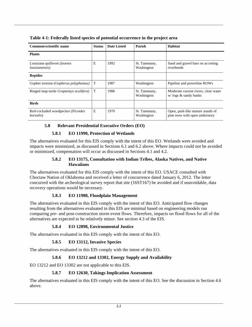
5-3
Table 4-1: Federally listed species of potential occurrence in the project area
Common/scientific name Status Date Listed Parish Habitat
Plants
Louisiana quillwort (Isoetes louisianensis)
E 1992 St. Tammany, Washington
Sand and gravel bars on accreting riverbends
Reptiles
Gopher tortoise (Gopherus polyphemus) T 1987 Washington Pipeline and powerline ROWs
Ringed map turtle Graptemys oculifera) T 1986 St. Tammany, Washington
Moderate current rivers, clear water w/ logs & sandy banks
Birds
Red-cockaded woodpecker (Picoides borealis)
E 1970 St. Tammany, Washington
Open, park-like mature stands of pine trees with open understory
5.8 Relevant Presidential Executive Orders (EO)
5.8.1 EO 11990, Protection of Wetlands
The alternatives evaluated for this EIS comply with the intent of this EO. Wetlands were avoided and impacts were minimized, as discussed in Sections 6.1 and 6.2 above. Where impacts could not be avoided or minimized, compensation will occur as discussed in Sections 4.1 and 4.2.
5.8.2 EO 13175, Consultation with Indian Tribes, Alaska Natives, and Native Hawaiians
The alternatives evaluated for this EIS comply with the intent of this EO. USACE consulted with Choctaw Nation of Oklahoma and received a letter of concurrence dated January 6, 2012. The letter concurred with the archeological survey report that site (16ST167) be avoided and if unavoidable, data recovery operations would be necessary.
5.8.3 EO 11988, Floodplain Management
The alternatives evaluated in this EIS comply with the intent of this EO. Anticipated flow changes resulting from the alternatives evaluated in this EIS are minimal based on engineering models run comparing pre- and post-construction storm event flows. Therefore, impacts on flood flows for all of the alternatives are expected to be relatively minor. See section 4.3 of the EIS.
5.8.4 EO 12898, Environmental Justice
The alternatives evaluated in this EIS comply with the intent of this EO.
5.8.5 EO 13112, Invasive Species
The alternatives evaluated in this EIS comply with the intent of this EO.
5.8.6 EO 13212 and 13302, Energy Supply and Availability
EO 13212 and EO 13302 are not applicable to this EIS.
5.8.7 EO 12630, Takings Implication Assessment
The alternatives evaluated in this EIS comply with the intent of this EO. See the discussion in Section 4.6 above.
6-1
6. EVALUATION
I have reviewed and evaluated, in light of the overall public interest, the documents and factors concerning this permit application as well as the stated views of other interested agencies and the concerned public. In doing so, I have considered the possible consequences of this proposed work in accordance with regulations published in 33 CFR Part 320 to 332 and 40 CFR Part 230. Comments received are addressed in Section 3.0 above. The following paragraphs includes how the project complies with the above-cited regulations.
6.1 Evaluation of Compliance with 404(b)(1) guidelines (restrictions on discharge, 40 CFR 230.10).
The alternatives evaluated in this EIS have been evaluated in accordance with the guidelines developed by the Administrator of the EPA in conjunction with the Secretary of the Army, and published at 40 CFR 230. The USACE has determined that the alternatives evaluated for this EIS comply with the Section 404(b)(1) guidelines. See Section 5.0 above for a summary of the 404(b)(1) analysis.
6.2 General Evaluation (33 CFR 320.4(a)):
6.2.1 The relative extent of the public and private need for the proposed work...
LADOTD stated that the proposed new roadway would divert traffic by providing an alternative north-south connection that could reduce congestion and delays for those traveling from northern St. Tammany Parish and Washington Parish to I-12. Reducing congestion and delays could increase safety by reducing the potential for accidents on existing routes (LA 41 and LA 21/LA 59/US 190 and could reduce travel time by routing through traffic around more populated areas. Reduced travel could then support and enhance potential economic development in northern St. Tammany and Washington Parishes.
6.2.1.1 Travel Time Benefits
The proposed project would provide moderate travel time savings on the new roadway between Bush and I-12. Some benefit to traffic congestion along the LA 21 and LA 59 corridors is expected with the diversion of traffic off the existing highways. However, improvements may be needed on existing intersections along LA 21 and LA 59 whether or not an alternative route is provided. Unacceptable Levels of Service are still expected at many of the intersections in the design year 2035.
6.2.1.2 Traffic Congestion Relief:
The proposed project would provide limited and, in most cases, short-term relieve of traffic congestion at most traffic intersections and roadway segments currently experiencing poor level of service. The amount of traffic improvement was dependent upon the alternative considered but all provided some level of short-term improvement. Those alternatives to the west provided better traffic relief for the highways located in the western part of the parish than those to the east and vice versa. With construction, the model predicts some slight improvement for some intersections for some of the alternatives. Before year 2035, traffic conditions are expected to worsen to preconstruction level of services.
No driver survey origin/destination studies were performed. Information regarding vehicular origin/destination areas within regional areas is contained in the TransCAD model. The Model indicated that all build alternatives would divert traffic from existing travel routes which would have limited improvement in the level of service and delay conditions. By design year 2035, the study estimates that the new alignments would divert between 8,170 to 13,020 vehicles per day dependent upon the alignment chosen to build.
However, the more traffic that is diverted, the more volume the alternative services and increased delay is expected at the intersections along the new route. Also, providing traffic relief at one intersection may
6-2
increase congestion at another. Traffic diverting to the new roadway would also be expected to increase traffic volumes along existing routes such as LA 435 and La 36. Modeling indicates increased use of these existing highways would likely result in greater delays at existing interchanges such as at the LA 435/LA 59 at LA 36 roundabout. While alternatives are expected to provide improvements in LOS and/or delay on the congested LA 21 and LA 59 corridors, unacceptable Levels of Service are still expected at many of the intersections in the design year 2035.
6.2.1.3 Improved Safety Conditions:
The proposed project is expected to produce minor safety improvements along the new highway. Existing highways would see minimal improvement without some future improvements not part of this project.
6.2.2 The practicability of using reasonable alternative locations and methods to accomplish the objective of the proposed structure or work...
LADOTD determined that upgrading either LA 21 or LA 41, existing highways in the project area, was practicable but would not provide the level of benefit that construction of a new highway on new alignment would have. Additionally, upgrading existing highways could unnecessarily impact residential and commercial properties along these existing routes. LA 41 currently is underutilized having sufficient capacity to provide an acceptable level of service (2010 traffic numbers indicated a LOS of A). Upgrading LA 21 to a four-lane roadway would improve safety, reduce congestion and provide some time savings. Only that portion of the traffic accessing I-12 interstate or the Lake Pontchartrain Causeway would still have to navigate US 190. US 190 has a level of service of F during peak rush hour traffic.
Of the other practicable alternatives considered, alternative Q was determined to have the least environmental impact.
6.2.3 The extent and permanence of the beneficial and/or detrimental effects that the proposed structures or work may have on the public and private uses to which the area is suited...
Benefits of the proposed project are at best minimal. The only potential benefit would be reduced travel time and safety for those motorists using the proposed roadway. Reduction in traffic congestion for highway segments along LA 21 and US 190 appears to be minimal with LOS remaining at or over capacity for all alternatives. Models indicated none of the alternatives would improve traffic congestion on the segment of LA 41/US 11 near Slidell. Economic information states that Bogalusa could possibly benefit from the improved transportation linkage in the long-term but the likely economic effects are dependent upon many other factors not related to the highway.
Alternative Q would result in long-term, serious, wide-scale, direct, secondary and cumulative regional impacts. The environmental consequences of constructing a new highway appear to be much greater than upgrading an existing facility. Without a mitigation plan that fully mitigates for unavoidable adverse impacts, the adverse impacts outweigh any benefits accrued by the proposed project.
Irreversible commitment of resources would be expected to result directly from construction of the proposed roadway because these resources would be expended in a way that could not be recovered once committed to the proposed project. They are:
1. A commitment of wetland resources with associated changes in drainage patterns that could not be reverse or retrieve.
2. Irreversible and irretrievable commitment of financial resources.
3. An undetermined volume of fuel, as well as other types of energy resources, would be expended during the construction of the proposed facilities
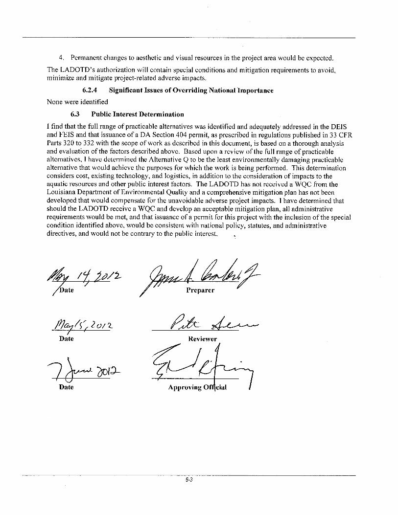
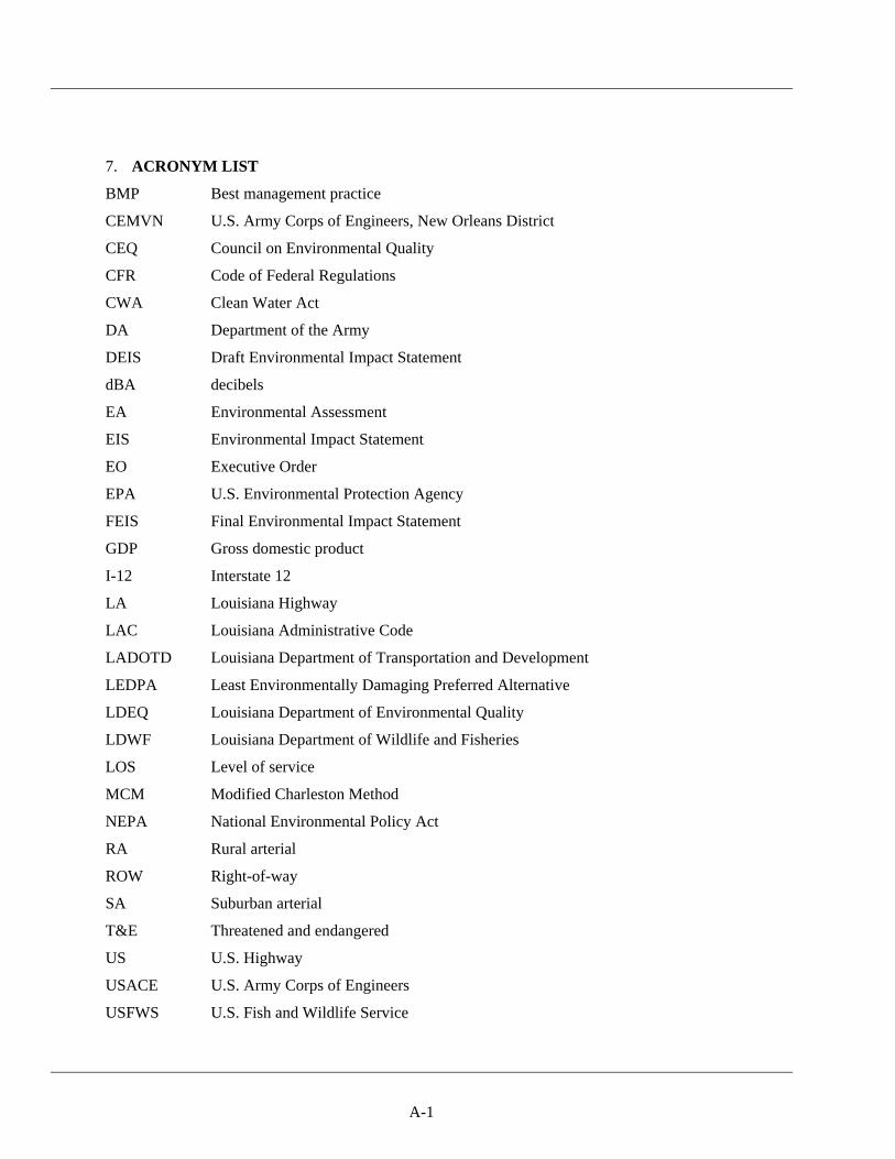
A-1
7. ACRONYM LIST
BMP Best management practice
CEMVN U.S. Army Corps of Engineers, New Orleans District
CEQ Council on Environmental Quality
CFR Code of Federal Regulations
CWA Clean Water Act
DA Department of the Army
DEIS Draft Environmental Impact Statement
dBA decibels
EA Environmental Assessment
EIS Environmental Impact Statement
EO Executive Order
EPA U.S. Environmental Protection Agency
FEIS Final Environmental Impact Statement
GDP Gross domestic product
I-12 Interstate 12
LA Louisiana Highway
LAC Louisiana Administrative Code
LADOTD Louisiana Department of Transportation and Development
LEDPA Least Environmentally Damaging Preferred Alternative
LDEQ Louisiana Department of Environmental Quality
LDWF Louisiana Department of Wildlife and Fisheries
LOS Level of service
MCM Modified Charleston Method
NEPA National Environmental Policy Act
RA Rural arterial
ROW Right-of-way
SA Suburban arterial
T&E Threatened and endangered
US U.S. Highway
USACE U.S. Army Corps of Engineers
USFWS U.S. Fish and Wildlife Service


![Army Corps Neg[1]](https://img.pdfslide.net/doc/110x75/577cde9a1a28ab9e78af7164/army-corps-neg1.jpg)