Embed Size (px)
Citation preview

INSTITUTE OF GEOLOGICAL SCIENCES
Natural Environment Research Council
SK17 0
Tideswell
Monyash 0
SK16
Alstonfield 0 SK15
SK27 0
Calver * D Bakewell
SK26
SK25 0 Wirksworth
0 Crown copyright 198 1 ISBN 0 11 8841 79 3"
SK37
Chesterfield 0
SK36 4
Clay Cross
S K35 Crich
Mineral Assessment Report 79
The limestone and dolomite resources of the country around Bakewell, Derbyshire
Description of 1 :25 000 sheet SK26 and part of SK27
D. McC. Bridge and J. R. Gozzard
Contributor J. I. Chisholm
London Her Majesty's Stationery Office 1981

PREFACE
National resources of many industrial minerals may seem so large that stocktaking appears unnecessary, but the demand for minerals and for land for all purposes is intensifying and it has become increasingly clear in recent years that regional assessments of resources of these minerals should be undertaken. The publication of information about the quantity and quality of deposits over large areas is intended to provide a comprehensive factual background against which planning decisions can be made.
Consultative Committee recommended that limestone should be investigated, and, following a feasibility study initiated in 1970 by the Institute and funded by the Department of Education and Science, the Industrial Minerals Assessment Unit began systematic surveys in 1972. The work is now being financed by the Department of the Environment and is being undertaken with the cooperation of members of the British Quarrying and Slag Federation.
This Report describes the limestone and dolomite resources of some 27 km2 of country around Bakewell, Derbyshire, shown on the accompanying 1 :25 000 resource map. The survey was conducted by Mr J. R. Gozzard under the supervision of Dr F. C. Cox; Mr D. McC. Bridge has been mainly responsible for the preparation of the report. Messrs D. J. Harrison, J. T. Dove, H. Mathers, T. Waterhouse and Mrs A. J. Stewart were also involved with the collection of basic data.
The assessment was based on a geological survey at the 1 : 10 560 scale by Messrs J. I. Chisholm, I. P. Stevenson, E. G. Smith, D. Price and R. A. Eden; dates of surveys are given on the resource map which is folded into the pocket at the end of this report. Mr Chisholm also contributed the account of the geology of the district.
Chemical analyses were determined by Mr A. E. Davis and Mr A. N. Morigi of the Institute’s Analytical Chemistry Unit. Mr K. S. Siddiqui provided X-ray diffraction analyses of the insoluble residues and petrographic slides were prepared by Mr M. Beasant.
I. C. Burgess, M. Mitchell and J. Pattison.
to provide statistical analyses and additional new programs were developed to aid the assessment; this work was carried out by Mrs S. Strachan and Mr J. Wheeler. Dr G. G. Baxter acted as systems analyst for the project.
The interdepartmental Mineral Resources
Palaeontological determinations were made by Messrs
The G-EXEC data-base management system was used
Mr C. L. Reeves, ARICS, (Land Agent) was responsible for negotiating access to land for drilling. The ready cooperation of landowners, tenants, quarrying and mining companies in the work is gratefully acknowledged.
G. M. Brown Director
Institute of Geological Sciences, Exhibition Road, London SW7 2DE
24 March 1981
The first twelve reports on the assessment of British sand and gravel resources appeared in the Report series of the Institute of Geological Sciences as a subseries. Report 13 and subsequent reports appear as Mineral Assessment Reports of the Institute.
Details of published reports appear at the end of this report.
Any enquiries concerning this report may be addressed to Head, Industrial Minerals Assessment Unit, Institute of Geological Sciences, Keyworth, Nottingham NG12 5GG
The asterisk on the cover indicates that parts of sheets adjacent to the one cited are described in this report.
11

CONTENTS
Summary 1 Introduction 1 Description of the district 3 Topography 3 Geology 5
Dinantian rocks 5 Dolomitisation 8 Mineralisation 8 Structure 8
Assessment of resources 8 Procedures 8 Classification 9 Purity 9 Rock chemistry 10 Non-carbonate mineralogy 14 Colour 15 Physical properties 16
Fracture spacing 16 Aggregate Impact Value testing 16
The resource map 17 Summary of resources 19 Block A 19 Block B 19 Appendix A: Classification and Glossary 2 I Appendix B: Explanation of format for borehole
Appendix C: Records of boreholes and sections 24 Appendix D: Analytical results 61 References 64
logs 22
FIGURES 1 Sketch map showing the location of the resource
2 Distribution of quarries and opencast mineral
3 Topography 4 4 Schematic section of the Monsal Dale Limestones
5 Dolomitisation and lead-zinc mineralisation within
6 Structure 8 7 Summary of the purity of each formation determined
8 Purity variations within the Monsal Dale and Eyam
9 Cluster analysis of chemical data 13 10 Variation of non-carbonate mineralogy with
1 1 Variation in mineral thickness across the limestone
12 Explanation of symbols used on graphical logs 23
sheet area 2
workings in the district 3
based on borehole and section data 6
Dinantian rocks 7
from insoluble residue data 9
limestones 1 1
formation 14
crop 18
TABLES 1 Classification of Dinantian rocks 5 2 Classification of limestones by purity 9 3 Summary of the chemistry of the main
lithostratigraphical divisions 12 4 Correlation matrix for selected samples from the
Monsal Dale Limestones 12 5 Summary of the chemistry of the Monyash-Matlock-
Brassington dolomites 15 6 Non-carbonate mineralogy determined by X-ray
diffraction 15 7 Distribution of rock colour 15 8 Summary of powder reflectance results for very high
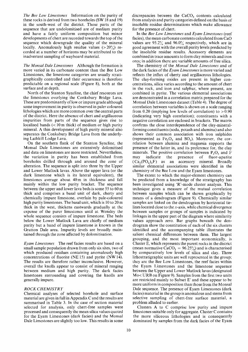
9 Summary of AIV results 17 10 AIV results for material from Shining Bank
1 1 AIV results for volcanic rocks 17 12 Classification of limestones 2 1
purity rocks 16
Quarry 17
MAP The limestone and dolomite resources of sheet SK 26 and part of SK 27 (Bakewell, Derbyshire) In pocket
111 .. .


The limestone and dolomite resources of the country around Bakewell, Derbyshire Description of 1:25 000 sheet SK 26 and part of SK 27
D. McC. BRIDGE and J. R. GOZZARD
SUMMARY
The study of samples from 11 cored boreholes, 19 major sections and 13 1 small exposures, together with infor- mation from the records and geological maps of the Institute, form the basis of the assessment of limestone and dolomite resources in the Bakewell area, Derbyshire. Five of the boreholes were drilled under contract for the Industrial Minerals Assessment Unit; the remainder were made available by industry.
The limestones have been classified on the basis of their calcium carbonate content, and the accompanying 1 :25 000 resource map shows the distribution of the recognised categories of limestone in the uppermost 10 m of strata, for which most information is available. Horizontal sections constructed from the borehole data and from knowledge of the regional geology, indicate the categories likely to be encountered below this depth.
Two resource blocks have been outlined and for each, the geology, the categories of limestones and the occurrences of other rocks are described. The results of investigations of chemical and mechanical properties are presented with outline borehole logs and the data are statistically analysed for the stratigraphical units de- scribed.
Bibliographic reference BRIDGE, D. McC. and GOZZARD, J. R. 198 1. The limestone and dolomite resources of the country around Bakewell, Derbyshire. Description of 1 :25 000 sheet SK 26 and part of SK 27. Miner. Assess. Rep. Inst. Geol. Sci., No. 79.
If it is desired to refer to the part of this report written by the contributor, the bibliographical reference shown above should appear in the list of references, and the citation in the text should take the form ‘Chisholm in Gozzard and Bridge ( 1 98 1 , pp 4-1 1)’.
Authors and contributor D. McC. Bridge, BSc, and J. R. Gozzard, BSc Institute of Geological Sciences, Keyworth, Nottingham NG12 5GG
J. I. Chisholm, MA Institute of Geological Sciences, Ring Road, Halton, Leeds LS 15 8TQ
INTRODUCTION
In recent years concern for environmental planning has made it clear that more detailed and comprehensive information on limestone resources is required. This information is needed to facilitate land-use and mineral planning by central and local government and to assist in the formulation of national policies to ensure continuing supplies to all industries for which limestone is an essential raw material. Ideally the information should relate to all the uses of this commodity ranging, for example, from crushing strength which relates to its use as aggregate, to trace-element composition, important in more specialised uses, for example, glass and steel manufacture. The provision of information on limestone resources is particularly important in regions such as Derbyshire and north Staffordshire which contribute significantly to the country’s production of raw materials and are noted also for their high scenic and amenity value. In 1978 the two counties produced 17 million tonnes of limestone from the Lower Carboniferous outcrop, representing 20% of national production (Institute of Geological Sciences, 1979); the cement, steel and chemical industries accounted for 41% of this tonnage, the remainder being used for constructional purposes. This report describes the resources along the eastern margin of the limestone crop, between Bakewell and Matlock and is one of a series of reports covering the region.
The methods of assessment embody the most cost- effective procedures for assessing limestone resources on a regional scale (Cox and others, 1977). The material for study has been obtained from cored boreholes, natural sections and quarry faces. The petrological, mineralogi- cal, chemical and certain of the physical properties of the samples have been determined in the laboratory. Con- ventional geological nomenclature is used for technical descriptions, ensuring compatibility between this report and the literature; a glossary is appended. The rocks are classified in terms of their calcium carbonate (CaCO,) content so that the relation between limestone purity and possible end-use may be deduced. Whilst detailed results are set out in the report and its appendices the accom- panying map is more generalised. Regional variation in limestone purity is shown averaged to a depth of 10 m. In the horizontal sections, the purity of the limestone to greater depths is inferred from knowledge of the local geology, augmented by the results from the boreholes and sections. The more detailed assessment of limestone within 10 m of the surface reflects the relative abundance and widespread distribution of data for this interval compared with a paucity for the more deeply buried strata.
1

Carboniferous l imestones
- M o t o r w a y s
Trunk roads -* Rai lways
Nat ional Park boundary
---- County boundar ies f 0 5 10 miles
IE3 Locat ion of main f igure
W
Figure 1 Sketch map showing the location of the resource sheet area.
2

1 );2[2 22/ 2'4 ( i6 27 2'8
Registered quarry sites are described in Appendix C
[ F l Limestone A619
e Working quarries
- Major mineral veins
PEAK DISTRICT
NATIONAL PARK A6 Major roads
Peak District national -..-.'' park boundary
HINING BANK
Figure 2 Distribution of quarries and opencast mineral workings in the district.
DESCRIPTION OF THE DISTRICT
Lying largely within the Peak District National Park (Figure l), the district is predominantly rural and is served by the towns of Bakewell and Matlock. The local economy is largely based on the agricultural and mineral extractive industries with tourism playing a subordinate role. In the past, lead mining was a major industry but activity is now confined to relatively small opencast operations for fluorite, calcite and barytes in Long Rake [2 10 6501 and Portaway Vein [230 6101. Limestone is exploited in two large quarries (Hall Dale and Shining Bank; Figure 2) and is of major importance in the building and road-making industries. Formerly a number of small quarries were worked for building stone and lime
' burning. The district is crossed by several main roads including the A6.
TOPOGRAPHY The Carboniferous limestones give rise to undulating
3
topography which rises to 282m (925 ft) near Over Haddon [204 6651 and 330m (1083 ft) at Blake Low [221 6031 near Elton. It is dissected by the steep-sided wooded valleys of Lathkill Dale and Bradford Dale (Figure 3). Between Elton [223 6101 and Winster [240 6051 the district is characterised by prominent dolomite tors in the form of isolated pinnacles and castellated escarpments. Here and in the neighbourhood of Alport [220 6451 spoil heaps from earlier lead and fluorite workings have further contributed to the scenery. Quarrying has also modified the topography in the central and eastern part of the limestone crop.
Elsewhere in the district Namurian sandstones and shales form scarp- and dip-slope features. The scarps rise to 323 m (1060 ft) on Stanton Moor and 366 m (1200 ft) on Beeley Moor. The rivers Wye and Derwent, which have their confluence near Rowsley [260 6551, flow through broad valleys.

over 1OOOft (305m)
800 - 1000 f t (244 - 305111) . . . . . . . . . . . . . . . . . . . . . . . . . . . .
600 -800 f t (183 - 2 4 4 m )
400 - 600 f t (122 - 183m) .......... ..........
below 4 0 0 f t (122m)
Main roads Rivers
ulutut’ Margin of limestone crop @ Built- up areas
0 1 2 miles I
1 I
2 A kilometres
Metric heights are given as rounded equivalents of the surveyed imperial measure in accordance with Ordnance Survey practice
Figure 3 Topography.
4

G E O L O G Y This general account is based mainly on geological investigations which are to be detailed in the forthcoming Buxton memoir (Aitkenhead and others, in preparation). The district is underlain by sedimentary and volcanic rocks of Carboniferous age. Limestones with interbedded volcanics form the lower part of the sequence and are succeeded upwards by mudstones and sandstones. The limestones were deposited in a shallow sea over a slowly subsiding ‘block’ of much older rocks, the gradual accumulation of sediment being interrupted at intervals by the eruption of basaltic lava with associated falls of tuffaceous material. Marked variations occur in the type of limestone, and in the proportion of limestone to volcanic rocks, within the district. Towards the end of Lower Carboniferous (Dinantian) times the deposition of limestones and volcanic rocks ceased and was succeeded by that of mudstones and sandstones, the outcrop of which now lies north and east of that of the limestones. For the most part these terrigenous sediments belong to the Upper Carboniferous (Namurian) Series, but the basal few metres are of Dinantian age and are termed the Longstone Mudstones.
Spreads of superficial deposits, dating from the Pleistocene ice age and later, cover parts of the district. On the limestone outcrops the main deposits are head, a reddish brown silt with chert fragments that attains a thickness of a few metres in hollows, and boulder clay. Along the major river valleys post-Glacial spreads of alluvium are commonly developed.
Dinantian rocks The stratigraphy of the Dinantian rocks of the district has been described by Trail1 (1940), Shirley (1950; 1959), Smith, Rhys and Eden (1967), and Butcher and Ford (1973). Additions and revisions to the sequences given by these authors have become necessary in the light of new information from borehole and surface surveys. A summary of the stratigraphical relationships as they are at present understood is given in the form of a generalised vertical section (see resource map folded into the pocket at the end of this report).
The Dinantian rocks are divided into five formations (Table l), mainly on the basis of lithology but also on the evidence of contained fossils. The formational names apply throughout the shelf province of the region and are based on the Wye valley section (Cope, 1933; Stevenson and Gaunt, 1971). In the south-eastern part of the district the formations are also known by local names (Table 1, column 5) and these have been used in Institute maps and memoirs (for example, Smith and others, 1967, p. 8). A generalised geological map of the Dinantian outcrop is incorporated in the resource map.
Table 1 Classification of Dinantian rocks
Woo Dale Limestones This formation does not crop out in the district and is not proved with certainty in boreholes. However, in adjacent areas, it consists of pale, chert-free calcarenites with bands of calcisiltite and calcilutite at the top, and it is assumed that these lithologies exist at depth beneath the district.
Bee Low Limestones Apart from a single small outcrop in Gratton Dale [202 6001 which is dolomitised, these limestones are known only from boreholes and mine workings.
Boreholes in the Gratton Dale area have proved 132 m of chert-free calcarenite beneath the Monsal Dale Limestones. The beds have not yielded any diagnostic fossils but they are assigned to the Bee Low Limestones on lithological grounds. The top of the sequence is marked by a calcarenite, rich in dasycladacean algal fragments, below which is a monotonous sequence of mid-grey and buff coloured thickly bedded calcarenites. Greenish grey and ochreous mudstone bands and clay wayboards occur at intervals throughout the succession and range in thickness from a few millimetres to over 0.5 m.
The upper part of the formation is also seen in Millclose Mine where limestones similar to those proved in the Gratton Dale boreholes have yielded Asbian faunas. One basaltic lava, the 144 Pumpstation Toadstone, has been proved in the upper part of this succession but is not seen to the south and west. Evidence from surrounding areas suggests that the proportion of volcanic rocks increases towards the east (Ramsbottom and others, 1962, pp. 138-140).
Monsal Dale Limestones This formation consists of interbedded limestones, lavas and tuffs, and ranges in thickness from 150 to 190m (Figure 4). Beds high in the sequence crop out over the northern and central parts of the district and are worked currently in Shining Bank Quarry; lower stratigraphical levels are exposed only on the southern limb of the Stanton Syncline.
The limestones are laterally variable but are mainly pale and medium grey coloured calcarenites with some calcirudites and calcilutites. A darker lithofacies forms the major part of the exposed sequence in the north-west of the district and is sufficiently well defined to be mapped as a separate unit. In the south, dolomitisation has destroyed much of the textural detail in the limestones close to the surface. However, there is evidence from borehole and mine workings for a thin, persistent dark grey limestone immediately above the Lower Matlock Lava and for a wedge of dark coloured limestone at the horizon of the Upper Matlock Lava where the latter is absent. Chert is common throughout the sequence, particularly in the darker lithofacies.
Stages Coral- Goniatite- Standard Local names brachiopod bivalve formational (Matlock area) zones zones names
Longstone Mudstones Cawdor Group Brigantian D, p2 ? Eyam Limestones ---
Monsal Dale Matlock Group Limestones
Asbian Dl Bee Low Limestones Hoptonwood Group early Asbian S,-Dl Woo Dale Limestones Griffe Grange Bed or Holkerian
5

m m all
a
-
E*
a
5
......... ......... ......... ......... ......... ......... ......... .........
\ u. L
P ,a cd
-a Y
rl .3
Y
2 W
5 W
?i
P
.*.k.,\, .... ....
'+ + + +' ' + +
&lC
,9
.... t ;+ + + +; ; + +
z:t;
t ,+
+ +
+, , +
+
.... 4U.m
\ \
v)
0
0
Y
v)
.e
8
I t
t
6

Volcanic products may exceed 50% of the total thickness of the sequence, particularly near the centres of eruption, the most important of which appears to extend from Alport [220 6451 eastwards towards Ashover beyond the sheet margin. Beds of lava and tuff related to this centre underlie the central and northern parts of the crop and are also recorded in Millclose Mine workings, where they interdigitate with the limestones before dying out southwards (Traill, 1940, pp. 198-203,205-207). The lavas also thin northwards and westwards, and there is an excellent example of this at an outcrop [204 6641 near Over Haddon. A second volcanic centre lies south of the district in the Matlock-Bonsall area, and its principal flows (the Upper and Lower Matlock lavas) extend northwards into the district. Both flows die out north- wards in the Millclose Mine workings (Traill, 1940, pp. 194-1 98,203-207).
Eyam Limestones These rocks are preserved around the margin of the Dinantian crop where they form a thin but distinctive veneer which rests disconformably on the Monsal Dale Limestones. They are mainly dark to medium grey, thinly bedded, cherty limestones with local developments of paler, unbedded or poorly bedded, knoll-reef limestone.
The knolls are found mainly in the lower parts of the sequence and occur scattered across the district, with the exception of the south-west. The largest knoll is known from the Millclose Mine workings and is 60 m thick and about 1 km across, but most are much smaller. The reef lithologies consist partly of pale, fine-grained limestone and partly of coarse-grained limestone, rich in crinoids and bryozoan debris.
The darker coloured limestones that surround the knolls and overlie all but the largest are generally between
215
70
69
68
67
1
- Major vein (rake)
- Minor vein
_____ Axis of Millclose orebody
.:.......:.::.T . . . Base of mudstone cover
0 1 2 3 km I I I
$6 i7 28 19
66
65
64
63
ti2
61
Figure 5 Dolomitisation and lead-zinc mineralisation within Dinantian rocks.
7

10 and 20m thick, but they exceed 40m in thickness locally, as for example near Alport [220 6451 and Snitterton [278 6031. Nodular and tabular cherts occur throughout the darker coloured lithofacies and are often associated with silicified shell debris.
Longstone Mudstones The Eyam Limestones are over- lain by a thick sequence of fossiliferous mudstones. The basal 10 to 20 m contain a Dinantian fauna and are distinguished by the name Longstone Mudstones. The remainder, up to 150 m thick, contain Namurian faunas.
Dolomitisation The limestones at outcrop have been altered to dolomite along the southern margin of the district (Figure 5). Parsons (1 922) provided the first comprehensive account of the extent and nature of the dolomitisation; more recently papers by Ford (1 969) and Ford and King (1 965; 1967) have described aspects of the dolomitisation relating to mineralisation and the development of silica sand pockets. The intensity of the dolomitisation varies locally and partially dolomitised limestones have gen- erally been included with more completely altered rock for mapping purposes. In detail, the margins of the alteration are irregular, and may be sharp or gradational. They commonly cut across bedding planes, showing that the dolomitisation took place after the lithification of the limestone. The alteration is a surface effect, as unaltered limestone has been proved to lie beneath the dolomite in several places. Recorded thicknesses of dolomite range up to 90 m.
Mineralisation The carbonate rocks in the district have been mineralised by fluids migrating from an inferred source at depth to the east. Most of the deposits are in near-vertical veins occupying joints or fault fissures, but there are also various less well-defined forms, including flats, pipes and irregular replacements, which are approximately hori- zontal or lie parallel to bedding.
The orebodies are composed mainly of calcite, barytes and fluorite with subordinate quantities of lead-zinc minerals, particularly galena and sphalerite. The largest veins, known as Long Rake and Coast Rake, trend east- north-eastwards across the district. Minor mineral veins are relatively abundant in the areas south of each rake, where they can be grouped into a dominant set trending approximately north-westwards and a subordinate set trending approximately north-eastwards (Figure 5) . Stratiform deposits mapped at the surface are virtually restricted to the dolomite crop and probably consist mainly of flats, with some veins.
The most important single orebody in the district was that formerly exploited at Millclose Mine (Traill, 1939). It consisted of a complex of veins with linked flats, pipes and cavern deposits, arranged in a series of layers beneath impervious beds (lavas, clay wayboards and the mud- stone cover) through the top 180 m of the limestone sequence. The overall shape of the orebody was linear along an approximately north-south axis.
Structure The Carboniferous rocks have been deformed by earth movements, mainly during late Carboniferous and early Permian times, but also probably during the Tertiary; the folds and faults that resulted are shown in Figure 6. The dominant structure is the regional north-eastward dip away from the Derbyshire ‘Dome’, which takes the
8
limestones beneath the mudstone cover in the east of the district. Superimposed on the regional dip are small periclinal and basinal structures with various axial trends. The largest of these is the Stanton Syncline, an asym- metrical downfold, aligned approximately west-east, which has a relatively steep southern limb with dips exceeding 30’ locally. The only other well-defined structures are the Magshaw and Bakewell anticlines.
The main faults are the pair of east-north-eastward- trending rakes, which have throws of up to 20m; a number of other fractures showing no preferred orien- tation and, with no significant associated mineralisation, occur in the north of the district.
Figure 6 Structure.
ASSESSMENT OF RESOURCES
P R O C E D U R E S The various techniques and procedures adopted for the assessment survey evolved from a feasibility study which was carried out in an adjacent district (Cox and others, 1977).
Field programme The sampling programme was plan- ned on the basis of modern 1: 10 560-scale geological maps. Four boreholes were drilled to a depth of l00m using a wireline system for core recovery and water-flush circulation; a fifth was drilled using airflush and termi- nated at 34m depth. Continuous cores with a minimum diameter of 47mm were obtained. In general, core recovery exceeded 90% but some difficulties were en- countered with cherty limestone, dolomite and clay bands. Cores from six commercial boreholes were also made available. All major quarries and natural sections in the area were sampled at one-metre intervals and supplementary spot-samples were collected from smaller exposures.
Laboratory programme All the cores and face-sampled material were sawn, acid-etched and then logged with the aid of a binocular microscope. The purity of limestone

100-
s 5 50-
2
> 0
3 D
U
100
8 >. 0
50 3 CT
U 2
( 195 determinations)
5 4 3 2 1 Purity categories
Monsal Dale Limestones (549 determinations)
5 4 3 2 1 Purity categories
1
(69 determinations)
5 4 3 2 1 Purity categories
Bee Low Limestones (139 determinations)
Purity categories
Purity categories:
1 Very high purity (2 98.5% CaC03)
2 High purity (2 97 to c 98.5% CaC03)
3 Medium purity (2 93.5 to e 97% CaC03
4 Low purity (285 to 93.5% CaC03)
5 Impure (e 85% Ca C03 1
Note: Dolomitised rocks not included
Figure 7 Summary of the purity of each formation determined from insoluble residue data. Dolomitised rocks are not included.
The purity categories are: 1 Very high purity (2 98.5% CaCO,) 2 High purity (297.0 to < 98.5% CaCO,) 3 Medium purity (393.5 to <97.0% CaCO,) 4 Low purity (2 85.0 to < 93.5% CaCO,) 5 Impure (<85.0%)
Table 2 Classification of limestones by purity
Category CaCO, Equivalent Possible uses percentage CaO
1 Very high 3 98.5 3 55.2 Steel, glass, rubber, purity plastics, paint,
2. High 397 to 3 54.3 to Iron, ceramics, whiting
purity < 98.5 < 55.2 Portland cement, sugar
3 Medium 393.5 to 3 52.4 to Paper, animal purity <97 < 54.3 feeding stuffs,
agriculture 4 Low 3 8 5 to 347.6 to Aggregates
purity < 93.5 < 52.4 5 Impure < 8 5 < 47.6 Natural cement,
mineral wool
Note CaCO, content is only one of several chemical specifications governing end-use; silica, iron, sulphur, and certain trace elements may be as important in some applications.
was determined by measuring the quantity of acid- insoluble residue. Determinations were carried out at one-metre intervals using a rapid but accurate filtration method (Molinia, 1974) and the chief constituents in the residues were identified by semiquantitative X-ray diffractometry. Chemical analyses for major and trace
elements were performed on selected samples by the Analytical Chemistry Unit of the Institute using methods previously described (Roberts and Davis, 1977). Tests were also performed to monitor colour variation and the mechanical properties of the rock.
CLASSIFICA TION Limestones may be classified in a variety of ways (Ham, 1962), but the two methods chosen for use in this report are based on petrology (see Appendix A) and on CaCO, content. The former is used to describe the rocks in lithological terms, but the latter is preferred for dem- onstrating the variation in chemical grade of the resource. The relationship between the five chemical grades adopted, their CaCO, contents and possible end-uses is shown in Table 2.
PURITY The grades of mineral present throughout the district were determined by grouping the insoluble residue results at each sample site into sets covering successive 10-m intervals and then calculating an average purity for each interval (see section on ‘Carbonate resource information’ for details of calculation). This value then determined the category of the limestone according to the classification in Table 2.
Figure 7 shows the frequency with which these different categories occur within each of the mapped divisions and is based on 952 residue determinations.
9
The Bee Low Limestones Information on the purity of these rocks is derived from two boreholes (SW 18 and 19) in the south-west of the district. Those parts of the sequence that are undolomitised are of medium purity and have a fairly uniform composition but minor developments of chert are recorded towards the top of the sequence which downgrade the quality of the mineral locally. Anomalously high residue values (> 20%) re- corded at a number of horizons may be attributed to the inadvertent sampling of wayboard material.
The Monsal Dale Limestones Although the formation is more varied in its carbonate content than the Bee Low Limestones, the limestone categories are usually strati- graphically controlled and their occurrence is therefore predictable on a regional scale (Figure S), both at the surface and at depth.
North of the Stanton Syncline, the chief resources are the limestones overlying the Conksbury Bridge Lava. These are predominantly of low or impure grade although some improvement in purity is observed in paler coloured lithologies which are more common over the central parts of the district. Here the absence of chert and argillaceous impurities from parts of the sequence gives rise to localised bands (< 10 m thick) of medium or high purity mineral. A thin development of high purity mineral also separates the Conksbury Bridge Lava from the underly- ing Lathkill Lodge Lava.
On the southern flank of the Stanton Syncline, the Monsal Dale Limestones are extensively dolomitised and data on limestones are more restricted. Nevertheless, the variation in purity has been established from boreholes drilled through and around the zone of alteration. The sequence is split into three by the Upper and Lower Matlock lavas. Above the upper lava (or the dark limestone which is its lateral equivalent), the limestones average about 40m in thickness and fali mainly within the low purity bracket. The sequence between the upper and lower lava beds is some 55 to 60 m thick and comprises a basal unit of dark, cherty and chemically impure limestone, overlain by pale-coloured high purity limestones. The basal unit, which is 10 to 20 m thick in the west, thickens eastwards gradually at the expense of the purer limestones until at Wensley the whole sequence consists of impure limestone. The beds below the Lower Matlock Lava are chiefly of medium purity but a band of impure limestone is known in the Gratton Dale area. Impurity levels are broadly main- tained through the zone affected by dolomitisation.
Eyam Limestones The reef facies results are based on a small sample population drawn from only six sites, two of which produced residues containing anomalously high concentrations of fluorite (NE 15) and pyrite (NW 14). The results are therefore rather inconclusive. However, overall the knolls appear to consist of mineral ranging between medium and high purity. The dark facies limestones surrounding and covering the knolls are generally impure.
R O C K C H E M I S T R Y Chemical analyses of selected borehole and surface material are given in full in Appendix C and the results are summarised in Table 3. In the case of section material selected for analysis, only chert-free samples were processed and consequently the mean silica values quoted for the Eyam Limestones (dark facies) and the Monsal Dale Limestones are slightly too low. This results in some
discrepancies between the CaCO, contents calculated from analysis and purity categories defined on the basis of insoluble residue determinations which make allowance for the presence of chert.
In the Bee Low Limestones and Eyam Limestones (reef facies), the mean carbonate contents calculated from CaO values are 95.2% and 96.0% respectively, which are in good agreement with the overall purity levels predicted by the insoluble residue results. Accessory elements are combined in trace amounts to form clay minerals and iron ores; in addition there are variable amounts of free silica.
The chemistry of the Monsal Dale Limestones and of the dark facies of the Eyam Limestones is more varied and reflects the influx of cherty and argillaceous lithologies. The clay-forming oxides are present in higher con- centrations, silica varies according to the amount of chert in the rock, and iron and sulphur, where present, are combined in pyrite. The various elemental associations are demonstrated in a correlation matrix prepared for the Monsal Dale Limestones dataset (Table 4). The degree of correlation between variables is shown on a scale ranging from 0.20 (implying low levels of correlation) to > 0.90 (indicating very high correlation); constituents with a negative correlation are enclosed in brackets. The matrix confirms the close interdependence of the clay-mineral- forming constituents (soda, potash and alumina) and also shows their common association with iron sulphides (represented as Fe203 and SO,). Moreover, the cor- relation between alumina and magnesia supports the presence of the latter in, and its preference for, the clay minerals. The positive correlation between P20, and F may indicate the presence of fluor-apatite (Ca,(PO,),F) as an accessory mineral. Broadly similar elemental associations were identified in the chemistry of the Bee Low and the Eyam limestones.
The extent to which the major-element chemistry can be predicted from a knowledge of the stratigraphy has been investigated using ‘R’-mode cluster analysis. This technique gives a measure of the mutual correlation between samples which can be shown graphically by means of a dendrogram (Figure 9). Chemically similar samples are linked on the dendrogram by horizontal tie- lines located close to the x-axis, while chemical divergence between samples or groups of samples is indicated by linkages in the upper part of the diagram where similarity values approach zero. Bar graphs beneath the den- drogram show the constitution of each of the six clusters identified and the accompanying table illustrates the salient chemical differences between them. The largest grouping, and the most important economically, is Cluster E, which represents the purest rocks in the district (mean normative CaCO, = 96.25%) and is characterised by comparatively low levels of silica and clay. Three lithostratigraphic units are well represented in the group; they are the Bee Low Limestones, the reef facies within the Eyam Limestones and the limestone sequence between the Upper and Lower Matlock lavas (designated Mo< URB on Figure 9). Samples from the first two units are restricted mainly to Subset E’ and these appear to be more uniform in composition than those from the Monsal Dale sequence. The presence of Eyam Limestones (dark facies) material in the group is anomalous and stems from selective sampling of chert-free surface material, a problem alluded to earlier.
Clusters A to C comprise low purity and impure limestones suitable only for aggregate. Cluster C contains the more siliceous lithologies and is consequently dominated by samples from the dark facies of the Eyam
10

Vertical scale (met res)
- 0
-
-
-
-
- 50
-
-
-
-
- 100
20
NW 12 NW 13
NW 4 k ) &
NW 14 SW 36 ........... .............
25 30 I
2 - 0 1 2 3 k m
I Borehole locations 0
Limestone outcrop
70
55
60
$ + + +
+ + + + + +
Limestone Dolomite and dolomitised (see text) limestone
Category of limestone
n Shale and mudstone
v ricoloured (wayboard) c7a ys
[ z Basaltic lava I 1 I 1 1 I Reef limestone
37
23
Lower Mirtlock Lava
Upper Mat lock Lava
Figure 8 Purity variations within the Monsal Dale and Eyam limestones.

Table 3 Summary of the chemistry of the main lithostratigraphical divisions
Lithostratigraphical percentages parts per million divisions (with number OfanalYses) CaO MgO Loss on SiO, Al,O, Na,O K,O SO, P,O, F Fe,O, MnO Pb Zn Cu As*
ignition
EYAM Mean 53.80 0.26 41.61 0.39 0.21 0.03 0.06 0.39 0.06 0.67 1223 325 Mean 53 53 5 -
LIMESTONES? S.D. 1.39 0.08 2.84 0.68 0.19 0.01 0.03 0.68 0.03 1.60 961 143 Maximum 270 190 5 4
------ -- ----- ----
Reef facies 2.7 32.3 7.2 183.0 95.0 35.0 52.5 183.0 52.5 250.7 8.2 46.2 (6; 119 -+I 1.46 0.08 2.98 0.71 0.20 0.01 0.03 0.71 0.03 1.68 101 150
------ ------- Dark facies Mean 46.89 0.51 36.62 16.19 0.70 0.04 0.13 0.37 0.09 0.04 3006 372 Background < 3 60 5 -
----
(25; 4) ci S.D. 10.39 0.40 8.01 18.69 2.31 0.02 0.34 0.81 0.10 0.06 7239 500 Maximum 480 460 30 3 +x$ 8.7 30.7 8.6 45.3 129.4 19.6 102.5 85.8 43.6 58.8 94.4 52.7 %$ 4.07 0.15 3.14 7.32 0.91 0.01 0.13 0.32 0.03 0.02 2838 196 ------- - -----
MONSAL Mean 51.00 0.41 39.83 8.04 0.38 0.04 0.09 0.23 0.05 0.05 2447 231 Background < 3 40 5 - DALE S.D. 4.59 0.19 4.70 10.03 0.79 0.01 0.14 0.26 0.04 0.09 3595 177 Maximum 2000 1000 35 4 LIMESTONES? * %$ 2.2 11.5 2.9 31.1 51.7 6.2 38.7 28.1 19.9 44.8 36.6 19.1
(62; 18)s + $ 1.14 0.05 1.17 2.50 0.20 0.00 0.03 0.06 0.01 0.02 895 44
----
BEE LOW Mean 53.35 0.49 42.40 2.91 0.13 0.03 0.05 0.12 0.01 0.01 1078 260 Background < 3 20 5 -
LIMESTONES? S.D. 1.32 0.37 1.14 1.91 0.09 0.00 0.02 0.15 0.01 0.02 1023 178 Maximum 170 140 10 7
-- ---- --- ---- ----
(16; 5) 3 -+x$ 1.3 40.2 1.4 35.0 36.9 - 21.3 66.6 53.3 106.6 50.6 36.5 * $ 0.70 0.20 0.61 1.0 0.04 - 0.01 0.08 0.01 0.01 545 948 -------------
DOLOMITES 1 1 Mean 31.72 19.82 46.37 1.70 0.05 0.05 0.03 0.04 0.04 0.17 2925 875 Mean 47 272 11 -
----
(4; 0) 9 S.D. 1.09 0.10 1.05 1.59 0.08 0.01 0.01 0.05 0.01 0.20 917 88 Maximum 160 430 15 - +x$ 5.5 0.8 3.6 148.8 254.6 31.8 53.0 198.9 39.8 18.7 49.9 16.0 -+: 1.73 0.16 1.67 2.53 0.13 0.02 0.02 0.08 0.02 0.03 1459 140
* The background value of As, determined for the complete data set is < 2 parts per million. t Excluding dolomitised samples. 1 Confidence limits at the 95% probability level. 4 The first figure denotes the number of samples analysed for all constituents other than As; the
1 1 Rocks containing over 90% dolomite mineral.
S.D. denotes 'standard deviation'.
second figure denotes the number of samples analysed for As.
Table 4 Correlation matrix for selected samples from the Monsal Dale Limestones
Element/ Correlation coefficients (based on a dataset of 62 samples; constituents in brackets have a negative correlation) oxide
CaO
SiO,
'3
K2O
Na, 0 Fe2 '3
Pb
Zn
MnO
F
0.20-0.30 0.30-0.40 0.40-0.50 0.50-0.60 0.60-0.70 0.70-0.80 0.80-0.90 > 0.90
(SO,) MnO, ( 4 0 3 , (Si021 K20, P20s)
so,, K,O, A1203 p,o,, (MnO)
Pz OS SiO,, (CaO), MgO Na,O, Fe,O, SO, K2O Cu, Zn, F
SiO,, (CaO), F MgO Fe2 '3 SO,, Na,O '3
Cu, Zn c u p 2 0 5 Zn, F MgO, Fe,O, SO,, Al,O, K,O Pb p, o s , c u F so,, N a p ,
Mgo, K,O, Zn
SiO,, A1,0,, MgO Zn, F Fe2 '3 Na,O A1203, K2°
(CaO) Zn, MnO SO,, F Fe,03, Al,O,, Na,O
K, 0 L.
SiO,, AL,03, Na,O, (CaO), F Fe,03, MnO Cu, Zn
SO,, Zn, Pb P,Os, MnO
c u
Na20, K,O, A1203,
> Fe2 O3 9 F
F, K,O, P20s SO,, Na,O, Fe,O,, Pb '3
Cao, p2°5, Na20,
(MgO) K,O, CUI SO,, MnO, Na,O, Fe,03, P,OS K,O, Pb Al,O,, Cu, Zn
12

c w
CLUSTERS >
100-
% of samples from 50 each formation i i--
mean (X) 0 0 4 0.75 0.31 3680 6.11 5052 6
A d f i ~ ~ ~ ~ l r ) 0.01 1.01 0.34 2600 4.18 2.49
F 0.10 1.10 4 4 3 18170 18.09 41.71
B u 9
0.09 0.89 3.58 8850 13.48 9.86
C F
0.04 0 60 0.24 1470 12.60 6.10 U
0.07 0 5 1 0.26 1510 27.98 41.85 22
63
I I I I I I I
F 0.14 0.47 0.29 1860 3.81 49.60
F u 0.09 0.14 0 18 1260 2.88 1.62 13
I I I I I I I
Dlagnostlc Features
~
High levels of slllca, clay and pyrlte
Hlgh levels of slllca
Magneslurn- rich rocks
Low levels of
slllca and clay
Hlgh levels of P205
D - Dolomltes and
dolomltlc hmestones
1 i
BLL Bee Low Llmestones
M~ (CBB) Monsal Dale Llmestones (north of Stanton Syncline)
Matlock Lava)
Matlock Lava)
Mo (>URB) Monsal Dale Llmestones (overlying Upper
Mo Monsal Dale Limestones (underlylng Upper
EyL Eyam Limestones (dark facies)
K Eyam Llmestones (reef fames)
F
m w - -
Figure 9 Cluster analysis of chemical data.

Limestones and from the more northerly outcrops of the Monsal Dale Limestones. It is significant that strati- graphically equivalent Monsal Dale Limestones material (designated > URB on Figure 9) from the south of the district is not included in this cluster but occurs in the purer clusters E” and F, thus supporting the view expressed earlier that silica levels decrease towards the south. Clusters A and B are distinguished primarily on account of their high Fe,O, contents while Cluster D is made up of the various dolomitised samples.
It is evident from the distribution of the samples within the dendrogram that the clusters have both stratigraphi- cal and economic significance and the analysis confirms that the exploration targets for medium or high purity mineral are those identified by the insoluble residue study.
Boreholes were sited away from known mineral veins so that trace element concentrations would be likely to approximate to background levels. Nevertheless anom- alously high levels of lead (up to 2000 ppm) were detected in some of the samples analysed. Frequency distribution curves were plotted for copper, lead, zinc and arsenic where there were sufficient data and in each case, the modal value was selected as the best estimate of background concentration (Table 3). Most of the trace elements show no consistent regional pattern, but there is some evidence that in the Monsal Dale Limestones, the metals copper, lead and zinc have a strong affinity for the clay-forming elements (Table 4).
A detailed study of the chemical variation along the dolomite belt has not been undertaken because of the restricted geographical and subsurface occurrence of dolomite within the resource sheet area. Evaluation of the dolomites is further complicated because the rocks are chemically varied and have been affected by several phases of silicification and calcification. Of the 9 samples analysed, 4 contain more than 90% dolomite mineral (MgO > 19.68%), the remainder range from calcitic dolomites (MgO 10.93 to 19.68%) through to dolomitic limestones (MgO 2.19 to 10.93%). The chemistry of, the ‘commercial grade’ dolomites is summarised in Table 3.
Analytical data on the dolomitised rocks in adjacent areas have already been published (Cox and Bridge, 1977; Cox and Harrison, in press) and, since this report concludes the assessment of these rocks, it is appropriate to review the chemistry of the Mat lock - Monyash-Brassington dolomite belt as a whole (Table 5).
The majority of the samples analysed are dolomites or calcitic dolomites with dolomitic limestones only poorly represented towards the margins of the alteration zone. Chemical variation across the belt reflects, in part,
compositional differences inherited from the parent rocks. Thus the Eyam and Monsal Dale limestones, which are typically more siliceous and argillaceous than the Bee Low Limestones, give rise to dolomites contain- ing higher levels of silica, potash, alumina and soda. The main elements introduced during dolomitisation in addition to magnesium, are iron and manganese whose abundances are increased to four times and twice their original abundances respectively. Both elements sub- stitute in the calcite and dolomite lattices. Manganese also occurs as the oxide, pyrolusite. Trace-element levels of copper, lead and zinc are comparable with background levels recorded in unaltered limestones.
N O N - C A R B O N A T E M I N E R A L O G Y The non-carbonate fractions of the rocks were examined microscopically in reflected light and representative samples were selected for X-ray diffraction analysis. This examination showed that silica and clay minerals account for more than 90 per cent of all residues with pyrite, limonite, barytes, fluorite, unidentified ore minerals and hydrocarbon recorded in minor or trace amounts. The proportions of the three most commonly occurring non- carbonate minerals in each formation are shown in Figure 10.
Silica is present in the form of euhedral quartz crystals, as cryptocrystalline replacements of shell structures, and as chert. Crystals are scattered throughout the sequence, but, where concentrated locally, they may increase the insoluble residue by between 2 and 3 per cent. Fossil debris may be partially or completely replaced by silica giving rise to abundant insoluble residues. Brachiopods are most susceptible to replacement, but silicification of all the main fossil groups has been recorded. Chert is mainly restricted to certain parts of the Monsal Dale and Eyam Limestones; its surface distribution based on field and borehole observations is shown on the resource map. Rocks containing combinations of the various forms of silica are common.
Clay occurs in stratified deposits, in joints, and as mineral disseminations within limestone. The stratified deposits, termed wayboards, are ochreous grey and may exceed 0.3 m in thickness. A full discussion of their composition and mode of origin is given by Walkden (1 972; 1974). Disseminated clay minerals are most widely developed within the darker coloured limestones of the Monsal Dale and Eyam limestones. The various clay mineral groups that have been identified are listed in Table 6. Kaolinite and illite appear to be more common in the Monsal Dale Limestones, possibly as a result of
Monsal Dale Limestones
Monsal Dale Eyam Limestones Eyam Limestones Limestones Bee Low Limestones
facies) (dark facies) (dark facies) (knoll-reef facies) (pale and mid-grey
r l FJ .... . .... . : .. .. . .. .... .
Quartz Clay Pyrite
Figure 10 Variation of non-carbonate mineralogy with formation (percentages from optical examination of insoluble residues).
14

Table 5 Summary of the chemistry of the Monyash-Matlock-Brassington dolomites
Lithostratigraphical percentages by weight partsper million divisions (with number of analyses) MgO CaO Fe,O, Al,O, SiO, NA,O K,O SO, P,O, F Lossat Cu Pb Zn MnO As
1050' C
DOLOMITISED Mean 19.72 31.47 0.31 0.10 2.75 0.05 0.03 0.02 0.04 0.16 46.00 15 35 250 860 1 MONSAL S.D. 1.52 1.70 0.1 1 0.19 4.21 0.02 0.02 0.02 0.04 0.33 2.39 15 55 180 200 1 DALE LIMESTONES Maximum 21.34 34.10 0.63 1.01 19.70 0.06 0.11 0.05 0.17 1.30 47.75 60 180 580 1270 3
(29) * Minimum 15.60 27.00 0.18 0.00 0.19 0.01 0.01 0.00 0.00 0.00 37.03 5 0 20 490 0
DOLOMITISED Mean 18.74 32.62 0.35 0.03 0.19 0.03 0.02 0.06 0.60 0.04 47.32 5 490 260 1250 1 BEE LOW S.D. 2.57 2.94 0.16 0.05 0.24 0.02 0.02 0.21 0.05 0.18 0.81 5 2100 780 510 1 LIMESTONES Maximum 21.10 42.10 0.68 0.20 1.04 0.05 0.05 1.00 0.22 0.85 48.21 15 10100 3800 2800 2
(23) 1- Minimum 10.50 29.30 0.13 0.00 0.00 0.00 0.00 0.00 0.01 0.00 45.12 0 0 20 620 0
* The numbers of analyses for SO, and As were 13 and 7 respectively. 1- The number of analyses for As was 6.
S.D. denotes standard deviation.
increased volcanic activity. Clay minerals also form as residual deposits infilling stylolitic sutures.
Finely divided pyrite is scattered throughout the limestone sequence but is more common in the darker limestones and in those associated with igneous rocks. An apparent concentration in knoll-reef limestones (Figure 10) is due to an abundance of pyrite recorded at one locality (NW 14). Iron oxides occur as alteration and weathering products after pyrite, commonly staining fissures and fractures. Barytes, fluorite and hydrocarbon are recorded in residues from rocks adjacent to hy- drothermal veins.
SK 16
Dinantian .. outcrop
Mat lock - Brassin ton; Monya.si( dolomites COLOUR
Quantitative colour determinations are important for limestones which are intended for use in the production of whiting, glass and paper. Measurements of tri-colour reflectance (Cox and others, 1977) were made using an EEL reflectance spectrophotometer calibrated against a white standard (magnesium carbonate). The measure- ments were taken on sawn, acid-etched rock surfaces and on powder discs. The etched surface colour gives an objective value which can be used in correlating boreholes and sections. Additionally, it is a general guide to the likely category of the limestone, although some spar- cemented rocks with high carbonate contents may give low reflectance readings.
Locat ion of main dolornitised zones
Table 6 Non-carbonate mineralogy determined by X- ray diffraction.
~
Minerals identified
~ ~~~ ~~
Eyam Limestones ~ ~~
Monsal Dale Lime- stones
Bee Low Lime- stones
Dark Knoll- facies reef
facies X X X X X X X
Table 7 Distribution of rock colour Quartz Kaolinite Illite Montmorillonite Chlorite Muscovite Mixed-layer clay
Pyrite Siderite Hematite Geothite Marcasite Fluorite Barytes Ankerite
X X X
X X X Formations and
subdivisions percentages
Pale Mid- Dark grey" greyt grey$ -~
8 51 41
X X
EYAM Dark LIMESTONES lithofacies X
X X X X
X
X X X
X --- 24 72 4 Reef
facies --- 14 46 40 MONSAL DALE Dark
LIMESTONES lithafacies X
X --- 21 73 6 X
X X
Normal lithofacies ---
1 1 87 2 X 10 4
BEE LOW LIMESTONES Number of samples analysed
35 8 * Reflectance > 35% at 660 nm, > 26% at 520 nm, > 24% at 470 nm. t Reflectance 35-15% at 660 nm, 26-12% at 520nm, 24-1 1% at 470nm. $ Reflectance < 15% at 660 nm, < 12% at 520 nm, < 1 1 % at 470 nm.
15

Table 8 Summary of powder reflectance results for very high purity (CaCO, 3 98.57/,) rocks
Borehole/ Formation* (and Maximum Mean reflectance Section stratigraphical continuous percentage (and standard number (with subdivision thickness deviation) number of sampled of very samples high purity 660nm 520nm 470 nm determined) mineral SE 1s (26) EyL, K, Mo
(> URB) 7 78 ( 5 ) 72(5) 69(5) SE 3s (1 5 ) EyL, K 5 75(9) 70(10) 68(10) NW 14(18) K, Mo(>CBB) 8 80 (3) 76 (4) 74(4) NW 5s (7) Mo (> CBB) 3 80 (6) 69 (3) 67(4) SW 36 (1 5 ) Mo (> CBB) 5 82 (2) 76 (2) 74(2) NW 13 (10) Mo (< CBB > LOB) 6 80 (2) 73 (3) 72 (4) SW lS(17) Mo(<LRB) 6 68 (4) 60 ( 5 ) 57 (4) SW 37 ( 1 1) Mo (< URB) 6 80(l) 76 (2) 74(2) SE23 (21) Mo (< URB) 1 1 79 (3) 73 (3) 71 (3) * EyL = Eyam Limestones (dark facies) K = Eyam Limestones (reef facies) Mo = Monsal Dale Limestones
~~~
> CBB = Beds above the Conksbury Bridge Lava < CBB > LOB = Beds between the Conksbury Bridge and Lathkill Lodge lavas > URB = Beds above the Upper Matlock Lava < URB = Beds between the Upper and Lower Matlock lavas < LRB = Beds below the Lower Matlock Lava
The limestones exhibit various shades of grey which are defined by reference to three filters with wavelengths of 660, 520 and 470nm respectively (Cox and others, 1977, p.7), the percentage distribution of these shades based on over 1 100 etched-surface measurements is given in Table 7. Dark grey limestones are mainly restricted to the thin- bedded Eyam Limestones and to the dark facies of the Monsal Dale Limestones; a dark grey limestone also occurs directly above the Lower Matlock Lava. The dark coloration of the rocks may be related to volcanic events outside the district. Mid-grey limestones are represented in each formation but are best developed in the Bee Low Limestones, which show a high degree of uniformity of colour. In contrast, pale grey colours typify the reef- Knolls and purer parts of the Monsal Dale Lime- stones.
Powder discs (Cox and others, 1977) were prepared for all samples falling within the very high purity category. The reflectance results (Table 8) show that the whitest powders come from thin, very high purity bands within the upper part of the Monsal Dale Limestones. A maximum value for the dataset of 88% is recorded in SE 3s but, in general, the limestones are less white when powdered than stratigraphically equivalent beds out- cropping west of the district (Cox and Bridge, 1977).
P H Y S I C A L P R O P E R T I E S
Fracture spacing One of the most important properties which determine the engineering quality of a rock is its continuity; rock masses transected by faults, joints and bedding planes are inherently weaker and less stable than larger blocks with few fractures. One method of quantifying fracture and joint spacing, which is particularly applicabie in dealing with borehole core is to use the Fracture Spacing Index (Franklin and others, 1971). This index, denoted by the symbol ‘If, is defined as the length of a unit, divided by the number of fractures within the unit. The index has been used to assess the rock quality of some of the cores drilled for the assessment study and results are shown graphically in Appendix C. Fracture indices for all the
16
limestones commonly fall between 200 and 1000 mm. The mean value for the Monsal Dale Limestones is 740mm, which is consistent with the thickly bedded nature of these rocks. The mean indices for the other formations are 370mm for the Eyam Limestones, dark facies and 700 mm for the Eyam Limestones, reef facies.
Aggregate Impact Value testing In order to assess the performance of the rocks as aggregates, IO-m lengths of halved core were crushed, sub-sampled and tested. Following the work of Ramsay and others (19733, who showed that an unknown component of additional energy is introduced by the rebound of the hammer when the test machine is mounted on a concrete base, the Institute substituted a wooden base, in an attempt to eliminate this potential source of error. Although the results obtained using this modified procedure are internally consistent, the values are not directly comparable with results from other laboratories. Consequently, the procedure laid down in British Standard 8 12 (British Standards Institution, 1975) has been re-adopted. Aggregate impact values (AIV) ob- tained with the machine mounted on a wooden base have been corrected in this report to equivalent ‘British Standard values’ using an experimentally determined conversion factor. The corrected results are shown graphically for individual boreholes in Appendix C and are summarised in Table 9. Reef-facies and dolomitised limestones are the least durable of the samples tested and are therefore less suitable for use as aggregate. Samples from the other lithostratigraphic units give consistently lower aggregate impact values.
AIV measurements were also performed on surface material collected from a working quarry at Shining Bank (NW 5s). This quarry straddles the junction between the Eyam Limestones and Monsal Dale Limestones and produces a mixed aggregate containing constituents from both formations. Blocks from the quarry face and crushed aggregate from stockpiles were sampled sep- arately and AIV determinations were carried out on the component fractions. The results (Table 10) are in broad agreement with the values obtained from testing borehole core but there are some inconsistencies. On the basis of
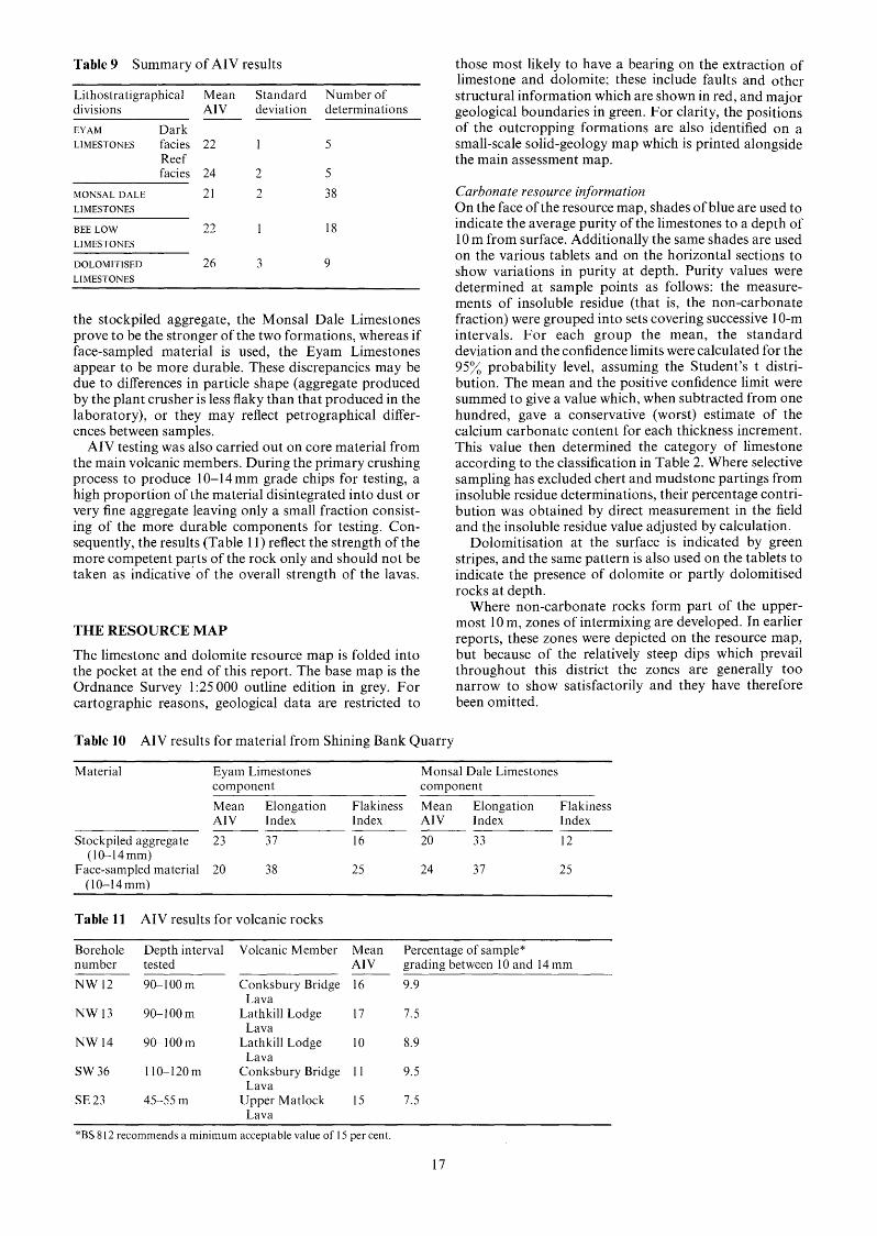
Table 9 Summary of AIV results
Lithostratigraphical Mean Standard Number of divisions AIV deviation determinations EYAM Dark LIMESTONES facies 22 1 5
Reef facies 24 2 5
MONSAL DALE 21 2 38 LIMESTONES
BEE LOW LL 33 1 18 LIMESTONES
DOLOMITISED 26 3 9 LIMESTONES
the stockpiled aggregate, the Monsal Dale Limestones prove to be the stronger of the two formations, whereas if face-sampled material is used, the Eyam Limestones appear to be more durable. These discrepancies may be due to differences in particle shape (aggregate produced by the plant crusher is less flaky than that produced in the laboratory), or they may reflect petrographical differ- ences between samples.
AIV testing was also carried out on core material from the main volcanic members. During the primary crushing process to produce 10-14 mm grade chips for testing, a high proportion of the material disintegrated into dust or very fine aggregate leaving only a small fraction consist- ing of the more durable components for testing. Con- sequently, the results (Table 11) reflect the strength of the more competent parts of the rock only and should not be taken as indicative of the overall strength of the lavas.
THE RESOURCE MAP
The limestone and dolomite resource map is folded into the pocket at the end of this report. The base map is the Ordnance Survey 1 :25 000 outline edition in grey. For cartographic reasons, geological data are restricted to
those most likely to have a bearing on the extraction of limestone and dolomite; these include faults and other structural information which are shown in red, and major geological boundaries in green. For clarity, the positions of the outcropping formations are also identified on a small-scale solid-geology map which is printed alongside the main assessment map.
Carbonate resource informatiof2 On the face of the resource map, shades of blue are used to indicate the average purity of the limestones to a depth of 10 m from surface. Additionally the same shades are used on the various tablets and on the horizontal sections to show variations in purity at depth. Purity values were determined at sample points as follows: the measure- ments of insoluble residue (that is, the non-carbonate fraction) were grouped into sets covering successive 10-m intervals. For each group the mean, the standard deviation and the confidence limits were calculated for the 95% probability level, assuming the Student's t distri- bution. The mean and the positive confidence limit were summed to give a value which, when subtracted from one hundred, gave a conservative (worst) estimate of the calcium carbonate content for each thickness increment. This value then determined the category of limestone according to the classification in Table 2. Where selective sampling has excluded chert and mudstone partings from insoluble residue determinations, their percentage contri- bution was obtained by direct measurement in the field and the insoluble residue value adjusted by calculation.
Dolomitisation at the surface is indicated by green stripes, and the same pattern is also used on the tablets to indicate the presence of dolomite or partly dolomitised rocks at depth.
Where non-carbonate rocks form part of the upper- most 10 m, zones of intermixing are developed. In earlier reports, these zones were depicted on the resource map, but because of the relatively steep dips which prevail throughout this district the zones are generally too narrow to show satisfactorily and they have therefore been omitted.
Table 10 AIV results for material from Shining Bank Quarry
Material Eyam Limestones Monsal Dale Limestones component component Mean Elongation Flakiness Mean Elongation Flakiness AIV Index Index AIV Index Index
Stockpiled aggregate 23 37 16 20 33 12
Face-sampled material 20 38 25 24 37 25 (10-14mm)
(10-14mm)
Table 11 AIV results for volcanic rocks
Borehole Depth interval Volcanic Member Mean Percentage of sample" number tested AIV grading between 10 and 14 mm NW 12 90-100m Conksbury Bridge 16 9.9
NW 13 90-100m Lathkill Lodge 17 7.5
NW 14 90-100m Lathkill Lodge 10 8.9
SW 36 110-120m Conksbury Bridge 1 1 9.5
SE 23 45-55 m Upper Matlock 15 7.5
Lava
Lava
Lava
Lava
Lava *BS 8 12 recommends a minimum acceptable value of I5 per cent.
17

Structural and rnineralisation data This information is largely abstracted from the 1 : 10 560- scale geological maps based on surveys by the Land Survey staff of the Institute. The structural interpretation has been augmented by information obtained from the assessment boreholes.
Dr$t geology Locally the limestone is covered by boulder clay, head or alluvium. Areas where these are thicker than 1.5 m are indicated by black ornament, with the appropriate symbol. These deposits are ignored when calculating limestone quality.
I M A U site data At the site of each borehole or extensive natural section, the purity and other properties of the limestone are indicated in a tablet. The right half of the tablet shows the insoluble residue value for each metre of strata up to a maximum of 15%. Where natural sections are recorded, the elevation above Ordnance Datum is given for the highest stratigraphical horizon collected.
Horizontal sections Horizontal sections have been drawn to show the relationships of the various limestone categories. These sections are constructed from borehole information, the
27 28 29
............... ............... :: Base of mudstone cover '' ................. .................
Basaltic lava at outcrop
65
Mineral thickness above lava e 30m (e lOOft)
Mineral thickness above lava c.30m (looft) 68
I I Mineral thickness > 30m (> looft)
67
----- +Ic i2 Water table ( m above 0.0.)
83 183m (600ft) topographic ___------ contour 6€
Built-up area
65 Rivers
Resource block boundary
letters A and B ) 64 ........... (blocks designated by
62
Figure 11 Variation in mineral thickness across the district.
18

structure as determined from field evidence, and the interrelationships of the various categories and stratig- raphy. They are therefore an interpretation using all the available data and should be treated only as a guide to the likely distribution of purity at depth. In particular, there is insufficient evidence to permit an illustration of the depth of dolomitisation. Zigzag lines have been used diagrammatically to indicate a change in limestone category related to a facies change; the lines do not indicate the precise boundaries between categories.
SUMMARY OF RESOURCES
By dividing the district into two resource blocks, one on either side of the Stanton Syncline, resources with broadly similar characteristics are grouped together and their description is simplified.
B L O C K A This block covers an area of 16 km2 and extends from the northern extremity of the crop to just south of Bradford Dale. The formations at outcrop are the Eyam and Monsal Dale limestones which together comprise a potentially workable thickness of mineral of about 60 m. Both formations are currently worked for aggregate at Shining Bank Quarry [228 6501. The base of the resource for open-pit exploitation is set at the first major volcanic member which over most of the area is the Conksbury Bridge Lava. The variations in mineral thickness above this member are shown in Figure 11. It is apparent from the diagram that the areas where the mineral is sufficiently thick to accommodate a working face 30m high are limited; the largest tract of potentially workable ground lies on the downfaulted block to the south of Long Rake, and there are less extensive zones along the western margin of the crop and in the vicinity of Nether Haddon.
Edmunds (1971) has published tentative watertable contours for the Carboniferous Limestone crop based on data from mine-shafts, cave systems and sough levels and these are reproduced in Figure 1 1. Edmunds stresses that the contours must be regarded as approximate as data on seasonal fluctuations are lacking. Over most of the district the watertable is thought to lie at approximately 152 m (500 ft) which sets the lower limit for dry quarry operations. The 183 m (600 ft) topographic contour is included on Figure 11 to show areas which might be at risk from flooding if operations were instituted below this height.
MineraZ The block contains very limited resources of high purity chemical grade limestone, either at surface or sufficiently close to the surface to be worked by open-pit methods. Reef-knolls within the Eyam Limestones offer the best targets but they tend to be deeply buried or too small to be worth exploiting; thicknesses of the more accessible knolls range from 5 m in Lathkill Dale to 15 m at Nutseats Quarry. High purity mineral is also exposed below the Conksbury Bridge Lava; near Over Haddon the section is some 25 m thick but as the beds are traced up Lathkill Dale the band thins to approximately 10m. Because of this rapid attenuation westwards, the band is not delineated on the adjacent resource assessment map (SK 16). To the east the band occupies a position between the Conksbury Bridge and Lathkill Lodge lavas and has no economic potential.
Over the remainder of the block, the rocks are classified as impure or low grade and these categories are maintained at depth except where subsurface knolls are encountered.
The most impure grades occur north of the Magshaw Anticline within the darker lithofacies of the Monsal Dale and Eyam limestones. The mineral in this area is dark coloured, thinly bedded and cherty, and contains waste partings of shale and mudstone. Over the central and southern parts of the block, the Monsal Dale Limestones are paler, more massively bedded and contain thin chert- free bands of better quality stone (see, for example, NW 5s).
Dips throughout the block range between 10' and 20° and are related to three main fold structures, namely the Stanton Syncline and the Magshaw and Bakewell anticlines.
Mineralisation is largely restricted to the Alport-by- Youlgreave mining field, located on the south side of Long Rake, and some contamination of the resources by ore or gangue minerals must be anticipated immediately adjacent to the veins which form this field.
Overburden The limestone crop is largely free from overburden except for patches of boulder clay to the north of Alport and in the Bakewell area. The deposit is locally quite thick (9m at Shining Bank Quarry) and its removal could pose a problem. Elsewhere the drift cover is restricted to thin patches of head and alluvium along the major valleys. Namurian mudstones also occur as overburden to the limestones in outliers near Alport and west of Bakewell.
B L O C K B The southern limb of the Stanton Syncline comprises an assemblage of carbonates interbedded with substantial thicknesses of volcanic rock which constitute waste. The principal volcanic members are the Upper and Lower Matlock lavas which have maximum thicknesses of 35 m and 36 m, respectively. The Upper Matlock Lava dies out west of Wensley but its horizon is marked by a persistent band of dark limestone and clay wayboard. Similarly the Lower Matlock Lava is absent west of Gratton Moor.
The lavas are important hydrogeologically since they can give rise to temporary perched watertables; this effect is illustrated in Gratton Dale where springs emerge from the limestone-lava junction. However, over most of the block, the regional watertable is generally well below the ground surface and is unlikely to be intersected in quarrying operations, except on the low ground in the extreme north-west of the block and in the Derwent valley, near Matlock (see Figure 11).
Down-dip from the lava outcrops resources are negligible in a zone which varies in width between 100 and 600 m where the mineral is probably too thin to support a working face. The zone is widest on the escarpment south of Wensley where the ground surface dips at approxi- mately the same angle as the underlying strata.
Mineral The limestones in the central and western parts of the block are extensively dolomitised. The dolomit- isation is irregular, particularly towards the margins of the affected area and individual beds or lenses of unaltered limestone lie within the mapped limits of the dolomite crop. The dolomitisation cuts across the boundaries of the limestone formations but is confined locally by impermeable wayboards and lavas. The depth of alteration varies and is unpredictable because of the controls exerted by joint and fracture systems in channelling the magnesium-bearing solutions. The depth of dolomitisation on Gratton Moor has been proved to 55 m in borehole SW 19. Elsewhere, dolomitisation was
19

found to penetrate 34.5 m (SE 23) and 16.0 m (SW 18) below surface. The purest dolomites are found in the Monsal Dale Limestones in the west of the block. Analyses of material from this district and from adjacent areas compare favourably with published analyses (Industrial Minerals, 1976) of dolomites used as fluxes, clay conditioners and as a refractory material in the iron and steel industry. However, a more detailed in- vestigation would be required to establish whether or not the deposits have any commercial value.
The mechanical strength of the dolomitised rocks, measured using the AIV test, is appreciably less than that of the limestones in the district.
Limestones unaffected by dolomitisation are restricted to the escarpment between Wensley and Matlock and to the ground around Gratton Moor. In the former area, the mineral has a maximum thickness of about 50 m and is composed of beds lying between the top of the Eyam Limestones and the Upper Matlock Lava. The mineral is predominantly of low purity but medium and high purity beds are developed locally within the upper part of the Monsal Dale Limestones. The limestones are currently quarried at Hall Dale (SE 1s) and have been worked in the past at Cawdor Quarry, near Matlock (SE 2s).
The sequence in the Gratton Moor area is thicker due to the absence of the Upper Matlock Lava. On the north- east-facing slopes of the moor, the Eyam Limestones and the upper beds of the Monsal Dale Limestones contain chert and are of low purity. High purity mineral, representing the interlava sequence, is present on top of the moor but its maximum thickness of about 60 m is only likely to be realised close to the junction with the overlying low-grade limestones. The recognition of high purity mineral in this area is based on borehole infor- mation which was unavailable at the time when the report on the adjacent Monyash district (Cox and Bridge, 1977) was compiled; consequently the band does not appear on the resource map (SK 16) accompanying that report.
Lead ore has been worked extensively in the past, and over much of the block the ground bears evidence of mineral workings. Enhanced trace-metal concentrations must, therefore, be anticipated throughout the area.
Regional dips throughout the block range up to 20' with the majority of beds inclined towards the axis of the Stanton Syncline. In the Wensley-Darley Bridge area, north-south-trending flexures locally complicate the regional pattern.
Overburden The resources are generally free of over- burden apart from small patches of head in the bottom of some of the dry valleys. A narrow deposit of alluvium forms the flood plain of the River Derwent at Matlock and also floors Rowlow Brook. Along the northern margin of the block the resources are concealed by the mudstone cover.
Limestone inliers and subsurface resources within the Stanton Syncline The resources concealed within the Stanton Syncline have not been sampled but the grades which might be anticipated are shown on the horizontal sections beneath the resource map. The limestones are generally too deeply buried to be exploited in open-pit workings, and in the inliers where they crop out, the high level of the watertable would pose an additional problem.
20

APPENDIX A
CLASSIFICATION AND GLOSSARY
CLASSIFICATION The petrographic classification of limestones proposed by Folk (1959) is widely accepted and is used in this report. The classification is summarised in Table 12.
allochem grains and matrix. The former are discrete bodies which have been subjected to some degree of transportation: they include fossils and fossil fragments, oolites, intraclasts and pellets. The matrix is subdivided on grain size into: micro- crystalline ooze (less than 4 micrometres (formerly microns)) termed micrite, a slightly coarser crystalline fabric (4 to 16 micrometres) termed microspar and crystalline calcite cement or spar (greater than 16 micrometres).
size of the allochems into calcirudites (greater than 1 mm), calcarenites (1 to 0.062 mm) and calcilutites (less than 0.062 mm). A grain size term may be incorporated into the main rock as a suffix, for example, biosparrudite. Where the limestones contain significant amounts of other allochems, these may be specified, for example, crinoidal biosparite.
MgO and 30.4% CaO (or 54.3% CaCO,). Rocks containing dolomite are classified as follows:
Clastic limestones consist of two basic components, namely
Limestones are also classified by reference to the mean grain
The pure mineral dolomite (CaMg(CO,),) contains 2 1.9%
10 to 50% dolomite mineral Dolomitic limestone 50 to 90% dolomite mineral Calcitic dolomite more than 90% dolomite mineral Dolomite
In the first category, the use of Folk's terminology is not precluded, for example, dolomitic biosparite.
GLOSSARY Allochem A collective term for one of several varieties of discrete and organised carbonate aggregates, such as fossil fragments, oolites and pellets that serve as the coarser framework grains in most mechanically deposited limestones. Anticline An arch fold, the core of which contains the stratigraphically older rocks. Argillaceous rocks Detrital sedimentary rocks which contain clay or silt-grade material. Bioclasts Broken fragments of organic skeletal material.
Calcarenite A limestone consisting predominantly (more than 50%) of detrital calcite particles of sand size (0.062 to 1 mm). Calcilutite A limestone consisting predominantly (more than 50%) of detrital particles of clay size. Calcirudite A limestone consisting predominantly (more than 50%) of detrital calcite particles larger than sand size (greater than 1 mm). Calcisiltite A limestone consisting predominantly (more than 50%) of detrital calcite particles of silt size. Euhedral A term applied to grains displaying fully developed crystal form. Facies The sum of all the primary lithological and palaeontologicalcharacteristics exhibited by a sedimentary rock, and from which its origin and environment of formation may be inferred. Gangue A mineral in a vein other than an ore mineral. Hydrothermal Pertaining to heated water, to the action of heated water or to the products of the action of heated water. Inlier A limited area of older rocks completely surrounded by younger rocks. Intraclast Material created by penecontemporaneous erosion within a basin of deposition. Lithofacies A mappable subdivision of a stratigraphic unit of any kind distinguished from other adjacent subdivisions on the basis of noteworthy lithological characters. Pericline A general term for a fold in which the dip of the bed has a central orientation; beds dipping away from a centre form a dome, and beds dipping towards a centre form a basin. Rake A body of ore and gangue minerals disposed vertically between two walls of rock; the main type of mineral vein in the Peak District. Sough An adit or tunnel driven specifically to drain a mine. Stylolite An irregular suture-like boundary developed in some limestones. Syncline A trough fold, the core of which contains stratigraphically yomger rocks. Unconformable Describes strata that are separated from underlying rocks by a surface that represents a significant break in sedimentation. Vug A cavity in a rock. Wayboard An old mining term used commonly in Derbyshire to describe a discrete and deleterious thin rock bed, usually of clay.
Table 12
T LIMESTONES
>lo% Allochems ~ 1 0 % Allochems Allochemical Rocks Microcrystalline Rocks
Sparry calcite cement>
microcrystalline ooze
lntrasparite
Oosparite
Biosparite
Biopelsparite
Pelsparite
Microcrystalline I ooze> I 1-10% allochems sparry
calcite cement I I
Intraclasts: lntraclastic
micrite lntramicrite
Fossils: Biomicrite Fossiliferous
Micrite
Biopelmicrite 1 $ 1 Pellets:
Pelmicrite I I Micrite
Classification of limestones (based on Folk, 1959)
1 YO allochems
Micrite
21

APPENDIX B
The following list is arranged in the same order as data on the borehole records. The numbered paragraphs below also correspond with the annotations on the first record (Appendix
I The Registration Number This consists of two statements:
C).
1 The number of the 1:25 000 sheet on which the borehole lies, for example SK 26. 2 The quarter of the 1 :25 000 sheet on which the borehole lies and its number in a series for that quarter, for example NW 9. Thus the full Registration Number is SK 26 NW 9. This is abbreviated to NW 9 in the text. Collected sections are registered in a similar manner using a separate series of numbers, suffixed by the letter S, for example, SK 26 N W 1 s. This is abbreviated to N W 1 s in the text.
2 The National Grid reference All National Grid references on this publication lie within the 100-km square SK unless otherwise stated. Grid references for borehole sites and section limits are given to eight figures (that is, accurate to within 10 m). In the text, six-figure grid references are used for more approximate locations. 3 Location Borehole and section locations are referred to the nearest named locality on the 1 :25 000 base map. 4 Surface level The surface level at the borehole site is given in metres and feet above Ordnance Datum. For collected sections surface level is taken to be the top of the sampled sequence. 5 Type of drill and date of drilling The drilling machines which have been used in this survey are listed below: Flushing agent Type ojrig Water Edeco Stratadrill 36
Dando 250 Air Reich JO 82 The type of machine, diameter of core produced and the month and year of the completion of the borehole are given.
Descriptive borehole log 6 The limestone formational names are listed. 7 Each major rock type is subdivided, where possible, using the rock classification and nomenclature explained in Appendix A, and followed by a brief description. 8 Depth The figures given relate to depths to the base of the lithologies described in the log.
Graphical borehole log 9 Major rock types are represented on a graphical log and diagnostic lithologies are shown using an ornamental overprint. A complete list of symbols is given in Figure 12.
10 Energy (sorting) index (Plumley and others, 1962) In the column representing energy (sorting) index the shaded intervals highlight carbonate lithologies which exhibit textural and compositional properties characteristic of moderate to strongly agitated water conditions at the time of deposition.
1 1 Colour The percentage reflectance of red light (peak wavelength of 660 nm) from the flat, acid-etched rock surface (solid line) and from powder pellet samples (broken line) are shown graphically. A white magnesium carbonate standard with a reflectance value of 100 per cent was used to calibrate the spectrophotometer.
Mechanical properties 12 For most boreholes and sections, the fracture spacing index (If) is measured in millimetres and plotted on a logarithmic scale. 13 For certain boreholes the point-load strength index (Is) is measured in mega newtons per square metre (MN/m2) and is plotted on a logarithmic scale. 14 For most boreholes, the aggregate impact value (AIV) is determined for 10-m aggregated samples, and plotted on a linear scale.
Insoluble residue data 15 Residue values are expressed as weight percentages.
ClassiJi'cation into categories by carbonate content 16 The overall purity of a limestone, averaged over consecutive 10-m intervals of depth, is stated using the following system (see also Table 2). Category Composition (XCaCO,) 1 Very high purity 398.5 2 High purity 397.0 to <98.5 3 Medium purity 393.5 to <97.0 4 Low purity 385.0 to <93.5 5 Impure < 85.0
22

Superficial deposits Allochemical symbols
\-\-- \ ’, 0 Spines
Made ground
Drift, undifferentiated v v
v v Bryozoa
......... ......... ......... ......... Pellets ......... Carbonate sediments
Limestone ( ~ 1 0 % allochems 0 lntraclasts
Gastropods
Dolomite
Corals: solitary
colonial
Dolomitic limestone / Calcitic dolomite
Y Y Brachiopods and undifferentiated bivalve shells Crinoid and undifferentiated echinoderm debris
v u u u
u u
0 0 0 0
A A A Algae ( mainly Dasyc/adaceae Non-carbonate sediments
Shale and mudstone
Varicoloured mudstone, clay (wayboard)
Algae (encrusting forms including Girvane//a
o c a a m
e e Q e Foraminifera ( Saccamminopsis:
s-s-s 1
Extrusive igneous rocks
++++++ ++++++ Additional lithological data
. . . . . . . . . . . . . . .............. .............. Dark coloured limestone : reflectance ... . . . . . . . . . . . . . . . . . . . . . . . . . . . . . . . . . . . . . . . . . . . . . . . . . . . . . . . . . . . . . . . . . . . .............. .............. .............. .............. .............. 15% of red light ( 660 nm
Tuff
. . . . . . . . . ............. I -.’:..;::::::: - 1 . . . . . . . . . . . . . . . . . . . . . . . . . . ....
0 .
Mottled limestone
Chert : nodular
bedded lithological junction
Laminated beds
X gap in data
Graded beds
Vuggy limestone
Veining : Ca - calcite
I 1Ca F2 I Ca F2 - fluorite
Si silicified bioclasts Fe S2 pyrite
Qtz euhedral quartz crystals Mn O2 pyrolusite
Fe iron oxide Figure 12 Explanation of symbols used on graphical logs.
clay disseminated clay minerals
23

APPENDIX C
RECORDS OF BOREHOLES AND SECTIONS
69 0 NW 12 NW 2s
0
I 0 IMAU boreholes
G o t her boreholes
0 Collected sect ions
68 < NW NW 35
67 L BLOCK A \
O N W 7s -
NW8S @ 65 OSW6S
e s w 7s
sw?-
o s w 5 s
64/
0 NW 5s
63
61
RESOURCE BLOCK A RESOURCE BLOCK B
Source ofdata Registration number
IMAU boreholes (drilled NW9 by contractor) NW 12
NW 13 NW 14
Commercial borehole SW 36 Major sections used in the assessment
NW 1s NW2s NW3s NW4s NW5s NW6s NW7s NW8s SW Is sw 2s sw 3s sw 4s SW 5s SW 6s SW7s
Grid Source of data reference
2074 6826 IMAU borehole (drilled 2077 6897 by contractor) ;iz; z!:: Commercial boreholes
2325 6458 21 33 6945 2 136 6894 21 1 1 68 19 Major sections used 2382 6577 in the assessment 2283 6505 2034 6608 21 34 6556 2093 6498 2341 6397 2287 6460 21646416 23 18 6473 201 5 638 1 2 169 6494 2 1 97 6479
Registration number
SE 23
SW 18 SW 19 sw 20 SW 23 SW 37
SE Is SE 2s SE 3s SE 4s
Grid rejerence
2571 6095
2035 6034 2027 6025 2045 6G48 2003 6 155 2444 6 154 2889 5986 2865 6064 2677 6033 2701 6060
24

LITHOLOGY COLOUR MECHANICAL PROPERTIES
FRACTURE INDEX STRENGTH INDEX SORTING (If.mm). (Is MN/M)
M I 0 50 10010 50 100 5001Ooo
SK 26 NW 9l 2074 68262 Stonedge Lane3 Surface level + 193.2 m (+ 634 ft)" Reich (airflush) 74 mm diameter5
0.5 1.0 5.0 -
Block A
Thickness
Topsoil
Monsal Dale Limestones6 Biomi~rosparite,~ medium to coarse calcarenite; some thin-shelled, partly silicified brachiopods
Crinoidal biosparite, moderate to well- sorted
Biomicrosparite, sporadic chert nodules Biomicrosparrudite,with abundant
brachiopods-some partly silicified, sporadic chert nodules
Biomicrite, grey to 5.23 m, continuing dark grey to base, sporadic nodular and tabular cherts from 4.42 m to 4.60 m and from 6.96 to 7.06 m
Biomicrosparite
Biomicrite, grey to dark grey, medium calcarenite; abundant clay in matrix
Tuffaceous clay, brown and yellow Conksbury Bridge Lava Basalt, amygdaloidal; contained blocks
of pyritised calcilutite Borehole completed at 34.65 m The annotations are explained in Appendix B
Gap
m 0.40
1.09
0.05 0.8 1
1.65
3.06 0.64
22.65
1.05 0.18
3.07
Depths m 0.40
1.49
1.54 2.35
4.00
7.06 7.70
30.35
3 1.40 3 1.58
34.65
A.I.V. - 20 30 40
INSOLUBLE
DATA RESIDUE PURITY
5 10 15 - L
7
A NW9
10
20
30
25

LITHOLOGY COLOUR
SORTING
.............. .............. ......... ........ . . . . . . . . .
..... 1.;- ............... .............. si , s i , 1 .............. ............... .............. . . .~ ................ . . . . . . . . . . . . . . ........ ........ ........ . . . . . . . .FeS2 1::
30 .............................. .............. ............... .............. ............... ....... : : : : : :&.:.I.:.:.:. ............... .............. ............... .............. ............... .............. ............... ..............
...................... ........... m:.:]
.-'..R'R.-.-.
I . . ........................... . . . . . . . . . . . . . ........ : : ... : : :.&%*:::::
u v ' ........
+++++++ +++++++ +++++++ +++++++ +++++++ +++++++ +++++++ +++++++ +++++++ +++++++ +++++++ +++++++ +++++++ .... .\:.".:.:.i:v.>'. +++++++ +++++++ +++++++ +++++++ +++++++ +++++++ +++++++ +++++++ +++++++ +++++++ +++++++
* o - + + + + + + +
+++++++ go-+++++++
. . . . . . . .
I I I I
MECHANICAL PROPERTIES
FRACTURE INDEX (If.mm).
1 50 100 500100( - A.I.V.
1 20 30 40 -
1
RESIDUE DATA INSOLUBLE
5 10 15
36.4 18.6 23.8 41.7
L------ 56.5
-5Ei 27.0 16.4
21.1 28.0 17.6 15.0 15.1 - 17.4
L 18.3 19.6 e 22.3
44.8 31.6
22.0 18.1 22.3
22.1 17.6 21 .o 30.1 24.7
27.7 _c;
e 42.0
A - 0 NW 12
10
40
70
80
100
26
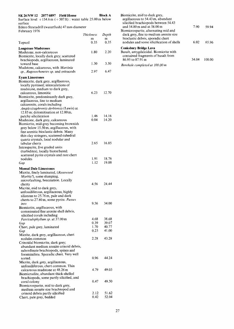
SK 26 NW 12 2077 6897 Field House Block A Surface level + 154.6 m (+ 507 ft) : water table 25.00 m below surface Edeco Stratadrill (waterflush) 47 mm diameter February 1976
Thickness Depth
Topsoil 0.35 0.35 Longstone Mudstones Mudstone, non-calcareous 1.80 2.20 Biomicrite, locally dark grey; scattered
brachiopods, argillaceous, laminated toward base 1.30 3.50
sp., Rugosochonetes sp. and ostracods 2.97 6.47
m m
Mudstone, calcareous, with Murtiniu
Eyam Limestones Biomicrite, dark grey, argillaceous,
locally pyritised; intercalations of mudstone, medium to dark grey, calcareous, limonitic
argillaceous, fine to medium calcarenite, corals including Amplexizuphrentis derbiensis (Lewis) at 12.85 m; dolomitisation at 12.80 m, patchy silicification
Biomicrite, predominantly dark grey,
Mudstone, dark grey, calcareous Biomicrite, mid-grey becoming brownish
grey below 15.50 m, argillaceous, with fine arenitic bioclastic debris. Many thin clay stringers, scattered euhedral quartz crystals, local nodular and tabular cherts
(turbidites), locally bioturbated; scattered pyrite crystals and rare chert nodules
Intrasparite, five graded units
Gap Monsal Dale Limestones Micrite, finely laminated, (Rosewood Marble?), some slumping, microfaulting, brecciation. Locally cherty
unfossiliferous, argillaceous, highly siliceous to 25.76 m, pale and dark cherts to 27.80 m, some pyrite. Pusses into
Biomicrite, argillaceous, with comminuted fine arenite shell debris, silicified corals including Fusciculophyllum sp. at 37.00 m
Micrite, mid to dark grey,
Gap Chert, pale grey, laminated Gap Micrite, dark grey, argillaceous, chert
Crinoidal biomicrite, dark grey; nodules common
abundant medium arenite crinoid debris, subordinate brachiopods, spines and foraminifera. Sporadic chert. Very well sorted.
unfossiliferous, chert common. Thin calcareous mudstone at 48.26 m
Biomicrudite, abundant thick-shelled brachiopods, some partly silicified, and coral colony
medium arenite size brachiopod and crinoid debris partly silicified
Micrite, dark grey, argillaceous,
Biomicrosparite, mid to dark grey,
Chert, pale grey, bedded
6.23 12.70
1.46 14.16 0.04 14.20
2.65 16.85
1.91 18.76 1.12 19.88
4.56 24.44
9.56 34.00
4.68 38.68 0.39 39.07 1.70 40.77 0.23 41.00
2.28 43.28
0.96 44.24
4.79 49.03
0.47 49.50
2.12 51.62 0.42 52.04
Biomicrite, mid to dark grey, argillaceous to 54.43 m, abundant silicified brachiopods between 54.43 and 54.80 m and at 58.00 m 7.90 59.94
Biomicrosparite, alternating mid and dark grey, fine to medium arenite size bioclastic debris, sporadic chert nodules and some silicification of shells 6.02 65.96
Conksbury Bridge Lava Basalt, amygdaloidal. Biomicrite with contained fragments of basalt from 86.95 to 87.91 m
Borehole completed at 100.00 m 34.04 100.00
27

LITHOLOGY COLOUR
SORTING M I om . . . . . . . . . . . . . . . . . . . . . . . . . . . . . .
U .:..: '_'_ :: .::: ' . . . . . . . . . . . . . . .
+++++++ +++++++ +++++++ t++++++ +++++++ +++++++ +++++++ +++++++ t++++++ t++++++ t++++++ t++++++ t++++++ t++++++ t++++++ t++++++ t++++++
t++++++ t++++++ t++++++ t++++++ - \ o \ -1 0 I \w
60-t++++++
70-t++++++
J : ; ! ! ; ! A A A A A A A A
u u u u u
80 - 0 .'.'. U
FeS2 v O:.:.:
v :.:.. " 0
v :.:.:
, , -2-++++++ . w . u 4 u*u.:.
t++++++ t + + + + + + +++++++ t + + + + + + t + + + + + + t + + + + + + t + + + + + + t + + + + + + t + + + + + +
t + + + + + + t + + + + + + +++++++
100-t++++++
Li +++++ +++++ +++++ ++++t +++++ +++++
110 +++++
MECHANICAL PROPERTIES
FRACTURE INDEX STRENGTH INDEX A.I .V. (Is M N / M )
D 50 100 5001001 (If.mm). - I I
r
20
/ ---l
I
30 40 - 0
INSOLUBLE RESIDUE DATA
5 10 15 111
i_ 28.1
25.3
< 24.6 c 28.8 25.7
40.0 <
r \
A . O NW 13
,lo
20
30
40
50
60
70
80
90
100
110
28

S K 26 NW 13 2142 6587 Conksbury Bridge Block A Surface level + 196.2 m ( + 644 ft) Edeco Stratadrill (waterflush) 47 mm diameter February 1976
Pleistocene and Recent Bould.er clay, red and brown with limestone, chert and sandstone fragments
Eyam Limestones Biomicrite, dark grey Biomicrosparite; sporadic shell debris.
Biosparite, rare bryozoa Biomicrite, dark grey, moderate sorting Biosparite, medium calcarenite, containing moderately sorted crinoid and brachiopod debris. Passes into
Biomicrosparite, pale and mottled grey; orientated brachiopods, sporadic chert beloy 4.00 m
Biomicrite, argillaceous below 5.00 m, large bryozoa at 4.80 m
Biomicrosparite, dark grey, argillaceous below 7.00 m; tabular cherts between 6.70 and 6.75 m, rock totally silicified from 7.61 to 7.75 m
Passes into
Gap Dolomitic micrite, dark grey,
unfossiliferous, with abundant disseminated dolomite rhombs
Biomicrosparite
Eyam Limestones (reef facies) Biomicrite, medium oalcarenite; crinoid
and bryozoan debris in partly silicified matrix; brachiopods and foraminifera increase below 13.30 m
Monsal Dale Limestones Biomicrosparite, mottled between 17.65
and 19.33m and between 21.35 and 2 1.60 m; alternations of fine and coarse bioclastic shell debris to 17.65 m, corals including Lithostrotion junceum (Fleming) between 21.65 and 21.80 m, sporadic chert nodules
Coral band containing Diphyphyllum lateseptatum (McCoy), Lithostrotion junceum, Lithostrotion portlocki (Brown) and Orionastraea sp.
grade bioclastic debris
mottled, chert nodules common, bituminous from 27.41 to 27.61 m
Biomicrudite, buff-grey; abundant silicified brachiopods, sporadic chert nodules
common, patchy silicification throughout, quartz crystals common below 37.16 m. Oil-filled calcite veins from 35.10 to 35.23 m
Biomicrite, pale buff, much fine arenite
Biomicrosparite, pale buff, sporadically
Biomierosparite; clay-filled stylolites
Biosparite, pale buff, locally pelletal Biomicrudite; abundant thick-shelled brachiopods, argillaceous and limonitic matrix
Clay, blue-grey Brachiopod biomicrudite Clay, blue-grey, pyritous. Weathered
Tuff, grey, pyritous; common patches of amygdaloidal basalt
silica
Thickness m
1.20
0.25
0.15 0.39 0.1 1
1 .oo
1.25
1.95
2.06 0.54
0.21 0.76
5.09
6.94
0.97
1.66
7.99
0.68
4.62 2.78
1.30 0.06 0.82
0.47
0.62
Depth m
1.20
1.45
1.60 1.99 2.10
3.10
4.35
6.30
8.36 8.90
9.1 1 9.87
14.96
21.90
22.87
24.53
32.52
33.20
37.82 40.60
41.90 41.96 42.78
43.25
43.87
Conksbury Bridge Lava Basalt, amygdaloidal, sporadic pyrite, rare autobrecciation
Tuff Monsal Dale Limestones Biomicrosparite, patchy mottling, local
abundant brachiopods-some partly silicified at 77.80 m
Brachiopod biosparrudite; most shells silicified
Biosparite, patchily mottled; Lithostrotion junceum at 83.50 m and Palaeosmilia regia (Phillips) at 87.37 m. Pyrite common. Base marked by layer of orientated brachiopods
bioclasts heavily encrusted with algal- coatings
Brachiopod biopelsparite, well-sorted
Coral band, massive Chaetetes colony Lathkill Lodge Lava Basalt, amygdaloidal, partly scoriaceous Borehole completed at 110.35 m
31.58 0.45
2.22
0.36
7.77
0.59 0.09
2 1.42
75.45 75.90
78.12
78.48
88.25
88.84 88.93
110.35
29

M 0
10
20
30
40
50
60
70
80
90
1OC
LITHOLOGY COLOUR MECHANICAL PROPERTIES
SORTING 1
4 4 0 w
e o A "
4
w F e S 2 ~ Y
o w m
4 m
m Si
* - - .:: u'
"
0 . . . -
FZS~ d s i - e + + + + + . + + + + + + I - + + + + + . + + + + + + . e + + + + + e + + + + + . t + + + + + . I + + + + + . e + + + + + . I + + + + + . I - + + + + + . I + + + + + I + + + + + . I - + + + + + I + + + + + . + + + + + + - I + + + + + . + + + + + + + + + + + + . I + + + + + . I + + + + + . I + + + + + ' I + + + + + - + + + + + + . I + + + + + . + + + + + + . e + + + + + . I - + + + + + . I + + + + + . + + + + + + - + + + + + + . + + + + + + - e + + + + + . + + + + + + - I + + + + + . e + + + + + - + + + + + + . e + + + + + . I - + + + + + - e + + + + + I + + + + + e + + + + + . e + + + . + + . e + + + + + . I - + + + + + e + + + + + . e + + + + + t + + + + + e + + + + + t + + + + + t + + + + + t + + + + + t + + + + + Il*IIL
FRACTURE INDEX STRENGTH INDEX (Is MN/M) A.I.V. 0.5 1.0 5.0 - 10 20 30 0
RESIDUE DATA INSOLUBLE
5 10 15 -
28.9
19.2
A 0 NW14
IO
20
30
40
50
60
30

S K 26 NW 14 2369 6585 Nutseats Quarry Block A Lathkill Lodge Lava Surface level + 1 13.1 m ( + 37 1 ft) Edeco Stratadrill (waterflush) 47 m diameter January 1976
Made ground Eyam Limestones Crinoidal brachiopod biosparite,
medium to coarse calcarenite, shells partly silicified, foraminifera common below 1.50 m. Well-sorted assemblage
Gap Biomicrite Crinoidal biosparite, coarse calcarenite
to fine calcirudite; solitary coral Dibunophyllum sp. at 4.15 m, sporadic small chert nodules
Eyam Limestones (reef facies) Bryozoan biomicrite, vuggy, with pyrite
and carbonaceous material Bryozoan crinoidal biosparrudite,
solitary coral Koninckopyllum sp. ht 9.85 m
Koninckophyllum sp. and Rotiphyllum costatum (McCoy). Calcite and pyrite veining from 12.88 to 12.97 m
Crinoidal biosparrudite, some bryozoa; mixed spar and micrite matrix. Locally pyritous
Coral band with large specimens of
Monsal Dale Limestones Biomicrite; fine silicified bioclastic
debris. Solitary coral Amplexizaphrentis derbiensis at 2 1.92 m. Influx of coarse arenite crinoid debris between 22.60 and 22.80 m. Passes into
Biomicrosparite, mid-grey, mottled Biosparite, pale grey-buff, fine to
medium calcarenite; algal-encrusted brachiopods throughout, corals at 26.72 m- Diphyphyllum lateseptatum and 27.80 m- Koninckophyllum sp. Small clusters of pyrite crystals at 27.56 m
Coral biomicrosparite; Dibunophyllum sp., DiphJyhyllum lateseptatum and Syringopora sp. Passes into
Biosparite, pale grey-buff, mottled below 30.70 m
Biomicrosparite, mottled; coral (Caninia sp. (cornucopiae Michelin group)) at 33.20 m. Shells silicified below 35.00 m. Chert nodules common below 32.25 m
Biomicrite; chert nodules to 37.40 m. Many clay-filled stylolites
Biomicrosparite, mottled, with corals between 39.65 and 39.85 m- Dibunophyllum bipartitum (McCoy), Diphyphyllum lateseptatum and Lithostrotion pauciradiale (McCoy)
Dibunophyllum bipartitum, Diphyphyllum lateseptatum, Lithostrotion junceum, L. pauciradiale and Nemistium edmondsi (Smith). Much pyrites at base
Conksbury Bridge Lava Basalt, amygdaloidal, much pyrite, some lapilli, local calcite veining
Coral biomicrosparite; large colonies of
Clay, grey
Basalt, dark green, locally amygdaloidal 15.38 100.05 Borehole completed at 100.05 m
Thickness m 0.30
Depth m 0.30
2.16 2.46 0.59 3.05 0.62 3.67
1.28 4.95
3.08 8.03
2.71 10.74
2.23 12.97
6.85 19.82
3.49 2.99
1.51
1.99
1.43
4.77
3.40
3.68
23.31 26.30
27.81
29.80
3 1.23
36.00
39.40
43.08
2.76 45.84
38.81 84.65 0.02 84.67
31
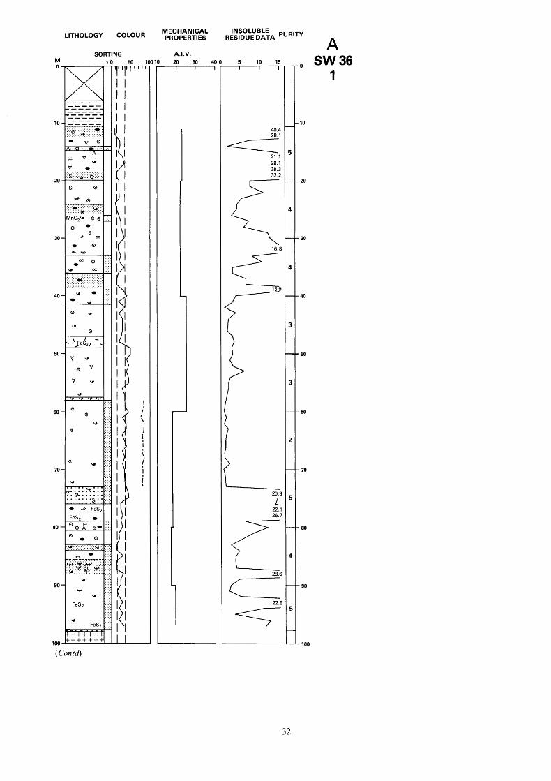
M 0
10
20
30
40,
50,
60
70
80 -
90.
100
LITHOLOGY COLOUR
SORTING
- v 0
OC v u
. .Q .. 0, ....... A
I - :si.:.:.~:.:.p:.:.:.: .-. .. . . . . . . . . . . . .............. . . . . . . . . . . . . SI 0 1 1
0 0
. . . oc 0 I:.::: - . . .
u cc .:.:.; :. . . . . ::r.:.:.:.,.:.:.:.:.
. . . . . . . . . . . . . . . . . . . . . . . . . . . . . . . . . . . . . . . . . . . . . . . . . . . . . . . . . . . . . . . . . . . . . . . . . . . . . . . . . . . . . . . . . . . . . . . . . . . . . . . . . ... ... * .I.:: . . . - . . . . . . ...
0 u
* 0
I , 'JeS2, . I -
0 v
v u
I I
I
! ', I
i I i i
! I
MECHANICAL PROPERTIES
A.I.V. - 20 30 40
RESIDUE DATA INSOLUBLE
5 10 15 - 40.4
2171 20.1 38.3
20.3
L 22.1 26.7
22.9
-==7
A 0 SW36
1
10
,20
30
40
50
60
70
80
90
100
(Contd)
32

SK 26 SW 36 2325 6458 Bowers Hall Surface level c + 137 m ( + 450 ft) 1974
Gap Longstone Mudstones Mudstone, dark grey Eyam Limestones Crinoidal brachiopod biosparite, mid to dark grey, laminated, shells commonly silicified, sporadic chert
Pelsparite; algal-corroded shell debris. Some silicification
Biosparite; abundant dasycladacean algae at top and scattered bryozoa near base, matrix becomes more micritic towards base. Common chert
Biomicrite, dark grey; some silicification Crinoidal biosparite, locally pelletal;
scattered traces of green volcanic(?) detritus. Minor silicification. Oil present in cavities
from 27.15 to 27.92 m and between 32.40 and 33.00 m. Alternating with biosparite, mid-grey, with algal- encrusted, calcarenite-grade bioclasts. Allochems well-sorted below 33.00 m
Crinoidal biomicrite, dark grey, cherty. Passing at 38.65 m into biosparite, pale grey, with well-sorted, fine arenite grade comminuted shell debris
Biomicrite, dark grey, cherty to 26.40 m,
Eyam Limestones (reef facies) Crinoidal biosparite; rudite crinoid debris common to 45.30 m, influx of bryozoa from 48.90 m to base. Diphyphyllum at 57.40 m. Well- developed vugs containing traces of oil between 47.00 and 48.84m. Pyrite present along joints
Monsal Dale Limestones Biosparite; well-sorted bioclasts Crinoidal biopelsparite; algal-corroded shell debris, partly silicified. Corals including Palaeosmilia regia and Koninckophyllum magniJicum (Thomson and Nicholson) at 73.10 m. Sporadic small chert nodules
Biomicrite, cherty and pyritous Crinoidal biosparite; well-sorted
comminuted bioclasts. Traces of green volcanic (?) detritus. Minor silicification, sporadic cherts
Crinoidal biomicrite. Mudstone wisps. Local chert
Biopelsparite, quartz crystals throughout
Biomicrite, dark grey; coral band with Lonsdaleia duplicata (Martin) and Nemistium edmondsi from 85.50 to 87.79 m. Lithology is increasingly argillaceous and pyritous towards base
Tuff, green, pyritous (Con td)
Thickness m 6.00
4.55
3.31
0.74
3.80 1.30
4.00
Block A
Depth m 6.00
10.55
13.86
14.60
18.40 19.70
23.70
12.45 36.15
5.27 41.42
16.58 58.00
14.70 72.70
2.80 3.35
1.74
2.41
1 .oo
13.82 0.20
75.50 78.85
80.59
83.00
84.00
97.82 98.02
33

M
LITHOLOGY COLOUR
loo +++++++ +++++++ +++++++ +++++++ +++++++ +++++++ +++++++ +++++++ +++++++ +++++++ +++++++ +++++++ t++++++ t + + + + + + +++++++ +++++++ t + + + + + + t + + t + + +
'
110-+++++++
120 -iu - - * ---.:.
0 .:: Si
u :.: 0
Si :::
130- y u
0.:::::::;:
MECHANICAL PROPERTIES
A.I.V. - 20 30 40
RESIDUE DATA INSOLUBLE
5 10 15
jr SK 26 SW 36 2325 6458 Bowers Hall Block A
Conksbury Bridge Lava Basalt, amygdaloidal to 107.00 m 21.13 119.15 Monsal Dale Limestones Brachiopod biomicrite, pale grey, locally
Biosparite, pale grey, medium to fine pelletal
calcarenite with well-sorted bioclasts, local silicification
Pelsparite Borehole completed at 131.40 m
0.75 119.90
10.75 130.65 0.75 13 1.40
36
34

LITHOLOGY COLOUR
SORTING M
-- - + S F
\
/ ' ..... ......... . . . . . . . . . . . . . -.-.-._ . . . . . . . . . . . .
I I
20 -
1c T7-r
RESIDUE DATA INSOLUBLE
1,. SK 26 NW 1s 2133 6945 Holmebank Chert Quarry Block A Surface level + 180.8 m ( + 593 ft)
Thickness Depth Monsal Dale Limestones m m Biomicrite, scattered bioclastic debris, variable silicification, some chert nodules 8.00 8.00
Biomicrosparite, medium calcarenite. Brachiopod, crinoid and spine debris patchily silicified. Finely laminated towards base 2.00 10.00
Biomicrite, mid to dark grey, sparsely fossiliferous. Quartz crystals abundant in matrix 1.70 11.70
Section completed ut I I .70 m
LITHOLOGY COLOUR
SORTING
INSOLUBLE RESIDUE DATA
SK 26 NW 2s 2136 6894 Endcliff Wood Surface level + 152.4 m ( + 506 ft)
Monsal Dale Limestones Biomicrosparite, mid to dark grey, fine to medium calcarenite, with abundant brachiopod, crinoid and foraminiferal debris. Locally argillaceous. Shells partly silicified
Gap Biosparite; well-sorted bioclasts showing
selective silicification Biomicrosparite, mid to dark grey, with
abundant brachiopods between 10.80 and 1 1 .OO m. Local patchy silicification
Biosparite; abundant bioclastic debris. Moderate to good sorting. Shells partly silicified
Biomicrosparite, mid to dark grey argillaceous towards base
Section completed ut 18.00 m
Thickness Depth m m
4.00 4.00 2.50 6.50
1.50 8.00
6.00 14.00
2.00 16.00
2.00 18.00
A NW 2s
Block A
A NW IS
35
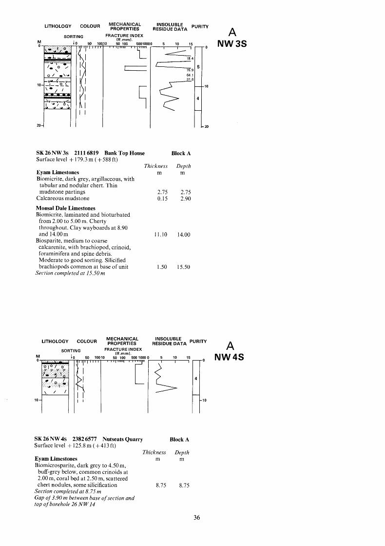
LITHOLOGY COLOUR
SORTING M 1 0 -. [ I I
I I
MECHANICAL INSOLUBLE PURITY PROPERTIES RESIDUE DATA A FRACTURE INDEX
(If.rnrn). D 50 100 50010000 5 10 15
S K 26 NW 3s 2111 6819 Bank Top House Block A Surface level + 179.3 m ( + 588 ft)
Thickness Depth Eyam Limestones m m Biomicrite, dark grey, argillaceous, with
tabular and nodular chert. Thin mudstone partings 2.75 2.75
Calcareous mudstone 0.15 2.90
Monsal Dale Limestones Biomicrite, laminated and bioturbated from 2.00 to 5.00 m. Cherty throughout. Clay wayboards at 8.90 and 14.00 m
calcarenite, with brachiopod, crinoid, foraminifera and spine debris. Moderate to good sorting. Silicified brachiopods common at base of unit
Biosparite, medium to coarse
Section completed at 15.50 m
LITHOLOGY COLOUR
SORTING
lo{-
f. 50 IO(
I 1
'I
MECHANICAL PROPERTIES
FRACTURE INDEX (If.rnrn1.
1 50 100 500 1000 - r I
0
11.10 14.00
1.50 15.50
. O NW 3s
10
20
INSOLUBLE RESIDUE DATA A
I 5 10 15
I
5
SK 26 NW 4s 2382 6577 Nutseats Quarry Block A Surfacelevel +125.8m(+413ft)
Thickness Depth Eyam Limestones m m Biomicrosparite, dark grey to 4.50 m,
buff-grey below, common crinoids at 2.00 m, coral bed at 2.50 m, scattered chert nodules, some silicification
Section completed at 8.75 m Gap o j 3.90 m between base ojsection and top ojborehole 26 N W 14
8.75 8.75
To NW 4s
1
36

LITHOLOGY COLOUR MECHANICAL PROPERTIES
SORTING FRACTURE INDEX (If.rnm). A.I.V. M 4 0 %.:....:+.- ..... . . . . . . . . . . . . . . . .........................
............ .a,: '.:.~.:.:.:.:.,y:.:.:.:.
. . . . . . . . . . . . . . . . . . . . . . --.-.- . . . . . . . . . . . . . . . . . . . . . . . . . . . . . . . . . .o: ............ . . . . . . . . . . . . . . . . . . . . . . . . . . . . . . . . . . . . . . . . . . . . . . . . . . . . . . . . . . . . . . . . . . . . . . . . . . - ---
U
w r30 10 -
U
0
0 U ----
2 0 - " 0
0
0
0 u
30 -
T 50 100 500 1000 1 20 30 40 -
(See report In Physical Properttes sectlon)
SK 26 NW 5s 2283 6505 Shining Bank Quarry Block A Surface level + 13 1.4 m ( + 43 1 ft)
Thickness Depth Eyam Limestones m m Biomicrite, dark grey, scattered chert nodules, some silicification 5.00 5.00
Clay, grey, laminated, iron-stained 0.40 5.40 Monsal Dale Limestones Biomicrosparite; brachiopod and crinoid debris, Lithostrotion vorticale (Parkinson) at 9.00 m, some chert below 18.00 m, argillaceous at base 22.10 27.50
16 m of exposed strata inaccessible) Section completed at 27.50 m (uppermost
RESIDUE DATA INSOLUBLE
A 5 10 15 111
32.2
LITHOLOGY COLOUR INSOLUBLE PROPERTIES RESIDUE DATA
SORTING FRACTURE INDEX (If.mrn1. M 0 0 0
10
I I I I 20 4 I I I
SK 26 NW6s 2034 6608 Lathkill Lodge Surface level + 190.3 m ( + 624 ft)
Monsal Dale Limestones Biomicrite, patchy silicification of bioclastic debris. Sporadic chert nodules
Biopelsparite, well-sorted Biomicrosparite, mostly finely comminuted bioclastic debris
Pelsparite, well-sorted Gap Biosparite, medium calcarenite Gap Biosparite, with abundant pelletal grains
between 13.00 and 14.00 m Section completed at 15.50 m
Thickness m
4.00 1 .oo
2.00 1 .oo 2.00 0.50 1 .oo
4.00
Block A
Depth m
4.00 5.00
7.00 8.00
10.00 10.50 11.50
15.50
10
20
A NW 6s
37

. .-. .^. --., COLOUR MECHANICAL PROPERTIES RESIDUE DATA PUR'TY
INSOLUBLE LI I HULUUY
ING FRACTURE INDEX (If.mm).
;1 r
SK 26 NW 7s 2134 6556 Conksbury Bridge
5 10 15 w
Surface level + 182.9 m ( + 600 ft)
Eyam Limestones Biomicrite, dark grey, common chert nodules, clayey matrix at base
Gap Monsal Dale Limestones Biomicrosparite, bioclastic debris
Biomicrite, pale to mid-grey, clayey
Biomicrosparite, mottled, mostly crinoid
Brachiopod biomicrosparrudite, shells
Biomicrosparite, some clay and chert Crinoidal biosparite; subordinate
Biomicrosparite; thin clay at 24.50 m Section completed at 26.00 m
common
matrix in part
and brachiopod debris
patchily silicified
brachiopod debris
Thickness m
2.00 2 .oo
4.00
5.00
5.00
I .oo 2.00
3.00 2.00
Block A
Depth m
2.00 4.00
8 .OO
13.00
18.00
19.00 21 .oo 24.00 26.00
{ 10
20
A NW 7s
38

COLOUR MECHANICAL INSOLUBLE PROPERTIES RESIDUE DATA
FRACTURE INDEX A SORTING Ilf.mm1. N W 8s M 1
0' ' - 10
20
30 J I
" I I I
!1 I I
I I I
SK 26 NW 8s 2093 6498 Conksbury Lane Surface level + 175.4 m ( + 576 ft)
Monsal Dale Limestones Biomicrosparite, fine to medium arenite
grade brachiopod and crinoid debris, some chert
bioclastic debris Biosparite, pale grey,.abundant
Gap Biosparite, abundant foraminifera,
Biomicrosparite, pale grey, brachiopods
Silica rock-altered wall-rock of Long
matrix largely silicified
common
Rake Gap Biosparite Brachiopod biomicrosparrudite, shells
variably silicified Clay, grey
Biomicrosparite; large colony of Lithostrotion pauciradiale, disseminated clay in matrix
Silica rock-altered wall-rock Clay, blue-grey and brown Section seen to 27.00 m but rocks highly altered below 21.20 m
Thickness m
2.00
3.00 3.00
2.00
2.00
2.00 1 .oo 1 .oo 2.00 0.20
0.80 1.20 1 .oo
Block A
Depth m
2.00
5.00 8.00
10.00
12.00
14.00 15.00 16.00
18.00 18.20
19.00 20.20 21.20
39

LITHOLOGY COLOUR
sc
0 0 0 0 .
0.4 u u 0 = .............. ..............
.............. .............. .............. 0 0
0 0 0
" u u u
0 0 0
0
TI NG
MECHANICAL PROPERTIES
FRACTURE INDEX (If.mm).
50 100 50010OC
INSOLUBLE RESIDUE DATA A
5 10 15
53.5 - A6 i
25.9
c6 58.9
SK 26 SW 1s 2321 6397 Stanton Mill Quarry Block A Surface level + 145.4 m (+ 477 ft)
Thickness Depth Eyam Limestones m m Crinoidal biosparrudite, pale to dark grey, fining towards base; abundant current-sorted crinoid ossicles and brachiopods. Many small chert nodules. Thin mudstone at 8.25 m
Crinoidal biosparite, massive-bedded; shell horizon at 13.00 m, traces of bryozoa, micritic matrix locally, laminated and bioturbated at 15.00 m. Some silicification of bioclasts 6.80 17.60
Section completed at 17.60 m
10.80 10.80
LITHOLOGY COLOUR
rlNG
MECHANICAL PROPERTIES
FRACTURE INDEX (If.mm).
L
SK 26 SW 2s 2287 6460 Alport Flour Mill Surface level + 155.4 m ( + 5 10 ft)
* 0 S W I S
10
20
RESIDUE DATA INSOLUBLE
A
? I
I 5 10 15
Block A
Thickness Depth Eyam Limestones m m Biomicrite, dark grey, thinly-bedded;
nodular and tabular cherts common 6.00 6.00
Monsal Dale Limestones Biomicrosparite, mottled, crinoids and
Section completed at 16.50 m brachiopods common locally 10.50 16.50
1 0 sw2s
40

LITHOLOGY COLOUR INSOLUBLE
PROPERTIES RESIDUE DATA A so
M 0.
10
0
U 0 I
rlNG FRACTURE INDEX (If.rnrn). C I 50 100 v 500 100( P 5 10 15 -
SK 26 SW 3s 2164 6416 Bradford Dale Block A Surface level + 158.7 m (+ 521 ft)
Thickness Depth Eyam Limestones m m Biomicrite, thinly-bedded, flaggy in part, bioclastic debris mainly composed of brachiopods and crinoids with some foraminifera
scattered chert nodules
tabular chert
Biosparite, locally argillaceous with
Biomicrite; abundant nodular and
Section completed at 10.40 m
5.00 5.00
4.00 9.00
1.40 10.40
LITHOLOGY COLOUR
SORTING r I I I I
I I
00 -
SK 26 SW 4s 2318 6473 Harthill Lodge Surface level + 134.4 m ( + 441 ft)
Eyam Limestones Biomicrite, dark grey; clayey matrix.
Shells and matrix partly silicified Biosparite; abundant bioclasts, influx of
brachiopods between 3.00 and 4.00 m. some nodular and tabular chert
towards base, cherty
subordinate crinoid and foraminiferal debris
cherty
Biomicrite, dark grey becoming paler
Brachiopod biomicrosparrudite;
Biomicrosparite, mid to dark grey,
Section completed at 11.25 m
0
.IO
Block A
Thickness Depth m m
1.00 1.00
4.00 5.00
2.00 7.00
1.00 8.00
3.25 11.25
0 sw3s
.IO
A sw 4s
41

LITHOLOGY
SOR' M
3x 40
. . . . . . . . . a
..........
l-If
COLOUR MECHANICAL INSOLUBLE PROPERTIES RESIDUE DATA A
UG FRACTURE INDEX (If.mm).
'3 5 10 15 - L c' +-
SK 26 SW 5s 2015 6381 Bradford Dale Block A Surface level + 2 10.4 m ( + 690 ft)
Monsal Dale Limestones Biosparite, rubbly-bedded; moderately
sorted crinoid and brachiopod debris. Fewer allochems and more massively bedded below 1.60 m
Lithostrotion sp. between 4.00 and 5.50 m, scattered chert nodules. Patchy silicification of shells
Biomicrite, corals including
Gap Biomicrite, argillaceous; patchy silicification
Gap Biomicrite, silicified corals at 27.00 m.
Hematite staining at 28.00 m Gap Biomicrosparite, argillaceous Gap Biomicrosparite, mottled at 46.00 m Biopelsparite, scattered crinoid and brachiopod debris, abundant euhedral quartz crystals
Lathkill Lodge Lava Basalt Section completed ut 52.50 m
Thickness m
3.60
9.40 7.00
0.50 3.50
5.00 10.00 0.50 4.00 3.50
5.00
0.50
Depth m
3.60
13.00 20.00
20.50 24.00
29.00 39.00 39.50 43.50 47.00
52.00
52.50
-
4
-10
-
- 20
-
4
- - 30
- 40
-
I
- 50
-
sw 5s
42

SORTING FRACTURE INDEX (If.rnrn). M 1
1:: . . . . . . . . . . . . . ,.? .... .......I .....'..?.. :.:.:. 1 SW 26 SW 6s 2169 6494 Lathkill Dale
0 5 10 15
Y I ' 2615
Block A
Thickness Depth Eyam Limestones m m Biomicrite, mid-grey to 5.00 m, then alternating dark and mid-grey to base, clusters of foraminifera at 2.00 m and bryozoa fragments common between 4.00 and 5.00 m. Coral band at 6.50 m. Patchy silicification and scattered chert nodules
Section completed at 9.20 m 9.20 9.20
A SW6S
LITHOLOGY COLOUR ~ ~ ~ ~ ~ & f ~ L INSOLUBLE DATA PURITY
SORTING FRACTURE INDEX (If.rnrn). M 0
..... . . . . . . . . . . . . . . . . . . . . . . .......... . . . . . 'Y'Y.W.W
.*..'.'.'.
. . . . . . . ............... . . . . . . . ............ ...............
10 I I I I
'1
SK 26 SW 7s 2197 6479 Lathkill Dale Surface level + 152.4 m (+ 500 ft)
Eyam Limestones Biomicrite, dark grey, very clayey matrix, common chert, some quartz crystals in matrix. Thin mudstone partings
Biomicrite; large silicified colony of Lithostrotion sp.
Biomicrite; clayey matrix, some chert nodules, leached relict rock below 8.00 m
Base of section concealed by tufa Section completed at I I SO m
5 10 15 -
Block A
Thickness m
4.00
2.00
4.00
Depth m
4.00
6.00
10.00
A 0 sw7s
10
43

LITHOLOGY COLOUR MECHANICAL PROPERTIES RESIDUE DATA PUR'TY
INSOLUBLE
M 0
10
20
30
40
60,
70 .
80.
90 -
100 -
SORTING
40 50 11 w
SI U
0 Si 0
O U ......... . .0.. .... Si * *
......... ..... - Si
0 0
......... U
FeS2 ?.::::6.:: :'&:::I:: - Si
..... .Y . . . . . . . . . .
. . . . . . . . . . . . . . . . . . . . . . . . . . . . . . . . . .0 . . . . . . . . . . . . . . . . . . . . . . . . . . . . . . . . . . ::::::::::e::: 0
U U
U U
0 si U
......... :?::2::v: ......... u
0 SI
A 4 SI
@ u ... A ...
d ... ...
U
Si
0
FeS2
- 0
U
0 0 -
Si
U
A.I.V. - 20 30 40
23. 26.
34. L
B SW18
I
10
50
60
70
80
90
100
(Contd)
44

SK 26 SW 18 2035 6034 Gratton Moor Surface level + 289.5 m ( + 950 ft) 1973
Monsal Dale Limestones Dolomite, some crinoid ghosts, many
Biosparite, pale grey, medium quartz crystals
calcarenite, pelletal towards base, local algal-encrusted brachiopod fragments. Many quartz crystals
Gap Brachiopod biomicrudite; scattered quartz crystals and partially silicified shells. Passes into
Pelletal biosparite Gap Dolomite, vuggy Biomicrite, with patchy dolomitisation
along stylolites. Many quartz crystals Dolomite, brecciated, some tuffaceous (?) debris
Biomicrite, dark grey calcarenite, highly silicified, patchy dolomitisation along stylolites
Biosparite, pale grey, moderately sorted mixed fauna; locally pelletal, quartz crystals throughout
fine arenite grade clasts, scattered quartz crystals
scattered brachiopods, traces of silicification and dolomitisation
Biomicrite, mid-grey, becoming darker grey below 27.00 m; fine arenite grade brachiopod, crinoid and foraminifera debris, quartz crystals throughout
Biosparite, mid-grey to 33.70m, passing into biomicrite, dark grey; local brachiopod bands. Patchy silicification
Brachiopod pelsparite, well-sorted Biomicrite, silicification along veins,
Biopelsparite, abundant foraminifera at
Pelletal biosparite, pale grey, well-sorted
Crinoidal biosparite, pale to mid-grey,
some disseminated pyrite
top, well-sorted, scattered quartz crystals
Biomicrite, mid- to dark grey; chert nodules at 45.05 m, argillaceous matrix. Passes in to
Mudstone, red and grey Brachiopod biomicrite with mudstone
wisps, locally iron-stained, very argillaceous
Biosparite grading to biomicrite at 55.38 m, moderate to well-sorted, influx of quartz crystals at 56.63 m
Bee Low Limestones Crinoidal pelsparite, pale grey; micritised bioclasts, scattered quartz crystals
Biosparite, with arenite grade crinoids at top, passing into biomicrite at 60.80 m, Coelosporella common at 62.80 m
Pelletal biosparite, pale grey, well- sorted, abundant Coelosporella, laminated towards base
Biomicrite, pale to mid-grey, well-sorted comminuted brachiopod and crinoid debris, becoming darker-coloured and pyritic below 82.1 1 m. Hematitic staining at base
with much hematitic staining Shaly limestone, laminated, brecciated,
Thickness m
3.67
3.27 0.59
3.54 0.19 0.30 0.64
2.20
1.93
2.62
1.72
2.59
2.24
Block B
Depth m
3.67
6.94 7.53
1 1.07 11.26 1 1.56 12.20
14.40
16.33
18.95
20.67
23.26
25.60
4.44 29.04
9.36 38.40 0.49 38.89
1.66 40.55
3.95 44.50
5.90 50.40 0.32 50.72
3.22 53.94
3.41 57.35
2.47 59.82
4.01 63.83
8.98 72.81
1 1.46
1.31
84.27
85.58
Mudstone, calcareous, sheared, volcanic (?I
Crinoidal biopelsparite; small chert nodules, abundant quartz crystals
Biosparite, Lithostrotion maccoyanum (Milne Edwards and Haime) at 89.14 m, chert nodule at 87.72 m
Biomicrite, crinoidal at top, abundant quartz crystals, traces of pyrite. Small chert nodules at 96.68 m. Passes into
( C O i Z t 4
0.18 85.76
1.14 86.90
3.45 90.35
13.36 103.71
45

M 100
110,
120
130
-140
150
LITHOLOGY COLOUR
SORTING + 0 - " A
O b # Si
U
0
b# ... ... Si -v-v-v- . . . . . . . . . . . . . . . . . . . . . . . . . . . . . . . . &p::::: r . : : :?: : r"" Fe
Fe
Si
Si e
e
Si
(3 2 -v-v-v - e Si:::
... 0
... - - U A U 0 A 0
e . . .u b# - " e
w
MECHANICAL INSOLUBLE PROPERTIES RESIDUE DATA
A.I.V.
10 20 30 4 0 0 5 10 15 -l-
SK 26 SW 18 2035 6034 Gratton Moor Block B
8.23 112.01 1.18 113.19 0.09 113.28
1.68 114.96 4.43 119.39
Tuffaceous limestone, green clay in a
Biomicrite, mottled below 104.40 m, calcareous matrix 0.17 103.88
moderate sorting with crinoid, brachiopod and Coelosporella debris, becoming pelletal at base. Patchy silicification
Pelsparite Tuffaceous mudstone, green Crinoidal biomicrite, mottled grey to dark grey
Biopelsparite Biomicrite, passing into biosparite at
135.64 m, much comminuted debris, silicified colonial coral at 138.85 m, common hematite veins, patchy silicification. Disseminated dolomite rhombs at 138.85 m 20.93 140.32
Calcareous mudstone, green and red 0.15 140.48 Pelletal biosparite, fine calcarenite, many
quartz crystals. Passes into 4.77 145.25 Pelsparite. Passes into 0.73 145.98 Biosparite, medium calcarenite with crinoid, brachiopod and dasycladacean algal fragments 2.22 148.20
Foraminiferal biosparite, mid-grey, becoming dark at 148.93 m, some pelletal grains 2.52 150.72
Borehole completed at 150.72 m
B 100 SW 18
2
110
130
150
46


M
LITHOLOGY COLOUR
70/ ,,4\
' I
90 / - \
. ... a v-v-
e
100 " ' (Contd
SORl rl NG
I I I I I I I I I I I I I I I I I I I I I I I I I I I I I I I I I I I I I I I I I I I I I I I I
MECHANICAL PROPERTIES
A.I.V. IO 20 30 40 - INSOLUBLE
RESIDUE DATA PURITY B 5 10 15 -
16.
1 8
3 sw19 I
IO
20
30
40
50
60
70
ao
,go
,100
48

SK 26 SW 19 2027 6025 Gratton Moor Surface level + 287.7 m ( + 944 ft) 1973
Monsal Dale Limestones Dolomite, massive, vuggy, granular, patchy iron-staining, pale green clay at 7.05 m
Gap
Gap
Gap Bee Low Limestones Dolomite, some brachiopod and crinoid
Dolomite, fine-grained, massive
Dolomite
moulds, barytes vein at 18.00 m, calcite- filled vugs below 19.70 m
Gap Dolomite, brecciated to 30.32 m, partially dolomitised brachiopod and crinoid debris, sporadic chert nodules, some calcite-veining, rare small vugs
Mudstone, red and grey, calcareous Dolomite, granular. Passes into Biomicrite, mid-grey, rare fine arenite bioclastic debris, scattered dolomite rhombs to 5 1 .OO m, mottled below 5 1.20 m, clayey matrix, pyrite at base
Mudstone, grey Dolomite, massive, granular, sometimes
Biosparite, some patchy dolomitisation Dolomitic biosparite; widely scattered
dolomite rhombs Biosparite, pale grey, rare Koninckoporn
at 57.82 and 58.33 m, many euhedral quartz crystals, patchy dolomitisation
vuggy, with thin limestone bands
Dolomite Biosparite, some Koninckopora below
60.18 m, patchy dolomitisation Gap Biomicrite, cherty at top, dolomitic
Biosparite; thin-shelled brachiopods at between 67.50 and 67.73 m
71.65 m, mottled below 73.50 m, patchily dolomitised at 73.66 m
bitumen in matrix at 76.20 m
at 79.40 and 79.65 m
Biomicrite, dolomite rhombs to 74.68 m,
Biosparite, locally mottled. Green clays
Dolomitic biosparite Biosparite, mottled below 86.40 m, well-
sorted bioclasts; traces of Koninckopora at 84.09 m, patchy dolomitisation from 82.47 to 82.67 m and around 84.45 m
Dolomite Biosparite, mottkd below 89.55 m,
Dibunophyllum sp. at 91.08 m, euhedral quartz crystals in matrix
Biomicrosparite, mottled. Clay at 95.16 m. Silicified towards base
Biopelsparite Clay, red and orange Dolomitic biomicrosparite, some
silicification
(Contd)
Thickness m
10.54 1.34 2.8 1 0.71 0.7 1 0.37
9.12 0.59
21.44 0.35 1.1 1
1.18 0.14
1.95 0.63
0.95
3.03 0.51
4.84 1.53
5.22
2.92
2.75
4.04 0.31
Block B
Depth m
10.54 1 1.88 14.69 15.40 16.1 1 16.48
27.36 27.95
49.39 49.74 50.85
52.03 52.17
54.12 54.75
55.70
58.73 59.24
64.08 65.81
70.83
73.75
76.50
80.54 80.85
6.16 87.01 0.28 87.29
3.91 91.20
4.50 95.70 0.25 95.95 0.22 96.17
0.58 96.75
49

SK 26 SW 19 2027 6025 Gratton Moor Block B
M 100,
110.
120.
130.
140.
150.
160 -
170 -
LITHOLOGY COLOUR
SORTING
Ca
MECHANICAL PROPERTIES
A.I.V.
1
RESIDUE DATA INSOLUBLE
51 . E
5--- 65.5
'\ 82.9
33.8 -
B .lo0 sw 19
2
-110
150
1 6 0
170
50

Biosparite grading to biomicrosparite, locally mottled, patchy dolomitisation, quartz crystals and silicification common
Calcite vein Biomicrite; fine bioclastic debris Calcite vein Limestone, altered Marl, pale buff, conchoidal fracture Biomicrosparite, argillaceous at top, with fragments of Koninckopora. Clay parting at 123.17 m. Sporadic corals including Syringopora at 128.41 and 129.80 m, and Lithostrotion martini (Milne Edwards and Haime) at 130.28 m
Clay, greenish-grey and white Biomicrosparite, with abundant thin- shelled brachiopods and crinoid ossicles
Clay, yellowish-brown Biosparite; sporadic corals including
Chaetetes at 139.32 and 144.26 m, and Syringopora at 150.00 m, Koninckopora occurs throughout
Gap Biosparite; A.uophyllum vaughani (Salee)
at 155.50 m. Passing into brachiopod biosparite at 156.34 m
159.89. m Biomicrite, with Lithostrotion sp. at
Gap Biomicrite, dark grey, argillaceous, corals including Diphyphyllum sp. at 16 1.3 1 m and Lithostrotion junceum at 162.14m, abundant brachiopods at base
Mudstone, dark grey, calcareous Biomicrite Mudstone, grey and orange Biomicrite, pale but becoming darker
towards base. Thin clay at 164.81 m. Flattened Lithostrotion junceum at 165.58 m
Borehole completed at 166.05 m
19.20 11 5.95 1.07 1 17.02 1.42 1 18.44 2.72 121.16 0.59 121.75 0.48 122.23
14.79 0.40
0.32 0.5 1
13.35 2.17
3.32
2.66 1.30
2.05 0.03 0.92 0.38
137.22 137.62
137.94 138.45
151.80 153.97
157.29
159.95 161.25
163.30 163.33 164.25 164.63
1.42 166.05
51

LITHOLOGY COLOUR MECHANICAL INSOLUBLE PROPERTIES RESIDUE DATA B
0 SW20 A.I.V.
1 30 40 0 5 10 15 M SORTING
m J o
e
m I l l
/
'p 10
20
SK 26 SW 20 2045 6048 Gratton Moor Farm Block B
D c y t I? m 1.10
2.77
6.64 7.19
11.90
Surface level + 270.0 m ( + 886 ft) 1973
Tllickncss m 1.10
1.67
3.87 0.55
4.7 1
Gap Monsal Dale Limestones Dolomite, buff-grey, vuggy, granular,
with brachiopod and crinoid moulds Biomicrosparite, with scattered fine to medium arenite grade brachiopod and crinoid debris
Clay, brown, calcareous Dolomite, buff-grey, granular, with
No chemical data available some small vugs
LITHOLOGY CQLOUR
SORTING
MECHANICAL PROPERTIES
A.I.V.
RESIDUE DATA INSOLUBLE
B SW23
10
20
M 1 5 10 15 v
30 40 - ' r
50 11
I I I
SK 26 SW 23 2003 6155 Smerrill Grange Surface level + 258.2 m (+ 847 ft) 1973
Block B
Thickness Depth Monsal Dale Limestones m m Biomicrite, dark grey with an argillaceous matrix, chert nodules to 2.00 m, some silicification of shells, scattered euhedral quartz crystals
Clay, medium to dark grey, silty Biomicrite, abundant calcispheres, common spar-filled cavities showing geopetal structures
partly silicified, chert nodules at base
euhedral quartz crystals throughout
Biomicrosparite, pale grey, bioclasts
Biomicrite, dark grey, argillaceous,
No chemical data available
6.61 6.61 0.11 6.72
0.65 7.37
2.54 9.91
1.56 11.47
52

LITHOLOGY
M SOR
190
200
21 0
220
230
240
250
260
.... ... .. ...
8 . .". I - 'J' I
:ur ... 1 Fe " 1 Q e
RESIDUE DATA INSOLUBLE
5 10 15 - 65 33 30
59 58
20 22
44 24
21.1
6 2
5 4 8 1 6
-r 160
B sw37
1
1 70
I" - 190
-200
- 210
- 220
- 230
- 240
-250
,260
(Contd)
53
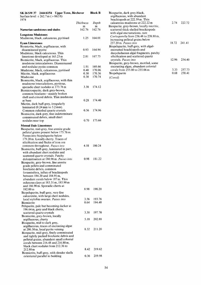
SK 26 SW 37 2444 6154 Upper Town, Birchover Block B Surface level + 262.7 m ( + 862ft) 1974
Namurian sandstones and shales
Longstone Mudstones Mudstone, black, calcareous, pyritised Eyam Limestones Biomicrite, black, argillaceous, with disseminated pyrite
Mudstone, black calcareous. Thin limestone developed at 165.23 m
Biomicrite, black, argillaceous. Thin mudstone intercalations. Disseminated and nodular pyrite common
Mudstone, black, calcareous, pyritised Micrite, black, argillaceous Mudstone Biomicrite, black, argillaceous, with thin mudstone intercalations, pyritous, sporadic chert nodules at 173.76 m
Biomicrosparite, dark grey-brown, common bioclasts-mainly broken shell and crinoid debris. Thin mudstone at base
Micrite, dark buff-grey, irregularly laminated (0.24 mm to 3.2 mm). Common euhedral quartz crystals
comminuted debris, small chert nodules near top
Biomicrite, dark grey, fine indeterminate
Monsal Dale Limestones Biosparite, mid-grey, fine arenite grade pelletal grains present below 175.76 m. Passes into biopelsparite below 179.20 m. Locally cherty. Traces of silicification and flecks of iron ore common throughout. Passes into
with abundant chert nodules and scattered quartz crystals. Patchy dolomitisation at 180.96 m. Pusses into
Biosparite, grey-brown, fine arenite grade pellets and comminuted bioclastic debris, common foraminifera, influx of brachiopods between 184.20 and 184.9 1 m, abundant corals below 187 m. Thin ochreous clays at 183.31 m, 185.90 m and 186.90 m. Sporadic cherts at 182.00 m
Biopelsparite, buff-grey, very fine calcarenite, with large chert nodules, local stylolite swarms. Pusses into
Biomicrite, buff-grey, laminated in part,
Biomicrite Pelsparite, pale but becoming darker at
196.64 m, grey and black cherts, scattered quartz crystals
argillaceous, cherty
argillaceous, traces of encrusting algae at 206.50 m, local pyrite veining
Biosparite, mid-grey, finely comminuted and tightly packed bioclastic debris and pelletal grains, abundant small colonial corals between 2 16.48 and 2 16.88 m, black chert nodules from 2 12.36 to 212.80m
orientated parallel to bedding
Biomicrite, grey-brown, locally
Biosparite, mid to dark grey,
Biomicrite, buff-grey, with slender shells
Thickness m
162.76
1.25
0.93
2.8 1
1.91 0.40 0.30 0.38
3.38
0.28
0.56
0.70
Depth m
162.76
164.0 1
164.94
167.75
169.66 170.06 170.36 1 70.74
174.12
174.40
174.96
175.66
4.58 180.24
0.98
8.98
3.56 0.64
3.30
5.18
8.32
8.42
181.22
190.20
193.76 194.40
197.70
202.88
21 1.20
219.62
0.36 219.98
2.74 222.72
18.72 241.41
Biosparite, dark grey-black, argillaceous, with abundant brachiopods at 222.59 m. Thin calcareous mudstone at 222.22 m
scattered thick-shelled brachiopods with algal encrustations, rare Codospordla from 236.48 to 238.80 m, increasing pelletal grains below 237.20 m. Passes into
encrusted brachiopods and dasycladacean algal fragments, patchy silicification and scattered quartz crystals. Pusses into 12.96
Biosparite, grey-brown, mottled, some encrusting algae, abundant colonial corals from 255.00 to 255.06 m 3.33
Biopelsparite 0.68 (Con td )
Biosparite, grey-brown, locally micritic,
Biopelsparite, buff-grey, with algal-
254.40
257.73 258.41
54

SORTING A.I.V. M 1 10 20 30
< 20.0
19.2
5
- 2
260
-
3
- 270
-
5
- 280
-
5 - 290
- - 5 - -300
- 310
SK 26 SW 37 2444 61 54 Upper Town, Birchover Block B
Biosparite, buff-grey, commonly mottled, with coarse arenite shell debris and pelletal grains. Encrusting algae and Coelosporella occur throughout. Colonial and solitary corals present
Pelsparite. Passes into Brachiopod biosparrudite; shells algal-
Brachiopod biosparrudite, dark grey- encrusted and patchily silicified
brown, intercalated calcareous mudstones
Pelsparite, pale buff-grey, current- sorted, locally graded
Brachiopod biopelsparrudite, shells abraded and rounded, rare intraclasts, patchy silicification
Pelsparite, buff-grey Biosparite, dark grey-black, with abundant finely comminuted bioclastic and pelletal debris. Black chert nodules common
Tuff, laminated with pyrite nodules Biosparite, dark grey-black,
argillaceous, rudite brachiopod debris common locally
Mudstone, black
Lower Matlock Lava Basalt, greyish green, amygdaloidal Borehole completed at 301.54 m
5.72 264.13 1.39 265.52
1.82 267.34
1.07 268.41
2.90 271.30
1.34 272.64 3.97 276.61
17.58 294.19 1.49 295.60
3.54 298.98 0.10 299.08
2.46 30 1.54
B sw
2 37
55

M 0
10
20
30
40
50
60
70
80
90
100
LITHOLOGY COLOUR MECHANICAL PROPERTIES
SORTING STRENGTH INDEX
(Is MN/M)
v
I Jn I U
+++++. +++++. +++++. +++++. +++++. +++++. +++++. +++++. +++++, +++++, +++++. +++++, ++++-i- +++++, +++++. +++++, U Fe Si
a
a :: .. .. A ... ... Fe
A " ..... Qiz'.'.' .' .
.'f a .!. - .. ... _....I
u Si
-X Qtz
A 0
-
0 50
I i. \
! I \ j ! i i i
I
3 7
A.I.V. I 20 30 40 - L
J
RESIDUE DATA INSOLUBLE
B 5 10 15
21.6 15.4
SE23
10
20
30
40
50
60
70
90
56

SK 26 SE 23 2571 6895 Gurdall, Wensley Block B Surfacelevel +216.3m (+710ft) Dando 250 (waterflush) 56 mm diameter October 1975
Thickness Depth
Topsoil 2.20 2.20 m m
Eyam and Monsal Dale Limestones Dolomite, buff, fine-grained, locally
granular and vuggy, with abundant brachiopod debris between 18.53 and 21.45 m, black chert nodules present between 2.43 and 4.50 m and at 21.10 m 19.25 21.45
Biosparite; tightly-packed comminuted bioclastic and pelletal debris, chert nodules present to 23.85 m, patchy silicification, flecks of pyrite occur below 23.40 m
Dolomite, buff-yellow Biosparite; fine-grained bioclastic debris
Dolomite. Fluorite vein at 33.90 m Biosparite; finely comminuted bioclastic
debris showing traces of silicification, abundant pyrite in lower 0.1 m
set in an argillaceous matrix
5.59 27.04 4.08 31.12
2.25 33.37 1.01 34.38
2.50 36.88 Upper Matlock Lava Basalt, weathered, with included mudstone fragments, grey-green. pyritous
Basalt, amygdaloidal, pyritous 3.07 39.95
13.63 53.58
5.39 68.09
Monsal Dale Limestones Brachiopod biosparite, mainly comminuted indeterminate bioclastic debris, scattered brachiopod shells, coral (Syringopora) at 54.63 m. Patchy silicification, pyritous at top. Clay (0.20 m) at 56.06 m 7.66 61.24
Algal brachiopod biopelsparite, algal- encrusted shells and Coelosporella fragments common 0.76 62.00
Brachiopod biosparite, prominent bioturbational mottling below 62.60 m. Passes into 0.70 62.70
Algal brachiopod biopelsparite, mottled between 64.64 and 66.20 m, common encrusting and dasycladacean algae, colonial coral (Lithostrotion martini) at 64.55 m. Traces of barytes mineralisation at 68.09 m
bipartiturn) at 69.32 m, well-sorted pelletal debris. Continuing from 69.62 m as biopelsparite with current- sorted, algal-encrusted brachiopods. Abundant quartz crystals
Pelsparite, coral (Dibunophyllurn
Pelsparite Biosparite, medium arenite, grade
debris, coral (Chaetetes depressus (Fleming), at 75.94 m, scattered partly silicified brachiopods. Passes into
mottled, coral (Palaeosmilia regia) at 78.40 m
Brachiopod biosparite, buff-grey,
Biopelsparite Brachiopod biosparite; broken brachiopod and other indeterminate shell debris, some patchy silicification. Clay-coated stylolites, some closely- spaced.
alternating bands of current-sorted brachiopod debris and fine pelletal bands
Algal brachiopod biopelsparite;
3.91 72.00 0.67 72.67
3.56 76.23
1.90 78.13 0.67 78.80
3.60 82.40
1.03 83.43
57
Brachiopod biosparrudite, mid-grey, becoming dark grey below 84.78 m, locally abundant Coelosporella. Patchy silicification of brachiopod debris, scattered quartz crystals 2.01 85.44
Pelsparite 2.08 87.52 Biosparite, brachiopod debris
predominant, subordinate fine arenite pelletal grains, sporadic corals. Patchy dolomitisation from 91.29 to 91.68 m 9.59 97.1 1
common especially near top, abundant tightly-packed, finely comminuted bioclastic debris. Scattered euhedral quartz crystals below 98.87 m 3.09 100.20
Biosparite, dark grey; brachiopods
Borehole completed at 100.20 m
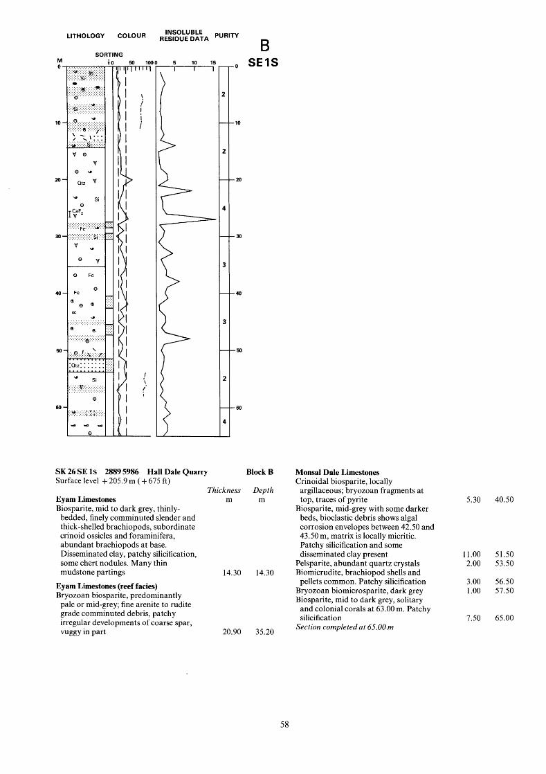
LITHOLOGY COLOUR
SORTING M 1 n ............. . . . . . . . . . . . . . . ~ ...... :.. ::.H ::.:.:::- .iri ,:,:,.,.,.
. . . . I.. ::::::: 0
. . . . . . . . . . . . . . .s ..... 4:. ..
......... ~ (.... ....... b.1:
. . . . . . . . . . . . . . .
. . . . . . . . . . . . . . . . . . .............. .............. .............. .o'.
'si ............... ......
.Q . . . . . v . . . .
/ ,\::: .I, . . . . I..'.'......
v 0
. ......... . . . . . . . ......... v:..:: . . . . . . . . . . . . . . . . . . . . . . . . . . . . . . . . . . . . . . . . . . . . . . . . . .
.............. .............. . . . . . . . . . . . . . . . . . . . . . . . . . . . . . . . . . . . . . . . . . . .e! 1:: . . . . \ z . .''7"" . . . . . . . . . . . . . . . . . . . . . . . . . . . . . . .
L
V 0 u
Qtz
Si 0
.CaF2
. v
....... Fe.'.'.'.'W.'.'f
........ .si :'::. .:.
- ................ ................ ................ ..............- ......... ......... ......... .- v u
0 v
0 Fe
Fe 0 -
e 0 e!
e! e
1:: .:. 02
- * ... . . . . . . . . . . . .............. . . . . . . . . . . . . . . . . . . . . . . . . . .-
. . . . . . . . . . . . . .- . . . . . . . . . . . . . . . . . . . . . . . . . . . . . . . . . . . . . . . . ~.'.'.'.'.'.'.
:..?..~....!.:.&::: . . . . . . . m;'; .:; ;;
Qtz:: : : : : : ! : ! ;'.;
si . . . . . . . . . . . .y:1:.:.:.:.:.:.:.:. . . . . . . . . . . . . . . . . . . . . . . . . . . . . . . . . . . . . . . . .
0
......... ..:1.:... .. . . . . . . . . . ... . . . :::, ..:v:. ....
co--s
I I I
) I
I I I
I I I
I I I I I I I I
I I I
I I
I I
I I I
> I
\.
! i
I \ ,
!
41
RESIDUE DATA INSOLUBLE
r 5 10 15
. I O
- 20
-30
-40
-50
- 60
SK 26 SE 1s 2889 5986 Hall Dale Quarry Block B Surface level + 205.9 m ( + 675 ft)
Thickness Depth Eyam Limestones m m Biosparite, mid to dark grey, thinly-
bedded, finely comminuted slender and thick-shelled brachiopods, subordinate crinoid ossicles and foraminifera, abundant brachiopods at base. Disseminated clay, patchy silicification, some chert nodules. Many thin mudstone partings 14.30 14.30
Eyam Limestones (reef facies) Bryozoan biosparite, predominantly
pale or mid-grey; fine arenite to rudite grade comminuted debris, patchy irregular developments of coarse spar, vuggy in part 20.90 35.20
Monsal Dale Limestones Crinoidal biosparite, locally
argillaceous; bryozoan fragments at top, traces of pyrite
Biosparite, mid-grey with some darker beds, bioclastic debris shows algal corrosion envelopes between 42.50 and 43.50 m, matrix is locally micritic. Patchy silicification and some disseminated clay present
Pelsparite, abundant quartz crystals Biomicrudite, brachiopod shells and pellets common. Patchy silicification
Bryozoan biomicrosparite, dark grey Biosparite, mid to dark grey, solitary
and colonial corals at 63.00 m. Patchy silicification
Section completed at 65.00 m
5.30 40.50
11.00 51.50 2.00 53.50
3.00 56.50 1.00 57.50
7.50 65.00
58

M 0 .
10 -
20 -
30-
40-
LITHOLOGY COLOUR
SORTING I
RESIDUE DATA PUR'TY INSOLUBLE
B 5 10 15 111
2 47.13
SK 26 SE 2s 2865 6064 Cawdor Quarry Block B Surface level + 101.5 m (+ 333 ft)
Eyam Limestones Shale, black, thin-bedded; many brachiopods
Biomicrite, dark brown-black, very argillaceous, flecks of pyrite
Shale Biomicrite, dark brown-black; comminuted brachiopod and crinoid debris. Patchy silicification. Flecks of pyrite
Shale, black, rare pyritised brachiopods Biomicrite, black, argillaceous with flecks of pyrite and patchy silicification
Shale Biomicrite, black, pyritous, silicified Shale Biomicrite, dark grey, argillaceous, spar cement developed locally. Abundant chert and patchy silicification
Clay, grey Monsal Dale Limestones Biosparite, lightly mottled; abundant spines
Biosparite, pellets common throughout, broken corals present at 27.00 m, clusters of brachiopods at 27.00, 30.00 and 33.00 m. Patchy silicification and locally abundant quartz crystals
Biosparlutite; disseminated pyrite Biosparite; some disseminated clay.
Calcite vein containing galena at 38.00 m
Section completed at 42.50 m
Thickness m
3 .OO
0.10 4.10
0.80 2.90
0.20 0.70 1.10 0.70
7.80 0.20
1.30
13.00 1 .oo
6.00
Depth m
3.00
3.10 7.20
8.00 10.90
11.10 1 1.40 12.50 13.20
21 .oo 21.20
22.50
35.50 36.50
42.50
59

SORTING
S K 26 SE 3s 2677 6033 Northern Dale Surface level + 2 13.4 m (+ 700 ft)
Eyam Limestones m Biomicrite, mid-grey to 2.00 m,
Thickness
continuing dark grey to base; rolled brachiopods and scattered crinoid debris 4.00
Brachiopod biomicrosparrudite, dark grey; clay wisps in matrix 1 .oo
Biomicrosparite passing down into biomicrite, dark grey; finely comminuted bioclastic debris 7.00
Eyam Limestones (reef facies) Crinoidal biomicrosparite, with
abundant coarse arenite to rudite size crinoid debris and rare bryozoa 1 1 .oo
Section completed at 23.00 m
Block B
Depth m
4.00
5.00
12.00
23.00
LITHOLOGY COLOUR
SORTING M 0
10
M I I I I I
RESIDUE DATA PUR'TY INSOLUBLE
B - 5 10 15
i SI( 26 SE 4s 2701 6060 Northern Dale Surface level + 144.8 m ( + 475 ft)
Eyam Limestones Biomicrite, dark grey, rarely fossilferous,
disseminated clay in matrix Biomicrosparite; massive Lithostrotion junceum colony, rare brachiopods
Biomicrite, dark grey, rare brachiopods Biomicrite, dark grey, Lithostrotion junceurn colony at 8.50 m, argillaceous matrix
Section completed at 9.00 m
Block B
Thickness Depth m m
3.00 3.00
3.00 6.00 2.00 8.00
1.00 9.00
60

APPENDIX D
ANALYTICAL RESULTS
Rapid instrumental and chemical methods of analysis were used. The table below shows estimated confidence limits at the 95% probability level for results on the very high, high and medium purity (293.5:'; CaCO,) limestone, together with the determination limits below which the accuracy is uncertain. The detection limits, which are also shown, are the concentrations of each element reproducibly measurable above the instrumental background signal. For impure limestones, the accuracy is uncertain due to inter-element interference effects. Some results may therefore lie outside the tolerances obtainable using standard or referee chemical methods of analysis.
Estimated 95% Lower Detection confidence limits determination limit
limit
k per cent CaO 0.80
Na2 0 0.02 F 0.10 SiO, 0.10 MgO 0.14 A1203 0.10 K2O 0.02 Fe203 0.12 p205 0.02
so3 0.10
Loss at 1050°C 0.15
per cent 50.00 0.10 0.02 0.05 0.10 0.10 0.10 0.02 0.10 0.05 -
per cent - 0.0 I 0.02 0.03 0.02 0.02 0.0 1 0.01 0.05 0.02
-t PPm PPm PPm c u 10 3 1 Pb 10 3 1 Zn 20 5 2 Acid-soluble MnO 20 10 3 Acid-soluble
As 2 2 1 Fe2 '3 20 10 3
61

CHEMICAL ANALYSES
Depth* percentages parts per million (m) CaO SO, Na,O F SiO, MgO Al,O, K,O P,O, Loss at Cu Pb Zn MnO As Fe,O,
105OOC
NW 2074 6826 Stonedge Lane Block A 5.00 40.40 0.03 0.05 0.01 33.00 0.28
NW 12 2077 6897 Field House Block A 10.00 42.30 0.58 0.07 0.1 1 21.001 0.85 15.00 53.00 0.17 0.04 0.17 1.00 0.64 27.00 42.90 0.27 0.04 0.08 28.003: 0.55 38.00 53.50 0.52 0.04 0.05 2.01 0.66 44.00 54.60 0.17 0.03 0.04 1.84 0.47 50.00 46.10 0.19 0.04 0.05 25.001 0.47 5 1 .OO 53.50 0.18 0.04 0.20 1.37 1.22 57.00 41.70 0.76 0.04 0.07 29.001 0.51 63.00 51.00 0.30 0.04 0.03 5.40 0.52
NW 13 2142 6587 Conksbury Bridge Block A 8.00 43.40 0.10 0.03 0.00 27.001 0.61
18.00 45.50 0.03 0.03 0.00 23.001 0.16 14.00 54.50 0.1 1 0.03 0.00 0.91 0.29
25.00 54.70 0.08 0.03 0.01 1.17 0.30 3 1 .OO 37.70 0.00 0.03 0.01 42.001 0.16 38.00 54.90 0.10 0.03 0.00 0.79 0.29 82.00 54.90 0.07 0.03 0.00 0.71 0.24
NW 14 2369 6585 Nutseats Quarry Block A 3.00 47.80 0.24 0.04 0.05 16.001 0.45
10.00 55.40 0.08 0.03 0.00 0.20 0.17 20.00 54.20 0.1 3 0.03 0.01 0.57 0.27 30.00 54.90 0.07 0.03 0.01 0.24 0.23 34.00 43.90 0.05 0.03 0.01 25.00: 0.23 40.00 55.40 0.17 0.03 0.01 1.06 0.34
SW 36 23256458 Bowers Hall Block A 18.00 37.90 0.03 0.04 0.07 39.001 0.21 25.00 52.60 0.29 0.04 0.02 2.77 0.62 32.00 47.70 0.1 1 0.04 0.01 14.50 0.41 39.00 47.60 0.18 0.03 0.03 14.80 0.25 48.00 53.10 0.16 0.04 0.03 1.81 0.34 65.00 54.10 0.04 0.04 0.00 0.44 0.29 77.00 44.40 0.31 0.04 0.04 20.001 0.40 85.00 53.00 0.38 0.04 0.02 1.82 0.49
93.00 47.80 1.01 0.05 0.08 10.60 0.51 125.00 54.40 0.10 0.03 0.02 0.66 0.25
NW 1 S 2133 6945 Holmebank Chert Quarry Block A
88.00 42.70 0.20 0.04 0.06 28.001 0.28
8.00 54.20 0.45 0.05 0.08 1.88 0.54
NW 2 S 21366894 Endcliff Wood Block A 8.00 55.60 0.27 0.04 0.02 0.50 0.39
12.00 53.40 0.30 0.04 0.03 4.54 0.33
NW 3 S 2111 6819 Bank Top House Block A 7.00 32.10 0.18 0.03 0.07 46.00: 0.22
12.00 54.80 0.30 0.03 0.01 1.31 0.33
NW 4 S 2382 6577 Nutseats Quarry Block A 4.00 53.70 0.55 0.04 0.14 2.64 0.58
NW 5 S 2283 6505 Shining Bank Quarry Block A 4.00 51.10 0.49 0.04 0.03 8.53 0.50
15.00 55.80 0.46 0.03 0.03 0.58 0.26 23.00 51.00 0.33 0.04 0.02 10.04 0.29
NW 6 S 2034 6608 Lathkill Lodge Block A 4.00 54.90 0.18 0.03 0.02 1.42 0.48
13.00 55.60 0.16 0.03 0.01 0.64 0.35
NW 7 S 2134 6556 Conksbury Bridge Block A 1 1 .oo 48.50 0.12 0.03 0.00 15.001 0.29 20.00 40.00 0.18 0.03 0.01 31.00$ 0.21
12.00 54.60 0.14 0.03 0.00 2.40 0.21 18.00 50.40 0.16 0.03 0.02 11.30 0.22
NW 8 S 2093 6498 Conksbury Lane Block A
SW 1 S 2321 6397 Stanton Mill Quarry Block A 6.00 25.70 0.07 0.04 0.01 55.00$ 0.21
15.00 55.10 0.16 0.03 0.02 1.91 0.32
SW 2 S 2287 6464) Alport Flour Mill Block A 3.00 55.10 0.11 0.03 0.01 0.74 0.34
13.00 55.80 0.1 1 0.03 0.01 0.69 0.31
0.04 0.02 0.06
2.96 0.51 0.16 0.24 0.06 0.16 0.51 0.12 0.08 0.46 0.12 0.08 0.09 0.04 0.06 0.29 0.08 0.05 0.07 0.05 0.02 0.88 0.19 0.06 0.46 0.12 0.03
0.03 0.03 0.05 0.37 0.08 0.06 0.12 0.04 0.05 0.28 0.06 0.07 0.01 0.02 0.08 0.04 0.03 0.03 0.07 0.04 0.04
0.12 0.03 0.04 0.04 0.03 0.03 0.25 0.06 0.06 0.06 0.03 0.04 0.14 0.04 0.06 0.09 0.04 0.05
0.03 0.02 0.12 0.29 0.07 0.08 0.16 0.04 0.04 0.01 0.02 0.03 0.49 0.12 0.1 1 0.06 0.04 0.03 0.72 0.14 0.17 0.14 0.05 0.03 0.1 1 0.04 0.04 0.97 0.19 0.05 0.00 0.03 0.03
0.58 0.15 0.14
0.03 0.03 0.01 0.10 0.04 0.00
0.01 0.01 0.04 0.00 0.02 0.04
0.28 0.08 0.38
0.03 0.02 0.05 0.03 0.03 0.01 0.22 0.04 0.04
0.16 0.06 0.02 0.00 0.03 0.01
0.22 0.05 0.02 0.19 0.04 0.06
0.00 0.02 0.00 0.24 0.03 0.02
0.37 0.06 0.13 0.00 0.03 0.26
0.01 0.03 0.04 0.03 0.03 0.01
62
30.20
35.02 43.08 32.08 42.8 1 43.02 34.49 43.27 31.60 41.58
32.23 43.38 33.06 43.18 26.49 43.68 43.55
35.53 43.94 43.36 43.69 31.38 43.16
27.50 42.61 36.89 36.42 42.68 43.71 33.37 43.31 3 1.84 35.32 43.64
42.74
43.86 41.22
21.91 43.55
41.73
39.35 43.60 38.68
43.24 43.68
35.62 28.70
42.82 37.92
18.36 43.10
43.60 43.41
0 0 10
30 0 120 10 0 70 10 0 60 5 0 70 5 30 60 5 10 40 5 0 30
10 60 240 5 10 80
5 0 60 5 0 40 5 0 10 5 10 70 5 0 10 5 20 40 5 0 0
5 480 50 5 10 30 5 0 20 5 0 0 5 0 0 5 0 30
5 130 80 5 20 170 5 10 80 0 20 90 5 40 190 0 0 40 0 10 150
10 30 110 0 0 40 0 10 120 0 0 10
5 0 100
0 10 20 5 0 20
0 0 10 0 0 20
5 0 60
5 20 150 5 90 80 5 80 100
0 0 10 0 0 10
0 0 50 5 10 70
5 100 40 0 50 30
5 70 190 0 0 40
0 0 40 5 10 50
110
2500 900 300 340 200 120 420 150 310
230 290 310 200
80 280 370
270 200 190 110 110 240
160 130 270 120 170 100 140 90 70 90
160
310
135 170
125 215
950
145 120 140
220 360
160 200
250 155
150 490
125 140
- 180
- 11600 4 1200 - 1600 - 2200 - 750 - 1400 2 1100 - 4800 - 2400
3 800 - 1200 - 200 - 2100 - 180 - 700 4 350
- 1500 4 140 - 1100 - 110 - 110 2 160
- 780 - 1500 - 300 - 1300 - 2400 1 250
2 1300 - 2700
- 1400 - 5700 - 270
1 5300
- 1500 - 1100
- 500 0 100
- 2500
- 220 1 1700 - 2200
- 600 - 600
- 500 - 900
0 500 0 350
- 3800 - 470
- 220 0 700

CHEMICAL ANALYSES
Depth* percentages parts per million (m) CaO SO, Na,O F SiO, MgO Al,O, K,O P20, Loss at Cu Pb Zn MnO As Fe,O,
105OOC
SW 3 S 2164 6416 6.00 54.60
SW 4 S 2318 6473 5.00 54.20
10.00 55.40
SW 5 S 2015 6381 5.00 42.30
11 .oo 54.20 27.00 51.30 50.00 51.40
SW 6 S 2169 6494 4.00 54.70
SW 7 S 2197 6479 5.00 5 1.40
SW 18 2035 6034 16.00 3 1.70 25.00 5 1.90 40.00 53.60 51 .OO 4.3.YO 62.00 55.70 75.00 53.90 85.00 36.80 95.00 53.70
106.00 51.80 120.00 54.10 133.00 5 1 .OO 142.00 52.30
SW 19 2027 6025 10.00 30.90 24.00 33.20 40.00 34.10 54.00 50.20 59.00 45.50 65.00 52.80 73.00 44.80 85.00 51.80 95.00 52.60
105.00 54.70 1 15.00 53.40 130.00 53.70 140.00 55.60 150.00 53.80 160.00 52.80
SE 23 2571 6095 10.00 3 I .90 23.00 49.60 33.00 47.30 60.00 53.90 68.00 53.00 80.00 54.00 90.00 54.50 97.00 54.20
SE 1 S 2889 5986 14.00 53.30 22.00 51.50 27.00 53.60 38.00 52.40 48.00 52.00
SE 2 S 2865 6064 15.00 29.30 20.00 41.60 28.00 52.50 38.00 5 1.90
SE 3 S 2677 6033 5.00 55.20
17.00 54.70
SE 4 S 2701 6060 4.00 54.70
Bradford Dale Block A 0.14 0.04 0.02 2.03
Harthill Lodge Block A 0.18 0.04 0.06 3.14 0.15 0.03 0.01 0.62
Bradford Dale Block A 0.07 0.03 0.06 27.001 0.09 0.03 0.02 3.95 0.19 0.03 0.01 9.44 0.56 0.04 0.06 5.27
Lathkill Dale Block A 0.18 0.03 0.03 2.18
Lathkill Dale Block A 0.16 0.03 0.02 8.60
Gratton Moor Block B 0.00 0.05 - 26.00: 0.01 0.03 - 4.23 0.04 0.03 - 2.03 1.37 0.07 - 13.50 0.03 0.04 - 1.15 0.05 0.04 - 0.94 2.00 0.09 - 22.001 0.07 0.03 - 2.03 0.03 0.03 - 6.12 0.02 0.03 - 1.17 0.03 0.03 - 6.54 0.67 0.04 - 4.27
Gratton Moor Block B 0.1 1 0.06 - 3.84 0.0.3 0.05 - 0.19 0.04 0.06 - 1.49 0.13 0.04 - 1.80 0.12 0.04 - 1.55 0.08 0.03 - 4.05 0.21 0.04 - 13.10 0.09 0.03 - 5.95 0.1 1 0.03 - 1.45 0.13 0.03 - 0.83 0.12 0.03 - 2.31 0.10 0.03 - 2.83 0.08 0.03 - 1.97 0.10 0.03 - 2.29 0.14 0.03 - 2.67
Gurdall, Wensley Block B 0.02 0.05 0.01 0.86 0.15 0.04 0.02 8.50 2.26 0.05 1.68 2.69 0.15 0.04 0.03 0.68 0.15 0.03 0.06 1.86 0.04 0.03 0.01 0.76 0.10 0.05 0.01 0.58 0.20 0.04 0.02 0.28
Hall Dale Quarry Block B 0.13 0.05 0.02 3.90 0.07 0.04 0.03 7.41 1.77 0.04 3.93 0.54 0.14 0.04 0.06 3.91 0.10 0.03 0.06 6.1 1
Cawdor Quarry Block B 0.38 0.06 0.03 56.001 0.37 0.05 0.03 26.001 0.08 0.04 0.03 3.97 0.20 0.04 0.59 5.01
Northern Dale Block B 0.13 0.03 0.00 0.49 0.14 0.03 0.02 1.15
Northern Dale Block B 0.12 0.03 0.01 2.12
0.3 1
0.3 1 0.37
0.24 0.22 0.37 0.42
0.24
0.48
10.50 0.84 0.58 0.88 0.43 0.48 0.9 1 0.43 0.30 0.37 0.69 0.28
19.90 19.80 18.60 3.65 7.80 0.5 1 3.00 0.66 1.80 0.27 0.30 0.28 0.32 0.3 1 0.4 1
19.90 0.63 2.80 0.42 0.40 0.5 1 0.43 0.50
0.45 0.3 1 0.15 0.3 1 0.33
1 .oo 0.9 1 0.3 1 0.32
0.33 0.3 1
0.34
0.06
0.03 0.07
0.17 0.1 1 0.36 1.54
0.37
0.12
0.29 0.00 0.03 5.50 0.1 1 0.22 8.20 0.25 0.06 0.30 0.24 0.22
0.01 0.00 0.00 0.16 0.08 0.02 0.46 0.04 0.13 0.06 0.10 0.06 0.09 0.04 0.10
0.00 0.32 0.37 0.10 0.52 0.06 0.2 1 0.07
0.14 0.05 0.07 0.42 0.09
0.59 0.28 0.08 0.33
0.02 0.23
0.00
0.03
0.03 0.03
0.04 0.05 0.04 0.28
0.09
0.04
0.06 0.02 0.03 1 .oo 0.05 0.07 1.49 0.08 0.04 0.08 0.09 0.07
0.03 0.02 0.03 0.06 0.04 0.03 0.12 0.03 0.05 0.04 0.05 0.04 0.05 0.04 0.05
0.03 0.08 0.10 0.04 0.09 0.04 0.06 0.04
0.04 0.04 0.04 0.12 0.04
0.12 0.07 0.04 0.10
0.03 0.07
0.02
0.01
0.03 0.02
0.04 0.03 0.00 0.03
0.04
0.02
0.01 0.02 0.00 0.04 0.00 0.02 0.10 0.01 0.0 1 0.01 0.02 0.02
0.05 0.03 0.03 0.0 1 0.02 0.0 1 0.1 1 0.02 0.02 0.0 1 0.03 0.01 0.0 1 0.02 0.0 1
0.04 0.07 0.04 0.06 0.02 0.02 0.02 0.04
0.03 0.06 0.04 0.12 0.02
0.16 0.10 0.02 0.15
0.02 0.06
0.01
42.69
42.24 43.68
29.28 41.68 39.20 40.05
42.73
39.29
34.00 42.00 43.04 34.65 43.35 43.44 29.44 43.12 40.66 43.77 40.46 40.69
44.93 47.39 46.52 43.47 43.86 41.79 36.52 40.97 43.53 43.53 42.64 42.39 42.87 42.66 42.53
46.79 38.60 37.68 43.48 42.63 43.66 43.63 43.84
42.02 40.03 36.52 41.34 40.19
23.77 33.29 42.09 40.63
43.63 43.10
42.74
60 240
90 185 60 190
180 125 140 470 20 125
150 1100
80 450
40 300
- 900 - 420 - 190 - 160 - 70 - 130 - 170 - 130 - 140 - 100 - 250 - 150
- 830 - 770 - 760 - 940 - 1300 - 530 - 870 - 260 - 500 - 310 - 670 - 190 - 180 - 130 - 420
160 1100 20 110
530 1400 40 250
110 250 40 140 70 130
350 130
0 150 10 430 20 550 60 350 30 170
460 390 230 200 40 120
130 520
10 240 30 310
40 145
- 470
- 1100 1 1400
- 150 4 1300 - 220 - 8700
0 2600
- 600
- 3700 - 2100 0 1700 - 16300 - 360 - 1500 - 26500 - 1400 - 400 1 480 - 1400 - 4400
- 2100 - 2300 - 2400 - 4000 - 5600 6 1100 - 4200 - 430 - 1600 - 540 7 1400 - 420 4 320 - 200 3 1300
- 4100 - 1400 - 7300 0 1200 - 2400 - 1400 - 1600 1 250
- 140 - 300 - 2300 - 1400 - 600
- 4100 - 1700 0 1500 - 2700
- 220 - 700
- 420
* Represents the depth below the surface of the mid-point of the sample. t The numbers of all the boreholes quoted in this table have the prefix SK 26. 1 Silica values above 15% have been rounded to the nearest integer.
63

REFERENCES
AITKENHEAD, N., CHISHOLM, J. I . and STEVENSON, I . P. In preparation. Geology of the country around Buxton, Leek and Bakewell. Mem. Geol. Surv. G. B., Sheet 1 1 1.
sampling and testing oj'mineral aggregates, sands and,filler. B.S. 812 (Part 3 ) . 18 pp. (London: British Standards Institution.)
Carboniferous Limestone of Monsal Dale, Derbyshire. Mercian Geol., Vol. 4, 179-195.
the Wye Valley region of north Derbyshire. J . Manchester Geol. Assoc., Vol. 1, Part 3, 125-145.
Cox, F. C. and BRIDGE, D. McC. 1977. The limestone and dolomite resources of the country around Monyash, Derbyshire. Description of 1 :25 000 resource sheet SK 16. Miner. Assess. Rep. Inst. Geol. Sci., No. 26, 137 pp.
- - and HULL, J. H. 1977. A procedure for the assessment of limestone resources. Miner. Assess. Rep. Inst. Geol. Sci., No. 30.
- and HARRISON, D. J. 1980. The limestone and dolomite resources of the country around Wirksworth, Derbyshire. Description of 1 :25 000 resource sheet SK 25 and part of SK 35. Miner. Assess. Rep. Inst. Geol. Sci., No. 47.
groundwaters in the Derbyshire Dome with special reference to trace constituents. Rep. Inst. Geol. Sci., No. 7 117, 52 pp.
FOLK, R. L. 1959. Practical petrographic classification of limestones. Bull. Am. Assoc.. Pet. Geol., Vol. 43, No. 1 ,
FORD, T. D. 1969. Dolomite tors and sand-filled sinkholes in the carboniferous Limestones of Derbyshire, England. In The periglacial environment, PEwE, T. L. (editor). (McGill: Queen's University Press.)
- and KING, R. J. 1965. Epigenetic layered galena-baryte deposits in the Golconda Mine, Brassington, Derbyshire. Econ. Geol., Vol. 60, 1686-1702.
Derbyshire limestone. Mercian Geol., Vol. 3, No. 1 ,
BRITISH STANDARDS INSTITUTION. 1975. Methods,for
BUTCHER, N. J. D. and FORD, T. D. 1973. The
COPE, F. W. 1933. The Lower Carboniferous succession in
EDMUNDS, W. M. 197 1. Hydrogeochemistry of
1-38.
_ _ 1969. The origin of the silica sand pockets in the
5 1-69. FRANKLIN, J. A,, BROCH, E. and WALTON, G. 1971. Logging
the mechanical character of rock. Trans. Inst. Min. & Metall., Vol. 80, Ser. A. 1-9.
FROST, D. V. and SMART, J. G. 0. 198 1. The geology of the country north of Derby. Mem. Geol. Sur\?. G. B., Sheet 125.
a symposium. 279 pp. (Tulsa, Oklahoma: American Association of Petroleum Geologists.)
INDUSTRIAL MINERALS. 1976. Dolomite. 2. Consuming industries. Ind. Miner., No. 102, 25-35.
INSTITUTE OF GEOLOGICAL SCIENCES. 1980. United Kingdom Mineral Statistics 1979. (London: HMSO.)
MOLINIA, B. F. 1974. A rapid and accurate method for analysis of calcium carbonate in small samples. J . Sediment. Petrol., Vol. 44, No. 2, 589-590.
Limestone of the Midlands. Geol. Mag., Vol. 59, 5 1-63 and 104-1 16.
M. E. 1962. Energy index for limestone interpretation and classification. In Classification oj'carbonate rocks: a symposium, HAM, W. E. (editor). (Tulsa, Oklahoma: American Association of Petroleum Geologists.)
Reproducibility of results in the aggregate impact test. Quarry Manugers'J., May 1973, 179-181.
RAMSBOTTOM, W. H. C., RHYS, G. H. and SMITH, E. G. 1962. Boreholes in the Ashover district, Derbyshire. Bull. Geol. Surv. G.B., No. 19, 75-1 68.
ROBERTS, J. L. and DAVIS, A. E. 1977. Analysis of limestone survey samples by direct electron excitation X-ray spectrometry. Rep. Inst. Geol. Sei., No. 7713, 7 pp.
HAM, W. E. (editor). 1962. Classijication of'carbonate rocks:
PARSONS, L. M. 1922. Dolomitization in the Carboniferous
PLUMLEY, W. J., RISLEY, G. A., GRAVES, R. W. and KALEY,
RAMSAY, D. M., DHIR, R. K. and SPENCE, J. M. 1973.
SHIRLEY, J. 1950. The stratigraphical distribution of the lead-zinc ores of Millclose Mine, Derbyshire and the future prospects in this area. Rep. 18th Sess. Int. Geol. Congr., London 1948, Vol. 7,353-361.
Wirksworth area, Derbyshire. Q. J . Geol. Soc. London, - 1959. The Carboniferous Limestone of the Monyash-
Vol. 114,411-429. - and HORSFIELD, E. L. 1940. The Carboniferous
Limestone of the Castleton-Bradwell area, north Derbyshire. Q. J . Geol. Soc. London, Vol. 96,271-299.
of the country around Chesterfield, Matlock and Mansfield. Mem. Geol. Surv. G. B., Sheet 1 12.
STEVENSON, 1. P. and GAUNT, G. D. 1971. Geology of the country around Chapel-en-le-Frith. Mem. Geol. Sum. G. B., Sheet 1 1 1.
TRAILL, J. G. 1939. The geology and development of Millclose Mine, Derbyshire. Econ. Geol., Vol. 34,
SMITH, E. G., RHYS, G. H. and EDEN, R. A. 1967. Geology
85 1-889. - 1940. Notes on the Lower Carboniferous limestones and
toadstones at Mill Close Mine, Derbyshire. Trans. Inst. Min. Metall., Vol. 49, 191-229.
interbedded clay wayboards in the Lower Carboniferous of the Derbyshire Dome. Geol. J . , Vol. 8, Part 1, 143-160.
(Carboniferous) limestones of the Derbyshire Block, England. J . Sedinzent. Petrol., Vol. 44, 1232-1247.
WALKDEN, G. M. 1972. The mineralogy and origin of
- 1974. Palaeokarstic surfaces in the Upper Visean
64
The following reports of the Institute relate particularly to bulk mineral resources
Reports of the Institute of Geological Sciences
Assessment of British Sand and Gravel Resources
1 The sand and gravel resources of the country south-east of Norwich, Norfolk: Resource sheet TG 20. E. F. P. Nickless. Report 71/20 ISBN 0 11 880216 E1.15 2 The sand and gravel resources of the country around Witham, Essex: Resource sheet TL 8 1. H. J. E. Haggard. Report 72/6 ISBN 0 11 880588 6 $1.20 3 The sand and gravel resources of the area south and west of Woodbridge, Suffolk: Resource sheet TM 24. R. Allender and S. E. Hollyer. Report 72/9 ISBN 0 11 880596 7 $1.70 4 The sand and gravel resources of the country around Maldon, Essex: Resource sheet TL 80. J. D. Ambrose. Report 73/1 ISBN 0 11 880600 9 E1.20 5 The sand and gravel resources of the country around Hethersett, Norfolk: Resource sheet TG 10. E. F. P. Nickless. Report 73/4 ISBN 0 1 1 880606 8 E1.60 6 The sand and gravel resources of the country around Terling, Essex: Resource sheet TL 7 1. C. H. Eaton. Report 73/5 ISBN 0 11 880608 4 E1.20 7 The sand and gravel resources of the country around Layer Breton and Tolleshunt D’Arcy, Essex: Resource sheet TL 91 and part of TL 90. J. D. Ambrose. Report 73/8 ISBN 0 11 880614 9 E1.30 8 The sand and gravel resources of the country around Shotley and Felixstowe, Suffolk: Resource sheet TM 23. R. Allender and S. E. Hollyer. Report 73/13 ISBN 0 11 880625 4 E1.60 9 The sand and gravel resources of the country around Attlebridge, Norfolk: Resource sheet TG 1 1. E. F. P. Nickless. Report 73/15 ISBN 0 1 1 880658 0 E1.85 10 The sand and gravel resources of the country west of Colchester, Essex: Resource sheet TL 92. J. D. Ambrose. Report 74/6 ISBN 0 11 880671 8 E1.45 1 1 The sand and gravel resources of the country around Tattingstone, Suffolk: Resource sheet TM 13. S. E. Hollyer Report 74/9 ISBN 0 1 1 880675 0 E1.95 12 The sand and gravel resources of the country around Gerrards Cross, Buckinghamshire: Resource sheet SU 99, TQ 08 and TQ 09. H. C. Squirrell. Report 74/14 ISBN 0 1 1 880710 2 E2.20
Mineral Assessment Reports
13 The sand and gravel resources of the country east of Chelmsford, Essex: Resource sheet TL 70. M. R. Clarke. ISBN 0 11 880744 7 E3.50 14 The sand and gravel resources of the country east of Colchester, Essex: Resource sheet TM 02. J. D. Ambrose. ISBN 0 11 880745 5 E3.25 15 The sand and gravel resources of the country around Newton on Trent, Lincolnshire: Resource sheet SK 87. D. Price. ISBN 0 11 880746 3 E3.00 16 The sand and gravel resources of the country around Braintree, Essex: Resource sheet TL 72. M. R. Clarke. ISBN 0 11 880747 1 E3.50 17 The sand and gravel resources of the country around Besthorpe, Nottinghamshire: Resource sheet SK 86 and part of SK 76. J. R. Gozzard. ISBN 0 11 880748 X E3.00
18 The sand and gravel resources of the Thames Valley, the country around Cricklade, Wiltshire: Resource sheet SU 09/19 and parts of SP 00/10. P. R. Robson. ISBN 0 11 880749 8 E3.00 19 The sand and gravel resources of the country south of Gainsborough, Lincolnshire: Resource sheet SK 88 and part of SK 78. J. H. Lovell. ISBN 0 11 880750 1 E2.50 20 The sand and gravel resources of the country east of Newark upon Trent, Nottinghamshire: Resource sheet SK 85. J. R. Gozzard. ISBN 0 1 1 880751 X 52.75 21 The sand and gravel resources of the Thames and Kennet Valleys, the country around Pangbourne, Berkshire: Resource sheet SU 67. H. C. Squirrell. ISBN 0 11 880752 8 E3.25 22 The sand and gravel resources of the country north-west of Scunthorpe, Humberside: Resource sheet SE 8 1 . J. W. C. James. ISBN 0 1 1 880753 6 E3.00 23 The sand and gravel resources of the Thames Valley, the country between Lechlade and Standlake: Resource sheet SP 30 and parts of SP 20, SU 29 and SU 39. P. Robson. ISBN 0 11 881252 1 E7.25 24 The sand and gravel resources of the country around Aldermaston, Berkshire: Resource sheet SU 56 and SU 66. H. C. Squirrell. ISBN 0 11 881253 X E5.00 25 The celestite resources of the area north-east of Bristol: Resource sheet ST 68 and parts of ST 59,69,79,58,78,68 and 77. E. F. P. Nickless, S. J. Booth and P. N. Mosley. ISBN 0 11 881262 9 E5.00 26 The limestone and dolomite resources of the country around Monyash, Derbyshire: Resource sheet SK 16. F. C. Cox and D. McC. Bridge. ISBN 0 11 881263 7 E7.00 27 The sand and gravel resources of the country west and south of Lincoln, Lincolnshire: Resource sheets SK 95, SK 96 and SK 97. I. Jackson. ISBN 0 11 884003 7 E6.00 28 The sand and gravel resources of the country around Eynsham, Oxfordshire: Resource sheet SP 40 and part of SP 41. W. J. R. Harries. ISBN 0 1 1 884012 6 E3.00 29 The sand and gravel resources of the country south-west of Scunthorpe, Humberside: Resource sheet SE 80. J. H. Lovell. ISBN 0 11 884013 4 E3.50 30 Procedure for the assessment of limestone resources. F. C. Cox, D. McC. Bridge and J. H. Hull. ISBN 0 11 884030 4 E1.25 3 1 The sand and gravel resources of the country west of Newark upon Trent, Nottinghamshire: Resource sheet SK 75. D. Price and P. J. Rogers. ISBN 0 11 884031 2 E3.50 32 The sand and gravel resources of the country around Sonning and Henley: Resource sheet SU 77 and SU 78. H. C. Squirrell. ISBN 0 1 1 884032 0 E5.25 33 The sand and gravel resources of the country north of Gainsborough: Resource sheet SK 89. J. R. Gozzard and D. Price ISBN 0 1 1 884033 9 E4.50 34 The sand and gravel resources of the Dengie Peninsula, Essex: Resource sheet TL 90, etc. M. B. Simmons. ISBN 0 11 884081 9 55.00 35 The sand and gravel resources of the country around Darvel: Resource sheet NS 53,63, etc. E. F. P. Nickless, A. M. Aitken and A. A. McMillan. ISBN 0 1 1 884082 7 E7.00

36 The sand and gravel resources of the country around Southend-on-Sea, Essex: Resource sheets TQ 78/79 etc. S. E. Hollyer and M. B. Simmons. ISBN 0 11 884083 5 E7.50 37 The sand and gravel resources of the country around Bawtry, South Yorkshire: Resource sheet SK 69. A. R. Clayton ISBN 0 11 884053 3 E5.75 38 The sand and gravel resources of the country around Abingdon, Oxfordshire: Resource sheet SU 49, 59, SP 40, 50. C. E. Corser. ISBN 0 1 1 884084 5 E5.50 39 The sand and gravel resources of the Blackwater Valley (Aldershot) area: Resource sheet SU 85, 86, parts SU 84,94, 95,96. M. R. Clarke, A. J. Dixon and M. Kubala. ISBN 0 11 884085 1 E7.00 40 The sand and gravel resources of the country west of Darlington, County Durham: Resource sheet NZ 1 1,21. A. Smith. ISBNO 11 884086X E5.00 41 The sand and gravel resources of the country around Garmouth, Grampian Region: Resource sheet NJ 36. A. M. Aitken, J. W. Merritt and A. J. Shaw. ISBN 0 11 884090 8 E8.75 42 The sand and gravel resources of the country around Maidenhead and Marlow: Resource sheet SU 88, parts SU 87, 97, 98. P. N. Dunkley. ISBN 0 11 884091 6 f5.00 43 The sand and gravel resources of the country around Misterton, Nottinghamshire: Resource sheet SK 79. D. Thomas and D. Price. ISBN 0 11 884092 4 E5.25 44 The sand and gravel resources of the country around Sedgefield, Durham: Resource sheet NZ 32. M. D. A. Samuel. ISBN 0 11 884093 2 E5.75 45 The sand and gravel resources of the country around Brampton, Cumbria: Resource sheet NY 55, part 56. I. Jackson. ISBN 0 11 884094 0 E6.75 46 The sand and gravel resources of the country around Harlow, Essex: Resource sheet TL 41. P. M. Hopson. ISBN 0 1 I 884107 6 E9.50 47 The limestone and dolomite resources of the country around Wirksworth, Derbyshire: Resource sheet SK 25, part 35. F. C. Cox and D. J. Harrison. ISBN 0 11 884108 4 E15.00 48 The sand and gravel resources of the Loddon Valley area: Resource sheet SU 75,76, parts 64,65,66 and 74. M. R. Clarke, E. J. Raynor and R. A. Sobey. ISBN 0 11 884109 2 E8.75 49 The sand and gravel resources of the country around Lanark, Strathclyde Region: Resource sheet NS 94, part 84. J. L. Laxton and E. F. P. Nickless. ISBN 0 11 8841 12 2 E l 1.00 50 The sand and gravel resources of the country around Fordingbridge, Hampshire: Resource sheet SU 11 and parts of SU 00,01, 10, 20 and 21. M. Kubala. ISBN 0 11 8841 11 4 E7.75 5 1 The sand and gravel resources of the country north of Bournemouth, Dorset: Resource sheet SU 00, 10,20, SZ 09, 19
ISBN 0 1 1 8841 10 6 E9.75 52 The sand and gravel resources of the country between Hatfield Heath and Great Waltham, Essex: Resource sheet TL 51 and 61. R. J. Marks. ISBN 0 1 1 8841 13 0 E8.00 53 The sand and gravel resources of the country around Cottenham, Cambridgeshire: Resource sheet TL 46 and 47. A. J. Dixon. ISBNO 11 8841149 E9.25
. and 29. M. R. Clarke.
54 The sand and gravel resources of the country around Huntingdon and St Ives. Cambridgeshire: Resource sheets TL 16, 17,26,27, 36 and 37. R. W. Gatliff. ISBN 0 1 1 8841 15 7 E8.75 55 The sand and gravel resources of the country around Ipswich, Suffolk: Resource sheet TM 14. R. Allender and S. E. Hollyer. ISBN 0 1 1 8841 16 5 E10.00 56 Procedure for the assessment of the conglomerate resources of the Sherwood Sandstone Group. D. P. Piper and P. J. Rodgers. ISBN 0 11 884143 2 E1.25 57 The conglomerate resources of the Sherwood Sandstone Group of the country around Cheadle, Staffordshire: Resource sheet SK 04. P. J. Rogers, D. P. Piper and T. J. Charsley. ISBN 0 1 1 884144 0 E7.75 58 The sand and gravel resources of the country west of Peterhead, Grampian Region: Resource sheet NK 04 and parts of NJ 94 and 95, NK 05, 14 and 15. A. A. McMillan and A. M. Aitken. ISBN 0 1 1 884145 9 E12.00 59 The sand and gravel resources of the country around Newbury, Berkshire: Resource sheet SU 46 and 57, parts of SU 36,37 and 47. J. R. Gozzard. ISBN 0 1 1 884146 7 215.50 60 The sand and gravel resources of the country south-west of Peterborough, in Cambridgeshire and east Northamptonshire: Resource sheet TL 09 and 19 and SP 98 and TL 08. A. M. Harrisson. ISBN 0 11 884147 5 E15.50 6 1 The sand and gravel resources of the country north of Wrexham, Clwyd: Resource sheet SJ 35 and part of SJ 25. P. N . Dunkley. ISBN 0 1 1 884148 3 E1 1.75 62 The sand and gravel resources of the country around Dolphinton. Strathclyde Region, and West Linton, Borders Region: Resource sheet NT 04 and 14, parts of NT 05 and 15. A. A. McMillan, J. L. Laxton and A. J. Shaw. ISBN 0 11 884149 1 E8.00 63 The sand and gravel resources of the valley of the Douglas Water, Strathclyde: Resource sheet NS 83 and parts of NS 82, 92 and 93. A. J. Shaw and E. F. P. Nickless. ISBN 0 1 1 884150 5 E1 1.50 64 The sand and gravel resources of the country between Wallingford and Goring, Oxfordshire: Resource sheet SU 68 and part of SU 58. C. E. Corser. ISBN 0 11 8841 5 1 3 not yet priced 65 The sand and gravel resources of the country around Hexham, Northumberland: Resource sheet NY 86 and 96. J. H. Lovell. ISBN 0 1 1 884152 1 E7.50 66 The sand and gravel resources of the country west of Chelmsford, Essex: Resource sheet TL 60. P. M. Hopson. ISBNO 11 884153 X E8.50 67 The sand and gravel resources of the country around Hatfield and Cheshunt, Hertfordshire: Resource sheet TL 20 and 30, and parts of TQ 29 and 39. J. R. Gozzard. ISBN 0 11 884167 X E10.00 68 The sand and gravel resources of the country north-east of Halstead, Essex: Resource sheet TL 83. R. J. Marks and J. W. Merritt. ISBN 0 1 1 884168 8 E13.25 69 The sand and gravel resources of the country around Welwyn Garden City. Hertfordshire: Resource sheet TL 1 1 and 2 1. J. R. Gozzard. ISBN 0 1 1 884169 6 E10.50 70 The sand and gravel resources of the country east of Harrogate, North Yorkshire: Resource sheet SE 35. D. L. Dundas. ISBN 0 1 1 884170 7 E9.50

7 1 The sand and gravel resources of the country around Heme1 Hempstead, St Albans and Watford: Resource sheet TL 00 and 10, and parts of TQ 09 and 19. W. J. R. Harries, S. E. Hollyer and P. M. Hopson. ISBN 0 1 1 8841 7 1 8 not yet priced 72 The sand and gravel resources of the country around Bury St Edumunds Suffolk: Resource sheet TL 86. M. P. Hawkins. ISBN 0 1 1 884172 6 E10.50 73 The sand and gravel resources of the country between Ely and Cambridge, Cambridgeshire: Resource sheet TL 56, 57. A. R. Clayton. ISBN 0 11 884173 4 E9.50 74 The sand and gravel resources of the country around Blaydon, Tyne and Wear: Resource shet NZ 06, 16. J. R. A. Giles.
. . ISBN 0 11 884174 2 E10.50
. . . - ...- .. 75 The sand and gravel resources of the country around Stokesley, North Yorkshire: Resource sheet NZ 40, 50 and parts 41, 51. R. G. Crofts. ISBN 0 1 1 884175 0 not yet priced
76 The sand and gravel resources of the country around Ellon, Grampian Region: Resource sheets NJ 93 with parts of NJ 82,83 and 92 and NK 03 with parts of NK 02 and 13. J. W. Merritt. ISBN 0 1 1 884176 9 E15.00 77 The limestone and dolomite resources of the country around Buxton, Derbyshire: Resource sheet SK 07 and parts of SK 06 and 08. D. J. Harrison. ISBN 0 11 884177 7 E13.50
78 The sand and gravel resources of the country west of Boroughbridge, North. Yorkshire: Resource sheet SE 30. D. A. Abraham. ISBN 0 1 1 884178 5 not Jtet priced
79 The limestone and dolomite resources of the country around Bakewell, Derbyshire: Resource sheet SK 26 and part of SK 27. D. McC. Bridge and J. R. Gozzard. ISBN 0 11 884179 3 E10.50
Reports of the Institute of Geological Sciences
Other Reports
69/9 Sand and gravel resources of the inner Moray Firth. A. L. Harrison and J. D. Peacock. ISBN 0 11 880106 6 35p 70/4 Sands and gravels of the southern counties of Scotland. G. A. Goodlet. ISBN 0 11 880105 8 90p 72/8 The use and resources of moulding sand in Northern Ireland. R. A. Old. ISBN 0 11 881594 0 30p 73/9 The superficial deposits of the Firth of Clyde and its sea lochs. C. E. Deegan, R. Kirby, I. Rae and R. Floyd. ISBN 0 11 880617 3 95p 77/1 Sources of aggregate in Northern Ireland (2nd edition). I. B. Cameron. ISBN 0 11 881279 3 70p 77/2 Sand and gravel resources of the Grampian Region. J. D. Peacock and others. ISBNO 11 881282 3 80p 77/5 Sand and gravel resources of the Fife Region. M. A. E. Browne. ISBN 0 11 884004 5 60p 77/6 Sand and gravel resources of the Tayside Region. I. B. Peterson. ISBN 0 1 1 884008 8 21.40 77/8 Sand and gravel resources of the Strathclyde Region. I. B. Cameron and others. ISBN 0 11 884028 2 E2.50 77/9 Sand and gravel resources of the Central Region, Scotland. M. A. E. Browne. ISBN 0 1 1 884016 9 E1.35 77/19 Sand and gravel resources of the Borders Region, Scotland. A. D. McAdam. ISBN 0 11 884025 8 E1.00 77/22 Sand and gravel resources of the Dumfries and Galloway Region of Scotland. I. B. Cameron. ISBN 0 1 1 884025 8 E1.20 78/1 Sand and gravels of the Lothian Region of Scotland. A. D. McAdam. ISBN 0 1 1 884042 8 E l .OO 78-8 Sand and gravel resources of the Highland Region. W. Mykura, D. L. Ross and F. May. ISBNO 11 8840509 E3.00
Dd 696430 K8
Typeset for the Institute of Geological Sciences by Willsons Printers (Leicester) Limited Printed in England for Her Majesty’s Stationery Office by Commercial Colour Press, London E7