Embed Size (px)
Citation preview
UNIT 1 LANDFORMS AND LANDSCAPES
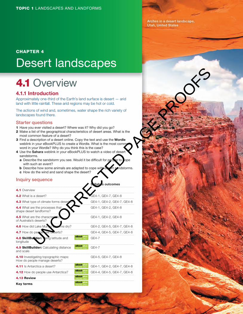
Arches in a desert landscape, Utah, United States
TOPIC 1 LANDSCAPES AND LANDFORMS
CHAPTER 4
Desert landscapes
4.1 Overview 4.1.1 Introduction Approximately one-third of the Earth’s land surface is desert — arid land with little rainfall. These arid regions may be hot or cold.
The actions of wind and, sometimes, water shape the rich variety of landscapes found there.
Starter questions 1 Have you ever visited a desert? Where was it? Why did you go? 2 Make a list of the geographical characteristics of desert areas. What is the
most common feature of a desert? 3 Find a description of a desert online. Copy the text and use the Wordle
weblink in your eBookPLUS to create a Wordle. What is the most common word in your Wordle? Why do you think this is the case?
4 Use the Sahara weblink in your eBookPLUS to watch a video of desert sandstorms. a Describe the sandstorm you see. Would it be diffi cult for people to cope
with such an event? b Describe how some animals are adapted to cope with desert sandstorms. c How do the wind and sand shape the desert?
Inquiry sequence Syllabus outcomes
4.1 Overview
4.2 What is a desert? GE4-1, GE4-7, GE4-8
4.3 What type of climate forms deserts? GE4-1, GE4-2, GE4-7, GE4-8
4.4 What are the processes that shape desert landforms?
GE4-1, GE4-2, GE4-8
4.5 What are the characteristics of Australia’s deserts?
GE4-1, GE4-2, GE4-8
4.6 How did Lake Mungo become dry? GE4-2, GE4-5, GE4-7, GE4-8
4.7 How do people use deserts? GE4-4, GE4-5, GE4-7, GE4-8
4.8 SkillBuilder: Using latitude and longitude
GE4-7
4.9 SkillBuilder: Calculating distance and scale
GE4-7
4.10 Investigating topographic maps: How do people manage deserts?
GE4-5, GE4-7, GE4-8
4.11 Is Antarctica a desert? GE4-1, GE4-2, GE4-7, GE4-8
4.12 How do people use Antarctica? GE4-4, GE4-5, GE4-7, GE4-8
4.13 Review
Key terms
ONLINE ONLY
ONLINE ONLY
ONLINE ONLY
ONLINE ONLY
ONLINE ONLY
ONLINE ONLY
c04DesertLandscapes.indd 72 13/10/16 12:40 pm
UNCORRECTED PAGE P
ROOFS
Watch this videoMajestic mountainsSearchlight ID: eles-1626
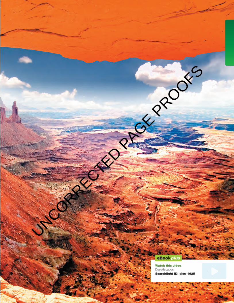
Watch this video Desertscapes Searchlight ID: eles-1625
c04DesertLandscapes.indd 73 13/10/16 12:41 pm
UNCORRECTED PAGE P
ROOFS
74 Geoactive 1 NSW for the Australian Curriculum Stage 4
4.2 What is a desert?4.2.1 Defining a desertA desert is a hot or cold region with little or no rainfall. Around one-third of the Earth’s surface is desert and is home to about 300 million people.
Although they receive little rainfall, most deserts receive some form of precipitation. When it does rain, it is usually during a few heavy storms that last a short time.
TABLE 1 Types of deserts
Rainfall (mm/year) Type of desert Examples
<25 Hyper-arid Namib; Arabian
25–200 Arid Mojave
200–500 Semi-arid Parts of Sonoran Desert
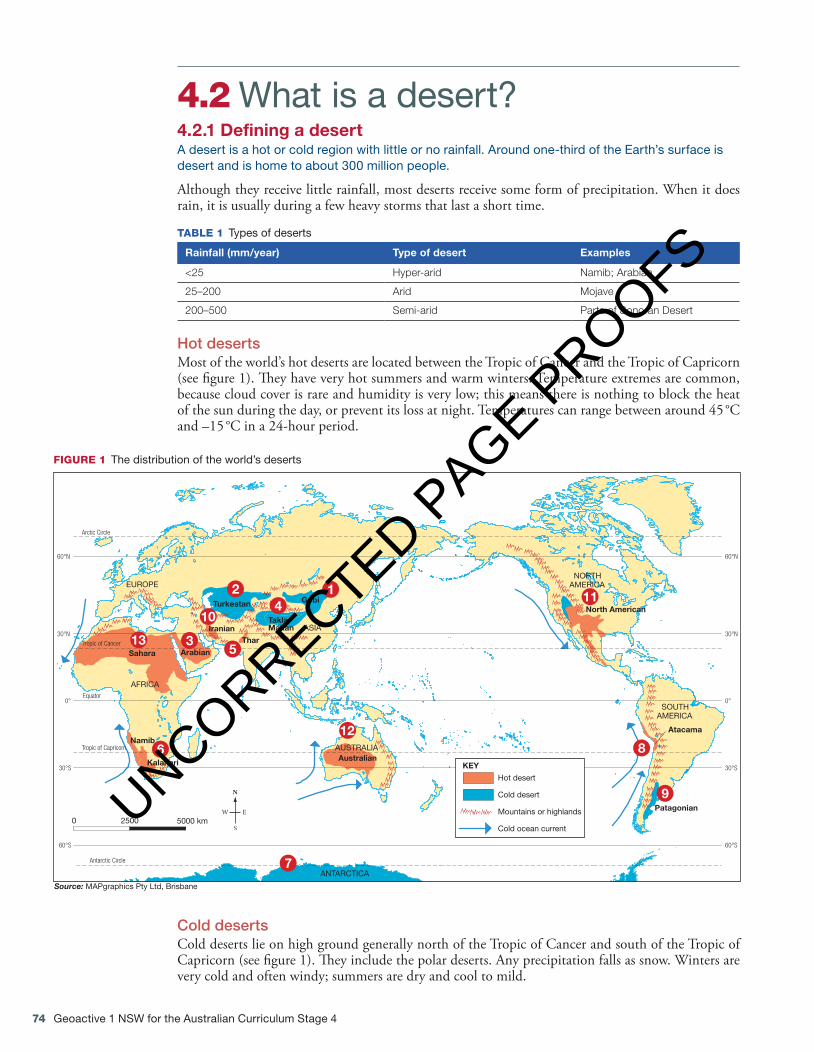
Hot desertsMost of the world’s hot deserts are located between the Tropic of Cancer and the Tropic of Capricorn (see figure 1). They have very hot summers and warm winters. Temperature extremes are common, because cloud cover is rare and humidity is very low; this means there is nothing to block the heat of the sun during the day, or prevent its loss at night. Temperatures can range between around 45 °C and –15 °C in a 24-hour period.
SOUTHAMERICA
NORTHAMERICA
ASIA
EUROPE
AFRICA
ANTARCTICA
AUSTRALIA
Arabian
Gobi
Atacama
Kalahari
Thar
North American
Patagonian
Sahara
Namib
TaklaMakan
Turkestan
Iranian
Australian30°S
60°S
60°N
30°N
0°
30°S
60°S
60°N
30°N
0°
Tropic of Cancer
Equator
Tropic of Capricorn
Arctic Circle
Antarctic Circle
Cold desert
Hot desert
KEY
Cold ocean current
Mountains or highlands0 2500 5000 km
Source: MAPgraphics Pty Ltd, Brisbane
FIGURE 1 The distribution of the world’s deserts
Cold desertsCold deserts lie on high ground generally north of the Tropic of Cancer and south of the Tropic of Capricorn (see figure 1). They include the polar deserts. Any precipitation falls as snow. Winters are very cold and often windy; summers are dry and cool to mild.
10
12
3
4
5
6
7
8
9
11
12
13
c04DesertLandscapes.indd 74 13/10/16 12:41 pm
UNCORRECTED PAGE P
ROOFS
Chapter 4 Desert landscapes 75
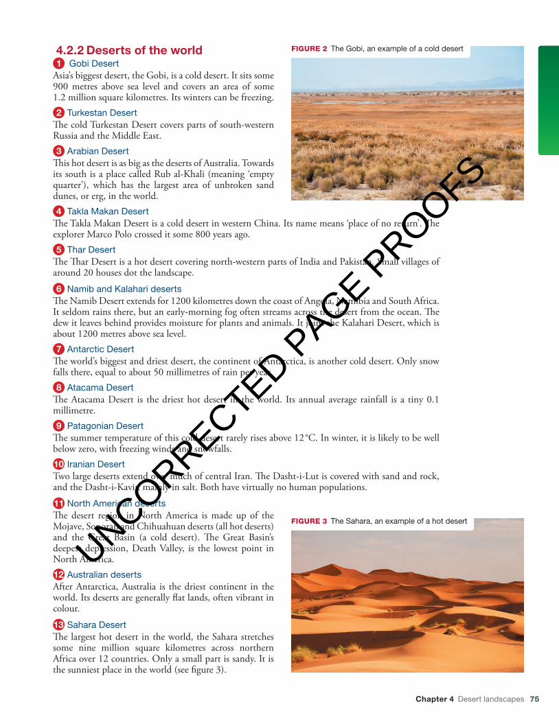
4.2.2 Deserts of the world1 Gobi Desert
Asia’s biggest desert, the Gobi, is a cold desert. It sits some 900 metres above sea level and covers an area of some 1.2 million square kilometres. Its winters can be freezing.2 Turkestan Desert
The cold Turkestan Desert covers parts of south-western Russia and the Middle East.3 Arabian Desert
This hot desert is as big as the deserts of Australia. Towards its south is a place called Rub al-Khali (meaning ‘empty quarter’), which has the largest area of unbroken sand dunes, or erg, in the world.4 Takla Makan Desert
The Takla Makan Desert is a cold desert in western China. Its name means ‘place of no return’. The explorer Marco Polo crossed it some 800 years ago.5 Thar Desert
The Thar Desert is a hot desert covering north-western parts of India and Pakistan. Small villages of around 20 houses dot the landscape.
6 Namib and Kalahari desertsThe Namib Desert extends for 1200 kilometres down the coast of Angola, Namibia and South Africa. It seldom rains there, but an early-morning fog often streams across the desert from the ocean. The dew it leaves behind provides moisture for plants and animals. It joins the Kalahari Desert, which is about 1200 metres above sea level.7 Antarctic Desert
The world’s biggest and driest desert, the continent of Antarctica, is another cold desert. Only snow falls there, equal to about 50 millimetres of rain per year.8 Atacama Desert
The Atacama Desert is the driest hot desert in the world. Its annual average rainfall is a tiny 0.1 millimetre.9 Patagonian Desert
The summer temperature of this cold desert rarely rises above 12 °C. In winter, it is likely to be well below zero, with freezing winds and snowfalls.10 Iranian DesertTwo large deserts extend over much of central Iran. The Dasht-i-Lut is covered with sand and rock, and the Dasht-i-Kavir, mainly in salt. Both have virtually no human populations.
11 North American desertsThe desert region in North America is made up of the Mojave, Sonoran and Chihuahuan deserts (all hot deserts) and the Great Basin (a cold desert). The Great Basin’s deepest depression, Death Valley, is the lowest point in North America.12 Australian desertsAfter Antarctica, Australia is the driest continent in the world. Its deserts are generally flat lands, often vibrant in colour.
13 Sahara DesertThe largest hot desert in the world, the Sahara stretches some nine million square kilometres across northern Africa over 12 countries. Only a small part is sandy. It is the sunniest place in the world (see figure 3).
FIGURE 2 The Gobi, an example of a cold desert
FIGURE 3 The Sahara, an example of a hot desert
c04DesertLandscapes.indd 75 13/10/16 12:42 pm
UNCORRECTED PAGE P
ROOFS

76 Geoactive 1 NSW for the Australian Curriculum Stage 4
IDENTIFY1 What climate conditions are needed for hot and
cold deserts to form?2 Where is the sunniest place in the world?3 Name three deserts in the Asia–Pacific
region.
EXPLAIN4 Describe key differences between hot and cold
deserts.
INVESTIGATE5 Look carefully at the map in figure 1, and the
text.a Which continent has the largest area of hot
desert?b Which continent has the largest area of cold
desert?
c What is the largest hot desert in the world?d What is the largest hot desert in the Asia–
Pacific region?e Which is the driest continent in the world?f Which continent contains the driest hot
desert?g Which North American desert contains the
lowest land on the continent?
APPLY6 Use the information in this section to design
a quiz of 10 questions entitled ‘Deserts of the world’. Test your friends and family.
7 Draw up and complete a table like the one below to show your understanding of the locations and features of desert environments. Look for photos on the internet.
Name of desert Mountain range Continent Ocean current Photos
ACTIVITIES
InteractivityGreat deserts of the worldUse this interactivity to check your knowledge of some of the main hot and cold deserts of the worldSearchlight ID: int-3106
Digital documentScaffolded worksheet 4.1Searchlight ID: doc-18677
4.3 What type of climate forms deserts?4.3.1 The subtropicsDeserts form in many different parts of the globe: the subtropics; continental interior areas at middle latitudes; on the leeward side of mountain ranges; along coastal areas; and in the polar regions. The only common factor is their low rainfall — but why do these areas experience low rainfall?
Most of the world’s greatest deserts are found in the subtropics near the Tropics of Cancer and Capricorn.
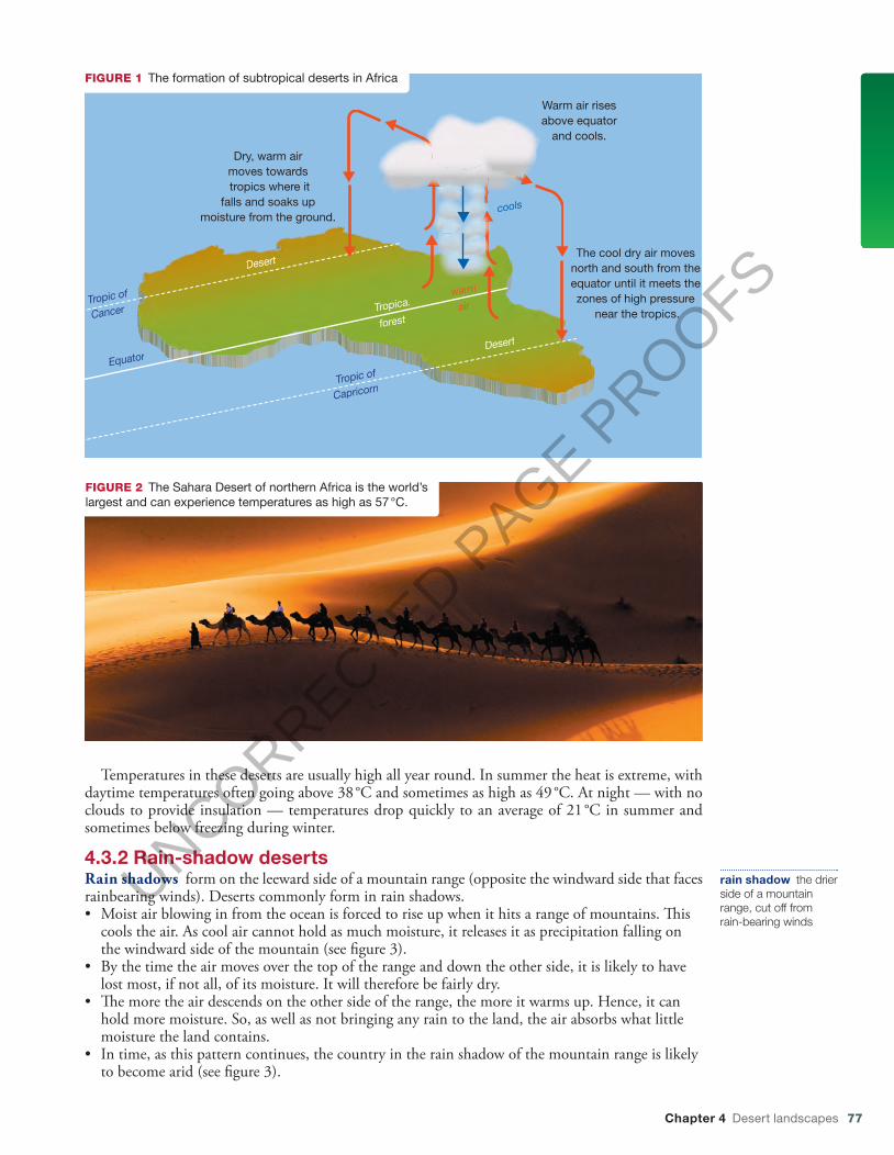
Because of the way the Earth rotates around the sun, areas around the equator receive more direct sunlight than anywhere else on Earth. This means the air there is always very hot. Hot air can hold much more moisture than cold air, so the humidity in these areas is always very high. Hot air also rises. As the air heads upwards into the atmosphere above the equator, it drifts away, heading north and south.
The higher the air gets, the cooler it becomes. Cool air can’t hold as much moisture, so it releases it as rain. Areas around the equator and to the immediate north and south of it (the tropics) receive frequent heavy downpours (see figure 1).
With its moisture gone, the cool, dry air continues moving north and south away from the equator until it meets zones of high air pressure around the tropics. Here, it is forced downwards. The more the dry air descends, the warmer it gets. This means it can hold more moisture and it is likely to absorb any moisture that already exists in this environment. It is like using a sponge to wipe up some water on the kitchen bench; a dry sponge will absorb more of the spill than a wet sponge. This is how the subtropical deserts form.
humidity the amount of water vapour in the atmosphere
c04DesertLandscapes.indd 76 13/10/16 12:42 pm
UNCORRECTED PAGE P
ROOFS
Chapter 4 Desert landscapes 77
Temperatures in these deserts are usually high all year round. In summer the heat is extreme, with daytime temperatures often going above 38 °C and sometimes as high as 49 °C. At night — with no clouds to provide insulation — temperatures drop quickly to an average of 21 °C in summer and sometimes below freezing during winter.
4.3.2 Rain-shadow deserts Rain shadows form on the leeward side of a mountain range (opposite the windward side that faces rainbearing winds). Deserts commonly form in rain shadows. • Moist air blowing in from the ocean is forced to rise up when it hits a range of mountains. � is
cools the air. As cool air cannot hold as much moisture, it releases it as precipitation falling on the windward side of the mountain (see � gure 3 ).
• By the time the air moves over the top of the range and down the other side, it is likely to have lost most, if not all, of its moisture. It will therefore be fairly dry.
• � e more the air descends on the other side of the range, the more it warms up. Hence, it can hold more moisture. So, as well as not bringing any rain to the land, the air absorbs what little moisture the land contains.
• In time, as this pattern continues, the country in the rain shadow of the mountain range is likely to become arid (see � gure 3 ).
rain shadow the drier side of a mountain range, cut off from rain-bearing winds
Dry, warm airmoves towards tropics where it
falls and soaks up moisture from the ground.
Warm air risesabove equator
and cools.
The cool dry air moves north and south from the equator until it meets the zones of high pressure
near the tropics.
FIGURE 1 The formation of subtropical deserts in Africa
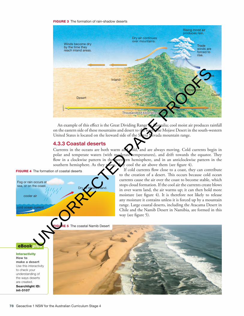
FIGURE 2 The Sahara Desert of northern Africa is the world’s largest and can experience temperatures as high as 57 °C.
c04DesertLandscapes.indd 77 13/10/16 5:28 pm
UNCORRECTED PAGE P
ROOFS
78 Geoactive 1 NSW for the Australian Curriculum Stage 4
An example of this eff ect is the Great Dividing Range in Australia; cool moist air produces rainfall on the eastern side of these mountains and desert to the west. Th e Mojave Desert in the south-western United States is located on the leeward side of the Sierra Nevada mountain range.
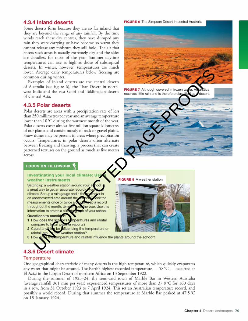
4.3.3 Coastal deserts Currents in the oceans are both warm and cold, and are always moving. Cold currents begin in polar and temperate waters (with moderate temperatures), and drift towards the equator. Th ey fl ow in a clockwise pattern in the northern hemisphere, and in an anticlockwise pattern in the southern hemisphere. As they move, they cool the air above them (see fi gure 4 ).
If cold currents fl ow close to a coast, they can contribute to the creation of a desert. Th is occurs because cold ocean currents cause the air over the coast to become stable, which stops cloud formation. If the cool air the currents create blows in over warm land, the air warms up; it can then hold more moisture (see fi gure 4 ). It is therefore not likely to release any moisture it contains unless it is forced up by a mountain range. Large coastal deserts, including the Atacama Desert in Chile and the Namib Desert in Namibia, are formed in this way (see fi gure 5 ).
Interactivity How to make a desert Use this interactivity to check your understanding of the ways deserts are created. Searchlight ID: int-3107
Winds become dry by the time they reach inland areas.
Rising moist air produces rain.
Trade winds are forced to rise.
Inland
Desert
Mountains
Sea
Coast
Thousands of kilometres
Dry air continues over mountains.
FIGURE 3 The formation of rain-shadow deserts
FIGURE 5 The coastal Namib Desert
Dry air blows inland.
cold ocean current
cooler air
Fog or rain occurs atsea, or on the coast.
FIGURE 4 The formation of coastal deserts
c04DesertLandscapes.indd 78 13/10/16 12:44 pm
UNCORRECTED PAGE P
ROOFS
Chapter 4 Desert landscapes 79
4.3.4 Inland desertsSome deserts form because they are so far inland that they are beyond the range of any rainfall. By the time winds reach these dry centres, they have dumped any rain they were carrying or have become so warm they cannot release any moisture they still hold. The air that enters such areas is usually extremely dry and the skies are cloudless for most of the year. Summer daytime temperatures can rise as high as those of subtropical deserts. In winter, however, temperatures are much lower. Average daily temperatures below freezing are common during winter.
Examples of inland deserts are the central deserts of Australia (see figure 6), the Thar Desert in north-west India and the vast Gobi and Taklimakan deserts of Central Asia.
4.3.5 Polar desertsPolar deserts are areas with a precipitation rate of less than 250 millimetres per year and an average temperature lower than 10 °C during the warmest month of the year. Polar deserts cover almost five million square kilometres of our planet and consist mostly of rock or gravel plains. Snow dunes may be present in areas where precipitation occurs. Temperatures in polar deserts often alternate between freezing and thawing, a process that can create patterned textures on the ground as much as five metres across.
Investigating your local climate: Using weather instrumentsSetting up a weather station around your school is a great way to get an accurate record of your local climate. Set up a rain gauge and a thermometer in an unobstructed area around the school. Check the measurements once or twice a day to keep a record throughout the month, term or even the year. Use this information to create a climate graph of your school.Questions to consider:1 How does the school’s temperatures and rainfall
compare to local weather reports?2 Could anything be influencing the temperature or
rainfall around the weather station?3 How does the temperature and rainfall influence the plants around the school?
FOCUS ON FIELDWORK
FIGURE 8 A weather station
4.3.6 Desert climateTemperatureOne geographical characteristic of many deserts is the high temperature, which quickly evaporates any water that might be around. The Earth’s highest recorded temperature — 58 °C — occurred at El Azizi in the Libyan Desert of northern Africa on 13 September 1922.
During the summer of 1923–24, the semi-arid town of Marble Bar in Western Australia (average rainfall 361 mm per year) experienced temperatures of more than 37.8 °C for 160 days in a row, from 31 October 1923 to 7 April 1924. This set an Australian temperature record, and possibly a world record. During that summer the temperature at Marble Bar peaked at 47.5 °C on 18 January 1924.
FIGURE 6 The Simpson Desert in central Australia
FIGURE 7 Although covered in frozen water, Antarctica receives little rain and is therefore classified as a desert.
c04DesertLandscapes.indd 79 13/10/16 12:45 pm
UNCORRECTED PAGE P
ROOFS
80 Geoactive 1 NSW for the Australian Curriculum Stage 4
RainfallAlthough low rainfall is a characteristic of deserts, rain does fall and violent storms can sometimes occur. A record 44 millimetres of rain once fell within three hours in the Sahara. Large Saharan storms may deliver up to one millimetre of rain per minute. Normally dry stream channels, called arroyos or wadis, can quickly fill after heavy rains, and flash floods make these channels dangerous.
Monthly data for rainfall and temperature can be used to create climographs such as figure 9. Data for other desert locations such as Khormaksar in Yemen and Alice Springs in Australia (see table 1) can be used to construct climographs.
TABLE 1 Climate data for (a) Khormaksar, Yemen, and (b) Alice Springs, Australia
(a) Khormaksar, Yemen
Jan Feb Mar Apr May Jun Jul Aug Sep Oct Nov Dec Total
Average temperature (°C)
25.0 25.5 27.0 28.5 30.5 33.0 32.0 32.0 32.0 28.5 26.5 25.5
Average rainfall (mm)
5.0 0.0 5.0 0.0 0.0 0.0 5.0 3.0 0.0 0.0 0.0 5.0 23.0
(b) Alice Springs, Australia
Jan Feb Mar Apr May Jun Jul Aug Sep Oct Nov Dec Total
Average temperature (°C)
28.5 27.7 24.8 20.0 15.4 12.4 11.5 14.3 18.3 22.8 25.8 27.7
Average rainfall (mm)
40.5 41.5 34.7 16.6 17.0 16.7 12.1 10.0 9.0 20.0 25.3 37.2 281.2
WeblinkDesert rain
InteractivityClimate graph: TimbuktuSearchlight ID: int-0780
0
20
10
30
40
50
0
20
40
60
80
100
DNOSAJJMAMFJ
mm°C
YUMA, ARIZONAAverage monthly
temperature and rainfall
Max.
Min.
FIGURE 9 Temperature and rainfall data can be displayed clearly in a climograph, such as this one for Yuma, Arizona.
IDENTIFY1 Decide whether the following statements are
true or false. Rewrite the false statements to make them true.a The cooler the air, the more moisture it can
hold.b Rain shadows often contain dry areas of land.c Cold ocean currents cool the air above them.d Deserts do not form along coastlines.
EXPLAIN2 Use figure 1 to explain why deserts form
around areas near the tropics but not at the equator. Alternatively, form small groups and create a short drama performance to explain the process.
3 Use figure 3 and any other information in this section to write a paragraph explaining why deserts tend to form in rain shadows. Alternatively, form small groups and create a short drama performance to explain the process.
4 Why do temperatures in deserts drop so much at night after being so high during the day?
INVESTIGATE5 Use the Desert rain weblink in your
eBookPLUS to watch a video about desert rain, and then answer the following questions. a What is a flash flood?b What happens to water as it flows over
sand? Think of what happens to water at the beach.
c How do animals and plants respond to these rare water events?
d Describe how the landscape quickly changes once there is water in the desert.
APPLY6 Draw a diagram to explain how cold ocean
currents influence the formation of a desert environment along the south-west African coastline.
7 Complete the Climate graph: Timbuktu interactivity in your eBookPLUS, and then use tables 1a and 1b to draw climate graphs for Khormaksar, Yemen, and Alice Springs, Australia.
ACTIVITIES
c04DesertLandscapes.indd 80 13/10/16 12:45 pm
UNCORRECTED PAGE P
ROOFS
Chapter 4 Desert landscapes 81
4.4 What are the processes that shape desert landforms? 4.4.1 Shaping the desert Although most people imagine a sea of sand when they think of deserts, sand covers only about 20 per cent of the world’s deserts. Sand is the end product of millions of years of erosion of other landforms such as rock and plateaus that, over time, are worn away by extremes of temperature, wind and water.
Th e landforms and patterns of a desert are created by a number of natural processes. Th e unprotected land surfaces are prone to erosion. After heavy rain, often a long distance from the desert fl ood plains, erosion of ancient river channels can be major. Extreme temperatures, along with strong winds and the rushing water that can follow a desert rainstorm, cause rocks to crack and break down into smaller fragments. Th is process is called weathering .
Erosional landforms Th e process of erosion removes material such as weathered rock. Most erosion in deserts is caused by wind and, at times, running water. During heavy rainfall, water carves channels in the ground. Fast-fl owing water can carry rocks and sand, which help to scour the sides of the channel. As vegetation is usually sparse or non-existent, there are few roots to hold the soil together. Eventually, deep gullies called wadis can form.
Erosion can also result from the action of wind and from chemical reactions. Some rock types, such as limestone, contain compounds that react with rainwater and then dissolve in it. Wind is a very important agent of transport and deposition, and can change the shape of land by abrasion — the wearing down of surfaces by the grinding and sandblasting action of windborne particles. Erosional landforms in deserts include buttes, mesas and inselbergs (see fi gure 7 ).
Depositional landforms Materials carried along by rushing water and wind must eventually be put down. Over time these materials build up, forming diff erent shapes and patterns in the desert. Th is process is called deposition.
Depositional landforms in deserts include alluvial fans, playas, saltpans and various types of sand dunes (see fi gure 7 ).
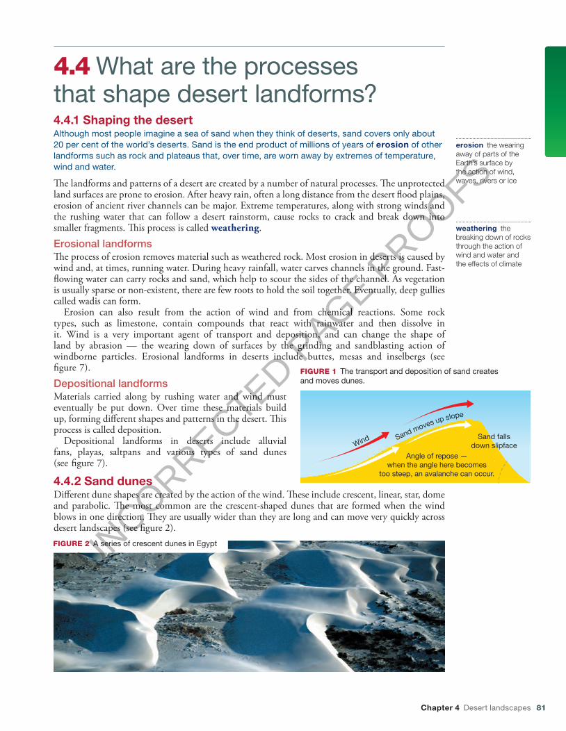
4.4.2 Sand dunes Diff erent dune shapes are created by the action of the wind. Th ese include crescent, linear, star, dome and parabolic. Th e most common are the crescent-shaped dunes that are formed when the wind blows in one direction. Th ey are usually wider than they are long and can move very quickly across desert landscapes (see fi gure 2 ).
erosion the wearing away of parts of the Earth’s surface by the action of wind, waves, rivers or ice
weathering the breaking down of rocks through the action of wind and water and the effects of climate
Wind Sand moves up slope
Angle of repose —when the angle here becomes
too steep, an avalanche can occur.
Sand fallsdown slipface
FIGURE 1 The transport and deposition of sand creates and moves dunes.
FIGURE 2 A series of crescent dunes in Egypt
c04DesertLandscapes.indd 81 13/10/16 12:46 pm
UNCORRECTED PAGE P
ROOFS

82 Geoactive 1 NSW for the Australian Curriculum Stage 4
Linear dunes are a series of dunes running parallel to each other. They can vary in length from a few metres to over 100 kilometres. It appears that winds blowing in opposite directions help create these dunes. The Simpson Desert in central Australia has linear dunes (see figure 3).
Star dunes have ‘arms’ that radiate from a high central pyramid-shaped mound. They form in regions that have winds blowing in many different directions and can become very tall rather than wide — some are up to 500 metres high (see figure 4).
FIGURE 5 A dome dune in the Chihuahuan Desert, North America
FIGURE 4 Star dunes are found in many deserts including the Namib, the Grand Erg Oriental of the Sahara, and the southeast Badain Jaran Desert of China.
Dome dunes are made up of fine sand without a steep side. These rounded structures tend to be only one or two metres high and are very rare (see figure 5).
FIGURE 3 Linear sand dunes in the Simpson Desert, Australia
c04DesertLandscapes.indd 82 13/10/16 5:31 pm
UNCORRECTED PAGE P
ROOFS

Chapter 4 Desert landscapes 83
Parabolic dunes have a U shape and do not get very high. Th ey often occur in coastal deserts. Th e longer section follows the ‘head’ of the dune (the opposite process to the formation of crescent dunes) because vegetation has anchored them in place. Th e arms can be long — in one case, measured at 12 kilometres (see fi gure 6 ).
4.4.3 Desert landforms
Wind
FIGURE 6 Formation of a parabolic dune
1
9
5
13
3
11
7
2
10
6 14
4
12
8
FIGURE 7 Desert landforms
1 A butte is the remaining solid core of what was once a mesa. It often is shaped like a castle or a tower.
2 Crescent-shaped barchan dunes are produced when sand cover is fairly light.
3 An arch, or window, is an opening in a rocky wall that has been carved out over millions of years by erosion.
4 An alluvial fan is the semicircular build-up of material that collects at the base of slopes and at the end of wadis after being deposited there by water and wind.
5 A playa lake may cover a wide area, but it is never deep. Most water in it evaporates, leaving a layer of salt on the surface. These salt-covered stretches are called saltpans.
6 Clay pans are low-lying sections of ground that may remain wet and muddy for some time. 7 The rippled surface on transverse dunes is the result of a gentle breeze blowing in the one direction. 8 An oasis is a fertile spot in a desert. It receives water from underground supplies. 9 A mesa is a plateau-like section of higher land with a fl at top and steep sides. The fl at surface was once the
ground level, before weathering and erosion took their toll. 10 Sand dunes often start as small mounds of sand that collect around an object such as a rock. As they grow
larger, they are moved and shaped by wind. 11 An inselberg is a solid rock formation that was once below ground level. As the softer land around it erodes, it
becomes more and more prominent. Uluru is an inselberg. 12 A chimney rock is the pillar-like remains of a butte. 13 Star dunes are produced by wind gusts that swirl in from all directions.
14 Strong winds blowing in one direction form longitudinal dunes.
Playas and pans A desert basin may fi ll with water after heavy rains to form a shallow lake, but for the majority of the time the often salt-encrusted surface is hard and dry. Such expanses of land are known as playas, saltpans or hardpans. Th e fl at terrains of pans and playas make them excellent race tracks
c04DesertLandscapes.indd 83 13/10/16 12:47 pm
UNCORRECTED PAGE P
ROOFS

84 Geoactive 1 NSW for the Australian Curriculum Stage 4
and natural runways for aeroplanes and spacecraft. Ground-vehicle speed records are commonly established on Bonneville Speedway, a race track on the Great Salt Lake hardpan. Space shuttles land on Rogers Lake Playa at Edwards Air Force Base, California.
FIGURE 8 A driver lying in a streamlined racing car, Bonneville Salt Flats, Utah, USA
InteractivityFact finder: Desert LandformsSearchlight ID: int-0778
IDENTIFY1 List the agents of erosion and weathering in a
desert.2 Name two erosional and two depositional
landforms in a desert.3 Name the most common dune shapes that are
formed in deserts.
EXPLAIN4 Explain the difference between a mesa and a
butte.5 How does vegetation help to prevent erosion
in a desert?6 What wind conditions are needed to
create a:a star duneb longitudinal dunec parallel dune?
7 Why do you think oases are such fertile places?
8 What do chimney rocks and arches have in common?
9 What do playa lakes and saltpans have in common?
10 Draw up and complete a table like the one below for the three landforms listed.
Continue to add the landforms shown in figure 7 to your table. Add examples of other
Name of landform Picture of landform LocationType of erosion (wind or water)
Type of deposition (wind or water)
Butte
Mesa
Inselberg
desert landforms that you have found when researching this topic.
INVESTIGATE11 Locate all the desert places named in this
section. Use Google Maps to create your own world map of these locations, adding interesting facts and some images of each location. Email a link to your completed map to your teacher.
PREDICT12 Study the landforms labelled 1, 3 and 9 in
figure 7. Sketch what each of these may look like in the future as erosion and weathering continue to occur.
APPLY13 Work in small groups to create a model of
a desert (using plasticine or playdoh, for example) that contains a number of desert forms and patterns. Use figure 7 as a guide. Show your completed model to the other groups, providing and responding to constructive feedback.
14 Complete the Fact finder: ‘Desert landforms’ interactivity (int-0778) in your eBookPLUS.
ACTIVITIES
c04DesertLandscapes.indd 84 13/10/16 12:47 pm
UNCORRECTED PAGE P
ROOFS
Chapter 4 Desert landscapes 85
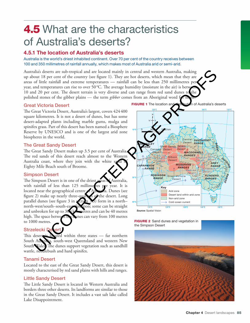
4.5 What are the characteristics of Australia’s deserts?4.5.1 The location of Australia’s desertsAustralia is the world’s driest inhabited continent. Over 70 per cent of the country receives between 100 and 350 millimetres of rainfall annually, which makes most of Australia arid or semi-arid.
Australia’s deserts are sub-tropical and are located mainly in central and western Australia, making up about 18 per cent of the country (see figure 1). They are hot deserts, which mean that they are areas of little rainfall and extreme temperatures — rainfall can be less than 250 millimetres per year, and temperatures can rise to over 50 oC. The average humidity (moisture in the air) is between 10 and 20 per cent. The desert terrain is very diverse and can range from red sand dunes to the polished stones of the gibber plains — the term gibber comes from an Aboriginal word for stone.
Great Victoria DesertThe Great Victoria Desert, Australia’s largest, covers 424 400 square kilometres. It is not a desert of dunes, but has some desert-adapted plants including marble gums, mulga and spinifex grass. Part of this desert has been named a Biosphere Reserve by UNESCO and is one of the largest arid zone biospheres in the world.
The Great Sandy DesertThe Great Sandy Desert makes up 3.5 per cent of Australia. The red sands of this desert reach almost to the Western Australia coast, where they join with the white sand of Eighty Mile Beach south of Broome.
Simpson DesertThe Simpson Desert is in one of the driest areas of Australia, with rainfall of less than 125 millimetres per year. It is located near the geographical centre of Australia. Dunes (see figure 2) make up nearly three-quarters of the desert. Long parallel dunes (see figure 3 in section 3.3) form in a north–north-west/south–south-east direction; some can be straight and unbroken for up to 300 kilometres and can be 40 metres high. The space between the dunes can vary from 100 metres to 1000 metres.
Strzelecki DesertThis desert is located within three states — far northern South Australia, south-west Queensland and western New South Wales. The dunes support vegetation such as sandhill wattle, needlebush and hard spinifex.
Tanami DesertLocated to the east of the Great Sandy Desert, this desert is mostly characterised by red sand plains with hills and ranges.
Little Sandy DesertThe Little Sandy Desert is located in Western Australia and borders three other deserts. Its landforms are similar to those in the Great Sandy Desert. It includes a vast salt lake called Lake Disappointment.
FIGURE 2 Sand dunes and vegetation in the Simpson Desert
110°E 120°E 130°E 140°E 150°E
150°E120°E 130°E 140°E
40°S
30°S
20°S
10°S
Tropic of Capricorn
MACDONNELLRANGES
HAMERSLEYRANGE
CARNARVONRANGE
GR
EA
T
DIVIDIN
GR
AN
GE
FLINDERSRANGES
ROBINSONRANGE
GREY RANGE
DAVENPORTRANGE
MUSGRAVERANGES
CentralDesert
SimpsonDesert
StrzeleckiDesert
Great Victor iaDesert
GibsonDesert
Li t t leSandyDesert
CanningDesert
Great SandyDesert
TanamiDesert
Pedirka Desert
SturtStonyDesert
Tirar iDesert
KeyArid zone
Desert land within arid zone
Non-arid zone
Cold ocean current
0 500 1000 km
Source: Spatial Vision
FIGURE 1 The location and distribution of Australia’s deserts
c04DesertLandscapes.indd 85 13/10/16 12:48 pm
UNCORRECTED PAGE P
ROOFS
86 Geoactive 1 NSW for the Australian Curriculum Stage 4
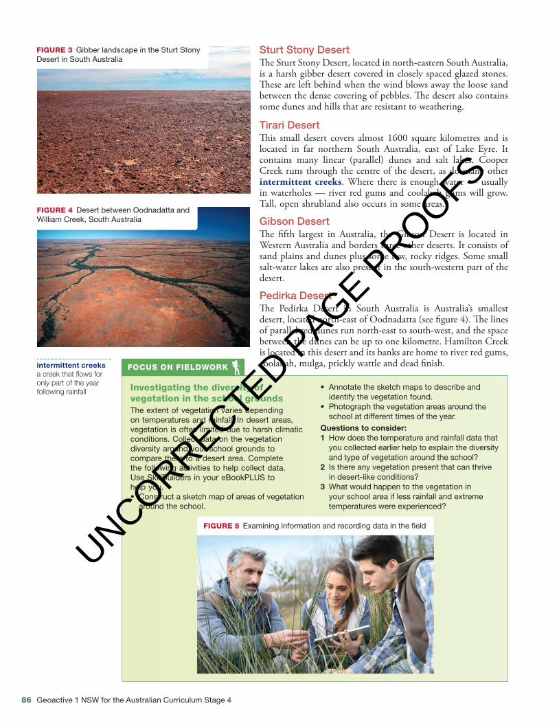
Sturt Stony DesertThe Sturt Stony Desert, located in north-eastern South Australia, is a harsh gibber desert covered in closely spaced glazed stones. These are left behind when the wind blows away the loose sand between the dense covering of pebbles. The desert also contains some dunes and hills that are resistant to weathering.
Tirari DesertThis small desert covers almost 1600 square kilometres and is located in far northern South Australia, east of Lake Eyre. It contains many linear (parallel) dunes and salt lakes. Cooper Creek runs through the centre of the desert, as do many other intermittent creeks. Where there is enough water — usually in waterholes — river red gums and coolabah gums will grow. Tall, open shrubland also occurs in some areas.
Gibson DesertThe fifth largest in Australia, the Gibson Desert is located in Western Australia and borders three other deserts. It consists of sand plains and dunes plus some low, rocky ridges. Some small salt-water lakes are also present in the south-western part of the desert.
Pedirka DesertThe Pedirka Desert in South Australia is Australia’s smallest desert, located north-east of Oodnadatta (see figure 4). The lines of parallel red dunes run north-east to south-west, and the space between the dunes can be up to one kilometre. Hamilton Creek is located in this desert and its banks are home to river red gums, coolabah, mulga, prickly wattle and dead finish.intermittent creeks
a creek that flows for only part of the year following rainfall
FIGURE 3 Gibber landscape in the Sturt Stony Desert in South Australia
FIGURE 4 Desert between Oodnadatta and William Creek, South Australia
Investigating the diversity of vegetation in the school groundsThe extent of vegetation varies depending on temperatures and rainfall. In desert areas, vegetation is often limited due to harsh climatic conditions. Collect data on the vegetation diversity around your school grounds to compare them to a desert area. Complete the following activities to help collect data. Use SkillBuilders in your eBookPLUS to help you.• Construct a sketch map of areas of vegetation
around the school.
• Annotate the sketch maps to describe and identify the vegetation found.
• Photograph the vegetation areas around the school at different times of the year.
Questions to consider:1 How does the temperature and rainfall data that
you collected earlier help to explain the diversity and type of vegetation around the school?
2 Is there any vegetation present that can thrive in desert-like conditions?
3 What would happen to the vegetation in your school area if less rainfall and extreme temperatures were experienced?
FOCUS ON FIELDWORK
FIGURE 5 Examining information and recording data in the field
c04DesertLandscapes.indd 86 13/10/16 12:49 pm
UNCORRECTED PAGE P
ROOFS
Chapter 4 Desert landscapes 87
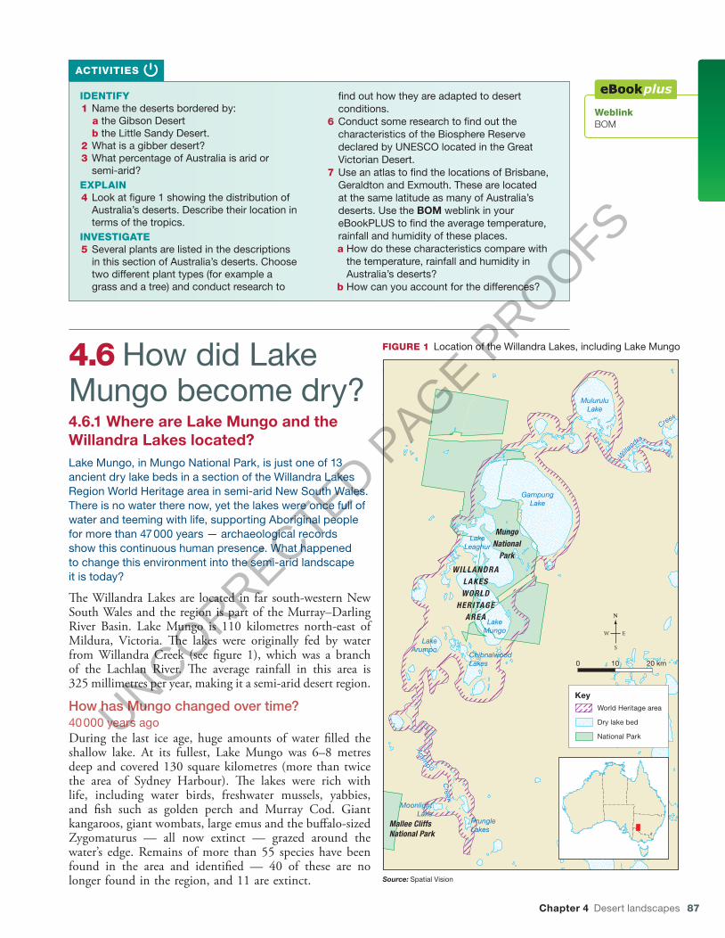
4.6 How did Lake Mungo become dry?4.6.1 Where are Lake Mungo and the Willandra Lakes located?Lake Mungo, in Mungo National Park, is just one of 13 ancient dry lake beds in a section of the Willandra Lakes Region World Heritage area in semi-arid New South Wales. There is no water there now, yet the lakes were once full of water and teeming with life, supporting Aboriginal people for more than 47 000 years — archaeological records show this continuous human presence. What happened to change this environment into the semi-arid landscape it is today?
The Willandra Lakes are located in far south-western New South Wales and the region is part of the Murray–Darling River Basin. Lake Mungo is 110 kilometres north-east of Mildura, Victoria. The lakes were originally fed by water from Willandra Creek (see figure 1), which was a branch of the Lachlan River. The average rainfall in this area is 325 millimetres per year, making it a semi-arid desert region.
How has Mungo changed over time?40 000 years agoDuring the last ice age, huge amounts of water filled the shallow lake. At its fullest, Lake Mungo was 6–8 metres deep and covered 130 square kilometres (more than twice the area of Sydney Harbour). The lakes were rich with life, including water birds, freshwater mussels, yabbies, and fish such as golden perch and Murray Cod. Giant kangaroos, giant wombats, large emus and the buffalo-sized Zygomaturus — all now extinct — grazed around the water’s edge. Remains of more than 55 species have been found in the area and identified — 40 of these are no longer found in the region, and 11 are extinct.
IDENTIFY1 Name the deserts bordered by:
a the Gibson Desertb the Little Sandy Desert.
2 What is a gibber desert?3 What percentage of Australia is arid or
semi-arid?EXPLAIN4 Look at figure 1 showing the distribution of
Australia’s deserts. Describe their location in terms of the tropics.
INVESTIGATE5 Several plants are listed in the descriptions
in this section of Australia’s deserts. Choose two different plant types (for example a grass and a tree) and conduct research to
find out how they are adapted to desert conditions.
6 Conduct some research to find out the characteristics of the Biosphere Reserve declared by UNESCO located in the Great Victorian Desert.
7 Use an atlas to find the locations of Brisbane, Geraldton and Exmouth. These are located at the same latitude as many of Australia’s deserts. Use the BOM weblink in your eBookPLUS to find the average temperature, rainfall and humidity of these places. a How do these characteristics compare with
the temperature, rainfall and humidity in Australia’s deserts?
b How can you account for the differences?
ACTIVITIES
WeblinkBOM
LakeLeaghur
LakeMungo
GarnpungLake
MuluruluLake
ChibnalwoodLakes
LakeArumpo
MoonlightLake
PrungleLakes
Arum
po
Creek
W
illa
ndra
Creek
MungoNational
Park
Mallee CliffsNational Park
WILLANDRALAKESWORLD
HERITAGEAREA
KeyWorld Heritage area
Dry lake bed
National Park
0 10 20 km
Source: Spatial Vision
FIGURE 1 Location of the Willandra Lakes, including Lake Mungo
c04DesertLandscapes.indd 87 13/10/16 12:49 pm
UNCORRECTED PAGE P
ROOFS
88 Geoactive 1 NSW for the Australian Curriculum Stage 4
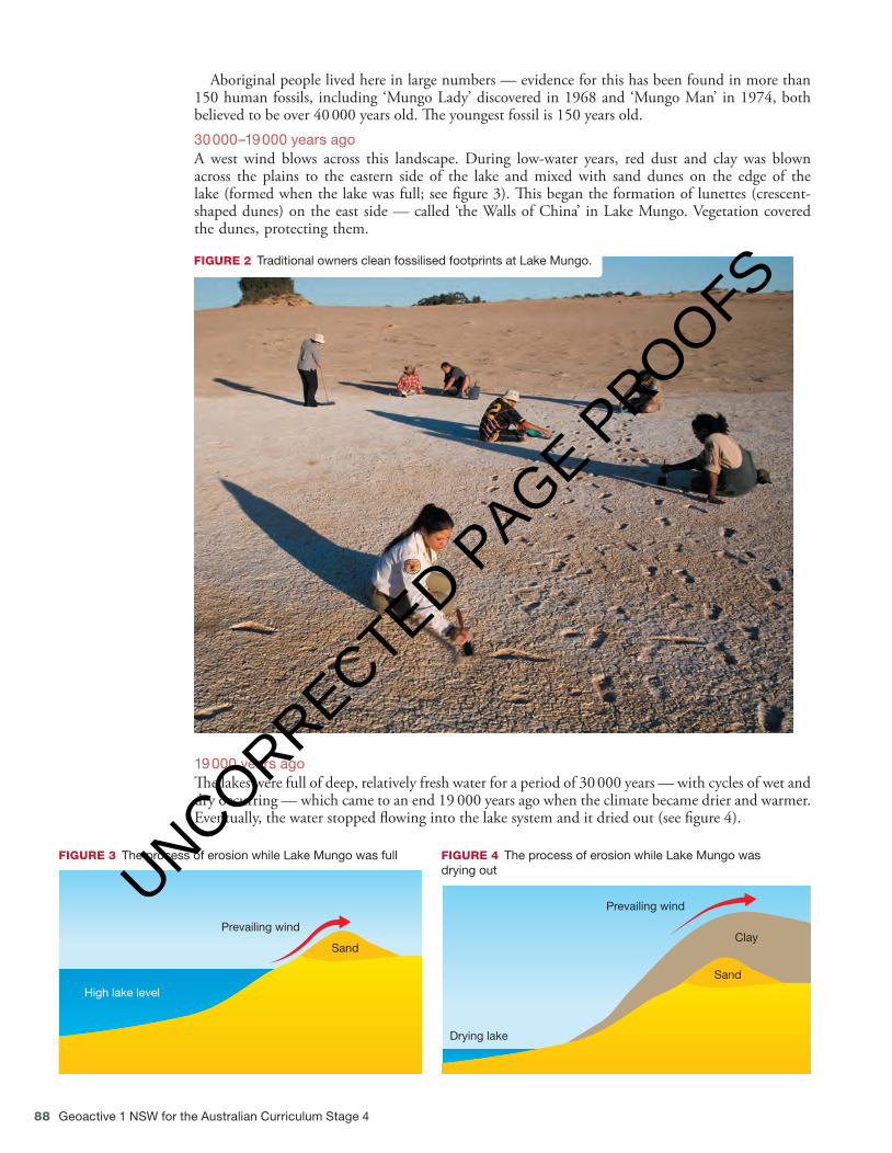
FIGURE 2 Traditional owners clean fossilised footprints at Lake Mungo.
Aboriginal people lived here in large numbers — evidence for this has been found in more than 150 human fossils, including ‘Mungo Lady’ discovered in 1968 and ‘Mungo Man’ in 1974, both believed to be over 40 000 years old. The youngest fossil is 150 years old.30 000–19 000 years agoA west wind blows across this landscape. During low-water years, red dust and clay was blown across the plains to the eastern side of the lake and mixed with sand dunes on the edge of the lake (formed when the lake was full; see figure 3). This began the formation of lunettes (crescent-shaped dunes) on the east side — called ‘the Walls of China’ in Lake Mungo. Vegetation covered the dunes, protecting them.
Prevailing wind
Sand
High lake level
FIGURE 3 The process of erosion while Lake Mungo was full
Prevailing wind
Sand
Clay
Drying lake
FIGURE 4 The process of erosion while Lake Mungo was drying out
19 000 years agoThe lakes were full of deep, relatively fresh water for a period of 30 000 years — with cycles of wet and dry occurring — which came to an end 19 000 years ago when the climate became drier and warmer. Eventually, the water stopped flowing into the lake system and it dried out (see figure 4).
c04DesertLandscapes.indd 88 13/10/16 12:49 pm
UNCORRECTED PAGE P
ROOFS
Chapter 4 Desert landscapes 89
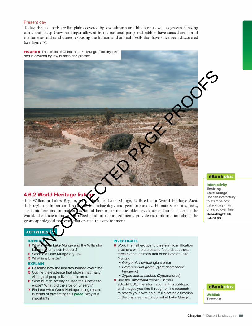
FIGURE 5 The ‘Walls of China’ at Lake Mungo. The dry lake bed is covered by low bushes and grasses.
InteractivityEvolving Lake MungoUse this interactivity to examine how Lake Mungo has changed over time.Searchlight ID: int-3108
IDENTIFY1 What makes Lake Mungo and the Willandra
Lakes region a semi-desert?2 When did Lake Mungo dry up?3 What is a lunette?
EXPLAIN4 Describe how the lunettes formed over time.5 Outline the evidence that shows that many
Aboriginal people lived in this area.6 What human activity caused the lunettes to
erode? What did the erosion unearth?7 Find out what World Heritage listing means
in terms of protecting this place. Why is it important?
INVESTIGATE8 Work in small groups to create an identification
brochure with pictures and facts about these three extinct animals that once lived at Lake Mungo.• Genyornis newtoni (giant emu)• Protemnodon goliah (giant short-faced
kangaroo)• Zygomaturus trilobus (Zygomaturus)
9 Use the Timetoast weblink in your eBookPLUS, the information in this subtopic and images you find through online research to create your own colourful electronic timeline of the changes that occurred at Lake Mungo.
ACTIVITIES
4.6.2 World Heritage listingThe Willandra Lakes Region, which includes Lake Mungo, is listed as a World Heritage Area. This region is important because of its archaeology and geomorphology. Human skeletons, tools, shell middens and animal bones found here make up the oldest evidence of burial places in the world. The ancient and undisturbed landforms and sediments provide rich information about the geomorphological processes that created this environment.
Present dayToday, the lake beds are flat plains covered by low saltbush and bluebush as well as grasses. Grazing cattle and sheep (now no longer allowed in the national park) and rabbits have caused erosion of the lunettes and sand dunes, exposing the human and animal fossils that have since been discovered (see figure 5).
WeblinkTimetoast
c04DesertLandscapes.indd 89 13/10/16 12:49 pm
UNCORRECTED PAGE P
ROOFS
90 Geoactive 1 NSW for the Australian Curriculum Stage 4
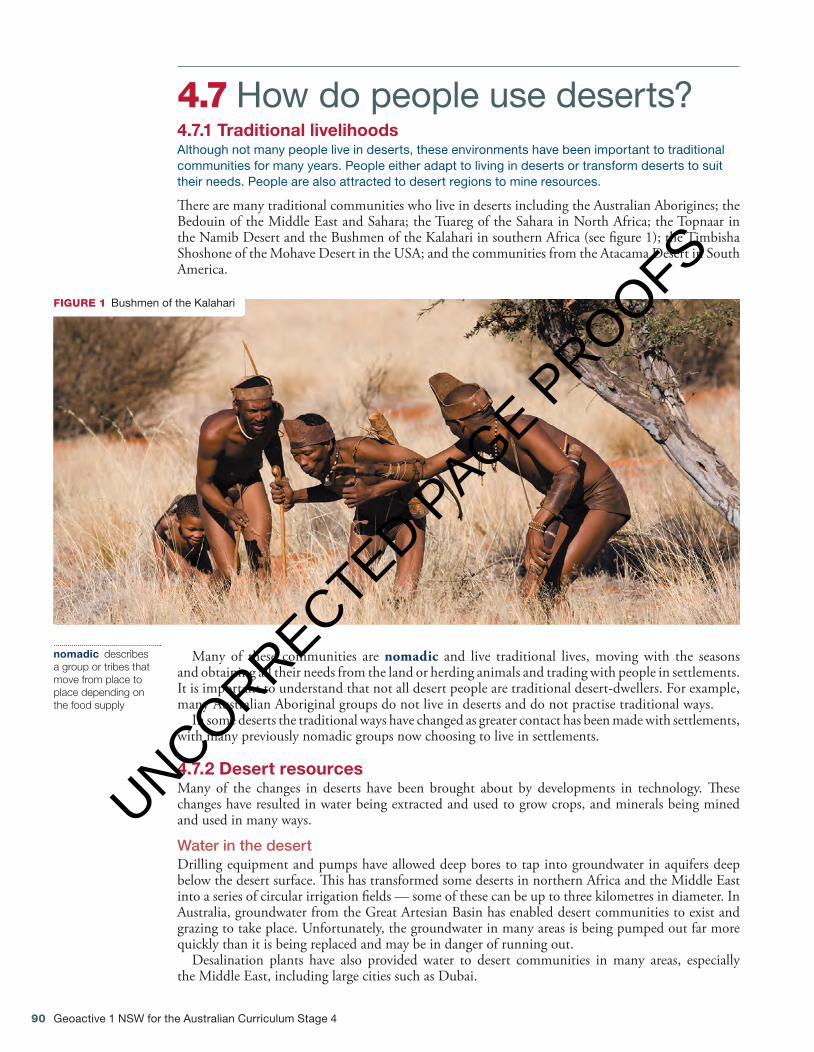
FIGURE 1 Bushmen of the Kalahari
Many of these communities are nomadic and live traditional lives, moving with the seasons and obtaining all their needs from the land or herding animals and trading with people in settlements. It is important to understand that not all desert people are traditional desert-dwellers. For example, many Australian Aboriginal groups do not live in deserts and do not practise traditional ways.
In some deserts the traditional ways have changed as greater contact has been made with settlements, with many previously nomadic groups now choosing to live in settlements.
4.7.2 Desert resourcesMany of the changes in deserts have been brought about by developments in technology. These changes have resulted in water being extracted and used to grow crops, and minerals being mined and used in many ways.
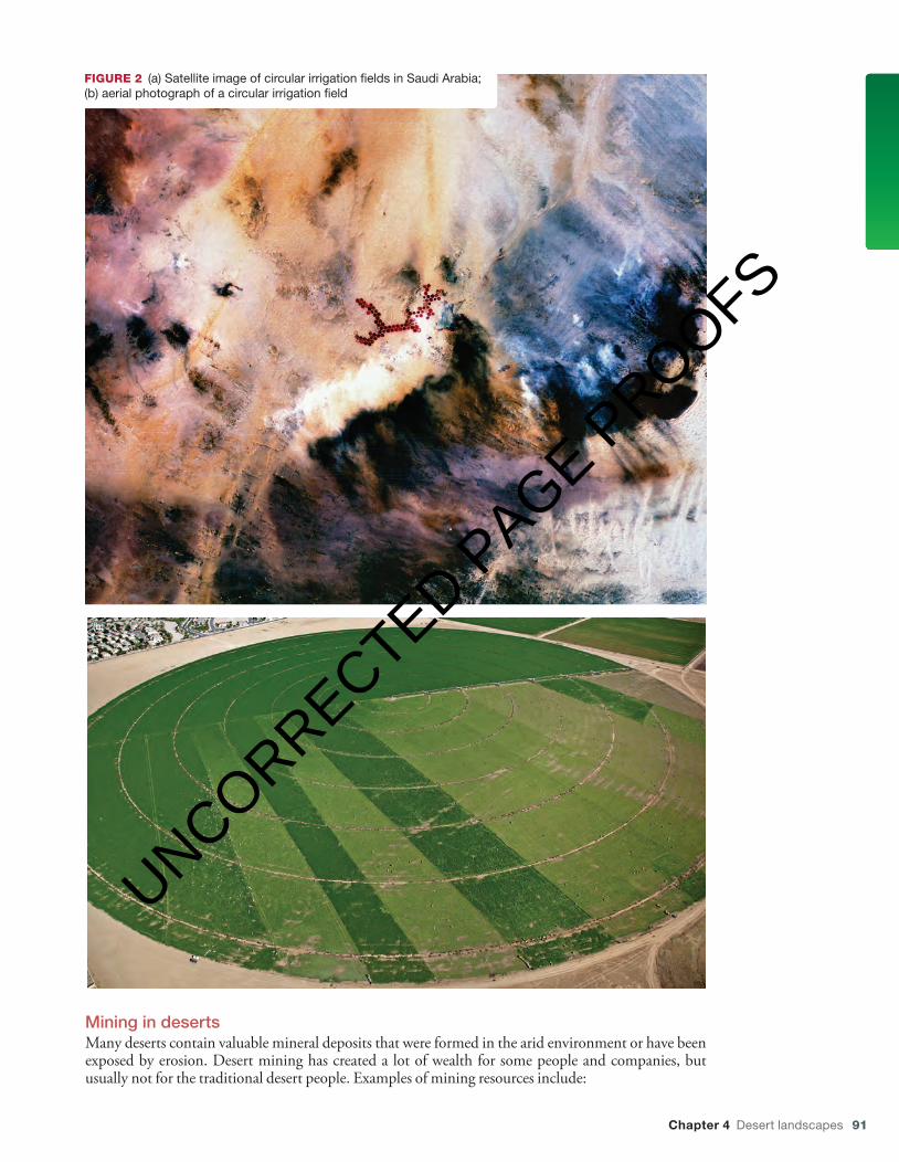
Water in the desertDrilling equipment and pumps have allowed deep bores to tap into groundwater in aquifers deep below the desert surface. This has transformed some deserts in northern Africa and the Middle East into a series of circular irrigation fields — some of these can be up to three kilometres in diameter. In Australia, groundwater from the Great Artesian Basin has enabled desert communities to exist and grazing to take place. Unfortunately, the groundwater in many areas is being pumped out far more quickly than it is being replaced and may be in danger of running out.
Desalination plants have also provided water to desert communities in many areas, especially the Middle East, including large cities such as Dubai.
nomadic describes a group or tribes that move from place to place depending on the food supply
4.7 How do people use deserts?4.7.1 Traditional livelihoodsAlthough not many people live in deserts, these environments have been important to traditional communities for many years. People either adapt to living in deserts or transform deserts to suit their needs. People are also attracted to desert regions to mine resources.
There are many traditional communities who live in deserts including the Australian Aborigines; the Bedouin of the Middle East and Sahara; the Tuareg of the Sahara in North Africa; the Topnaar in the Namib Desert and the Bushmen of the Kalahari in southern Africa (see figure 1); the Timbisha Shoshone of the Mohave Desert in the USA; and the communities from the Atacama Desert in South America.
c04DesertLandscapes.indd 90 13/10/16 12:50 pm
UNCORRECTED PAGE P
ROOFS
Chapter 4 Desert landscapes 91
FIGURE 2 (a) Satellite image of circular irrigation fields in Saudi Arabia; (b) aerial photograph of a circular irrigation field
(b)
Mining in desertsMany deserts contain valuable mineral deposits that were formed in the arid environment or have been exposed by erosion. Desert mining has created a lot of wealth for some people and companies, but usually not for the traditional desert people. Examples of mining resources include:
c04DesertLandscapes.indd 91 13/10/16 12:51 pm
UNCORRECTED PAGE P
ROOFS
92 Geoactive 1 NSW for the Australian Curriculum Stage 4
• iron and lead-zinc ore — mined in Australian deserts• phosphorus (used to make fertilisers) — mined in the Sahara region• borates (used to manufacture glass, ceramics, enamels and agricultural chemicals) mined in the
deserts of California, United States• copper, iron ore and nitrates — mined in Chile’s Atacama Desert• precious metals such as gold, silver and platinum — mined in the deserts of Australia, America
and central Asia• uranium — mined in Australia and the United States• diamonds — mined in the Kalahari and Namib deserts of south-western Africa• oil — more than 65 per cent of the world’s oil is found in the desert regions of the Middle East,
mainly in Kuwait, Iraq, Iran and Saudi Arabia.
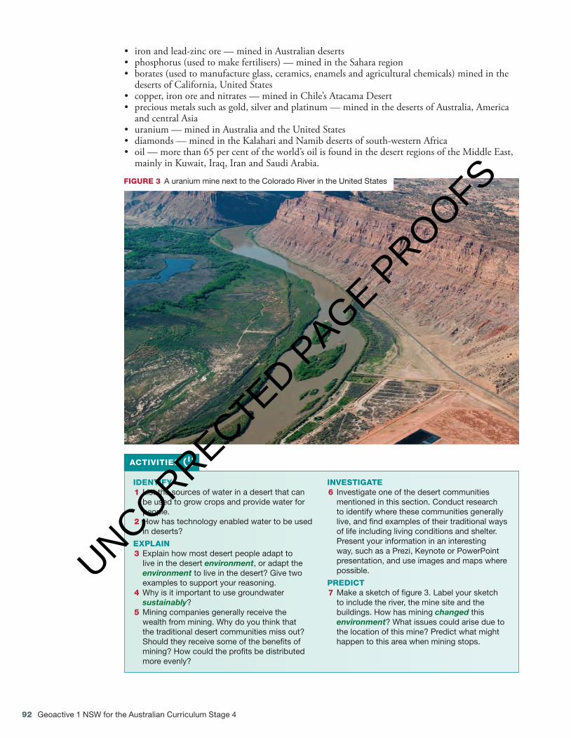
FIGURE 3 A uranium mine next to the Colorado River in the United States
IDENTIFY1 List the sources of water in a desert that can
be used to grow crops and provide water for people.
2 How has technology enabled water to be used in deserts?
EXPLAIN3 Explain how most desert people adapt to
live in the desert environment, or adapt the environment to live in the desert? Give two examples to support your reasoning.
4 Why is it important to use groundwater sustainably?
5 Mining companies generally receive the wealth from mining. Why do you think that the traditional desert communities miss out? Should they receive some of the benefits of mining? How could the profits be distributed more evenly?
INVESTIGATE6 Investigate one of the desert communities
mentioned in this section. Conduct research to identify where these communities generally live, and find examples of their traditional ways of life including living conditions and shelter. Present your information in an interesting way, such as a Prezi, Keynote or PowerPoint presentation, and use images and maps where possible.
PREDICT7 Make a sketch of figure 3. Label your sketch
to include the river, the mine site and the buildings. How has mining changed this environment? What issues could arise due to the location of this mine? Predict what might happen to this area when mining stops.
ACTIVITIES
c04DesertLandscapes.indd 92 13/10/16 12:51 pm
UNCORRECTED PAGE P
ROOFS
Chapter 4 Desert landscapes 93
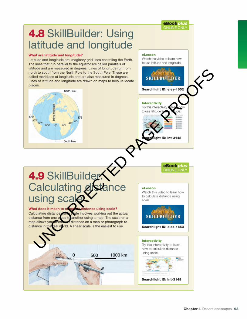
4.8 SkillBuilder: Using latitude and longitudeWhat are latitude and longitude?Latitude and longitude are imaginary grid lines encircling the Earth. The lines that run parallel to the equator are called parallels of latitude and are measured in degrees. Lines of longitude run from north to south from the North Pole to the South Pole. These are called meridians of longitude and are also measured in degrees. Lines of latitude and longitude are drawn on maps to help us locate places.
ONLINE ONLY
eLessonWatch the video to learn how to use latitude and longitude.
Searchlight ID: eles-1652
InteractivityTry this interactivity to learn how to use latitude and longitude.
Searchlight ID: int-3148
4.9 SkillBuilder: Calculating distance using scaleWhat does it mean to calculate distance using scale?Calculating distance using scale involves working out the actual distance from one place to another using a map. The scale on a map allows you to convert distance on a map or photograph to distance in the real world. A linear scale is the easiest to use.
ONLINE ONLY
eLessonWatch this video to learn how to calculate distance using scale.
Searchlight ID: eles-1653
InteractivityTry this interactivity to learn how to calculate distance using scale.
Searchlight ID: int-3149
c04DesertLandscapes.indd 93 13/10/16 12:51 pm
UNCORRECTED PAGE P
ROOFS
94 Geoactive 1 NSW for the Australian Curriculum Stage 4
INVESTIGATING TOPOGRAPHIC MAPS
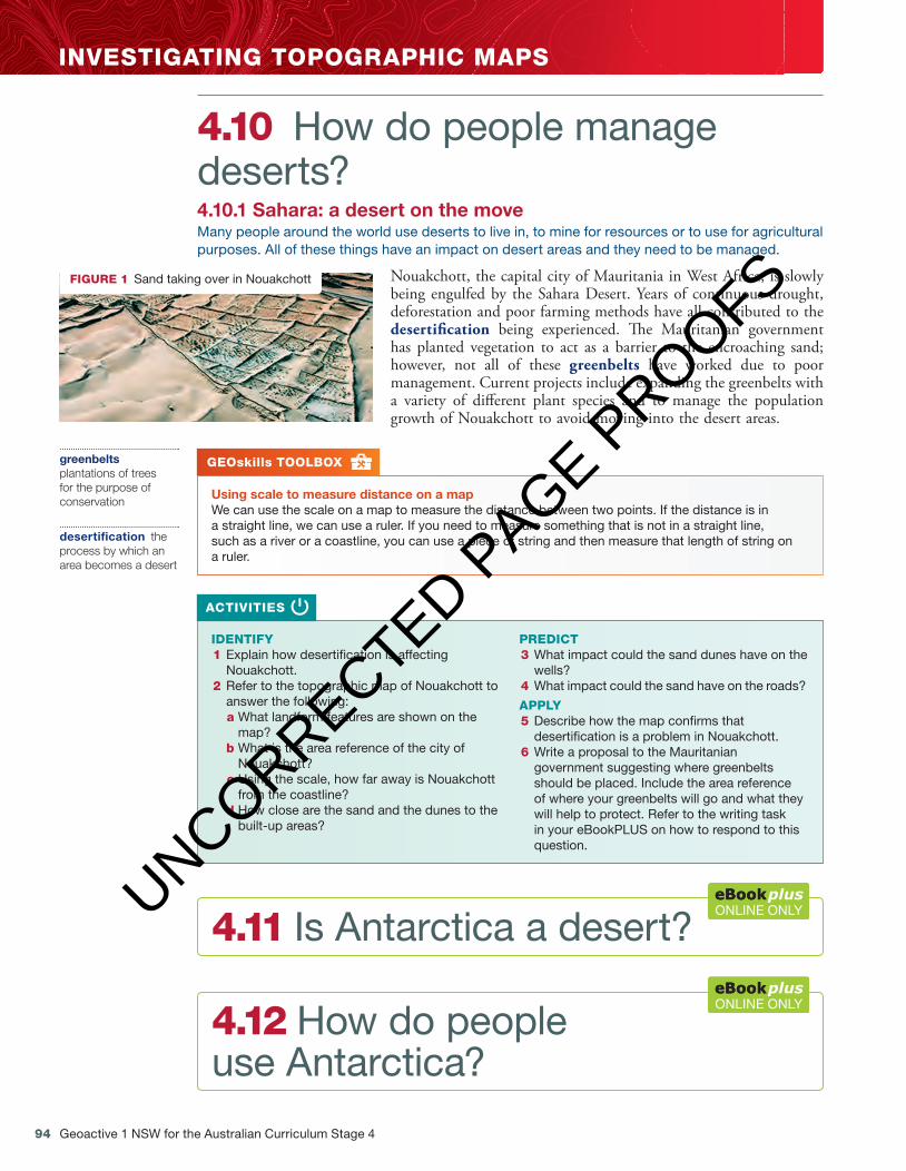
4.10 How do people manage deserts? 4.10.1 Sahara: a desert on the move Many people around the world use deserts to live in, to mine for resources or to use for agricultural purposes. All of these things have an impact on desert areas and they need to be managed.
Nouakchott, the capital city of Mauritania in West Africa, is slowly being engulfed by the Sahara Desert. Years of continuous drought, deforestation and poor farming methods have all contributed to the desertifi cation being experienced. Th e Mauritanian government has planted vegetation to act as a barrier to the encroaching sand; however, not all of these greenbelts have worked due to poor management. Current projects include expanding the greenbelts with a variety of diff erent plant species and to manage the population growth of Nouakchott to avoid moving into the desert areas.
GEOskills TOOLBOX
Using scale to measure distance on a map We can use the scale on a map to measure the distance between two points. If the distance is in a straight line, we can use a ruler. If you need to measure something that is not in a straight line, such as a river or a coastline, you can use a piece of string and then measure that length of string ona ruler.
IDENTIFY 1 Explain how desertifi cation is affecting
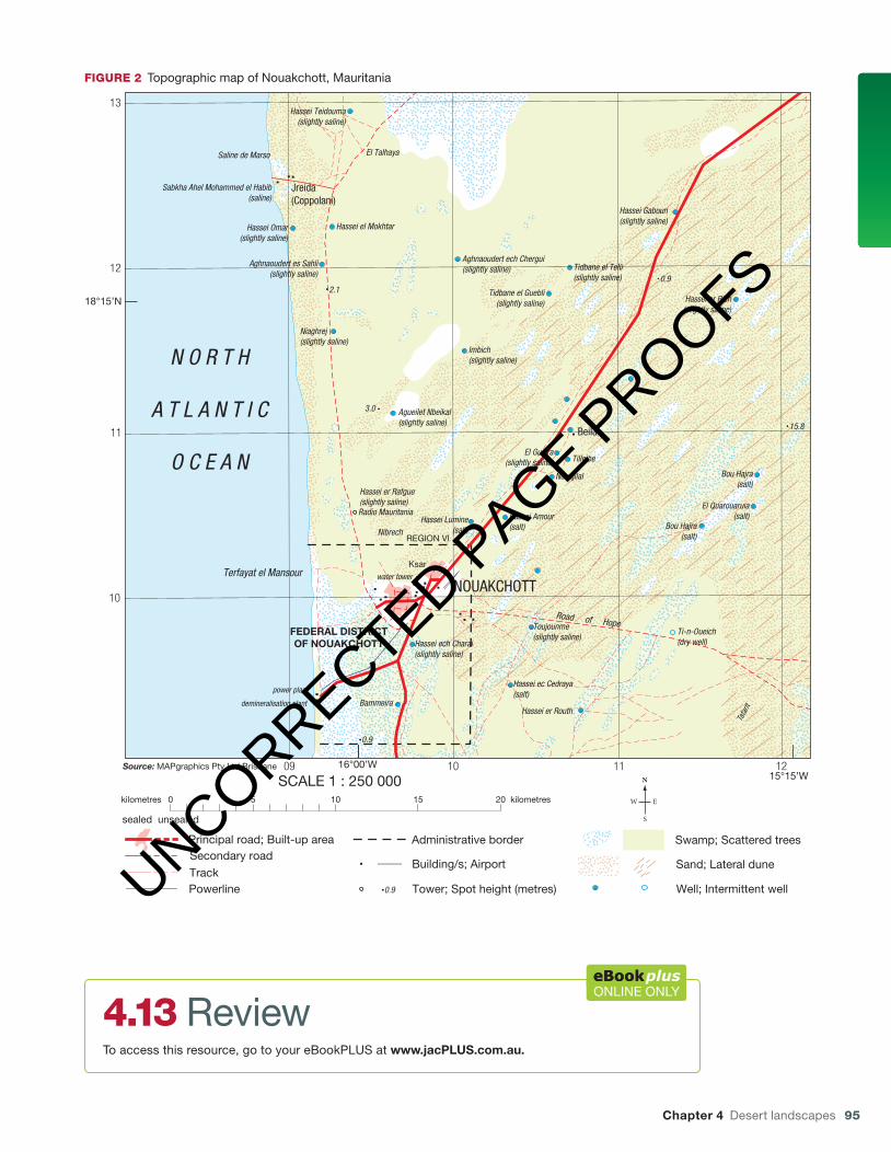
Nouakchott. 2 Refer to the topographic map of Nouakchott to
answer the following: a What landform features are shown on the
map? b What is the area reference of the city of
Nouakchott? c Using the scale, how far away is Nouakchott
from the coastline? d How close are the sand and the dunes to the
built-up areas?
PREDICT 3 What impact could the sand dunes have on the
wells? 4 What impact could the sand have on the roads?
APPLY 5 Describe how the map confi rms that
desertifi cation is a problem in Nouakchott. 6 Write a proposal to the Mauritanian
government suggesting where greenbelts should be placed. Include the area reference of where your greenbelts will go and what they will help to protect. Refer to the writing task in your eBookPLUS on how to respond to this question.
ACTIVITIES
FIGURE 1 Sand taking over in Nouakchott
greenbelts plantations of trees for the purpose of conservation
desertifi cation the process by which an area becomes a desert
4.11 Is Antarctica a desert?ONLINE ONLY
4.12 How do people use Antarctica?
ONLINE ONLY
c04DesertLandscapes.indd 94 13/10/16 12:51 pm
UNCORRECTED PAGE P
ROOFS
Chapter 4 Desert landscapes 95
18°15’N
16°00’W15°15’W
13
12
11
10
09 10 11 12
3.0
2.10.9
15.8
0.9
Jreida(Coppolani)
Beila
Ksar
E-n-Dghamcha(slightly saline)
Hassei Teidouma(slightly saline)
Hassei Omar(slightly saline)
Hassei el Mokhtar
Aghnaoudert es Sahli(slightly saline)
Aghnaoudert ech Chergui(slightly saline) Tidbane el Telli
(slightly saline)
Tidbane el Guebli (slightly saline) Hassei er Rich
(slightly saline)
Hassei Gaboun(slightly saline)
Niaghrej(slightly saline)
Agueilet Nbeikal(slightly saline)
Imbich(slightly saline)
El Gueira(slightly saline)
Hassei er Rafgue(slightly saline)
Hassei Lumine(salt)Nibrech
Hassei Amour(salt)
Nouajilal
Tilleibe
Bou Hajra(salt)
Bou Hajra(salt)
El Quarouaruia(salt)
Hassei ech Charai(slightly saline)
Bammeira
Hassei ec Cedraya(salt)
Hassei er Routh
Toujounme(slightly saline)
Ti-n-Oueich(dry well)
Terfayat el Mansour
power plant
demineralisation plant
Saline de Marso
Sabkha Ahel Mohammed el Habib(saline)
El Talhaya
Radio Mauritania
water tower
T E G O U R A R E T E S S B A K H
AGUEILE
T
T
ARGUE
FEDERAL DISTRICTOF NOUAKCHOTT
REGION VI
Tafa
rit
N O R T H
A T L A N T I C
O C E A N
NOUAKCHOTT
Building/s; Airport
Tower; Spot height (metres)
Swamp; Scattered trees
Sand; Lateral dune
Administrative border
0 5 10 15 20kilometres kilometres
SCALE 1 : 250 000
Well; Intermittent well0.9
Principal road; Built-up area
sealed unsealed
Secondary road
Track
Road of Hope
Powerline
Source: MAPgraphics Pty Ltd Brisbane
FIGURE 2 Topographic map of Nouakchott, Mauritania
4.13 ReviewTo access this resource, go to your eBookPLUS at www.jacPLUS.com.au.
ONLINE ONLY
c04DesertLandscapes.indd 95 13/10/16 12:52 pm
UNCORRECTED PAGE P
ROOFS