Embed Size (px)
Citation preview
Design and Access Statement Volume III Part 4 of 9Plot A1
May 2018
Allies and Morrison


67 CANADA WATER MASTERPLAN PLOT A1 Design and Access Statement May 2018
4 PROPOSED SCHEME
68 CANADA WATER MASTERPLAN PLOT A1 Design and Access Statement May 2018
4 Proposed scheme
Ground Floor
Typical Floor office
29th Floor
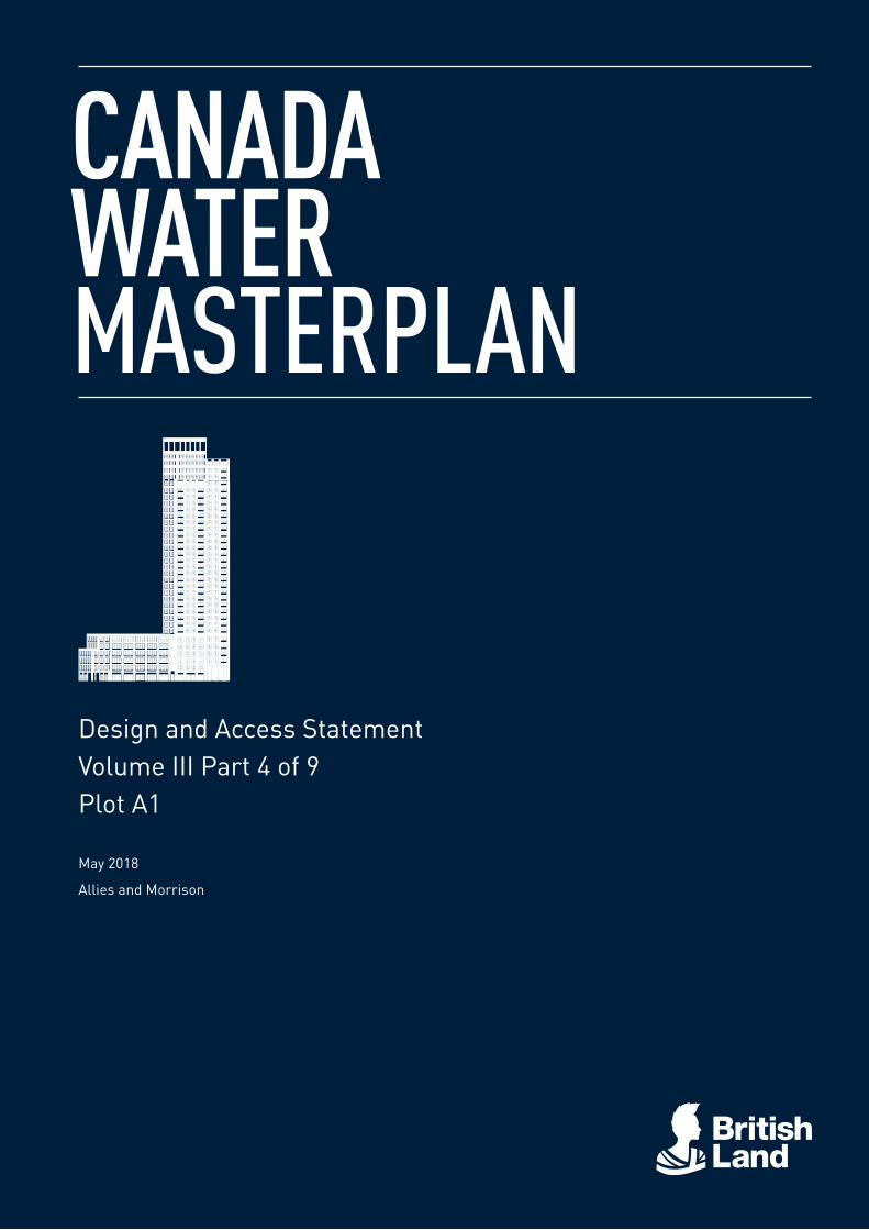
Plot A1 is a mixed-use development combining office, retail and residential uses as part of the wider Canada Water Masterplan redevelopment. Please refer to the masterplan DAS to understand broader distribution of uses across the wider site.
With most parts of the ground floor occupied by retail and main building entrances, the public realm will benefit from active uses linked directly with the emerging High Street on Deal Porters Way. With one of the larger retail units (which can be divided into two units) facing the former Dock Offices, there is the opportunity to reactivate this historic space and create a particular character within an intimate, yet public setting.
Two main entrances enrich the street space around the building. The residential entrance faces Canada Water Station and is highly visible from the north. The office entrance links to a generous entrance hall, proposed as semi-public space providing a cafe area and informal tables for ad hoc meetings. A route links through to the Dock Offices Courtyard with a secondary entrance.
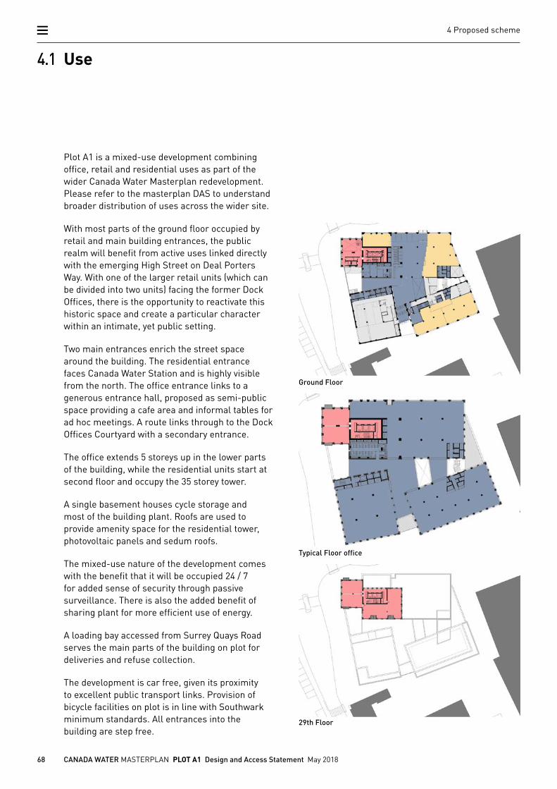
The office extends 5 storeys up in the lower parts of the building, while the residential units start at second floor and occupy the 35 storey tower.
A single basement houses cycle storage and most of the building plant. Roofs are used to provide amenity space for the residential tower, photovoltaic panels and sedum roofs.
The mixed-use nature of the development comes with the benefit that it will be occupied 24 / 7 for added sense of security through passive surveillance. There is also the added benefit of sharing plant for more efficient use of energy.
A loading bay accessed from Surrey Quays Road serves the main parts of the building on plot for deliveries and refuse collection.
The development is car free, given its proximity to excellent public transport links. Provision of bicycle facilities on plot is in line with Southwark minimum standards. All entrances into the building are step free.
4.1 Use
69 CANADA WATER MASTERPLAN PLOT A1 Design and Access Statement May 2018
4 Proposed scheme
Basement 1st Floor
6th Floor 7th to 28th Floor
32nd Floor
KeyRetail
Office
Residential
Plant/Services
34th Floor
70 CANADA WATER MASTERPLAN PLOT A1 Design and Access Statement May 2018
4 Proposed scheme
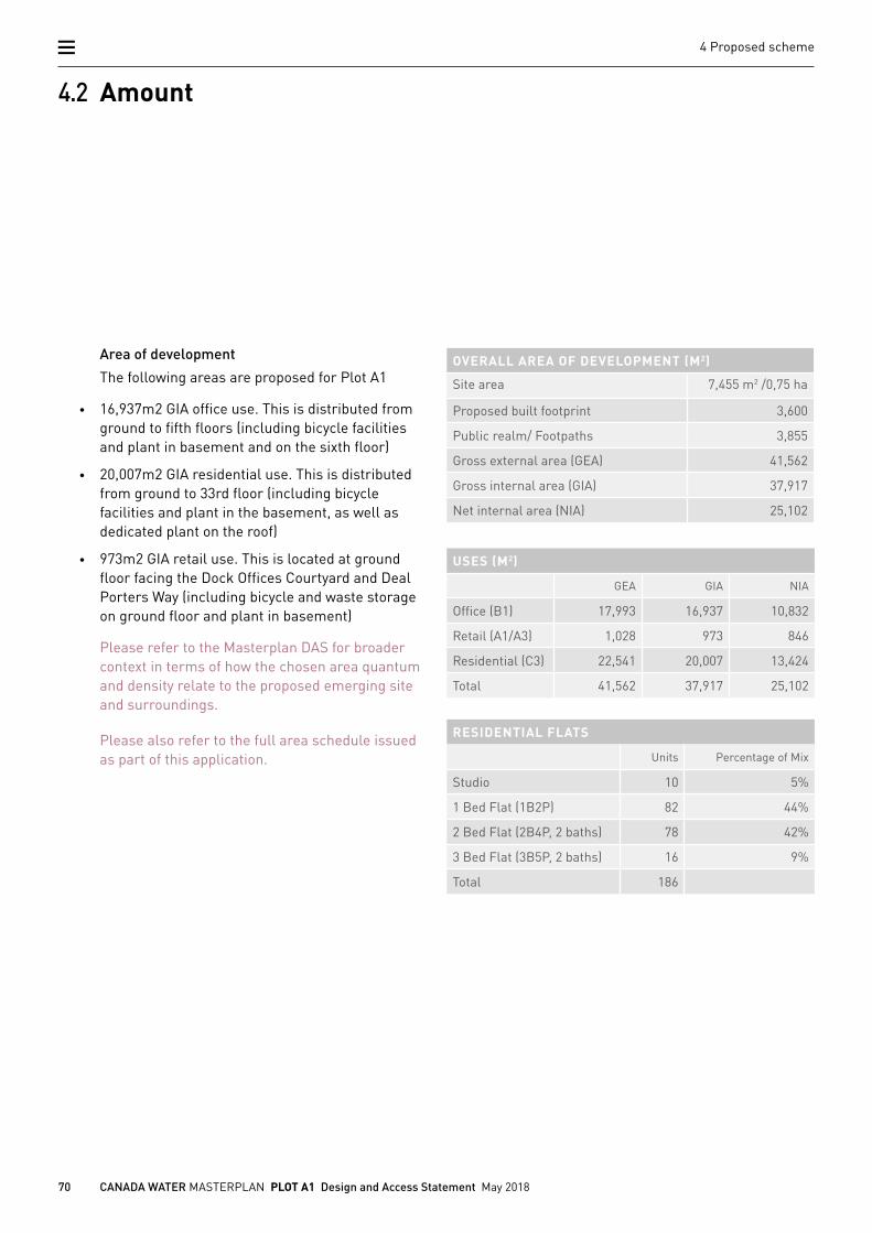
4.2 Amount
Area of development
The following areas are proposed for Plot A1
• 16,937m2 GIA office use. This is distributed from ground to fifth floors (including bicycle facilities and plant in basement and on the sixth floor)
• 20,007m2 GIA residential use. This is distributed from ground to 33rd floor (including bicycle facilities and plant in the basement, as well as dedicated plant on the roof)
• 973m2 GIA retail use. This is located at ground floor facing the Dock Offices Courtyard and Deal Porters Way (including bicycle and waste storage on ground floor and plant in basement)
Please refer to the Masterplan DAS for broader context in terms of how the chosen area quantum and density relate to the proposed emerging site and surroundings.
Please also refer to the full area schedule issued as part of this application.
OVERALL AREA OF DEVELOPMENT (M2)
Site area 7,455 m2 /0,75 ha
Proposed built footprint 3,600
Public realm/ Footpaths 3,855
Gross external area (GEA) 41,562
Gross internal area (GIA) 37,917
Net internal area (NIA) 25,102
USES (M2)
GEA GIA NIA
Office (B1) 17,993 16,937 10,832
Retail (A1/A3) 1,028 973 846
Residential (C3) 22,541 20,007 13,424
Total 41,562 37,917 25,102
RESIDENTIAL FLATS
Units Percentage of Mix
Studio 10 5%
1 Bed Flat (1B2P) 82 44%
2 Bed Flat (2B4P, 2 baths) 78 42%
3 Bed Flat (3B5P, 2 baths) 16 9%
Total 186
71 CANADA WATER MASTERPLAN PLOT A1 Design and Access Statement May 2018
4 Proposed scheme
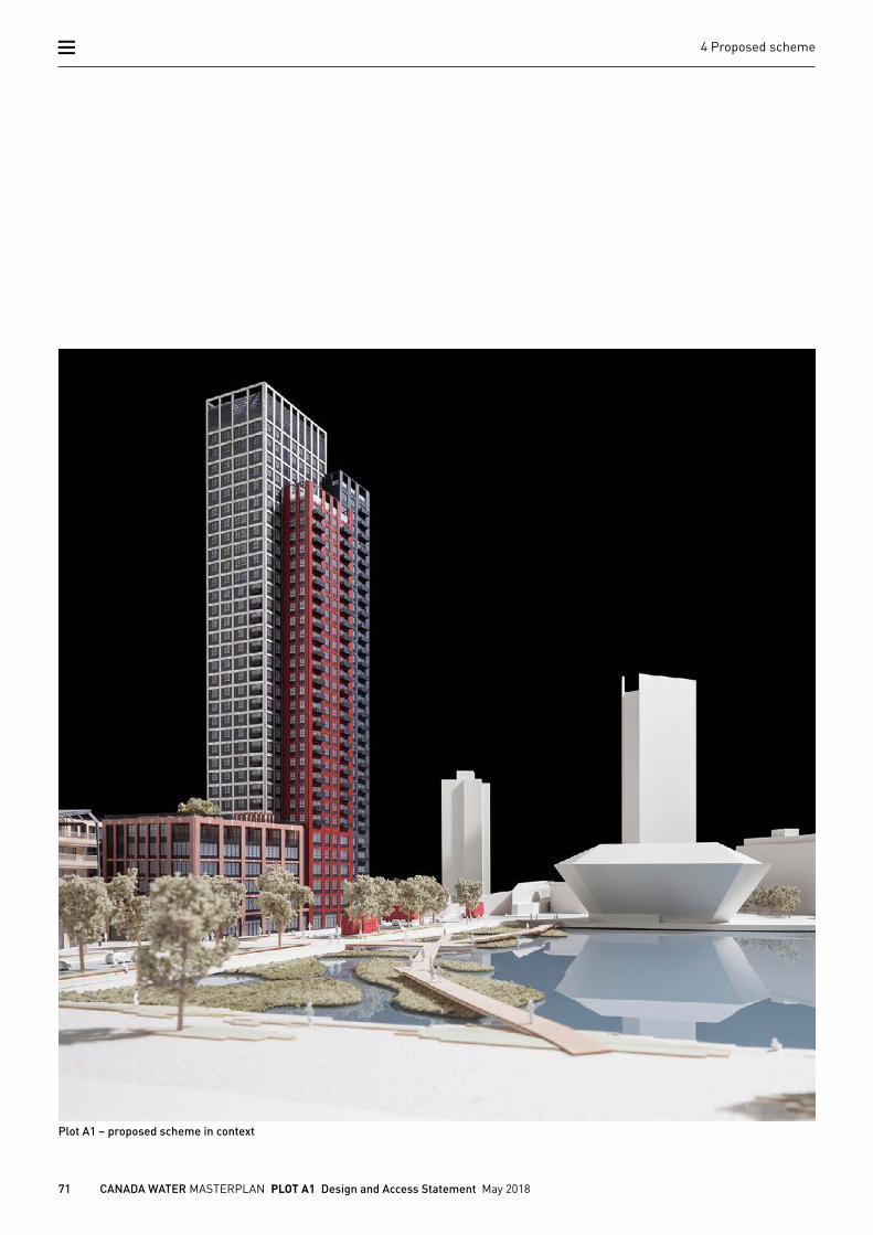
Plot A1 – proposed scheme in context
72 CANADA WATER MASTERPLAN PLOT A1 Design and Access Statement May 2018
4 Proposed scheme
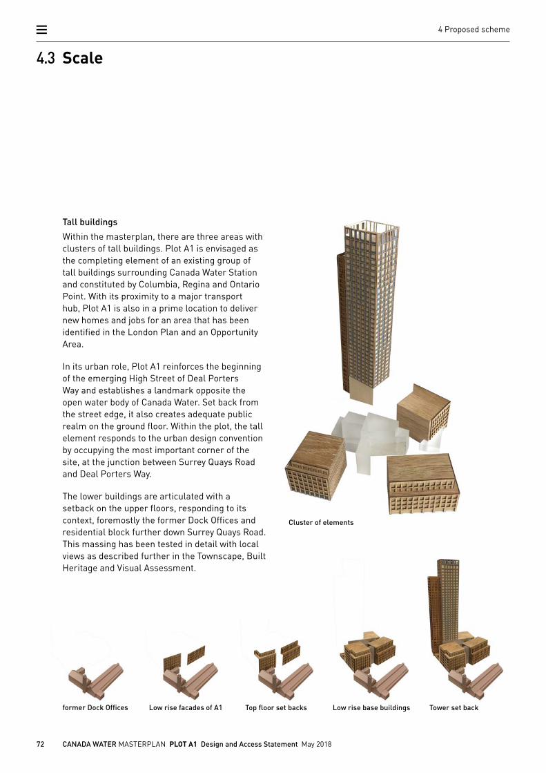
4.3 Scale
Cluster of elements
Tall buildings
Within the masterplan, there are three areas with clusters of tall buildings. Plot A1 is envisaged as the completing element of an existing group of tall buildings surrounding Canada Water Station and constituted by Columbia, Regina and Ontario Point. With its proximity to a major transport hub, Plot A1 is also in a prime location to deliver new homes and jobs for an area that has been identified in the London Plan and an Opportunity Area.
In its urban role, Plot A1 reinforces the beginning of the emerging High Street of Deal Porters Way and establishes a landmark opposite the open water body of Canada Water. Set back from the street edge, it also creates adequate public realm on the ground floor. Within the plot, the tall element responds to the urban design convention by occupying the most important corner of the site, at the junction between Surrey Quays Road and Deal Porters Way.
The lower buildings are articulated with a setback on the upper floors, responding to its context, foremostly the former Dock Offices and residential block further down Surrey Quays Road. This massing has been tested in detail with local views as described further in the Townscape, Built Heritage and Visual Assessment.
former Dock Offices Low rise facades of A1 Top floor set backs Low rise base buildings Tower set back
73 CANADA WATER MASTERPLAN PLOT A1 Design and Access Statement May 2018
4 Proposed scheme
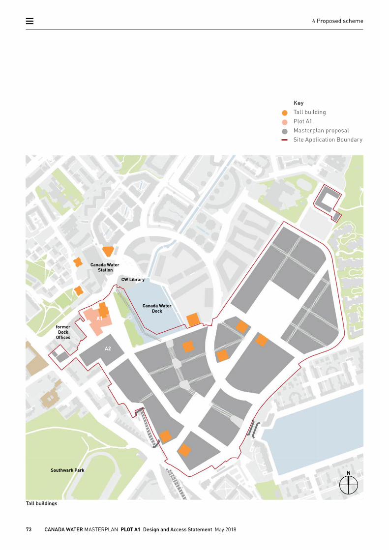
Tall buildings
Canada WaterDock
CW Library
Canada Water Station
A1
A2
former Dock
Offices
Southwark Park N
KeyTall building
Plot A1
Masterplan proposal
Site Application Boundary
Tower set back
74 CANADA WATER MASTERPLAN PLOT A1 Design and Access Statement May 2018
4 Proposed scheme
Site plan
Small grain
Large grain
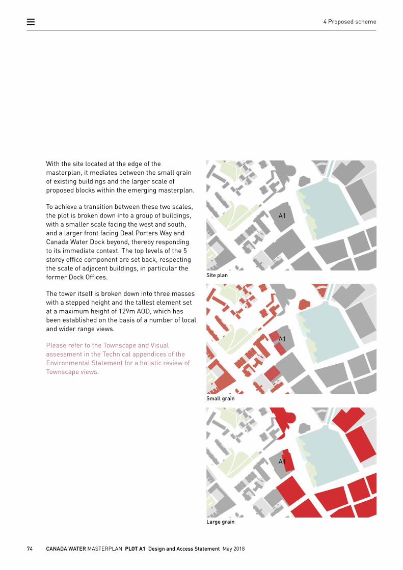
With the site located at the edge of the masterplan, it mediates between the small grain of existing buildings and the larger scale of proposed blocks within the emerging masterplan.
To achieve a transition between these two scales, the plot is broken down into a group of buildings, with a smaller scale facing the west and south, and a larger front facing Deal Porters Way and Canada Water Dock beyond, thereby responding to its immediate context. The top levels of the 5 storey office component are set back, respecting the scale of adjacent buildings, in particular the former Dock Offices.
The tower itself is broken down into three masses with a stepped height and the tallest element set at a maximum height of 129m AOD, which has been established on the basis of a number of local and wider range views.
Please refer to the Townscape and Visual assessment in the Technical appendices of the Environmental Statement for a holistic review of Townscape views.
A1
A1
A1
75 CANADA WATER MASTERPLAN PLOT A1 Design and Access Statement May 2018
4 Proposed scheme
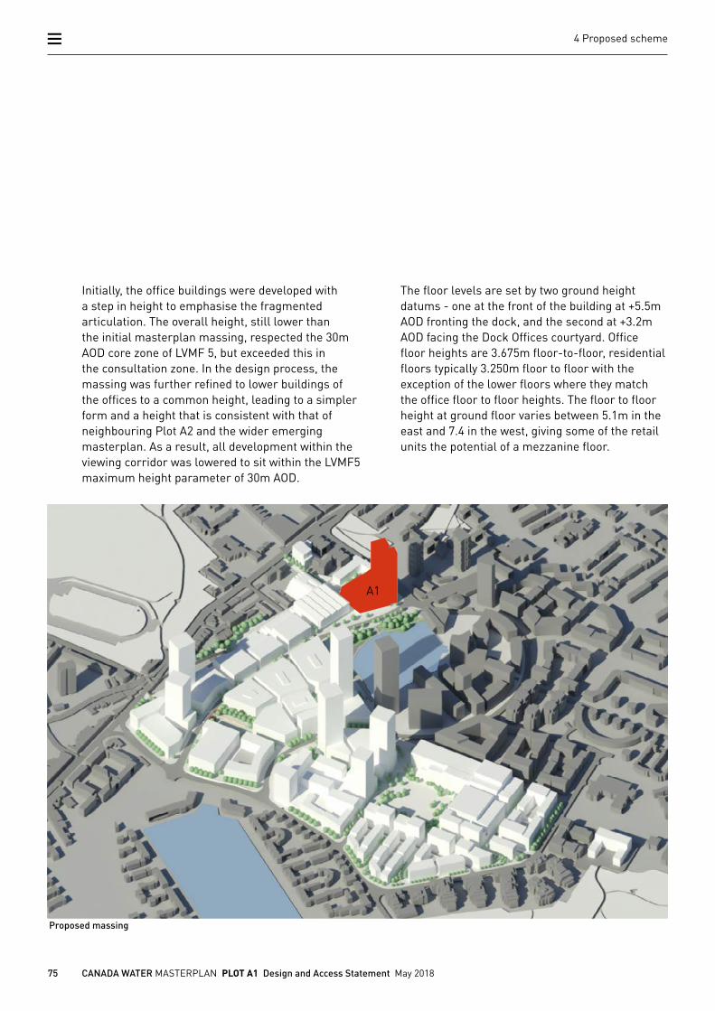
Initially, the office buildings were developed with a step in height to emphasise the fragmented articulation. The overall height, still lower than the initial masterplan massing, respected the 30m AOD core zone of LVMF 5, but exceeded this in the consultation zone. In the design process, the massing was further refined to lower buildings of the offices to a common height, leading to a simpler form and a height that is consistent with that of neighbouring Plot A2 and the wider emerging masterplan. As a result, all development within the viewing corridor was lowered to sit within the LVMF5 maximum height parameter of 30m AOD.
The floor levels are set by two ground height datums - one at the front of the building at +5.5m AOD fronting the dock, and the second at +3.2m AOD facing the Dock Offices courtyard. Office floor heights are 3.675m floor-to-floor, residential floors typically 3.250m floor to floor with the exception of the lower floors where they match the office floor to floor heights. The floor to floor height at ground floor varies between 5.1m in the east and 7.4 in the west, giving some of the retail units the potential of a mezzanine floor.
Proposed massing
A1
76 CANADA WATER MASTERPLAN PLOT A1 Design and Access Statement May 2018
4 Proposed scheme
4.4 Layout
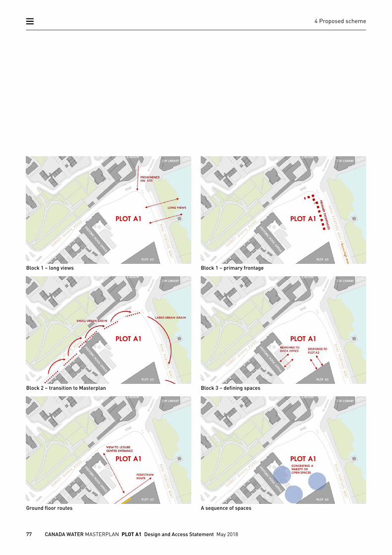
4.4.1 RESPONSE TO URBAN CONTEXTPlot A1 is in a prominent location within the Masterplan, and within Rotherhithe, facing Canada Water Station and the library with its north-east corner. Towards the east, the openness of the Canada Water Dock allows long views of the building, making this elevation a primary frontage.
The initial massing for Plot A1 proposed a single building for the footprint of the plot with a tower located in the north-east corner of the site. However, in consideration of the adjacent neighbourhood, a change in scale seemed a more suitable response to a rich context, in particular to the former Dock Offices and buildings along Surrey Quays Road.
Immediate adjacencies with the former Dock Offices and emerging designs for Plot A2 provide a more local setting for the western and southern edge of the plot. Here, opportunities allow for enhancement of the Dock Offices Courtyard and the creation of a visual connection for a future entrance to the potential leisure centre on Plot A2.
77 CANADA WATER MASTERPLAN PLOT A1 Design and Access Statement May 2018
4 Proposed scheme
Block 1 – long views Block 1 – primary frontage
Block 2 – transition to Masterplan Block 3 – defining spaces
Ground floor routes A sequence of spaces
78 CANADA WATER MASTERPLAN PLOT A1 Design and Access Statement May 2018
4 Proposed scheme
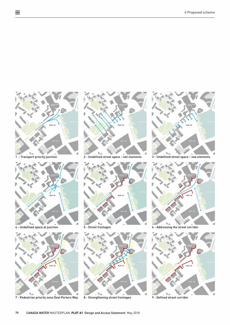
Street corridor
The intersection of Surrey Quays Road (SQR) and Deal Porters Way (DPW) on the north-east corner of Plot A1 is currently characterised as a transport priority junction which is dominated by the car. Further to this, the street corridor of DPW is ill defined with intermittent street frontage in particular to the northern edge and in proximity to the junction.
Plot A1 has the opportunity to improve this situation and give the road a better defined edge. This is supported by the introduction of a future pedestrian priority High Street on DPW, limiting general traffic to SQR
These changes improve the definition of SQR, clarify the junction of DPW and SQR and improve pedestrian movement in this area. With clear building lines, Plot A1 will help to define the road spaces and provide an appropriate backdrop for the two roads at this junction.
79 CANADA WATER MASTERPLAN PLOT A1 Design and Access Statement May 2018
4 Proposed scheme
1 - Transport priority junction 2 - Undefined street space – tall elements 3 - Undefined street space – low elements
4 - Undefined space at junction 5 - Street frontages 6 - Addressing the street corridor
7 - Pedestrian priority zone Deal Porters Way 8 - Strengthening street frontages 9 - Defined street corridor
80 CANADA WATER MASTERPLAN PLOT A1 Design and Access Statement May 2018
4 Proposed scheme
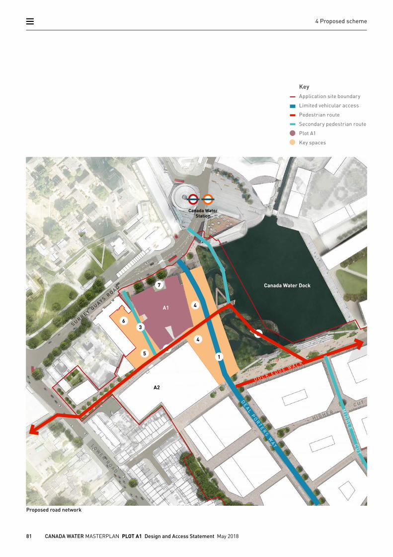
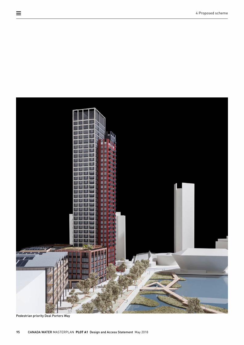
4.4.2 EMERGING ROAD NET WORKIn the emerging Masterplan, Deal Porters Way will be reshaped to link between Canada Water Station and Surrey Quays Station and become a high street, one of the distinct character areas of the Masterplan. The High Street will be a pedestrian priority environment, allowing buses and taxis, but limiting the use of private cars. Plot A1 is located at the northern end of this road.
The only remaining car priority road will be Surrey Quays Road, where the entrance to the loading bay for Plot A1 will be located.
Key routes
1. Plot A1 fronts Deal Porters Way, a primary route running north/ south linking Canada Water Station with the proposed High Street leading to the Town Square and Surrey Quays Station
2. Running transverse to this is a new accessible pedestrian route connecting The Park adjacent to the Printworks with Southwark Park.
3. The western edge of Plot A1 has been set out to create a new public route past the former Dock Offices, leading to the main entrance to the proposed location of the leisure centre on Plot A2.
Key spaces
4. To the east is Canada Water Dock and the public realm fronting the dock edge. An enlargement of the footpath between Plot A1 and A2 creates a distinct space at the northern end of the future High Street.
5. The Community Square is located adjacent to the entrance of the Leisure Centre on Plot A2.
6. To the west of Plot A1 is the Dock Offices Courtyard. The proposal is for this to be re-landscaped to create an intimate new courtyard.
7. A small garden along the northern facade of Plot A1 creates a visual amenity for office and residential users. Three existing plane trees along Surrey Quays Road will be retained.
81 CANADA WATER MASTERPLAN PLOT A1 Design and Access Statement May 2018
4 Proposed scheme
Proposed road network
H I G H E R C U T
Canada Water Dock
Canada WaterStation
LOW
E R R
OA
D
SU
RR
EY
QU
AY
S R
OA
DD O C K OF F I C E W
A L K
DE
AL
PO
RT
ER
S W
AY
MI D
DL
E C
UT
D O C K E D G E W A L K
A2
A1
1
2
2
4
6
KeyApplication site boundary
Limited vehicular access
Pedestrian route
Secondary pedestrian route
Plot A1
Key spaces
5
4
7
S U R R E Y QU AY S R
O A D
3
82 CANADA WATER MASTERPLAN PLOT A1 Design and Access Statement May 2018
4 Proposed scheme
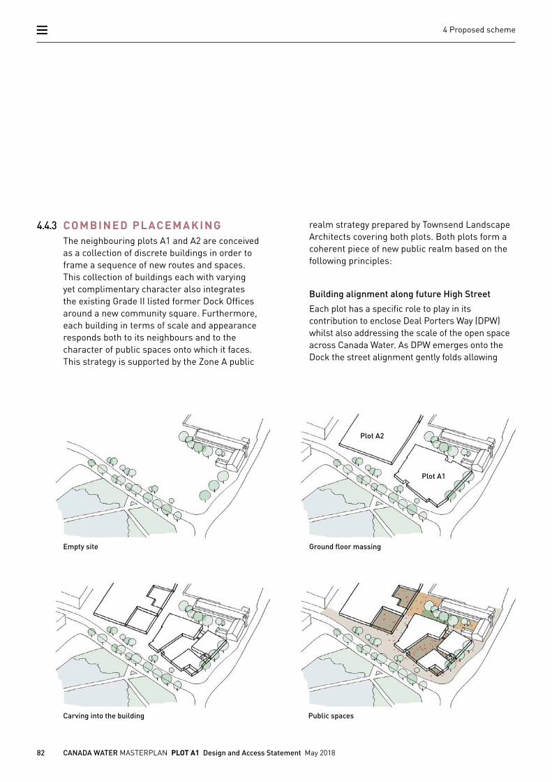
4.4.3 COMBINED PLACEMAKINGThe neighbouring plots A1 and A2 are conceived as a collection of discrete buildings in order to frame a sequence of new routes and spaces. This collection of buildings each with varying yet complimentary character also integrates the existing Grade II listed former Dock Offices around a new community square. Furthermore, each building in terms of scale and appearance responds both to its neighbours and to the character of public spaces onto which it faces. This strategy is supported by the Zone A public
Empty site Ground floor massing
Carving into the building Public spaces
realm strategy prepared by Townsend Landscape Architects covering both plots. Both plots form a coherent piece of new public realm based on the following principles:
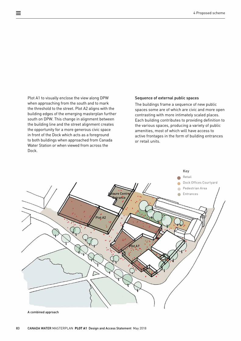
Building alignment along future High Street
Each plot has a specific role to play in its contribution to enclose Deal Porters Way (DPW) whilst also addressing the scale of the open space across Canada Water. As DPW emerges onto the Dock the street alignment gently folds allowing
Plot A2
Plot A1
83 CANADA WATER MASTERPLAN PLOT A1 Design and Access Statement May 2018
4 Proposed scheme
A combined approach
Plot A1 to visually enclose the view along DPW when approaching from the south and to mark the threshold to the street. Plot A2 aligns with the building edges of the emerging masterplan further south on DPW. This change in alignment between the building line and the street alignment creates the opportunity for a more generous civic space in front of the Dock which acts as a foreground to both buildings when approached from Canada Water Station or when viewed from across the Dock.
Sequence of external public spaces
The buildings frame a sequence of new public spaces some are of which are civic and more open contrasting with more intimately scaled places. Each building contributes to providing definition to the various spaces, producing a variety of public amenities, most of which will have access to active frontages in the form of building entrances or retail units.
Plot A2
Leisure CentreEntrance
Plot A1
KeyRetail
Dock Offices Courtyard
Pedestrian Area
Entrances
84 CANADA WATER MASTERPLAN PLOT A1 Design and Access Statement May 2018
4 Proposed scheme
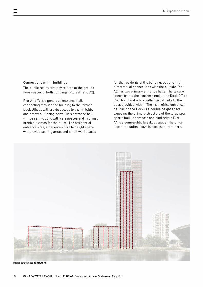
Connections within buildings
The public realm strategy relates to the ground floor spaces of both buildings (Plots A1 and A2).
Plot A1 offers a generous entrance hall, connecting through the building to the former Dock Offices with a side access to the lift lobby and a view out facing north. This entrance hall will be semi-public with cafe spaces and informal break out areas for the office. The residential entrance area, a generous double height space will provide seating areas and small workspaces
for the residents of the building, but offering direct visual connections with the outside. Plot A2 has two primary entrance halls. The leisure centre fronts the southern end of the Dock Office Courtyard and offers within visual links to the uses provided within. The main office entrance hall facing the Dock is a double height space, exposing the primary structure of the large span sports hall underneath and similarly to Plot A1 is a semi-public breakout space. The office accommodation above is accessed from here.
Hight street facade rhythm
85 CANADA WATER MASTERPLAN PLOT A1 Design and Access Statement May 2018
4 Proposed scheme
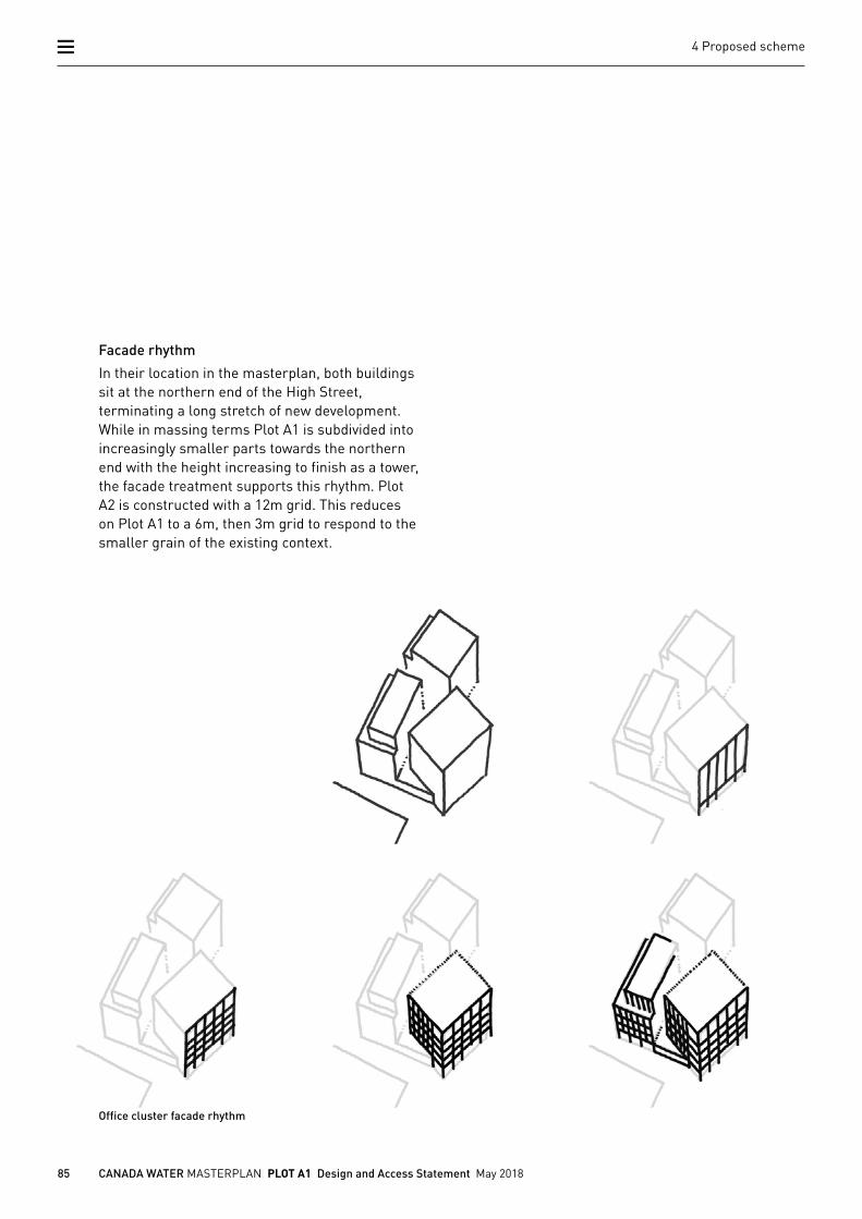
Facade rhythm
In their location in the masterplan, both buildings sit at the northern end of the High Street, terminating a long stretch of new development. While in massing terms Plot A1 is subdivided into increasingly smaller parts towards the northern end with the height increasing to finish as a tower, the facade treatment supports this rhythm. Plot A2 is constructed with a 12m grid. This reduces on Plot A1 to a 6m, then 3m grid to respond to the smaller grain of the existing context.
Office cluster facade rhythm
86 CANADA WATER MASTERPLAN PLOT A1 Design and Access Statement May 2018
4 Proposed scheme
1- Surrey Quays Road looking south
2 - Between Plot A1 and former Dock Offices
3 - Past former Dock Offices
4 - In Dock Offices Courtyard
5 - Plot A2 leisure centre entrance
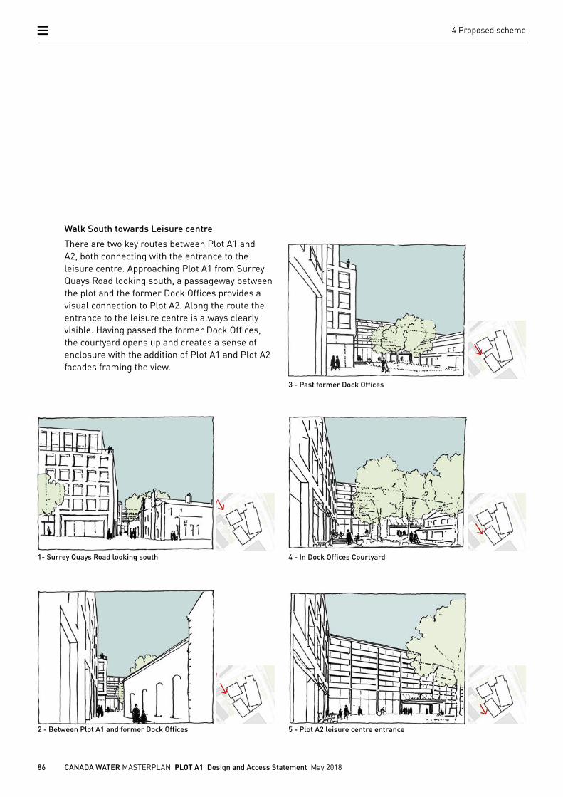
Walk South towards Leisure centre
There are two key routes between Plot A1 and A2, both connecting with the entrance to the leisure centre. Approaching Plot A1 from Surrey Quays Road looking south, a passageway between the plot and the former Dock Offices provides a visual connection to Plot A2. Along the route the entrance to the leisure centre is always clearly visible. Having passed the former Dock Offices, the courtyard opens up and creates a sense of enclosure with the addition of Plot A1 and Plot A2 facades framing the view.
87 CANADA WATER MASTERPLAN PLOT A1 Design and Access Statement May 2018
4 Proposed scheme
1 - Crossing Deal Porters way
2 - In between Plot A1 and A2
3 - In between Plot A1 and A2
4 - In front of the leisure centre entrance
5 - Dock Offices Courtyard
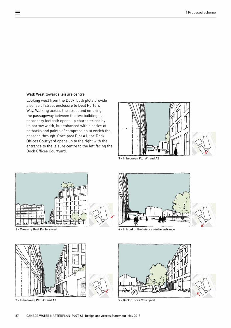
Walk West towards leisure centre
Looking west from the Dock, both plots provide a sense of street enclosure to Deal Porters Way. Walking across the street and entering the passageway between the two buildings, a secondary footpath opens up characterised by its narrow width, but enhanced with a series of setbacks and points of compression to enrich the passage through. Once past Plot A1, the Dock Offices Courtyard opens up to the right with the entrance to the leisure centre to the left facing the Dock Offices Courtyard.
88 CANADA WATER MASTERPLAN PLOT A1 Design and Access Statement May 2018
4 Proposed scheme
89 CANADA WATER MASTERPLAN PLOT A1 Design and Access Statement May 2018
4 Proposed scheme
90 CANADA WATER MASTERPLAN PLOT A1 Design and Access Statement May 2018
4 Proposed scheme
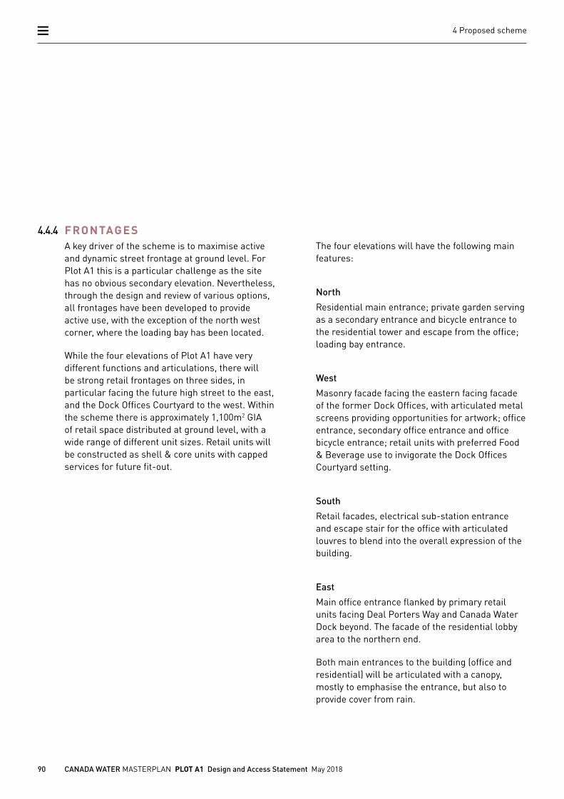
The four elevations will have the following main features:
North
Residential main entrance; private garden serving as a secondary entrance and bicycle entrance to the residential tower and escape from the office; loading bay entrance.
West
Masonry facade facing the eastern facing facade of the former Dock Offices, with articulated metal screens providing opportunities for artwork; office entrance, secondary office entrance and office bicycle entrance; retail units with preferred Food & Beverage use to invigorate the Dock Offices Courtyard setting.
South
Retail facades, electrical sub-station entrance and escape stair for the office with articulated louvres to blend into the overall expression of the building.
East
Main office entrance flanked by primary retail units facing Deal Porters Way and Canada Water Dock beyond. The facade of the residential lobby area to the northern end.
Both main entrances to the building (office and residential) will be articulated with a canopy, mostly to emphasise the entrance, but also to provide cover from rain.
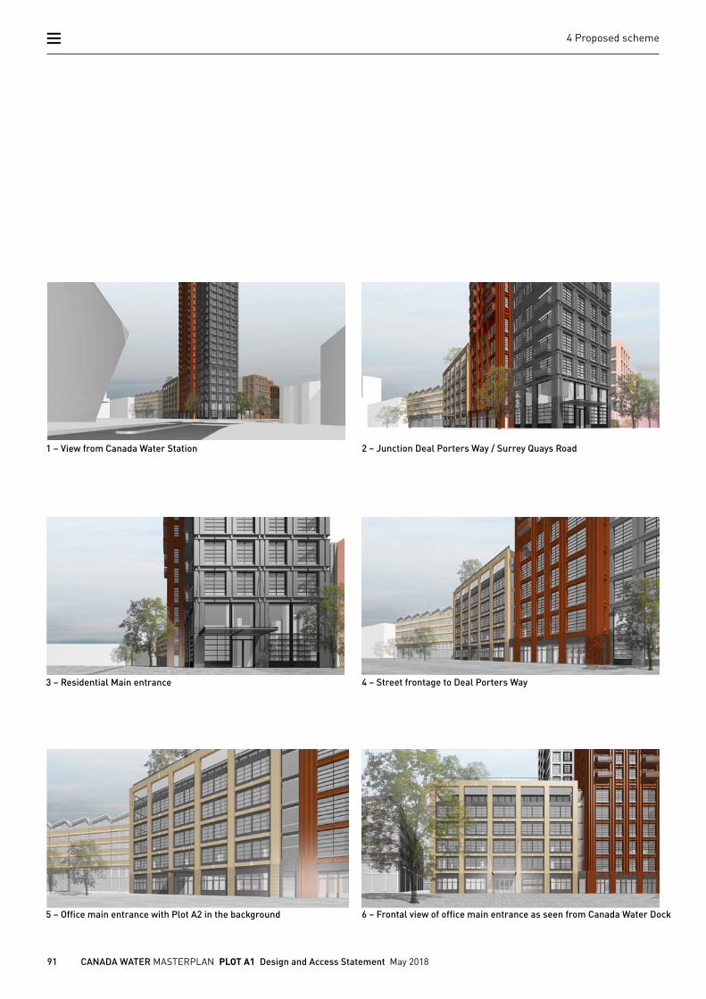
4.4.4 FRONTAGESA key driver of the scheme is to maximise active and dynamic street frontage at ground level. For Plot A1 this is a particular challenge as the site has no obvious secondary elevation. Nevertheless, through the design and review of various options, all frontages have been developed to provide active use, with the exception of the north west corner, where the loading bay has been located.
While the four elevations of Plot A1 have very different functions and articulations, there will be strong retail frontages on three sides, in particular facing the future high street to the east, and the Dock Offices Courtyard to the west. Within the scheme there is approximately 1,100m2 GIA of retail space distributed at ground level, with a wide range of different unit sizes. Retail units will be constructed as shell & core units with capped services for future fit-out.
91 CANADA WATER MASTERPLAN PLOT A1 Design and Access Statement May 2018
4 Proposed scheme
1 – View from Canada Water Station
3 – Residential Main entrance
5 – Office main entrance with Plot A2 in the background
2 – Junction Deal Porters Way / Surrey Quays Road
4 – Street frontage to Deal Porters Way
6 – Frontal view of office main entrance as seen from Canada Water Dock
92 CANADA WATER MASTERPLAN PLOT A1 Design and Access Statement May 2018
4 Proposed scheme
4.4.5 ACCESS
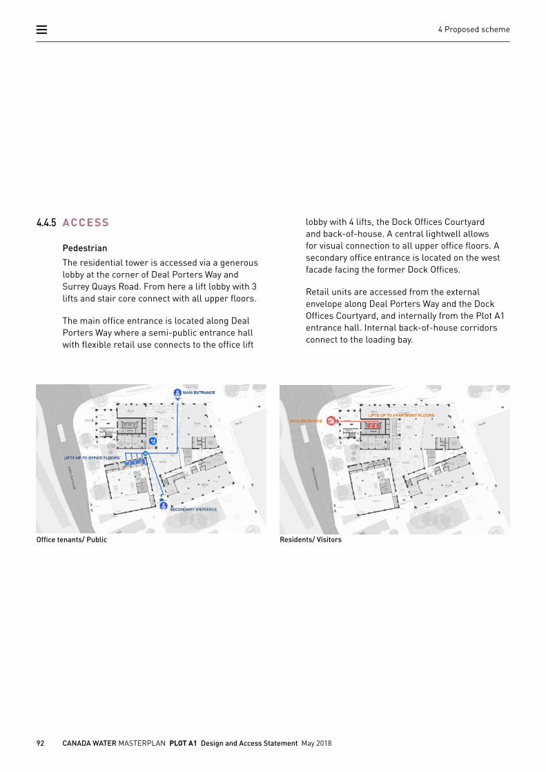
Pedestrian
The residential tower is accessed via a generous lobby at the corner of Deal Porters Way and Surrey Quays Road. From here a lift lobby with 3 lifts and stair core connect with all upper floors.
The main office entrance is located along Deal Porters Way where a semi-public entrance hall with flexible retail use connects to the office lift
Office tenants/ Public Residents/ Visitors
lobby with 4 lifts, the Dock Offices Courtyard and back-of-house. A central lightwell allows for visual connection to all upper office floors. A secondary office entrance is located on the west facade facing the former Dock Offices.
Retail units are accessed from the external envelope along Deal Porters Way and the Dock Offices Courtyard, and internally from the Plot A1 entrance hall. Internal back-of-house corridors connect to the loading bay.
93 CANADA WATER MASTERPLAN PLOT A1 Design and Access Statement May 2018
4 Proposed scheme
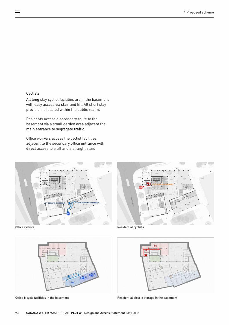
Cyclists
All long stay cyclist facilities are in the basement with easy access via stair and lift. All short stay provision is located within the public realm.
Residents access a secondary route to the basement via a small garden area adjacent the main entrance to segregate traffic.
Office workers access the cyclist facilities adjacent to the secondary office entrance with direct access to a lift and a straight stair.
Office cyclists
Office bicycle facilities in the basement
Residential cyclists
Residential bicycle storage in the basement
94 CANADA WATER MASTERPLAN PLOT A1 Design and Access Statement May 2018
4 Proposed scheme
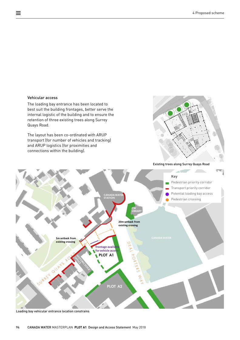
Vehicular access
The loading bay entrance has been located to best suit the building frontages, better serve the internal logistic of the building and to ensure the retention of three existing trees along Surrey Quays Road.
The layout has been co-ordinated with ARUP transport (for number of vehicles and tracking) and ARUP logistics (for proximities and connections within the building).
Loading bay vehicular entrance location constrainsHighways setbacks
20m setback from existing crossing
5m setback from existing crossing
frontage available for vehicle access
CW LIBRARY
PLOT A2
CANADA WATER STATION
CANADA WATER
PLOT A1
Existing trees along Surrey Quays Road
KeyPedestrian priority corridor
Transport priority corridor
Potential loading bay access
Pedestrian crossing
95 CANADA WATER MASTERPLAN PLOT A1 Design and Access Statement May 2018
4 Proposed scheme
Pedestrian priority Deal Porters Way
96 CANADA WATER MASTERPLAN PLOT A1 Design and Access Statement May 2018
4 Proposed scheme
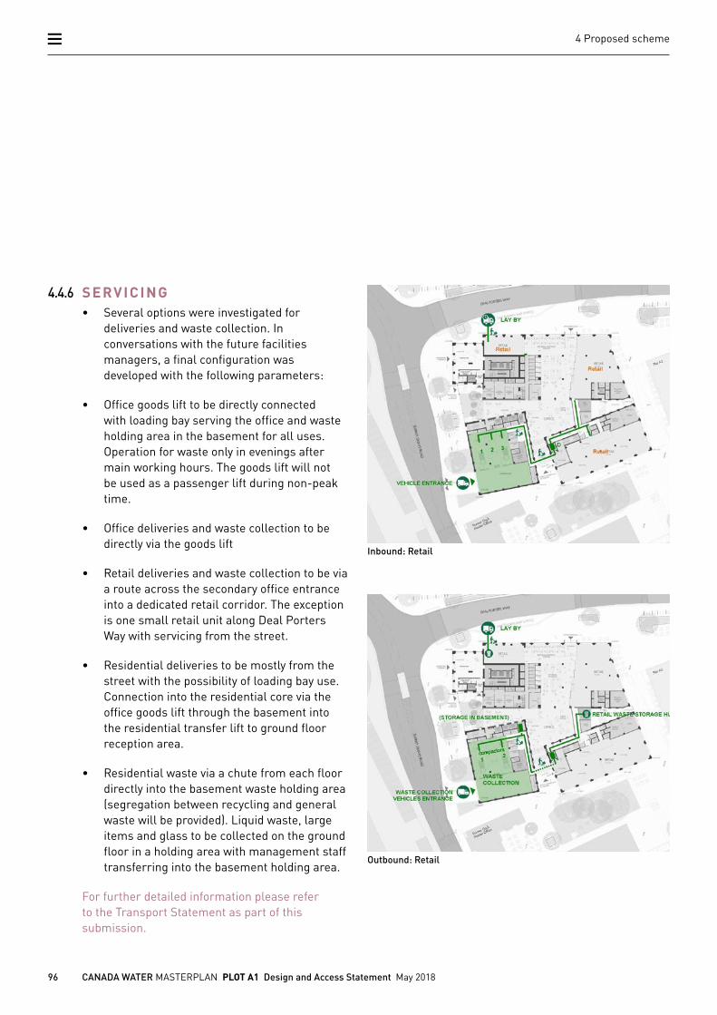
4.4.6 SERVICING• Several options were investigated for
deliveries and waste collection. In conversations with the future facilities managers, a final configuration was developed with the following parameters:
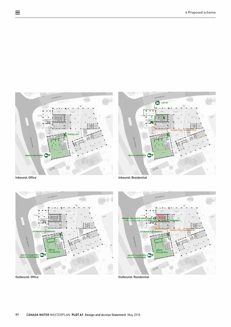
• Office goods lift to be directly connected with loading bay serving the office and waste holding area in the basement for all uses. Operation for waste only in evenings after main working hours. The goods lift will not be used as a passenger lift during non-peak time.
• Office deliveries and waste collection to be directly via the goods lift
• Retail deliveries and waste collection to be via a route across the secondary office entrance into a dedicated retail corridor. The exception is one small retail unit along Deal Porters Way with servicing from the street.
• Residential deliveries to be mostly from the street with the possibility of loading bay use. Connection into the residential core via the office goods lift through the basement into the residential transfer lift to ground floor reception area.
• Residential waste via a chute from each floor directly into the basement waste holding area (segregation between recycling and general waste will be provided). Liquid waste, large items and glass to be collected on the ground floor in a holding area with management staff transferring into the basement holding area.
For further detailed information please refer to the Transport Statement as part of this submission.
Inbound: Retail
Outbound: Retail
97 CANADA WATER MASTERPLAN PLOT A1 Design and Access Statement May 2018
4 Proposed scheme
Inbound: Office Inbound: Residential
Outbound: Office Outbound: Residential
98 CANADA WATER MASTERPLAN PLOT A1 Design and Access Statement May 2018
4 Proposed scheme
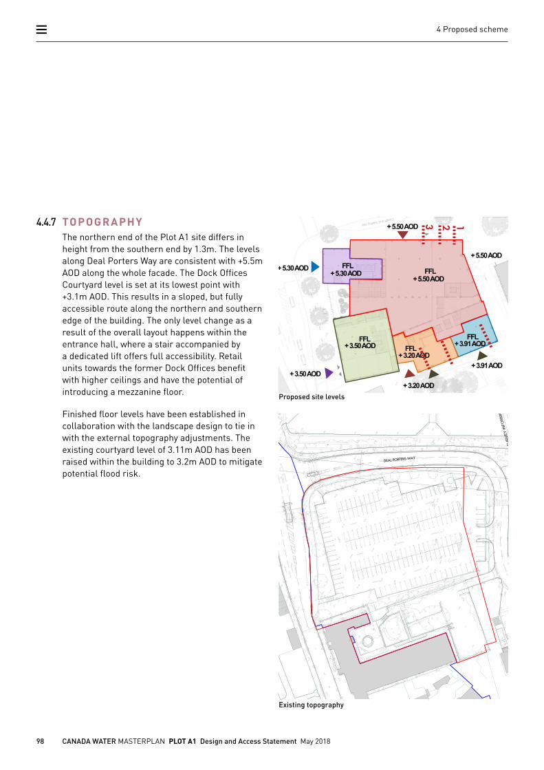
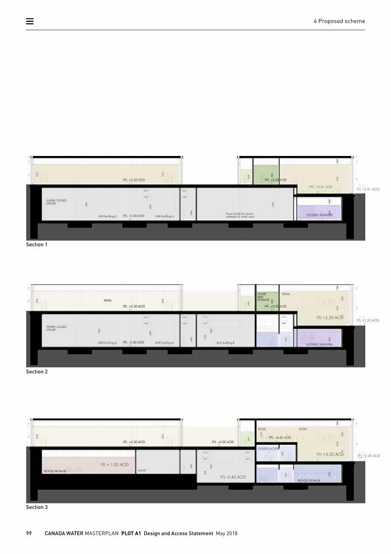
4.4.7 TOPOGRAPHYThe northern end of the Plot A1 site differs in height from the southern end by 1.3m. The levels along Deal Porters Way are consistent with +5.5m AOD along the whole facade. The Dock Offices Courtyard level is set at its lowest point with +3.1m AOD. This results in a sloped, but fully accessible route along the northern and southern edge of the building. The only level change as a result of the overall layout happens within the entrance hall, where a stair accompanied by a dedicated lift offers full accessibility. Retail units towards the former Dock Offices benefit with higher ceilings and have the potential of introducing a mezzanine floor.
Finished floor levels have been established in collaboration with the landscape design to tie in with the external topography adjustments. The existing courtyard level of 3.11m AOD has been raised within the building to 3.2m AOD to mitigate potential flood risk.
+ 5.50 AOD
+ 5.50 AOD
+ 3.50 AOD + 3.20 AOD
+ 3.20 AOD
FFL FFL + 3.91 AOD
FFL
+ 3.91 AOD + 3.50 AOD
GROUND FLOOR LEVELS
+ 5.50 AOD + 5.30 AOD FFL + 5.30 AOD
FFL
3 2 1
Proposed site levels
Existing topography
99 CANADA WATER MASTERPLAN PLOT A1 Design and Access Statement May 2018
4 Proposed scheme
BASEMENT : SECTION 3
SECTIONS
FFL +3.91 AOD
+1.05 AOD
- 0.40 AOD
+ 5.50 AOD
+ 3.50 AOD + 3.10 AOD
FFL
FFL + 3.91AOD
BASEMENT LEVELS GROUND FLOOR LEVELS SOFFIT LEVELS
+ 2.40 AOD
+ 4.80 AOD
+ 2.95 AOD + 3.30 AOD
BASEMENT : SECTION 2
SECTIONS
+1.05 AOD
- 0.40 AOD
+ 5.50 AOD
+ 3.50 AOD + 3.10 AOD
FFL
FFL + 3.91AOD
BASEMENT LEVELS GROUND FLOOR LEVELS SOFFIT LEVELS
+ 2.40 AOD
+ 4.80 AOD
+ 2.95 AOD + 3.30 AOD
BASEMENT : SECTION 1
SECTIONS
+1.05 AOD
- 0.40 AOD
+ 5.50 AOD
+ 3.50 AOD + 3.10 AOD
FFL
FFL + 3.91AOD
BASEMENT LEVELS GROUND FLOOR LEVELS SOFFIT LEVELS
+ 2.40 AOD
+ 4.80 AOD
+ 2.95 AOD + 3.30 AOD
FFL +3.20 AOD
FFL +3.20 AOD
Section 1
Section 2
Section 3
FFL +3.20 AOD
FFL +3.20 AOD
FFL +3.91 AOD
FFL + 1.05 AOD
FFL -0.40 AOD
100 CANADA WATER MASTERPLAN PLOT A1 Design and Access Statement May 2018
4 Proposed scheme
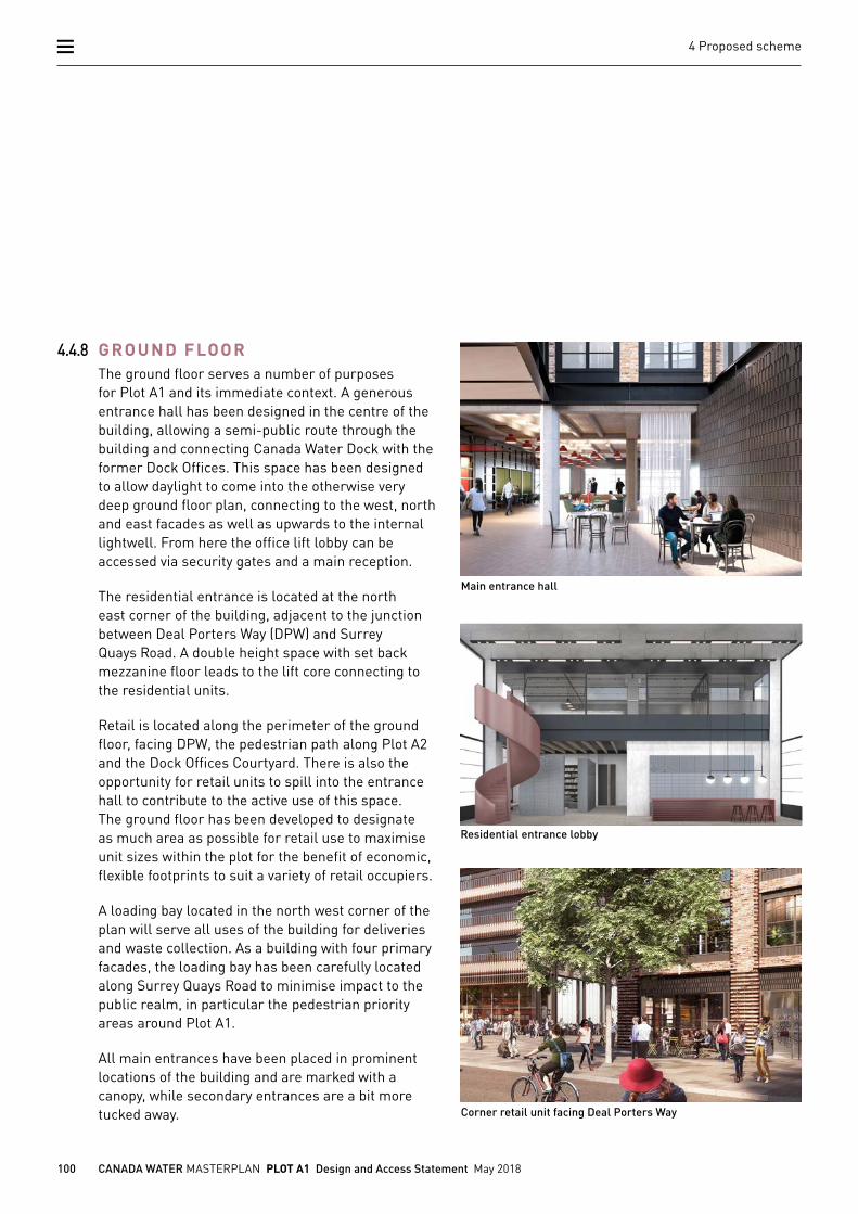
4.4.8 GROUND FLOORThe ground floor serves a number of purposes for Plot A1 and its immediate context. A generous entrance hall has been designed in the centre of the building, allowing a semi-public route through the building and connecting Canada Water Dock with the former Dock Offices. This space has been designed to allow daylight to come into the otherwise very deep ground floor plan, connecting to the west, north and east facades as well as upwards to the internal lightwell. From here the office lift lobby can be accessed via security gates and a main reception.
The residential entrance is located at the north east corner of the building, adjacent to the junction between Deal Porters Way (DPW) and Surrey Quays Road. A double height space with set back mezzanine floor leads to the lift core connecting to the residential units.
Retail is located along the perimeter of the ground floor, facing DPW, the pedestrian path along Plot A2 and the Dock Offices Courtyard. There is also the opportunity for retail units to spill into the entrance hall to contribute to the active use of this space. The ground floor has been developed to designate as much area as possible for retail use to maximise unit sizes within the plot for the benefit of economic, flexible footprints to suit a variety of retail occupiers.
A loading bay located in the north west corner of the plan will serve all uses of the building for deliveries and waste collection. As a building with four primary facades, the loading bay has been carefully located along Surrey Quays Road to minimise impact to the public realm, in particular the pedestrian priority areas around Plot A1.
All main entrances have been placed in prominent locations of the building and are marked with a canopy, while secondary entrances are a bit more tucked away. Corner retail unit facing Deal Porters Way
Main entrance hall
Residential entrance lobby
101 CANADA WATER MASTERPLAN PLOT A1 Design and Access Statement May 2018
4 Proposed scheme
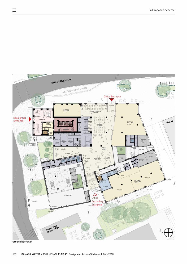
Ground floor plan
N
Office Entrance
Residential Entrance
Office Secondary Entrance

102 CANADA WATER MASTERPLAN PLOT A1 Design and Access Statement May 2018
4 Proposed scheme
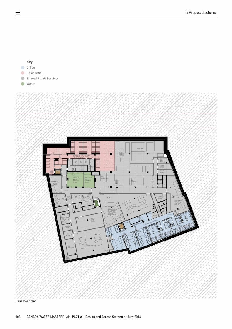
4.4.9 BASEMENTThe Plot A1 basement is a single storey element. It consists of plant areas, residential/ commercial bin stores and residential/commercial support facilities (i.e. cycle storage, changing rooms, lockers).
Due to the LVMF 5 viewing corridor height constraint of 30m AOD, most mechanical plant equipment has been located in the basement. There is no car parking in the basement.
103 CANADA WATER MASTERPLAN PLOT A1 Design and Access Statement May 2018
4 Proposed scheme
Basement plan
KeyOffice
Residential
Shared Plant/Services
Waste
104 CANADA WATER MASTERPLAN PLOT A1 Design and Access Statement May 2018
4 Proposed scheme
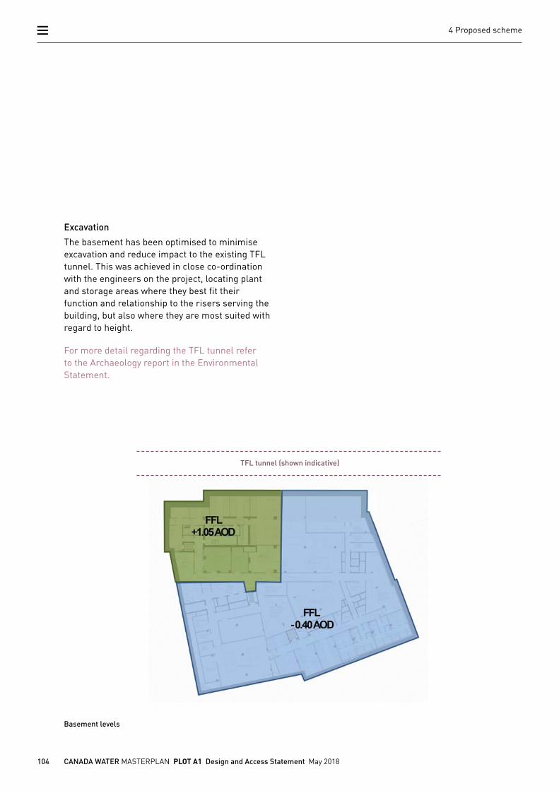
Excavation
The basement has been optimised to minimise excavation and reduce impact to the existing TFL tunnel. This was achieved in close co-ordination with the engineers on the project, locating plant and storage areas where they best fit their function and relationship to the risers serving the building, but also where they are most suited with regard to height.
For more detail regarding the TFL tunnel refer to the Archaeology report in the Environmental Statement.
Basement levels
TFL tunnel (shown indicative)
105 CANADA WATER MASTERPLAN PLOT A1 Design and Access Statement May 2018
4 Proposed scheme
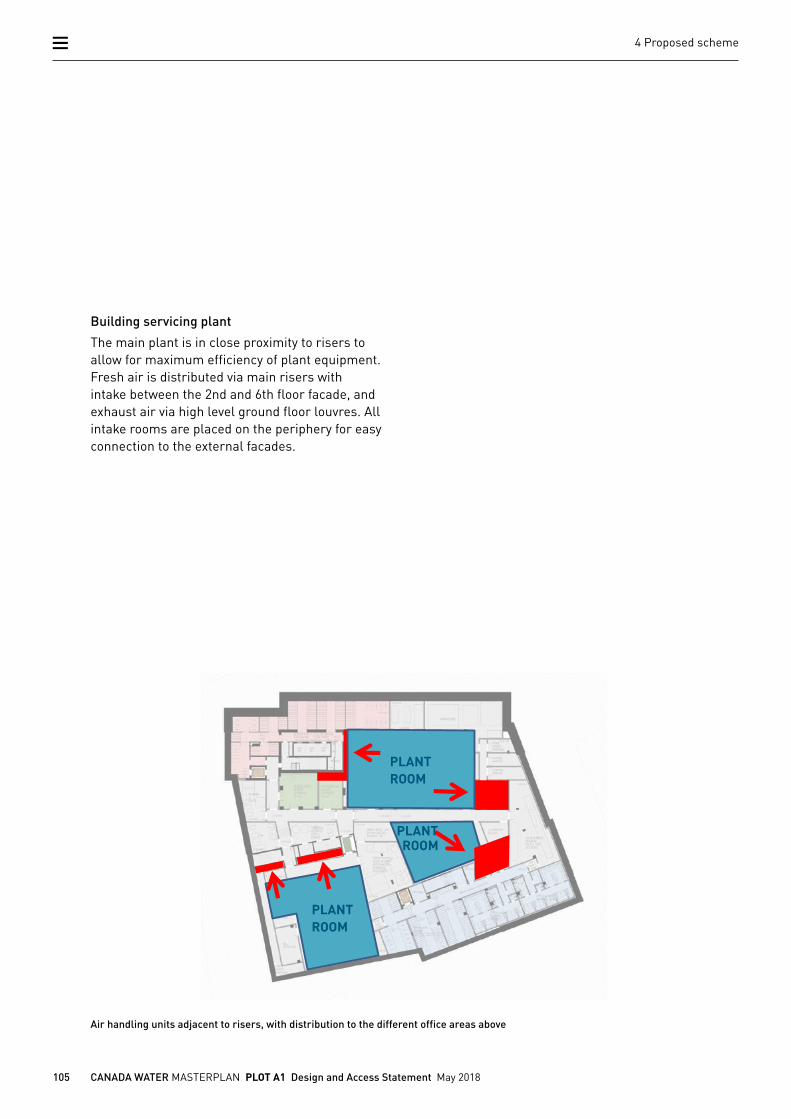
Air handling units adjacent to risers, with distribution to the different office areas above
Building servicing plant
The main plant is in close proximity to risers to allow for maximum efficiency of plant equipment. Fresh air is distributed via main risers with intake between the 2nd and 6th floor facade, and exhaust air via high level ground floor louvres. All intake rooms are placed on the periphery for easy connection to the external facades.
PLANT ROOM
PLANT ROOM
PLANT ROOM
106 CANADA WATER MASTERPLAN PLOT A1 Design and Access Statement May 2018
4 Proposed scheme
0
RESIDENTIAL
OFFICE
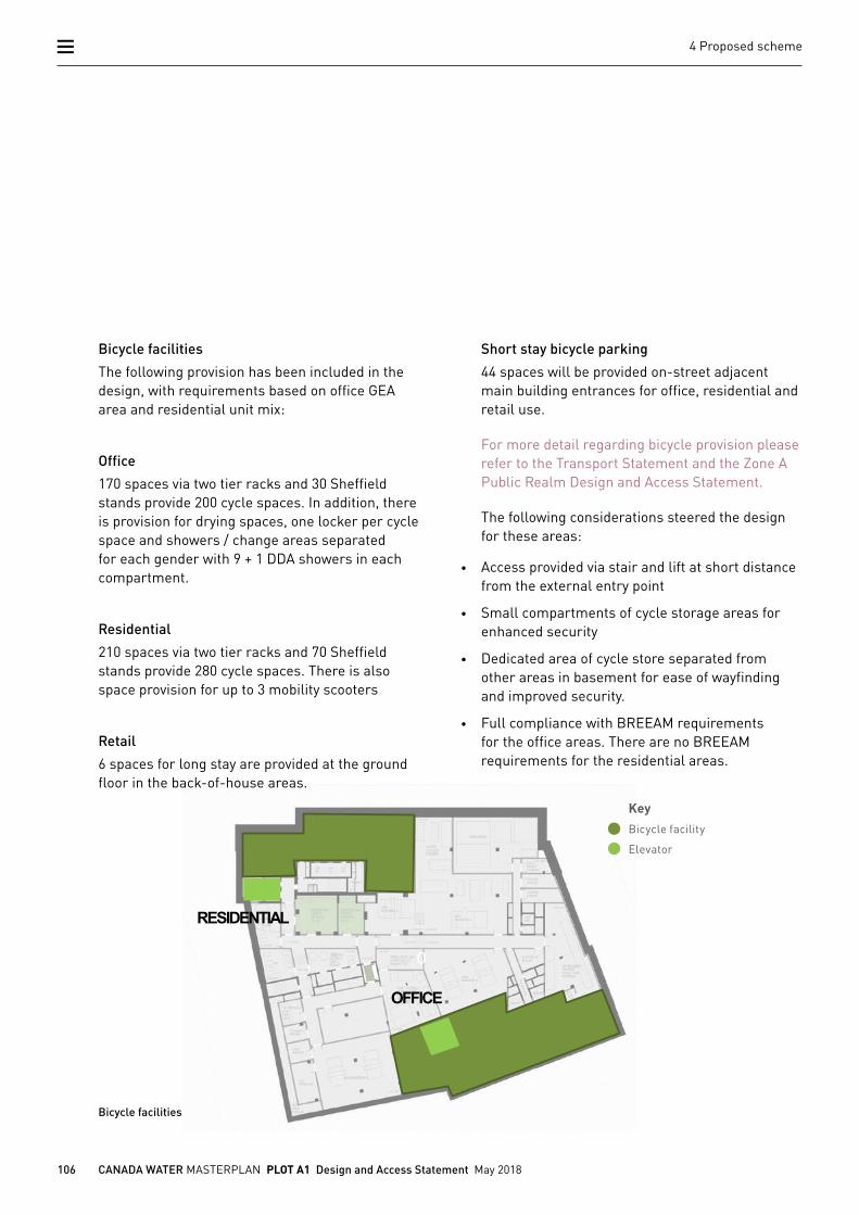
Bicycle facilities
Bicycle facilities
The following provision has been included in the design, with requirements based on office GEA area and residential unit mix:
Office
170 spaces via two tier racks and 30 Sheffield stands provide 200 cycle spaces. In addition, there is provision for drying spaces, one locker per cycle space and showers / change areas separated for each gender with 9 + 1 DDA showers in each compartment.
Residential
210 spaces via two tier racks and 70 Sheffield stands provide 280 cycle spaces. There is also space provision for up to 3 mobility scooters
Retail
6 spaces for long stay are provided at the ground floor in the back-of-house areas.
Short stay bicycle parking
44 spaces will be provided on-street adjacent main building entrances for office, residential and retail use.
For more detail regarding bicycle provision please refer to the Transport Statement and the Zone A Public Realm Design and Access Statement.
The following considerations steered the design for these areas:
• Access provided via stair and lift at short distance from the external entry point
• Small compartments of cycle storage areas for enhanced security
• Dedicated area of cycle store separated from other areas in basement for ease of wayfinding and improved security.
• Full compliance with BREEAM requirements for the office areas. There are no BREEAM requirements for the residential areas.
KeyBicycle facility
Elevator
107 CANADA WATER MASTERPLAN PLOT A1 Design and Access Statement May 2018
4 Proposed scheme
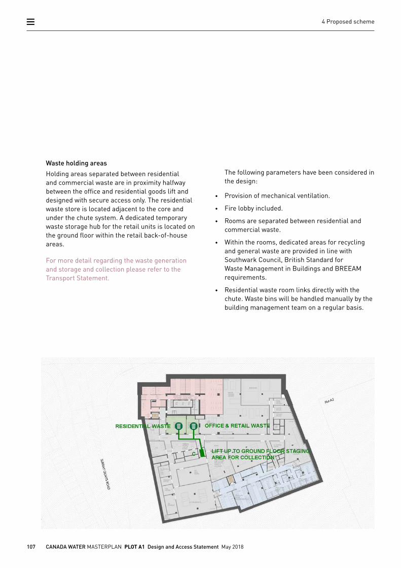
Waste holding areas located at the basement
Waste holding areas
Holding areas separated between residential and commercial waste are in proximity halfway between the office and residential goods lift and designed with secure access only. The residential waste store is located adjacent to the core and under the chute system. A dedicated temporary waste storage hub for the retail units is located on the ground floor within the retail back-of-house areas.
For more detail regarding the waste generation and storage and collection please refer to the Transport Statement.
The following parameters have been considered in the design:
• Provision of mechanical ventilation.
• Fire lobby included.
• Rooms are separated between residential and commercial waste.
• Within the rooms, dedicated areas for recycling and general waste are provided in line with Southwark Council, British Standard for Waste Management in Buildings and BREEAM requirements.
• Residential waste room links directly with the chute. Waste bins will be handled manually by the building management team on a regular basis.
108 CANADA WATER MASTERPLAN PLOT A1 Design and Access Statement May 2018
4 Proposed scheme
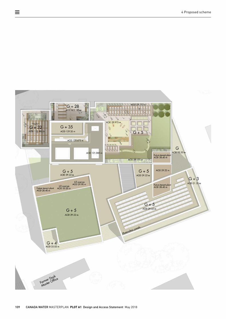
4.4.10 ROOFS Creating a family of building results in a number of different roofs at different levels. The largest footprint of the proposal terminates at 6th floor, where three roofs top the three office buildings. The block fronting Canada Water provides the greater part of communal amenity for the residents of the development. Access is granted via the residential core.
The roofs of the other two office buildings have been predominantly designed to accommodate measures to improve the sustainable ambitions of the project in form of solar panels towards the south, and a sedum roof toward the north with a small allowance for tenant future plant provision. All equipment on the roof including lift overruns will be below the parapet line, or set back sufficiently not to be visible from the streetscape.
The roofs of the three towers house further communal amenity uses on floor 29 and 32, which are protected from wind with a glass screen and pergola structures. The tallest tower holds the lift overruns, small areas of mechanical plant and a BMU. A patterned screen with small perforations hides all plant equipment and the BMU from view.
109 CANADA WATER MASTERPLAN PLOT A1 Design and Access Statement May 2018
4 Proposed scheme
110 CANADA WATER MASTERPLAN PLOT A1 Design and Access Statement May 2018
4 Proposed scheme
4.5 Appearance
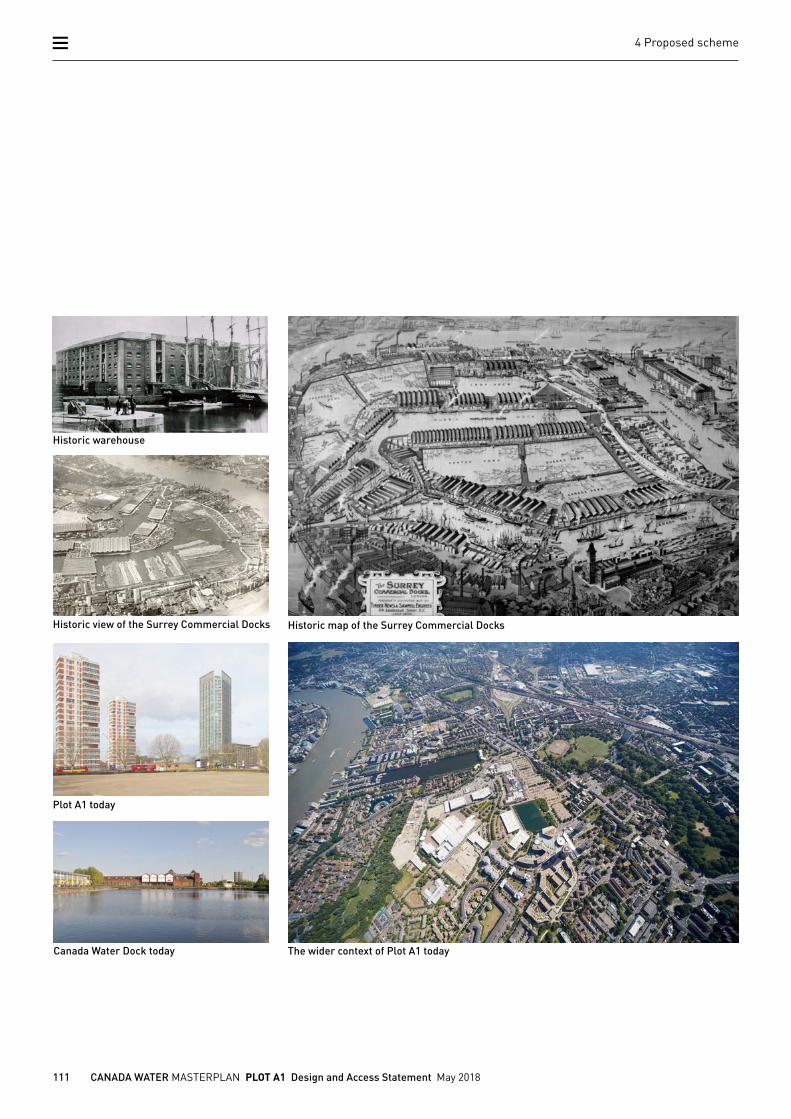
Typology
Typologically, the area is characterised by low-rise housing estates, mid-rise office and residential blocks, converted old warehouses and residential high-rise buildings which date back to the early 1960s. Industrial warehouses dominate the south-east side of the Dock, while new multi storey housing blocks are emerging in the north east.
The design for Plot A1 adopts two of these typologies: the old warehouse and the tower. Both building types are characterised by the use of structural systems, creating deep plans with large spans and floors stacked to impressive heights.
References for Plot A1 are derived from the long-gone warehouses of the docklands for the low rise office buildings; the high-rise block finds its oldest precedent in the adjacent Canada Estate towers from the early 1960s. Both references form a reinterpretation of two existing typologies within one development to serve different uses.
This chapter explains Plot A1 in its context regarding its appearance, relevant typologies, materiality and colour.
111 CANADA WATER MASTERPLAN PLOT A1 Design and Access Statement May 2018
4 Proposed scheme
Historic view of the Surrey Commercial Docks
Canada Water Dock today
Historic warehouse
Historic map of the Surrey Commercial Docks
Plot A1 today
The wider context of Plot A1 today
112 CANADA WATER MASTERPLAN PLOT A1 Design and Access Statement May 2018
4 Proposed scheme
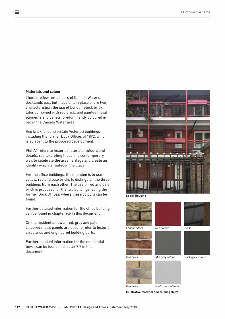
Materials and colour
There are few remainders of Canada Water’s docklands past but those still in place share two characteristics: the use of London Stock brick, later combined with red brick, and painted metal elements and panels, predominantly coloured in red in the Canada Water area.
Red brick is found on late Victorian buildings including the former Dock Offices of 1892, which is adjacent to the proposed development.
Plot A1 refers to historic materials, colours and details, reinterpreting these in a contemporary way, to celebrate the area heritage and create an identity which is rooted in the place.
For the office buildings, the intention is to use yellow, red and pale bricks to distinguish the three buildings from each other. The use of red and pale brick is proposed for the two buildings facing the former Dock Offices, where these colours can be found.
Further detailed information for the office building can be found in chapter 6.6 in this document.
On the residential tower, red, grey and pale coloured metal panels are used to refer to historic structures and engineered building parts.
Further detailed information for the residential tower can be found in chapter 7.7 in this document.
Social Housing
London Stock
Red brick
Pale brick
Red colour
Mid grey colour
light coloured tone
Dark grey colour
Glass
Illustrative material and colour palette
113 CANADA WATER MASTERPLAN PLOT A1 Design and Access Statement May 2018
4 Proposed scheme
Redriff Road Bridge
Rotherhithe Street Bascule Bridge
Gasometer
Thames Tunnel Mill
114 CANADA WATER MASTERPLAN PLOT A1 Design and Access Statement May 2018
4 Proposed scheme
Former Dock Offices
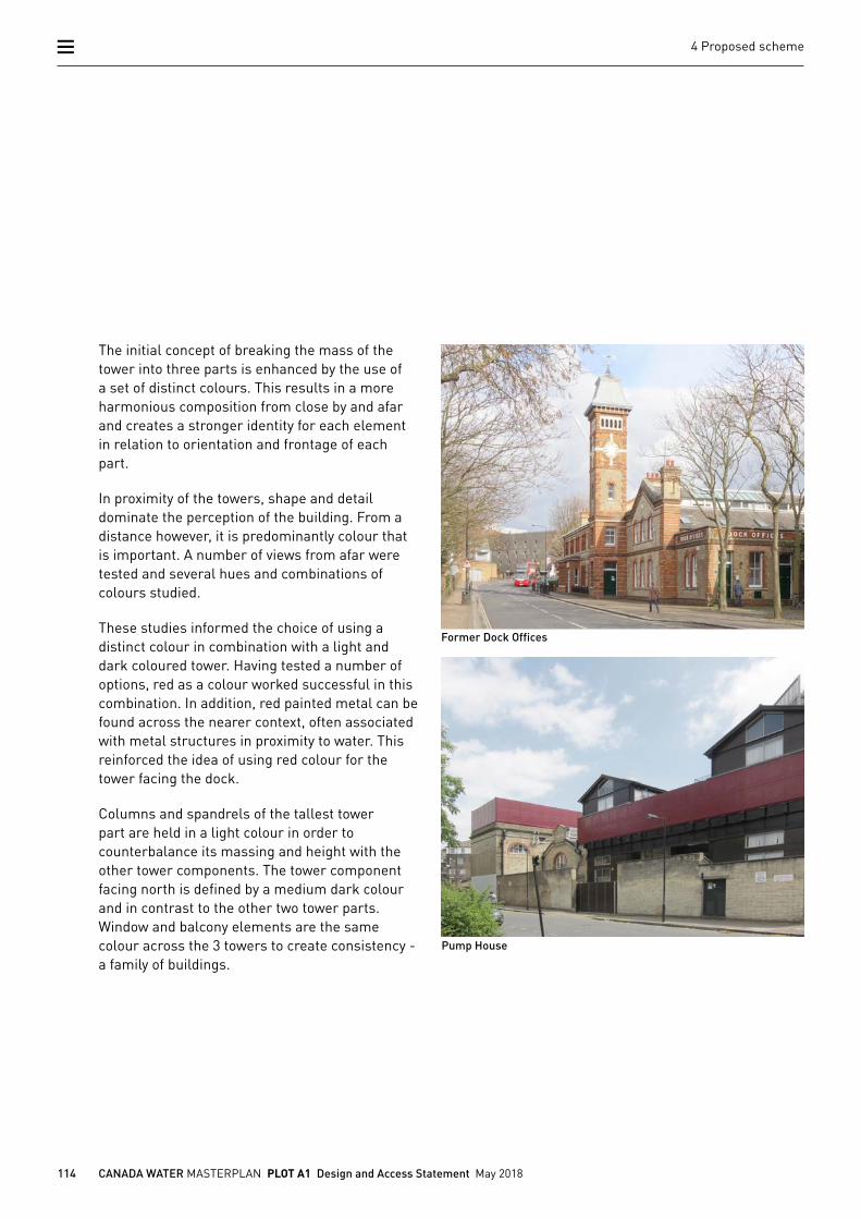
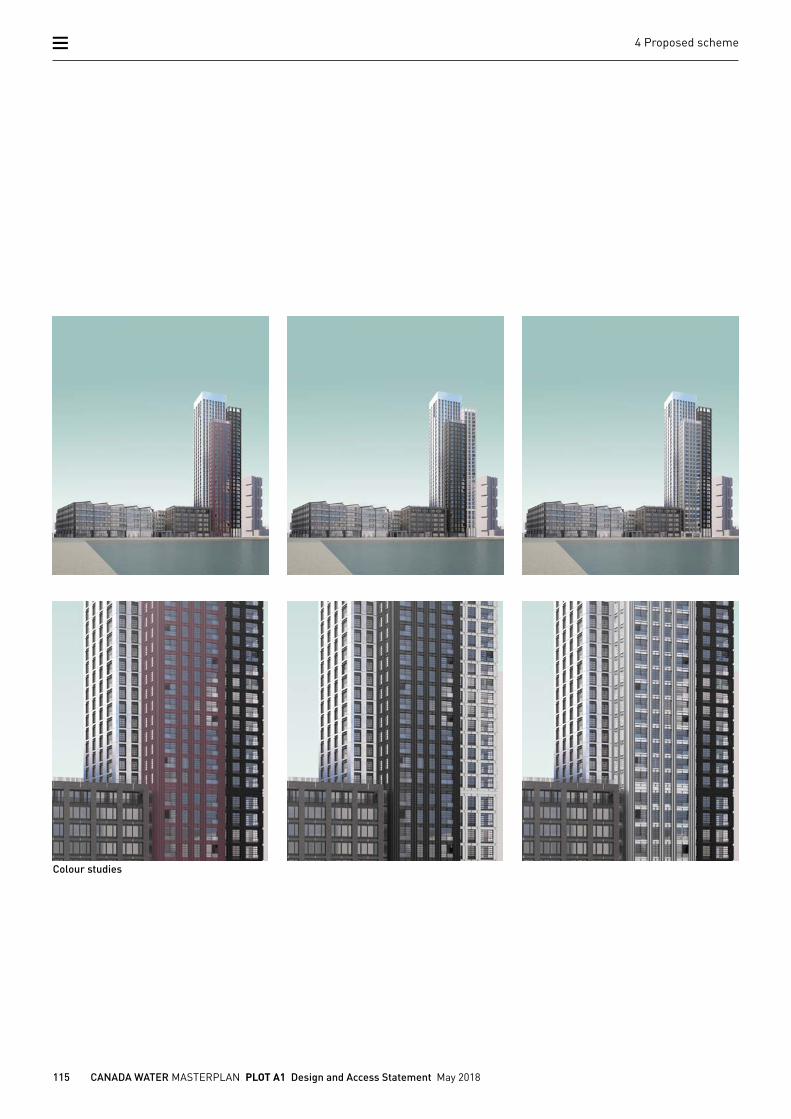
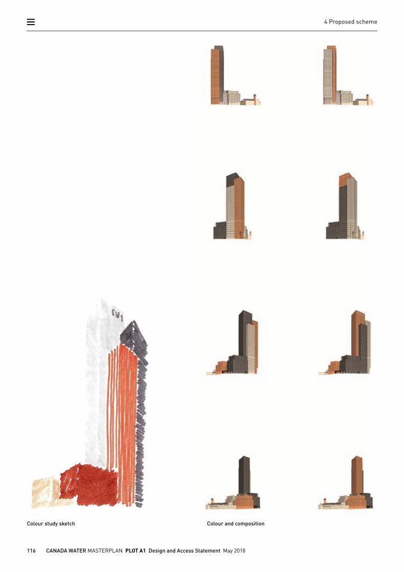
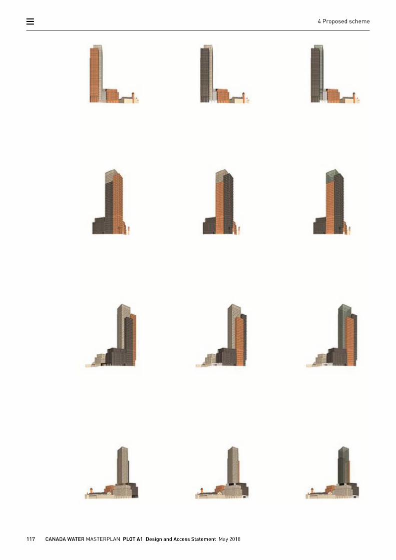
The initial concept of breaking the mass of the tower into three parts is enhanced by the use of a set of distinct colours. This results in a more harmonious composition from close by and afar and creates a stronger identity for each element in relation to orientation and frontage of each part.
In proximity of the towers, shape and detail dominate the perception of the building. From a distance however, it is predominantly colour that is important. A number of views from afar were tested and several hues and combinations of colours studied.
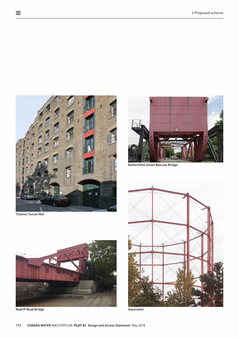
These studies informed the choice of using a distinct colour in combination with a light and dark coloured tower. Having tested a number of options, red as a colour worked successful in this combination. In addition, red painted metal can be found across the nearer context, often associated with metal structures in proximity to water. This reinforced the idea of using red colour for the tower facing the dock.
Columns and spandrels of the tallest tower part are held in a light colour in order to counterbalance its massing and height with the other tower components. The tower component facing north is defined by a medium dark colour and in contrast to the other two tower parts. Window and balcony elements are the same colour across the 3 towers to create consistency - a family of buildings.
Pump House
115 CANADA WATER MASTERPLAN PLOT A1 Design and Access Statement May 2018
4 Proposed scheme
Colour studies
116 CANADA WATER MASTERPLAN PLOT A1 Design and Access Statement May 2018
4 Proposed scheme
Colour and compositionColour study sketch
117 CANADA WATER MASTERPLAN PLOT A1 Design and Access Statement May 2018
4 Proposed scheme
118 CANADA WATER MASTERPLAN PLOT A1 Design and Access Statement May 2018
4 Proposed scheme
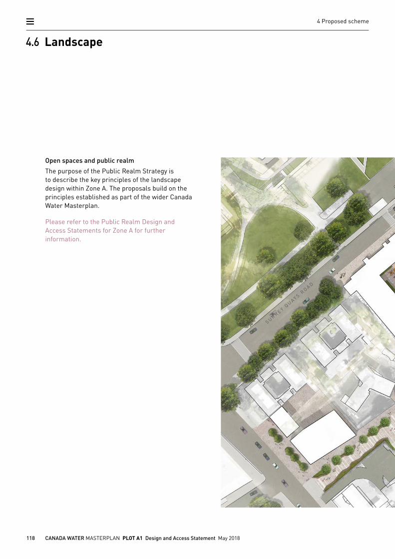
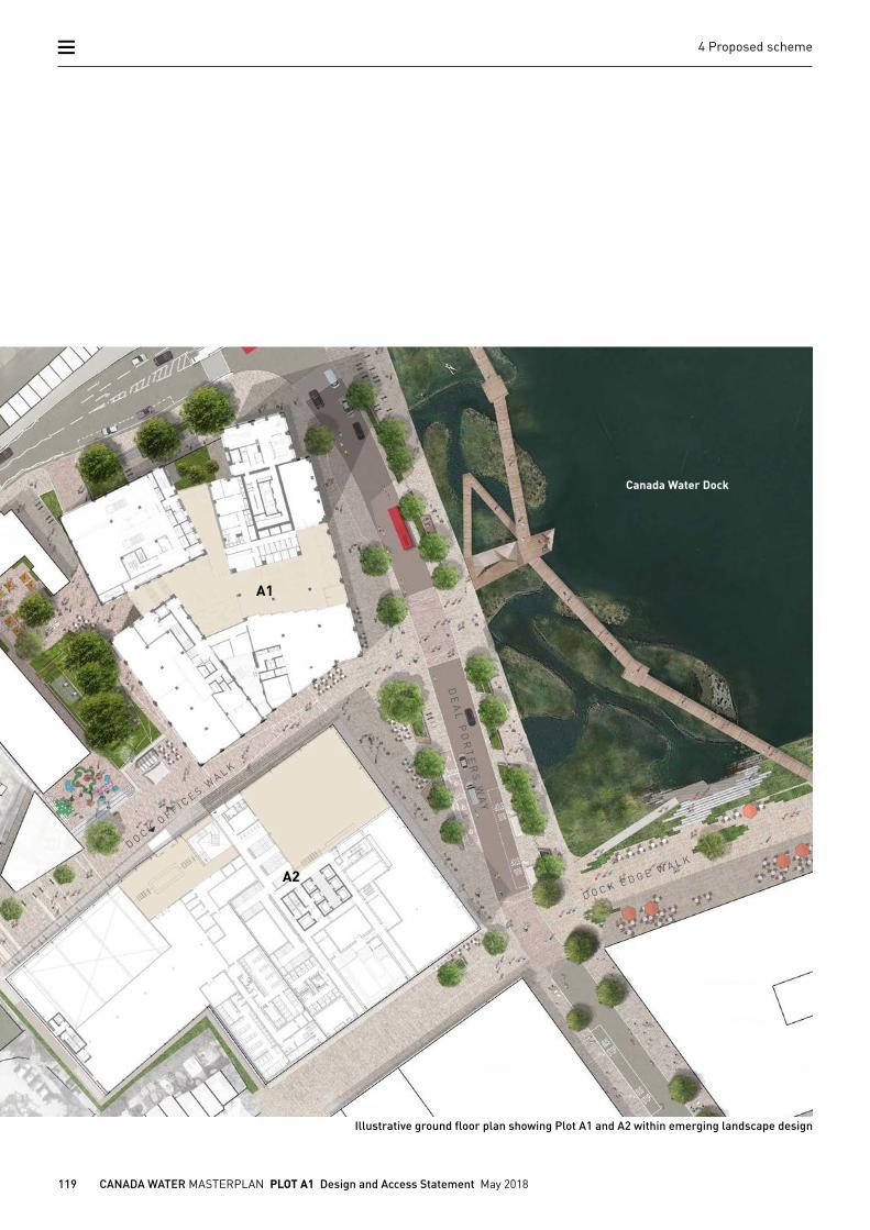
Open spaces and public realm
The purpose of the Public Realm Strategy is to describe the key principles of the landscape design within Zone A. The proposals build on the principles established as part of the wider Canada Water Masterplan.
Please refer to the Public Realm Design and Access Statements for Zone A for further information.
4.6 Landscape
S U R R E Y QU AY S R
O A D
119 CANADA WATER MASTERPLAN PLOT A1 Design and Access Statement May 2018
4 Proposed scheme
Illustrative ground floor plan showing Plot A1 and A2 within emerging landscape design
A1
Canada Water Dock
A2
DE
AL
PO
RT
ER
S W
AY
D O C K OF F I C E S W
A L K
D O C K E D G E W A L K
120 CANADA WATER MASTERPLAN PLOT A1 Design and Access Statement May 2018
4 Proposed scheme
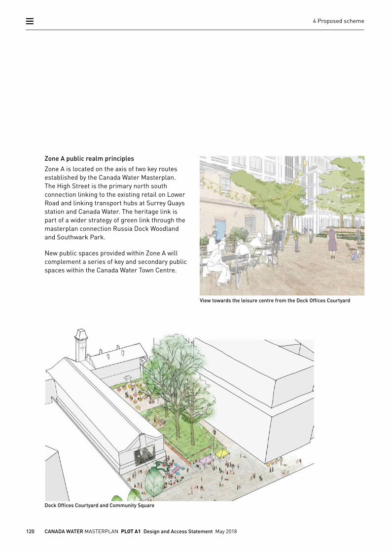
Zone A public realm principles
Zone A is located on the axis of two key routes established by the Canada Water Masterplan. The High Street is the primary north south connection linking to the existing retail on Lower Road and linking transport hubs at Surrey Quays station and Canada Water. The heritage link is part of a wider strategy of green link through the masterplan connection Russia Dock Woodland and Southwark Park.
New public spaces provided within Zone A will complement a series of key and secondary public spaces within the Canada Water Town Centre.
View towards the leisure centre from the Dock Offices Courtyard
Dock Offices Courtyard and Community Square
121 CANADA WATER MASTERPLAN PLOT A1 Design and Access Statement May 2018
4 Proposed scheme
View north towards Canada Water library View west into the community square
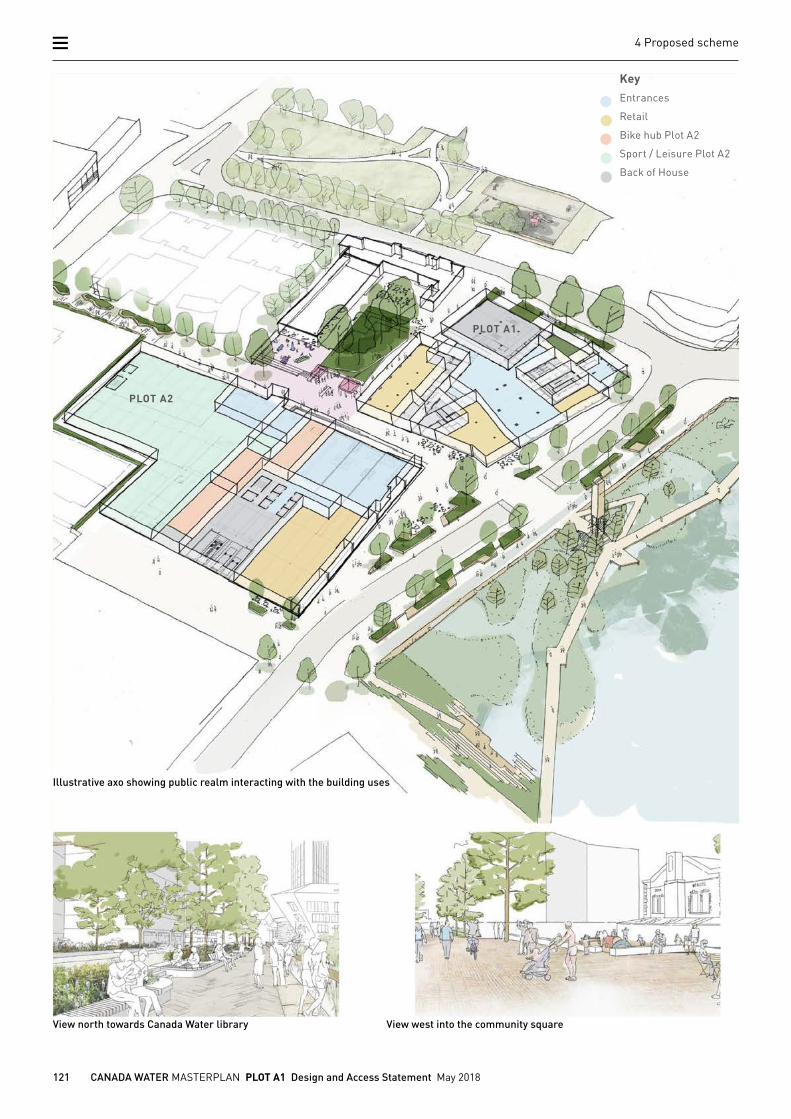
Illustrative axo showing public realm interacting with the building uses
PLOT A2
PLOT A1
KeyEntrances
Retail
Bike hub Plot A2
Sport / Leisure Plot A2
Back of House
122 CANADA WATER MASTERPLAN PLOT A1 Design and Access Statement May 2018
4 Proposed scheme
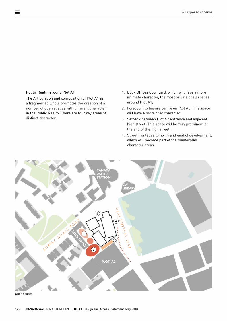
Public Realm around Plot A1
The Articulation and composition of Plot A1 as a fragmented whole promotes the creation of a number of open spaces with different character in the Public Realm. There are four key areas of distinct character:
CW LIBRARY
PLOT A2
CANADA WATER STATION
Open spaces
1. Dock Offices Courtyard, which will have a more intimate character, the most private of all spaces around Plot A1;
2. Forecourt to leisure centre on Plot A2. This space will have a more civic character;
3. Setback between Plot A2 entrance and adjacent high street. This space will be very prominent at the end of the high street;
4. Street frontages to north and east of development, which will become part of the masterplan character areas.
1
2
3
4
4
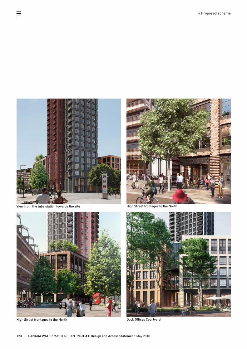
123 CANADA WATER MASTERPLAN PLOT A1 Design and Access Statement May 2018
4 Proposed scheme
High Street frontages to the North
View from the tube station towards the site
Dock Offices Courtyard
High Street frontages to the North
124 CANADA WATER MASTERPLAN PLOT A1 Design and Access Statement May 2018
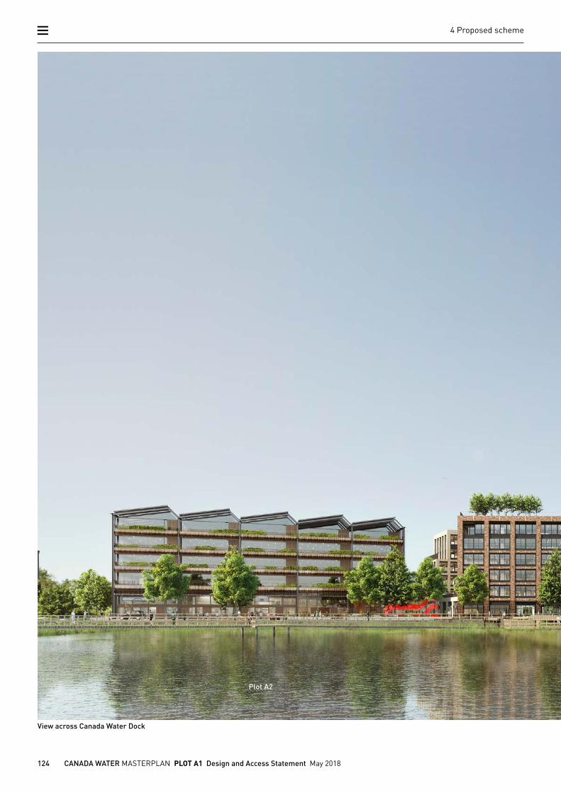
4 Proposed scheme
View across Canada Water Dock
Plot A2
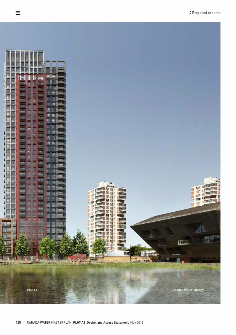
125 CANADA WATER MASTERPLAN PLOT A1 Design and Access Statement May 2018
4 Proposed scheme
Plot A1 Canada Water Library


End of Part 4 of 9