Embed Size (px)
Citation preview

C O U N T Y T R A I L S P R O G R A M
C O M M U N I T Y T R A I L S M A S T E R P L A N
SECTION
7
Design and Construction Guidelines Trail Design Guidelines
n this document the term “Trails” is used as a general term, which covers both trails and pathways unless
otherwise noted. These guidelines apply to both trails and pathways.
This section discusses considerations and guidelines for general trail development. The trail development guidelines will be used to:
Provide trail design continuity
Provide trail user safety and convenience
Minimize trail hazards, deterioration and liability
Minimize trail operations and maintenance costs
Protect open space, natural, cultural and historic resources
This section also provides guidance for development projects to:
Increase recreational opportunities
Provide trail connectivity, variety of user experiences and non-motorized transportation opportunities
These guidelines were established as an “optimal” condition intended for typical application countywide.
In the County of San Diego trail development which includes trail improvements is necessary because of the unmet trail demand (need) and trail connectivity. The process of developing a trail includes a number of complex steps
I
Design and Construction Guidelines 77
C O U N T Y T R A I L S P R O G R A M
C O M M U N I T Y T R A I L S M A S T E R P L A N
including planning, design, alignment, environmental review, clearing, grading, and construction of special structures. In conjunction with the course of physical trail development, procedural actions must also occur, such as establishing which sections of trail have construction priority, confirming a legal transfer of land if necessary, receiving the approval from multiple review boards to complete the process, and the bid process for choosing trail designers and contractors.
The guidelines are meant to be as thorough as possible, however, it is difficult to cover every situation and flexibility will be necessary. Specific site conditions must be evaluated and proper design guidelines applied to those conditions. If site conditions prohibit, or otherwise prevent general conformance with the Countywide Trail Design Guidelines, it will not prohibit or prevent the development of the trail if approved by the County Trail Manager. These guidelines are not “absolutes” and do not replace any existing codes, rules or regulations of land managing and permitting agencies that may govern trail development (i.e. state or federal agencies), but are in addition to them (see Jurisdictional Coordination). Necessary permits from these agencies will be obtained when trail alignments result in impacts to their jurisdictional areas.
The Trail Design Guidelines specifically apply to all of the County of San Diego departments and staff as well as private developers. Where references are made to
cities or special districts, these guidelines are intended to be a model and point-of-reference for those entities. They are encouraged to reference and/or make-use of these guidelines, where appropriate, as part of their own trails planning efforts.
These trail development guidelines complement the County Trails Program (CTP) goals, policies and implementation strategies by identifying:
The need for greater definition concerning the characteristics, use and safety measures associated with countywide trails definitions that provide a level of understanding to trail users and property owners whose lands lie adjacent to countywide trails.
How a specific trail route should be sited and designed based on a series of common trail conditions and landscape circumstances found in San Diego County; and
Additional community specific guidelines for each CPSG (see CPSG section of CTMP) will supplement countywide guidelines where applicable. New or improved trail route will be evaluated on a case-by-case basis, taking into account existing field conditions, trail routes and land use relationships.
Design and Construction Guidelines 78
C O U N T Y T R A I L S P R O G R A M
C O M M U N I T Y T R A I L S M A S T E R P L A N
Design and Construction Guidelines 79
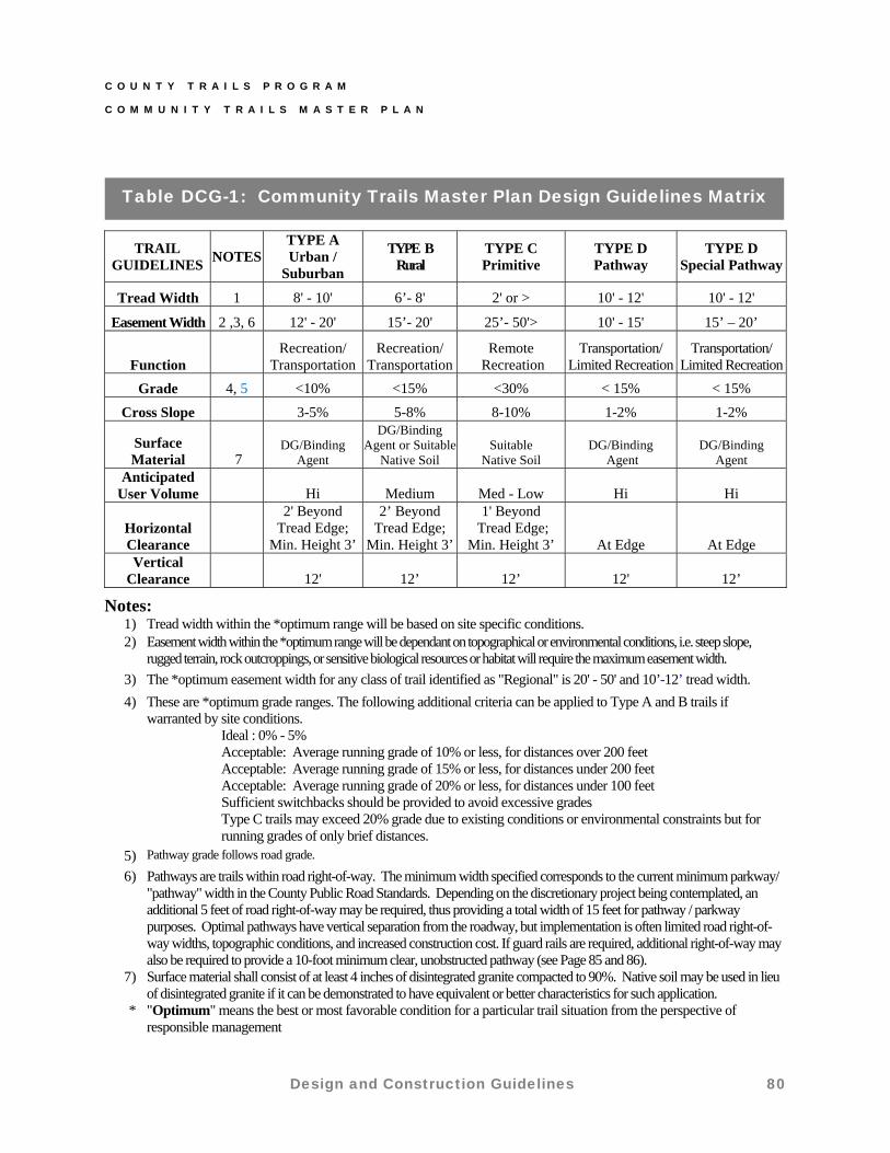
A simplified approach to trail classification was developed because of the sheer size of the County of San Diego and the desire to provide guidelines, rather than rigid standards. This approach resulted in a classification of three trail types A, B, C, and two pathway types D and D-Special (Table DCG-1 and Figures DG-1 through DG-5). These trail types and their associated optimal design guidelines will be utilized in the CTMP.
Regional and community trails classified as A, B, C, and D will be multi-use and accessible to all non-motorized users including equestrian, mountain bicyclists, and pedestrians. Each type has optimum guidelines such as easement, tread width, grade, and clearance that will influence construction and maintenance of trails. When conducting repair or maintenance activities on existing trails, reasonable efforts will be made to bring the trail into conformance with these guidelines.
All trails should have design guidelines established for tread width, easement width, function, cross slope, grade, anticipated user volume, horizontal clearance, and vertical clearance as well as adequate signage, fencing, staging areas and additional trail features.
The objective of the design guidelines is to be efficient, effective, and feasible with respect to
initiating, implementing and managing trails while attempting to satisfy the greatest number of users with the least amount of acquisition and construction cost per user. The placement of trails into these classifications allows a County manager to assign appropriate and optimal guidelines, funding, and work responsibility to each community’s trails system.
7.1 Trail Types
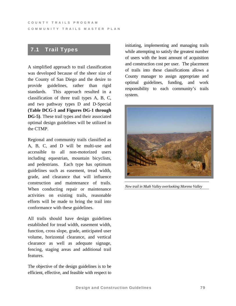
New trail in Muth Valley overlooking Moreno Valley
C O U N T Y T R A I L S P R O G R A M
C O M M U N I T Y T R A I L S M A S T E R P L A N
Table DCG-1: Community Trails Master Plan Design Guidelines Matrix
TRAIL GUIDELINES
NOTES TYPE A Urban /
Suburban
TYPE B Rural
TYPE C Primitive
TYPE D Pathway
TYPE D Special Pathway
Tread Width 1 8' - 10' 6’- 8' 2' or > 10' - 12' 10' - 12'
Easement Width 2 ,3, 6 12' - 20' 15’- 20' 25’- 50'> 10' - 15' 15’ – 20’
Function Recreation/
Transportation Recreation/
TransportationRemote
Recreation Transportation/
Limited Recreation Transportation/
Limited Recreation
Grade 4, 5 <10% <15% <30% < 15% < 15%
Cross Slope 3-5% 5-8% 8-10% 1-2% 1-2%
Surface Material 7
DG/Binding Agent
DG/Binding Agent or Suitable
Native Soil Suitable
Native Soil DG/Binding
Agent DG/Binding
Agent Anticipated
User Volume Hi Medium Med - Low Hi Hi
Horizontal Clearance
2' Beyond Tread Edge;
Min. Height 3’
2’ Beyond Tread Edge;
Min. Height 3’
1' Beyond Tread Edge;
Min. Height 3’ At Edge At Edge Vertical
Clearance 12' 12’ 12’ 12' 12’
Notes:
1) Tread width within the *optimum range will be based on site specific conditions. 2) Easement width within the *optimum range will be dependant on topographical or environmental conditions, i.e. steep slope,
rugged terrain, rock outcroppings, or sensitive biological resources or habitat will require the maximum easement width.
3) The *optimum easement width for any class of trail identified as "Regional" is 20' - 50' and 10’-12’ tread width.
4) These are *optimum grade ranges. The following additional criteria can be applied to Type A and B trails if warranted by site conditions. Ideal : 0% - 5% Acceptable: Average running grade of 10% or less, for distances over 200 feet Acceptable: Average running grade of 15% or less, for distances under 200 feet Acceptable: Average running grade of 20% or less, for distances under 100 feet Sufficient switchbacks should be provided to avoid excessive grades Type C trails may exceed 20% grade due to existing conditions or environmental constraints but for
running grades of only brief distances. 5) Pathway grade follows road grade.
6) Pathways are trails within road right-of-way. The minimum width specified corresponds to the current minimum parkway/ "pathway" width in the County Public Road Standards. Depending on the discretionary project being contemplated, an additional 5 feet of road right-of-way may be required, thus providing a total width of 15 feet for pathway / parkway purposes. Optimal pathways have vertical separation from the roadway, but implementation is often limited road right-of-way widths, topographic conditions, and increased construction cost. If guard rails are required, additional right-of-way may also be required to provide a 10-foot minimum clear, unobstructed pathway (see Page 85 and 86).
7) Surface material shall consist of at least 4 inches of disintegrated granite compacted to 90%. Native soil may be used in lieu of disintegrated granite if it can be demonstrated to have equivalent or better characteristics for such application.
* "Optimum" means the best or most favorable condition for a particular trail situation from the perspective of responsible management
Design and Construction Guidelines 80

C O U N T Y T R A I L S P R O G R A M
C O M M U N I T Y T R A I L S M A S T E R P L A N
TYPE A – URBAN / SUBURBAN TRAIL
Trail type intended for an intense volume of use generally associated within an
urban/suburban setting. These trails provide the widest tread so they may function as
both recreation and transportation facilities and will be accessible to all trail users.
3% - 5%
FIGURE DG-1
Design and Construction Guidelines 81
C O U N T Y T R A I L S P R O G R A M
C O M M U N I T Y T R A I L S M A S T E R P L A N
Design and Construction Guidelines 82
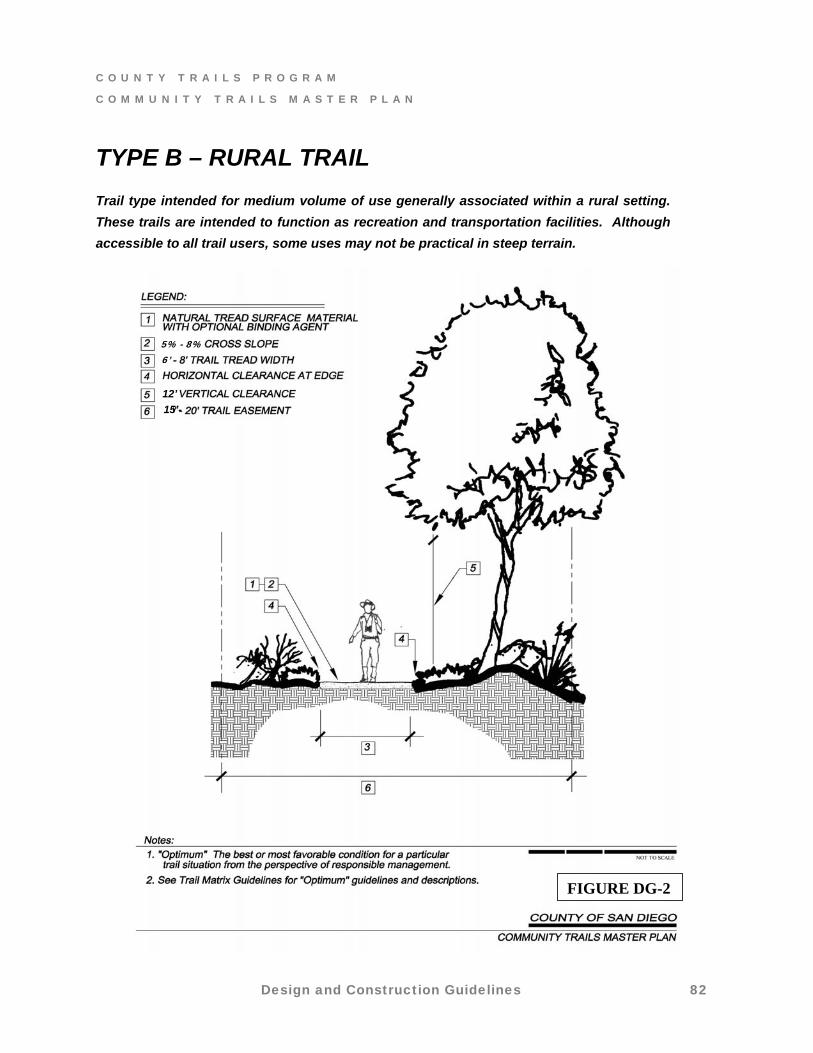
TYPE B – RURAL TRAIL
Trail type intended for medium volume of use generally associated within a rural setting.
These trails are intended to function as recreation and transportation facilities. Although
accessible to all trail users, some uses may not be practical in steep terrain.
5% - 8%
6’
12’
15’-
FIGURE DG-2
C O U N T Y T R A I L S P R O G R A M
C O M M U N I T Y T R A I L S M A S T E R P L A N
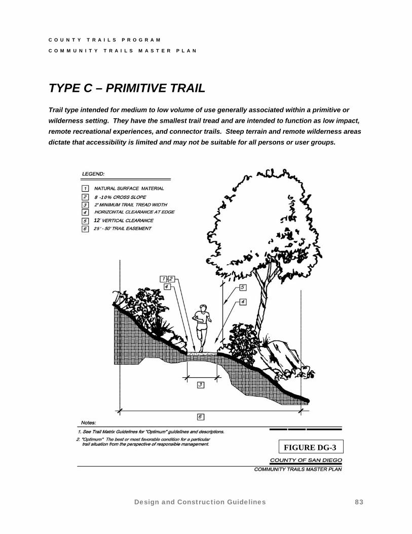
TYPE C – PRIMITIVE TRAIL
Trail type intended for medium to low volume of use generally associated within a primitive or
wilderness setting. They have the smallest trail tread and are intended to function as low impact,
remote recreational experiences, and connector trails. Steep terrain and remote wilderness areas
dictate that accessibility is limited and may not be suitable for all persons or user groups.
8 -10%
1 ’ 2 25’
FIGURE DG-3
Design and Construction Guidelines 83
C O U N T Y T R A I L S P R O G R A M
C O M M U N I T Y T R A I L S M A S T E R P L A N
The Department of Public Works (DPW) oversees the implementation, management, and maintenance of existing and newly developed pathways. On private development projects that impact pathways identified in the Board approved Regional Trails Map (County General Plan, Public Facilities Element) or Community Trails Master Plan, DPW requires dedication and improvement of the pathway. The dedication of a pathway includes an additional five feet (or more) of public road right-of-way on one side of the road. DPW ensures that pathway dedication and improvement requirements comply with the County’s Public Road Standards and Pathway Design Guidelines contained in the CTMP.
When the pathway is constructed as part of a development project, DPW conducts inspection activities to assure conformance with County standards and the adopted Resolution of Approval for the project. Once DPW issues final inspection compliance and project recordation occurs, the pathway is considered “designated” or official.
On public improvement projects impacting Board approved pathways, DPW assures that adequate additional right-of-way and pathway improvements are included in the project design and construction. Typical public projects include road widening, major road improvements, bridge construction, or flood control facilities within public road
right-of-way. For these kinds of projects, DPW is responsible for preliminary engineering, and subsequent phases of design and construction.
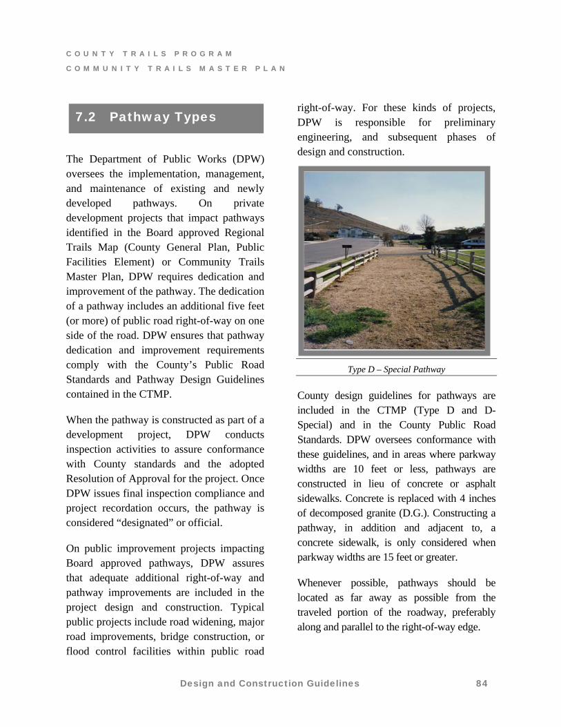
7.2 Pathway Types
Type D – Special Pathway
County design guidelines for pathways are included in the CTMP (Type D and D-Special) and in the County Public Road Standards. DPW oversees conformance with these guidelines, and in areas where parkway widths are 10 feet or less, pathways are constructed in lieu of concrete or asphalt sidewalks. Concrete is replaced with 4 inches of decomposed granite (D.G.). Constructing a pathway, in addition and adjacent to, a concrete sidewalk, is only considered when parkway widths are 15 feet or greater.
Whenever possible, pathways should be located as far away as possible from the traveled portion of the roadway, preferably along and parallel to the right-of-way edge.
Design and Construction Guidelines 84
C O U N T Y T R A I L S P R O G R A M
C O M M U N I T Y T R A I L S M A S T E R P L A N
Pathway Encroachments
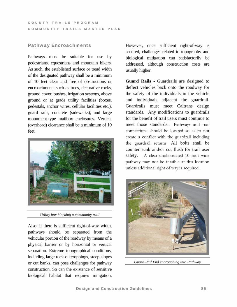
Pathways must be suitable for use by pedestrians, equestrians and mountain bikers. As such, the established surface or tread width of the designated pathway shall be a minimum of 10 feet clear and free of obstructions or encroachments such as trees, decorative rocks, ground cover, bushes, irrigation systems, above ground or at grade utility facilities (boxes, pedestals, anchor wires, cellular facilities etc.), guard rails, concrete (sidewalks), and large monument-type mailbox enclosures. Vertical (overhead) clearance shall be a minimum of 10 feet.
Utility box blocking a community trail
Also, if there is sufficient right-of-way width, pathways should be separated from the vehicular portion of the roadway by means of a physical barrier or by horizontal or vertical separation. Extreme topographical conditions, including large rock outcroppings, steep slopes or cut banks, can pose challenges for pathway construction. So can the existence of sensitive biological habitat that requires mitigation.
However, once sufficient right-of-way is secured, challenges related to topography and biological mitigation can satisfactorily be addressed, although construction costs are usually higher.
Guard Rails - Guardrails are designed to deflect vehicles back onto the roadway for the safety of the individuals in the vehicle and individuals adjacent the guardrail. Guardrails must meet Caltrans design standards. Any modifications to guardrails for the benefit of trail users must continue to meet those standards. Pathways and trail connections should be located so as to not create a conflict with the guardrail including the guardrail returns. All bolts shall be counter sunk and/or cut flush for trail user safety. A clear unobstructed 10 foot wide pathway may not be feasible at this location unless additional right of way is acquired.
Guard Rail End encroaching into Pathway
Design and Construction Guidelines 85
C O U N T Y T R A I L S P R O G R A M
C O M M U N I T Y T R A I L S M A S T E R P L A N
Design and Construction Guidelines 86
Pathways with the following features may require a fencing material, acceptable to the Director of Public Works, to be installed along the right-of-way boundary:
The pathway is adjacent to down slope gradients of 1.5 horizontal to 1.0 vertical or greater, and
There is a vertical differential of at least 5 feet, and
The vertical differential continues parallel along the pathway for a distance greater than or equal to 30 feet.
Pathway Markers/Signs - Depending on site-specific conditions, the Director may require the installation of reflective delineators (pathway markers) bearing a County trail decal along the right-of-way boundary. If required, markers will be placed at an equal distance from the face of curb and spaced at 300 foot intervals, unless specified otherwise.
Road way signs such as speed limits, warnings or reflectors should be placed so there is little interference with the pathway as possible. The placement of traffic signs must continue to meet standards as set forth in the Manual of Uniform Traffic Control Devices (MUTCD) and/or CalTrans specifications. Pathways and trail connections should be located so as to not create a conflict with traffic signs. A clear unobstructed 10 foot wide pathway may not be feasible at this location unless additional right of way is acquired.
The height of signs and their relative location to the pathway could be a safety hazard for equestrians. Additional right of way may be necessary to ensure safe passage.
C O U N T Y T R A I L S P R O G R A M
C O M M U N I T Y T R A I L S M A S T E R P L A N
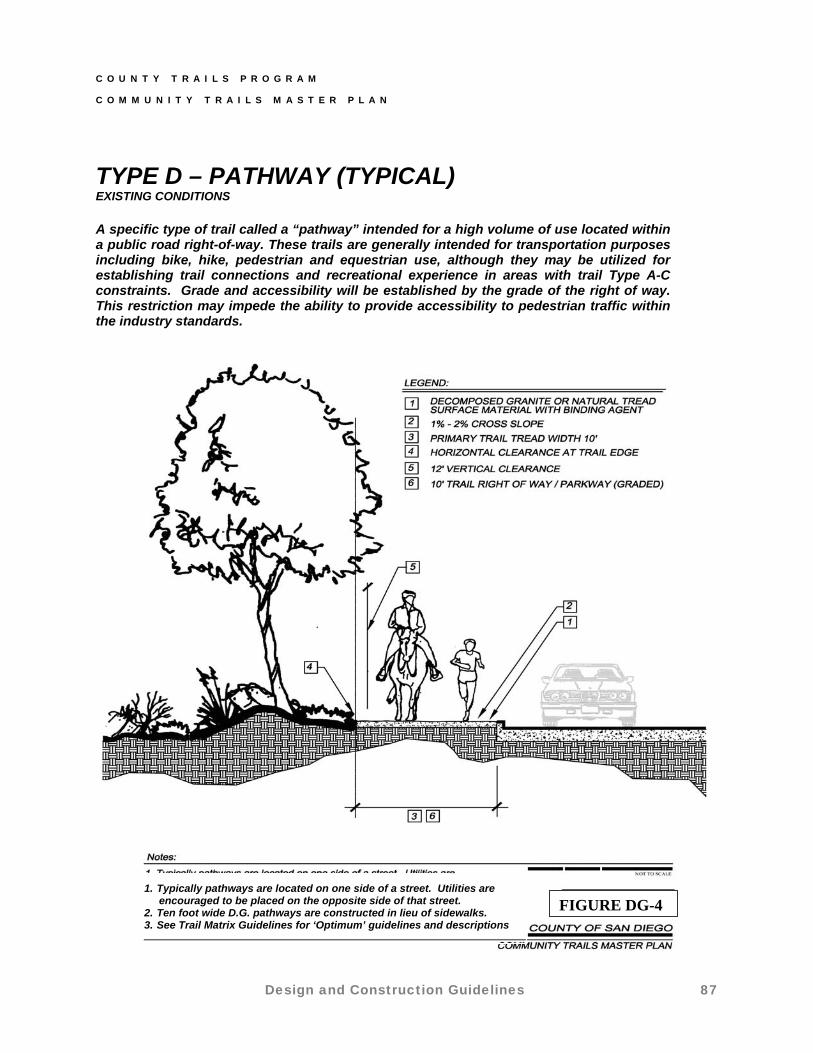
TYPE D – PATHWAY (TYPICAL) EXISTING CONDITIONS
A specific type of trail called a “pathway” intended for a high volume of use located within a public road right-of-way. These trails are generally intended for transportation purposes including bike, hike, pedestrian and equestrian use, although they may be utilized for establishing trail connections and recreational experience in areas with trail Type A-C constraints. Grade and accessibility will be established by the grade of the right of way. This restriction may impede the ability to provide accessibility to pedestrian traffic within the industry standards.
1. Typically pathways are located on one side of a street. Utilities are encouraged to be placed on the opposite side of that street. 2. Ten foot wide D.G. pathways are constructed in lieu of sidewalks. 3. See Trail Matrix Guidelines for ‘Optimum’ guidelines and descriptions
FIGURE DG-4
Design and Construction Guidelines 87

C O U N T Y T R A I L S P R O G R A M
C O M M U N I T Y T R A I L S M A S T E R P L A N
TYPE D – PATHWAY (SPECIAL) NEW CONSTRUCTION
1. Typically pathways are located on one side of a street. Utilities are encouraged to be placed on the opposite side of that street.
FIGURE DG-52. Ten foot wide D.G. pathways are constructed in lieu of sidewalks. 3. Zone 2 and Zone 3 may be treated as trail tread unless placement of physical barrier or utilities is warranted. 4. Fencing or other physical barriers may be located in Zone 2
Design and Construction Guidelines 88
C O U N T Y T R A I L S P R O G R A M
C O M M U N I T Y T R A I L S M A S T E R P L A N
Under certain conditions or specialized needs, the typical three trail types may not be adequate and an alternative class of trail may require trails to be managed or modified so they no longer fit within the three standard trail types. These trails will be classified as specialty trails and approved by the County Trail Manager on a case-by-case basis.
Trails that differ from typical Trail Types A – C, in that they are designed with a special condition or purpose in mind. Specialty trails may have characteristics that are significantly different from those associated with standard trail types. These trails may provide focused opportunities for disabled persons, interpretive/educational experiences, one-way directional accessibility to significant historical monuments or natural wonders, or other special needs generated by community specific conditions. They may include active recreation, interpretation, single or restricted use, one-way directional use, or they may include specialized or alternative tread material, or serve a community specific specialized need. They can be designed for specific users to avoid trail conflict and will be used in conjunction with other design consideration in the management of the trails program.
Specialty trails may or may not accommodate multiple users. Trail types are classified on geographic location, setting,
existing conditions, expected user volume, and their relationship to other developed facilities. Each CPSG should periodically review trails in their area and make recommendations to the County Trail Manager about the need for any specialty trails. Specialty trails should not be excluded from future trail planning simply because they do not conform to one of the four typical Trail Types (A-D). The planning, design, and construction of specialty trails require the review and approval by the County Trail Manager. The following are examples of specialty trails:
7.3 Specialty Trails
Interpretive
Interpretive trails differ from other trails because their primary function is to provide educational opportunities for trail users. Education and interpretation can occur in a variety of forms including signage and/or brochures.
Barrier-Free
Barrier-free trails are designed to provide opportunities for persons with physical disabilities, including mobility, visual, and hearing impairments, and will meet the standards of the Americans with Disabilities Act Guidelines (ADA). Refer to Department of Justice, Regulatory Negotiation Committee on Accessibility Guidelines proposed for accessible trail guidelines.
Support facilities for barrier-free trails, such as signage, restrooms, benches, and parking areas must be constructed to meet accessibility standards.
Design and Construction Guidelines 89
C O U N T Y T R A I L S P R O G R A M
C O M M U N I T Y T R A I L S M A S T E R P L A N
Preserve Trails
Preserve trails are located on land (private or public) that is acquired or designated for the purpose of habitat conservation. Trails may be incorporated in the existing County’s Multiple Species Conservation Program (MSCP) Sub-area Plan and on other forms of parklands. Additional trails maybe incorporated into future North County and East County Sub-area plans. While the primary purpose of such land is to preserve and protect natural habitat, wildlife and cultural resources, passive recreational trail use is allowed and even encouraged as long as impacts to sensitive resources are minimal. These preserve lands often include existing, informal trails and/or various kinds of utility or emergency service roads that can provide valuable trail experiences.
In most cases, the County Trails Program (CTP) will not have direct responsibility or authority for the management, operation and implementation of these trails. A land management agency, such as the County’s Department of Parks and Recreation, Resource Management Division, California Department of Fish and Game, U.S. Fish and Wildlife Service, other land management agency, or private conservation or land trust organizations, will have jurisdiction for these trails. The CTP will coordinate with the various communities and management agencies for trail access and connections to these lands. Modifications to existing trails or roads will sometimes be limited because of the goal of
minimizing impacts and the zone of influence to surrounding resources. While the CTP can make recommendations about development guidelines, final decisions will come from the land managing agency. Preserve trails should be designed to minimize impacts, but retaining a high quality trail user experience remains an important design feature and should not be excluded from consideration.
Typical Applications of Specialty Trails
Historical use trails
Unique loop experiences
Expanded access opportunities for disabled persons
Wildlife or habitat interpretation
Unique types of non-motorized recreation that call for single or restricted use
Special access to unique wetlands, desert, or mountain environments
Special access to unique archaeological, cultural or historical resources
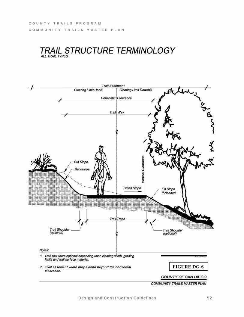
7.4 Trail Structure
This section discusses the components of trail development (see Figure DG-6).
Sustainability is the number one priority for new trail construction. A well constructed
Design and Construction Guidelines 90
C O U N T Y T R A I L S P R O G R A M
C O M M U N I T Y T R A I L S M A S T E R P L A N
sustainable trail requires less maintenance tasks and will need to be performed less frequently. Trails should follow natural land contours and along steep slopes full bench cut construction should be used. It will provide the best opportunity for a sustainable trail.
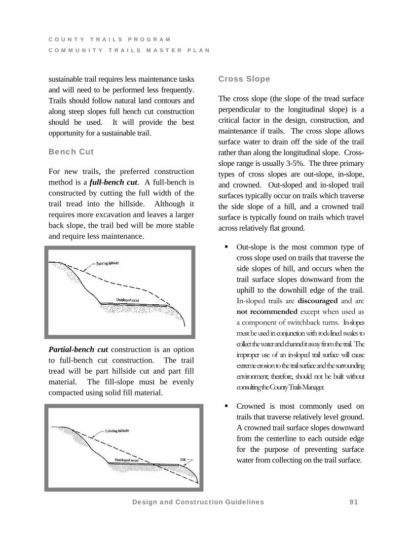
Bench Cut
For new trails, the preferred construction method is a full-bench cut. A full-bench is constructed by cutting the full width of the trail tread into the hillside. Although it requires more excavation and leaves a larger back slope, the trail bed will be more stable and require less maintenance.
Partial-bench cut construction is an option to full-bench cut construction. The trail tread will be part hillside cut and part fill material. The fill-slope must be evenly compacted using solid fill material.
Cross Slope
The cross slope (the slope of the tread surface perpendicular to the longitudinal slope) is a critical factor in the design, construction, and maintenance if trails. The cross slope allows surface water to drain off the side of the trail rather than along the longitudinal slope. Cross-slope range is usually 3-5%. The three primary types of cross slopes are out-slope, in-slope, and crowned. Out-sloped and in-sloped trail surfaces typically occur on trails which traverse the side slope of a hill, and a crowned trail surface is typically found on trails which travel across relatively flat ground.
Out-slope is the most common type of cross slope used on trails that traverse the side slopes of hill, and occurs when the trail surface slopes downward from the uphill to the downhill edge of the trail. In-sloped trails are discouraged and are not recommended except when used as a component of switchback turns. In-slopes must be used in conjunction with rock-lined swales to collect the water and channel it away from the trail. The improper use of an in-sloped trail surface will cause extreme erosion to the trail surface and the surrounding environment; therefore, should not be built without consulting the County Trails Manager.
Crowned is most commonly used on trails that traverse relatively level ground. A crowned trail surface slopes downward from the centerline to each outside edge for the purpose of preventing surface water from collecting on the trail surface.
Design and Construction Guidelines 91
C O U N T Y T R A I L S P R O G R A M
C O M M U N I T Y T R A I L S M A S T E R P L A N
Design and Construction Guidelines 92
Easement and Trail Tread Widths
It is necessary the easement for a trail setting provide sufficient width for management/ maintenance and/or buffer space from adjacent uses so as not to preclude the viability of those uses. Easement widths requested for trail development should correspond to those contained in the Trail Design Guideline Matrix (Table DG-1). Trail easement are intended to accommodate multiple users (hikers, equestrians and mountain bicyclists) and to provide sufficient width as necessary to avoid obstructions such as trees, large rocks, utilities and equipment cabinets.
The width of a trail or its “tread” is based on the amount or intensity of use, field conditions such as topography and by the amount of influence or impact to surrounding sensitive environmental resources. The trail tread width shall be clear and unobstructed by the natural environment (rocks, trees, etc.) or man-made obstructions (fences, walls, equipment, utility boxes, etc.). Where treads are narrow (5 feet or less) including types B and C, occasional passing areas or turnouts should be provided at places with gentle slopes or upon approval from the County Trail Manager. The County, based on site-specific conditions and features of the development layout, will determine appropriate locations and widths of
the trail easement. Trail easements less than 20
feet wide can prove problematic both for the County and the landowner. For example, if the easement is too narrow and heavy rains or minor land slippage causes a portion of a trail to wash out, it may be difficult to repair or replace the trail within the narrow easement. Similarly, narrow easements are more vulnerable to being blocked by the encroachment of structures, fences, or landscaping.
Where major regional trails or streamside trails are involved, the County will retain sufficient easement width to provide for higher levels of future use and/or provide greater flexibility in protecting riparian resources. Where trails correspond with utility easements, trail easement width will often be the same as the underlying utility easement for ease of legal processing. In rare instances the terrain may be so steep, the soils conditions so unstable or the biological or cultural (historical and archaeological) resources so unique that a wide easement may be requested.
Erosion Control Devices
Disturbance of the soil surface should be minimized in order to reduce erosion and associated maintenance problems. Trail designs should comply with
current County drainage and storm water
pollution standards.
FIGURE DG-6
Trail Easement
2. Trail easement width may extend beyond the horizontal clearence.
FIGURE DG-6
C O U N T Y T R A I L S P R O G R A M
C O M M U N I T Y T R A I L S M A S T E R P L A N
Easement and Trail Tread Widths
It is necessary the easement for a trail setting provide sufficient width for management/ maintenance and/or buffer space from adjacent uses so as not to preclude the viability of those uses. Easement widths requested for trail development should correspond to those contained in the Trail Design Guideline Matrix (Table DG-1). Trail easement are intended to accommodate multiple users (hikers, equestrians and mountain bicyclists) and to provide sufficient width as necessary to avoid obstructions such as trees, large rocks, utilities and equipment cabinets.
The width of a trail or its “tread” is based on the amount or intensity of use, field conditions such as topography and by the amount of influence or impact to surrounding sensitive environmental resources. The trail tread width shall be clear and unobstructed by the natural environment (rocks, trees, etc.) or man-made obstructions (fences, walls, equipment, utility boxes, etc.). Where treads are narrow (5 feet or less) including types B and C, occasional passing areas or turnouts should be provided at places with gentle slopes or upon approval from the County Trail Manager.
The County, based on site-specific conditions and features of the development layout, will determine appropriate locations and widths of the trail easement. Trail easements less than 20 feet wide can prove problematic both for the County and the landowner. For example, if the easement is too narrow and heavy rains or minor land slippage causes a portion of a trail
to wash out, it may be difficult to repair or replace the trail within the narrow easement. Similarly, narrow easements are more vulnerable to being blocked by the encroachment of structures, fences, or landscaping.
Where major regional trails or streamside trails are involved, the County will retain sufficient easement width to provide for higher levels of future use and/or provide greater flexibility in protecting riparian resources. Where trails correspond with utility easements, trail easement width will often be the same as the underlying utility easement for ease of legal processing. In rare instances the terrain may be so steep, the soils conditions so unstable or the biological or cultural (historical and archaeological) resources so unique that a wide easement may be requested.
Erosion Control Devices
Disturbance of the soil surface should be minimized in order to reduce erosion and associated maintenance problems. Trail designs should comply with current County drainage and storm water pollution standards.
Design and Construction Guidelines 93
C O U N T Y T R A I L S P R O G R A M
C O M M U N I T Y T R A I L S M A S T E R P L A N
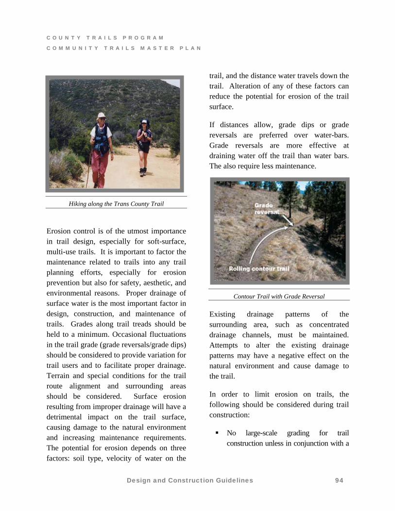
Hiking along the Trans County Trail
Erosion control is of the utmost importance in trail design, especially for soft-surface, multi-use trails. It is important to factor the maintenance related to trails into any trail planning efforts, especially for erosion prevention but also for safety, aesthetic, and environmental reasons. Proper drainage of surface water is the most important factor in design, construction, and maintenance of trails. Grades along trail treads should be held to a minimum. Occasional fluctuations in the trail grade (grade reversals/grade dips) should be considered to provide variation for trail users and to facilitate proper drainage. Terrain and special conditions for the trail route alignment and surrounding areas should be considered. Surface erosion resulting from improper drainage will have a detrimental impact on the trail surface, causing damage to the natural environment and increasing maintenance requirements. The potential for erosion depends on three factors: soil type, velocity of water on the
trail, and the distance water travels down the trail. Alteration of any of these factors can reduce the potential for erosion of the trail surface.
If distances allow, grade dips or grade reversals are preferred over water-bars. Grade reversals are more effective at draining water off the trail than water bars. The also require less maintenance.
Contour Trail with Grade Reversal
Existing drainage patterns of the surrounding area, such as concentrated drainage channels, must be maintained. Attempts to alter the existing drainage patterns may have a negative effect on the natural environment and cause damage to the trail.
In order to limit erosion on trails, the following should be considered during trail construction:
No large-scale grading for trail construction unless in conjunction with a
Design and Construction Guidelines 94
C O U N T Y T R A I L S P R O G R A M
C O M M U N I T Y T R A I L S M A S T E R P L A N
development project where large-scale grading has been found acceptable.
The degree of cut allowed on a slope depends on the soil type, hardness, and surrounding natural resources. Ultimate cuts will be contoured to
blend with the natural slopes. Only where necessary, earthen berms,
culverts or brow ditches will be utilized to divert runoff and to eliminate erosion of the trail.
Limited terracing or building steps to avoid large-scale grading will handle steep areas. Steps must be reinforced with stone or wood.
In order to reduce erosion and maintenance problems, disturbance of the soil surface will be kept to a minimum. Only those rocks, stumps, and roots, which interfere with safe passage, will be removed.
Trail designs will comply with the current County Drainage Manual. Surface water will be diverted from trails by out sloping the trail tread. Where necessary water bars may be used to divert water on running grades.
Where trails are located near water bodies listed as impaired pursuant to the Clean Water Act Section 303(d) list, surface water shall be diverted from trails by directing runoff away from the water body.
In determining which drainage facility to use, the order of priorities may not always be possible to follow, depending on terrain features, volume of water involve, and soil characteristics1. Each trail should be looked at individually in order to determine the best solution for drainage issues.
Water bars constructed of wood, rock or rubber members laid perpendicular (at 45 -60 degree angle) to the path of travel should not be calculated into new trail construction. During trail maintenance, they may be necessary to add to poorly designed trails where other solutions are not available or practical.
On moderate to steep side slopes a periodic reverse in the grade should be included to create dips for drainage purposes. When grade dips are included in initial construction, the need for water-bars may be eliminated.
Function
Trails and pathways are considered a public facility like a library, school, flood channel, picnic area, or parking lot with a primary function of providing both recreational opportunities as well as alternative transportation infrastructure. The function of a trail was influential in the development of the optimal guidelines and trail types. The future planning, design, and implementation of specialty trails will consider a trail function when developing its guideline.
1 Klamath District Maintenance Guide
Design and Construction Guidelines 95
C O U N T Y T R A I L S P R O G R A M
C O M M U N I T Y T R A I L S M A S T E R P L A N
Grade
The degree to which a trail rises or falls over a linear distance is an important factor in determining the length of a trail section, level of difficulty, appropriate user types, and drainage and maintenance requirements. In general, no large-scale grading should be used for trail construction. Varying trail grades are acceptable, but excessive trail grades should be minimized, as topography permits. The optimum grade ranges described in the Trail Design Guideline Matrix (Table DG-1) are advisory. Grades 15 percent or less are preferred but may not be feasible in some locations. Where grades exceed 10 percent for an extended length, long gradual switchbacks may be used, provided there is sufficient easement width. The County may consider varying the guidelines for grade limits with the trail settings. For example, some rural or primitive trails might be steeper and narrower than accepted standard guidelines in order to provide a different experience for users.
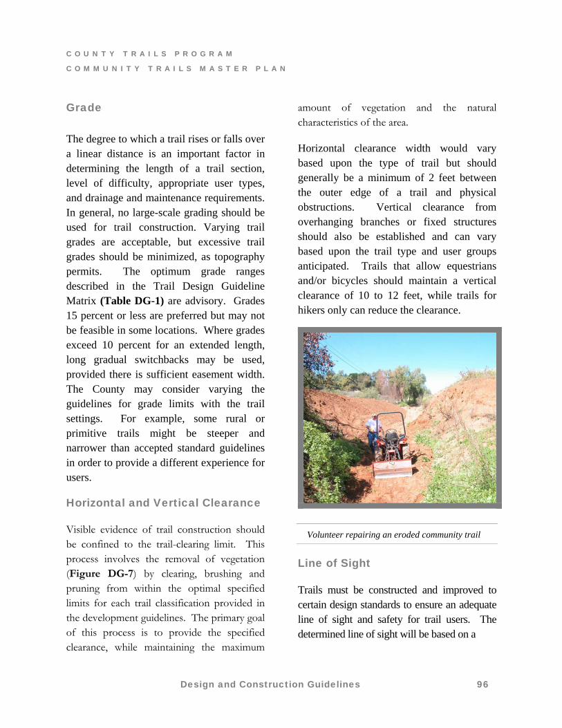
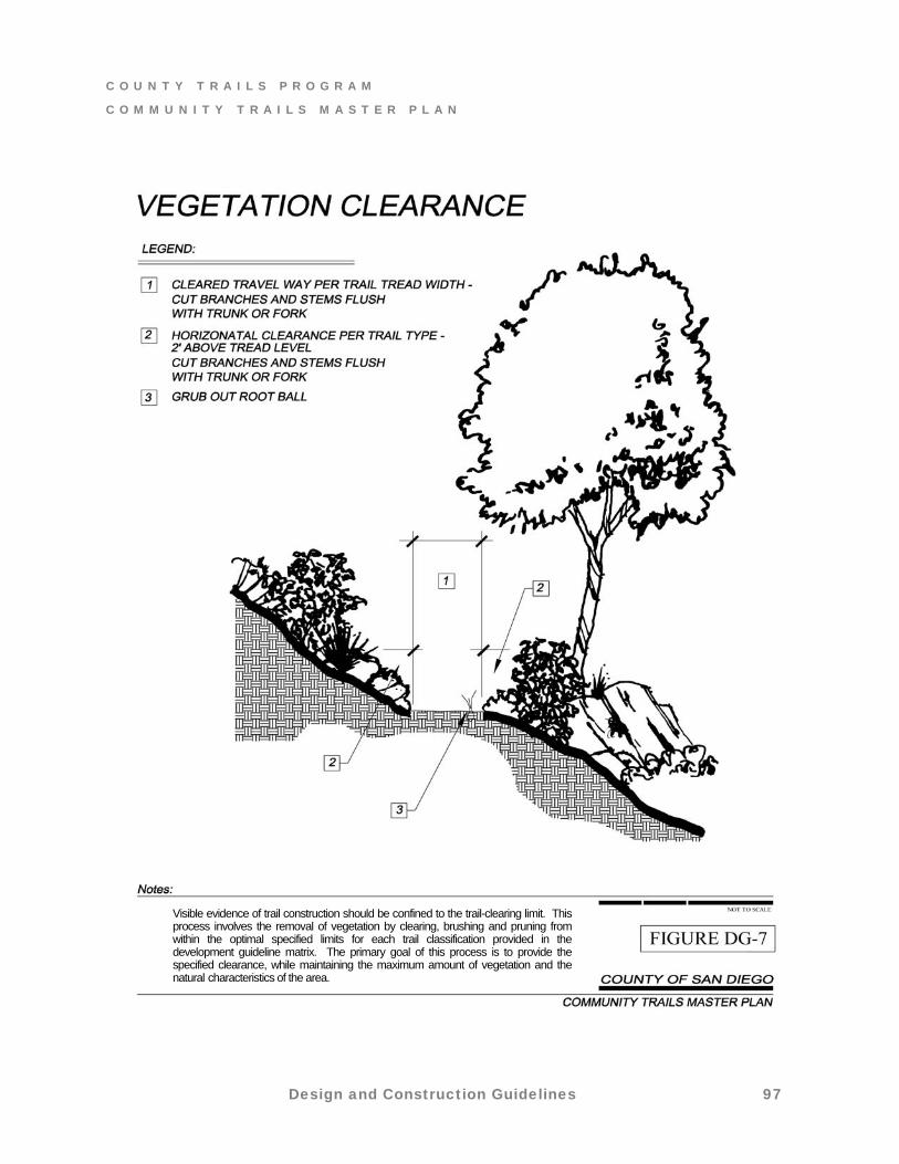
Horizontal and Vertical Clearance
Visible evidence of trail construction should be confined to the trail-clearing limit. This process involves the removal of vegetation (Figure DG-7) by clearing, brushing and pruning from within the optimal specified limits for each trail classification provided in the development guidelines. The primary goal of this process is to provide the specified clearance, while maintaining the maximum
amount of vegetation and the natural characteristics of the area.
Horizontal clearance width would vary based upon the type of trail but should generally be a minimum of 2 feet between the outer edge of a trail and physical obstructions. Vertical clearance from overhanging branches or fixed structures should also be established and can vary based upon the trail type and user groups anticipated. Trails that allow equestrians and/or bicycles should maintain a vertical clearance of 10 to 12 feet, while trails for hikers only can reduce the clearance.
Volunteer repairing an eroded community trail
Line of Sight
Trails must be constructed and improved to certain design standards to ensure an adequate line of sight and safety for trail users. The determined line of sight will be based on a
Design and Construction Guidelines 96
C O U N T Y T R A I L S P R O G R A M
C O M M U N I T Y T R A I L S M A S T E R P L A N
Design and Construction Guidelines 97
Visible evidence of trail construction should be confined to the trail-clearing limit. This process involves the removal of vegetation by clearing, brushing and pruning from within the optimal specified limits for each trail classification provided in the development guideline matrix. The primary goal of this process is to provide the specified clearance, while maintaining the maximum amount of vegetation and the natural characteristics of the area.
C O U N T Y T R A I L S P R O G R A M
C O M M U N I T Y T R A I L S M A S T E R P L A N
case-by-case basis. However, for safety purposes, the recommended clear width of multi-use trails that includes mountain biking should be developed to allow a 100-foot average site distance. The criteria evaluated includes the speed of the user groups and their reaction time to maintain control. Vegetation clearance is another key factor affecting line of sight. If sight distances on curves, around hills or through densely vegetated areas are less than 100 feet, safety signs and reduced speed limits should be required.
Where trails intersect or cross roads, the Department of Public Works will ensure that improvement requirements include the following safety standards:
Trails should intersect roads at approximately ninety (90) degree angles.
Where trails cross roads, they should do so at ninety (90) degree angles and crossing/warning signage posted in both vehicular directions. If deemed necessary, the paved roadway surfaces shall be marked with a painted crosswalk and/or flashing warning lights.
Surface Material
Trail surface shall be appropriate for the intended use and shall help to minimize runoff and erosion problems. Ideally, surfaces should allow for a variety of recreational uses and should be easily maintained. Wherever feasible, trails should be of materials that provide a firm, smooth surface meeting requirements and guidelines for
accessible trails. The County generally accepts compacted decomposed granite (DG) as a typical trail surface material. Native soil may also be appropriate in some cases if it can be demonstrated to have acceptable standards to provide a firm, smooth surface.
Parking surfaces and trail materials that reduce dust will be used. Dust suppression techniques, including watering of disturbed lands, should be used in constructing regional staging areas and multi-use trails to reduce dust during trail construction. Binding agents may be added to soil to reduce dust at high traffic staging areas or trails.
7.5 Trail Support Features
Basic trail amenities listed are to provide guidance concerning appropriate support facilities for the CTMP. Support facilities for trails vary with the intended use of the trail, trail type and trail length. Trail structures such as switchbacks, climbing turns, retaining walls, grade reversals and similar trail elements are common in trail construction. Some are difficult to design or construct correctly. If proper maintenance is not performed regularly, their life-spans may be shortened and they may cause damage to the trail or facility. A good trail alignment and a correctly constructed trail with properly built trail support features can last for decades. They represent optimum conditions desired by the County for the CTMP. Individual CPSGs may require specialized “packages” for their communities. Refer to the individual community sections for more detail.
Design and Construction Guidelines 98
C O U N T Y T R A I L S P R O G R A M
C O M M U N I T Y T R A I L S M A S T E R P L A N
Standards for drainage crossings, trail bridges, and hardware for construction should be addressed.
Whenever possible, use a natural water crossing. Reinforce stream banks by armoring with stone or using “geoweb” mesh.
Trails crossing creeks and drainages may require a bridge or culvert and these structures should be carefully designed for user safety, to minimize disturbance and with the least number of crossings as feasible.
Approaches to bridges will vary but typically should be 50 to 100 feet in length, level and straight. Bridge widths should correspond to established tread width for the various trail types. Bridges should also be carefully designed to meet the needs and weight of horse travel and maintenance vehicles and include railings when necessary. High and narrow bridges are discouraged and may frighten young or inexperienced horses. If wood members are used for bridge crossings, the planks should be oriented at 45 to 90 degree angles to the direction of travel. Gaps between planking oriented in the direction of travel may be a tripping hazard to hikers and equestrians and trap bicycle tires.
Anchor Points
Large or unusual tree, rocks or patch of shrubs that add interest and draw attention to landscape features.
Barriers
Barriers such as vegetation or fencing may provide obstruction between trail surface and grade separations, including fencing on bridges, and stream or gully crossings. Bollards, boulders, logs, stiles, trail gates and/or other structures will be used to prevent motorized vehicles from entering trail routes at any crossing of a public road right-of-way, or at any trail staging area.
Benches
Benches for resting should be provided at regular intervals within 1/2 mile of regional staging areas along trail routes. These should be located at places with aesthetic qualities, viewpoints, and particularly at the end of any long uphill stretches.
Bridges
Bridges or other structures may be provided to aid in crossing rivers, streams, creeks or vehicular roadways. The width of a trail bridge should be taken from the interior dimension; that is, inside rail to rail. Since trails are intended to be multi-use and all bridges must be designed for equestrian safety. A minimum of 8 feet wide for single or limited-use trail bridge spanning very short distances with good line of sight; 12 - 15 feet wide for natural-surface, multi-use trails and minimum 10-12 feet wide when contiguous with a vehicular roadway. Other than a single use bridge, all bridges shall be constructed to accommodate maintenance or emergency vehicles. Additional width and/or height may be required for equestrian use or on extended bridge lengths. Bridge surfaces should be solid, non-slip and all-weather surface.
Design and Construction Guidelines 99
C O U N T Y T R A I L S P R O G R A M
C O M M U N I T Y T R A I L S M A S T E R P L A N
Natural surface or decomposed granite is preferable. Heavy wood planks are acceptable. Stringers should be strong enough so the deck doesn’t “bounce” when horses cross. Concrete and asphalt surfaces are not recommended as they may become slippery for horses. If concrete is used, it must be a heavy broom finish. All bridges on multi-use trails must have minimum 60-inch-high railings. Depending upon the location and length of the bridge, higher railing may be required.
The approach to a bridge should encourage users to naturally aim for the center of the bridge. Wing walls or approach walls should be incorporated into the bridge design especially if there are steep banks on the sides. Unprotected approaches may cause users to try to get down to the water and try to avoid the bridge entirely. An unwilling horse may begin to shy sideways, endangering himself and the rider if there are no secure approaches.
Arched bridges are aesthetically appealing, but horses are almost guaranteed to slip on the decking. A horse could slip and fall on such a bridge. For safety, the camber on equestrian bridges should not exceed 5 percent.2
Bridge with 5% camber and “rub rails”2
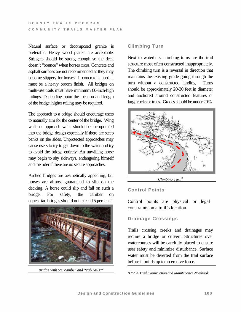
Climbing Turn
Next to waterbars, climbing turns are the trail structure most often constructed inappropriately. The climbing turn is a reversal in direction that maintains the existing grade going through the turn without a constructed landing. Turns should be approximately 20-30 feet in diameter and anchored around constructed features or large rocks or trees. Grades should be under 20%.
Climbing Turn3
Control Points
Control points are physical or legal constraints on a trail’s location.
Drainage Crossings
Trails crossing creeks and drainages may require a bridge or culvert. Structures over watercourses will be carefully placed to ensure user safety and minimize disturbance. Surface water must be diverted from the trail surface before it builds up to an erosive force.
2USDA Trail Construction and Maintenance Notebook
Design and Construction Guidelines 100
C O U N T Y T R A I L S P R O G R A M
C O M M U N I T Y T R A I L S M A S T E R P L A N
Design and Construction Guidelines 101
However, placement of culverts or drainage facilities within trail easements should be avoided and only placed underground. These devices are not allowed to discharge drainage on to the trail easement. Erosion control measures will be taken to prevent erosion at the outfalls of drainage structures.
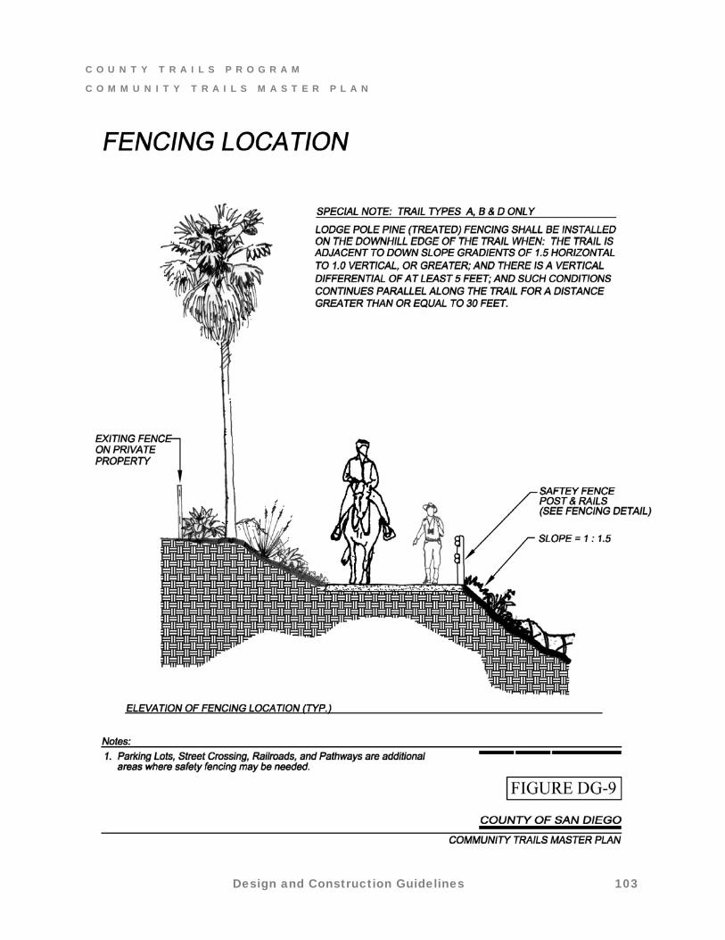
Fences are not allowed to be installed within the trail easement. Fencing both sides of an established trail tread or easement will not be permitted unless the interior inside dimension (rail to rail) exceeds 10 feet. Exceptions should be discussed and approved by the Trails Program Manager. Each community may have different references about the extent and location of fencing. Emergency Telephones
Along trails located outside of public parks and along trails that pass through more remote areas or private lands, consider installing solar-powered emergency telephones at regular intervals. Where practical, placement of emergency telephones should coincide with staging areas, emergency access points and helicopter landing sites.
Furniture
Trail furniture such as tables, chairs, benches, hitching rails, etc. maybe used for convenience or decoration on trails
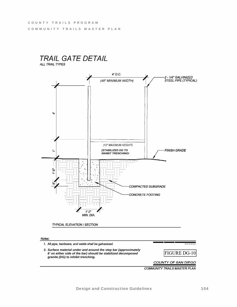
Gates
Installation of gates should be avoided unless issues of security or containment of livestock become an issue (Figure DG-10). Not only do gates create a management problem and a potential safety hazard, they also degrade the quality of recreational experiences by turning the focus away from enjoyment of natural surroundings. In addition, their associated costs of installation and maintenance, reduce their benefits.
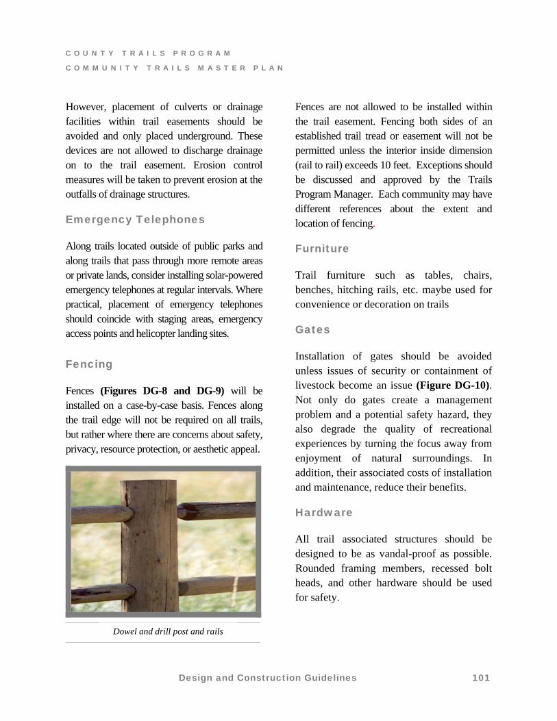
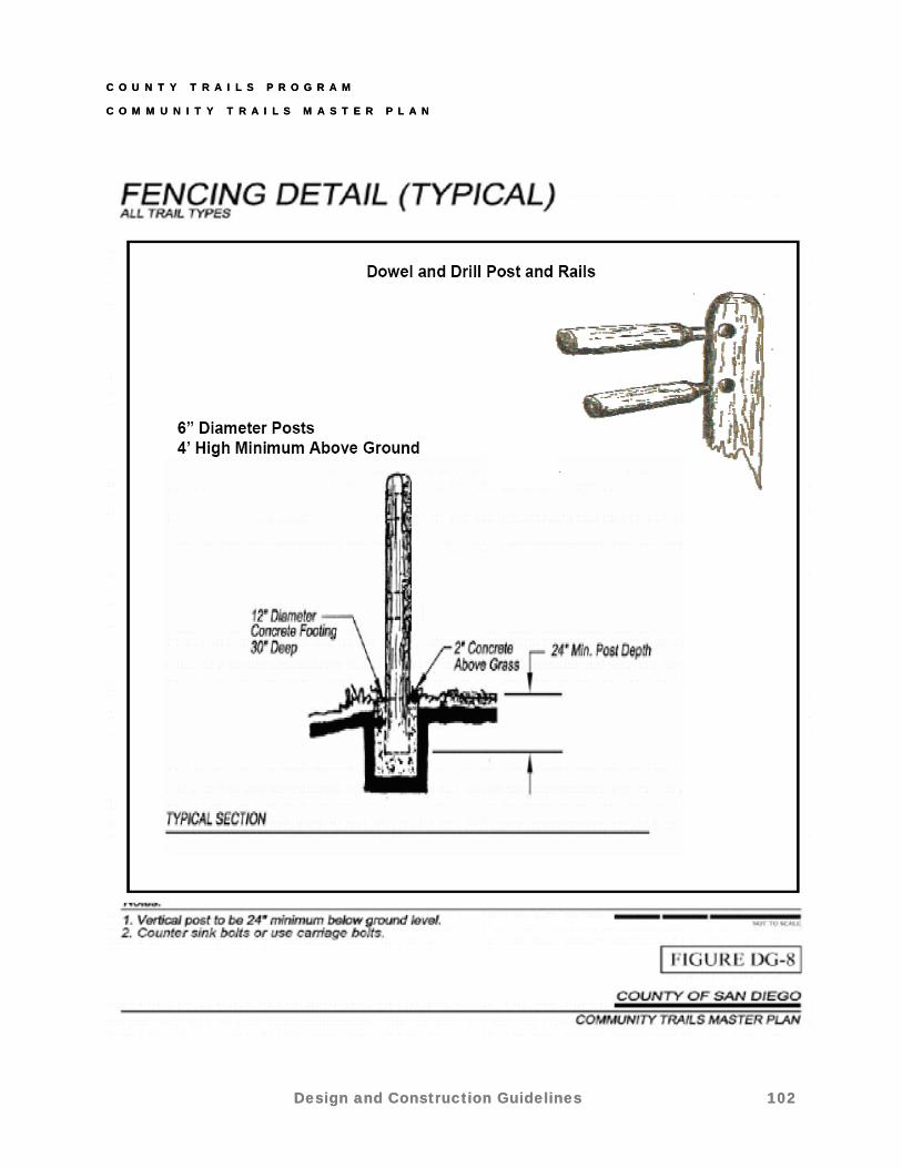
Fencing
Fences (Figures DG-8 and DG-9) will be installed on a case-by-case basis. Fences along the trail edge will not be required on all trails, but rather where there are concerns about safety, privacy, resource protection, or aesthetic appeal.
Hardware
All trail associated structures should be designed to be as vandal-proof as possible. Rounded framing members, recessed bolt heads, and other hardware should be used for safety.
Dowel and drill post and rails
C O U N T Y T R A I L S P R O G R A M
C O M M U N I T Y T R A I L S M A S T E R P L A N
C O U N T Y T R A I L S P R O G R A M
C O M M U N I T Y T R A I L S M A S T E R P L A N
Design and Construction Guidelines
Design and Construction Guidelines 102 102
C O U N T Y T R A I L S P R O G R A M
C O M M U N I T Y T R A I L S M A S T E R P L A N
Design and Construction Guidelines 103
C O U N T Y T R A I L S P R O G R A M
C O M M U N I T Y T R A I L S M A S T E R P L A N
Design and Construction Guidelines 104
(STABILIZED DG TO INHIBIT TRENCHING)
2. Surface material under and around the step bar (approximately 6’ on either side of the bar) should be stabilized decomposed granite (DG) to inhibit trenching.
C O U N T Y T R A I L S P R O G R A M
C O M M U N I T Y T R A I L S M A S T E R P L A N
Non-Potable Water
Water for domestic animals permitted on the trail should be provided at regional staging areas and, where possible, at an optimum of 5-mile intervals along regional and community trails.
Potable Water
Potable water for trail users should be provided at regional staging areas and, ideally, at least every 5 miles along regional trails. Where no potable water is available for an interval greater than 5 miles, safety signs indicating such conditions should be posted.
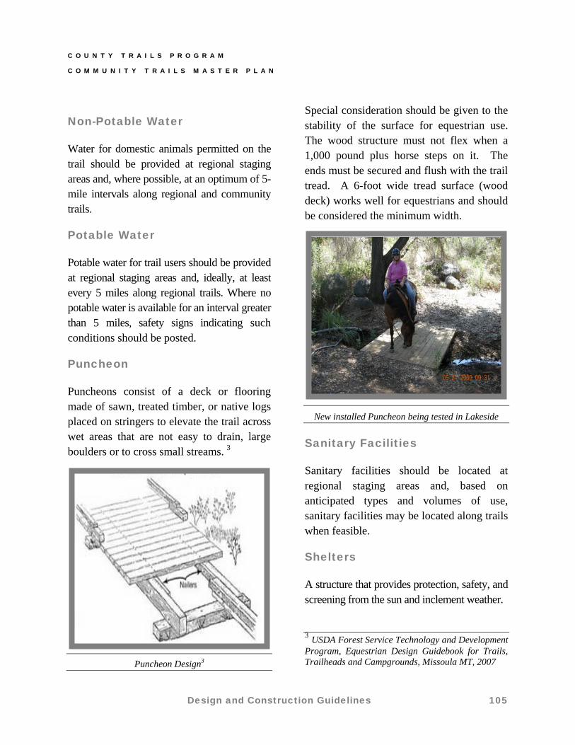
Puncheon
Puncheons consist of a deck or flooring made of sawn, treated timber, or native logs placed on stringers to elevate the trail across wet areas that are not easy to drain, large boulders or to cross small streams. 3
Puncheon Design3
Special consideration should be given to the stability of the surface for equestrian use. The wood structure must not flex when a 1,000 pound plus horse steps on it. The ends must be secured and flush with the trail tread. A 6-foot wide tread surface (wood deck) works well for equestrians and should be considered the minimum width.
New installed Puncheon being tested in Lakeside
Sanitary Facilities
Sanitary facilities should be located at regional staging areas and, based on anticipated types and volumes of use, sanitary facilities may be located along trails when feasible.
Shelters
A structure that provides protection, safety, and screening from the sun and inclement weather.
3 USDA Forest Service Technology and Development Program, Equestrian Design Guidebook for Trails, Trailheads and Campgrounds, Missoula MT, 2007
Design and Construction Guidelines 105
C O U N T Y T R A I L S P R O G R A M
C O M M U N I T Y T R A I L S M A S T E R P L A N
Signage
Signage may provide the following information and services:
Name, length, points of intersection and interest, and hours of operation
Use restrictions, rules, and ADA accessibility
Dangerous conditions such as aggressive wildlife, dry fire season, and vertical clearances
Facility locations including water, rest-rooms, and location of emergency phones
No trespassing notification to protect private property
Identify and educate about sensitive habitat, or historical points of interest
Direct regional traffic to staging areas away from neighborhoods that may have trail access points but do not have sufficient parking to accommodate such use
Interpretation and resource protection by indicating natural or historical points of interest or sensitive areas
Direct regional trail users to suitable staging areas and trailheads
Countywide Implementation Strategy 1.2: All trails should be marked. Markers or signs should be provided which encourage responsible trail use by providing users with directional information and information regarding property rights in order to
minimize public/private use conflicts and trespassing. Historically significant trail routes should have signs
that include appropriate historical information.
Steps
Steps can be a means to ascend a grade when no other trail construction methods such as switchbacks or climbing turns are feasible. Steps are built on-site from native or imported rock or a combination of rocks, wood and soil. New trail alignments and construction should avoid the need for steps.
Stream Access Points
In the detail design of any trail alignment parallel to a water-body, access points should be identified for environmental education and interpretive programs. Such access points should be located in coordination with the California Department of Fish and Game, the U.S. Army Corps of Engineers, and other jurisdictional agencies as appropriate.
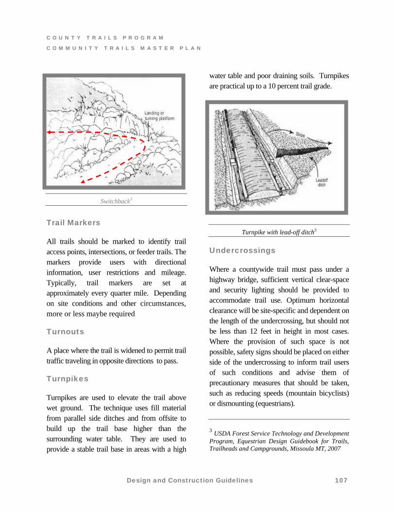
Switchbacks
Switchbacks are a reversal in the direction of a trail on hillsides with the intent to gain elevation in a limited distance. They are used as a method of achieving elevation change in steep terrain (usually steeper than 20 percent) and providing a reduced running slope. Switchbacks have a relatively level constructed landing at the point of direction change, anchored around constructed features or large rocks or trees, usually involving special treatment of the approaches, barriers, and drainage. Both the climbing turn and switchback take skill to locate and are relatively expensive to construct and maintain. Choosing when to use each one is not always easy.
Design and Construction Guidelines 106
C O U N T Y T R A I L S P R O G R A M
C O M M U N I T Y T R A I L S M A S T E R P L A N
Design and Construction Guidelines 107
Switchback3
Trail Markers
All trails should be marked to identify trail access points, intersections, or feeder trails. The markers provide users with directional information, user restrictions and mileage. Typically, trail markers are set at approximately every quarter mile. Depending on site conditions and other circumstances, more or less maybe required
Turnouts
A place where the trail is widened to permit trail traffic traveling in opposite directions to pass.
Turnpikes
Turnpikes are used to elevate the trail above wet ground. The technique uses fill material from parallel side ditches and from offsite to build up the trail base higher than the surrounding water table. They are used to provide a stable trail base in areas with a high
water table and poor draining soils. Turnpikes are practical up to a 10 percent trail grade.
Turnpike with lead-off ditch3
Undercrossings
Where a countywide trail must pass under a highway bridge, sufficient vertical clear-space and security lighting should be provided to accommodate trail use. Optimum horizontal clearance will be site-specific and dependent on the length of the undercrossing, but should not be less than 12 feet in height in most cases. Where the provision of such space is not possible, safety signs should be placed on either side of the undercrossing to inform trail users of such conditions and advise them of precautionary measures that should be taken, such as reducing speeds (mountain bicyclists) or dismounting (equestrians).
3 USDA Forest Service Technology and Development Program, Equestrian Design Guidebook for Trails, Trailheads and Campgrounds, Missoula MT, 2007