Embed Size (px)
Citation preview
FORM 1 Riparian Areas Regulation - Qualified Environmental Professional - Assessment Report
Form 1 EXAMPLE FOR ILLUSTRATIVE PURPOSES Page 1 of 24
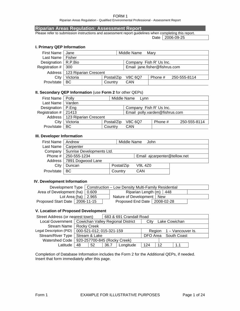
Riparian Areas Regulation: Assessment Report Please refer to submission instructions and assessment report guidelines when completing this report.
Date 2006-09-25
I. Primary QEP Information First Name Jane Middle Name Mary Last Name Fisher
Designation R.P.Bio Company Fish R’ Us Inc. Registration # 300 Email [email protected]
Address 123 Riparian Crescent City Victoria Postal/Zip V8C 6Q7 Phone # 250-555-8114
Prov/state BC Country CAN
II. Secondary QEP Information (use Form 2 for other QEPs) First Name Polly Middle Name Lynn Last Name Varden
Designation P.Eng Company Fish R’ Us Inc. Registration # 21413 Email [email protected]
Address 123 Riparian Crescent City Victoria Postal/Zip V8C 6Q7 Phone # 250-555-8114
Prov/state BC Country CAN
III. Developer Information First Name Andrew Middle Name John Last Name Carpenter
Company Sunrise Developments Ltd. Phone # 250-555-1234 Email [email protected] Address 7891 Dogwood Lane
City Duncan Postal/Zip V9L 4Z0 Prov/state BC Country CAN
IV. Development Information Development Type Construction – Low Density Multi-Family Residential
Area of Development (ha) 0.609 Riparian Length (m) 448 Lot Area (ha) 2.965 Nature of Development New
Proposed Start Date 2006-11-15 Proposed End Date 2008-02-28
V. Location of Proposed Development Street Address (or nearest town) 683 & 691 Crandall Road
Local Government Cowichan Valley Regional District City Lake Cowichan Stream Name Rocky Creek
Legal Description (PID) 000-521-012; 015-321-159 Region 1 – Vancouver Is. Stream/River Type Stream & Lake DFO Area South Coast
Watershed Code 920-257700-845 (Rocky Creek) Latitude 48 52 36.7 Longitude 124 12 1.1
Completion of Database Information includes the Form 2 for the Additional QEPs, if needed. Insert that form immediately after this page.
FORM 1 Riparian Areas Regulation - Qualified Environmental Professional - Assessment Report
Form 1 EXAMPLE FOR ILLUSTRATIVE PURPOSES Page 2 of 24
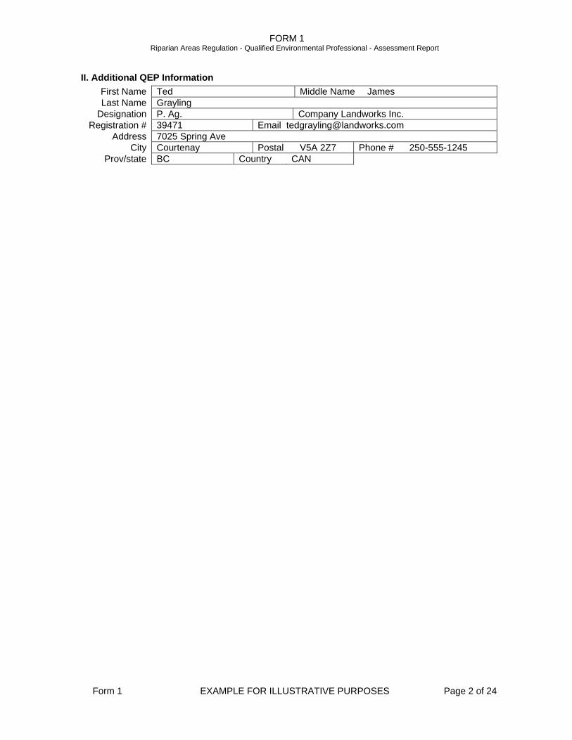
II. Additional QEP Information First Name Ted Middle Name James Last Name Grayling
Designation P. Ag. Company Landworks Inc. Registration # 39471 Email [email protected]
Address 7025 Spring Ave City Courtenay Postal V5A 2Z7 Phone # 250-555-1245
Prov/state BC Country CAN
FORM 1 Riparian Areas Regulation - Qualified Environmental Professional - Assessment Report
Form 1 EXAMPLE FOR ILLUSTRATIVE PURPOSES Page 3 of 24
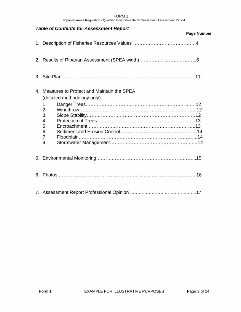
Table of Contents for Assessment Report Page Number
1. Description of Fisheries Resources Values ………………………………….4
2. Results of Riparian Assessment (SPEA width) ……………………………...6
3. Site Plan …………………………………………………………………………11
4. Measures to Protect and Maintain the SPEA (detailed methodology only). 1. Danger Trees…………………………………………………………….12 2. Windthrow………………………………………………………………...12 3. Slope Stability……………………………………………………………12 4. Protection of Trees……………………………………………………...13 5. Encroachment …………………………………………………………..13 6. Sediment and Erosion Control………………………………………….14 7. Floodplain………………………………………………………………....14 8. Stormwater Management……………………………………………..…14
5. Environmental Monitoring ……………………………………………………...15
6. Photos …………………………………………………………………………... 16 7. Assessment Report Professional Opinion ……………………………………….17
FORM 1 Riparian Areas Regulation - Qualified Environmental Professional - Assessment Report
Form 1 EXAMPLE FOR ILLUSTRATIVE PURPOSES Page 4 of 24
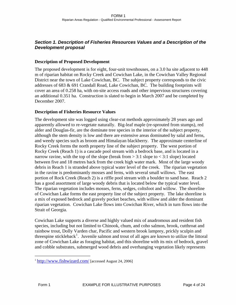
Section 1. Description of Fisheries Resources Values and a Description of the Development proposal
Description of Proposed Development
The proposed development is for eight, four-unit townhouses, on a 3.0 ha site adjacent to 448 m of riparian habitat on Rocky Creek and Cowichan Lake, in the Cowichan Valley Regional District near the town of Lake Cowichan, BC. The subject property corresponds to the civic addresses of 683 & 691 Crandall Road, Lake Cowichan, BC. The building footprints will cover an area of 0.258 ha, with on-site access roads and other impervious structures covering an additional 0.351 ha. Construction is slated to begin in March 2007 and be completed by December 2007. Description of Fisheries Resource Values
The development site was logged using clear-cut methods approximately 28 years ago and apparently allowed to re-vegetate naturally. Big-leaf maple (re-sprouted from stumps), red alder and Douglas-fir, are the dominate tree species in the interior of the subject property, although the stem density is low and there are extensive areas dominated by salal and ferns, and weedy species such as broom and Himalayan blackberry. The approximate centerline of Rocky Creek forms the north property line of the subject property. The west portion of Rocky Creek (Reach 1) is a cascade pool stream with a bedrock base, and is located in a narrow ravine, with the top of the slope (break from > 3:1 slope to < 3:1 slope) located between five and 18 metres back from the creek high water mark. Most of the large woody debris in Reach 1 is stranded above typical water level of the creek. The riparian vegetation in the ravine is predominantly mosses and ferns, with several small willows. The east portion of Rock Creek (Reach 2) is a riffle pool stream with a boulder to sand base. Reach 2 has a good assortment of large woody debris that is located below the typical water level. The riparian vegetation includes mosses, ferns, sedges, coltsfoot and willow. The shoreline of Cowichan Lake forms the east property line of the subject property. The lake shoreline is a mix of exposed bedrock and gravely pocket beaches, with willow and alder the dominant riparian vegetation. Cowichan Lake flows into Cowichan River, which in turn flows into the Strait of Georgia. Cowichan Lake supports a diverse and highly valued mix of anadromous and resident fish species, including but not limited to Chinook, chum, and coho salmon, brook, cutthroat and rainbow trout, Dolly Varden char, Pacific and western brook lamprey, prickly sculpin and threespine stickleback1. Juvenile salmon and trout of all ages are known to utilize the littoral zone of Cowichan Lake as foraging habitat, and this shoreline with its mix of bedrock, gravel and cobble substrates, submerged wood debris and overhanging vegetation likely represents
1 http://www.fishwizard.com/ [accessed August 24, 2006]
FORM 1 Riparian Areas Regulation - Qualified Environmental Professional - Assessment Report
Form 1 EXAMPLE FOR ILLUSTRATIVE PURPOSES Page 5 of 24
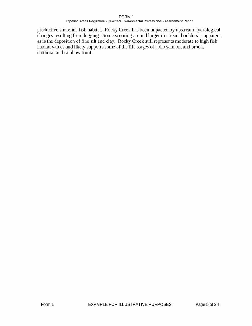
productive shoreline fish habitat. Rocky Creek has been impacted by upstream hydrological changes resulting from logging. Some scouring around larger in-stream boulders is apparent, as is the deposition of fine silt and clay. Rocky Creek still represents moderate to high fish habitat values and likely supports some of the life stages of coho salmon, and brook, cutthroat and rainbow trout.
FORM 1 Riparian Areas Regulation - Qualified Environmental Professional - Assessment Report
Form 1 EXAMPLE FOR ILLUSTRATIVE PURPOSES Page 6 of 24
Section 2. Results of Riparian Assessment (SPEA width) Attach or insert the Form 3 or Form 4 assessment form(s). Use enough duplicates of the form to produce a complete riparian area assessment for the proposed development
2. Results of Detailed Riparian Assessment Refer to Chapter 3 of Assessment Methodology Date: 2006-08-11 Description of Water bodies involved (number, type) 3, stream & lake Stream x Wetland Lake Ditch
Number of reaches 2 Reach # 1
Channel width and slope and Channel Type (use only if water body is a stream or a ditch, and only provide widths if a ditch)
Channel Width(m) Gradient (%) starting point 3.6
upstream 4.7 4.6 5.3 4.8 7.2 6.0
downstream 6.9 3.0 3.3 3.2 3.1 3.6
Total: minus high /low 41.4 mean 4.6 3.8
R/P C/P S/P Channel Type x
I, Jane Fisher, hereby certify that: a) I am a qualified environmental professional, as defined in the
Riparian Areas Regulation made under the Fish Protection Act; b) I am qualified to carry out this part of the assessment of the
development proposal made by the developer Sunrise Developments Ltd.;
c) I have carried out an assessment of the development proposal and my assessment is set out in this Assessment Report; and
d) In carrying out my assessment of the development proposal, I have followed the assessment methods set out in the Schedule to the Riparian Areas Regulation.
Site Potential Vegetation Type (SPVT) Yes No SPVT Polygons x Tick yes only if multiple polygons, if No then fill in one set of SPVT data boxes I, Jane Fisher, hereby certify that:
a) I am a qualified environmental professional, as defined in the Riparian Areas Regulation made under the Fish Protection Act;
b) I am qualified to carry out this part of the assessment of the development proposal made by the developer Sunrise Developments Ltd ;
c) I have carried out an assessment of the development proposal and my assessment is set out in this Assessment Report; and
d) In carrying out my assessment of the development proposal, I have followed the assessment methods set out in the Schedule to the Riparian Areas Regulation.
Polygon No: n/a Method employed if other than TR LC SH TR SPVT Type x
n/a
FORM 1 Riparian Areas Regulation - Qualified Environmental Professional - Assessment Report
Form 1 EXAMPLE FOR ILLUSTRATIVE PURPOSES Page 7 of 24
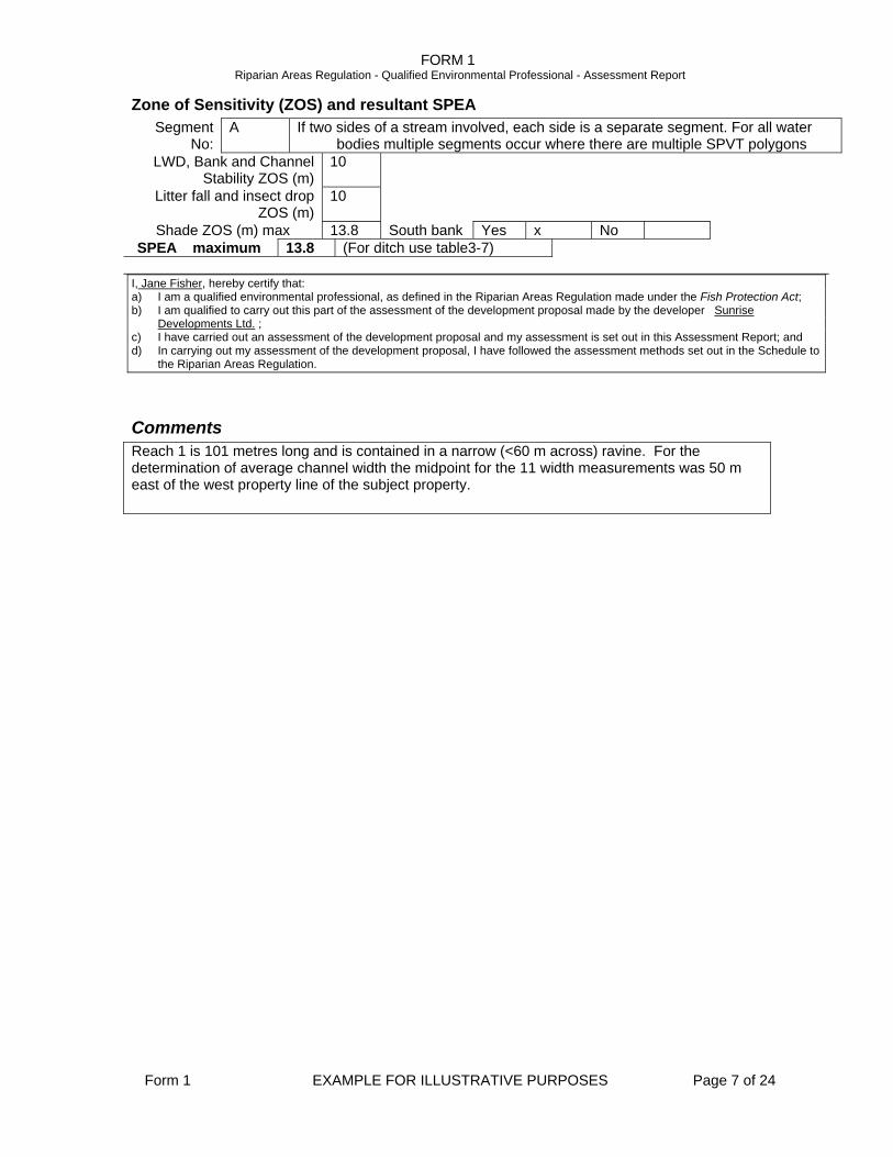
Zone of Sensitivity (ZOS) and resultant SPEA Segment
No: A If two sides of a stream involved, each side is a separate segment. For all water
bodies multiple segments occur where there are multiple SPVT polygons LWD, Bank and Channel
Stability ZOS (m) 10
Litter fall and insect drop ZOS (m)
10
Shade ZOS (m) max 13.8 South bank Yes x No SPEA maximum 13.8 (For ditch use table3-7)
I, Jane Fisher, hereby certify that: a) I am a qualified environmental professional, as defined in the Riparian Areas Regulation made under the Fish Protection Act; b) I am qualified to carry out this part of the assessment of the development proposal made by the developer Sunrise
Developments Ltd. ; c) I have carried out an assessment of the development proposal and my assessment is set out in this Assessment Report; and d) In carrying out my assessment of the development proposal, I have followed the assessment methods set out in the Schedule to
the Riparian Areas Regulation.
Comments Reach 1 is 101 metres long and is contained in a narrow (<60 m across) ravine. For the determination of average channel width the midpoint for the 11 width measurements was 50 m east of the west property line of the subject property.
FORM 1 Riparian Areas Regulation - Qualified Environmental Professional - Assessment Report
Form 1 EXAMPLE FOR ILLUSTRATIVE PURPOSES Page 8 of 24
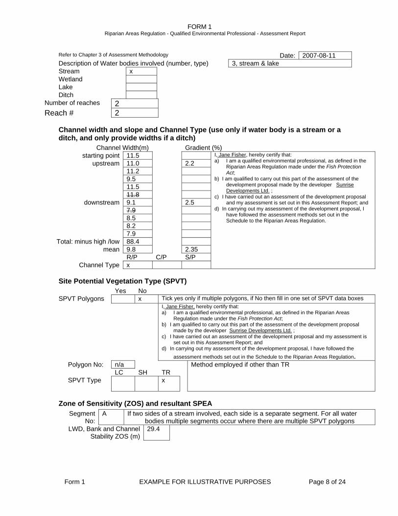
Refer to Chapter 3 of Assessment Methodology Date: 2007-08-11 Description of Water bodies involved (number, type) 3, stream & lake Stream x Wetland Lake Ditch
Number of reaches 2 Reach # 2
Channel width and slope and Channel Type (use only if water body is a stream or a ditch, and only provide widths if a ditch)
Channel Width(m) Gradient (%) starting point 11.5
upstream 11.0 2.2 11.2 9.5 11.5 11.8
downstream 9.1 2.5 7.9 8.5 8.2 7.9
Total: minus high /low 88.4 mean 9.8 2.35
R/P C/P S/P Channel Type x
I, Jane Fisher, hereby certify that: a) I am a qualified environmental professional, as defined in the
Riparian Areas Regulation made under the Fish Protection Act;
b) I am qualified to carry out this part of the assessment of the development proposal made by the developer Sunrise Developments Ltd. ;
c) I have carried out an assessment of the development proposal and my assessment is set out in this Assessment Report; and
d) In carrying out my assessment of the development proposal, I have followed the assessment methods set out in the Schedule to the Riparian Areas Regulation.
Site Potential Vegetation Type (SPVT) Yes No SPVT Polygons x Tick yes only if multiple polygons, if No then fill in one set of SPVT data boxes I, Jane Fisher, hereby certify that:
a) I am a qualified environmental professional, as defined in the Riparian Areas Regulation made under the Fish Protection Act;
b) I am qualified to carry out this part of the assessment of the development proposal made by the developer Sunrise Developments Ltd. ;
c) I have carried out an assessment of the development proposal and my assessment is set out in this Assessment Report; and
d) In carrying out my assessment of the development proposal, I have followed the assessment methods set out in the Schedule to the Riparian Areas Regulation.
Polygon No: n/a Method employed if other than TR LC SH TR SPVT Type x
Zone of Sensitivity (ZOS) and resultant SPEA Segment
No: A If two sides of a stream involved, each side is a separate segment. For all water
bodies multiple segments occur where there are multiple SPVT polygons LWD, Bank and Channel
Stability ZOS (m) 29.4
FORM 1 Riparian Areas Regulation - Qualified Environmental Professional - Assessment Report
Form 1 EXAMPLE FOR ILLUSTRATIVE PURPOSES Page 9 of 24
Litter fall and insect drop ZOS (m)
15
Shade ZOS (m) max 29.4 South bank Yes x No I, Jane Fisher, hereby certify that: a) I am a qualified environmental professional, as defined in the Riparian Areas Regulation made under the Fish Protection Act; b) I am qualified to carry out this part of the assessment of the development proposal made by the developer Sunrise
Developments Ltd. ; c) I have carried out an assessment of the development proposal and my assessment is set out in this Assessment Report; and d) In carrying out my assessment of the development proposal, I have followed the assessment methods set out in the Schedule to
the Riparian Areas Regulation.
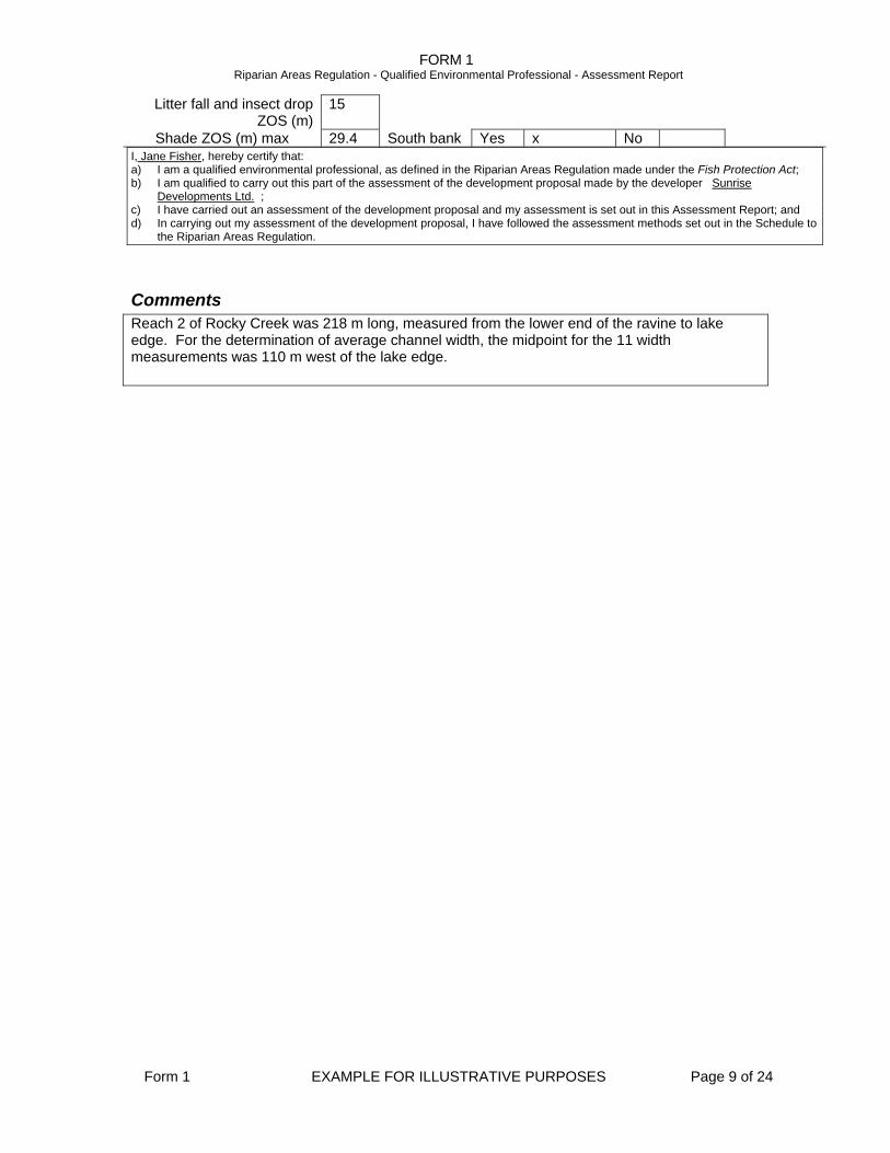
Comments Reach 2 of Rocky Creek was 218 m long, measured from the lower end of the ravine to lake edge. For the determination of average channel width, the midpoint for the 11 width measurements was 110 m west of the lake edge.
FORM 1 Riparian Areas Regulation - Qualified Environmental Professional - Assessment Report
Form 1 EXAMPLE FOR ILLUSTRATIVE PURPOSES Page 10 of 24
Refer to Chapter 3 of Assessment Methodology Date: 2006-08-11 Description of Water bodies involved (number, type) 3, stream & lake Stream Wetland Lake x Ditch
Number of reaches n/a Reach # n/a
Channel width and slope and Channel Type (use only if water body is a stream or a ditch, and only provide widths if a ditch)
Site Potential Vegetation Type (SPVT) Yes No SPVT Polygons x Tick yes only if multiple polygons, if No then fill in one set of SPVT data boxes I, Jane Fisher, hereby certify that:
a) I am a qualified environmental professional, as defined in the Riparian Areas Regulation made under the Fish Protection Act;
b) I am qualified to carry out this part of the assessment of the development proposal made by the developer Sunrise Developments Ltd.;
c) I have carried out an assessment of the development proposal and my assessment is set out in this Assessment Report; and
d) In carrying out my assessment of the development proposal, I have followed the assessment methods set out in the Schedule to the Riparian Areas Regulation.
Polygon No: n/a Method employed if other than TR LC SH TR SPVT Type x
Zone of Sensitivity (ZOS) and resultant SPEA Segment
No: A If two sides of a stream involved, each side is a separate segment. For all water
bodies multiple segments occur where there are multiple SPVT polygons LWD, Bank and Channel
Stability ZOS (m) 15
Litter fall and insect drop ZOS (m)
15
Shade ZOS (m) max 30 South bank Yes x No I, Jane Fisher, hereby certify that: a) I am a qualified environmental professional, as defined in the Riparian Areas Regulation made under the Fish Protection Act; b) I am qualified to carry out this part of the assessment of the development proposal made by the developer Sunrise
Developments Ltd.; c) I have carried out an assessment of the development proposal and my assessment is set out in this Assessment Report; and d) In carrying out my assessment of the development proposal, I have followed the assessment methods set out in the Schedule to
the Riparian Areas Regulation.
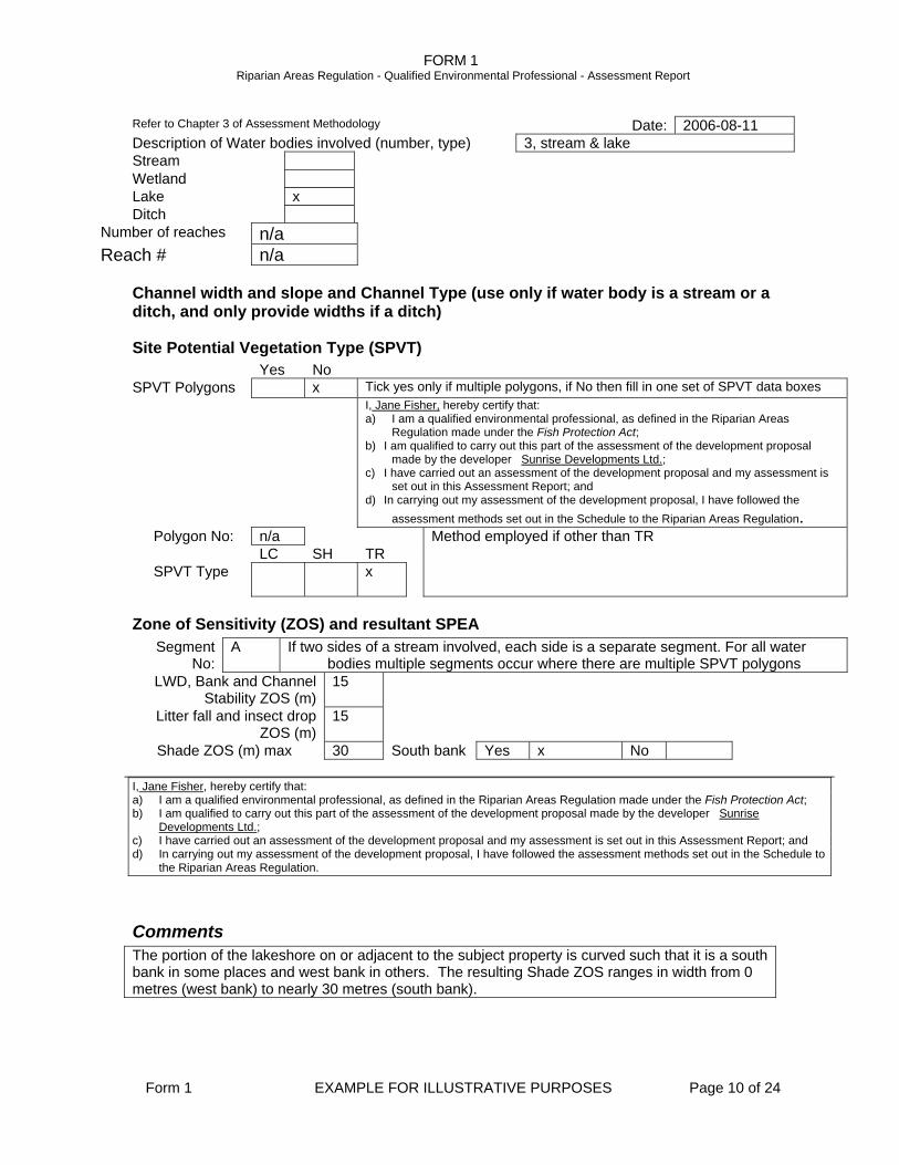
Comments The portion of the lakeshore on or adjacent to the subject property is curved such that it is a south bank in some places and west bank in others. The resulting Shade ZOS ranges in width from 0 metres (west bank) to nearly 30 metres (south bank).

FORM 1 Riparian Areas Regulation - Qualified Environmental Professional - Assessment Report
Form 1 EXAMPLE FOR ILLUSTRATIVE PURPOSES Page 11 of 24
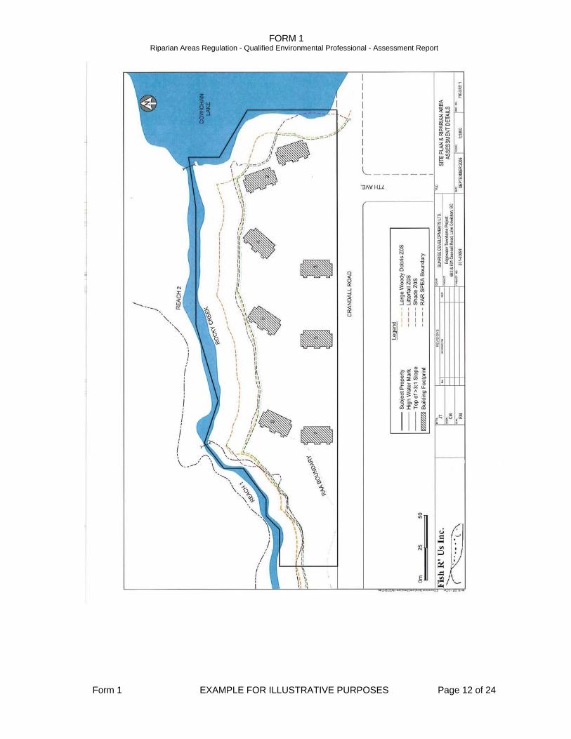
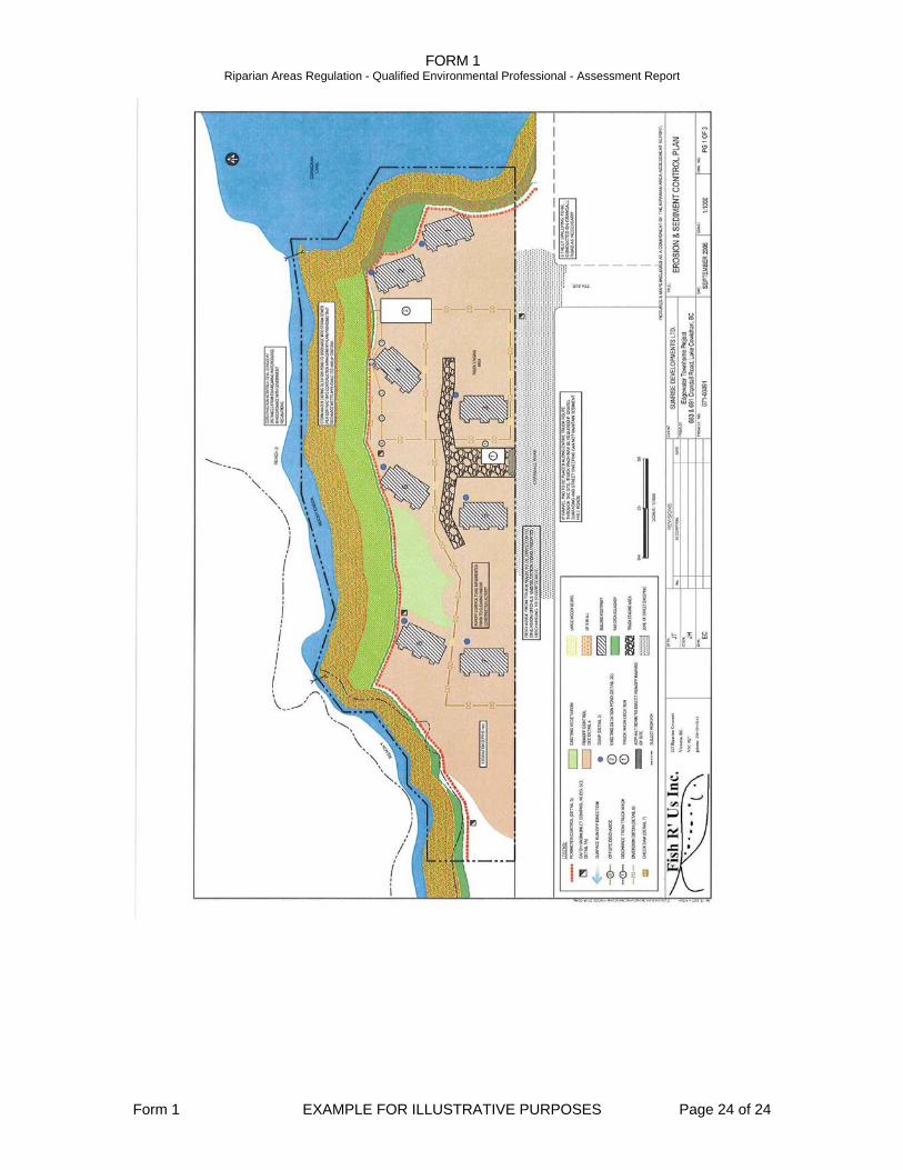
Section 3. Site Plan
Site Plan
FORM 1 Riparian Areas Regulation - Qualified Environmental Professional - Assessment Report
Form 1 EXAMPLE FOR ILLUSTRATIVE PURPOSES Page 12 of 24
FORM 1 Riparian Areas Regulation - Qualified Environmental Professional - Assessment Report
Form 1 EXAMPLE FOR ILLUSTRATIVE PURPOSES Page 13 of 24
Section 4. Measures to Protect and Maintain the SPEA 1. Danger Trees No danger trees were identified in the SPEA or wider Riparian Assessment Area. The entire subject property (and surrounding area) was logged approximately 28 years ago. The existing stands of trees are all young and the individual specimens all appear to be in good health. It is not anticipated that trees will need to be removed from the SPEA for human safety or property damage prevention purposes. If there are any trees of concern in the future, a qualified environmental professional needs to be obtained to confirm the tree(s) as a danger prior to any removal. I, Jane Fisher, hereby certify that: a) I am a qualified environmental professional, as defined in the Riparian Areas Regulation made under the Fish
Protection Act; b) I am qualified to carry out this part of the assessment of the development proposal made by the developer Sunrise
Developments Ltd.; c) I have carried out an assessment of the development proposal and my assessment is set out in this Assessment
Report; and In carrying out my assessment of the development proposal, I have followed the assessment methods set out in the Schedule to the Riparian Areas Regulation
2. Windthrow Windthrow can occur when areas of forest are opened up exposing previously sheltered trees to greater wind forces. While land clearing at the subject property will be required by the proposed development, the risk of windthrow damage to trees in the SPEA is considered to be very small. The proposed clearing will only expose SPEA trees to predominantly southerly winds, not the prevailing winter wind direction (the west). The SPEA trees will already be quite windfirm to winds from the south owing to the current low tree density in the area to be cleared and across Crandall Road further to the south. The tree cover in the SPEA itself is patchy and will act as natural feathering, further limiting the likelihood of windthrow damage.
I, Jane Fisher, hereby certify that: a. I am a qualified environmental professional, as defined in the Riparian Areas Regulation made under the Fish
Protection Act; b. I am qualified to carry out this part of the assessment of the development proposal made by the developer Sunrise
Developments Ltd.; c. I have carried out an assessment of the development proposal and my assessment is set out in this Assessment
Report; and In carrying out my assessment of the development proposal, I have followed the assessment methods set out in the Schedule to the Riparian Areas Regulation
3. Slope Stability See attached report, Slope Stability Analysis and Stormwater Management Recommendations for the Riparian Area Assessment at 683 & 691 Crandall Road, Lake Cowichan, BC, dated August 29, 2006
I, Polly Varden, hereby certify that: a. I am a qualified environmental professional, as defined in the Riparian Areas Regulation made under the Fish
Protection Act; b. I am qualified to carry out this part of the assessment of the development proposal made by the developer, Sunrise
Developments Ltd. ; c. I have carried out an assessment of the development proposal and my assessment is set out in this Assessment
Report; and In carrying out my assessment of the development proposal, I have followed the assessment methods set out in the Schedule to the Riparian Areas Regulation
FORM 1 Riparian Areas Regulation - Qualified Environmental Professional - Assessment Report
Form 1 EXAMPLE FOR ILLUSTRATIVE PURPOSES Page 14 of 24
4. Protection of Trees Since new construction is planned, it is important to take steps to protect trees within the SPEA. Even though no construction is planned in the SPEA, tree roots can extend outwards several times the height of the tree and can be easily damaged by construction activities. The SPEA will be flagged and fenced in advance of excavation activities at the site. In addition to the fencing of the SPEA the following precautions will be implemented at the subject property. Five of the proposed buildings will require excavation work and other construction activities to take place within 5 metres of the SPEA, but only in the vicinity of buildings 4 and 8 are there trees larger than 20 cm diameter at breast height. The fencing protecting the SPEA will be extended into the project site by five meters in the area of buildings 4 and 8 and during excavation work at buildings 4 and 8, a certified arborist will be present to ensure that no significant damage is done to the roots of SPEA trees in the area. The developer has been notified of this requirement. The developer has also been informed of a list of activities that must not take place near SPEA trees. These activities include:
• Changing the ground level around trees; • Allowing pollutants (i.e. concrete equipment wash-water) to contaminate the soil
around trees; • Moving or parking vehicles or excavation equipment around trees; and • Storing construction materials around trees.
An Environmental Monitor will be performing inspections and will be instructed to watch for practices that could jeopardize SPEA tree health. I, Jane Fisher, hereby certify that: a. I am a qualified environmental professional, as defined in the Riparian Areas Regulation made under the Fish
Protection Act; b. I am qualified to carry out this part of the assessment of the development proposal made by the developer Sunrise
Developments Ltd.; c. I have carried out an assessment of the development proposal and my assessment is set out in this Assessment
Report; and In carrying out my assessment of the development proposal, I have followed the assessment methods set out in the Schedule to the Riparian Areas Regulation
5. Encroachment Encroachment in the SPEA, often by residents of adjacent property, is a major cause of riparian loss and stream degradation. Plant loss due to trampling of vegetation near a stream increases silting of spawning gravels and reduces the abundance of sensitive aquatic invertebrates that are important fish food sources. The developer understands that access to Rocky Creek needs to be restricted, even for residents of the proposed housing complex. It is proposed that access to Rocky Creek from the proposed development will be prevented by a combination of split rail fencing, landscape planting and signage. The developer would like to provide residents opportunity for viewing the ravine portion of Rocky Creek from a location just outside the proposed SPEA. The topography of the site west of building 8 would allow for a narrow (<1.2 metre) pervious-surfaced path to lead to a knoll near the top of the >3:1 slope at the ravine top. The land surface in the vicinity slopes downhill to the east, away from the ravine, ensuring that any sediment laden waters running off the trail would be directed away from Rocky Creek. The knoll viewing area would be fenced to prevent entry into the SPEA. Encroachment on the SPEA from Crandall Road, east of 7th Avenue is a concern. There is an informal trail leading from the east end of Crandall Road, north along the shoreline of Cowichan Lake to a rocky outcrop at the mouth of Rocky Creek. Most of this informal trail is outside the subject property and accessible for much of the year (late summer to mid winter) when the lake level is well below the high water level and a wide band of shoreline exists outside the subject property. While it is not the responsibility to of the developer to regulate activities outside the subject property, signage will be developed and deployed to the southeast corner of the subject
FORM 1 Riparian Areas Regulation - Qualified Environmental Professional - Assessment Report
Form 1 EXAMPLE FOR ILLUSTRATIVE PURPOSES Page 15 of 24
property, requesting that the public respect the sensitive nature of the riparian habitat and keep off it. I, Jane Fisher, hereby certify that: a. I am a qualified environmental professional, as defined in the Riparian Areas Regulation made under the Fish
Protection Act; b. I am qualified to carry out this part of the assessment of the development proposal made by the developer Sunrise
Developments Ltd.; c. I have carried out an assessment of the development proposal and my assessment is set out in this Assessment
Report; and In carrying out my assessment of the development proposal, I have followed the assessment methods set out in the Schedule to the Riparian Areas Regulation
6. Sediment and Erosion Control
See attached report, Recommendations for Sediment & Erosion Control 683 & 691 Crandall Road, Lake Cowichan, BC, dated August 21, 2006.
I, Ted Grayling, hereby certify that: a. I am a qualified environmental professional, as defined in the Riparian Areas Regulation made under the Fish
Protection Act; b. I am qualified to carry out this part of the assessment of the development proposal made by the developer Sunrise
Developments Ltd.; c. I have carried out an assessment of the development proposal and my assessment is set out in this Assessment
Report; and In carrying out my assessment of the development proposal, I have followed the assessment methods set out in the Schedule to the Riparian Areas Regulation
7. Stormwater Management See attached report, Slope Stability Analysis and Stormwater Management Recommendations for the Riparian Area Assessment at 683 & 691 Crandall Road, Lake Cowichan, BC, dated August 29, 2006
I, Polly Varden, hereby certify that: a. I am a qualified environmental professional, as defined in the Riparian Areas Regulation made under the Fish
Protection Act; b. I am qualified to carry out this part of the assessment of the development proposal made by the developer Sunrise
Developments Ltd.; c. I have carried out an assessment of the development proposal and my assessment is set out in this Assessment
Report; and In carrying out my assessment of the development proposal, I have followed the assessment methods set out in the Schedule to the Riparian Areas Regulation
8. Floodplain Concerns (highly mobile channel)
During the site reconnaissance there was no evidence to indicate that Rocky Creek has a floodplain beyond the HWM observed. Recent changes to the hydrology of the upstream portion of Rocky Creek have exerted a significant stress on the lower portion of the creek and if the channel was prone to mobility it would be evident at this point. It is concluded that channel mobility will not negatively impact the SPEA. I, Jane Fisher, hereby certify that: a. I am a qualified environmental professional, as defined in the Riparian Areas Regulation made under the Fish
Protection Act; b. I am qualified to carry out this part of the assessment of the development proposal made by the developer Sunrise
Developments Ltd.; c. I have carried out an assessment of the development proposal and my assessment is set out in this Assessment
Report; and In carrying out my assessment of the development proposal, I have followed the assessment methods set out in the Schedule to the Riparian Areas Regulation
FORM 1 Riparian Areas Regulation - Qualified Environmental Professional - Assessment Report
Form 1 EXAMPLE FOR ILLUSTRATIVE PURPOSES Page 16 of 24
Section 5. Environmental Monitoring A QEP will be retained as project environmental monitor by Sunrise Developments Ltd. The environmental monitor will be available for quick response to emergencies such as drainage problems due to significant rainfall events. The QEP will be experienced in sediment and erosion control and will have the authority to stop work if necessary to protect the SPEA. Monitoring will be carried out to ensure:
• All development activities remain outside the SPEA; • All Tree Protection measures are being followed; • Protective structures (i.e. fencing and silt barriers) are in good working order; • Stormwater management structures are working.
Site visits will be approximately weekly while site preparation and utility installation work is ongoing. After the building foundations are backfilled, inspection frequency will be timed to key construction activities (i.e. landscape grading, paving) and based on weather conditions (i.e. during/after periods of high rainfall). Final monitoring will review the effectiveness of stormwater management structures. The developer has also been informed of their requirement to have a QEP complete and file a post-development report and arrangements have been made to ensure that this takes place. This report will indicate whether or not the above measures were implemented, and how effective they were at protecting the integrity of the SPEA.
FORM 1 Riparian Areas Regulation - Qualified Environmental Professional - Assessment Report
Form 1 EXAMPLE FOR ILLUSTRATIVE PURPOSES Page 17 of 24
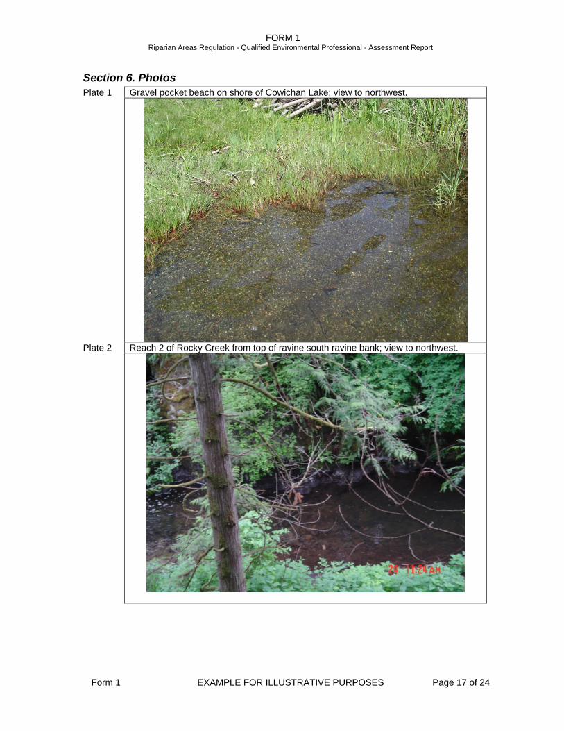
Section 6. Photos Plate 1 Gravel pocket beach on shore of Cowichan Lake; view to northwest.
Plate 2 Reach 2 of Rocky Creek from top of ravine south ravine bank; view to northwest.
FORM 1 Riparian Areas Regulation - Qualified Environmental Professional - Assessment Report
Form 1 EXAMPLE FOR ILLUSTRATIVE PURPOSES Page 18 of 24
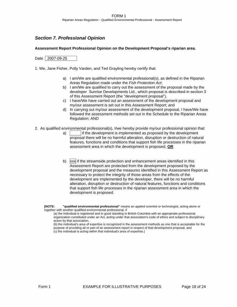
Section 7. Professional Opinion
Assessment Report Professional Opinion on the Development Proposal’s riparian area.
Date 2007-09-25
1. We, Jane Fisher, Polly Varden, and Ted Grayling hereby certify that:
a) I am/We are qualified environmental professional(s), as defined in the Riparian Areas Regulation made under the Fish Protection Act;
b) I am/We are qualified to carry out the assessment of the proposal made by the developer Sunrise Developments Ltd., which proposal is described in section 3 of this Assessment Report (the “development proposal”),
c) I have/We have carried out an assessment of the development proposal and my/our assessment is set out in this Assessment Report; and
d) In carrying out my/our assessment of the development proposal, I have/We have followed the assessment methods set out in the Schedule to the Riparian Areas Regulation; AND
2. As qualified environmental professional(s), I/we hereby provide my/our professional opinion that: a) if the development is implemented as proposed by the development
proposal there will be no harmful alteration, disruption or destruction of natural features, functions and conditions that support fish life processes in the riparian assessment area in which the development is proposed, OR
b) xxx if the streamside protection and enhancement areas identified in this Assessment Report are protected from the development proposed by the development proposal and the measures identified in this Assessment Report as necessary to protect the integrity of those areas from the effects of the development are implemented by the developer, there will be no harmful alteration, disruption or destruction of natural features, functions and conditions that support fish life processes in the riparian assessment area in which the development is proposed.
[NOTE: "qualified environmental professional" means an applied scientist or technologist, acting alone or together with another qualified environmental professional, if
(a) the individual is registered and in good standing in British Columbia with an appropriate professional organization constituted under an Act, acting under that association's code of ethics and subject to disciplinary action by that association, (b) the individual's area of expertise is recognized in the assessment methods as one that is acceptable for the purpose of providing all or part of an assessment report in respect of that development proposal, and (c) the individual is acting within that individual's area of expertise.]
FORM 1 Riparian Areas Regulation - Qualified Environmental Professional - Assessment Report
Form 1 EXAMPLE FOR ILLUSTRATIVE PURPOSES Page 19 of 24
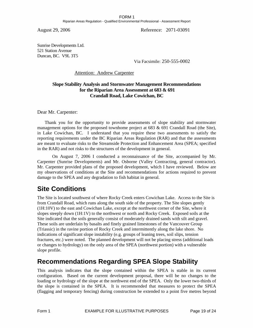
August 29, 2006 Reference: 2071-03091
Sunrise Developments Ltd. 521 Station Avenue Duncan, BC. V9L 3T5 Via Facsimile: 250-555-0002
Attention: Andrew Carpenter
Slope Stability Analysis and Stormwater Management Recommendations for the Riparian Area Assessment at 683 & 691
Crandall Road, Lake Cowichan, BC
Dear Mr. Carpenter:
Thank you for the opportunity to provide assessments of slope stability and stormwater management options for the proposed townhome project at 683 & 691 Crandall Road (the Site), in Lake Cowichan, BC. I understand that you require these two assessments to satisfy the reporting requirements under the BC Riparian Areas Regulation (RAR) and that the assessments are meant to evaluate risks to the Streamside Protection and Enhancement Area (SPEA; specified in the RAR) and not risks to the structures of the development in general.
On August 7, 2006 I conducted a reconnaissance of the Site, accompanied by Mr. Carpenter (Sunrise Developments) and Mr. Osborne (Valley Contracting, general contractor). Mr. Carpenter provided plans of the proposed development, which I have reviewed. Below are my observations of conditions at the Site and recommendations for actions required to prevent damage to the SPEA and any degradation to fish habitat in general.
Site Conditions The Site is located southwest of where Rocky Creek enters Cowichan Lake. Access to the Site is from Crandall Road, which runs along the south side of the property. The Site slopes gently (1H:10V) to the east and Cowichan Lake, except at the northwest corner of the Site, where it slopes steeply down (1H:1V) to the northwest or north and Rocky Creek. Exposed soils at the Site indicated that the soils generally consist of moderately drained sands with silt and gravel. These soils are underlain by basalts and finely grained limestones of the Vancouver Group (Triassic) in the ravine portion of Rocky Creek and intermittently along the lake shore. No indications of significant slope instability (e.g. groups of leaning trees, soil slips, tension fractures, etc.) were noted. The planned development will not be placing stress (additional loads or changes to hydrology) on the only area of the SPEA (northwest portion) with a vulnerable slope profile.
Recommendations Regarding SPEA Slope Stability This analysis indicates that the slope contained within the SPEA is stable in its current configuration. Based on the current development proposal, there will be no changes to the loading or hydrology of the slope at the northwest end of the SPEA. Only the lower two-thirds of the slope is contained in the SPEA. It is recommended that measures to protect the SPEA (flagging and temporary fencing) during construction be extended to a point five metres beyond
FORM 1 Riparian Areas Regulation - Qualified Environmental Professional - Assessment Report
Form 1 EXAMPLE FOR ILLUSTRATIVE PURPOSES Page 20 of 24
the top of the >3:1 slope line. This will ensure that temporary stresses such as soil stockpiling or the discharge of de-watering pumps will not be placed on this slope.
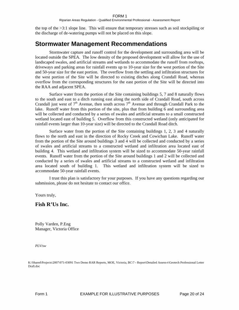
Stormwater Management Recommendations Stormwater capture and runoff control for the development and surrounding area will be
located outside the SPEA. The low density of the proposed development will allow for the use of landscaped swales, and artificial streams and wetlands to accommodate the runoff from rooftops, driveways and parking areas for rainfall events up to 10-year size for the west portion of the Site and 50-year size for the east portion. The overflow from the settling and infiltration structures for the west portion of the Site will be directed to existing ditches along Crandall Road, whereas overflow from the corresponding structures for the east portion of the Site will be directed into the RAA and adjacent SPEA.
Surface water from the portion of the Site containing buildings 5, 7 and 8 naturally flows to the south and east to a ditch running east along the north side of Crandall Road, south across Crandall just west of 7th Avenue, then south across 7th Avenue and through Crandall Park to the lake. Runoff water from this portion of the site, plus that from building 6 and surrounding area will be collected and conducted by a series of swales and artificial streams to a small constructed wetland located east of building 5. Overflow from this constructed wetland (only anticipated for rainfall events larger than 10-year size) will be directed to the Crandall Road ditch.
Surface water from the portion of the Site containing buildings 1, 2, 3 and 4 naturally flows to the north and east in the direction of Rocky Creek and Cowichan Lake. Runoff water from the portion of the Site around buildings 3 and 4 will be collected and conducted by a series of swales and artificial streams to a constructed wetland and infiltration area located east of building 4. This wetland and infiltration system will be sized to accommodate 50-year rainfall events. Runoff water from the portion of the Site around buildings 1 and 2 will be collected and conducted by a series of swales and artificial streams to a constructed wetland and infiltration area located south of building 1. This wetland and infiltration system will be sized to accommodate 50-year rainfall events.
I trust this plan is satisfactory for your purposes. If you have any questions regarding our submission, please do not hesitate to contact our office.
Yours truly,
Fish R’Us Inc.
Polly Varden, P.Eng Manager, Victoria Office PLV/sw
K:\Shared\Projects\2007\071-03091 Two Demo RAR Reports, MOE, Victoria, BC\7 - Report\Detailed Assess-t\Geotech Professional Letter
Draft.doc
FORM 1 Riparian Areas Regulation - Qualified Environmental Professional - Assessment Report
Form 1 EXAMPLE FOR ILLUSTRATIVE PURPOSES Page 21 of 24
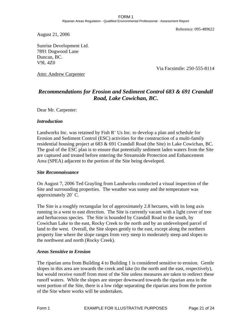
Reference: 095-489622 August 21, 2006 Sunrise Development Ltd. 7891 Dogwood Lane Duncan, BC. V9L 4Z0
Via Facsimile: 250-555-8114 Attn: Andrew Carpenter Recommendations for Erosion and Sediment Control 683 & 691 Crandall
Road, Lake Cowichan, BC. Dear Mr. Carpenter: Introduction Landworks Inc. was retained by Fish R’ Us Inc. to develop a plan and schedule for Erosion and Sediment Control (ESC) activities for the construction of a multi-family residential housing project at 683 & 691 Crandall Road (the Site) in Lake Cowichan, BC. The goal of the ESC plan is to ensure that potentially sediment laden waters from the Site are captured and treated before entering the Streamside Protection and Enhancement Area (SPEA) adjacent to the portion of the Site being developed. Site Reconnaissance On August 7, 2006 Ted Grayling from Landworks conducted a visual inspection of the Site and surrounding properties. The weather was sunny and the temperature was approximately 20` C. The Site is a roughly rectangular lot of approximately 2.8 hectares, with its long axis running in a west to east direction. The Site is currently vacant with a light cover of tree and herbaceous species. The Site is bounded by Crandall Road to the south, by Cowichan Lake to the east, Rocky Creek to the north and by an undeveloped parcel of land to the west. Overall, the Site slopes gently to the east, except along the northern property line where the slope ranges from very steep to moderately steep and slopes to the northwest and north (Rocky Creek). Areas Sensitive to Erosion The riparian area from Building 4 to Building 1 is considered sensitive to erosion. Gentle slopes in this area are towards the creek and lake (to the north and the east, respectively), but would receive runoff from most of the Site unless measures are taken to redirect these runoff waters. While the slopes are steeper downward towards the riparian area in the west portion of the Site, there is a low ridge separating the riparian area from the portion of the Site where works will be undertaken.
FORM 1 Riparian Areas Regulation - Qualified Environmental Professional - Assessment Report
Form 1 EXAMPLE FOR ILLUSTRATIVE PURPOSES Page 22 of 24
Erosion and Sediment Control Recommended ESC measures include perimeter control until depth of excavations reaches 0.5 metres below grade, (ie. construction fence boundary, compost filter sock, silt fence and/or concrete barricades), runoff control (ie. swales, check dams, polyethylene sheeting coverage, straw bales, seeding, and/or mulching), and sedimentation control (dust control during summer construction, and/or water filtration/sediment pond system options). As the Cowichan Valley Regional District does not have discharge criteria in place, discharge leaving the Site must meet criteria of the Ministry of Environment (MoE) for both Total Suspended Solids (TSS) and pH. Discharge leaving the Site must have a pH from 6.5 to 9.0. Since there is no pre-existing flow from the property, MoE discharge criteria for TSS will apply. These are a maximum of 25 mg/L in any sample, or a mean of 5 mg/L in five samples taken over a 30 day period. Runoff Control Vegetation is to remain intact as long as possible. Vegetation within the SPEA boundary, as per the Riparian Areas Regulation, is to be 100% retained. In the event of heavy precipitation periods where naturally occurring erosion controls are overwhelmed, additional measures will be needed such as a settling pond. Slopes/soil stockpiles to be exposed are longer than two to three days are to be covered with polyethylene lining. Swales will be installed perpendicular to slopes for the catchment of storm runoff and water redirected to the sediment pond for settlement treatment. Sedimentation Control Stabilized driveway access routes are required to minimize erosion and to prevent the off-site tracking of mud. Gravel pads of ¾ inch clear crush and 3 inches thick are recommended at the site entrance and exit. Water leaving the Site should be allowed to settle to remove TSS and pH adjusted if necessary before discharge. Dust Control During dry periods of construction, dust control may be required to prevent dried sediments from the being blown into the creek and/or lake. The use of angular fock access ways and construction roads will minimize the development of dust, but dust control may still be necessary. Dust control may be accomplished by the controlled sprinkling of exposed soils with water. No significant runoff is to be generated. Expert Advice
FORM 1 Riparian Areas Regulation - Qualified Environmental Professional - Assessment Report
Form 1 EXAMPLE FOR ILLUSTRATIVE PURPOSES Page 23 of 24
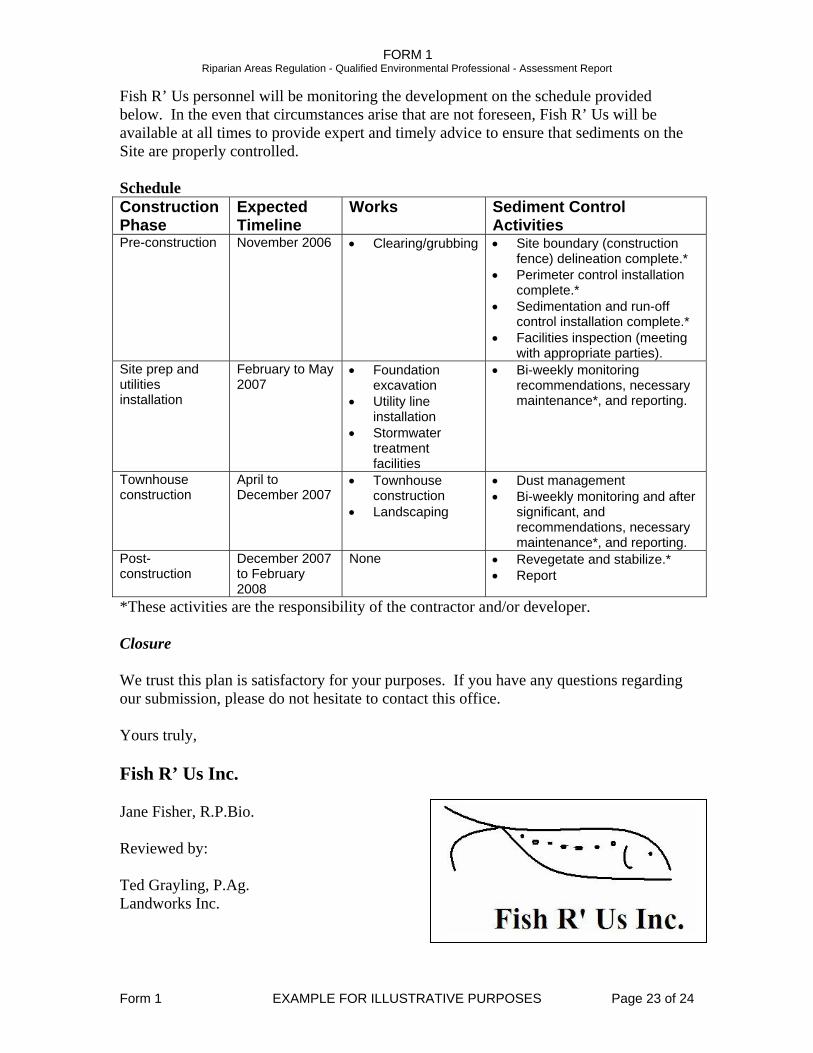
Fish R’ Us personnel will be monitoring the development on the schedule provided below. In the even that circumstances arise that are not foreseen, Fish R’ Us will be available at all times to provide expert and timely advice to ensure that sediments on the Site are properly controlled. Schedule Construction Phase
Expected Timeline
Works Sediment Control Activities
Pre-construction November 2006 • Clearing/grubbing • Site boundary (construction fence) delineation complete.*
• Perimeter control installation complete.*
• Sedimentation and run-off control installation complete.*
• Facilities inspection (meeting with appropriate parties).
Site prep and utilities installation
February to May 2007
• Foundation excavation
• Bi-weekly monitoring recommendations, necessary maintenance*, and reporting. • Utility line
installation • Stormwater
treatment facilities
Townhouse construction
April to December 2007
• Townhouse construction
• Dust management • Bi-weekly monitoring and after
significant, and recommendations, necessary maintenance*, and reporting.
• Landscaping
Post-construction
December 2007 to February 2008
None • Revegetate and stabilize.* • Report
*These activities are the responsibility of the contractor and/or developer. Closure We trust this plan is satisfactory for your purposes. If you have any questions regarding our submission, please do not hesitate to contact this office. Yours truly, Fish R’ Us Inc. Jane Fisher, R.P.Bio. Reviewed by: Ted Grayling, P.Ag. Landworks Inc.
FORM 1 Riparian Areas Regulation - Qualified Environmental Professional - Assessment Report
Form 1 EXAMPLE FOR ILLUSTRATIVE PURPOSES Page 24 of 24


![[Archive] A System for Mapping Riparian Areas in the](https://img.pdfslide.net/doc/110x75/627eb78a753cc02f814cfcb6/archive-a-system-for-mapping-riparian-areas-in-the-.jpg)

