Embed Size (px)
Citation preview
Lamontagne Geophysics Lamontagne Geophysics
LAMONTAGNE GEOPHYSICS LTD20 Binnington Court, Kingston, Ontario, Canada K7M 8S3 _Tel: 613-531-9950 _Fax: 613-531-8987 www.lamontagnegeophysics.com/
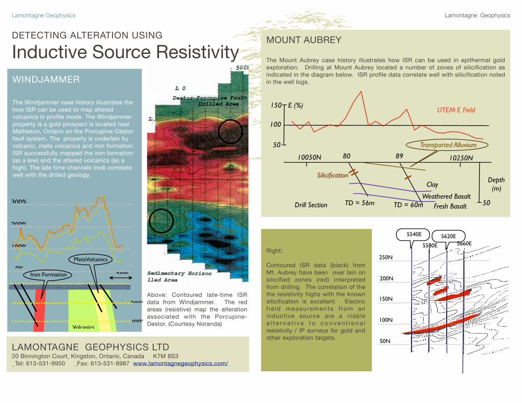
WINDJAMMER
The Windjammer case history illustrates the how ISR can be used to map altered volcanics in profile mode. The Windjammer property is a gold prospect is located near Matheson, Ontario on the Porcupine-Destor fault system. The property is underlain by volcanic, meta volcanics and iron formation. ISR successfully mapped the iron formation (as a low) and the altered volcanics (as a high). The late time channels (red) correlate well with the drilled geology.
200%
300%
40 43
400’
200’
Volcanics
Iron Formation
MetaVolcanics
200’
100%
0%
DETECTING ALTERATION USING
Inductive Source Resistivity
Above: Contoured late-time ISR data from Windjammer. The red areas (resistive) map the alteration associated with the Porcupine-Destor. (Courtesy Noranda)
250N
200N
150N
100N
50N
5540E
5580E
5620E5660E
Right: Contoured ISR data (black) from Mt. Aubrey have been over lain on silicified zones (red) interpreted from drilling. The correlation of the the resistivity highs with the known silicification is excellent. Electric f i e ld measurements f rom an inductive source are a viable a l t e r n a t i v e t o c o n v e n t i o n a l resistivity / IP surveys for gold and other exploration targets.
MOUNT AUBREY
The Mount Aubrey case history illustrates how ISR can be used in epithermal gold exploration. Drilling at Mount Aubrey located a number of zones of silicification as indicated in the diagram below. ISR profile data correlate well with silicification noted in the well logs.
UTEM E Field
Depth (m)
Drill Section TD = 56m TD = 60m
E (%)
Transported Alluvium
Clay
Weathered BasaltFresh Basalt
10050N 10250N 80 89
150
50
100
Silicification
50
Lamontagne Geophysics Lamontagne Geophysics
New Developments in ISRInductive Source Resistivity: Shea Creek TestDetecting Alteration at depth in the Athabasca
ISR Survey layout
Line 7200N was selected for surveying because of its proximity to the Kianna and Anne zones. Ex - the in-line component of the electric field - was measured from four 2000x2000m ungrounded transmitter loops:
Loop 1 - offset 400m gridnorthLoop 2 - offset 800m gridnorthLoop 3 - offset 1200m gridnorthLoop 4 - offset 1600m gridnorth
E-field measurements were collected with standard electrode dipoles - in -40° weather.
ISR Survey Setting (Nimeck and Koch, 2008)
The Shea Creek deposit is in the western part of the Athabasca Basin, approximately 15km south of the Cluff Lake Mine which is within the Carswell Structure. The Shea Creek deposit consists of three mineralized uranium zones (Anna, Kianna and Colette) that are on a long-strike-length NNW trending graphitic conductor - termed the Saskatoon Lake Conductor (SLC).
A distinctive zone of low resistivity associated with the three mineralized zones extends approximately 300m above the unconformity. This zone is interpreted to reflect regions affected by structural reactivation and possible associated hydrothermal alteration processes resulting in increased sandstone porosity
Mineralization is found in three locations: - perched within the Athabasca sandstone- at the unconformity (~710-750m)- below the unconformity within the basement units
ISR Survey
A UTEM Induced Source Resistivity (ISR) test was carried out in late November 2006 over the Shea Creek deposit to test the ability of the ISR method to detect the presence of the associated alteration. The survey also serves to showcase the depth penetration of ISR.
115 Grant Timmins Drive, Kingston, Ontario, Canada K7M 8N3Tel: (1) 613.531.9950 Fax: (1) 613.531.8987 [email protected] GEOPHYSICS LTD
GEOPHYSIQUE LTEE
Annotated ISR Section - discussion
The L7200N ISR Section is presented above with annotations.
A number of features are evident in the section but two stand out in particular:
There is an anomalous low resistivity feature in the ISR section at the trace of the Saskatoon Lake Conductor - ~500W - and at a depth-to-top of ~450m. This is in the sandstone roughly 300m above the unconformity.
The UTEM ISR (Induced Source Resistivity) feature is coincident with the zone of low resistivity interpreted to reflect the top of the structural reactivation/alteration overlying the Kianna and the
Anne zones.
The ISR section is cropped at 2000m but features are clearly traceable to that depth - and deeper.
This indicates the potential of UTEM ISR (Induced Source Resistivity) to map features at considerable depth.
trace ofSaskatoon Lake
Conductor
EastBasement
Block
WestBasement
Block
~Unconformity~
Shea Creek L7200N
inferred low resistivity in Sandstone
possible alteration zones
ContactFeature
100000
10162540
630963981125119158491000069103881251215851000
63
251
100
390631
6.9
158
lowresistivity
highresistivity
?
|1000W
|500W
|500E
|BL 0
|1000E
0
-2000
-1500
-1000
-500
-250
-750
-1250
-1750
0
-2000
-1500
-500
-250
-750
-1250
-1750
ResistivityOhm-m
1000W|
500W|
500E|
BL 0|
1000E|
Sandstone
Surficial conductive patches
(depolarization effect)
Annotated ISR SectionShea Creek L7200N
For more information, please visit us at PDAC booth 1103
115 Grant Timmins Drive, Kingston, Ontario, Canada K7M 8N3Tel: (1) 613.531.9950 Fax: (1) 613.531.8987 [email protected] GEOPHYSICS LTD
GEOPHYSIQUE LTEE
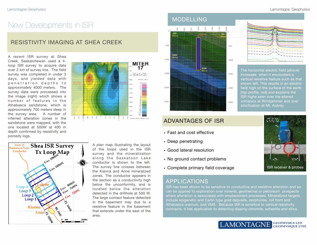
A plan map illustrating the layout of the loops used in the ISR survey and the mineralization a l o n g t h e S a s k a t o o n L a k e conductor is shown to the left. The survey line crosses between the Kianna and Anne mineralized zones. The conductor appears in the section as a conductivity high below the unconformity, and is located below the alterat ion detected in the drillhole at 500 W. The large contact feature detected in the basement may due to a resistive feature in the basement that extends under the east of the area.
ADVANTAGES OF ISR
• Fast and cost effective
• Deep penetrating
• Good lateral resolution
• No ground contact problems
• Complete primary field coverage
APPLICATIONS ISR has been shown to be sensitive to conductive and resistive alteration and so can be applied to exploration over mineral, geothermal or petroleum prospects where alteration is associated with emplacement processes. Mineralized targets include epigenetic and Carlin type gold deposits, porphyries, roll front and Athabasca uranium, and VMS. Because ISR is sensitive to vertical resistivity contracts, it has application to detecting dipping chromite, scheelite and silica
The horizontal electric field (above) increases when it encounters a vertical resistive feature such as that shown left. This results in an electric field high on the surface of the earth (top profile, red) and explains the ISR highs seen over the altered volcanics at Windjammer and over silicification at Mt. Aubrey
MODELLING
ISR receiver & probes
A recent ISR survey at Shea Creek, Saskatchewan used a 4-loop ISR survey to acquire data over 2 km of survey line. The field survey was completed in under 3 days, and yielded data with p e n e t r a t i o n d e p t h s t o approximately 4000 meters. The survey data were processed into the image (right) which shows a n u m b e r o f f e a t u re s i n t h e Athabasca sandstone, which is approximately 700 meters deep in the survey area. A number of inferred alteration zones in the sandstone were mapped, with the one located at 500W at 400 m depth confirmed by resistivity and porosity logs.
RESISTIVITY IMAGING AT SHEA CREEK