Embed Size (px)
Citation preview
Egyptian Computer Science Journal Vol. 41 No.3 September 2017 ISSN-1110-2586
-1-
Developing a Spatial Decision Support System Model for Enhancing
Highways Emergency Services in Egypt
Nanis Nabil Mohamed, Christina Albert Rayed
Computer and Information System Department, Sadat Academy for Management Science,
Cairo, Egypt
[email protected], [email protected]
Abstract
Today's SDSS has developed in many areas, special for emergency medical services
that are very important component for the highways emergency services a particular in
developing countries. In orders to safe and rapidly transported to the hospitals in all critical cases.
Also, GIS is used in Transportation Asset Management (TAM); which includes the
transportation planning and emergency services management that help in determining the
measurement, area, optimized shortest path and spatial analysis.
The objective of this paper is to build Spatial Decision Support System (SDSS) model
for enhancing highways emergency services. It not only for identifying the shortest path, but
is to find the accident location automatically without intervention of the human factor. Using
SDSS to reach injured rapidly from the incident site to the nearest general hospital that
included all branches. Design and Develop a Case study by applying the model in the capital
of Egypt in the greater Cairo especially the Ring road.
Results coming from using this model are finding the accident occurred by sending
alarm to the nearest ambulance. Then, this model calculates the elapsed time for each route.
Also, choosing the best route according to the low traffic; from the ambulance location to the
accident site, and from the accident site to the nearest hospital or simply determine the
shortest path.
Keywords: GIS (Geographic Information System), TAM (Transportation Asset Management),
SDSS (Spatial Decision Support System), AMS (Ambulance Management System),
DSS (Decision Support System), GPS (Global Positioning System), API
(Application Program Interface).
1. Introduction
GIS has the ability to communicate with other programs. By using GIS in highways
emergency services, can provide us a lot of information about people and accidents in order to
rescue the trapped victims. Emergency service is the main component of emergency
healthcare. It can be accomplished by the efficient management of ambulance and reducing
ambulance response time, so it can help patients or injured transported to hospital rapidly [1].
Using GIS in Transportation Asset Management (TAM) for modeling the transport area
traffic analysis generation, this analysis can help in determining the sizes and area
optimization and geography. Also it can determine the traffic zone which can be tested easily
with GIS [2]. So, SDSS has developed in many areas including transportation planning and
emergency management [3]. SDSS used in all stages of decision making process to choose
the site as follows; raw assist decision making process and public information, consultation

Egyptian Computer Science Journal Vol. 41 No.3 September 2017 ISSN-1110-2586
-2-
and participation, support decision making in the public inquiry. Also SDSS has the ability to
simulate the movement of passengers for different modes of transport and alternative routes [4].
Today's GIS technology is increasingly being used in many fields of planning and
research. The application of GIS has become increasingly designed and evaluated of
healthcare programs [5]. Besides, SDSS is explicitly designed to provide the user with a
decision making environment that enables analysis of GIS carried out in flexible manner.
These systems have evolved in parallel with decision support system developed for business
applications [6].
Ambulance management system (AMS), is designed by analyzing the ground situation,
for example the problems faced by the emergency service providers like hospitals during
transport of a patient. AMS plays a significant role in solving routing problem of an
ambulance, on the road network when need arises to transport a patient to the nearest hospital.
AMS solve ambulance problem, like fastest routing of an ambulance using GPS. It also
analyzed roads interrupted by the congestion and other activities during peak hours and
calculates the fastest route. Also AMS is capable of handling multi accident situation [7].
2. Objective of developing a spatial decision support system model
The main objective of this paper is to build a Spatial Decision Support System Model
for enhancing emergency roads. So, according to this model we need to achieve the following
goals:
1. Setting on a map of ambulance position and hospital location;
2. Ambulance districting: GIS will take into consideration the data concerning the road
network and hospital location;
3. Finding the site location based on alarm on the emergency ambulance to make the
ambulance driver know where the incident site is automatically using SDSS. And
there are two factors that will affect choosing the appropriate ambulance: A.
Ambulance position B. Traffic type
4. Using GIS tools to determine the hospitals that are closest to the injured area
3. Using SDSS in Transportation Asset Management (TAM)
Using geographic information system (GIS) to store and analyze spatial information.
GIS gives more focus on the analysis of geographic information, in contrast with the systems
of painting or other management more oriented representation of geographic data or storage
[7]. Other uses include Geographic Information System for modeling the transport area
traffic analysis traffic generation transport network [2].
GIS transportations have many fields such as Transport planning alternative, The
development of bus lines, Planning emergency dispatch and road, Management of the Fleet,
Location systems reference, Package and Delivery Services, Clear the roads and engineering,
Street banners, Traffic counts , Modeling of Traffic Demand, Stock Intersection [8]. Network
analysis is a set of analysis techniques used with networks and the use of databases of the
network. Also, through network analysis you can analyze the routes and service areas, closest
facility point of origin [9].
Global Positioning system was used the satellite data to calculate the precise position on
the ground [10]. The uses of SDSS in general is strongly integrates the application of

Egyptian Computer Science Journal Vol. 41 No.3 September 2017 ISSN-1110-2586
-3-
transportation with housing, economic development and community and Urban Planning, it
allows the database system to manage spatial data [11].
The uses of SDSS in emergency, the SDSS can be used to improve transport policies
and investments line agencies different such as roads, highways management, used to
evaluate transport projects and policies proposed for the fourth five-year plan, and also the support of the World Bank in the formulation of long-term, transport policies multi-patterns[12].
Examples of problem solving using the SDSS, such as the generation of the control
optimization for several problems of guidance control involving the service demand located
along arcs of a transportation network, the implementation of multi-way decision support
system spatial multi-vehicle efficiency of trash collection [13]. In the future, will extend the
application of the SDSS conventional for a large number of potential applications where the
spatial information is only a temporary stage or a subset of the information needed for
decision-making [14].
4. Crises and disaster reduction models in Developing Countries
Many researches and studies have been carried throughout the world regarding
development of Information system using GIS, DSS, and SDSS during years. Some of the
literatures referred for the study and considered as prime importance has been highlighted.
4.1 Disaster reduction and emergency models using GIS
Ric Skinner used GIS to manage how he can analyze emergency plan response for
operating picture for integrated emergency medical services and hospital emergency
management response [15]. Also, Salah Bhratha used GIS for making an analytical model to
manage ambulance response time. And, also, he uses a statistical model for making a GIS
framework to evaluate the ambulance response performance [16].
According to, Christophert. Emrich, Susan L. Culter and Paul J. Weschler made a
conceptual model of GIS and how it interacts with each phase (Preparedness, Mitigation,
Recovery and Response) [17]. Also, T J Cova said that hoemter define emergency
management as discipline and profession of applying science, planning and management to
deal with huge events that can injure or kill a huge number of people [18]. Then, T J Cova
identify that within emergency management you can know where an event is occurring to
minimize losses of lives [18].
So, all of these researchers used GIS in emergency in different fields. Therefore, there
are many writers using DSS in emergency management. Like V. Bhanumurthy, Vinod M.
Bothale, Brajesh Kumar, Nehaur Kude and Reedhi Shukla talking about emergency specified
directing disaster that requires an available facility to rescue in operation in a minimum of
time. So, they know the shortest path between the event of disaster and the location in near
real time. And, they also focus on the writer D I Jkstra algorithm for finding the shortest path [19].
4.2 Emergency models using DSS
Ashraf Gubara, Ali Amasha, Zakaria Ahmed and Shawki El Ghazali said that the main
criterion to immediate response for any emergency response provider and DSS is
preparedness [20]. Also, they make a system of emergency response can be used also in fire
emergency and police station system. They used emergency DSS to reduce disaster losses and
improve efficiency of resources allocation in emergency situation. They made a portal system
Egyptian Computer Science Journal Vol. 41 No.3 September 2017 ISSN-1110-2586
-4-
that the goal of this portal is to find a solution based on GIS for emergency services
healthcare and also using DSS to know the optimal path based on the distance to the nearest
healthcare service provider also, to know the distance between the accident location and the
emergency service to serve the injured. Also, Lubna, Naeem, and Fazli used shortest path
method to reduce any danger event inside any building [21].
4.3 Emergency models using SDSS
There were many researchers talking about emergency using SDSS. Like, Michael
Pidd, Richard Eglese, and Nisha Kumari De Silva make a model in configurable emergency
management and planning system that connect DSS with GIS to have the ability to simulate
the dynamics of evacuation process to enable emergency planners to experience the
evacuation plans in the event of various emergencies in order to develop a plan that meets
their needs [22].
Also, Keshkamat, Looijen and Zuidgeest used SDSS to evaluate alternatives route
planning of existing transport networks. So, according to this, they need the best way to use
the existing roads. They should be able to address full range of criteria and priorities; it should
be an easy way to use time and cost effective [12].
Finally, according to all of those researchers, Salah Bahratha in finding the nearest
ambulance, and also Ashraf Gubara et al. in finding the shortest and the best route using
shortest path method using SDSS, the proposed Spatial Decision Support System (SDSS)
model for enhancing highways emergency services depends on these models.
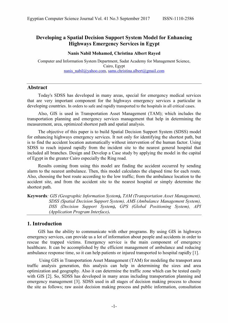
5. Proposed Spatial Decision Support System (SDSS) model for enhancing
highways emergency services
Develop SDSS model for enhancing highways emergency services in Egypt. The Steps
of building Spatial Decision Support System (SDSS) model as following:
First, automatically determining whether there is an accident or not without intervention
from any human factor by using sound sensors that measure the sound that was received,
cameras that capture a screenshot from accident site, and alarm that chooses the nearest
ambulance point. Second, find the shortest and the best path from the ambulance car location
to accident site and from the accident site to the suitable hospital. Third, calculating the
elapsed time to find the best route based on low traffic and time. Finally, reviewing a report
that includes Date/ Time of accident, hospital location, duration and destination.
- The sequence of this proposed model is as follows:
Collecting data about ambulance points (x, y) for each ambulance car, collecting data
about hospital points (x, y) for all branches of each general hospital that was included from
any governmental or public agency and using a web map from Google to add all these points on.
Then the model will start an analysis for the collected data using analysis tools like
SWOT, UML and Data Flow Diagram analysis tools. Based on the data that was collected
and analyzed, Determine places of cameras and sound sensors in columns traffic lights at each
one kilo meters in roads, all cameras and sensors will be connected to each other.
Then, the places and points of each general hospital will be sited on map. Also, the
points and places of each emergency ambulance car will be determined. This is one of the
Egyptian Computer Science Journal Vol. 41 No.3 September 2017 ISSN-1110-2586
-5-
main points of this thesis. The ambulance car must be provided with GPS. Then, make a simulation hardware that connects cameras and sensors with a web software application will be built.
According to those two parts (simulation Hardware and web application) the model will
find when an accident occurs. Sound sensors will detect sound intensity with high sensitivity
and measure the volume of sound from 1 to 5 degrees. So, if the sound reaches 5 degrees, the
camera will capture the accident and send alarm to the nearest ambulance that will receive a
screen shot from the accident that was happened.
So, the ambulance man can make the decision of whether to move to the accident site or
not after checking how fare the notification is real.
Then, if the ambulance driver is notified that there is an accident, using this model, to
calculate the elapsed time for each route and choose the best route that has low traffic from
the ambulance location to the accident site or simply determine the shortest path.
Then, this model will help in detecting the closest hospital also, based on calculating the
elapsed time for each route from the accident site to the hospital to reach the injured quickly.
Then, a report that will include date, time, accident site, hospital location, and duration will be
reviewed to the user.
And if the user checks the screen shot from the camera and does not find an accident
and it is just a sound the Ambulance driver will wait in his place until having another alarm as
shown in figure 1.
Figure 1: Proposed SDSS model for enhancing highways emergency services in Egypt.
Egyptian Computer Science Journal Vol. 41 No.3 September 2017 ISSN-1110-2586
-6-
6. Applying the Proposed SDSS model for enhancing highways emergency
services in Egypt
This case study was developed and designed in the following steps:
First Data Collection: collecting Data from many places to get information about
governmental hospitals, emergency ambulances and getting ring road map.
First get governmental hospitals information from "Central agency for public
mobilization and statistics".
Then, get emergency ambulances car position from "center for information and decision
support council of ministers in Egypt".
Finally, get ring road map from Google map.
Second Analysis: analyzing the system by using (SWOT analysis, UML, Use case,
Activity Diagram, Sequence Diagram, and Scenario Analysis", and Data Flow Diagram
"DFD0, DFD1") tools.
Finally, structure the Database using My SQL.
Third Designing the web Application: this step consists of two parts which are:
Simulation Hardware part and Software part Using GI[S and GPS.
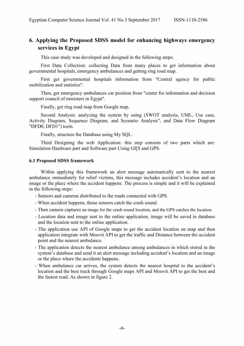
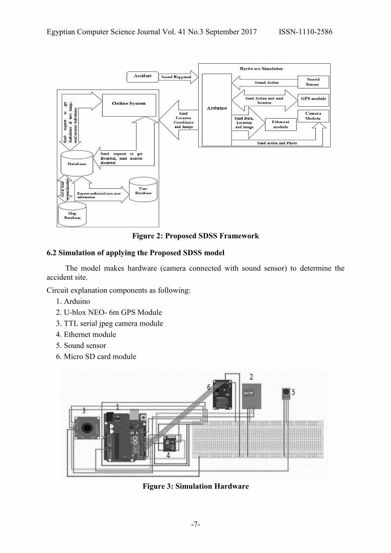
6.1 Proposed SDSS framework
Within applying this framework an alert message automatically sent to the nearest
ambulance immediately for relief victims, this message includes accident’s location and an
image or the place where the accident happens. The process is simple and it will be explained
in the following steps:
- Sensors and cameras distributed to the roads connected with GPS.
- When accident happens, those sensors catch the crash sound.
- Then camera captures an image for the crash sound location, and the GPS catches the location.
- Location data and image sent to the online application, image will be saved in database
and the location sent to the online application.
- The application use API of Google maps to get the accident location on map and then
application integrate with Moovit API to get the traffic and Distance between the accident
point and the nearest ambulance.
- The application detects the nearest ambulance among ambulances in which stored in the
system’s database and send it an alert message including accident’s location and an image
or the place where the accidents happens.
- When ambulance car arrives, the system detects the nearest hospital to the accident’s
location and the best track through Google maps API and Moovit API to get the best and
the fastest road. As shown in figure 2.
Egyptian Computer Science Journal Vol. 41 No.3 September 2017 ISSN-1110-2586
-7-
Figure 2: Proposed SDSS Framework
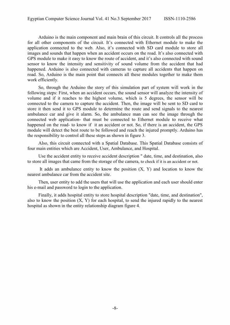
6.2 Simulation of applying the Proposed SDSS model
The model makes hardware (camera connected with sound sensor) to determine the
accident site.
Circuit explanation components as following:
1. Arduino
2. U-blox NEO- 6m GPS Module
3. TTL serial jpeg camera module
4. Ethernet module
5. Sound sensor
6. Micro SD card module
Figure 3: Simulation Hardware
Egyptian Computer Science Journal Vol. 41 No.3 September 2017 ISSN-1110-2586
-8-
Arduino is the main component and main brain of this circuit. It controls all the process
for all other components of the circuit. It’s connected with Ethernet module to make the
application connected to the web. Also, it’s connected with SD card module to store all
images and sounds that happen when an accident occurs on the road. It’s also connected with
GPS module to make it easy to know the route of accident, and it’s also connected with sound
sensor to know the intensity and sensitivity of sound volume from the accident that had
happened. Arduino is also connected with cameras to capture all accidents that happen on
road. So, Arduino is the main point that connects all these modules together to make them
work efficiently.
So, through the Arduino the story of this simulation part of system will work in the
following steps: First, when an accident occurs, the sound sensor will analyze the intensity of
volume and if it reaches to the highest volume, which is 5 degrees, the sensor will be
connected to the camera to capture the accident. Then, the image will be sent to SD card to
store it then send it to GPS module to determine the route and send signals to the nearest
ambulance car and give it alarm. So, the ambulance man can see the image through the
connected web application- that must be connected to Ethernet module to receive what
happened on the road- to know if it an accident or not. So, if there is an accident, the GPS
module will detect the best route to be followed and reach the injured promptly. Arduino has
the responsibility to control all these steps as shown in figure 3.
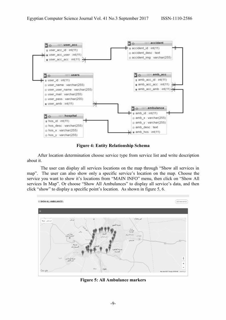
Also, this circuit connected with a Spatial Database. This Spatial Database consists of
four main entities which are Accident, User, Ambulance, and Hospital.
Use the accident entity to receive accident description " date, time, and destination, also
to store all images that came from the storage of the camera, to check if it is an accident or not.
It adds an ambulance entity to know the position (X, Y) and location to know the
nearest ambulance car from the accident site.
Then, user entity to add the users that will use the application and each user should enter
his e-mail and password to login to the application.
Finally, it adds hospital entity to store hospital description "date, time, and destination",
also to know the position (X, Y) for each hospital, to send the injured rapidly to the nearest
hospital as shown in the entity relationship diagram figure 4.
Egyptian Computer Science Journal Vol. 41 No.3 September 2017 ISSN-1110-2586
-9-
Figure 4: Entity Relationship Schema
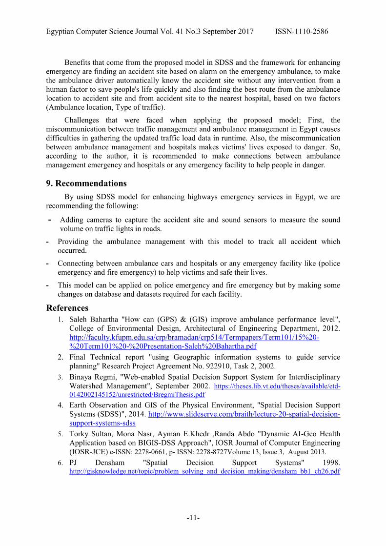
After location determination choose service type from service list and write description
about it.
The user can display all services locations on the map through “Show all services in
map”. The user can also show only a specific service’s location on the map. Choose the
service you want to show it’s locations from “MAIN INFO” menu, then click on “Show All
services In Map”. Or choose “Show All Ambulances” to display all service’s data, and then
click “show” to display a specific point’s location. As shown in figure 5, 6.
Figure 5: All Ambulance markers

Egyptian Computer Science Journal Vol. 41 No.3 September 2017 ISSN-1110-2586
-10-
Figure 6: All general Hospitals
When accident occurs, the user can show any accident that was done from "Show
Notification of accident".
7. Results
This paper presented a model in SDSS for enhancing emergency Roads in Egypt. This
model lets us use GIS in determining points (Latitude (X) and Longitude (Y)) of hospitals and
ambulances on map.
Another result is structuring a database using datasets for making an ambulance web
application that connects ambulance user, accident place and hospitals with each other.
Making a simulation part on this model, that is presented through using cameras,
sensors, and determining ambulance places on roads.
This model allows us to capture the accident and send alarm to the nearest ambulance
car in order to help the injured.
Also, this model allows us to use DSS in choosing the best route that has low traffic
from ambulance location to accident site and from accident site to hospital. Apply a case
study that fulfills all the requirements of the model.
By developing a Spatial Decision Support System Model, there are many results. First,
saving people's lives through helping the ambulance driver to know that there is an accident
automatically without intervention of the human factor. Second, sending alarm to the nearest
ambulance car to the accident site. Third, choose the best route from the nearest ambulance
location to the accident site. Fourth, choose the best route from the accident site to the nearest hospital.
8. Conclusion
This paper covers all the latest technologies and solutions for enhancing SDSS. Also,
SDSS used to identify steps for improving it in many fields, such as transportation planning,
emergency management. Also, SDSS can be used in solving problems and getting the best
solutions.
Egyptian Computer Science Journal Vol. 41 No.3 September 2017 ISSN-1110-2586
-11-
Benefits that come from the proposed model in SDSS and the framework for enhancing
emergency are finding an accident site based on alarm on the emergency ambulance, to make
the ambulance driver automatically know the accident site without any intervention from a
human factor to save people's life quickly and also finding the best route from the ambulance
location to accident site and from accident site to the nearest hospital, based on two factors
(Ambulance location, Type of traffic).
Challenges that were faced when applying the proposed model; First, the
miscommunication between traffic management and ambulance management in Egypt causes
difficulties in gathering the updated traffic load data in runtime. Also, the miscommunication
between ambulance management and hospitals makes victims' lives exposed to danger. So,
according to the author, it is recommended to make connections between ambulance
management emergency and hospitals or any emergency facility to help people in danger.
9. Recommendations
By using SDSS model for enhancing highways emergency services in Egypt, we are
recommending the following:
- Adding cameras to capture the accident site and sound sensors to measure the sound
volume on traffic lights in roads.
- Providing the ambulance management with this model to track all accident which
occurred.
- Connecting between ambulance cars and hospitals or any emergency facility like (police
emergency and fire emergency) to help victims and safe their lives.
- This model can be applied on police emergency and fire emergency but by making some
changes on database and datasets required for each facility.
References
1. Saleh Bahartha "How can (GPS) & (GIS) improve ambulance performance level",
College of Environmental Design, Architectural of Engineering Department, 2012.
http://faculty.kfupm.edu.sa/crp/bramadan/crp514/Termpapers/Term101/15%20-
%20Term101%20-%20Presentation-Saleh%20Bahartha.pdf
2. Final Technical report "using Geographic information systems to guide service
planning" Research Project Agreement No. 922910, Task 2, 2002.
3. Binaya Regmi, "Web-enabled Spatial Decision Support System for Interdisciplinary
Watershed Management", September 2002. https://theses.lib.vt.edu/theses/available/etd-
0142002145152/unrestricted/BregmiThesis.pdf
4. Earth Observation and GIS of the Physical Environment, "Spatial Decision Support
Systems (SDSS)", 2014. http://www.slideserve.com/braith/lecture-20-spatial-decision-
support-systems-sdss
5. Torky Sultan, Mona Nasr, Ayman E.Khedr ,Randa Abdo "Dynamic AI-Geo Health
Application based on BIGIS-DSS Approach", IOSR Journal of Computer Engineering
(IOSR-JCE) e-ISSN: 2278-0661, p- ISSN: 2278-8727Volume 13, Issue 3, August 2013.
6. PJ Densham "Spatial Decision Support Systems" 1998. http://gisknowledge.net/topic/problem_solving_and_decision_making/densham_bb1_ch26.pdf

Egyptian Computer Science Journal Vol. 41 No.3 September 2017 ISSN-1110-2586
-12-
7. Imtiyaz Pasha "Master Thesis in Geoinformatics (Ambulance management system
using GIS)" 2006.
8. Zakaria Robert Ngereja "towards a GIS-T database design and implementation for
public transit planning" march 2009. https://run.unl.pt/bitstream/
9. Cehi "Network analysis tools "GIS |||: GIS Analysis", 2011.
https://www.cdc.gov/dhdsp/maps/gisx/training/module3/files/2-module.pdf
10. Field Techniques manual "GIS, GPS & Remote sensing", 2012.
https://www.rgs.org/NR/rdonlyres/D5D046D8-5582-41D0-BEF8
D15A148C5D32/0/Chapter1GISGPSRemoteSensingandFieldwork.pdf
11. Piyushimita Thakuriah (Vonu), P.S. Sriraj, Paul Metaxatos, Inshu Minocha &
Tanushri Swarup, "Economic and Social Urban Indicators: A Spatial Decision Support
System for Chicago Area Transportation Planning", 2008.
http://utc.webhost.uic.edu/wp-content/uploads/SDSS-Rearch AAG2008_A-1.pdf
12. S.S. Keshkamat a,*, J.M. Looijen b, M.H.P. Zuidgeest a, "The formulation and evaluation
of transport route planning alternatives: a spatial decision support system for the Via
Baltica project, Poland", Journal of Transport GeographyVolume 17, Issue 1, 2008.
13. Lu´ıs Santos, Jo˜ao Coutinho-Rodrigues, Carlos Henggeler Antunes," A Web Spatial
Decision Support System for Vehicle Routing using Google Maps", Decision Support
Systems, Volume 51, Issue 1,3 November 2010.
14. Peter B. Keenan, " Spatial Decision Support Systems: A coming of age", Control and
Cybernetics vol. 35 No. 1, 2006.
15. Ric Skinner "The Evolving Role of GIS in Hospital & Healthcare Emergency
Management Emergency Management", Noveember 2010.
http://www1.udel.edu/DRC/emforum/recordings/20101117.pdf
16. Christopher T. Emrich, Susan L. Cutter, Paul J. Weschler," The saga Handbook of
GIS and Society" GIS and emergency management"", 17 October 2011.
http://www.saga-ereference.com/view/hdbk_GISsociety/n17.xml>
17. T J COVA, "GIS in emergency management", 2000.
http://www.geos.ed.ac.uk/~gisteac/gis_book_abridged/files/ch60.pdf
18. V.Bhanumurthy, Vinod M Bothale, Brajesh Kumar*, Neha Urkude, Reedhi Shukla,
"Route analysis for Decision support system in Emergency management through GIS
technologies", International Journal of Advanced Engineering and Global Technology
I Vol-03, Issue-02, February 2015.
19. Ashraf Gubara, Ali Amasha, Zakaria Ahmed, Shawki El ghazali, " Decision support
system network analysis for emergency applications", Informatics and Systems
(INFOS), International Conference, December 2014.
20. Lubna Yaqoob1, Naeem Ahmed Khan2, Fazli Subhan3," An overview of existing
decision support systems for disasters management", 2014.
http://www.academia.edu/12746034/AN_OVERVIEW_OF_EXISTING_DECISION_
SUPPORT_SYSTEMS_FOR_DISASTERS_MANAGEMENT
21. Michael Pidd, Richard Eglese, and Fnishakumari de silva, " CEMPS: A prototype
spatial decision support system to aid in planning emergency evacuations",
Transactions in GIS, vol. I, no. 4, p. 321, 1997.