Embed Size (px)
Citation preview

Masterthesis im Rahmen des
Universitätslehrganges „Geographical Information Science & Systems“
(UNIGIS MSc) am Zentrum für GeoInformatik (Z_GIS)
der Paris Lodron Universität Salzburg
zum Thema
Developing a Software-Architecture for Archaeological Raw-Dataoriginating from Excavations in Austria
vorgelegt von:
Mag. Thomas Winklehner
GIS 103467, UNIGIS MSc Jahrgang 2015
Zur Erlangung des Grades„Master of Science (Geographical Information Science & Systems) – MSc(GIS)“
Gutachter:Prof. Dr. Josef Strobl

I
ERKLÄRUNG DER EIGENSTÄNDIGEN ABFASSUNG DER ARBEIT
Ich versichere, diese Masterthesis ohne fremde Hilfe und ohne Verwendung anderer als der angeführten
Quellen angefertigt zu haben. Die Arbeit hat in gleicher oder ähnlicher Form noch keiner anderen
Prüfungsbehörde vorgelegen. Alle Ausführungen der Arbeit, die wörtlich oder sinngemäß übernommen
wurden, sind gekennzeichnet.
Hohenzell, am 28.Juli 2017

II
ACKNOWLEDGEMENTSFirst of all I would like to thank my parents for their support during all my academic studies as much as I want
to thank my good friend Mag. Johannes Reiter MSc for his counsel in technical terms. Not less do my thanks
go to the UNIGIS-Team and - in particular - to my supervisor Prof. Dr. Josef Strobl for making this work
possible and giving support in any imaginable way.
III
CONTENT
ACKNOWLEDGEMENTS IIABSTRACT - 1 -1. INTRODUCTION - 1 -
1.1. RESEARCH ENVIRONMENT - 1 -1.2. GENERAL OBJECTIVES - 3 -
1.2.1. Hypothesis and Proposition - 4 -1.2.2. General Requirements - 5 -1.2.3. Conceptual Solution - 6 -
2. IMPLEMENTATION: METHODS AND RESULTS - 9 -2.1. GENERAL REMARKS ON THE SOFTWARE DEVELOPMENT PROCESS - 9 -2.2. DATA-MODEL - 10 -
2.2.1. Scheme - 10 -2.2.2. Data-Model - 16 -2.2.3. Excursus: Ontologies - 18 -
2.3. GLOSSARIES - 19 -2.3.1. Scheme - 20 -
2.4. THE DESKTOP-APPLICATION - 21 -2.4.1. Programming Language and Framework - 21 -2.4.2. GUI-Overview and the Core Principle - 21 -2.4.3. External Dependencies - 23 -2.4.4. Main Internal Structure - 24 -
2.4.4.1. ThreadManager, Assignment and LockFreeQueue - 25 -2.4.4.2. Data-Structure/Data-Model Classes - 29 -2.4.4.3. SQLite and SpatiaLite - 30 -3.4.4.4. ConnectionUtility - 32 -
2.4.5. Functionality - 38 -2.4.5.1. Managing Data-Models - 40 -2.4.5.2. The current Data-Model - 41 -2.4.5.3. Handling Repositories - 42 -2.4.5.4. Inserting/Updating Data - 45 -2.4.5.5. Inserting/Updating Glossaries - 46 -2.4.5.6. QueryBuilder-Form - 46 -2.4.5.7. Query Results - 48 -2.4.5.8. Mapping - 49 -2.4.5.9. BLOBs - 52 -2.4.5.10. Long Term Assignments - 53 -2.4.5.11. Merging Repositories - 53 -2.4.5.12. External Indices - 53 -2.4.5.13. Helper-Tools - 54 -
2.4.6. Results - 56 -2.5. PUBLISHING THE DATA - 58 -
2.5.1. Server-Side-Scripting - 58 -2.5.2. The Server - 58 -
IV
2.5.3. Scripts and Documents - 59 -2.5.4. The Website - 60 -
2.5.4.1. Data-Model - 60 -2.5.4.2. The Query-Builder - 61 -2.5.4.3. Query-Results - 63 -2.5.4.4. 2D Mapping - 63 -2.5.4.5. 3D Visualization - 65 -
2.5.5. The WebFeatureService - 66 -2.5.6. Results - 71 -
2.5.6.1. Summary and Significance - 71 -2.5.6.2. Conclusion - 72 -
3. RESULTS - 74 -3.1. VERIFYING RESULTS - 74 -3.2. EXEMPLIFYING A PRACTICAL USE-CASE - 76 -
3.2.1. Employed Glossaries - 77 -3.2.2. Inserting Field Data - 78 -3.2.3. Data-Maintenance and -Handling - 79 -3.2.4. Data Archival - 81 -3.2.5. Publishing Data - 82 -
4. DISCUSSION - 87 -BIBLIOGRAPHY - 88 -APPENDIX - 93 -
DATA-MODEL - 93 -[DATASTRUCTURE].PHP - 126 -COLUMN.PHP - 130 -TABLE.PHP - 134 -GETDATASTRUCTFROMXML.PHP - 136 -MAINCONNECTIONUTILITY.PHP - 139 -MAINJSSCRIPT.JS - 141 -GETDOC.PHP - 162 -QUERY.PHP - 163 -GETFILE.PHP - 167 -
- 1 -
ABSTRACTSince the official Guidelines for Archaeological Measures in Austria [BDA] fail to provide an actual data-model applicable to databases and - by far parts - a binding terminology, archaeological records are giventhe chance to differ from each other in many structural and semantic ways thus hampering inter-project-data-compatibility. The variety in structure and semantics prevents data-integration and participation in ResearchInfrastructures, while, at the same time, the habit prevails not to grant other archaeologists access to thecollected data in a digital way at all. Thence, this paper illustrates the development of an exemplary software-architecture to overcome the unnecessary structural data-diversification and allow for collective (spatial)data-analysis across campaigns - an endeavour also based on the paradigm of open access to archaeologicaldata. The basic idea here is not to integrate data retroactively, but to accompany the life-cycle of the datawith suitable software-tools, in order to facilitate a certain data-structure and terminology for immediatedata-compatibility while simultaneously providing mechanisms for data-sharing and publishing. Theapproach is, by large parts, based on the conception that repetitive tasks recurring with each campaign arebetter left to automation instead of inventing the same solutions ever anew, so that it appears only reasonableto apply a collective data-model deployed in a bundle of applications. As a result, the effort of data-management will decrease, whereas - aside from various useful tools available by default since originatingfrom database-functions - subsequent data-processing in GeographicInformationSystems can resort to suitablyprepared data - without the archaeologist having to modify the excavation-process itself.
1. INTRODUCTION1.1. RESEARCH ENVIRONMENT
n order to shed light on the parameters,circumstances and challenges of this paper’stopic some recent proceedings on the field ofdigital-data-management, -sharing and -storing
in humanities and archaeology need to be mentioned:
Research Infrastructures
Although the practice of publishing research workvia print-media is still very much alive inarchaeology - given the fact, that archaeologicalresults tend to be rather long-lasting and somearchaeological papers rarely ever obsolescecompletely1 - the shortcomings of analogous mediaprovided nearly exclusively at specialised libraries orresearch facilities are hardly subject to debate thesedays any more. However, irrespective of theflourishing of e-journals and e-papers the mostrelevant trend related to open-access-data as well aslong-term-data-storing within recent years is the rise
1 One may consider papers presenting findings andarchaeological records resulting from excavation. This sort ofinformation never really becomes obsolete.
of so called Research Infrastructures. [See e.g.Richards 2012; Geser – Niccolucci 2013] Aspöck –Geser describe them as follows:
“Research infrastructures are facilities, resources andservices used by the scientific community to conductresearch. They include major research instruments,laboratories, databases, libraries and archivalcollections. Research infrastructures require digitalinfrastructure and services for information storage,management, processing, publication and access.”[Aspöck – Geser 2014]
Since 2002 the European Strategy Forum onResearch Infrastructures (ESFRI) has beenpromoting cooperation in policy-making on ResearchInfrastructures, in order to facilitate the so calledEuropean Research Area.2 [Aspöck – Geser 2014;ESFRI 03] ESFRI‘s aim is to overcomefragmentation of data and national policies, so as toprovide Europe’s researchers with up-to-dateResearch Infrastructures. [ESFRI 01; ESFRI 02;
2 For further information see for example: ERA, HERA,AVROSS, ERIC 01, ERIC 02 or ERIC 03.
I
- 2 -
ESFRI 03] As a result, several of the latter wereeither identified or sprung up newly created, as thereare in humanities DARIAH (Digital ResearchInfrastructure for the Arts and Humanities) and -more crucial in this context - ARIADNE (AdvancedResearch Infrastructure for Archaeological DatasetNetworking in Europe). [Aspöck – Geser 2014]Aside from not referring to archaeology in specific(at the moment) DARIAH-EU is still obviously inthe very act of being established,3 [DAHRIA-EU 01;DAHRIA-EU 02; ESFRI 03] while ARIADNE4 asvirtual e-infrastructure residing as (fourth) levelabove national/institutional infrastructures andintended to provide a common interface toarchaeological data dispersed over several data-providers [Richards 2012; Aspöck – Geser 2014;Geser – Niccolucci 2013] already offers (preliminary)papers on metadata-schemata, that are highly likelyto be supported in ARIADNE. Richards [2012]names several rather nationally initiatedinfrastructures5 intended to be associated under
3 DARIAH-DE, on the other side, does refer to data standards inarchaeology (see: https://wiki.de.dariah.eu/pages/viewpage.action?pageId=38080370#Empfehlungenf%C3%BCrForschungsdaten,ToolsundMetadateninderDARIAH-DEInfrastruktur-FachwissenschaftlicheMetadatenstandards%28Content%29 <lastvisited 15.01.2016>).Austria’s contribution is not specifically archaeological (see:http://www.clarin-dariah.at/de/node/11 <last visited 15.01.2016>and http://www.oeaw.ac.at/acdh/ <last visited 15.01.2016>).Parthenos, however, explicitly comprising archaeology is builtaround DARIAH (see: http://www.parthenos-project.eu <lastvisited 15.01.2016> and http://www.oeaw.ac.at/acdh/de/node/312 <last visited 15.01.2016>) and is itself settled in the WorkProgram Horizon 2020 [see: http://ec.europa.eu/programmes/horizon2020/en/what-horizon-2020 <last visited 15.01.2016>].4 “ARIADNE is an “Integrating Activity” project funded underthe Research Infrastructures strand of the European Union’sSeventh Framework Programme (FP7-Infrastructures-2012-1,contract no. 313193). The project started in February 2013 andwill run for four years. It involves 24 partners from 16 Europeancountries who develop a common data infrastructure and relatedtools, work on knowledge organisation and integration (e.g. useof CIDOC CRM, thesauri, linked data), involve otherstakeholders in Europe and beyond, and offer training, goodpractice guides, and access to their research facilities both on-siteand online […]. The overall goal of ARIADNE is to overcomethe fragmentation of archaeological data resources and to foster aresearch culture that values sharing and re-use of data, goingbeyond organisational and national boundaries. In archaeology,some national data centres, institutional repositories and variousother online resources already exist or are under development.”[Aspöck – Geser 2014]. Also see Niccolucci – Richards 2013.5 In order to enumerate some well known: Archaeology DataService [http://archaeologydataservice.ac.uk/ <last visited16.01.2016>], EDNA [http://www.dans.knaw.nl/en/content/categorieen/projecten/edna-e-depot-dutch-archaeology <last
ARIADNE whereas affirming the impression oflacking comparable archaeological e-infrastructuresin Austria.
Thus, any project dealing with data-management, -sharing or -storing in archaeology sure is welladvised to take Research Infrastructures into account.
Best Practice
Aside from (meta-) data-integration with ResearchInfrastructures archaeological data in Europe needsto fulfill certain requirements - nowadays also indigital terms -, in order to master the latest scientificstandards.6 First of all, in Austria there are thebinding, however in terms of data-structure and -semantics not very specific Guidelines forArchaeological Measures. [BDA] Fortunately and -with respect european-wide data-integration -beneficially, several projects and institutions alreadyworked out Guides for Good Practice inArchaeology and keep them up-to-date whileproviding them on the internet.7 Not quiteaccidentally it is usually in the course of setting upabove mentioned Research Infrastructures that theseguidelines emerge being source of relatively detailedreferences on how to best handle (digital)archaeological data. As a means to exert collectiveand qualified data-structure and -semantics across theprojects within the infrastructures to some degree, theguides can be an important repository of state-of-the-art qualities to anyone concerned with archaeology.
visited 16.01.2016>; Gilissen 2013], Swedish National DataService (SND) [http://snd.gu.se/en <last visited 16.01.2016>],The Strategic Environmental Archaeology Database (SEAD)[http://www.sead.se/ <last visited 16.01.2016>], IANUS[http://www.ianus-fdz.de/ <last visited 16.01.2016>], FASTIOnline [http://www.fastionline.org/index.php <last visited16.01.2016>]. Also see Niccolucci – Richards 2013.6 For a general overview see for example DFG 2013.7 Archaeology Data Service [http://guides.archaeologydataservice.ac.uk/ <last visited 16.01.2016>]; DARIAH-DE[Puhl 2015, https://wiki.de.dariah.eu/pages /viewpage.action?pageId =38080370 <last visited 16.01.2016> and https://wiki.de.dariah.eu/pages/viewpage.action?pageId=20058160 <last visited16.01.2016>]; IANUS [http://www.ianus-fdz.de/it-empfehlungen/]; ARIADNE provides references to examples ofgood practice [see Niven - Weight 2014)].CARARE is itself a Best Practice Network in order to makecontent compatible with EUROPEANA. [Richardson 2012].

- 3 -
Technologies
Since advances in the domain of (applied)informatics, respectively geoinformatics8, did notleave archaeology unaffected, several technologieshave had a deep impact on archaeological researchpractice and need to be mentioned in the context ofthis paper, as there are spatial-data-management, 3D-visualisation, WebGeographicInformationSystems andeXtensibleMarkupLanguage/GeographyMarkupLanguage. Whiletoday any task handling stochastic archaeologicaldata usually relies on data-management-tools likedatabases,9 the benefits of spatial-data-management-systems, respectively spatial databases, as thebackbone of spatially enabled applications havealready been recognized and exploited by a numberof projects,10 among which there are more than a fewarchaeological WebGIS-applications.11 The latter -involving traditionally 2D representations ofstructures and/or locations - have been developedinto 3D-enabled applications recently,12 in order tosuffice the purpose of visualising even above-groundruins and buildings. The function of archaeologicalWebGIS typically rests with simple localisation ofsites, display of excavation-findings, virtual-reconstructions or rendering the locations of culturalheritage.13 The data-management on the excavation-site, however, is commonly left to the responsibilityof the archaeologist in charge (albeit he can resort toa few ready-to-use software solutions)14.
8 see for example Brovelli – Magni 2003 or Scianna – Villa 2011.9 Observation of the author; also see Meyer and others [2006] fora little overview on the application of technologies inarchaeology until 2006.10 see for example Apollonio and others 2010.11 see for example Sebillo and others 2003; Semeraro 2007;Mantegari – De Salvo 2008; Cefalo and others 2011; Gallo –Roberto 2012; von Groote-Bidlingmaier and others 2015.12 see Richards-Rissetto and others 2010; De Luca and others2011; Billen and others 2013; Herban – Vilceanu 2013.13 Archaeological strata hardly ever appear to be subject to 3DWebGIS-mapping.14 The website http://www.bajr.org/bajrresources/software.asp<last visited 11.10.2015> lists all sorts of archaeologically usefulsoftware. On-site data-management applications can be found at:http://ark.lparchaeology.com/about/ <last visited 11.10.2015>,http://www.arctron.de/de/produkte/software/archaeodata/ <lastvisited 11.10.2015>, http://datalino.de/nerik/ <last visited11.10.2015>, https://www.esdm.co.uk/hbsmr-historic-environment <last visited 11.10.2015>, https://www.inari-software.com/?lang=de <last visited 11.10.2015>,http://www.iadb.org.uk/ <last visited 11.10.2015>,http://www.intrasis.com/engelska/index_eng.htm <last visited
Open Data
It is estimated that at the moment only 6 to 8% of allresearchers in archaeology give free access to theirdata, so that data-loss impends. [Aspöck – Geser2014] In this regard it is crucial to note that, althoughrescue-excavations oblige the causer to take financialresponsibility for the required archaeologicalmeasures [Denkmalschutzgesetz], the major financialmeans are supplied by public funds15, not to mentionthe public interest in cultural heritage. [see forexample Denkmalschutzgesetz]. So even though sitesof cultural heritage must be preserved and, thus, insome cases information about them kept secret,archaeological raw-data may be considered open datain a certain sense.16
1.2. GENERAL OBJECTIVESpon having given a rough summary onthe current situation of data-managementwithin Europe’s archaeology in thecourse of the previous chapter, important
effects of technologies and recent trends on thearchaeological research field were revealed havingapparently led towards a multitude of solutions, data-set-types [Costa a.o. 2014] and even languagesemployed [Niccolucci – Richards 2013].17 Isaksenand others [2009] put it the following way: “Whilstthe datasets all pertain to the same domain, theyfrequently employ mixed taxonomies and areheterogeneously structured…”, which is probablyrooted in archaeological vocabularies having a
11.10.2015>, http://www.amh.tg.ch/xml_74/internet/de/application/d813/f820.cfm <last visited 11.10.2015>,http://www.nabonidus.org/ <last visited 11.10.2015> andhttp://www.singularch.de/pocket_e.htm <last visited11.10.2015>.In order to give a rough overview of the explored softwaresolutions, several generally observed shortcomings need to beaddressed: The applications tend to be solely web-based, notreferring to metadata-standards, best-practice-guides orarchiving-friendly document-types and manage alphanumericand spatial data separately.15 see for example:https://wissenschaft.bmwfw.gv.at/bmwfw/forschung/national/forschungseinrichtungen/das-oesterreichische-archaeologische-institut-oeai/ <last visited 13.05.2017>.16 see https://www.data.gv.at/infos/zielsetzung-data-gv-at/ <lastvisited 13.05.2017> or http://www.inspire.gv.at/ <last visited13.05.2017>.17 National endeavours and approaches have hardly broughtbenefit in terms of comparability of data or knowledge on aeuropean level. [Niccolucci – Richards 2013].
U
- 4 -
tendency to be only maintained on an organizationallevel. [May and others 2011] So with Karagiannisand others [2012] it can be stated that“…multilingual knowledge representation, accessand translation are an impending need.”
On the other hand, future research is expected to betechnology- and big-data-driven [Riding the Wave2010; Geser – Niccolucci 2013; Aspöck – Geser2014] therefore transferring the more emphasis fromnational or institutional data-stores towardsinternational solutions. [Geser – Niccolucci 2013;Niccolucci – Richards 2013; also see: Riding theWave 2010 and Unsworth 2006] In order to meetthese issues and integrate all kinds of data frommiscellaneous sources properly, ResearchInfrastructures like ARIADNE are being establishedthough raising the question to what degree diversedata must and can be integrated at all. The currentpractice in cultural heritage and especially inARIADNE, thereby, is either to incorporateestablished metadata-standards or (- what appears tobe the prevailing habit -) map metadata according toan accepted pattern, more precisely in congruencywith an ontology providing semantics, for reusabilityof datasets needs to meet certain criteria in terms ofpurpose, exactness and reliability expressed bymetadata.18 [Geser – Niccolucci 2013; forARIADNE’s practice of mapping in accordance with
18 Although it is far beyond the scope of this paper to fullydiscuss the idea of the semantic web [see e.g. Berners-Lee andothers 2001], it is worth mentioning that its consequencesreached cultural history particularly in the form of ontologies (e.g.CHARM [www.charminfo.org <last visited 16.10.2015>; Costaand others 2014]), the most popular of which is CIDOC-CRM bynow established as ISO Standard (21127:2014)[http://www.cidoc-crm.org/ <last visited 16.10.2015>;http://www.iso.org/iso/catalogue_detail?csnumber=57832 <lastvisited 16.10.2015>]. While the most common ontology incultural heritage is CIDOC-CRM [see Doerr and others 2004;Szász and others 2006; Eide and others 2011; Karagiannis andothers 2012; Costa and others 2014], there are a number of(partly proprietary) elaborate metadata-standards like LIDO andEuropeana Data Model (EDM), both of which were heavilyinfluenced by CIDOC-CRM. [Geser – Niccolucci 2013 withoverview] LIDO and CIDOC-CRM are sure not satisfactory forarchaeological tasks, but they are flexible and extensible.[Geser – Niccolucci 2013] Two specialised archaeologicalextensions to CIDOC-CRM worth mentioning have also beenapplied in practice: 1. CIDOC-CRM-EH [see STELLAR; Mayand others 2011] 2. CRMarchaeo. Extensions, however, are onlyuseful when commonly agreed on and recognized.Also see Costa and others 2014 for a different attempt tointegrate archaeological metadata.
CIDOC-CRM see ARIADNE orhttp://139.91.183.82:8888/drupal/use-cases <lastvisited 16.10.2015>]
1.2.1. Hypothesis and Proposition
s far as in this very regard archaeologicalexcavation-data is concerned, the presentpaper intends to bring together the major
points19 discussed in the preceding chapters bypresenting the development process of a software-architecture as a means to accompany - in fact,facilitate - the full life-cycle of archaeological raw-data originating from excavation, so that eventuallyinter-campaign-compatible data meeting acceptedstandards is produced. Special interest rests, ofcourse, with the spatial aspect in all regards.
The idea behind this approach is that, whileaforementioned mapping-process usually integratesdiversely structured data of variant meaning on arather abstract semantic meta-level, Austria’sexcavation-data already is subject to regulation dueto national guidelines20 - one may nearly regard asfirst step towards a data-model - and could, therefore,be combined effortlessly on a national basis applyinga collaborative data-model and application. In orderto stress the normalised-, stochastic- and inventory-like-character of excavation records, it suffice toremark that the excavation process nowadays has ahabit of being outsourced to specialised, howevercommercial companies. As an archaeologist orexcavation-professional is primarily an expert in hisdomain, though, rather than an IT-specialist and doesnot need to be overly burdened with setting up data-management-tools for various campaigns ever anew -especially in the light of already existing guidelines -,this work aims for developing a comprehensiveapplication-architecture capable of employing suchdata-structure.21
19 …namely: ability for integration in Research Infrastructures,conformity with Austria’s guidelines on archaeological measures,guides on good practice, archivable datatypes, on-site data-management-tools and WebGIS.20 The core set of data-fields within excavation-datasets isgenerally heavily determined by national guidelines and usuallyresemble a kind of inventory. For Austria see BDA.21 “Automatic and easy to use tools are also necessary for themainstream uptake of the semantic web in the cultural heritagecommunity.” [Karagiannis and others 2012].
A
- 5 -
So in contrast to Research Infrastructures’ strategyto integrate existing cross-domain- and cross-origin-datasets retroactively the intention here - on the onehand - is to provide a software-tool, that not onlyenables the archaeologist to produce valid (spatial-)data in terms of structure and semanticscomprehensible in the sense of aforesaid guidelinesfrom the very beginning of an excavation-projectonward, but also preserves the full potential of datastructured uniformly across campaigns in accordancewith recognised standards22. On the other hand, thetool will manage to pool together different data-sets -as long as they adhere to the same data-model - andmake them accessible via website and WebFeatureService,so as to lend itself to a resource for ResearchInfrastructures. As a result, the produced recordsalso fit well in between the open data-sets (OpenGovernment Data)23 already provided by (federal)states in Europe,24 so that the local referenceframework for this paper’s case study shall beAustria.
1.2.2. General Requirements
s a means to elaborate the functional needsto be met by the software a task commonlyapplied is identifying use-cases, from which
requirements are deduced. [see UML Glasklar 2012]Since those very use-cases are later employed toevaluate this project’s yields, the correspondingillustrations can be found in chapter 3.1. VerifyingResults. What follows are several important issuesworth of closer discussion.
Data-Model
In the spirit of the foregoing paragraphs adumbratingthe need for a data-model this endeavour of software-
“Mapping requires skills and knowledge which are uncommonamong the cultural heritage professionals with the most thoroughknowledge of the material to be mapped. It is not only theabsence of facilitating tools, but also the existence of practices,legal obligations and the lack of a clear motivation that has as yetdelayed or reduced the creation of such mappings to a handfulcases.” [Eide and others 2011]22 In this context ‘standards’ refers mostly to geometry not beingpublished in proprietary, but in open format.23 The open datasets can in return be used in an application. ForOpen Data see, for example, https://www.land-oberoesterreich.gv.at/opendata.htm <last visited 18.10.2015>.24 Restricted access may be necessary due to protection ofcultural heritage.
development requires the elaboration of a data-model-scheme describing a valid model-structureaccepted by the software. The scheme as well as theresulting data-models must be readable, editable (incase of the models), ready for archiving and easilyexchangeable between systems and people. In casethe data-store is intended to be affiliated to aResearch Infrastructure, the models must also becapable of carrying an ontology’s entities andpredicates together with its model-items.
Glossaries / a-priory-Vocabularies
As soon as classifying is involved, the demand forstandardised descriptive terms arises leading towardsthis software’s requirement of supporting some kindof glossary. Because such a-priory-vocabularies maybe regarded as part of the data-model, they, too, aresubject to the same standards in terms of readability,editing, archiving and exchange.
Data
Although archaeological projects tend to utilisetechnologies, such as surveying-instruments, in orderto generate digital datasets directly, it is still mostlythe human expert creating and assembling data thusrepresenting the performance-bottleneck even forautomatically- or device-generated data being joinedwith manually recorded information anyway. Thence,the prevailing requirement here is the traditional andstill predominantly employed practice of humansinserting data into the digital medium. Beside thecommon data-management capacities specialemphasis must rest with handling geometries,durable storage of non-binary data as well as makingthe records accessible via approved and widelyaccepted gateways. Binary files, however, ofmiscellaneous size containing, for instance, photos or3D-models must be manageable together withalphanumeric data. Metadata is not a big concern inregard of the program itself, because it can always beprovided as a designated part of the data-model.
Assessment
In order to absolutely clarify the application’s task, itmust be stated that the main requirement is not todevelop a plugin, extension or converter to an
A
- 6 -
existing GeographyInformationSystem or database-system, butthe true backbone of excavations’ data-handling,which itself may in future be subject to extension.
Operating Systems
The gained knowledge and procedures of thisendeavour must be somewhat universally applicablein the regard that the software-architecture can beadapted to run on the three main operating systems ofpersonal computers. Additionally, referencedfunctions-libraries must not be proprietary, for theyshall be used freely. A desirable characteristic wouldalso be the software not requiring installation.
Special Conditions
As the planned software is supposed to be tailoredfor deployment in excavations, this venture not onlymust pay tribute to certain peculiarities of thearchaeological field of application, but can also takeadvantage of that circumstance. First of all,archaeological field studies are organised incampaigns and projects in such a way as to enabledata-handling to be grouped by those endeavours.When querying information, for example, only datafrom a certain campaign may be involved. Inaddition, once archaeological records are gathered,they rarely experience change as, for instance, awarehouse-inventory would do. On the other hand,during the recording process several people must beable to access and insert data simultaneously, while,at the same time, records may have to be transferred.Even though the internet can not be relied on asmedium for data-transfer in the project phase, theproject-staff usually works at the same locationanyway - thus facilitating networking via local files-exchange. Additionally, a simple backup-mechanismmight be beneficial. In general, simplicity inhandling is regarded a virtue given non-IT-specialist-archaeologists.
Scale
Even though several aspects on the issue of the long-term storage of digital data may be covered inassembling the software-architecture, that topic is notsupposed to be a central point, because the software’sdomain is intended to reach from single user to
project- or even inter-project-scale, however not tothe wide institutional level. While the resulting datais definitely aimed at contributing to big institutionaldata-stores, the software itself is not supposed tofulfill the job of a large-scale repository. Scalingefficiently within its field of application, though, is adesired effect.
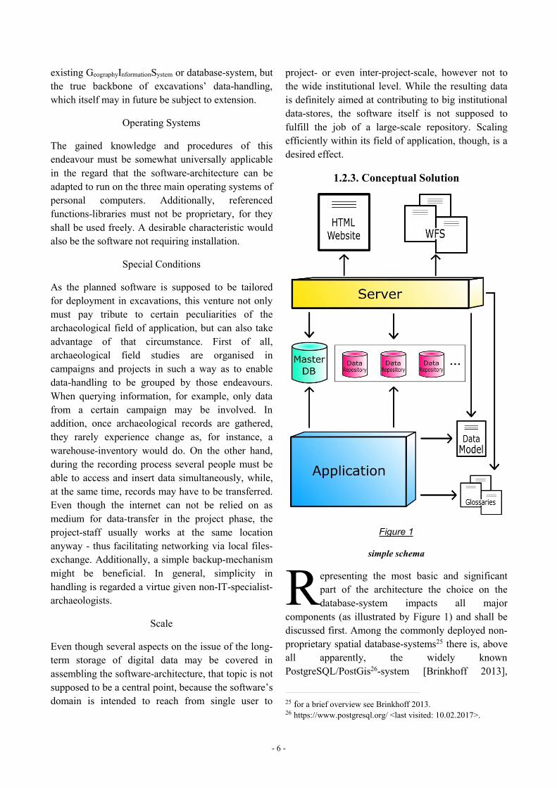
1.2.3. Conceptual Solution
Figure 1
simple schema
epresenting the most basic and significantpart of the architecture the choice on thedatabase-system impacts all major
components (as illustrated by Figure 1) and shall bediscussed first. Among the commonly deployed non-proprietary spatial database-systems25 there is, aboveall apparently, the widely knownPostgreSQL/PostGis26-system [Brinkhoff 2013],
25 for a brief overview see Brinkhoff 2013.26 https://www.postgresql.org/ <last visited: 10.02.2017>.
R
- 7 -
which unfortunately does not comply well with therequirements for file-based storage and portability, asit generally appears to be interlaced with the machineit runs on to non-negligible degree.27 Itscomparatively heavy footprint on the system - due toits amount of functions and storage-ability -, though,make it more of a candidate for institutional-leveldata-storage (and can still be integrated to theapplication in future endeavours). A suitable matchto the current requirements, however, is theSpatialLite-database-system28 with its strictly file-based-paradigm happily capable of being integratedwith mobile applications. [Brinkhoff 2013] Althoughlimited29 in storage-capacity compared to server-likesystems as aforementioned PostgreSQL/PostGis, itsknown limitations seem insignificant when storingcampaign-sized archaeological alphanumeric dataonly. Likewise, as outlined earlier data-entry issupposed to be accomplished by humans thusrestricting data-flux-density to a degree withinhuman scale. As the requirements-chapter indicated(see 1.2.2. General Requirements), binary data doesnot need to be stored in the database - given the fact,that typical database-tasks usually involvealphanumeric values and geometry -, but has to befound if needed. Besides, there might be a size-limitto so-called BLOB-fields in a database-system.
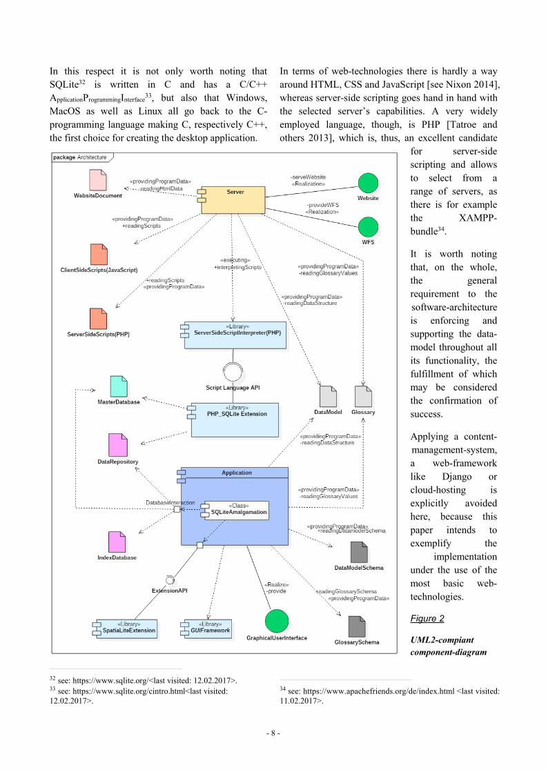
So in summary, the main characteristic of thearchitecture is its employment not of a singledatabase, but of a swarm of database-files eachrepresenting, for instance, an excavation-project,which pattern not only corresponds to the campaign-like archaeological field-research paradigm and therequirements outlined, but also brings certainchallenges to the application (together withadvantages to the undertaking as a whole). Asillustrated by Figure 1 and Figure 2 the mainexecutable component for the local user is a desktop-application residing above the database’sApplicationProgrammingInterface managing all data-handlingtasks. In order to work correctly, it accesses the data-model as well as the glossaries, which both have to
27 A portable, however still a little overly complicateddistribution is available at: https://sourceforge.net/projects/postgresqlportable/ <last visited: 10.02.2017>.28 https://www.sqlite.org/<last visited: 10.02.2017>; Owens 2006.29 https://www.sqlite.org/limits.html<last visited: 10.02.2017>.
be on hand as separate text-documents. A master-database is needed for permanent storage ofapplication-relevant information such as file-paths.The named documents as well as the master-databaseare also consulted by the server-component makingthe file-system the only connection between twoseparate applications: the desktop-program and theserver. The separation, thereby, prevents problems inapplying the architecture on different operatingsystems and makes the server-part an optional,exchangeable feature. The server - constituted by anexisting free-to-use software-solution - is entrustedwith publishing information about the data-model,the glossaries and the data itself on a website, so thata remote user gets an impression on what the data-store provides. The data itself shall be retrievable bythe user primarily via service, namelyWebFeatureService27, so that it can be requested inaccordance with a specified standard.
In regard of technologies applied and considering therequirement of portability the programming languageJava and its runtime-environment28 may seem areasonable foundation, as, on the one hand, thesource-code for the desktop-application remainsstatic irrespective of the operating system, on theother hand the popular server Apache Tomcat29 aswell as the WebMapService/WebFeatureService-server namedGeoserver30 rely on the same technology anyway.The dependency on a runtime-environment, however,is undesirable especially when applying a softwaresupposed to work without internet-connectivity, sothat technologies running natively on the operatingsystem are preferred.31
27 http://www.opengeospatial.org/standards/wfs<last visited:11.02.2017>; also see for example: Brinkhoff 2013 orTsalgatidou – Pilioura 2002.28 see: https://java.com/de/<last visited: 11.02.2017> orhttps://www.oracle.com/de/index.html<last visited: 11.02.2017>.29 see: http://tomcat.apache.org/<last visited: 11.02.2017>.30 see: http://geoserver.org/<last visited: 11.02.2017> orYoungblood 2013 and Henderson 2014.31 One may imagine a scenario, in which archaeologists aresupposed to be equipped with this software, but need to install aruntime-environment first. However, due to the remoteexcavation-site and the lack of internet-connectivity theendeavour fails.
- 8 -
In this respect it is not only worth noting thatSQLite32 is written in C and has a C/C++ApplicationProgrammingInterface33, but also that Windows,MacOS as well as Linux all go back to the C-programming language making C, respectively C++,the first choice for creating the desktop application.
32 see: https://www.sqlite.org/<last visited: 12.02.2017>.33 see: https://www.sqlite.org/cintro.html<last visited:12.02.2017>.
In terms of web-technologies there is hardly a wayaround HTML, CSS and JavaScript [see Nixon 2014],whereas server-side scripting goes hand in hand withthe selected server’s capabilities. A very widelyemployed language, though, is PHP [Tatroe andothers 2013], which is, thus, an excellent candidate
for server-sidescripting and allowsto select from arange of servers, asthere is for examplethe XAMPP-bundle34.
It is worth notingthat, on the whole,the generalrequirement to thesoftware-architectureis enforcing andsupporting the data-model throughout allits functionality, thefulfillment of whichmay be consideredthe confirmation ofsuccess.
Applying a content-management-system,a web-frameworklike Django orcloud-hosting isexplicitly avoidedhere, because thispaper intends toexemplify the
implementationunder the use of themost basic web-technologies.
Figure 2
UML2-compiantcomponent-diagram
34 see: https://www.apachefriends.org/de/index.html <last visited:11.02.2017>.
- 9 -
2. IMPLEMENTATION: METHODS AND RESULTShe following sub-chapters review thetechnical aspects of the software-architecture together with itsdevelopment process. As this is thevery core task of this endeavour
according to the definition given above (see 1.2.1.Hypothesis and Proposition), it is designated themost extensive treatise in this paper. The attentivereader may thereby notice the huge amount of effortneeded to run into setting up the applications’general business logic, before spatial functions canbe explicitly approached and implemented. In thisrespect, however, one must not forget that theoverall undertaking itself is - above all - motivatedby the goal of handling and finally publishing spatialdata.
Because the development is done on a windows 10operating system, all information given on theremaining sites is valid for exactly that system bydefault. Adaptations necessary for application ondifferent systems are hinted when required.
The sub-chapters, respectively sub-topics, areroughly sorted in an order representingdevelopment-steps from the most basic to the mostadvanced beginning with the data-model and thevocabularies, passing the desktop-application, inorder to finally treat of the server with its websiteand the WebFeatureService.
2.1. GENERAL REMARKS ON THE SOFTWARE
DEVELOPMENT PROCESShen considering softwaredevelopment the question soon arisesof which method, ‘school’ ortradition to follow. In reference to a
typical guide on that topic [see for example Dooley2011] there are a few important remarks to take, inorder to highlight the structure of this development-process:
First of all, the author of this text impersonating thesole developer is neither a professional programmernor had ever experienced the practical aspects oflarge-scale software-development before thebeginning of this endeavour hence making thatcircumstance part of the case-study while makingguidebooks - usually building up on some degree ofexperience - harder to apply.
The approach settled for, consequently, was toenforce a modular and strictly bottom-up strategy ofconsistently stacking higher-level components atoprather basic elements. Unlike an analytic top-downapproach the policy applied here does not seek toanticipate the full detailed application-architecturein advance - for that would presuppose a highamount of practical experience - , but is merelydriven by adding piece by piece towards an endpoint.Scheduling stopovers and setting intermediateobjectives was therefore rather motivated by astrategy than by a detailed preconceived road map.Besides, as one may conclude from Dooley [2011],the general vision of the finally functioningsoftware-structure is not infrequently put intopractice via more of an iterative gradual refinementas much as the resulting components, whetherstanding alone or having already been assembled,require careful testing thence dedicating anysoftware-composing-process to some kind ofrepetitive test-driven pattern.
So in order to roughly characterize thedevelopment’s actual proceedings the followingshall be stated: Components, modules, objects,functions etc. were created and tested as individualitems, if possible, before incorporated into thesoftware-structure, where in-context testinghappened. So until in the course of that process theapplications’ final state was reached, test-scenarioshad to be engineered.
T
W
- 10 -
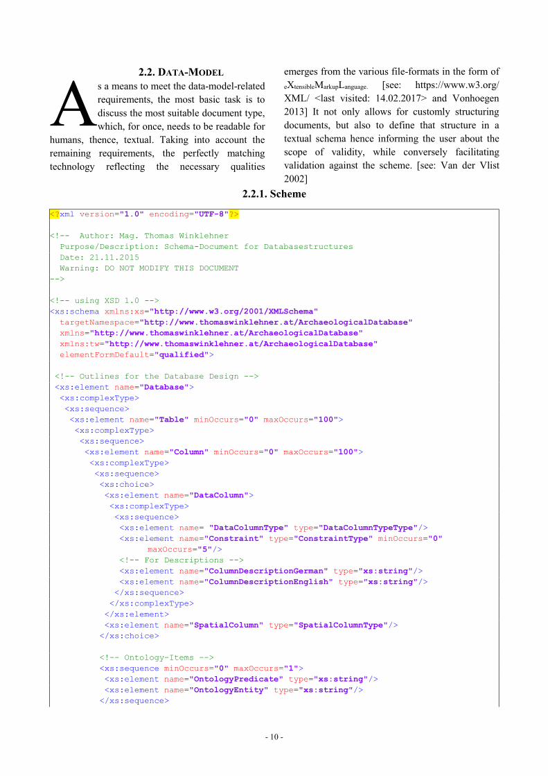
2.2. DATA-MODELs a means to meet the data-model-relatedrequirements, the most basic task is todiscuss the most suitable document type,which, for once, needs to be readable for
humans, thence, textual. Taking into account theremaining requirements, the perfectly matchingtechnology reflecting the necessary qualities
emerges from the various file-formats in the form ofeXtensibleMarkupLanguage. [see: https://www.w3.org/XML/ <last visited: 14.02.2017> and Vonhoegen2013] It not only allows for customly structuringdocuments, but also to define that structure in atextual schema hence informing the user about thescope of validity, while conversely facilitatingvalidation against the scheme. [see: Van der Vlist2002]
2.2.1. Scheme
<?xml version="1.0" encoding="UTF-8"?>
<!-- Author: Mag. Thomas WinklehnerPurpose/Description: Schema-Document for DatabasestructuresDate: 21.11.2015Warning: DO NOT MODIFY THIS DOCUMENT
-->
<!-- using XSD 1.0 --><xs:schema xmlns:xs="http://www.w3.org/2001/XMLSchema"targetNamespace="http://www.thomaswinklehner.at/ArchaeologicalDatabase"xmlns="http://www.thomaswinklehner.at/ArchaeologicalDatabase"xmlns:tw="http://www.thomaswinklehner.at/ArchaeologicalDatabase"elementFormDefault="qualified">
<!-- Outlines for the Database Design --><xs:element name="Database"><xs:complexType><xs:sequence><xs:element name="Table" minOccurs="0" maxOccurs="100"><xs:complexType><xs:sequence><xs:element name="Column" minOccurs="0" maxOccurs="100"><xs:complexType><xs:sequence><xs:choice><xs:element name="DataColumn"><xs:complexType><xs:sequence><xs:element name= "DataColumnType" type="DataColumnTypeType"/><xs:element name="Constraint" type="ConstraintType" minOccurs="0"
maxOccurs="5"/><!-- For Descriptions --><xs:element name="ColumnDescriptionGerman" type="xs:string"/><xs:element name="ColumnDescriptionEnglish" type="xs:string"/></xs:sequence></xs:complexType></xs:element><xs:element name="SpatialColumn" type="SpatialColumnType"/></xs:choice>
<!-- Ontology-Items --><xs:sequence minOccurs="0" maxOccurs="1"><xs:element name="OntologyPredicate" type="xs:string"/><xs:element name="OntologyEntity" type="xs:string"/></xs:sequence>
A
- 11 -
</xs:sequence>
<!-- Table Name needs to be repeated for referencing Foreign Key --><xs:attribute name="TableName" type="NameType" use="required"/><xs:attribute name="ColumnName" type="NameType" use="required"/></xs:complexType></xs:element>
<!-- For Descriptions --><xs:element name="TableDescriptionGerman" type="xs:string" minOccurs="1"
maxOccurs="1"/><xs:element name="TableDescriptionEnglish" type="xs:string" minOccurs="1"
maxOccurs="1"/>
<!-- Ontology-Items --><xs:choice minOccurs="0" maxOccurs="1"><xs:element name="OntologyPredicate" type="xs:string"/><xs:element name="OntologyEntity" type="xs:string"/></xs:choice>
</xs:sequence>
<xs:attribute name="TableName" type="NameType" use="required"/>
<!-- Purpose of the Table: for storing or providing Terms --><xs:attribute name="Use" use="required"><xs:simpleType><xs:restriction base="xs:string"><xs:enumeration value="Storage"/><xs:enumeration value="Vocabulary"/></xs:restriction></xs:simpleType></xs:attribute></xs:complexType>
<!-- Making Table-Name Reference for Use with the Columns of exactly that Table --><xs:key name="UniqueTableName"><xs:selector xpath="."/><xs:field xpath="@TableName"/></xs:key>
<!-- referencing Table-Name --><xs:keyref name="UniqueTableNameRef" refer="UniqueTableName"><xs:selector xpath="tw:Column"/><xs:field xpath="@TableName"/></xs:keyref>
<!-- Making ColumnName unique in the Scope of a Table --><xs:key name="Columns"><xs:selector xpath="tw:Column"/><xs:field xpath="@ColumnName"/></xs:key>
</xs:element>
<!-- Specify Indices --><xs:element name="Index" minOccurs="0" maxOccurs="unbounded"><xs:complexType>
- 12 -
<xs:attribute name="Name" type="NameType" use="required"/><xs:attribute name="Unique" type="xs:boolean" use="required"/><xs:attribute name="TableName" type="NameType" use="required"/><xs:attribute name="ColumnName" type="NameType" use="required"/></xs:complexType></xs:element>
</xs:sequence></xs:complexType>
<!-- Making Table-Name unique in the Scope of the Database--><xs:key name="UniqueTableNameInDataStructure"><xs:selector xpath="tw:Table"/><xs:field xpath="@TableName"/></xs:key>
<!--Making TableName and ColumnName unique and Key in the Scope of a Database--><xs:key name="PrimaryKey"><xs:selector xpath="tw:Table/tw:Column"/><xs:field xpath="@TableName"/><!--Tablename must be repeated for Foreign Key--><xs:field xpath="@ColumnName"/></xs:key>
<!-- Making Index-Table-Column-Pair unique in the Scope of a Database --><xs:key name="IndexTableColumnKey"><xs:selector xpath="tw:Index"/><xs:field xpath="@TableName"/><xs:field xpath="@ColumnName"/></xs:key>
<!-- Making IndexName unique in the Scope of a Database --><xs:key name="IndexNameKey"><xs:selector xpath="tw:Index"/><xs:field xpath="@Name"/></xs:key>
<!-- Referencing TableName and ColumnName to Indices --><xs:keyref name="IndicesTablesColumnsRef" refer="PrimaryKey"><xs:selector xpath="tw:Index"/><xs:field xpath="@TableName"/><xs:field xpath="@ColumnName"/></xs:keyref>
<!-- Referencing TableName and ColumnName to Foreign Key --><xs:keyref name="ForeignKeyRef" refer="PrimaryKey"><xs:selector xpath="tw:Table/tw:Column/tw:DataColumn/tw:Constraint/tw:FOREIGNKEY"/><xs:field xpath="@RefTableName"/><xs:field xpath="@RefColumnName"/></xs:keyref>
</xs:element>
<!--****************Column-Datatypes********************-->
<!-- DataColumnTypeType --><xs:complexType name="DataColumnTypeType"><xs:choice><xs:element name="NVARCHAR"><xs:complexType>
- 13 -
<xs:attribute name="Length" use="required"><xs:simpleType><xs:restriction base="xs:positiveInteger"><xs:pattern value="[0-9]{3}"/><xs:minInclusive value="2"/><xs:maxInclusive value="200"/></xs:restriction></xs:simpleType></xs:attribute></xs:complexType></xs:element>
<xs:element name="NUMERIC"><xs:complexType><xs:attribute name="Precision" use="required"><xs:simpleType><xs:restriction base="xs:positiveInteger"><xs:pattern value="[0-9]{2}"/><xs:minInclusive value="1"/><xs:maxInclusive value="20"/></xs:restriction></xs:simpleType></xs:attribute><xs:attribute name="Scale" use="required"><xs:simpleType><xs:restriction base="xs:nonNegativeInteger"><xs:pattern value="[0-9]{2}"/><xs:minInclusive value="0"/><xs:maxInclusive value="19"/></xs:restriction></xs:simpleType></xs:attribute></xs:complexType></xs:element>
<xs:element name="NCHAR"><xs:complexType><xs:attribute name="Length" use="required"><xs:simpleType><xs:restriction base="xs:positiveInteger"><xs:pattern value="[0-9]{3}"/><xs:minInclusive value="2"/><xs:maxInclusive value="100"/></xs:restriction></xs:simpleType></xs:attribute></xs:complexType></xs:element>
<xs:element name="OTHER"><xs:complexType><xs:attribute name="Type" type="OTHERType" use="required"/></xs:complexType></xs:element>
</xs:choice></xs:complexType>
<!-- Simple DataColumnTypeTypes -->

- 14 -
<xs:simpleType name="OTHERType"><xs:restriction base="xs:string"><xs:enumeration value="DATE"/><xs:enumeration value="TEXT"/><xs:enumeration value="BOOLEAN"/><xs:enumeration value="BLOB"/><xs:enumeration value="REAL"/><xs:enumeration value="INTEGER"/></xs:restriction></xs:simpleType>
<!-- SpatialColumnType --><xs:complexType name="SpatialColumnType"><xs:simpleContent><xs:extension base="GeometryName"><xs:attribute name="Dimension" type="GeometryDimension" use="required"/><xs:attribute name="Nullable" type="GeometryNullable" use="required"/></xs:extension></xs:simpleContent></xs:complexType>
<!-- Geometry Types --><xs:simpleType name="GeometryName"><xs:restriction base="xs:string"><xs:enumeration value="POINT"/><xs:enumeration value="LINESTRING"/><xs:enumeration value="POLYGON"/><xs:enumeration value="MULTIPOINT"/><xs:enumeration value="MULTILINESTRING"/><xs:enumeration value="MULTIPOLYGON"/></xs:restriction></xs:simpleType>
<!-- Geometric Dimensions --><xs:simpleType name="GeometryDimension"><xs:restriction base="xs:string"><xs:enumeration value="XY"/><xs:enumeration value="XYZ"/><xs:enumeration value="XYM"/><xs:enumeration value="XYZM"/></xs:restriction></xs:simpleType>
<!-- Geometry Nullable --><xs:simpleType name="GeometryNullable"><xs:restriction base="xs:nonNegativeInteger"><xs:pattern value="[0-1]"/><xs:minInclusive value="0"/> <!-- Geometry Nullable --><xs:maxInclusive value="1"/> <!-- Geometry not Nullable --></xs:restriction></xs:simpleType>
<!--******************Constraint-Datatypes*******************-->
<xs:complexType name="ConstraintType"><xs:choice><xs:element name="SimpleConstraint"><xs:complexType><xs:simpleContent> <!-- Containing CHECK-Statement, if one exists -->
- 15 -
<xs:extension base="xs:token"><xs:attribute name="Type" type="SimpleConstraintType" use="required"/></xs:extension></xs:simpleContent></xs:complexType></xs:element><xs:element name="FOREIGNKEY"><xs:complexType><xs:attribute name="RefTableName" type="NameType" use="required"/><xs:attribute name="RefColumnName" type ="NameType" use="required"/><xs:attribute name="DeleteAction" type="ForeignKeyActionType" use="required"/><xs:attribute name="UpdateAction" type="ForeignKeyActionType" use="required"/></xs:complexType></xs:element></xs:choice></xs:complexType>
<xs:simpleType name="SimpleConstraintType"><xs:restriction base="xs:string"><xs:enumeration value="UNIQUE"/><xs:enumeration value="PRIMARY KEY"/><xs:enumeration value="NOT NULL"/></xs:restriction></xs:simpleType>
<xs:simpleType name="ForeignKeyActionType"><xs:restriction base="xs:string"><xs:enumeration value="NO ACTION"/><xs:enumeration value="RESTRICT"/><xs:enumeration value="SET NULL"/><xs:enumeration value="CASCADE"/></xs:restriction></xs:simpleType>
<!--******************Global-Datatypes*******************-->
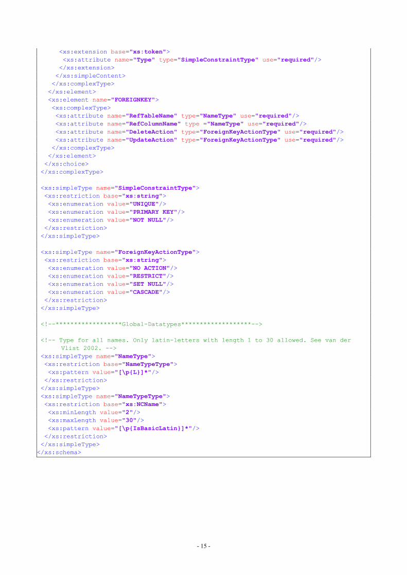
<!-- Type for all names. Only latin-letters with length 1 to 30 allowed. See van derVlist 2002. -->
<xs:simpleType name="NameType"><xs:restriction base="NameTypeType"><xs:pattern value="[\p{L}]*"/></xs:restriction></xs:simpleType><xs:simpleType name="NameTypeType"><xs:restriction base="xs:NCName"><xs:minLength value="2"/><xs:maxLength value="30"/><xs:pattern value="[\p{IsBasicLatin}]*"/></xs:restriction></xs:simpleType></xs:schema>
- 16 -
lthough the scheme’s structure is intendedto be self-explanatory for those familiarwith eXtensibleMarkupLanguage, several content-
related project-specific aspects deserve mention:
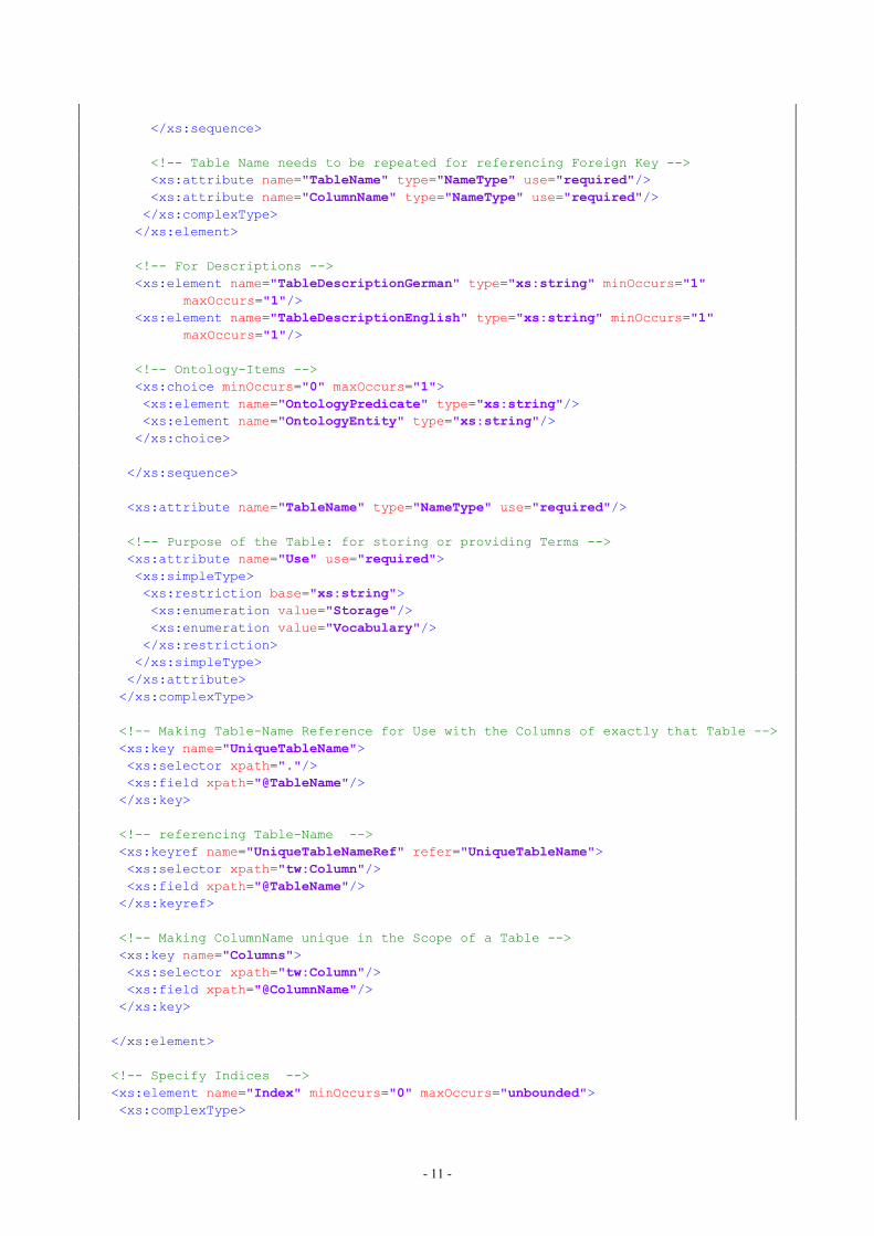
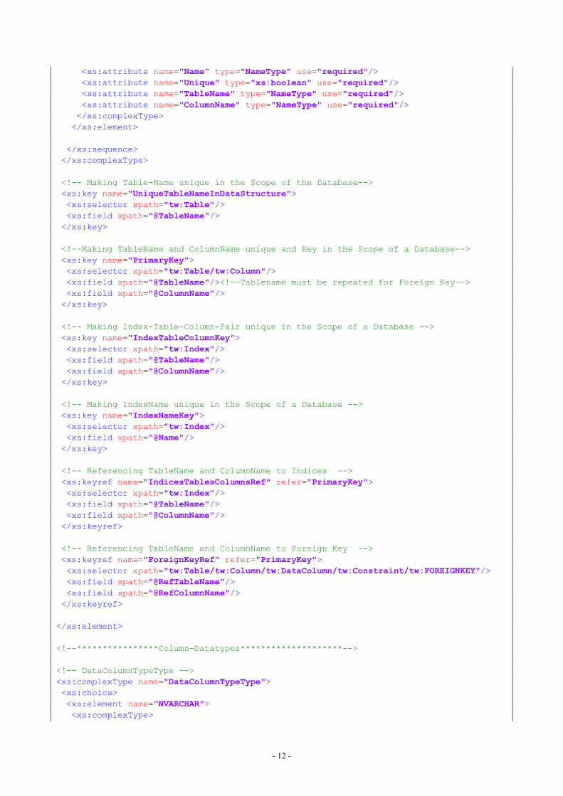
The actual data-fields the schema describesresemble tables, columns and indices in a database-structure and contain, therefore, all the informationnecessary to build up that structure in a database-system.
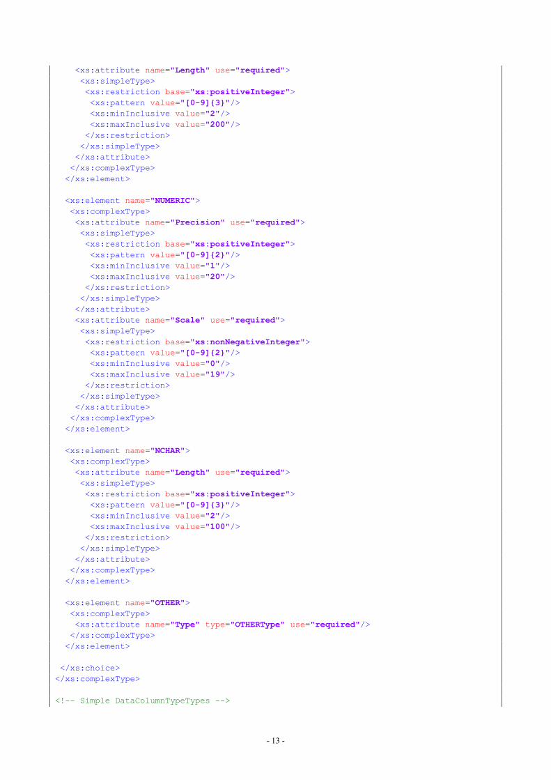
The distinction between two different table-typestakes account of the fact that a table containing aglossary is subject to different rules than a table foractual data-storage (see 2.3.1. Scheme). The scheme,then, makes use of X-Path35 elements, in order to notonly enforce unique table- and column-names, butalso to allow for referencing those names in relationwith database-foreignkeys. The intention, therefore,is to incorporate into the scheme as much validity-checking as possible, which also holds true fordefining data- or column-types quite strictly. Thelatter are construed from SQLite36/SpatiaLite37 fieldtypes, but do not cover the entire spectrum ofavailable options or functions38. Since being themajor concern in this endeavour the support ofSpatiaLite’s geometry-types, build up the core issue.Additionally, the number of tables as well ascolumns per table is restricted to a reasonable degree.
Additionally entities and predicates of an ontologycan be included, so as to allow for the schema’selements to be mapped to another model. Theschema allows for ontology-entities to be assignedto tables and columns, whereby foreign-key-columns stand for the referenced table. Relations areexpressed as predicates mostly assigned to columns,so that they are to be understood as a constellationof ‘table-entity - column-predicate - column-entity’thereby forming a sort of sentence. In rare cases atable may carry a predicate instead of an entity,when its only purpose is representing a connection
35 see: https://www.w3.org/TR/xpath/ <last visited: 14.02.2017>and Vonhoegen 2013.36 see: https://www.sqlite.org/datatype3.html <last visited:14.02.2017> and Owens 2006.37 see: http://www.gaia-gis.it/gaia-sins/spatialite-manual-2.3.1.html <last visited: 14.02.2017>.38 Consider for example AUTOINCREMENT or default-valuesfor columns.
between two other tables in the manner of a many-to-many multiplicity.
The following chapter discussing the data-modelactually applied in this project exemplifies the waythe scheme can be implemented - thence illustratingthe scheme’s purpose.
2.2.2. Data-Model
ortunately, the Guidelines for ArchaeologicalMeasures in Austria [BDA] equip thisendeavour with a pool of data fields, most of
which were directly incorporated into the model.
It deems reasonable to be geared by the formsprovided by aforesaid guidelines, as they are notonly published by the national agency for culturalheritage, but provide also the legal framework forarchaeological measures in Austria and must, hence,be widely recognized.
In database-design several conceptual guidelineshave been established as a means to lead towardsconsistent database-drafts. The chosen illustration(see Figure 3), for instance, widely followsconventions of entity-relationship-modelling. [seeBarker 1999; Kleuker 2011] Aside from sheergraphical issues some core paradigms qualifysophisticated database-designs, as there are non-redundant data-storage, integrity as well ascoordinating data-access and rights. [Kleuker 2011]While there are complete process models, that canbe employed from scratch to ready database-model,the first steps in that procedure are jumped here, asthe mentioned Guidelines for ArchaeologicalMeasures in Austria already bring an ordered set ofentities and attributes. From basic entity-relationship-diagrams table-structures are usuallydeduced applying the well-established levels ofnormalization [see Kleuker 2011] consequentlyleading towards the database design displayed inFigure 3.
A
F
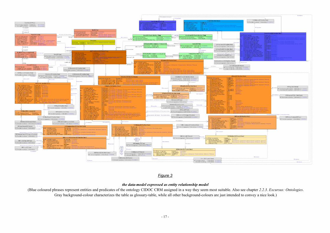
- 17 -
Figure 3
the data-model expressed as entity relationship model(Blue coloured phrases represent entities and predicates of the ontology CIDOC CRM assigned in a way they seem most suitable. Also see chapter 2.2.3. Excursus: Ontologies.
Gray background-colour characterizes the table as glossary-table, while all other background-colours are just intended to convey a nice look.)
- 18 -
Deviations from the Guidelines
Geometries are, as a matter of course, directly storedin the database constituting the core advantage overthe classic recording practice. All terms are inEnglish, so as to promote unhindered access andunderstanding, since like said in the introductorychapter european-wide integration is definitely adesideratum. Hence, the challenge arises to employsuitable terms. Regarding human remains and burialpractice the guidelines present several comments ontomb arrangements and fittings, that are bettertreated as features of their own (indicated on theaccompanying forms anyway). Finds, on the otherhand, are only concerned by the guidelines’ forms incontext with burials, so that the data model employsa separate finds-section providing - fordemonstrating purposes only - tables for ceramicvessels. That section relates to the table of‘UnitOfStratification’, in order to connect finds withtheir stratigraphic contexts (and not just withburials). Since omitted in the guidelines, thestructure of the finds’ tables are the authors productand supposed to be extended for various kinds offinds in the practical use. The very unspecific fieldsfor dating must be considered a shortcoming of theguidelines’ specifications, as there has to be a cleardifference between dating the creation of a unit ofstratification (e.g. constructing a building dated bymarks) and the dating of the period of its use. Hence,there is also a clear semantic difference in terms ofdating between different kinds of units ofstratification, considering, for example, sediment,the deposition of which being the only dateablefactor about it. In a similar manner other fields wereadded to the data model, where it appearedreasonable. Conversely, composition and additivesof masonry-binding are combined into one field.The guidelines’ forms for geodetic survey are leftaside, because their information is not actuallyrelevant for archaeological research. The same holdstrue for addresses of people involved. Multiple-choice-fields as well as those requiring a certainvocabulary representing a list of valid values areimplemented as separate glossary-tables.
Entities and predicates of the ontology namedCIDOC-CRM (see 2.2.3. Excursus: Ontologies)were mapped to the corresponding model-items.
2.2.3. Excursus: Ontologies
hen it comes to the main concern of thispaper - namely integration andcomparability of excavations’ raw data -,
the generated data-model cannot ignore commonontologies, the widest employed of which in culturalheritage clearly being CIDOC-CRM39, an approvedstandard - as pointed out in the introductory chapter- equipped with the ability to name spatial entities.The conceptual reference model CIDOC-CRM,thereby, provides the common ground for unequallystructured databases holding comparable contentsupposed to be integrated. The integration-processitself relies on mapping the specific model-items tothe abstract ontology.
The benefit of the conceptual reference model restswith its inherent semantics exploiting resourcedescription framework’s40 syntax together withprinciples of ‘subject’, ‘predicate’ and ‘object’.Thanks to its abstractness it can unambiguouslyreside on top of the designed database schemeattaching its own abstract semantic entities to tablesand columns whilst conferring additionalimplication and scope to the records. Not only canthe data-model, thus, be easier joined with akincultural-heritage-data - as it has already beenmapped to CIDOC-CRM (a task practised also atResearch Infrastructure ARIADNE) –, but the datamodel itself becomes more consistent having had tofit itself in with an approved ontology.
Efforts have already been made to develop specialontologies for archaeological excavation data, whichat first glance appears beneficial. But before two ofthem are discussed closer, the very profoundintention of ontologies has to be considered, namely
39 Current version can be found at:http://83.212.168.219/CIDOC-CRM/Version/version-6.2 <lastvisited 14.11.2015>; http://83.212.168.219/ CIDOC-CRM/sites/default/files/cidoc_crm_version _6.2.pdf <lastvisited 14.11.2015>.For information on the model see: http://www.cidoc-crm.org/<last visited 14.11.2015>.40 see e.g. http://www.w3.org/RDF/ <last visited 20.11.2015>.
W
- 19 -
to integrate data across disciplines. Taking awayabstractness by tailoring the ontology to a morespecific domain means annihilating most of its corequality and degrading it almost to a simple datamodel.
This said, the CRM-EH developed by EnglishHeritage deserves a note, as it maps archaeologicalprocesses and concepts of English Heritage toCIDOC-CRM.41 Entities of the latter are, thereby,endowed with excavation-specific meaning, yet aslong as the excavation-process is not sought to beconducted in the way of English Heritage, theCRM-EH - as not constituting an ontology by itself -hardly contributes to the data-model in thisendeavour.
On the other hand, there is CIDOC-CRMarchaeo42,a kind of refinement of the regular CIDOC-CRM inarchaeological terms. This alleged enhancementintroduces archaeological subclasses (to the regularclasses), while at the same time mixing up not onlydifferent levels of abstractness, but also general withdomain-specific classes - raising therewith thehazard of class-conflicts. Another critical point isthe fact that the archaeological entities inherit fromentity E53 Place (probably in order to make itspredicates available) - a condition avoided in theregular conceptual reference model, where place isnearly always just a quality to events or things.Allowing archaeological entities to be descendantsof E53 Place implies that a unit of stratification hasa location and is a location at the same time,whereas its identity is apparently directly related tothe location.
The conclusion drawn from the discussion above isthat among aforesaid ontologies only CIDOC-CRMin its regular form (which was made into a standard)can be applied fruitfully, so as to contribute to thedesign of the data model. In that way the ontology
41 see: http://hypermedia.research.southwales.ac.uk/resources/crm/ <last visited 14.11.2015> and: http://hypermedia.research.southwales.ac.uk/media/files/documents/2010-05-05/Arch_Ontological_ModellingV4.pdf <last visited14.11.2015>.42 see: http://www.ics.forth.gr/index_main.php?l=e&searchtype=st_p&c=711&i= <last visited 14.11.2015> andhttp://www.cidoc-crm.org/docs/cidoc_crm_sig/CRMarchaeo_v1.3.pdf <last visited 14.11.2015>.
bridges the semantic-gap between disciplines,whereas intending to integrate data exclusivelywithin the domain of archaeological excavation anapproach of either providing a truly specified andconclusive ontology or a data model should be taken.The latter is sought for by this paper.
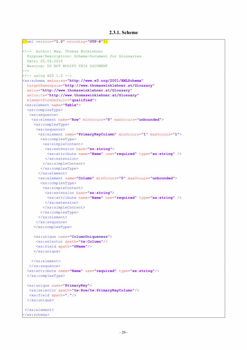
2.3. GLOSSARIEShere the Guidelines for ArchaeologicalMeasures in Austria do not provide theterminology to fill the (multiple-choice-)
fields with and a systematic nomenclature is clearlydesired, vocabularies are sought to be employed, soas to purvey documented and recognisedterminologies. Since glossaries are subject to similarrequirements as the data-model, the sametechnology for encoding is applied, namelyeXtensibleMarkupLanguage (see 2.2. Data-Model), in orderto structure glossary-documents. The followingscheme, therefore, describes the valid compositionof such documents, so that a measure ofstandardisation is provided. The schema defines‘Table’ as root-element and a sequence of rows asits child-elements, whereupon a ‘Row’ is made upof exactly one ‘PrimaryKeyColumn’-element andzero or more ‘Column’-elements. The table as wellas each of the columns possess an attribute called‘Name’ making a valid glossary-document reflectrows and columns in a table. Although notillustrated by the scheme, there are certainconceptual limitations to glossaries, as there are:
While in a database a table may feature compositeprimary-keys, that concept hardly deems reasonablefor a glossary, as the term the glossary is supposedto provide takes that part. Likewise, all columnsmust only contain alphanumeric values by reasonthat the glossary-terms will be engaged as foreign-keys within another table, whereas the remainingcolumns are solely meant to describe the terms inmore detail. Binary data, for instance, would have tobe encoded in hexadecimal notation, in order to bestored in XML-documents, and would, therefore,extend the documents unnecessarily. Additionally,glossaries are not expected to employ foreign-keysthemselves, as they only provide vocabulary. Theyare ending points, respectively top-elements, withinany data-model.
W
- 20 -
2.3.1. Scheme
<?xml version="1.0" encoding="UTF-8"?>
<!-- Author: Mag. Thomas WinklehnerPurpose/Description: Schema-Document for GlossariesDate: 25.04.2016Warning: DO NOT MODIFY THIS DOCUMENT
--><!-- using XSD 1.0 --><xs:schema xmlns:xs="http://www.w3.org/2001/XMLSchema"targetNamespace="http://www.thomaswinklehner.at/Glossary"xmlns="http://www.thomaswinklehner.at/Glossary"xmlns:tw="http://www.thomaswinklehner.at/Glossary"elementFormDefault="qualified"><xs:element name="Table"><xs:complexType><xs:sequence><xs:element name="Row" minOccurs="0" maxOccurs="unbounded"><xs:complexType><xs:sequence><xs:element name="PrimaryKeyColumn" minOccurs="1" maxOccurs="1"><xs:complexType><xs:simpleContent><xs:extension base="xs:string"><xs:attribute name="Name" use="required" type="xs:string" /></xs:extension></xs:simpleContent></xs:complexType></xs:element><xs:element name="Column" minOccurs="0" maxOccurs="unbounded"><xs:complexType><xs:simpleContent><xs:extension base="xs:string"><xs:attribute name="Name" use="required" type="xs:string" /></xs:extension></xs:simpleContent></xs:complexType></xs:element></xs:sequence></xs:complexType>
<xs:unique name="ColumnUniqueness"><xs:selector xpath="tw:Column"/><xs:field xpath="@Name"/></xs:unique>
</xs:element></xs:sequence><xs:attribute name="Name" use="required" type="xs:string"/></xs:complexType>
<xs:unique name="PrimaryKey"><xs:selector xpath="tw:Row/tw:PrimaryKeyColumn"/><xs:field xpath="."/></xs:unique>
</xs:element></xs:schema>
- 21 -
2.4. THE DESKTOP-APPLICATIONs with creating the data-model the firstconcern of assembling the desktop-application is rooted in settling for asuitable technology to employ - as
exemplified by the subsequent section.
2.4.1. Programming Language andFramework
n order not to repeat the reasons presentedabove (chapter 1.2.3. Conceptual Solution) infavour of C/C++ as the most suitable
programming language for this project, only thefollowing quotation shall be cited, so as to stand fora brief paraphrase on the language:
“C++ is an object-oriented, low-level ANSI and ISOstandard programming language. As a low-levellanguage similar to and compatible with itspredecessor C, C++ can generate very efficient, veryfast programs. As an object-oriented language, C++has the power and extensibility to write large-scaleprograms. C++ is one of the most popularprogramming languages for all types of programs.Most of the programs you use on your PC every dayare written in C++. C++ has been certified as a 99.9percent pure standard. This makes it a portablelanguage. There is a C++ compiler for every majoroperating system, and they all support the same C++language. (Some operating systems supportextensions to the basic language, but all support theC++ core.)”[Davis 2004]43
Having determined the preferred programminglanguage the next methodological building blocktowards setting up the desktop-application is findinga framework for the GraphicalUserInterface. As to notbeing forced to produce several source-codepackages - one per operating system (OS) andcompiler -, a framework named Qt44 will bereferenced in this endeavour.
“Qt is a comprehensive C++ framework fordeveloping cross-platform GUI applications using a‘write once, compile anywhere’ approach. Qt lets
43 For more information on the topic see: Deitel – Deitel 2012,Horton 2014, Josuttis 2012 or Stroustrup 2013.44 see: https://www.qt.io/ <last visited: 15.02.2017>.
programmers use a single source tree forapplications that will run on Windows [...], MacOSX, Linux, Solaris, HP-UX, and many otherversions of Unix with X11. The Qt libraries andtools are also part of Qtopia Core, a product thatprovides its own window system on top ofembedded Linux.” [Blanchette –Summerfield 2006]
A useful feature of Qt not mentioned yet is itssignal-slot-mechanism, in order to trigger functionson certain events.45 Qt comes with diverse licensingoptions [https://www.qt.io/download/ <last visited:15.02.2017>], one of which is the so called GNULesser General Public License (LGPL), that can beemployed without charge under certain obligations.[https://www.qt.io/qt-licensing-terms/ <last visited:15.02.2017>; https://www.qt.io/faq/#_Toc_3_7<last visited: 15.02.2017>] Although the latter areneglected in the course of this paper, as the resultingsoftware is neither commercially sold nor publishedin any way, LGPL stands for the option aspired for -accordingly bringing about the duty of dynamicallybinding the desktop application to the Qt-libraries -a relevant procedure in terms of licensing46. A toolcommonly supplied with the Qt-packages is QtCreator47, an IntegratedDevelopmentEnvironment, that bydefault has dynamic linking enabled and was notonly by that reason used for this project. There is, ofcourse, a documentation on Qt’s capabilities48accessible online, with regard of which one maybear in mind Qt 5.7 being the current version duringthis application’s development phase.
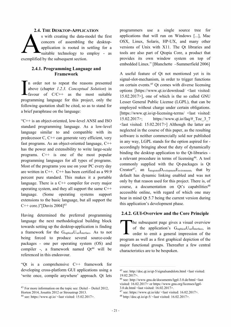
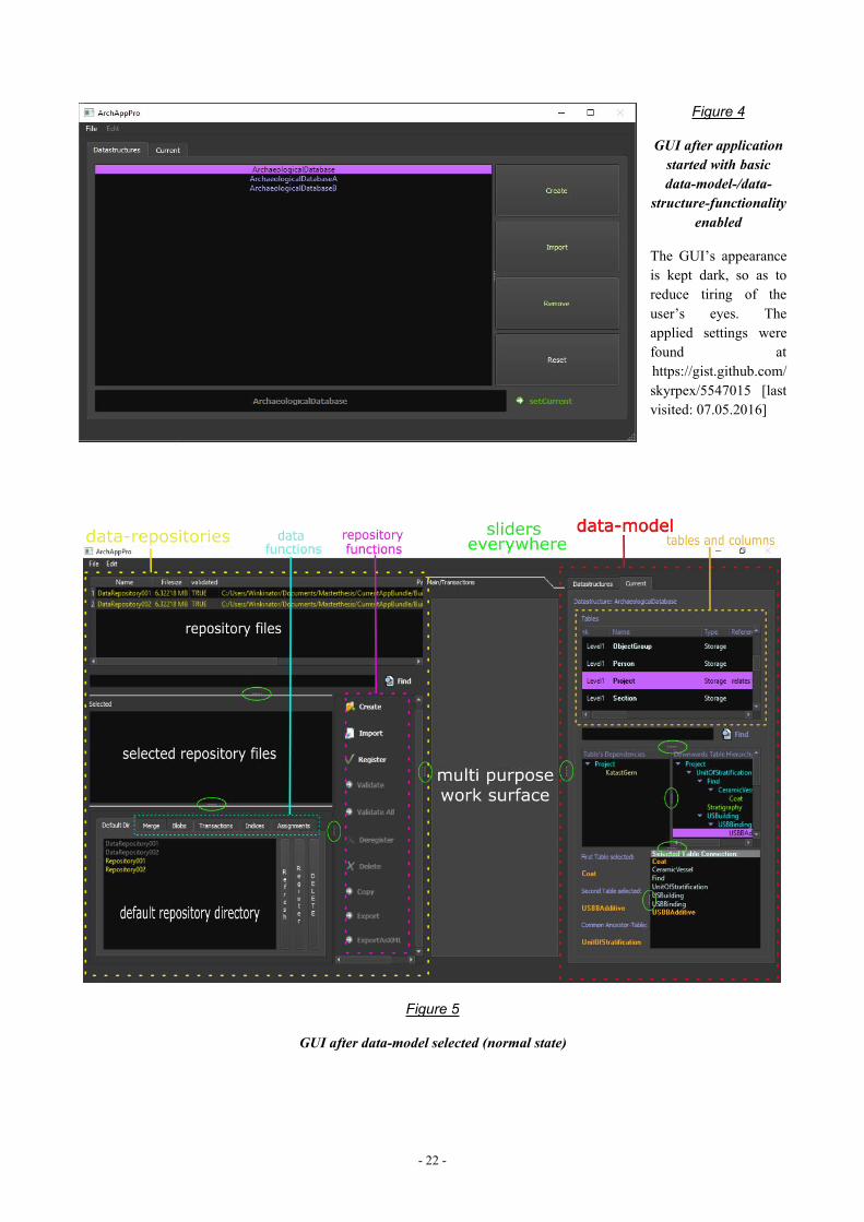
2.4.2. GUI-Overview and the Core Principle
he subsequent page gives a visual overviewof the application’s GraphicalUserInterface, inorder to emit a general impression of the
program as well as a first graphical depiction of themajor functional groups. Thereafter a few centralcharacteristics are to be bespoken.
45 see: http://doc.qt.io/qt-5/signalsandslots.html <last visited:19.02.2017>.46 see: http://www.gnu.de/documents/lgpl-3.0.de/html <lastvisited: 16.02.2017> or https://www.gnu.org/licenses/lgpl-3.0.de.html <last visited: 16.02.2017>.47 see: https://www.qt.io/ide/ <last visited: 16.02.2017>.48 http://doc.qt.io/qt-5/ <last visited: 16.02.2017>.
AI
T
- 22 -
Figure 4
GUI after applicationstarted with basicdata-model-/data-
structure-functionalityenabled
The GUI’s appearanceis kept dark, so as toreduce tiring of theuser’s eyes. Theapplied settings werefound athttps://gist.github.com/skyrpex/5547015 [lastvisited: 07.05.2016]
Figure 5
GUI after data-model selected (normal state)
- 23 -
First of all, Figure 4 and Figure 5 not only representthe GUI’s two major kinds of appearance, but alsoillustrate the essential practice of selecting a data-model - henceforth also called data-structure -(Figure 4), before advanced functionality can beused (Figure 5). It is, hence, not until the applicationenters its (default) tripartite appearance of Figure 5,before most of its functionally grouped bycapabilities become even apparent due to the lattercalling for a valid data-model and the GUI generallyenabling only employable widgets by reason of userfriendliness. A basic feature, thence, is preventingthe change of data-models as long as certain tasksare active. Additionally, as shown by Figure 5, theGUI makes excessive use of window-resizing-sliders, in order to empower the user to enlarge anymajor panel up to nearly the size of the application’smain window.
In order to strive the visual functional componentsof Figure 5, it is to be stated that the pane to theright - including the widgets of Figure 4 by the way- covers all data-model-related functionality, whilethe pane at the left handles all data-repository-related capacity as well as all sorts of database-transactions. In between there lies the main worksurface deployed for displaying forms, query-resultsor a simple map, whereas at the top the edit-menuprovides certain helper-functionality.
Core Principle
For the sake of a positive user-experience theapplication must pursue a policy of self-consistencyand validity - meaning that the program has toprotect itself against an inconsistent state or crashingdue to an error. Roughly at least half of theapplication’s logic is engaged in the task of state-checking and self-healing trying, however, not toslow down the processes noticeably. The state-checking and self-healing begins at the start-up ofthe application, when external dependencies areverified, and includes the attempt of restoringimportant files like the data-model-scheme (see2.2.1. Scheme) and de-registering invalid data-models or database-files. In a nutshell, it iscommonly the external files and directories, thatmight suffer from corruption (probably due to user-
interaction) and have to be repaired or replaced bythe program.
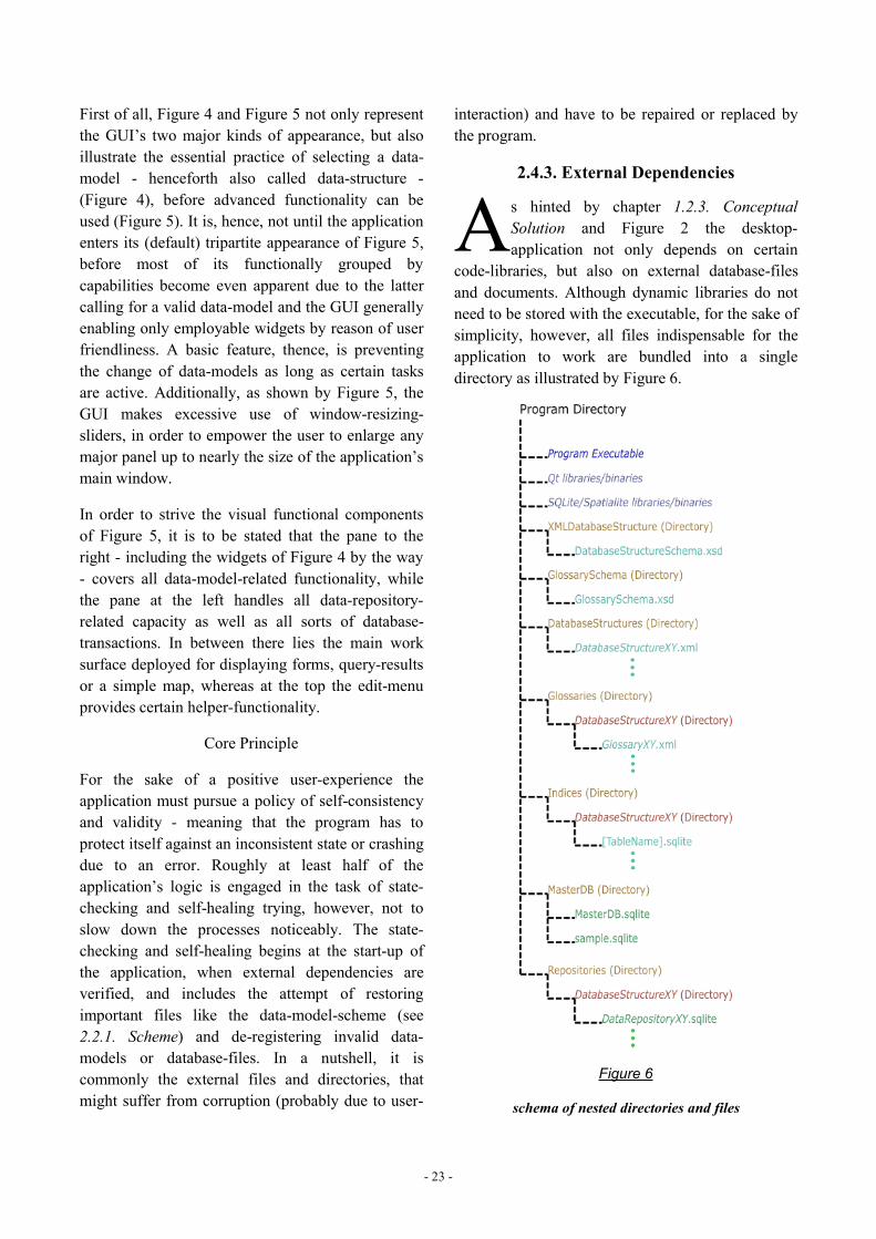
2.4.3. External Dependencies
s hinted by chapter 1.2.3. ConceptualSolution and Figure 2 the desktop-application not only depends on certain
code-libraries, but also on external database-filesand documents. Although dynamic libraries do notneed to be stored with the executable, for the sake ofsimplicity, however, all files indispensable for theapplication to work are bundled into a singledirectory as illustrated by Figure 6.
Figure 6
schema of nested directories and files
A
- 24 -
Beside the already mentioned Qt-libraries/binariesas well as the schemes for glossaries and data-models (data-structures) Figure 6 exposes theexistence of a directory for the data-modeldocuments as well as directories for glossary-documents, database-files utilised as indices (seechapter 2.4.5.12. External Indices) and repositories,each subdivided by directories named after availabledata-models. The folder containing the so called
master-database also holds a database-file namedsample.sqlite, which is needed as prototype fornewly created repositories. Like Qt SpatiaLite (seechapter 2.4.4.3. SQLite and SpatiaLite) depends oncertain libraries/binaries preferably stored with theexecutable, even though the way linked program-libraries are looked up is determined by theoperating system.
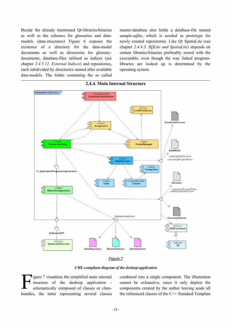
2.4.4. Main Internal Structure
Figure 7
UML-compliant diagram of the desktop-application
igure 7 visualises the simplified main internalstructure of the desktop application -schematically composed of classes or class-
bundles, the latter representing several classes
combined into a single component. The illustrationcannot be exhaustive, since it only depicts thecomponents created by the author leaving aside allthe referenced classes of the C++ Standard Template
F
- 25 -
Library49 and the Qt-libraries. Figure 7, however,suffices to discern the rough overall functionalityfeaturing a GraphicalUserInterface at the top-end beingsupplied advanced capabilities chiefly by two otherclasses, the ConnectionUtility and theThreadManager themselves referencing the fourthclass called Assignment. The reason for that kind ofheavily interconnected arrangement is rooted in theattempt to implement concurrency put into effectmostly by the ThreadManager-class. If the lattercares about, how things are carried out on theoperating system, it is usually the ConnectionUtilityspecifying what has to be done. The Assignment-class, thereby, serves as vehicle between theinstances forming the transport-box enclosing thefunction intended to be scheduled for execution on aseparate thread by the ThreadManager. In doing so,the GUI constitutes commonly both, starting pointas well as the projection area for the executedfunction’s results. The ConnectionUtility-class forits part relies on the one hand on SQLite for basicdatabase-tasks, on the other hand on a couple ofclasses representing the data-model.
Even though it generally appears good practice tosource out expensive tasks to worker-threads, inorder not to have the GraphicalUserInterface blocked, thekey concept built into the application’s structure isits ambition to exploit the hardware’s resources interms of concurrency - a.k.a. multithreading - atmost. As the program will have to handle severaldatabases at once, parallel processing not onlycomes in handy, but is desperately in need. Thetheory behind it additionally presumes that theworkload will be somewhat related to hardwarecapacities, as one would hardly run large-scaleprojects on a poorly performing machine. Therequirement of scaling well with the hardware is,hence, fulfilled, too.
Although the extent of this paper does not suffice toillustrate all the source code - not even the contentof the header files -, the following sections discussthe various components in more detail mainlyutilizing conceptual graphics rather than longepisodes of source code.
49 see: Josuttis 2012.
2.4.4.1. ThreadManager, Assignment andLockFreeQueue
eside referencing C++- and Qt-libraries theapplication consigns three of its components,
namely ThreadManager, Assignment andLockFreeQueue to bring concurrency to life. Likerevealed by Williams [2012] - the source ofinformation on concurrency concerning C++ inregard of this paper - creating a thread and assigningit a task for execution is not a difficult venture,managing access to shared variables and resources,however, is the key challenge. While in this regardthere are locks, so called mutexes, to serializesharing, more sophisticated methods work lock-freetrusting in the application’s design or atomicvariables. [Williams 2012] The desktop-applicationutilizes both approaches and although there is both,concurrency support in Qt50 as well as in native C++,only the latter is applied here. In terms of nativeC++-concurrency and Qt’s signal-slot-mechanism, acertain behaviour is to be noticed with Qt beingcapable of receiving signals only on theGraphicalUserInterface’s thread - apparently due to itsevent loop. The mechanism accomplished by thethree aforementioned components roughly works insuch a way that the task to be done is specified in anAssignment-object and handed over to theThreadManager-object, which schedules the task forexecution by storing and retrieving it in a lock-freequeue.
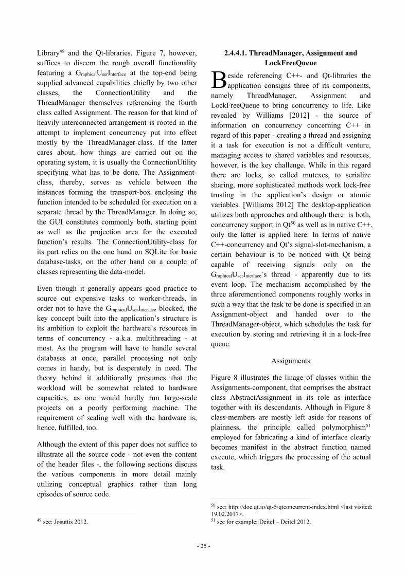
Assignments
Figure 8 illustrates the linage of classes within theAssignments-component, that comprises the abstractclass AbstractAssignment in its role as interfacetogether with its descendants. Although in Figure 8class-members are mostly left aside for reasons ofplainness, the principle called polymorphism51
employed for fabricating a kind of interface clearlybecomes manifest in the abstract function namedexecute, which triggers the processing of the actualtask.
50 see: http://doc.qt.io/qt-5/qtconcurrent-index.html <last visited:19.02.2017>.51 see for example: Deitel – Deitel 2012.
B
- 26 -
Figure 8
class diagram of assignments displaying only members of AbstractAssignment
The multitude of AbstractAssignment’s child-classes is well-founded in the insight that diversetasks require different sets of parametersaccompanying the various functions to execute.Inheritance from QObject is due to assignmentssending out a certain signal indicating completion.Additionally, some assignments apply morecomplicated mechanisms, in order to coordinatetheir behaviour as a group. Assignments neitherhave to be threadsafe themselves nor require a copy-constructor, since they are instantiated as pointers.
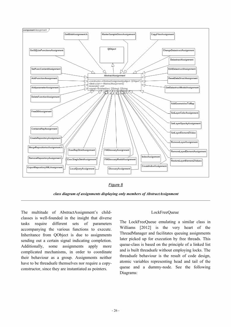
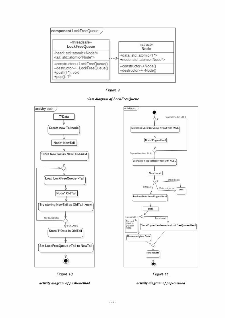
LockFreeQueue
The LockFreeQueue emulating a similar class inWilliams [2012] is the very heart of theThreadManager and facilitates queuing assignmentslater picked up for execution by free threads. Thisqueue-class is based on the principle of a linked listand is built threadsafe without employing locks. Thethreadsafe behaviour is the result of code design,atomic variables representing head and tail of thequeue and a dummy-node. See the followingDiagrams:
- 27 -
Figure 9
class diagram of LockFreeQueue
Figure 10
activity diagram of push-method
Figure 11
activity diagram of pop-method
- 28 -
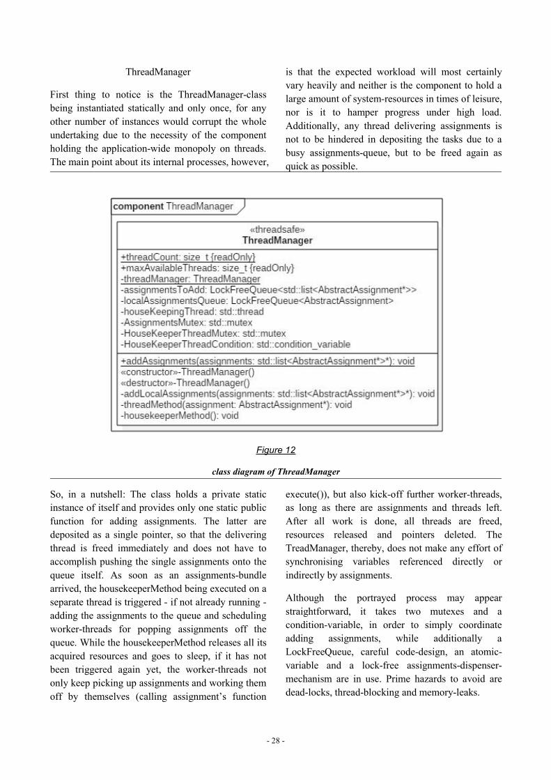
ThreadManager
First thing to notice is the ThreadManager-classbeing instantiated statically and only once, for anyother number of instances would corrupt the wholeundertaking due to the necessity of the componentholding the application-wide monopoly on threads.The main point about its internal processes, however,
is that the expected workload will most certainlyvary heavily and neither is the component to hold alarge amount of system-resources in times of leisure,nor is it to hamper progress under high load.Additionally, any thread delivering assignments isnot to be hindered in depositing the tasks due to abusy assignments-queue, but to be freed again asquick as possible.
Figure 12
class diagram of ThreadManager
So, in a nutshell: The class holds a private staticinstance of itself and provides only one static publicfunction for adding assignments. The latter aredeposited as a single pointer, so that the deliveringthread is freed immediately and does not have toaccomplish pushing the single assignments onto thequeue itself. As soon as an assignments-bundlearrived, the housekeeperMethod being executed on aseparate thread is triggered - if not already running -adding the assignments to the queue and schedulingworker-threads for popping assignments off thequeue. While the housekeeperMethod releases all itsacquired resources and goes to sleep, if it has notbeen triggered again yet, the worker-threads notonly keep picking up assignments and working themoff by themselves (calling assignment’s function
execute()), but also kick-off further worker-threads,as long as there are assignments and threads left.After all work is done, all threads are freed,resources released and pointers deleted. TheTreadManager, thereby, does not make any effort ofsynchronising variables referenced directly orindirectly by assignments.
Although the portrayed process may appearstraightforward, it takes two mutexes and acondition-variable, in order to simply coordinateadding assignments, while additionally aLockFreeQueue, careful code-design, an atomic-variable and a lock-free assignments-dispenser-mechanism are in use. Prime hazards to avoid aredead-locks, thread-blocking and memory-leaks.
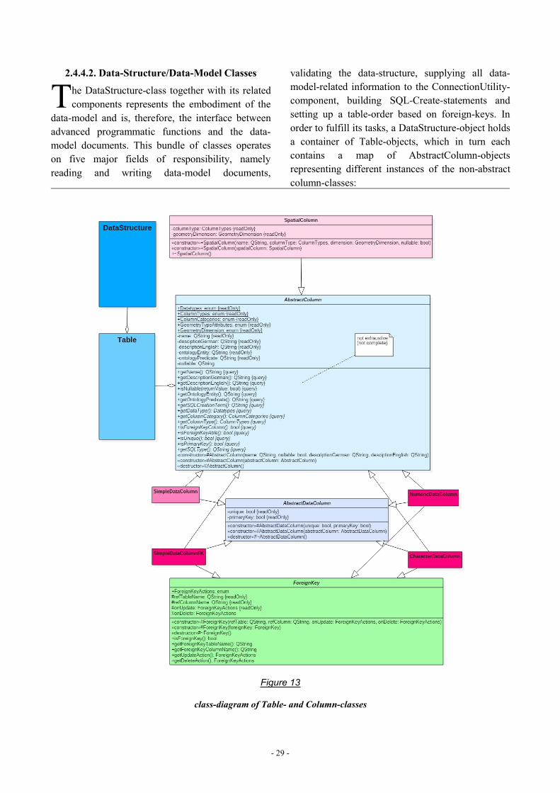
- 29 -
2.4.4.2. Data-Structure/Data-Model Classes
he DataStructure-class together with its relatedcomponents represents the embodiment of the
data-model and is, therefore, the interface betweenadvanced programmatic functions and the data-model documents. This bundle of classes operateson five major fields of responsibility, namelyreading and writing data-model documents,
validating the data-structure, supplying all data-model-related information to the ConnectionUtility-component, building SQL-Create-statements andsetting up a table-order based on foreign-keys. Inorder to fulfill its tasks, a DataStructure-object holdsa container of Table-objects, which in turn eachcontains a map of AbstractColumn-objectsrepresenting different instances of the non-abstractcolumn-classes:
Figure 13
class-diagram of Table- and Column-classes
T
- 30 -
Figure 13 intends to convey a glimpse of the prettystraightforward character of the data-model-component, for a detailed stochastic treatise of theTable- or the DataStructure-class could easilydouble the extent of this paper without, however,contributing essentially to the general understandingof the application. The basic purpose of thiscomponent rests in retrieving, storing anddispensing information on the data-structure.
In order to review the important features, though,beginning with the most elementary, the mechanismof reading and writing eXtensibleMarkupLanguage-files, isto be elucidated by remarking that the utilised Qtclasses rely on the so called DataObjectModel-tree52.This means that eXtensibleMarkupLanguage-elements and -attributes are not read or written line by line, but in asingle event constituting a full tree of nodes. Incontrast to reading serially the downside of thismechanism is a somewhat reduced capacity in termsof document-size, while providing an easy-to-useinterface to eXtensibleMarkupLanguage-documents.
As in this context writing a valid data-model to filebarely stands for a major obstacle, validating suchstructure after having read a data-model from file isa central concern. The first level of validationinvolves verifying the eXtensibleMarkupLanguage-document with the XSD-schema by applying aQXmlSchemaValidator53. Consequently, not only doTable-objects control column-types, naming-conventions and -uniqueness, but the DataStructure-object conducts similar measures in regard of tables.
Additionally, the constraints enumerated in chapter2.3. Glossaries have to be enforced by the data-structure. Besides, every table must have at least oneprimary-key-column, which must not be spatial, andneeds to be related to at least one other table viaforeign-key. On the other hand, foreign-keys mustnot lead in circles, for the model actually has toform some sort of tree. The specified indices have torefer to columns actually existing, while indices forforeign-key-columns as well as spatial-columns arecreated by the program automatically. If the
52 see: http://doc.qt.io/qt-5/xml-dom-tml.html <last visited:21.02.2017>.53 see: http://doc.qt.io/qt-5/QXmlSchemaValidator.html <lastvisited: 21.02.2017>.
component is unable to establish a table order fromforeign-key-relations (the less a table referencesother tables, the closer it is to the root), thevalidation is to fail.
Another major responsibility of the component isgenerating SQL-Create-statements for setting up thedata-structure in database-files. The statements are,thereby, prepared as a single transaction, so as tosucceed or fail completely not leaving behind aninconsistent state. By the way, a similar focus onconsistency holds true for the component itself, inthat it involves large parts of the source-code withfile- and consistency-checking, so that only a validdata-model gets represented by the component.
2.4.4.3. SQLite and SpatiaLite
QLite54, the database-system selected out ofreasons already laid out (see chapter 1.2.3.
Conceptual Solution), can be used completely freely,as stated by the following quotation:
“All of the code and documentation in SQLite hasbeen dedicated to the public domain by the authors.All code authors, and representatives of thecompanies they work for, have signed affidavitsdedicating their contributions to the public domainand originals of those signed affidavits are stored ina firesafe at the main offices of Hwaci. Anyone isfree to copy, modify, publish, use, compile, sell, ordistribute the original SQLite code, either in sourcecode form or as a compiled binary, for any purpose,commercial or non-commercial, and by anymeans.[...]” [https://www.sqlite.org/copyright.html<last visited: 21.02.2017>]
Another advantage of SQLite over other database-systems is its source code amalgamation55 beingready for inclusion directly into the application’ssource code, so that the interaction with SQLitefollows the rules of C++. Since SQLite permitsseveral compile-time options56, some of whichimpact the result heavily, corresponding parametershave to be set in the development environment or -
54 see: https://www.sqlite.org/<last visited: 21.02.2017>.55 see: https://www.sqlite.org/download.html <last visited:21.02.2017>.56 https://www.sqlite.org/compile.html <last visited:21.02.2017>.
S
- 31 -
as practised here - the sqlite-source-code iscompiled to object-code applying aforesaid optionsin MinGW57, before the object-code-file is includedin the application’s code. The compile-commandreads as follows:
gcc -c sqlite/sqlite3.c -o sqlite/sqlite3.o -Os-DSQLITE_THREADSAFE=2-DSQLITE_LIKE_DOESNT_MATCH_BLOBS-DSQLITE_MAX_EXPR_DEPTH=0-DSQLITE_OMIT_DEPRECATED-DSQLITE_DEFAULT_AUTOMATIC_INDEX=1-DSQLITE_DEFAULT_FILE_FORMAT=4-DSQLITE_DEFAULT_FOREIGN_KEYS=1-DSQLITE_DEFAULT_LOCKING_MODE=0-DSQLITE_DEFAULT_SYNCHRONOUS=3-DSQLITE_DEFAULT_WAL_SYNCHRONOUS=3-DSQLITE_DEFAULT_WORKER_THREADS=30-DSQLITE_MAX_WORKER_THREADS=50-DSQLITE_MAX_ATTACHED=100-DSQLITE_CASE_SENSITIVE_LIKE-DSQLITE_TEMP_STORE=1-DSQLITE_ENABLE_COLUMN_METADATA-DSQLITE_ENABLE_FTS3-DSQLITE_ENABLE_FTS3_PARENTHESIS-DSQLITE_ENABLE_FTS3_TOKENIZER-DSQLITE_ENABLE_FTS4-DSQLITE_ENABLE_FTS5-DSQLITE_ENABLE_ICU-DSQLITE_ENABLE_JSON1-DSQLITE_ENABLE_LOCKING_STYLE-DSQLITE_ENABLE_MEMORY_MANAGEMENT-DSQLITE_ENABLE_PREUPDATE_HOOK-DSQLITE_ENABLE_RBU-DSQLITE_ENABLE_RTREE-DSQLITE_ENABLE_SESSION-DSQLITE_ENABLE_UNKNOWN_SQL_FUNCTION-DSQLITE_ENABLE_UNLOCK_NOTIFY
Although among the enumerated parameters severalonly serve as forethought in terms of extending theapplication in future, probably the most important ofthe other options are SQLITE_THREADSAFE andSQLITE_DEFAULT_SYNCHRONOUS, because theyfacilitate concurrent access to single database-files58.Even though concurrency is additionally managed inthe application’s logic, the databases will be
57 see: www.mingw.org/ <last visited: 21.02.2017> or Gough –Stallman 2005.58 see: https://www.sqlite.org/threadsafe.html <last visited:21.02.2017> andhttps://www.sqlite.org/pragma.html#pragma_synchronous <lastvisited: 21.02.2017>.
accessed by server-side scripts, too, therebybypassing the program’s logic.
In order to accomplish foreign-key-enforcement aswell as spatial indices,SQLITE_DEFAULT_FOREIGN_KEYS = 1 andSQLITE_ENABLE_RTREE are set. The multitudeof available options gives an impression of SQLite’scapabilities, only a subset of which is actuallyemployed in the desktop application.
SpatiaLite, on the other hand, is a spatial extensionto the database-system and subject to slightlydifferent open-source licensing terms similar to Qt.59SpatiaLite has to be compiled into operating-system-specific libraries60, in order to be referenced bySQLite. Since the application is programmed on awindows operating-system, this endeavour luckilycan fall back to pre-built windows binaries61.
SQLite’s mechanism of loading an extension is -from the user’s point of view - based oncommunicating the file-path of the extension to theprogram, which may be achieved via C-ApplicationProgrammingInterface-function.62 Since due tolicensing issues dynamic binding via shared librariesis to prefer over static linking anyway, a certainvariation of the dynamic process is available (andtherefore utilised here), making SpatiaLite a purelyloadable module connected by SQL-statement.63After loading succeeded, spatial meta-data has to beinitialised by the SQL-command “SELECTInitSpatialMetaData()” [http://www.gaia-gis.it/gaia-sins/spatialite-cookbook/html/metadata.html <lastvisited: 23.02.2017>], which can take up to severalminutes to finish.
59 see: https://www.gaia-gis.it/fossil/libspatialite/index <lastvisited: 21.02.2017>.60 see: www.gaia-gis.it/gaia-sins/sqlite-doxy-4.3.0/index.html<last visited: 21.02.2017> and www.gaia-gis.it/gaia-sins/ <lastvisited: 21.02.2017>.61 Available at: www.gaia-gis.it/gaia-sins/ <last visited:21.02.2017>.62 https://www.sqlite.org/loadext.html <last visited:23.02.2017>.63 https://www.gaia-gis.it/fossil/libspatialite/wiki?name=mod_spatialite <last visited: 23.02.2017>.
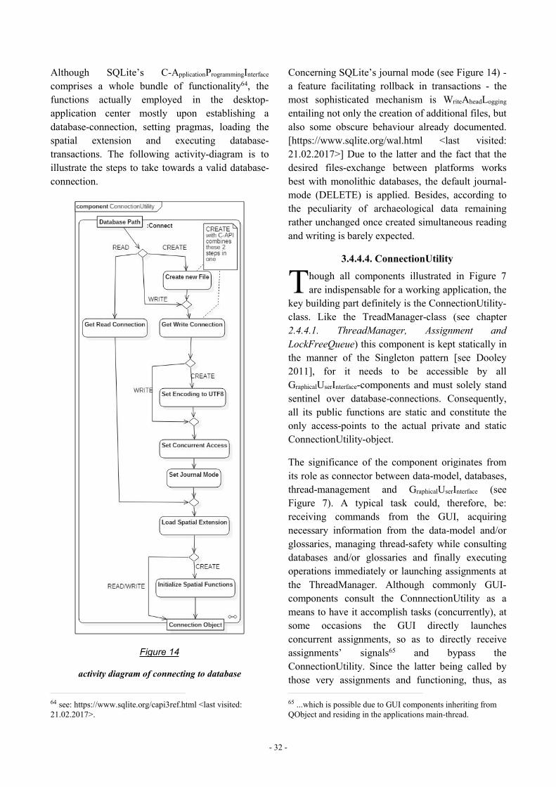
- 32 -
Although SQLite’s C-ApplicationProgrammingInterfacecomprises a whole bundle of functionality64, thefunctions actually employed in the desktop-application center mostly upon establishing adatabase-connection, setting pragmas, loading thespatial extension and executing database-transactions. The following activity-diagram is toillustrate the steps to take towards a valid database-connection.
Figure 14
activity diagram of connecting to database
64 see: https://www.sqlite.org/capi3ref.html <last visited:21.02.2017>.
Concerning SQLite’s journal mode (see Figure 14) -a feature facilitating rollback in transactions - themost sophisticated mechanism is WriteAheadLogging
entailing not only the creation of additional files, butalso some obscure behaviour already documented.[https://www.sqlite.org/wal.html <last visited:21.02.2017>] Due to the latter and the fact that thedesired files-exchange between platforms worksbest with monolithic databases, the default journal-mode (DELETE) is applied. Besides, according tothe peculiarity of archaeological data remainingrather unchanged once created simultaneous readingand writing is barely expected.
3.4.4.4. ConnectionUtility
hough all components illustrated in Figure 7are indispensable for a working application, the
key building part definitely is the ConnectionUtility-class. Like the TreadManager-class (see chapter2.4.4.1. ThreadManager, Assignment andLockFreeQueue) this component is kept statically inthe manner of the Singleton pattern [see Dooley2011], for it needs to be accessible by allGraphicalUserInterface-components and must solely standsentinel over database-connections. Consequently,all its public functions are static and constitute theonly access-points to the actual private and staticConnectionUtility-object.
The significance of the component originates fromits role as connector between data-model, databases,thread-management and GraphicalUserInterface (seeFigure 7). A typical task could, therefore, be:receiving commands from the GUI, acquiringnecessary information from the data-model and/orglossaries, managing thread-safety while consultingdatabases and/or glossaries and finally executingoperations immediately or launching assignments atthe ThreadManager. Although commonly GUI-components consult the ConnnectionUtility as ameans to have it accomplish tasks (concurrently), atsome occasions the GUI directly launchesconcurrent assignments, so as to directly receiveassignments’ signals65 and bypass theConnectionUtility. Since the latter being called bythose very assignments and functioning, thus, as
65 ...which is possible due to GUI components inheriting fromQObject and residing in the applications main-thread.
T
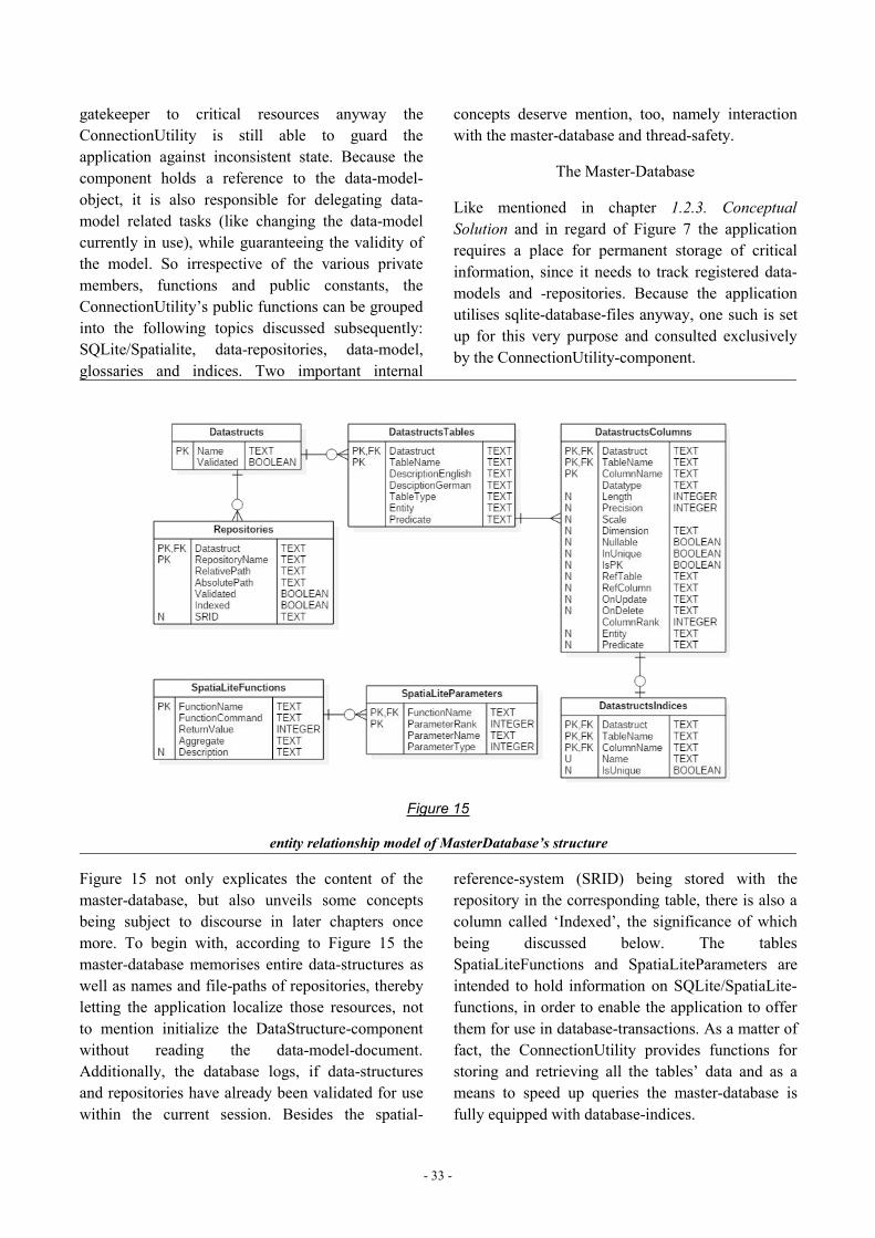
- 33 -
gatekeeper to critical resources anyway theConnectionUtility is still able to guard theapplication against inconsistent state. Because thecomponent holds a reference to the data-model-object, it is also responsible for delegating data-model related tasks (like changing the data-modelcurrently in use), while guaranteeing the validity ofthe model. So irrespective of the various privatemembers, functions and public constants, theConnectionUtility’s public functions can be groupedinto the following topics discussed subsequently:SQLite/Spatialite, data-repositories, data-model,glossaries and indices. Two important internal
concepts deserve mention, too, namely interactionwith the master-database and thread-safety.
The Master-Database
Like mentioned in chapter 1.2.3. ConceptualSolution and in regard of Figure 7 the applicationrequires a place for permanent storage of criticalinformation, since it needs to track registered data-models and -repositories. Because the applicationutilises sqlite-database-files anyway, one such is setup for this very purpose and consulted exclusivelyby the ConnectionUtility-component.
Figure 15
entity relationship model of MasterDatabase’s structure
Figure 15 not only explicates the content of themaster-database, but also unveils some conceptsbeing subject to discourse in later chapters oncemore. To begin with, according to Figure 15 themaster-database memorises entire data-structures aswell as names and file-paths of repositories, therebyletting the application localize those resources, notto mention initialize the DataStructure-componentwithout reading the data-model-document.Additionally, the database logs, if data-structuresand repositories have already been validated for usewithin the current session. Besides the spatial-
reference-system (SRID) being stored with therepository in the corresponding table, there is also acolumn called ‘Indexed’, the significance of whichbeing discussed below. The tablesSpatiaLiteFunctions and SpatiaLiteParameters areintended to hold information on SQLite/SpatiaLite-functions, in order to enable the application to offerthem for use in database-transactions. As a matter offact, the ConnectionUtility provides functions forstoring and retrieving all the tables’ data and as ameans to speed up queries the master-database isfully equipped with database-indices.
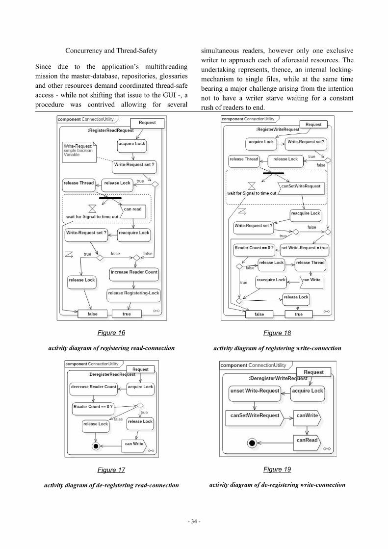
- 34 -
Concurrency and Thread-Safety
Since due to the application’s multithreadingmission the master-database, repositories, glossariesand other resources demand coordinated thread-safeaccess - while not shifting that issue to the GUI -, aprocedure was contrived allowing for several
simultaneous readers, however only one exclusivewriter to approach each of aforesaid resources. Theundertaking represents, thence, an internal locking-mechanism to single files, while at the same timebearing a major challenge arising from the intentionnot to have a writer starve waiting for a constantrush of readers to end.
Figure 16
activity diagram of registering read-connection
Figure 17
activity diagram of de-registering read-connection
Figure 18
activity diagram of registering write-connection
Figure 19
activity diagram of de-registering write-connection
- 35 -
The Activity-Diagrams of Figure 16 and Figure 18illustrate the processes of registering the wish foraccessing a certain resource, whereas Figure 17 andFigure 19 display the corresponding de-registeringacts, more precisely the announcements of havingfinished resource-interaction. The boolean return-values, thereby, indicate the success of the attempt.
The mechanism comprising all four illustratedprocedures involves one lock/mutex, threecondition-variables represented in the figures bysignals, a boolean Write-Request-variable and aReader-Counter, in order to meet aforementionedexpectations regarding a writer’s precedence overreaders. While there is actually no mutex or file-lockpreventing resource access, as the applied lockingonly serializes the registering-process, the thread-safety is nonetheless preserved, as long as the actualfile-interaction is enclosed by the correspondingregistering/de-registering functions of Figures 16 to19.
According to that principle, not only the masterdatabase is guarded against unwanted side-effects ofconcurrent access, but also glossaries andrepositories, the latter two, however, in a ratherdynamic fashion. This means that for the time ofresource-interaction the above mentionedcorresponding variables (mutex, condition-variablesetc.) are stored in a map (once for each resource)and deleted, after interaction is finished.
In order to round up the picture on concurrencypractised in the ConnectionUtility, it must be statedthat further measures are taken and additionalmutexes involved operating on a rather ‘global’level assuring full thread-safety.
SQLite/SpatiaLite-Functions
SpatiaLite, even more than SQLite, comes withseveral build-in functions66 applicable in database-transactions and essential for spatial tasks. Since theGraphicalUserInterface provides a query-form (see chapter2.4.5.6. QueryBuilder-Form), those functions arekept at disposal in the master-database and areretrieved and stored via the ConnectionUtility.
66 https://www.gaia-gis.it/gaia-sins/spatialite-sql-4.4.0.html<last visited: 30.04.2017>.
(Data-)Repositories
Because data-repositories are the major concern ofthe ConnectionUtlity, most functions center uponthe following thematic categories, namely setting upthe data-model in the database-file, validating therepositories’ content, importing, registering, creating,exporting, copying, merging as well as removingrepositories and finally actual database-transactionsfor data-management, not to mention several helper-utilities.
In doing so, those tasks act upon two different levels,namely files-level and database-internal, the mostbasic among the latter being the first two ofaforesaid areas of application, for they both areemployed - directly or indirectly - in several otherfunctions. The setting-up of the data-model in arepository-file is, thereby, achieved by a singletransaction containing all necessary Create-statements originating form the DataStructure-object,so that in a second step glossary-values kept in theXML-documents can be inserted. The validation ofrepositories, too, relies heavily on the data-modeland takes advantage of SQLite’s automaticallygenerated metadata, which for this purpose iscompared to data-model-data in the DataStructure-object. Optionally within this procedure, glossary-values are checked making the validation-processconceivably a relatively long-lasting task.Irrespective of conventional database-transactions -although complex since tailored for the GUI’s needs- the ability of merging and copying database-filesdeserves mention, as they - together with repository-indices (see below) - break up the rather staticseparation of data into different database-files.
As indicated by the term of aforementioned firstlevel of application, a lot of file-handling is involveddue to the program’s mission to herd a group ofdatabase-files. This includes not only keeping thedirectories of the application’s externaldependencies tidy and free of unwanted files, butalso synchronising registered repositories withrepository-files actually existing. Additionally, inthe context of repositories most functions entailconsulting the master-database, be it for queryingthe path to a repository, be it for changing theregistration-status of a repository-file.
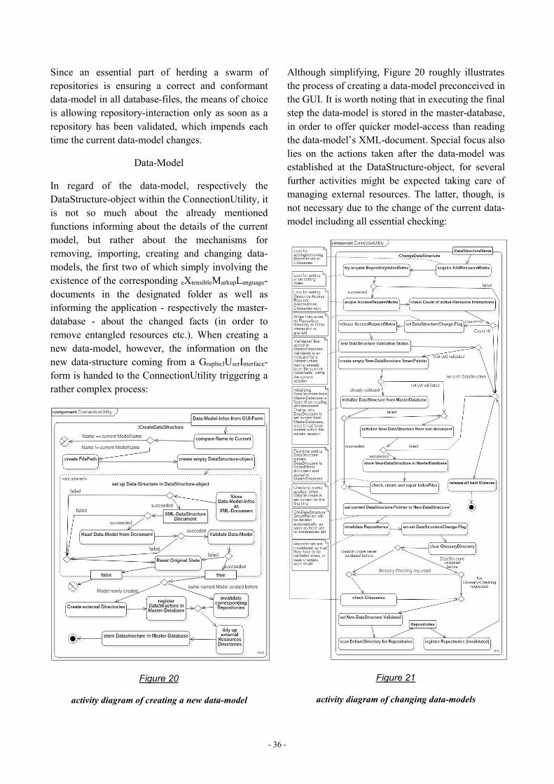
- 36 -
Since an essential part of herding a swarm ofrepositories is ensuring a correct and conformantdata-model in all database-files, the means of choiceis allowing repository-interaction only as soon as arepository has been validated, which impends eachtime the current data-model changes.
Data-Model
In regard of the data-model, respectively theDataStructure-object within the ConnectionUtility, itis not so much about the already mentionedfunctions informing about the details of the currentmodel, but rather about the mechanisms forremoving, importing, creating and changing data-models, the first two of which simply involving theexistence of the corresponding eXtensibleMarkupLanguage-documents in the designated folder as well asinforming the application - respectively the master-database - about the changed facts (in order toremove entangled resources etc.). When creating anew data-model, however, the information on thenew data-structure coming from a GraphiclUserInterface-form is handed to the ConnectionUtility triggering arather complex process:
Figure 20
activity diagram of creating a new data-model
Although simplifying, Figure 20 roughly illustratesthe process of creating a data-model preconceived inthe GUI. It is worth noting that in executing the finalstep the data-model is stored in the master-database,in order to offer quicker model-access than readingthe data-model’s XML-document. Special focus alsolies on the actions taken after the data-model wasestablished at the DataStructure-object, for severalfurther activities might be expected taking care ofmanaging external resources. The latter, though, isnot necessary due to the change of the current data-model including all essential checking:
Figure 21
activity diagram of changing data-models
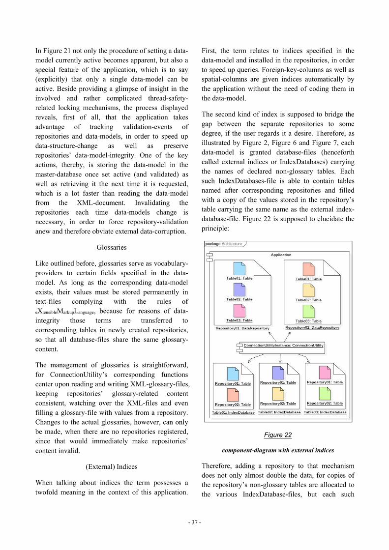
- 37 -
In Figure 21 not only the procedure of setting a data-model currently active becomes apparent, but also aspecial feature of the application, which is to say(explicitly) that only a single data-model can beactive. Beside providing a glimpse of insight in theinvolved and rather complicated thread-safety-related locking mechanisms, the process displayedreveals, first of all, that the application takesadvantage of tracking validation-events ofrepositories and data-models, in order to speed updata-structure-change as well as preserverepositories’ data-model-integrity. One of the keyactions, thereby, is storing the data-model in themaster-database once set active (and validated) aswell as retrieving it the next time it is requested,which is a lot faster than reading the data-modelfrom the XML-document. Invalidating therepositories each time data-models change isnecessary, in order to force repository-validationanew and therefore obviate external data-corruption.
Glossaries
Like outlined before, glossaries serve as vocabulary-providers to certain fields specified in the data-model. As long as the corresponding data-modelexists, their values must be stored permanently intext-files complying with the rules ofeXtensibleMarkupLanguage, because for reasons of data-integrity those terms are transferred tocorresponding tables in newly created repositories,so that all database-files share the same glossary-content.
The management of glossaries is straightforward,for ConnectionUtility’s corresponding functionscenter upon reading and writing XML-glossary-files,keeping repositories’ glossary-related contentconsistent, watching over the XML-files and evenfilling a glossary-file with values from a repository.Changes to the actual glossaries, however, can onlybe made, when there are no repositories registered,since that would immediately make repositories’content invalid.
(External) Indices
When talking about indices the term possesses atwofold meaning in the context of this application.
First, the term relates to indices specified in thedata-model and installed in the repositories, in orderto speed up queries. Foreign-key-columns as well asspatial-columns are given indices automatically bythe application without the need of coding them inthe data-model.
The second kind of index is supposed to bridge thegap between the separate repositories to somedegree, if the user regards it a desire. Therefore, asillustrated by Figure 2, Figure 6 and Figure 7, eachdata-model is granted database-files (henceforthcalled external indices or IndexDatabases) carryingthe names of declared non-glossary tables. Eachsuch IndexDatabases-file is able to contain tablesnamed after corresponding repositories and filledwith a copy of the values stored in the repository’stable carrying the same name as the external index-database-file. Figure 22 is supposed to elucidate theprinciple:
Figure 22
component-diagram with external indices
Therefore, adding a repository to that mechanismdoes not only almost double the data, for copies ofthe repository’s non-glossary tables are allocated tothe various IndexDatabase-files, but each such
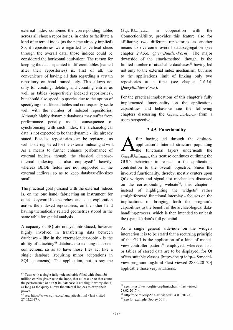
- 38 -
external index combines the corresponding tablesacross all chosen repositories, in order to facilitate akind of external index (as the name already implied).So, if repositories were regarded as vertical slicesthrough the overall data, those indices could beconsidered the horizontal equivalent. The reason forkeeping the data separated in different tables (namedafter their repositories) is, first of all, theconvenience of having all data regarding a certainrepository on hand immediately. This allows notonly for creating, deleting and counting entries aswell as tables (respectively indexed repositories),but should also speed up queries due to the option ofspecifying the affected tables and consequently scalewell with the number of indexed repositories.Although highly dynamic databases may suffer fromperformance penalty as a consequence ofsynchronising with such index, the archaeologicaldata is not expected to be that dynamic - like alreadystated. Besides, repositories can be registered aswell as de-registered for the external indexing at will.As a means to further enhance performance ofexternal indices, though, the classical database-internal indexing is also employed67 heavily,whereas BLOB fields are not supported in theexternal indices, so as to keep database-file-sizessmall.
The practical goal pursued with the external indicesis, on the one hand, fabricating an instrument forquick keyword-like-searches and data-explorationacross the indexed repositories, on the other handhaving thematically related geometries stored in thesame table for spatial analysis.
A capacity of SQLite not yet introduced, howeverhighly involved in transferring data betweendatabases - like in the external-index-topic - is theability of attaching68 databases to existing database-connections, so as to have those files act like asingle database (requiring minor adaptations inSQL-statements). The application, not to say the
67 Tests with a single fully indexed table filled with about 50million entries give rise to the hope, that at least up to that countthe performance of a SQLite-database is nothing to worry about,as long as the query allows the internal indices to exert theirpower.68 see: https://www.sqlite.org/lang_attach.html <last visited27.02.2017>.
GraphiclUserInterface in cooperation with theConnectionUtility, provides this feature also foraffiliating two different repositories as anothermeans to overcome overall data-segregation (seechapter 2.4.5.6. QueryBuilder-Form). The majordownside of the attach-method, though, is thelimited number of attachable databases69 having lednot only to the external index mechanism, but alsoto the applications limit of linking only tworepositories at a time (see chapter 2.4.5.6.QueryBuilder-Form).
For the practical implications of this chapter’s fullyimplemented functionality on the applicationscapabilities and behaviour see the followingchapters discussing the GraphicalUserInterface from ausers perspective.
2.4.5. Functionality
fter having led through the desktop-application’s internal structure populatingthe functional layers underneath the
GraphiclUserInterface, this treatise continues outlining theGUI’s behaviour in respect to the applicationscontribution to the overall objective. Since theinvolved functionality, thereby, mostly centers uponQt’s widgets and signal-slot mechanism discussedon the corresponding website70, this chapter -instead of highlighting the widgets’ ratherstraightforward functional interplay - focuses on theimplications of bringing forth the program’scapabilities to the benefit of the archaeological data-handling-process, which is then intended to unleashthe (spatial-) data’s full potential.
As a single general side-note on the widgetsinteraction it is to be stated that a recurring principleof the GUI is the application of a kind of model-view-controller pattern71 employed, wherever listsor tables of stored data are to be displayed, for Qtoffers suitable classes [http::/doc.qt.io/qt-4.8/model-view-programming.html <last viewed 28.02.2017>]applicable those very situations.
69 see: https://www.sqlite.org/limits.html <last visited28.02.2017>.70 http://doc.qt.io/qt-5/ <last visited: 04.03.2017>.71 see for example Dooley 2011.
A
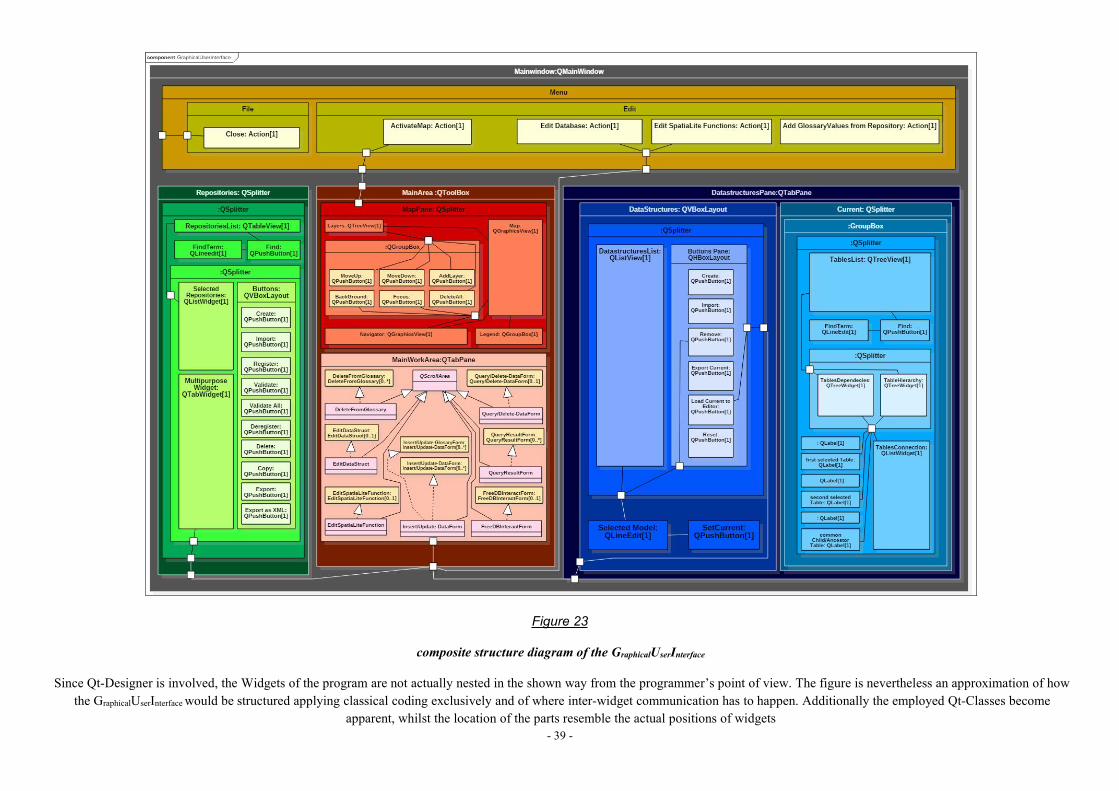
- 39 -
Figure 23
composite structure diagram of the GraphicalUserInterface
Since Qt-Designer is involved, the Widgets of the program are not actually nested in the shown way from the programmer’s point of view. The figure is nevertheless an approximation of howthe GraphicalUserInterfacewould be structured applying classical coding exclusively and of where inter-widget communication has to happen. Additionally the employed Qt-Classes become
apparent, whilst the location of the parts resemble the actual positions of widgets
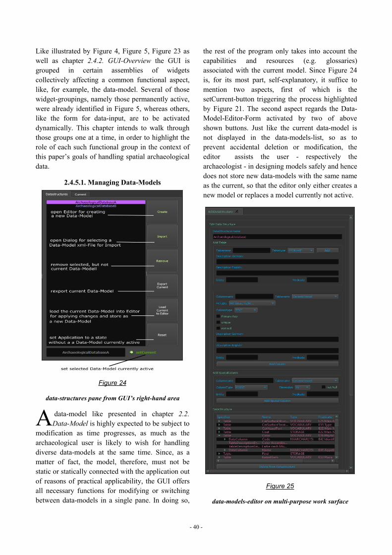
- 40 -
Like illustrated by Figure 4, Figure 5, Figure 23 aswell as chapter 2.4.2. GUI-Overview the GUI isgrouped in certain assemblies of widgetscollectively affecting a common functional aspect,like, for example, the data-model. Several of thosewidget-groupings, namely those permanently active,were already identified in Figure 5, whereas others,like the form for data-input, are to be activateddynamically. This chapter intends to walk throughthose groups one at a time, in order to highlight therole of each such functional group in the context ofthis paper’s goals of handling spatial archaeologicaldata.
2.4.5.1. Managing Data-Models
Figure 24
data-structures pane from GUI’s right-hand area
data-model like presented in chapter 2.2.Data-Model is highly expected to be subject to
modification as time progresses, as much as thearchaeological user is likely to wish for handlingdiverse data-models at the same time. Since, as amatter of fact, the model, therefore, must not bestatic or statically connected with the application outof reasons of practical applicability, the GUI offersall necessary functions for modifying or switchingbetween data-models in a single pane. In doing so,
the rest of the program only takes into account thecapabilities and resources (e.g. glossaries)associated with the current model. Since Figure 24is, for its most part, self-explanatory, it suffice tomention two aspects, first of which is thesetCurrent-button triggering the process highlightedby Figure 21. The second aspect regards the Data-Model-Editor-Form activated by two of aboveshown buttons. Just like the current data-model isnot displayed in the data-models-list, so as toprevent accidental deletion or modification, theeditor assists the user - respectively thearchaeologist - in designing models safely and hencedoes not store new data-models with the same nameas the current, so that the editor only either creates anew model or replaces a model currently not active.
Figure 25
data-models-editor on multi-purpose work surface
A
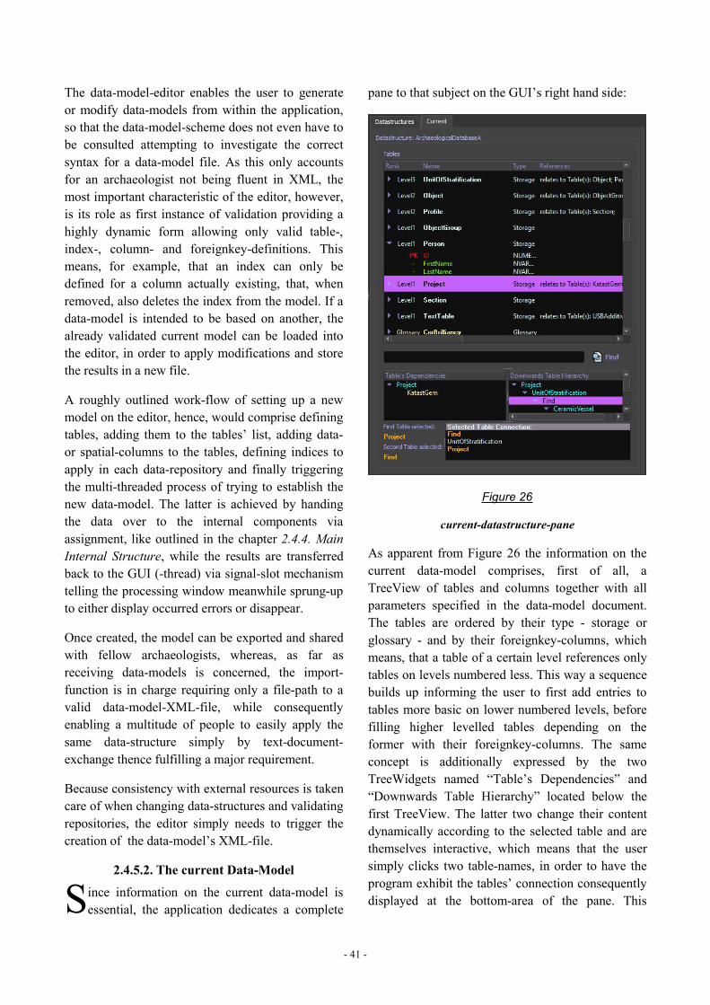
- 41 -
The data-model-editor enables the user to generateor modify data-models from within the application,so that the data-model-scheme does not even have tobe consulted attempting to investigate the correctsyntax for a data-model file. As this only accountsfor an archaeologist not being fluent in XML, themost important characteristic of the editor, however,is its role as first instance of validation providing ahighly dynamic form allowing only valid table-,index-, column- and foreignkey-definitions. Thismeans, for example, that an index can only bedefined for a column actually existing, that, whenremoved, also deletes the index from the model. If adata-model is intended to be based on another, thealready validated current model can be loaded intothe editor, in order to apply modifications and storethe results in a new file.
A roughly outlined work-flow of setting up a newmodel on the editor, hence, would comprise definingtables, adding them to the tables’ list, adding data-or spatial-columns to the tables, defining indices toapply in each data-repository and finally triggeringthe multi-threaded process of trying to establish thenew data-model. The latter is achieved by handingthe data over to the internal components viaassignment, like outlined in the chapter 2.4.4. MainInternal Structure, while the results are transferredback to the GUI (-thread) via signal-slot mechanismtelling the processing window meanwhile sprung-upto either display occurred errors or disappear.
Once created, the model can be exported and sharedwith fellow archaeologists, whereas, as far asreceiving data-models is concerned, the import-function is in charge requiring only a file-path to avalid data-model-XML-file, while consequentlyenabling a multitude of people to easily apply thesame data-structure simply by text-document-exchange thence fulfilling a major requirement.
Because consistency with external resources is takencare of when changing data-structures and validatingrepositories, the editor simply needs to trigger thecreation of the data-model’s XML-file.
2.4.5.2. The current Data-Model
ince information on the current data-model isessential, the application dedicates a complete
pane to that subject on the GUI’s right hand side:
Figure 26
current-datastructure-pane
As apparent from Figure 26 the information on thecurrent data-model comprises, first of all, aTreeView of tables and columns together with allparameters specified in the data-model document.The tables are ordered by their type - storage orglossary - and by their foreignkey-columns, whichmeans, that a table of a certain level references onlytables on levels numbered less. This way a sequencebuilds up informing the user to first add entries totables more basic on lower numbered levels, beforefilling higher levelled tables depending on theformer with their foreignkey-columns. The sameconcept is additionally expressed by the twoTreeWidgets named “Table’s Dependencies” and“Downwards Table Hierarchy” located below thefirst TreeView. The latter two change their contentdynamically according to the selected table and arethemselves interactive, which means that the usersimply clicks two table-names, in order to have theprogram exhibit the tables’ connection consequentlydisplayed at the bottom-area of the pane. ThisS
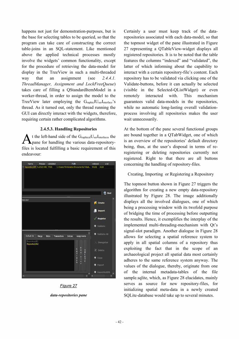
- 42 -
happens not just for demonstration-purposes, but isthe base for selecting tables to be queried, so that theprogram can take care of constructing the correcttable-joins in an SQL-statement. Like mentionedabove the applied technical processes mostlyinvolve the widgets’ common functionality, exceptfor the procedure of retrieving the data-model fordisplay in the TreeView in such a multi-threadedway that an assignment (see 2.4.4.1.ThreadManager, Assignment and LockFreeQueue)takes care of filling a QStandardItemModel in aworker-thread, in order to assign the model to theTreeView later employing the GraphiclUserInterface’sthread. As it turned out, only the thread running theGUI can directly interact with the widgets, therefore,requiring certain rather complicated algorithms.
2.4.5.3. Handling Repositories
t the left-hand side of the GraphicalUserInterfaces thepane for handling the various data-repository-
files is located fulfilling a basic requirement of thisendeavour:
Figure 27
data-repositories pane
Certainly a user must keep track of the data-repositories associated with each data-model, so thatthe topmost widget of the pane illustrated in Figure27 representing a QTableView-widget displays allregistered repositories. It is to be noted that the tablefeatures the columns “indexed” and “validated”, thelatter of which informing about the capability tointeract with a certain repository-file’s content. Eachrepository has to be validated via clicking one of theValidate-buttons, before it can actually be selected(visible in the Selected-QListWidget) or evenremotely interacted with. This mechanismguarantees valid data-models in the repositories,while no automatic long-lasting overall validation-process involving all repositories makes the userwait unnecessarily.
At the bottom of the pane several functional groupsare bound together in a QTabWidget, one of whichis an overview of the repositories’ default directorybeing, thus, at the user’s disposal in terms of re-registering or deleting repositories currently notregistered. Right to that there are all buttonsconcerning the handling of repository-files.
Creating, Importing or Registering a Repository
The topmost button shown in Figure 27 triggers thealgorithm for creating a new empty data-repositoryillustrated by Figure 28. The image additionallydisplays all the involved dialogues, one of whichbeing a processing window with its twofold purposeof bridging the time of processing before outputtingthe results. Hence, it exemplifies the interplay of theimplemented multi-threading-mechanism with Qt’ssignal-slot paradigm. Another dialogue in Figure 28allows for selecting a spatial reference system toapply in all spatial columns of a repository thusexploiting the fact that in the scope of anarchaeological project all spatial data most certainlyadheres to the same reference system anyway. Thevalues of the dialogue, thereby, originate from oneof the internal metadata-tables of the filesample.sqlite, which, as Figure 28 elucidates, mainlyserves as source for new repository-files, forinitializing spatial meta-data in a newly createdSQLite-database would take up to several minutes.
A
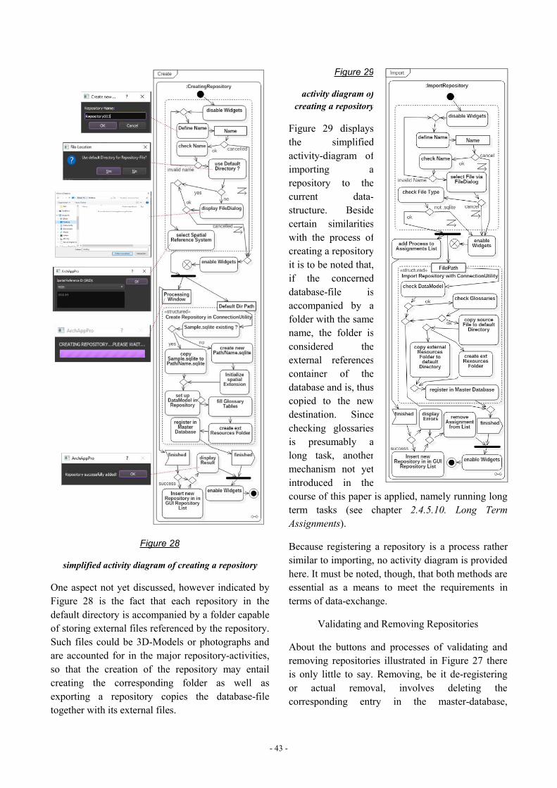
- 43 -
Figure 28
simplified activity diagram of creating a repository
One aspect not yet discussed, however indicated byFigure 28 is the fact that each repository in thedefault directory is accompanied by a folder capableof storing external files referenced by the repository.Such files could be 3D-Models or photographs andare accounted for in the major repository-activities,so that the creation of the repository may entailcreating the corresponding folder as well asexporting a repository copies the database-filetogether with its external files.
Figure 29
activity diagram ofcreating a repository
Figure 29 displaysthe simplifiedactivity-diagram ofimporting arepository to thecurrent data-structure. Besidecertain similaritieswith the process ofcreating a repository,it is to be noted that,if the concerneddatabase-file isaccompanied by afolder with the samename, the folder isconsidered theexternal referencescontainer of thedatabase and is, thus,copied to the newdestination. Sincechecking glossariesis presumably along task, anothermechanism not yetintroduced in thecourse of this paper is applied, namely running longterm tasks (see chapter 2.4.5.10. Long TermAssignments).
Because registering a repository is a process rathersimilar to importing, no activity diagram is providedhere. It must be noted, though, that both methods areessential as a means to meet the requirements interms of data-exchange.
Validating and Removing Repositories
About the buttons and processes of validating andremoving repositories illustrated in Figure 27 thereis only little to say. Removing, be it de-registeringor actual removal, involves deleting thecorresponding entry in the master-database,
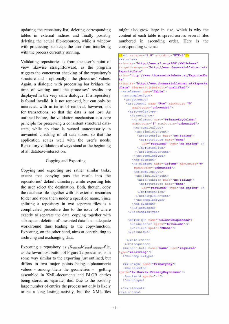
- 44 -
updating the repository-list, deleting correspondingtables in external indices and finally possiblydeleting the actual file-resources, while a windowwith processing bar keeps the user from interferingwith the process currently running.
Validating repositories is from the user’s point ofview likewise straightforward, as the programtriggers the concurrent checking of the repository’sstructure and - optionally - the glossaries’ values.Again, a dialogue with processing bar bridges thetime of waiting until the processes’ results aredisplayed in the very same dialogue. If a repositoryis found invalid, it is not removed, but can only beinteracted with in terms of removal, however, notfor transactions, so that the data is not lost. Asoutlined before, the validation-mechanism is a coreprinciple for preserving a consistent structural data-state, while no time is wasted unnecessarily inunwanted checking of all data-stores, so that theapplication scales well with the user’s needs.Repository validations always stand at the beginningof all database-interaction.
Copying and Exporting
Copying and exporting are rather similar tasks,except that copying puts the result into therepositories’ default directory, while exporting letsthe user select the destination. Both, though, copythe database-file together with its external resourcesfolder and store them under a specified name. Sincesplitting a repository in two separate files is acomplicated procedure due to the issue of whereexactly to separate the data, copying together withsubsequent deletion of unwanted data is an adequateworkaround thus leading to the copy-function.Exporting, on the other hand, aims at contributing toarchiving and exchanging data.
Exporting a repository as eXtensibleMarkupLanguage-file,as the lowermost button of Figure 27 proclaims, is insome way similar to the exporting just outlined, butdiffers in two major points being alphanumericvalues - among them the geometries - gettingassembled in XML-documents and BLOB entriesbeing stored as separate files. Due to the possiblylarge number of entries the process not only is likelyto be a long lasting activity, but the XML-files
might also grow large in size, which is why thecontent of each table is spread across several filesnumbered in ascending order. Here is thecorresponding schema:
<?xml version="1.0" encoding="UTF-8"?><xs:schemaxmlns:xs="http://www.w3.org/2001/XMLSchema"targetNamespace="http://www.thomaswinklehner.at/ExportedData"xmlns="http://www.thomaswinklehner.at/ExportedData"xmlns:tw="http://www.thomaswinklehner.at/ExportedData" elementFormDefault="qualified"><xs:element name="Table"><xs:complexType><xs:sequence><xs:element name="Row" minOccurs="0"
maxOccurs="unbounded"><xs:complexType><xs:sequence><xs:element name="PrimaryKeyColumn"minOccurs="1" maxOccurs="unbounded"><xs:complexType><xs:simpleContent><xs:extension base="xs:string"><xs:attribute name="Name"use="required" type="xs:string" />
</xs:extension></xs:simpleContent></xs:complexType></xs:element><xs:element name="Column" minOccurs="0"maxOccurs="unbounded"><xs:complexType><xs:simpleContent><xs:extension base="xs:string"><xs:attribute name="Name"use="required" type="xs:string" />
</xs:extension></xs:simpleContent></xs:complexType></xs:element></xs:sequence></xs:complexType>
<xs:unique name="ColumnUniqueness"><xs:selector xpath="tw:Column"/><xs:field xpath="@Name"/></xs:unique>
</xs:element></xs:sequence><xs:attribute name="Name" use="required"
type="xs:string"/></xs:complexType>
<xs:unique name="PrimaryKey"><xs:selector
xpath="tw:Row/tw:PrimaryKeyColumn"/><xs:field xpath="."/></xs:unique>
</xs:element></xs:schema>

- 45 -
So the result of this procedure is a folder of aspecified name containing directories named“Tables” and “Files”, first of which comprisingdirectories named after the repository’s tables(glossaries excluded). Within them aforesaid XML-files describing all the alphanumeric values of theparticular table together with according BLOB-values are stored, while within the Files-directory allthe repository’s external resources can be found.Whereas the common kind of data finds its way intothe documents unmodified, spatial data is convertedto GeographyMarkupLanguage, in order to have itintermingled with the textual data.
Consequently in combination with the data-modeland the glossaries this exporting-mechanism is tomeet the objective of long-term data-storagefacilitating not only readability, but alsoaccessibility by any technology capable of readingstructured text-documents.
2.4.5.4. Inserting/Updating Data
n terms of inputting data - comprising alsoupdating column values - the application intends
to provide the most basic mechanism, in order toleave specified import methods like reading datafrom surveying-devices to future endeavours.Therefore, inserting as well as updating data into arepository both employ a form (opened on the multi-purpose-work-area via selecting a repository as wellas a table) supporting the user in his ambition toinput only structurally valid data, so as to generate acorresponding SQL-statement.
Figure 30
transactions tab of multipurpose-widget
This means that for all columns of the table data-fields are created taking into account thecorresponding data-types (see for example Figure 31)
as well as entailing several special featuresdiscussed subsequently. In order to update a table-entry, a similar form is provided additionallyprompting the user for a condition.
Figure 31
dropdown-menu
ForeignKey-columns are castinto the form of
self-engineered dropdown-menus inheriting fromQComboBox (Figure 31), but since a large numberof entries in the referenced table may cause theprogram to crash, the count of values shown islimited leading also to a quicker responding widget.As a means to view all values nevertheless the items“PREVIOUS”, “NEXT”, “RESET” and “FINDENTRY...” located at the bottom of the values-listcoordinate browsing through all values, while thelatter two even facilitate a keyword-search. Whileacquiring the values, the widget does not detain theprogram, since the process is executed in a differentthread and the widget simply disables itself until it isready again.
Figure 32
update-form
Like visible atFigure 32normal text-fields providea buttonnamed “Path”,that opens afile-dialogue
for selecting apath, so thatconsequently
the programcan copy thatfile to the
repository’sexternal filesdirectory after
havingcompleted the
I
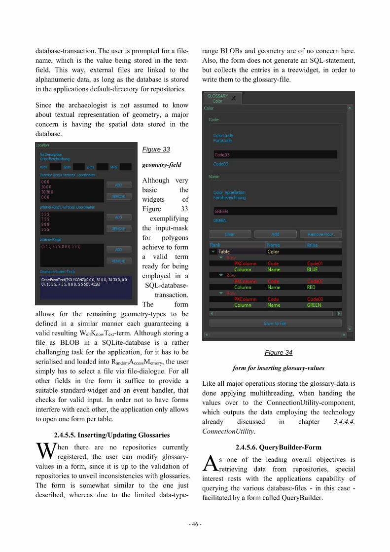
- 46 -
database-transaction. The user is prompted for a file-name, which is the value being stored in the text-field. This way, external files are linked to thealphanumeric data, as long as the database is storedin the applications default-directory for repositories.
Since the archaeologist is not assumed to knowabout textual representation of geometry, a majorconcern is having the spatial data stored in thedatabase.
Figure 33
geometry-field
Although verybasic thewidgets ofFigure 33exemplifying
the input-maskfor polygonsachieve to forma valid termready for beingemployed in aSQL-database-
transaction.The form
allows for the remaining geometry-types to bedefined in a similar manner each guaranteeing avalid resulting WellKnowText-term. Although storing afile as BLOB in a SQLite-database is a ratherchallenging task for the application, for it has to beserialised and loaded into RandomAccessMemory, the usersimply has to select a file via file-dialogue. For allother fields in the form it suffice to provide asuitable standard-widget and an event handler, thatchecks for valid input. In order not to have formsinterfere with each other, the application only allowsto open one form per table.
2.4.5.5. Inserting/Updating Glossaries
hen there are no repositories currentlyregistered, the user can modify glossary-
values in a form, since it is up to the validation ofrepositories to unveil inconsistencies with glossaries.The form is somewhat similar to the one justdescribed, whereas due to the limited data-type-
range BLOBs and geometry are of no concern here.Also, the form does not generate an SQL-statement,but collects the entries in a treewidget, in order towrite them to the glossary-file.
Figure 34
form for inserting glossary-values
Like all major operations storing the glossary-data isdone applying multithreading, when handing thevalues over to the ConnectionUtility-component,which outputs the data employing the technologyalready discussed in chapter 3.4.4.4.ConnectionUtility.
2.4.5.6. QueryBuilder-Form
s one of the leading overall objectives isretrieving data from repositories, special
interest rests with the applications capability ofquerying the various database-files - in this case -facilitated by a form called QueryBuilder.
W A
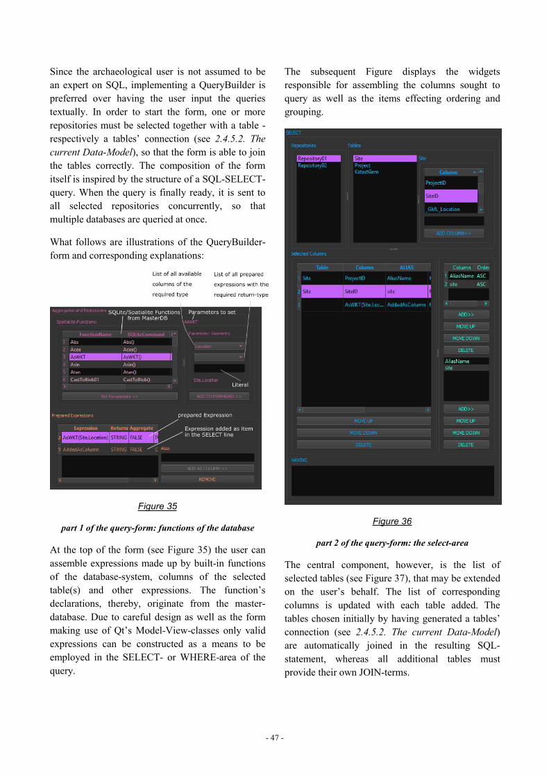
- 47 -
Since the archaeological user is not assumed to bean expert on SQL, implementing a QueryBuilder ispreferred over having the user input the queriestextually. In order to start the form, one or morerepositories must be selected together with a table -respectively a tables’ connection (see 2.4.5.2. Thecurrent Data-Model), so that the form is able to jointhe tables correctly. The composition of the formitself is inspired by the structure of a SQL-SELECT-query. When the query is finally ready, it is sent toall selected repositories concurrently, so thatmultiple databases are queried at once.
What follows are illustrations of the QueryBuilder-form and corresponding explanations:
Figure 35
part 1 of the query-form: functions of the database
At the top of the form (see Figure 35) the user canassemble expressions made up by built-in functionsof the database-system, columns of the selectedtable(s) and other expressions. The function’sdeclarations, thereby, originate from the master-database. Due to careful design as well as the formmaking use of Qt’s Model-View-classes only validexpressions can be constructed as a means to beemployed in the SELECT- or WHERE-area of thequery.
The subsequent Figure displays the widgetsresponsible for assembling the columns sought toquery as well as the items effecting ordering andgrouping.
Figure 36
part 2 of the query-form: the select-area
The central component, however, is the list ofselected tables (see Figure 37), that may be extendedon the user’s behalf. The list of correspondingcolumns is updated with each table added. Thetables chosen initially by having generated a tables’connection (see 2.4.5.2. The current Data-Model)are automatically joined in the resulting SQL-statement, whereas all additional tables mustprovide their own JOIN-terms.
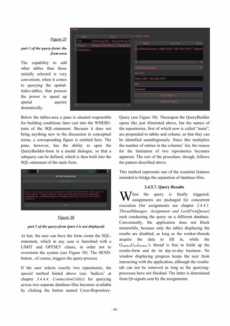
- 48 -
Figure 37
part 3 of the query-form: thefrom-area
The capability to addother tables than thoseinitially selected is veryconvenient, when it comesto querying the spatial-index-tables, that possessthe power to speed upspatial queriesdramatically.
Below the tables-area a pane is situated responsiblefor building conditions later cast into the WHERE-term of the SQL-statement. Because it does notbring anything new to the discussion in conceptualterms, a corresponding figure is omitted here. Thepane, however, has the ability to open theQueryBuilder-form in a modal dialogue, so that asubquery can be defined, which is then built into theSQL-statement of the main form.
Figure 38
part 5 of the query-form (part 4 is not displayed)
At last, the user can have the form create the SQL-statement, which in any case is furnished with aLIMIT and OFFSET clause, in order not tooverstrain the system (see Figure 38). The SEND-button , of course, triggers the query-process.
If the user selects exactly two repositories, thespecial method hinted above (see ‘Indices’ atchapter 3.4.4.4. ConnectionUtility) for queryingacross two separate database-files becomes availableby clicking the button named Cross-Repository-
Query (see Figure 30). Thereupon the QueryBuilderopens like just illustrated above, but the names ofthe repositories, first of which now is called “main”,are prepended to tables and colums, so that they canbe identified unambiguously. Since this multipliesthe number of entries in the columns’ list, the reasonfor the limitation of two repositories becomesapparent. The rest of the procedure, though, followsthe pattern described above.
This method represents one of the essential featuresintended to bridge the separation of database-files.
2.4.5.7. Query Results
hen the query is finally triggered,assignments are packaged for concurrent
execution (for assignments see chapter 2.4.4.1.ThreadManager, Assignment and LockFreeQueue)each conducting the query on a different database.Conveniently, the application does not blockmeanwhile, because only the tables displaying theresults are disabled, as long as the worker-threadsacquire the data to fill in, while theGraphicalUserInterface’s thread is free to build up theresults-form and do its day-to-day business. Nowindow displaying progress keeps the user frominteracting with the application, although the results-tab can not be removed as long as the querying-processes have not finished. The latter is determinedfrom Qt-signals sent by the assignments.
W
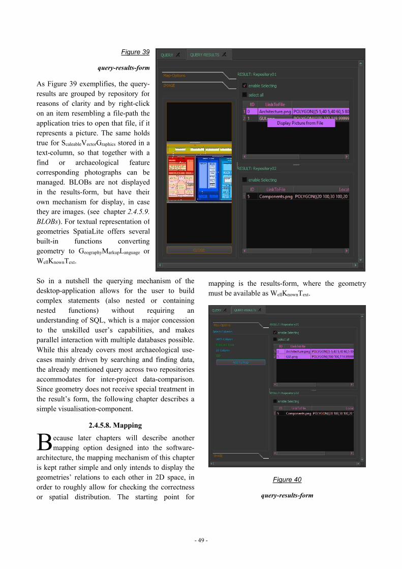
- 49 -
Figure 39
query-results-form
As Figure 39 exemplifies, the query-results are grouped by repository forreasons of clarity and by right-clickon an item resembling a file-path theapplication tries to open that file, if itrepresents a picture. The same holdstrue for ScaleableVectorGraphics stored in atext-column, so that together with afind or archaeological featurecorresponding photographs can bemanaged. BLOBs are not displayedin the results-form, but have theirown mechanism for display, in casethey are images. (see chapter 2.4.5.9.BLOBs). For textual representation ofgeometries SpatiaLite offers severalbuilt-in functions convertinggeometry to GeographyMarkupLanguage orWellKnownText.
So in a nutshell the querying mechanism of thedesktop-application allows for the user to buildcomplex statements (also nested or containingnested functions) without requiring anunderstanding of SQL, which is a major concessionto the unskilled user’s capabilities, and makesparallel interaction with multiple databases possible.While this already covers most archaeological use-cases mainly driven by searching and finding data,the already mentioned query across two repositoriesaccommodates for inter-project data-comparison.Since geometry does not receive special treatment inthe result’s form, the following chapter describes asimple visualisation-component.
2.4.5.8. Mapping
ecause later chapters will describe anothermapping option designed into the software-
architecture, the mapping mechanism of this chapteris kept rather simple and only intends to display thegeometries’ relations to each other in 2D space, inorder to roughly allow for checking the correctnessor spatial distribution. The starting point for
mapping is the results-form, where the geometrymust be available as WellKnownText.
Figure 40
query-results-form
B

- 50 -
After the column-headers of the results-table wereclicked, so as to select the geometries-column aswell as an identifier-column - both essential formapping -, the rows to be illustrated must be marked,before finally the AddToMap-button can be clickedsending the geometries to the mapping-surface,where the spatial information is extracted from theWellKnownText format, in order to create the graphic-items.
Purpose and Preconditions
Figure 41
mapping surface featuring map, navigation window andlayer-control using Qt’s 2D graphics
The mapping device features not only the actualmap, a little navigator, a dynamically adaptingscale-bar and a list of layers holding the geometries,but also responds to interactions such as panning orzooming on mouse-wheel-events, since according tothe user’s expectations stipulated by all sorts ofweb-maps an intuitive handling is aspired. Of course,the layer as well as the single geometry allow for thevarious visual attributes, such as colour or opacity,to be manipulated via context menu, whilefurthermore the listed item is interrelated with themapped geometry thus enabling the user to find theone by selecting the other.
It has to be stressed, however, that the mapping-pane does not intend to be or replace a fully fledgeddesktop-GeographicalInformationSystem like QGIS72 and doesnot account for reference-systems or projections,because the geometry coming in any case fromquery-results can easily be projected in the course ofthe query using SpatiaLite’s built-in functions.73This guarantees the freedom to map even geometriescreated on the fly by the query. Although on the onehand there is a Qt-module dealing with maps74 andon the other hand QGIS libraries operating on theQt-framework also appear applicable for building amap, both options are unfit to leverage geometry-display here, because Qt’s library is not availablefor C++ (only QML) and QGIS until now relies onthe (old) Qt4 libraries thence resulting inincompatibilities. Besides, QGIS’ map-visualisationhardly surpasses Qt’s default 2D-graphicscapabilities exemplified at Figure 41.
Implementation
From a programmer’s technical viewpoint even thebasic mapping and map-handling of Figure 41demand more sophisticated coding than non-graphic-related widgets do, not to mention thechallenges accompanying multi-threading. As soonas the essential issues on how to represent ormanage the spatial features and how to handle user-interaction are solved, getting the geometry onto themap, however, is comparatively straightforward.
The main widget inheriting from QSplitter75manages all interplay between thegeometries/layers-list, the buttons and the display ofgraphics. While the layers’ list actually is a simpleQTreeView76 operating on a QStandardItemModel77,
72 Although QGIS is capable of loading geometry right from theSpatiaLite-database (see for example:http://docs.qgis.org/2.0/de/docs/training_manual/databases/spatialite.html <last visited: 09.03.2017>), it appears that it can onlyload the full count of a table’s entries leading towardsperformance penalty or program-crash when big-data isconcerned. A more scalable approach is thus attempted here.73 see: http://doc.qt.io/qt-5/qsplitter.html <last visited:09.03.2017>.74 see: http://doc.qt.io/qt-5/location-maps-cpp.html <last visited:09.03.2017>.75 see: http://doc.qt.io/qt-5/qsplitter.html <last visited:09.03.2017>.76 see: http://doc.qt.io/qt-5/qtreeview.html <last visited:09.03.2017>.
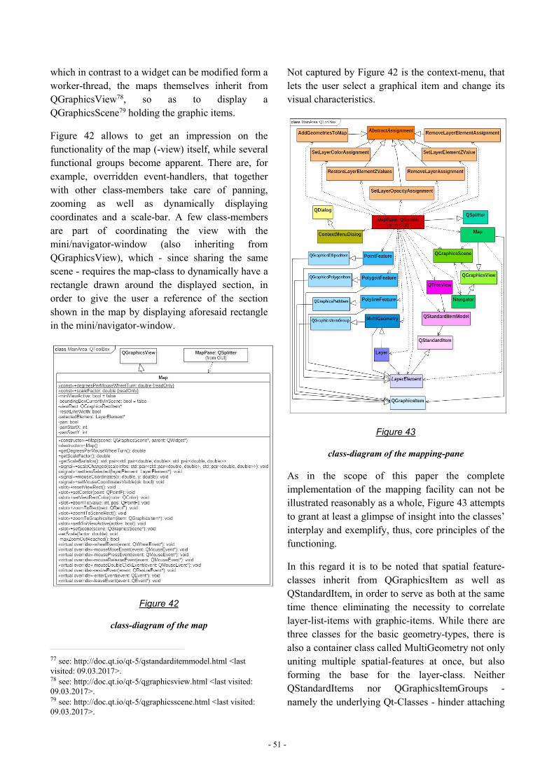
- 51 -
which in contrast to a widget can be modified form aworker-thread, the maps themselves inherit fromQGraphicsView78, so as to display aQGraphicsScene79 holding the graphic items.
Figure 42 allows to get an impression on thefunctionality of the map (-view) itself, while severalfunctional groups become apparent. There are, forexample, overridden event-handlers, that togetherwith other class-members take care of panning,zooming as well as dynamically displayingcoordinates and a scale-bar. A few class-membersare part of coordinating the view with themini/navigator-window (also inheriting fromQGraphicsView), which - since sharing the samescene - requires the map-class to dynamically have arectangle drawn around the displayed section, inorder to give the user a reference of the sectionshown in the map by displaying aforesaid rectanglein the mini/navigator-window.
Figure 42
class-diagram of the map
77 see: http://doc.qt.io/qt-5/qstandarditemmodel.html <lastvisited: 09.03.2017>.78 see: http://doc.qt.io/qt-5/qgraphicsview.html <last visited:09.03.2017>.79 see: http://doc.qt.io/qt-5/qgraphicsscene.html <last visited:09.03.2017>.
Not captured by Figure 42 is the context-menu, thatlets the user select a graphical item and change itsvisual characteristics.
Figure 43
class-diagram of the mapping-pane
As in the scope of this paper the completeimplementation of the mapping facility can not beillustrated reasonably as a whole, Figure 43 attemptsto grant at least a glimpse of insight into the classes’interplay and exemplify, thus, core principles of thefunctioning.
In this regard it is to be noted that spatial feature-classes inherit from QGraphicsItem as well asQStandardItem, in order to serve as both at the sametime thence eliminating the necessity to correlatelayer-list-items with graphic-items. While there arethree classes for the basic geometry-types, there isalso a container class called MultiGeometry not onlyuniting multiple spatial-features at once, but alsoforming the base for the layer-class. NeitherQStandardItems nor QGraphicsItemGroups -namely the underlying Qt-Classes - hinder attaching
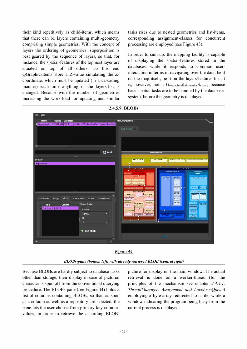
- 52 -
their kind repetitively as child-items, which meansthat there can be layers containing multi-geometrycomprising simple geometries. With the concept oflayers the ordering of geometries’ superposition isbest geared by the sequence of layers, so that, forinstance, the spatial-features of the topmost layer aresituated on top of all others. To this endQGraphicsItems store a Z-value simulating the Z-coordinate, which must be updated (in a cascadingmanner) each time anything in the layers-list ischanged. Because with the number of geometriesincreasing the work-load for updating and similar
tasks rises due to nested geometries and list-items,corresponding assignment-classes for concurrentprocessing are employed (see Figure 43).
In order to sum up: the mapping facility is capableof displaying the spatial-features stored in thedatabases, while it responds to common user-interaction in terms of navigating over the data, be iton the map itself, be it on the layers/features-list. Itis, however, not a GeographicalInformationSystem, becausebasic spatial tasks are to be handled by the database-system, before the geometry is displayed.
2.4.5.9. BLOBs
Figure 44
BLOBs-pane (bottom left) with already retrieved BLOB (central right)
Because BLOBs are hardly subject to database-tasksother than storage, their display in case of pictorialcharacter is spun off from the conventional queryingprocedure. The BLOBs pane (see Figure 44) holds alist of columns containing BLOBs, so that, as soonas a column as well as a repository are selected, thepane lets the user choose from primary-key-column-values, in order to retrieve the according BLOB-
picture for display on the main-window. The actualretrieval is done on a worker-thread (for theprinciples of the mechanism see chapter 2.4.4.1.ThreadManager, Assignment and LockFreeQueue)employing a byte-array redirected to a file, while awindow indicating the program being busy from thecurrent process is displayed.
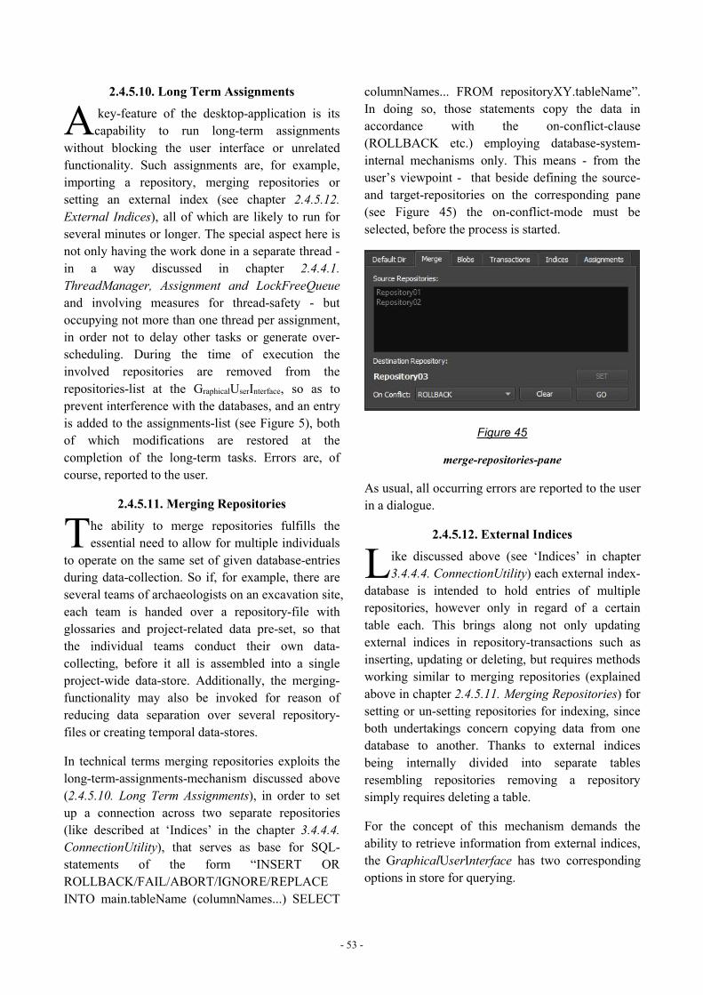
- 53 -
2.4.5.10. Long Term Assignments
key-feature of the desktop-application is itscapability to run long-term assignments
without blocking the user interface or unrelatedfunctionality. Such assignments are, for example,importing a repository, merging repositories orsetting an external index (see chapter 2.4.5.12.External Indices), all of which are likely to run forseveral minutes or longer. The special aspect here isnot only having the work done in a separate thread -in a way discussed in chapter 2.4.4.1.ThreadManager, Assignment and LockFreeQueueand involving measures for thread-safety - butoccupying not more than one thread per assignment,in order not to delay other tasks or generate over-scheduling. During the time of execution theinvolved repositories are removed from therepositories-list at the GraphicalUserInterface, so as toprevent interference with the databases, and an entryis added to the assignments-list (see Figure 5), bothof which modifications are restored at thecompletion of the long-term tasks. Errors are, ofcourse, reported to the user.
2.4.5.11. Merging Repositories
he ability to merge repositories fulfills theessential need to allow for multiple individuals
to operate on the same set of given database-entriesduring data-collection. So if, for example, there areseveral teams of archaeologists on an excavation site,each team is handed over a repository-file withglossaries and project-related data pre-set, so thatthe individual teams conduct their own data-collecting, before it all is assembled into a singleproject-wide data-store. Additionally, the merging-functionality may also be invoked for reason ofreducing data separation over several repository-files or creating temporal data-stores.
In technical terms merging repositories exploits thelong-term-assignments-mechanism discussed above(2.4.5.10. Long Term Assignments), in order to setup a connection across two separate repositories(like described at ‘Indices’ in the chapter 3.4.4.4.ConnectionUtility), that serves as base for SQL-statements of the form “INSERT ORROLLBACK/FAIL/ABORT/IGNORE/REPLACEINTO main.tableName (columnNames...) SELECT
columnNames... FROM repositoryXY.tableName”.In doing so, those statements copy the data inaccordance with the on-conflict-clause(ROLLBACK etc.) employing database-system-internal mechanisms only. This means - from theuser’s viewpoint - that beside defining the source-and target-repositories on the corresponding pane(see Figure 45) the on-conflict-mode must beselected, before the process is started.
Figure 45
merge-repositories-pane
As usual, all occurring errors are reported to the userin a dialogue.
2.4.5.12. External Indices
ike discussed above (see ‘Indices’ in chapter3.4.4.4. ConnectionUtility) each external index-
database is intended to hold entries of multiplerepositories, however only in regard of a certaintable each. This brings along not only updatingexternal indices in repository-transactions such asinserting, updating or deleting, but requires methodsworking similar to merging repositories (explainedabove in chapter 2.4.5.11. Merging Repositories) forsetting or un-setting repositories for indexing, sinceboth undertakings concern copying data from onedatabase to another. Thanks to external indicesbeing internally divided into separate tablesresembling repositories removing a repositorysimply requires deleting a table.
For the concept of this mechanism demands theability to retrieve information from external indices,the GraphicalUserInterface has two correspondingoptions in store for querying.
A
TL
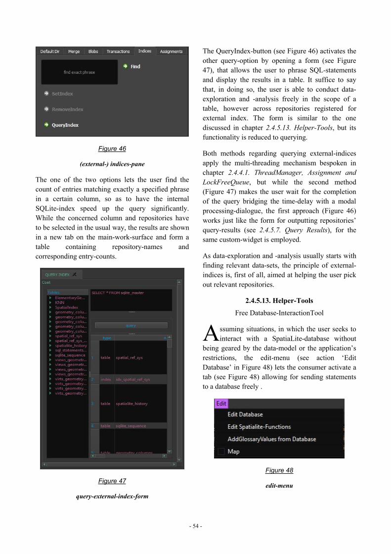
- 54 -
Figure 46
(external-) indices-pane
The one of the two options lets the user find thecount of entries matching exactly a specified phrasein a certain column, so as to have the internalSQLite-index speed up the query significantly.While the concerned column and repositories haveto be selected in the usual way, the results are shownin a new tab on the main-work-surface and form atable containing repository-names andcorresponding entry-counts.
Figure 47
query-external-index-form
The QueryIndex-button (see Figure 46) activates theother query-option by opening a form (see Figure47), that allows the user to phrase SQL-statementsand display the results in a table. It suffice to saythat, in doing so, the user is able to conduct data-exploration and -analysis freely in the scope of atable, however across repositories registered forexternal index. The form is similar to the onediscussed in chapter 2.4.5.13. Helper-Tools, but itsfunctionality is reduced to querying.
Both methods regarding querying external-indicesapply the multi-threading mechanism bespoken inchapter 2.4.4.1. ThreadManager, Assignment andLockFreeQueue, but while the second method(Figure 47) makes the user wait for the completionof the query bridging the time-delay with a modalprocessing-dialogue, the first approach (Figure 46)works just like the form for outputting repositories’query-results (see 2.4.5.7. Query Results), for thesame custom-widget is employed.
As data-exploration and -analysis usually starts withfinding relevant data-sets, the principle of external-indices is, first of all, aimed at helping the user pickout relevant repositories.
2.4.5.13. Helper-Tools
Free Database-InteractionTool
ssuming situations, in which the user seeks tointeract with a SpatiaLite-database without
being geared by the data-model or the application’srestrictions, the edit-menu (see action ‘EditDatabase’ in Figure 48) lets the consumer activate atab (see Figure 48) allowing for sending statementsto a database freely .
Figure 48
edit-menu
A
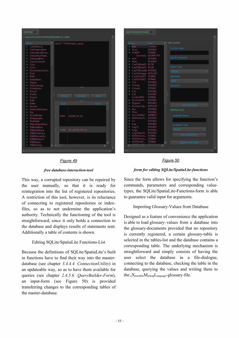
- 55 -
Figure 49
free database-interaction-tool
This way, a corrupted repository can be repaired bythe user manually, so that it is ready forreintegration into the list of registered repositories.A restriction of this tool, however, is its reluctanceof connecting to registered repositories or index-files, so as to not undermine the application’sauthority. Technically the functioning of the tool isstraightforward, since it only holds a connection tothe database and displays results of statements sent.Additionally a table of contents is shown.
Editing SQLite/SpatiaLite Functions-List
Because the definitions of SQLite/SpatiaLite’s builtin functions have to find their way into the master-database (see chapter 3.4.4.4. ConnectionUtility) inan updateable way, so as to have them available forqueries (see chapter 2.4.5.6. QueryBuilder-Form),an input-form (see Figure 50) is providedtransferring changes to the corresponding tables ofthe master-database.
Figure 50
form for editing SQLite/SpatiaLite-functions
Since the form allows for specifying the function’scommands, parameters and corresponding value-types, the SQLite/SpatiaLite-Functions-form is ableto guarantee valid input for arguments.
Importing Glossary-Values from Database
Designed as a feature of convenience the applicationis able to load glossary- values from a database intothe glossary-documents provided that no repositoryis currently registered, a certain glossary-table isselected in the tables-list and the database contains acorresponding table. The underlying mechanism isstraightforward and simply consists of having theuser select the database in a file-dialogue,connecting to the database, checking the table in thedatabase, querying the values and writing them tothe eXtensibleMarkupLanguage-glossary-file.
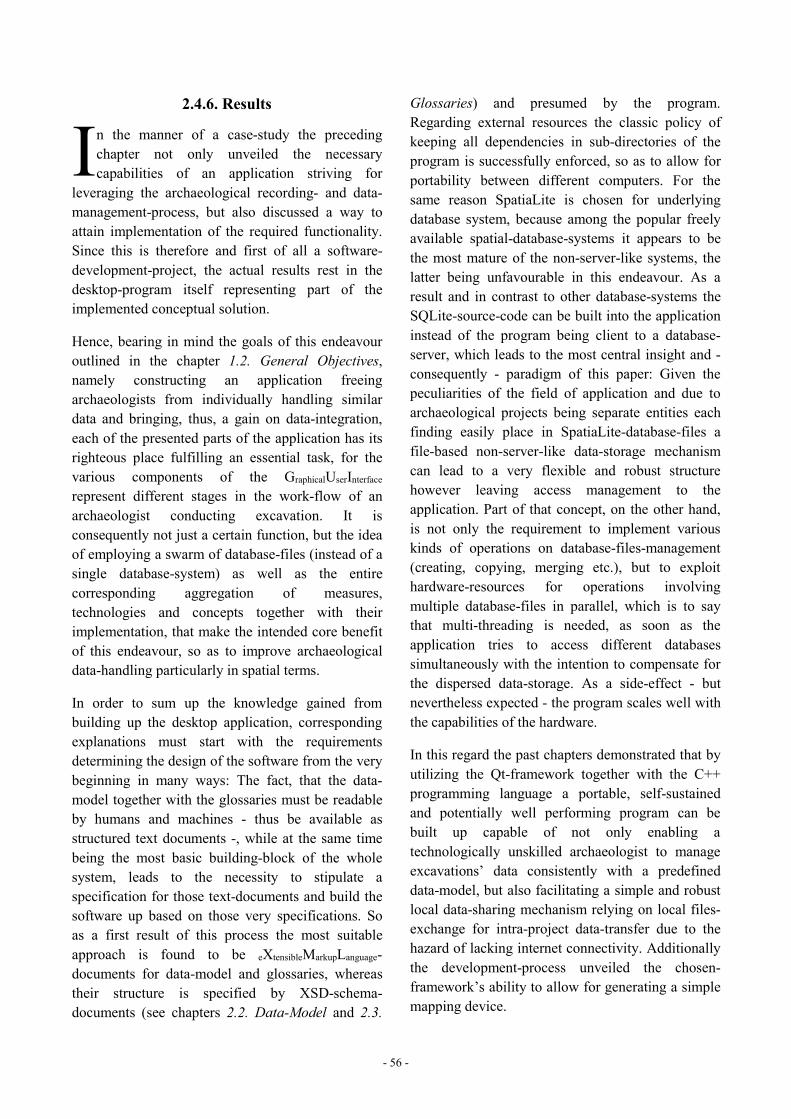
- 56 -
2.4.6. Results
n the manner of a case-study the precedingchapter not only unveiled the necessarycapabilities of an application striving for
leveraging the archaeological recording- and data-management-process, but also discussed a way toattain implementation of the required functionality.Since this is therefore and first of all a software-development-project, the actual results rest in thedesktop-program itself representing part of theimplemented conceptual solution.
Hence, bearing in mind the goals of this endeavouroutlined in the chapter 1.2. General Objectives,namely constructing an application freeingarchaeologists from individually handling similardata and bringing, thus, a gain on data-integration,each of the presented parts of the application has itsrighteous place fulfilling an essential task, for thevarious components of the GraphicalUserInterfacerepresent different stages in the work-flow of anarchaeologist conducting excavation. It isconsequently not just a certain function, but the ideaof employing a swarm of database-files (instead of asingle database-system) as well as the entirecorresponding aggregation of measures,technologies and concepts together with theirimplementation, that make the intended core benefitof this endeavour, so as to improve archaeologicaldata-handling particularly in spatial terms.
In order to sum up the knowledge gained frombuilding up the desktop application, correspondingexplanations must start with the requirementsdetermining the design of the software from the verybeginning in many ways: The fact, that the data-model together with the glossaries must be readableby humans and machines - thus be available asstructured text documents -, while at the same timebeing the most basic building-block of the wholesystem, leads to the necessity to stipulate aspecification for those text-documents and build thesoftware up based on those very specifications. Soas a first result of this process the most suitableapproach is found to be eXtensibleMarkupLanguage-documents for data-model and glossaries, whereastheir structure is specified by XSD-schema-documents (see chapters 2.2. Data-Model and 2.3.
Glossaries) and presumed by the program.Regarding external resources the classic policy ofkeeping all dependencies in sub-directories of theprogram is successfully enforced, so as to allow forportability between different computers. For thesame reason SpatiaLite is chosen for underlyingdatabase system, because among the popular freelyavailable spatial-database-systems it appears to bethe most mature of the non-server-like systems, thelatter being unfavourable in this endeavour. As aresult and in contrast to other database-systems theSQLite-source-code can be built into the applicationinstead of the program being client to a database-server, which leads to the most central insight and -consequently - paradigm of this paper: Given thepeculiarities of the field of application and due toarchaeological projects being separate entities eachfinding easily place in SpatiaLite-database-files afile-based non-server-like data-storage mechanismcan lead to a very flexible and robust structurehowever leaving access management to theapplication. Part of that concept, on the other hand,is not only the requirement to implement variouskinds of operations on database-files-management(creating, copying, merging etc.), but to exploithardware-resources for operations involvingmultiple database-files in parallel, which is to saythat multi-threading is needed, as soon as theapplication tries to access different databasessimultaneously with the intention to compensate forthe dispersed data-storage. As a side-effect - butnevertheless expected - the program scales well withthe capabilities of the hardware.
In this regard the past chapters demonstrated that byutilizing the Qt-framework together with the C++programming language a portable, self-sustainedand potentially well performing program can bebuilt up capable of not only enabling atechnologically unskilled archaeologist to manageexcavations’ data consistently with a predefineddata-model, but also facilitating a simple and robustlocal data-sharing mechanism relying on local files-exchange for intra-project data-transfer due to thehazard of lacking internet connectivity. Additionallythe development-process unveiled the chosen-framework’s ability to allow for generating a simplemapping device.
I
- 57 -
Prospects
Because the application is already comparativelyextensive in its core-functionality, theimplementation of some rather specific features isleft to future attempts, one of which being supplyingthe implemented map with support for shapefile-and geotiff-import. Since in the course of publishingdata the following chapters will introduce othermapping tools and because the application does notintend to be a GeographicInformationSystem - as said before -,
the desktop-program does not yet take advantage ofQt’s support80 of OpenGL81, in order to facilitate 3Dvisualization. Although the latter, too, is probably abeneficial objective for future projects, the websitediscussed in the following chapters already makesuse of a similar technology named WebGL82
anyway, so that the utilization and benefits of thiskind of graphics-library is demonstrated here in anycase. Beside that, other endeavours may also attemptto exploit SQLite’s full capacity, of which only thecore-functionality made it into the application yet.
80 see: http://doc.qt.io/qt-5/qtgui-index.html <last visited:15.03.2017>.81 see: https://www.opengl.org/ <last visited: 15.03.2017>.82 see for example: Anyuru 2012.
- 58 -
2.5. PUBLISHING THE DATAhereas the past chapter presented asolution for on-site archaeologicaldata-management covering merelyorganizational concerns of an
excavation-project, this chapter deals with makingthe data available outside the project’s scope vianetwork (internet).
The basic idea is to host a website entrusted withconveying an impression of the data associated witheach data-model, so as to help the remote userdecide, which data to obtain. While the resultingdata-transfer in this case is achieved simply bydownloads as well as WebFeatureService - the latterrepresenting an acknowledged standard after all -,the website itself serves both, the remote and thelocal user.
Like hinted by Figure 1 and Figure 2, the maincomponents on the server-side are the server itself, ascript-interpreter, a script-library for accessing thedatabase-files as well as server-side scripts, whilethe client is sent an HTML-document holding thebasic information together with JavaScript-scriptsand style-information codified as CascadingStyleSheet. Soirrespective of dynamically assembled documentssuch as certain download-files and the WebFeatureServicthe following pages deal with selecting a suitableserver together with a server-side scripting language,before the websites functionality is discussed.
2.5.1. Server-Side-Scripting
ince dynamic websites necessitate some kindof server-side scripting, the most essentialquestion in terms of web-technologies centers
upon the scripting-language required to supportconnections to the SQLite-database-system. Amongthe various language-bindings of SQLite83 mainlythree languages appear suitable for server-side tasks,namely Ruby, Python and PHP, the latter of whichbeing obviously the only language specialized inserver-side scripting [Tatroe and others 2013]. SincePHP not only provides classes for interaction withSQLite as part of its standard-library [Tatroe and
83 see for example Owens 2006 orhttps://en.wikipedia.org/wiki/SQLite <last visited: 16.03.2017>.
others 2013; Owens 2006;http://www.php.net/manual/de/class.sqlite3.php<last visited: 16.03.2017>], but also occupies by farthe greatest share of the marked [Tatroe and others2013; https://w3techs.com/technologies/overview/programming_language/all <last visited:16.03.2017>] indicating an active community aswell as good support, PHP is the best choice forserver-side-scripting in the course of this endeavour.
2.5.2. The Server
ortunately, when it comes to http-servers, onecan resort so several free and ready-to-usesolutions available via download. Besides
simply serving HTML-documents a server is - inthis undertaking- required to be applicable on thethree main operating systems, as much portable aspossible, ready to generate dynamic content (viaPHP-scripts) and have good performance. As itappears, the currently most popular http-serverscovering the largest part of the market and fulfillingthe requirements are Apache-HTTP-Server andNGINX [https://opensource.com/business/16/8/top-5-open-source-web-servers <last visited:16.03.2017>; https://w3techs.com/technologies/overview/web_server/all <last visited: 16.03.2017>].Accepted that the applied server is to be recruitedfrom those two options - as this paper aims atexemplifying procedures on prevalent technologies -,in terms of performance and footprint (on the system)[Nedelcu 2013] NGINX is in favour.
Because information on how to have NGINXprepared for serving dynamic websites - respectivelysetting up CommonGatewayInterface with PHP - isprovided elsewhere [see Nedelcu 2013 orhttps://www.nginx.com/resources/wiki/start/topics/examples/phpfastcgionwindows/ <last visited:16.03.2017>], the according specifications are not tobe repeated here in detail, but it suffice to say thaton the one hand the PHP-CGI-executable must beactivated listening to the specified port, while on theother hand NGINX must be aware of those veryconnection-parameters codified in the server’sconfiguration-file.
W
S
F
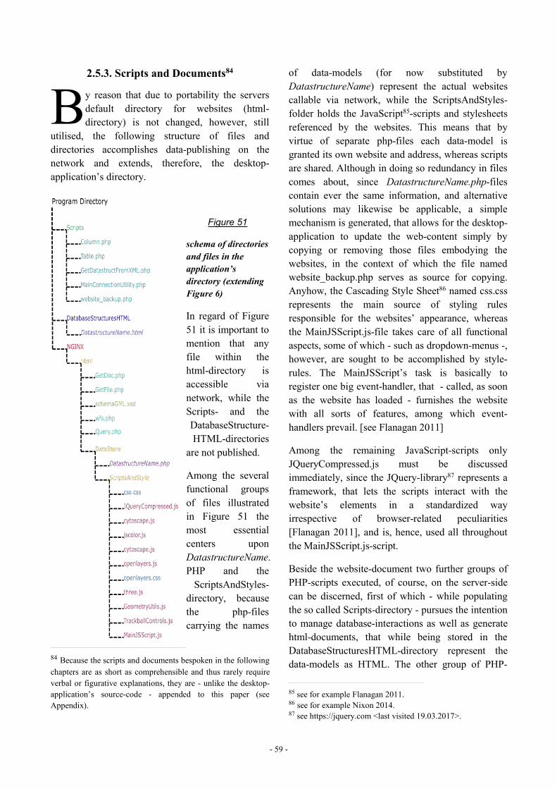
- 59 -
2.5.3. Scripts and Documents84
y reason that due to portability the serversdefault directory for websites (html-directory) is not changed, however, still
utilised, the following structure of files anddirectories accomplishes data-publishing on thenetwork and extends, therefore, the desktop-application’s directory.
Figure 51
schema of directoriesand files in theapplication’sdirectory (extendingFigure 6)
In regard of Figure51 it is important tomention that anyfile within thehtml-directory isaccessible vianetwork, while theScripts- and theDatabaseStructure-HTML-directories
are not published.
Among the severalfunctional groupsof files illustratedin Figure 51 themost essentialcenters uponDatastructureName.PHP and theScriptsAndStyles-
directory, becausethe php-filescarrying the names
84 Because the scripts and documents bespoken in the followingchapters are as short as comprehensible and thus rarely requireverbal or figurative explanations, they are - unlike the desktop-application’s source-code - appended to this paper (seeAppendix).
of data-models (for now substituted byDatastructureName) represent the actual websitescallable via network, while the ScriptsAndStyles-folder holds the JavaScript85-scripts and stylesheetsreferenced by the websites. This means that byvirtue of separate php-files each data-model isgranted its own website and address, whereas scriptsare shared. Although in doing so redundancy in filescomes about, since DatastructureName.php-filescontain ever the same information, and alternativesolutions may likewise be applicable, a simplemechanism is generated, that allows for the desktop-application to update the web-content simply bycopying or removing those files embodying thewebsites, in the context of which the file namedwebsite_backup.php serves as source for copying.Anyhow, the Cascading Style Sheet86 named css.cssrepresents the main source of styling rulesresponsible for the websites’ appearance, whereasthe MainJSScript.js-file takes care of all functionalaspects, some of which - such as dropdown-menus -,however, are sought to be accomplished by style-rules. The MainJSScript’s task is basically toregister one big event-handler, that - called, as soonas the website has loaded - furnishes the websitewith all sorts of features, among which event-handlers prevail. [see Flanagan 2011]
Among the remaining JavaScript-scripts onlyJQueryCompressed.js must be discussedimmediately, since the JQuery-library87 represents aframework, that lets the scripts interact with thewebsite’s elements in a standardized wayirrespective of browser-related peculiarities[Flanagan 2011], and is, hence, used all throughoutthe MainJSScript.js-script.
Beside the website-document two further groups ofPHP-scripts executed, of course, on the server-sidecan be discerned, first of which - while populatingthe so called Scripts-directory - pursues the intentionto manage database-interactions as well as generatehtml-documents, that while being stored in theDatabaseStructuresHTML-directory represent thedata-models as HTML. The other group of PHP-
85 see for example Flanagan 2011.86 see for example Nixon 2014.87 see https://jquery.com <last visited 19.03.2017>.
B
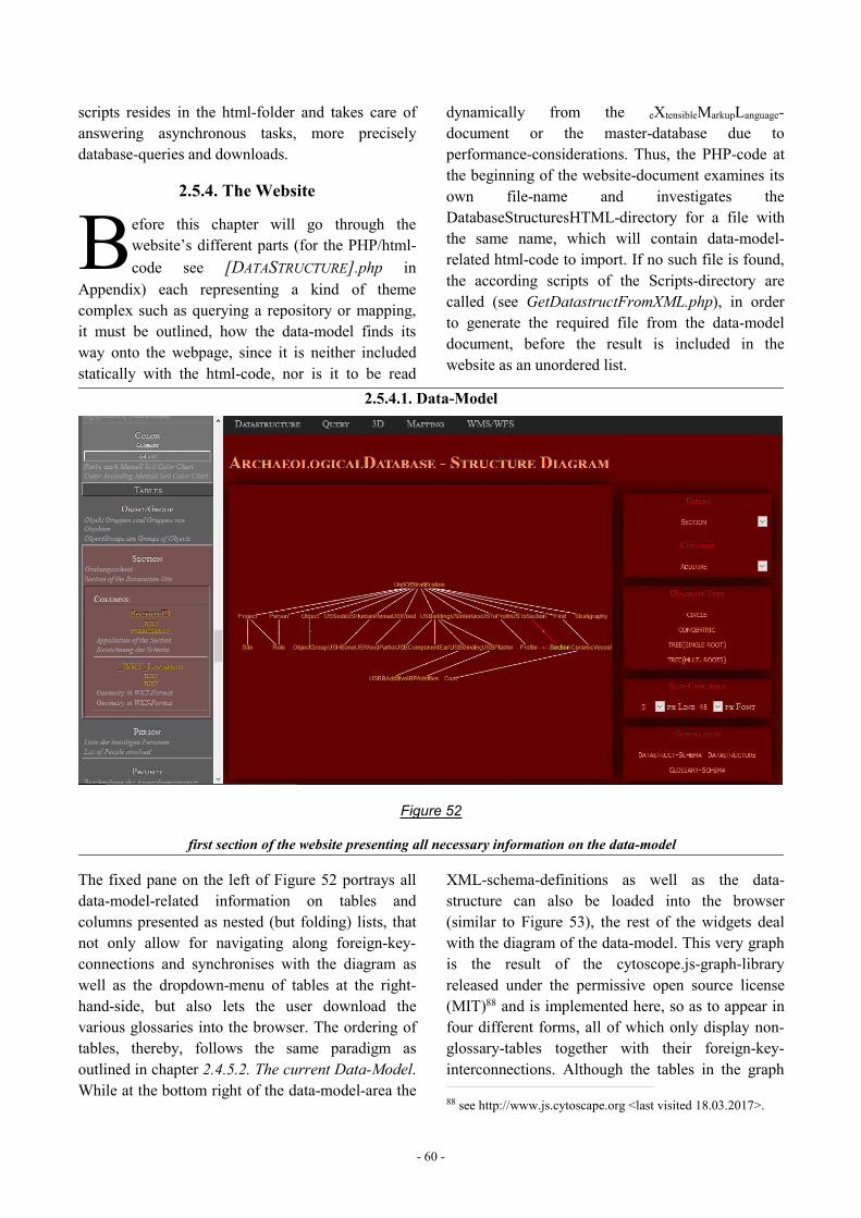
- 60 -
scripts resides in the html-folder and takes care ofanswering asynchronous tasks, more preciselydatabase-queries and downloads.
2.5.4. The Website
efore this chapter will go through thewebsite’s different parts (for the PHP/html-code see [DATASTRUCTURE].php in
Appendix) each representing a kind of themecomplex such as querying a repository or mapping,it must be outlined, how the data-model finds itsway onto the webpage, since it is neither includedstatically with the html-code, nor is it to be read
dynamically from the eXtensibleMarkupLanguage-document or the master-database due toperformance-considerations. Thus, the PHP-code atthe beginning of the website-document examines itsown file-name and investigates theDatabaseStructuresHTML-directory for a file withthe same name, which will contain data-model-related html-code to import. If no such file is found,the according scripts of the Scripts-directory arecalled (see GetDatastructFromXML.php), in orderto generate the required file from the data-modeldocument, before the result is included in thewebsite as an unordered list.
2.5.4.1. Data-Model
Figure 52
first section of the website presenting all necessary information on the data-model
The fixed pane on the left of Figure 52 portrays alldata-model-related information on tables andcolumns presented as nested (but folding) lists, thatnot only allow for navigating along foreign-key-connections and synchronises with the diagram aswell as the dropdown-menu of tables at the right-hand-side, but also lets the user download thevarious glossaries into the browser. The ordering oftables, thereby, follows the same paradigm asoutlined in chapter 2.4.5.2. The current Data-Model.While at the bottom right of the data-model-area the
XML-schema-definitions as well as the data-structure can also be loaded into the browser(similar to Figure 53), the rest of the widgets dealwith the diagram of the data-model. This very graphis the result of the cytoscope.js-graph-libraryreleased under the permissive open source license(MIT)88 and is implemented here, so as to appear infour different forms, all of which only display non-glossary-tables together with their foreign-key-interconnections. Although the tables in the graph
88 see http://www.js.cytoscape.org <last visited 18.03.2017>.
B
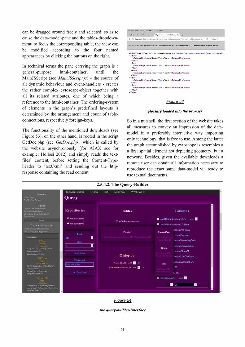
- 61 -
can be dragged around freely and selected, so as tocause the data-model-pane and the tables-dropdown-menu to focus the corresponding table, the view canbe modified according to the four namedappearances by clicking the buttons on the right.
In technical terms the pane carrying the graph is ageneral-purpose html-container, until theMainJSScript (see MainJSScript.js) - the source ofall dynamic behaviour and event-handlers - createsthe rather complex cytoscape-object together withall its related attributes, one of which being areference to the html-container. The ordering-systemof elements in the graph’s predefined layouts isdetermined by the arrangement and count of table-connections, respectively foreign-keys.
The functionality of the mentioned downloads (seeFigure 53), on the other hand, is rooted in the scriptGetDoc.php (see GetDoc.php), which is called bythe website asynchronously [for AJAX see forexample: Hollosi 2012] and simply reads the text-files’ content, before setting the Content-Type-header to ‘text/xml’ and sending out the http-response containing the read content.
Figure 53
glossary loaded into the browser
So in a nutshell, the first section of the website takesall measures to convey an impression of the data-model in a preferably interactive way importingonly technology, that is free to use. Among the latterthe graph accomplished by cytoscope.js resembles aa first spatial element not depicting geometry, but anetwork. Besides, given the available downloads aremote user can obtain all information necessary toreproduce the exact same data-model via ready touse textual documents.
2.5.4.2. The Query-Builder
Figure 54
the query-builder-interface

- 62 -
he query-builder - although simple - fulfillsnevertheless a task similar to the desktop-
application’s query-mechanism, namely enablingthe user to browse through the repositories’ datawithout requiring an understanding of SQL.
The query begins with the table currently selected inthe tables’ dropdown-menu (see Figure 52), whereasfurther tables can only be added by clicking thechosen table’s sub-menu-items representing relatedtables (see Figure 54). This way, a chain ofinterconnected tables is produced taking care ofadding each table to the query only once. As a result,the query-builder offers only the columnsoriginating from the chosen tables, so as to havethem selected by the user, be it for normal query, beit for aggregate function or as part of a simplecondition. Related ORDER BY- or GROUP BY-clauses are filled automatically, in order to have theuser only decide, which columns to exclude fromordering or grouping again.
Because in its intention to be as dynamic asinteracted with intuitively the query-builder watchesover the user’s input, it completely eliminates therisk of assembling a syntactically invalid SQL-query.The information on the data-model is gathered fromthe html-elements forming the fixed pane at the leftand made into a dynamic form applying JavaScript.Aside from selecting the repository sought to queryand specifying the limit as well as offset of theresulting datasets, the pane for downloads is to benoticed in Figure 54, since it enables the user todownload either a copy of the repository (when nofile-name is specified) or download a certain filereferenced by the repository. The second option isonly then successful, if the repository is situated inthe default-repository and has the requested filestored in its external files-directory.
Before the following chapter will finally outline theresult of clicking the Send-Query-button, the waythe query-builder works is to be discussed. Sincepreparing PHP for loading extensions to SQLiteturned out to be a cumbersome procedure - whilstthe spatial functionality of SpatiaLite is actually notneeded for simple data-requests and may even leadto performance-penalty -, an alternative solution isestablished requiring the desktop-application to
install two further columns with each spatial-column.Those two other fields hold representations of theaccording geometry in the form of WellKnownText aswell as GeographyMarkupLanguage and are updated bytriggers, so as to jump one process in the course of aquery and output the geometry’s textualrepresentation directly. The website respects thatfact in a way, as it offers only the column’s textual-version for query. As far as the actual process ofquerying is concerned, the according event-handlertriggered by the Send-Query-button collects theinformation and assembles it into a http-requestutilizing the POST-Method89, before the request issent asynchronously to the server. Another event-handler (see MainJSScript.js) is, of course,registered, so as to receive the response generatedby the script Query.php (see Query.php), that - in anutshell - checks the transferred SQL-parts viaregular-expressions, seeks out the file-path to therepository from the master-database, connects to andqueries the latter, before the results are returned inthe form of html.
Another asynchronous task is the files-downloadinvolving the script GetFile.php (see GetFile.php),which basically finds the requested file and reads itto the output, in which process setting the necessaryresponse-headers is crucial, since they make thebrowser initiate its download-proceeding as shownin Figure 55.
Figure 55
download-dialog
So all in all,the ideabehind theQuery-areais to equip
the user with a rudimentary, but easy to usemechanism to retrieve data from repositories, inorder to convey a rough impression of therepositories’ content. The functionality is notexhaustive, since advanced tasks are supposed to beexecuted in full-blown GeographicInformationSystems afterobtaining the data via WebFeatureService or files-
89 see for example Flanagan 2011.
T
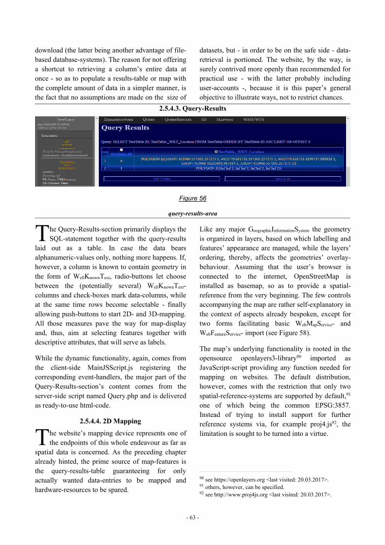
- 63 -
download (the latter being another advantage of file-based database-systems). The reason for not offeringa shortcut to retrieving a column’s entire data atonce - so as to populate a results-table or map withthe complete amount of data in a simpler manner, isthe fact that no assumptions are made on the size of
datasets, but - in order to be on the safe side - data-retrieval is portioned. The website, by the way, issurely contrived more openly than recommended forpractical use - with the latter probably includinguser-accounts -, because it is this paper’s generalobjective to illustrate ways, not to restrict chances.
2.5.4.3. Query-Results
Figure 56
query-results-area
he Query-Results-section primarily displays theSQL-statement together with the query-results
laid out as a table. In case the data bearsalphanumeric-values only, nothing more happens. If,however, a column is known to contain geometry inthe form of WellKnownText, radio-buttons let choosebetween the (potentially several) WellKnownText-columns and check-boxes mark data-columns, whileat the same time rows become selectable - finallyallowing push-buttons to start 2D- and 3D-mapping.All those measures pave the way for map-displayand, thus, aim at selecting features together withdescriptive attributes, that will serve as labels.
While the dynamic functionality, again, comes fromthe client-side MainJSScript.js registering thecorresponding event-handlers, the major part of theQuery-Results-section’s content comes from theserver-side script named Query.php and is deliveredas ready-to-use html-code.
2.5.4.4. 2D Mapping
he website’s mapping device represents one ofthe endpoints of this whole endeavour as far as
spatial data is concerned. As the preceding chapteralready hinted, the prime source of map-features isthe query-results-table guaranteeing for onlyactually wanted data-entries to be mapped andhardware-resources to be spared.
Like any major GeographicInformationSystem the geometryis organized in layers, based on which labelling andfeatures’ appearance are managed, while the layers’ordering, thereby, affects the geometries’ overlay-behaviour. Assuming that the user’s browser isconnected to the internet, OpenStreetMap isinstalled as basemap, so as to provide a spatial-reference from the very beginning. The few controlsaccompanying the map are rather self-explanatory inthe context of aspects already bespoken, except fortwo forms facilitating basic WebMapService- andWebFeatureService- import (see Figure 58).
The map’s underlying functionality is rooted in theopensource openlayers3-library90 imported asJavaScript-script providing any function needed formapping on websites. The default distribution,however, comes with the restriction that only twospatial-reference-systems are supported by default,91one of which being the common EPSG:3857.Instead of trying to install support for furtherreference systems via, for example proj4.js92, thelimitation is sought to be turned into a virtue.
90 see https://openlayers.org <last visited: 20.03.2017>.91 others, however, can be specified.92 see http://www.proj4js.org <last visited: 20.03.2017>.
T
T
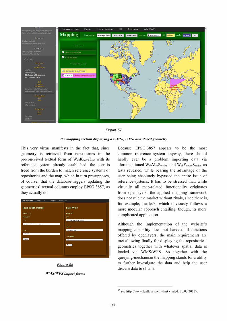
- 64 -
Figure 57
the mapping section displaying a WMS-, WFS- and stored geometry
This very virtue manifests in the fact that, sincegeometry is retrieved from repositories in thepreconceived textual form of WellKnownText with itsreference system already established, the user isfreed from the burden to match reference systems ofrepositories and the map, which in turn presupposes,of course, that the database-triggers updating thegeometries’ textual columns employ EPSG:3857, asthey actually do.
Figure 58
WMS/WFS import-forms
Because EPSG:3857 appears to be the mostcommon reference system anyway, there shouldhardly ever be a problem importing data viaaforementioned WebMapService- and WebFeatureService, astests revealed, while bearing the advantage of theuser being absolutely bypassed the entire issue ofreference-systems. It has to be stressed that, whilevirtually all map-related functionality originatesfrom openlayers, the applied mapping-frameworkdoes not rule the market without rivals, since there is,for example, leaflet93, which obviously follows amore modular approach entailing, though, its morecomplicated application.
Although the implementation of the website’smapping-capability does not harvest all functionsoffered by openlayers, the main requirements aremet allowing finally for displaying the repositories’geometries together with whatever spatial data isloaded via WMS/WFS. So together with thequerying-mechanism the mapping stands for a utilityto further investigate the data and help the userdiscern data to obtain.
93 see http://www.leafletjs.com <last visited: 20.03.2017>.
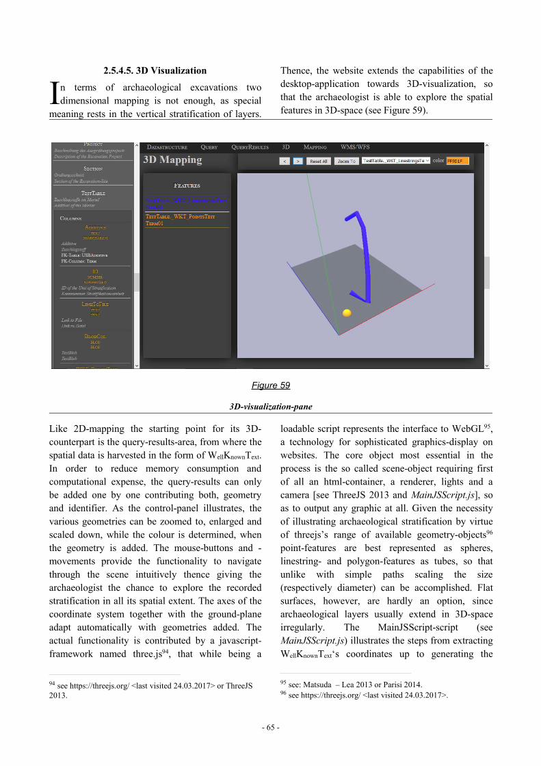
- 65 -
2.5.4.5. 3D Visualization
n terms of archaeological excavations twodimensional mapping is not enough, as special
meaning rests in the vertical stratification of layers.
Thence, the website extends the capabilities of thedesktop-application towards 3D-visualization, sothat the archaeologist is able to explore the spatialfeatures in 3D-space (see Figure 59).
Figure 59
3D-visualization-pane
Like 2D-mapping the starting point for its 3D-counterpart is the query-results-area, from where thespatial data is harvested in the form of WellKnownText.In order to reduce memory consumption andcomputational expense, the query-results can onlybe added one by one contributing both, geometryand identifier. As the control-panel illustrates, thevarious geometries can be zoomed to, enlarged andscaled down, while the colour is determined, whenthe geometry is added. The mouse-buttons and -movements provide the functionality to navigatethrough the scene intuitively thence giving thearchaeologist the chance to explore the recordedstratification in all its spatial extent. The axes of thecoordinate system together with the ground-planeadapt automatically with geometries added. Theactual functionality is contributed by a javascript-framework named three.js94, that while being a
94 see https://threejs.org/ <last visited 24.03.2017> or ThreeJS2013.
loadable script represents the interface to WebGL95,a technology for sophisticated graphics-display onwebsites. The core object most essential in theprocess is the so called scene-object requiring firstof all an html-container, a renderer, lights and acamera [see ThreeJS 2013 and MainJSScript.js], soas to output any graphic at all. Given the necessityof illustrating archaeological stratification by virtueof threejs’s range of available geometry-objects96point-features are best represented as spheres,linestring- and polygon-features as tubes, so thatunlike with simple paths scaling the size(respectively diameter) can be accomplished. Flatsurfaces, however, are hardly an option, sincearchaeological layers usually extend in 3D-spaceirregularly. The MainJSScript-script (seeMainJSScript.js) illustrates the steps from extractingWellKnownText‘s coordinates up to generating the
95 see: Matsuda – Lea 2013 or Parisi 2014.96 see https://threejs.org/ <last visited 24.03.2017>.
I
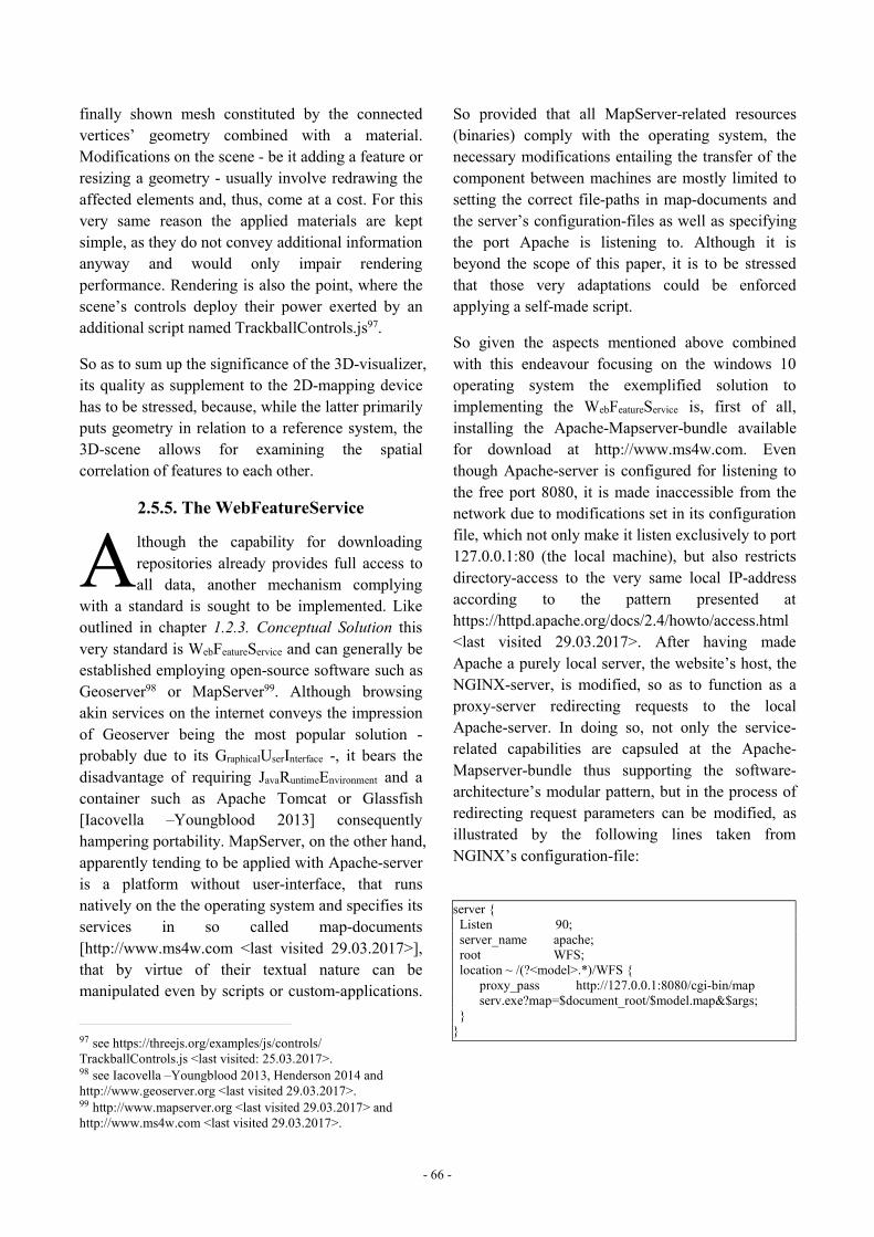
- 66 -
finally shown mesh constituted by the connectedvertices’ geometry combined with a material.Modifications on the scene - be it adding a feature orresizing a geometry - usually involve redrawing theaffected elements and, thus, come at a cost. For thisvery same reason the applied materials are keptsimple, as they do not convey additional informationanyway and would only impair renderingperformance. Rendering is also the point, where thescene’s controls deploy their power exerted by anadditional script named TrackballControls.js97.
So as to sum up the significance of the 3D-visualizer,its quality as supplement to the 2D-mapping devicehas to be stressed, because, while the latter primarilyputs geometry in relation to a reference system, the3D-scene allows for examining the spatialcorrelation of features to each other.
2.5.5. The WebFeatureService
lthough the capability for downloadingrepositories already provides full access toall data, another mechanism complying
with a standard is sought to be implemented. Likeoutlined in chapter 1.2.3. Conceptual Solution thisvery standard is WebFeatureService and can generally beestablished employing open-source software such asGeoserver98 or MapServer99. Although browsingakin services on the internet conveys the impressionof Geoserver being the most popular solution -probably due to its GraphicalUserInterface -, it bears thedisadvantage of requiring JavaRuntimeEnvironment and acontainer such as Apache Tomcat or Glassfish[Iacovella –Youngblood 2013] consequentlyhampering portability. MapServer, on the other hand,apparently tending to be applied with Apache-serveris a platform without user-interface, that runsnatively on the the operating system and specifies itsservices in so called map-documents[http://www.ms4w.com <last visited 29.03.2017>],that by virtue of their textual nature can bemanipulated even by scripts or custom-applications.
97 see https://threejs.org/examples/js/controls/TrackballControls.js <last visited: 25.03.2017>.98 see Iacovella –Youngblood 2013, Henderson 2014 andhttp://www.geoserver.org <last visited 29.03.2017>.99 http://www.mapserver.org <last visited 29.03.2017> andhttp://www.ms4w.com <last visited 29.03.2017>.
So provided that all MapServer-related resources(binaries) comply with the operating system, thenecessary modifications entailing the transfer of thecomponent between machines are mostly limited tosetting the correct file-paths in map-documents andthe server’s configuration-files as well as specifyingthe port Apache is listening to. Although it isbeyond the scope of this paper, it is to be stressedthat those very adaptations could be enforcedapplying a self-made script.
So given the aspects mentioned above combinedwith this endeavour focusing on the windows 10operating system the exemplified solution toimplementing the WebFeatureService is, first of all,installing the Apache-Mapserver-bundle availablefor download at http://www.ms4w.com. Eventhough Apache-server is configured for listening tothe free port 8080, it is made inaccessible from thenetwork due to modifications set in its configurationfile, which not only make it listen exclusively to port127.0.0.1:80 (the local machine), but also restrictsdirectory-access to the very same local IP-addressaccording to the pattern presented athttps://httpd.apache.org/docs/2.4/howto/access.html<last visited 29.03.2017>. After having madeApache a purely local server, the website’s host, theNGINX-server, is modified, so as to function as aproxy-server redirecting requests to the localApache-server. In doing so, not only the service-related capabilities are capsuled at the Apache-Mapserver-bundle thus supporting the software-architecture’s modular pattern, but in the process ofredirecting request parameters can be modified, asillustrated by the following lines taken fromNGINX’s configuration-file:
server {Listen 90;server_name apache;root WFS;location ~ /(?<model>.*)/WFS {
proxy_pass http://127.0.0.1:8080/cgi-bin/mapserv.exe?map=$document_root/$model.map&$args;
}}
A
- 67 -
Those lines100 define, first of all, that only requestsfrom port 90 are redirected and that the root-directory for referenced files is WFS, a subdirectoryin the NGINX folder. The WFS-directory is theplace, where aforementioned map-documentsdescribing the service reside. Since it is defined asroot and settled relative to the primary-server’sdirectory, it can be referenced via the variable$document_root. The phrase following ‘location’represents the filter for the parts of the URI tailingthe server- and port-specification, so that onlyrequests in the form of‘http://ipAddress:port/datamodel/wfs’ are handled.The data-model’s name is stored in a variable, inorder to be used in the query-string sent to theApache-server. The query-string of the originalrequest is appended to the modified URI via thevariable &args, as visible in the section starting with‘proxy_pass’ representing the proxy-target. Asillustrated by the proxy_pass-directive, MapServerrequires not only navigating to the mapserv.exe-file,but also a parameter hinting the input-map-file.Hence, the proxy-mechanism hides the MapServer-specific input and leaves only the WebFeatrueService-related parameters for the user to set.
Like already implied by the foregoing paragraphseach data-model possesses its own WebFeatureServicespecified in a separate map-document stored in theNGINX-server’s subdirectory named WFS.
The following lines exemplify a basic example ofsuch map-document101 representing aWebFeatureService-implementation, that correspondswith the data-model outlined above (see 2.2. Data-Model) and simulates the existence of a repositorynamed Repository01:
MAPNAME "WFS_server"STATUS ON
100 for information in how to configure NGINX, see forexample: http://nginx.org/en/docs/beginners_guide.html <lastvisited: 29.03.2017>.101 for information on how to structure map-documents see:http://www.mapserver.org/ogc/wfs_server.html <last visited:29.03.2017> andhttp://www.mapserver.org/input/vector/sqlite.html <last visited:29.03.2017>.On all the available parameters see:http://www.mapserver.org/documentation.html <last visited:31.03.2017>.
WEBMETADATA"wfs_title" "ArchaeologicalDatabase""wfs_onlineresource" "http://localhost:90/
WFSTestModel/WFS""wfs_srs" "EPSG:3857""wfs_abstract" "Database for arch. Data.""wfs_enable_request" "*""ows_keywordlist" """ows_fees" """ows_accessconstraints" """ows_contactorganization" """ows_contactperson" """ows_service_onlineresource" """ows_contactposition" """ows_contactvoicetelephone" """ows_contactfacsimiletelephone" """ows_address" """ows_city" """ows_stateorprovince" """ows_postcode" """ows_country" """ows_contactelectronicmailaddress" """ows_hoursofservice" """ows_contactinstructions" """ows_role" ""ENDEND
LAYERNAME Repostory01_Find_LocationTYPE POINTCONNECTIONTYPE OGRCONNECTION "path/to/Repository01.sqlite"DATA "Select ID, Transform(Location,3857) from
Find"EXTENT -20026376.39 -20048966 20026376.39
20048966PROJECTION
"init=epsg:3857"ENDSTATUS ONMETADATA
wfs_title "Location of Find"wfs_featureid "ID"gml_include_items "all"
ENDEND
LAYERNAME Repostory01_Section_LocationTYPE POLYGONCONNECTIONTYPE OGRCONNECTION "path/to/Repository01.sqlite"DATA "Select SectionID, Transform(Location,
3857) from Section"EXTENT -20026376.39 -20048966 20026376.39
20048966PROJECTION
"init=epsg:3857"ENDSTATUS ONMETADATA
wfs_title "Location of Section"wfs_featureid "SectionID"
- 68 -
gml_include_items "all"ENDEND
LAYERNAME Repostory01_Profile_LocationTYPE LINECONNECTIONTYPE OGRCONNECTION "path/to/Repository01.sqlite"DATA "Select ProfileID || “_” || SectionID AS
ID,Transform(Location, 3857) from Profile"EXTENT -20026376.39 -20048966 20026376.39
20048966PROJECTION
"init=epsg:3857"ENDSTATUS ONMETADATA
wfs_title "Location of Profile"wfs_featureid "ID"gml_include_items "all"
ENDEND
LAYERNAME Repostory01_Site_LocationTYPE POLYGONCONNECTIONTYPE OGRCONNECTION "path/to/Repository01.sqlite"DATA "Select SiteID, Transform(Location,
3857) from Site"EXTENT -20026376.39 -20048966 20026376.39
20048966PROJECTION
"init=epsg:3857"ENDSTATUS ONMETADATA
wfs_title "Location of Site"wfs_featureid "SiteID"gml_include_items "all"
ENDEND
LAYERNAME Repostory01_Building_LocationTYPE POLYGONCONNECTIONTYPE OGRCONNECTION "path/to/Repository01.sqlite"DATA "Select USNr, Transform(Location, 3857)
from USBuilding"EXTENT -20026376.39 -20048966 20026376.39
20048966PROJECTION
"init=epsg:3857"ENDSTATUS ONMETADATA
wfs_title "Location of Building"wfs_featureid "USNr"gml_include_items "all"
ENDEND
LAYERNAME Repostory01_Building_TopSurfaceTYPE POINT
CONNECTIONTYPE OGRCONNECTION "path/to/Repository01.sqlite"DATA "Select USNr, Transform(UpSurface, 3857)
from USBuilding"EXTENT -20026376.39 -20048966 20026376.39
20048966PROJECTION
"init=epsg:3857"ENDSTATUS ONMETADATA
wfs_title "Top-Surface of Building"wfs_featureid "USNr"gml_include_items "all"
ENDEND
LAYERNAME Repostory01_Building_BottomSurfaceTYPE POINTCONNECTIONTYPE OGRCONNECTION "path/to/Repository01.sqlite"DATA "Select USNr, Transform(DownSurface, 3857)
from USBuilding"EXTENT -20026376.39 -20048966 20026376.39
20048966PROJECTION
"init=epsg:3857"ENDSTATUS ONMETADATA
wfs_title "Bottom-Surface of Building"wfs_featureid "USNr"gml_include_items "all"
ENDEND
LAYERNAME Repostory01_HumanRemains_LocationTYPE POLYGONCONNECTIONTYPE OGRCONNECTION "path/to/Repository01.sqlite"DATA "Select Individual, Transform(Location,
3857) from USHumanRemains"EXTENT -20026376.39 -20048966 20026376.39
20048966PROJECTION
"init=epsg:3857"ENDSTATUS ONMETADATA
wfs_title "Location of HumanRemains"wfs_featureid "Individual"gml_include_items "all"
ENDEND
LAYERNAME Repostory01_Interface_LocationTYPE POLYGONCONNECTIONTYPE OGRCONNECTION "path/to/Repository01.sqlite"DATA "Select USNr, Transform(Location,
3857) from USInterface"EXTENT -20026376.39 -20048966 20026376.39
20048966PROJECTION
- 69 -
"init=epsg:3857"ENDSTATUS ONMETADATA
wfs_title "Location of Interface"wfs_featureid "USNr"gml_include_items "all"
ENDEND
LAYERNAME Repostory01_Interface_SurfaceTYPE POINTCONNECTIONTYPE OGRCONNECTION "path/to/Repository01.sqlite"DATA "Select USNr, Transform(Surface,3857)
from USInterface"EXTENT -20026376.39 -20048966 20026376.39
20048966PROJECTION
"init=epsg:3857"ENDSTATUS ONMETADATA
wfs_title "Surface of Interface"wfs_featureid "USNr"gml_include_items "all"
ENDEND
LAYERNAME Repostory01_Sediment_LocationTYPE POLYGONCONNECTIONTYPE OGRCONNECTION "path/to/Repository01.sqlite"DATA "Select USNr, Transform(Location, 3857)
from USSediment"EXTENT -20026376.39 -20048966 20026376.39
20048966PROJECTION
"init=epsg:3857"ENDSTATUS ONMETADATA
wfs_title "Location of Sediment"wfs_featureid "USNr"gml_include_items "all"
ENDEND
LAYERNAME Repostory01_Sediment_TopSurfaceTYPE POINTCONNECTIONTYPE OGRCONNECTION "path/to/Repository01.sqlite"DATA "Select USNr, Transform(UpSurface, 3857)
from USSediment"EXTENT -20026376.39 -20048966 20026376.39
20048966PROJECTION
"init=epsg:3857"ENDSTATUS ONMETADATA
wfs_title "Top-Surface of Sediment"wfs_featureid "USNr"gml_include_items "all"
ENDEND
LAYERNAME Repostory01_Sediment_BottomSurfaceTYPE POINTCONNECTIONTYPE OGRCONNECTION "path/to/Repository01.sqlite"DATA "Select USNr, Transform(DownSurface,3857)
from USSediment"EXTENT -20026376.39 -20048966 20026376.39
20048966PROJECTION
"init=epsg:3857"ENDSTATUS ONMETADATA
wfs_title "Bottom-Surface of Sediment"wfs_featureid "USNr"gml_include_items "all"
ENDEND
LAYERNAME Repostory01_Wood_LocationTYPE POLYGONCONNECTIONTYPE OGRCONNECTION "path/to/Repository01.sqlite"DATA "Select USNr, Transform(Location, 3857)
from USWood"EXTENT -20026376.39 -20048966 20026376.39
20048966PROJECTION
"init=epsg:3857"ENDSTATUS ONMETADATA
wfs_title "Location of Wood"wfs_featureid "USNr"gml_include_items "all"
ENDEND
LAYERNAME Repostory01_Wood_TopSurfaceTYPE POINTCONNECTIONTYPE OGRCONNECTION "path/to/Repository01.sqlite"DATA "Select USNr, Transform(UpSurface, 3857)
from USWood"EXTENT -20026376.39 -20048966 20026376.39
20048966PROJECTION
"init=epsg:3857"ENDSTATUS ONMETADATA
wfs_title "Top-Surface of Wood"wfs_featureid "USNr"gml_include_items "all"
ENDEND
LAYERNAME Repostory01_Wood_BottomSurfaceTYPE POINTCONNECTIONTYPE OGR
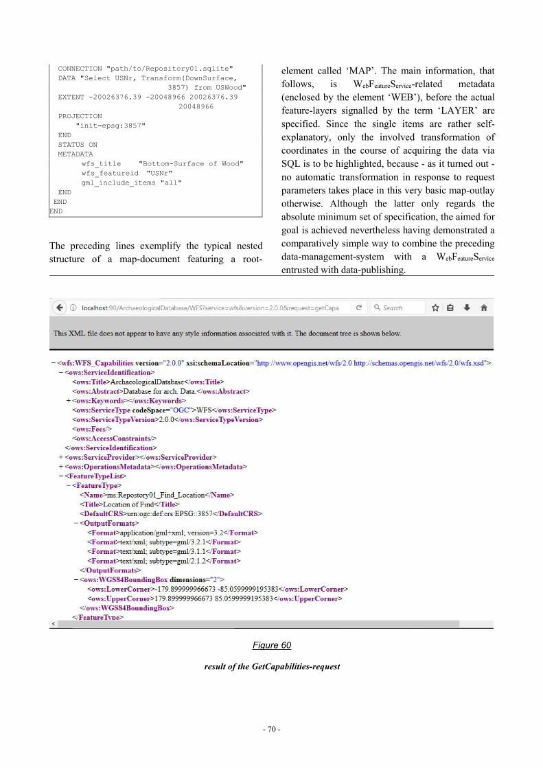
- 70 -
CONNECTION "path/to/Repository01.sqlite"DATA "Select USNr, Transform(DownSurface,
3857) from USWood"EXTENT -20026376.39 -20048966 20026376.39
20048966PROJECTION
"init=epsg:3857"ENDSTATUS ONMETADATA
wfs_title "Bottom-Surface of Wood"wfs_featureid "USNr"gml_include_items "all"
ENDENDEND
The preceding lines exemplify the typical nestedstructure of a map-document featuring a root-
element called ‘MAP’. The main information, thatfollows, is WebFeatureService-related metadata(enclosed by the element ‘WEB’), before the actualfeature-layers signalled by the term ‘LAYER’ arespecified. Since the single items are rather self-explanatory, only the involved transformation ofcoordinates in the course of acquiring the data viaSQL is to be highlighted, because - as it turned out -no automatic transformation in response to requestparameters takes place in this very basic map-outlayotherwise. Although the latter only regards theabsolute minimum set of specification, the aimed forgoal is achieved nevertheless having demonstrated acomparatively simple way to combine the precedingdata-management-system with a WebFeatureServiceentrusted with data-publishing.
Figure 60
result of the GetCapabilities-request
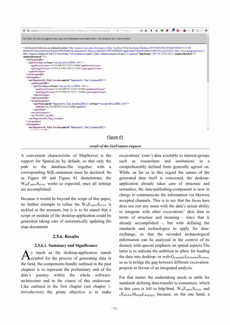
- 71 -
Figure 61
result of the GetFeature-request
A convenient characteristic of MapServer is thesupport for SpatiaLite by default, so that only thepath to the database-file together with acorresponding SQL-statement must be declared. Soas Figure 60 and Figure 61 demonstrate, theWebFeatureService works as expected, once all settingsare accomplished.
Because it would be beyond the scope of this paper,no further attempts to refine the WebFeatureService istackled at the moment, but it is to be stated that ascript or module of the desktop-application could begenerated taking care of automatically updating themap-documents
2.5.6. Results
2.5.6.1. Summary and Significance
s much as the desktop-application standssymbol for the process of generating data in
the field, the components-bundle outlined in the pastchapters is to represent the preliminary end of thedata’s journey within the whole software-architecture and in the course of this endeavour.Like outlined in the first chapter (see chapter 1.Introduction) the prime objective is to make
excavations’ (raw-) data available to interest-groupssuch as researchers and institutions in acomprehensibly defined form generally agreed on.While, as far as in this regard the nature of thegenerated data itself is concerned, the desktop-application already takes care of structure andsemantics, the data-publishing-component is now incharge to communicate the information via likewiseaccepted channels. This is to say that the focus heredoes not rest any more with the data’s actual abilityto integrate with other excavations’ akin data interms of structure and meaning - since that isalready accomplished -, but with defining thestandards and technologies to apply for data-exchange, so that the recorded archaeologicalinformation can be analysed in the context of itsdomain with special emphasis on spatial aspects.Thelatter is to indicate the ambition to allow for loadingthe data into desktop- or web-GeographicInformationSystems,so as to bridge the gap between different excavation-projects in favour of an integrated analysis.
For that matter the undertaking needs to settle forstandards defining data-transfer to consumers, whichin this case is left to http/html, WebFeatureService andeXtensibleMarkupLanguage, because, on the one hand, a
A
- 72 -
website can be viewed on any device featuring abrowser, while, on the other hand, WebFeatureService(using eXtensibleMarkupLanguage) basically representsstructured text-documents accessible by virtually allcomputers and processible by commonGeographicInformationSystems.
In order to fulfill those standards and protocols onthe way to aforementioned overall objective, thisendeavour is explicitly meant to derive advantagefrom already existing and approved technologies,that are in fact hardly subject to debate in the case ofthe website (utilizing html, javascript and cascadingstyle sheets), but are chosen by fitness for server-side tasks employing an NGINX-server and PHP.By connecting the server with the open-sourceMapServer-software-bundle facilitatingWebFeatureService all measures are finally assembled, inorder to support a full work-flow for archaeologicalraw-data.
From the remote user’s view this very work-flowstarts with calling the website, that, first of all,intends to allow for browsing the differentcategories of information in an appearance suitingthe data’s character,102 so that consequently the usergets an impression of the data he/she might want toobtain. Another important function of the websiteare its download-capabilities, that on the one handequip the visitor with all the information necessaryfor setting up the exact same data-model togetherwith the corresponding glossaries, but on the otherhand offer the database-files themselves fordownload. Since the latter may be regarded a veryopen concept supposed to represent a paradigm offreely available archaeological data and, thus, afeature rather suitable for project internal datatransfer, the access to certain downloads couldeasily be controlled by restricting the service to IP-addresses of local networks or by introducing asystem of user-accounts.
Having gained an impression of the data-storethrough the website the user then can request andobtain the data via WebFeatureService.
102 This simply means, that - in contrast to alphanumeric data -spatial data is displayed in maps and graphics, while the data-model is illustrated as a graph.
2.5.6.2. Conclusion
rrespective of demonstrating a way of assemblinga software-construct working as outlined in
chapter 1.2.3. Conceptual Solution this case-studyadduced several findings, the most essential ofwhich centers upon the database-system. Since forthe data-store’s backbone the file-based database-system SQLite is chosen over a database-server-application like PostgreSQL/PostGIS, variousparticularities must be considered: As the constructis not client to a database-server, but ratherestablishes database-connections itself by virtue ofincluded libraries, it has to coordinate all database-related access-(rights-)management, which, however,regarding remote access is not much of a concern,because remote read-connections do not interfereharmfully with the single desktop-application’sreading and writing. Through the chosen database-system, though, the engineered software-bundle isnot only better capsuled and portable, but alsobypasses a possible performance-bottleneck causedby an intermediary database-server. As a result, notonly can database-files be made available fordownload, but the general pattern of excavation-databeing usually organised in campaign-orientedgroups is resembled by the structure of theapplications. As a consequence, data is to be queried(on the website) and requested (via WebFeatureService)separately for each repository, which would beconsidered a downside, if this endeavour wasexpected to end in an extensive institution-level-datastore, while in fact it is only to be deployed atproject scale.
As a means to promote a modular design andexchangeability of the major components, the onlysuitable touch points of desktop-application andserver-related functionality are the resource-files,which means that the desktop-application does notintend to control the server, whereas the latter doesits tasks using the resources it finds. The choice ofthe main server was geared by the simplicity - and,thus, portability - of NGINX, so that the server-component can be set up on any system simply byplacing the server’s files to the correct place of thesoftware-architecture’s directories-tree. As asupporting measure the server-side scripts are
I
- 73 -
constructed to look up dependencies relative to theirown position rather than resorting to absolute paths.
In contrast to the server-side tasks having turned outpretty straightforward to implement a sophisticatedclient-side functionality required the most effort, soas to guarantee a satisfactory browsing experience.Like foreseen in the planning phase the challenge inimplementing the website’s capabilities is not somuch rooted in developing all functions fromscratch, but integrating existing JavaScript-frameworks, in order to exploit their functionality.In this process, however, an upload-mechanism isomitted, for it is not really required, whereby itsabsence eliminates some security-considerationscompletely. The ability to download referencedbinary-files from the website, on the other hand, - asstraightforward to implement as it is (seeGetFile.php) - fulfills another essential task giventhe fact that archaeological records tend to beaccompanied by photos and akin data. Since thosebinary files are stored outside the databases, file-sizeand database-connections are of no concern, so as toease downloading.
Regarding the WebFeatureService the available solutionsturned out to provide functionality far beyond therequirements of this project, but nevertheless servethe purpose of having the WebFeatureService installed ascompletely replaceable component. Employing aproxy mechanism redirecting requests to a localserver hosting all WebFeatureService related functions -as outlined in chapter 2.5.5. The WFS - not onlyencapsulation is enforced, but the user requests canbe furnished with additional parameters. Becauseacquiring the data can be achieved via SQL-statements, all sorts of table-joins can be madeopening up the possibility to combine virtually allstored (or processed) data as attributes to geometriesin stock or calculated. Due to Mapserver’s paradigmof map-documents specifying the services, it allowsfor future automation. As a consequence theWebFeatureService with its standardized capabilities isan ideal interface to spatial data - such asarchaeological records - and may additionally servewell as source for Research Infrastructures, sincethe data-model available for download containingmappings to an ontology lets an infrastructureunderstand structure and meaning of the data-store.
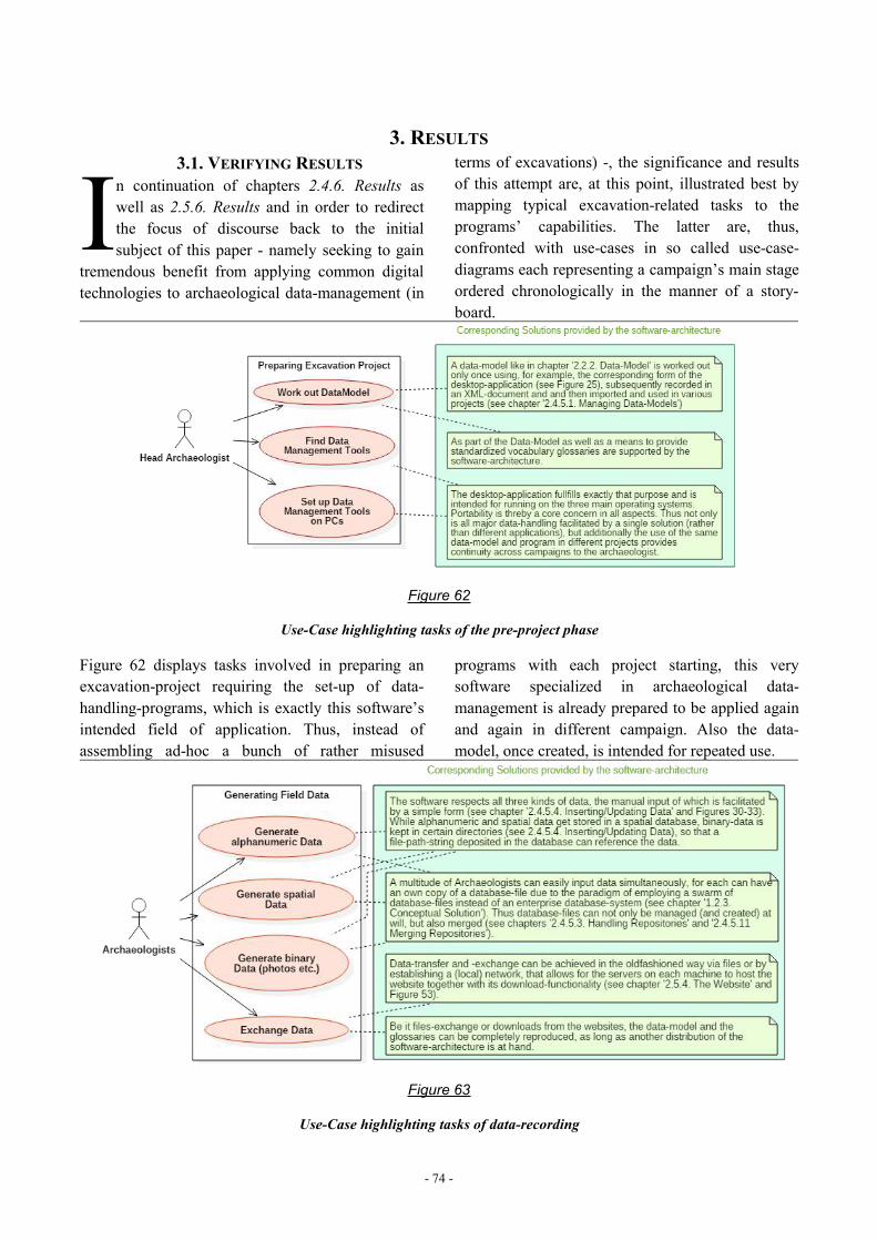
- 74 -
3. RESULTS3.1. VERIFYING RESULTS
n continuation of chapters 2.4.6. Results aswell as 2.5.6. Results and in order to redirectthe focus of discourse back to the initialsubject of this paper - namely seeking to gain
tremendous benefit from applying common digitaltechnologies to archaeological data-management (in
terms of excavations) -, the significance and resultsof this attempt are, at this point, illustrated best bymapping typical excavation-related tasks to theprograms’ capabilities. The latter are, thus,confronted with use-cases in so called use-case-diagrams each representing a campaign’s main stageordered chronologically in the manner of a story-board.
Figure 62
Use-Case highlighting tasks of the pre-project phase
Figure 62 displays tasks involved in preparing anexcavation-project requiring the set-up of data-handling-programs, which is exactly this software’sintended field of application. Thus, instead ofassembling ad-hoc a bunch of rather misused
programs with each project starting, this verysoftware specialized in archaeological data-management is already prepared to be applied againand again in different campaign. Also the data-model, once created, is intended for repeated use.
Figure 63
Use-Case highlighting tasks of data-recording
I
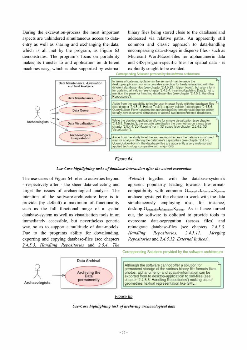
- 75 -
During the excavation-process the most importantaspects are unhindered simultaneous access to data-entry as well as sharing and exchanging the data,which is all met by the program, as Figure 63demonstrates. The program’s focus on portabilitymakes its transfer to and application on differentmachines easy, which is also supported by external
binary files being stored close to the databases andaddressed via relative paths. An apparently stillcommon and classic approach to data-handlingencompassing data-storage in disperse files - such asMicrosoft Word/Excel-files for alphanumeric dataand GIS-program-specific files for spatial data - isexplicitly sought to be avoided.
Figure 64
Use-Case highlighting tasks of database-interaction after the actual excavation
The use-cases of Figure 64 refer to activities beyond- respectively after - the sheer data-collecting andtarget the issues of archaeological analysis. Theintention of the software-architecture here is toprovide (by default) a maximum of functionalitysuch as the full functional range of a spatialdatabase-system as well as visualisation tools in animmediately accessible, but nevertheless genericway, so as to support a multitude of data-models.Due to the programs ability for downloading,exporting and copying database-files (see chapters2.4.5.3. Handling Repositories and 2.5.4. The
Website) together with the database-system’sapparent popularity leading towards file-format-compatibility with common GeographicInformationSystemsarchaeologists get the chance to work with the datasimultaneously employing also, for instance,desktop-GeographicInformationSystems. As it hence turnedout, the software is obliqued to provide tools toovercome data-segregation (across files) andreintegrate database-files (see chapters 2.4.5.3.Handling Repositories, 2.4.5.11. MergingRepositories and 2.4.5.12. External Indices).
Figure 65
Use-Case highlighting task of archiving archaeological data
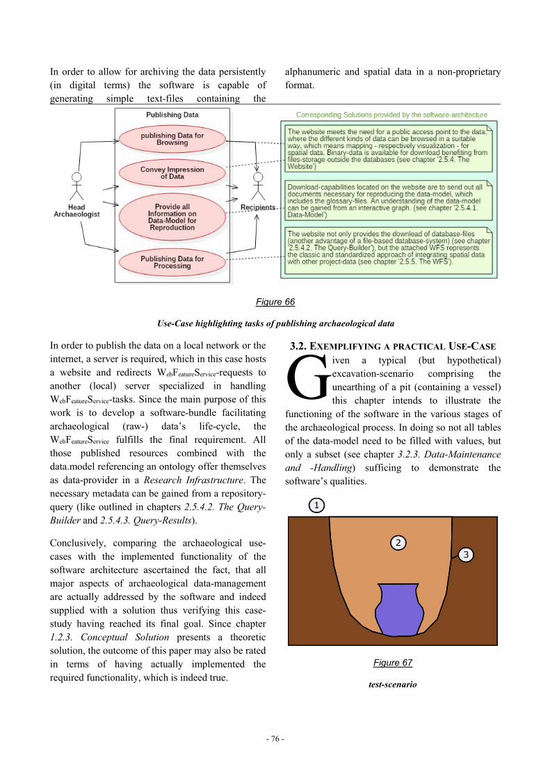
- 76 -
In order to allow for archiving the data persistently(in digital terms) the software is capable ofgenerating simple text-files containing the
alphanumeric and spatial data in a non-proprietaryformat.
Figure 66
Use-Case highlighting tasks of publishing archaeological data
In order to publish the data on a local network or theinternet, a server is required, which in this case hostsa website and redirects WebFeatureService-requests toanother (local) server specialized in handlingWebFeatureService-tasks. Since the main purpose of thiswork is to develop a software-bundle facilitatingarchaeological (raw-) data’s life-cycle, theWebFeatureService fulfills the final requirement. Allthose published resources combined with thedata.model referencing an ontology offer themselvesas data-provider in a Research Infrastructure. Thenecessary metadata can be gained from a repository-query (like outlined in chapters 2.5.4.2. The Query-Builder and 2.5.4.3. Query-Results).
Conclusively, comparing the archaeological use-cases with the implemented functionality of thesoftware architecture ascertained the fact, that allmajor aspects of archaeological data-managementare actually addressed by the software and indeedsupplied with a solution thus verifying this case-study having reached its final goal. Since chapter1.2.3. Conceptual Solution presents a theoreticsolution, the outcome of this paper may also be ratedin terms of having actually implemented therequired functionality, which is indeed true.
3.2. EXEMPLIFYING A PRACTICAL USE-CASEiven a typical (but hypothetical)excavation-scenario comprising theunearthing of a pit (containing a vessel)this chapter intends to illustrate the
functioning of the software in the various stages ofthe archaeological process. In doing so not all tablesof the data-model need to be filled with values, butonly a subset (see chapter 3.2.3. Data-Maintenanceand -Handling) sufficing to demonstrate thesoftware’s qualities.
Figure 67
test-scenario
G
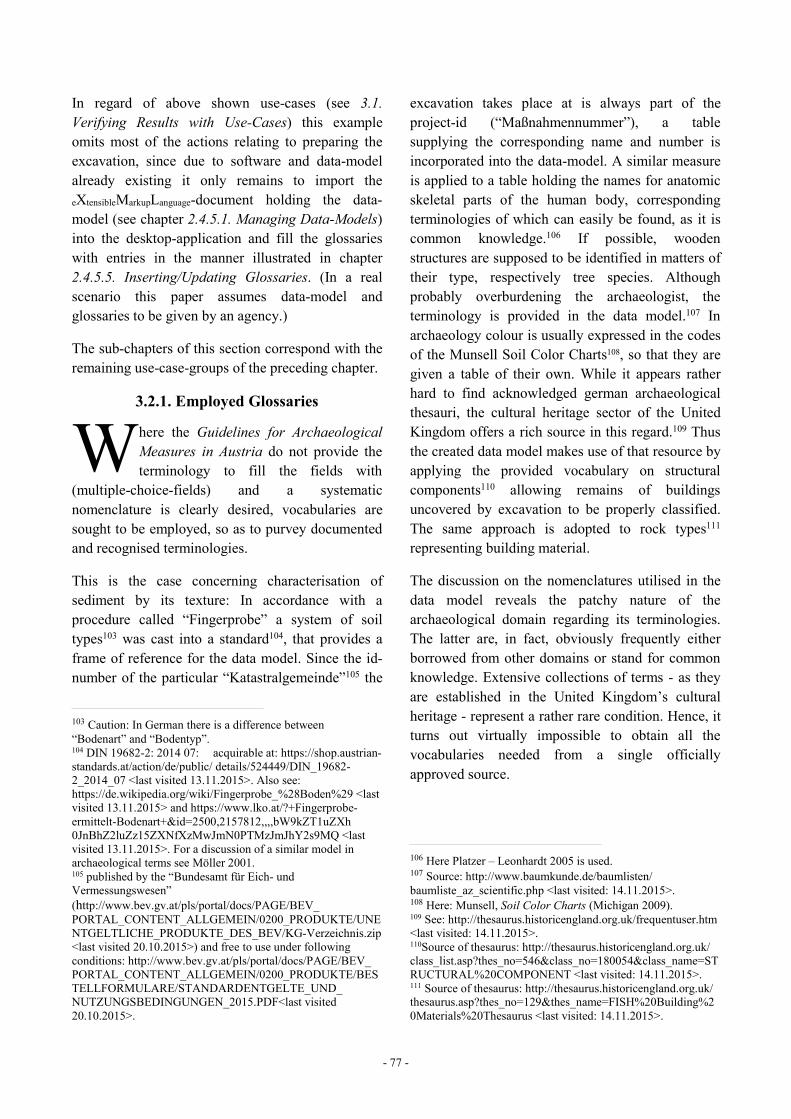
- 77 -
In regard of above shown use-cases (see 3.1.Verifying Results with Use-Cases) this exampleomits most of the actions relating to preparing theexcavation, since due to software and data-modelalready existing it only remains to import theeXtensibleMarkupLanguage-document holding the data-model (see chapter 2.4.5.1. Managing Data-Models)into the desktop-application and fill the glossarieswith entries in the manner illustrated in chapter2.4.5.5. Inserting/Updating Glossaries. (In a realscenario this paper assumes data-model andglossaries to be given by an agency.)
The sub-chapters of this section correspond with theremaining use-case-groups of the preceding chapter.
3.2.1. Employed Glossaries
here the Guidelines for ArchaeologicalMeasures in Austria do not provide theterminology to fill the fields with
(multiple-choice-fields) and a systematicnomenclature is clearly desired, vocabularies aresought to be employed, so as to purvey documentedand recognised terminologies.
This is the case concerning characterisation ofsediment by its texture: In accordance with aprocedure called “Fingerprobe” a system of soiltypes103 was cast into a standard104, that provides aframe of reference for the data model. Since the id-number of the particular “Katastralgemeinde”105 the
103 Caution: In German there is a difference between“Bodenart” and “Bodentyp”.104 DIN 19682-2: 2014 07: acquirable at: https://shop.austrian-standards.at/action/de/public/ details/524449/DIN_19682-2_2014_07 <last visited 13.11.2015>. Also see:https://de.wikipedia.org/wiki/Fingerprobe_%28Boden%29 <lastvisited 13.11.2015> and https://www.lko.at/?+Fingerprobe-ermittelt-Bodenart+&id=2500,2157812,,,,bW9kZT1uZXh0JnBhZ2luZz15ZXNfXzMwJmN0PTMzJmJhY2s9MQ <lastvisited 13.11.2015>. For a discussion of a similar model inarchaeological terms see Möller 2001.105 published by the “Bundesamt für Eich- undVermessungswesen”(http://www.bev.gv.at/pls/portal/docs/PAGE/BEV_PORTAL_CONTENT_ALLGEMEIN/0200_PRODUKTE/UNENTGELTLICHE_PRODUKTE_DES_BEV/KG-Verzeichnis.zip<last visited 20.10.2015>) and free to use under followingconditions: http://www.bev.gv.at/pls/portal/docs/PAGE/BEV_PORTAL_CONTENT_ALLGEMEIN/0200_PRODUKTE/BESTELLFORMULARE/STANDARDENTGELTE_UND_NUTZUNGSBEDINGUNGEN_2015.PDF<last visited20.10.2015>.
excavation takes place at is always part of theproject-id (“Maßnahmennummer”), a tablesupplying the corresponding name and number isincorporated into the data-model. A similar measureis applied to a table holding the names for anatomicskeletal parts of the human body, correspondingterminologies of which can easily be found, as it iscommon knowledge.106 If possible, woodenstructures are supposed to be identified in matters oftheir type, respectively tree species. Althoughprobably overburdening the archaeologist, theterminology is provided in the data model.107 Inarchaeology colour is usually expressed in the codesof the Munsell Soil Color Charts108, so that they aregiven a table of their own. While it appears ratherhard to find acknowledged german archaeologicalthesauri, the cultural heritage sector of the UnitedKingdom offers a rich source in this regard.109 Thusthe created data model makes use of that resource byapplying the provided vocabulary on structuralcomponents110 allowing remains of buildingsuncovered by excavation to be properly classified.The same approach is adopted to rock types111representing building material.
The discussion on the nomenclatures utilised in thedata model reveals the patchy nature of thearchaeological domain regarding its terminologies.The latter are, in fact, obviously frequently eitherborrowed from other domains or stand for commonknowledge. Extensive collections of terms - as theyare established in the United Kingdom’s culturalheritage - represent a rather rare condition. Hence, itturns out virtually impossible to obtain all thevocabularies needed from a single officiallyapproved source.
106 Here Platzer – Leonhardt 2005 is used.107 Source: http://www.baumkunde.de/baumlisten/baumliste_az_scientific.php <last visited: 14.11.2015>.108 Here: Munsell, Soil Color Charts (Michigan 2009).109 See: http://thesaurus.historicengland.org.uk/frequentuser.htm<last visited: 14.11.2015>.110Source of thesaurus: http://thesaurus.historicengland.org.uk/class_list.asp?thes_no=546&class_no=180054&class_name=STRUCTURAL%20COMPONENT <last visited: 14.11.2015>.111 Source of thesaurus: http://thesaurus.historicengland.org.uk/thesaurus.asp?thes_no=129&thes_name=FISH%20Building%20Materials%20Thesaurus <last visited: 14.11.2015>.
W
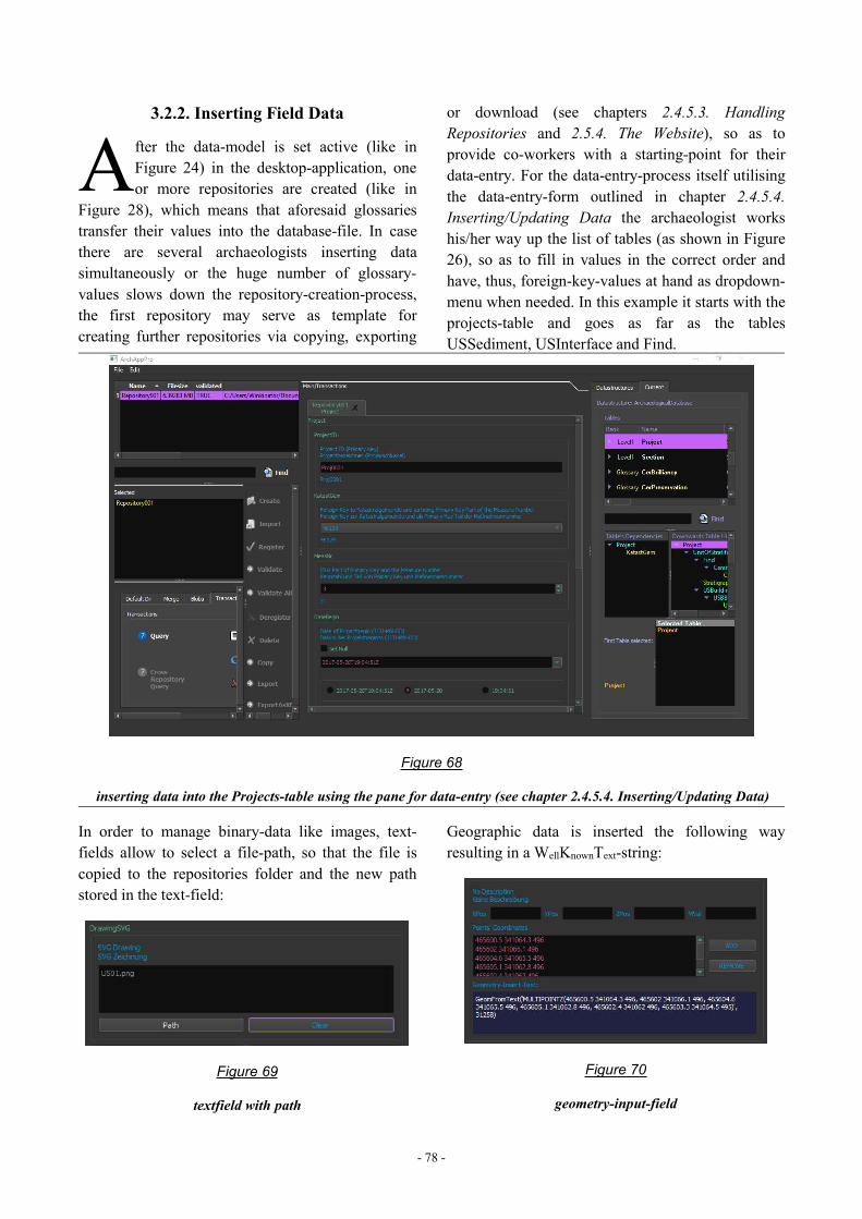
- 78 -
3.2.2. Inserting Field Data
fter the data-model is set active (like inFigure 24) in the desktop-application, oneor more repositories are created (like in
Figure 28), which means that aforesaid glossariestransfer their values into the database-file. In casethere are several archaeologists inserting datasimultaneously or the huge number of glossary-values slows down the repository-creation-process,the first repository may serve as template forcreating further repositories via copying, exporting
or download (see chapters 2.4.5.3. HandlingRepositories and 2.5.4. The Website), so as toprovide co-workers with a starting-point for theirdata-entry. For the data-entry-process itself utilisingthe data-entry-form outlined in chapter 2.4.5.4.Inserting/Updating Data the archaeologist workshis/her way up the list of tables (as shown in Figure26), so as to fill in values in the correct order andhave, thus, foreign-key-values at hand as dropdown-menu when needed. In this example it starts with theprojects-table and goes as far as the tablesUSSediment, USInterface and Find.
Figure 68
inserting data into the Projects-table using the pane for data-entry (see chapter 2.4.5.4. Inserting/Updating Data)
In order to manage binary-data like images, text-fields allow to select a file-path, so that the file iscopied to the repositories folder and the new pathstored in the text-field:
Figure 69
textfield with path
Geographic data is inserted the following wayresulting in a WellKnownText-string:
Figure 70
geometry-input-field
A
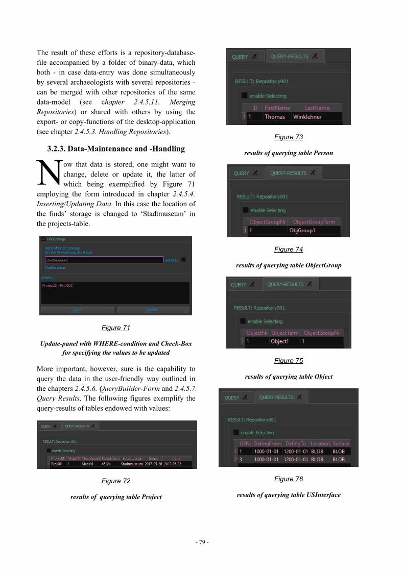
- 79 -
The result of these efforts is a repository-database-file accompanied by a folder of binary-data, whichboth - in case data-entry was done simultaneouslyby several archaeologists with several repositories -can be merged with other repositories of the samedata-model (see chapter 2.4.5.11. MergingRepositories) or shared with others by using theexport- or copy-functions of the desktop-application(see chapter 2.4.5.3. Handling Repositories).
3.2.3. Data-Maintenance and -Handling
ow that data is stored, one might want tochange, delete or update it, the latter ofwhich being exemplified by Figure 71
employing the form introduced in chapter 2.4.5.4.Inserting/Updating Data. In this case the location ofthe finds’ storage is changed to ‘Stadtmuseum’ inthe projects-table.
Figure 71
Update-panel with WHERE-condition and Check-Boxfor specifying the values to be updated
More important, however, sure is the capability toquery the data in the user-friendly way outlined inthe chapters 2.4.5.6. QueryBuilder-Form and 2.4.5.7.Query Results. The following figures exemplify thequery-results of tables endowed with values:
Figure 72
results of querying table Project
Figure 73
results of querying table Person
Figure 74
results of querying table ObjectGroup
Figure 75
results of querying table Object
Figure 76
results of querying table USInterface
N
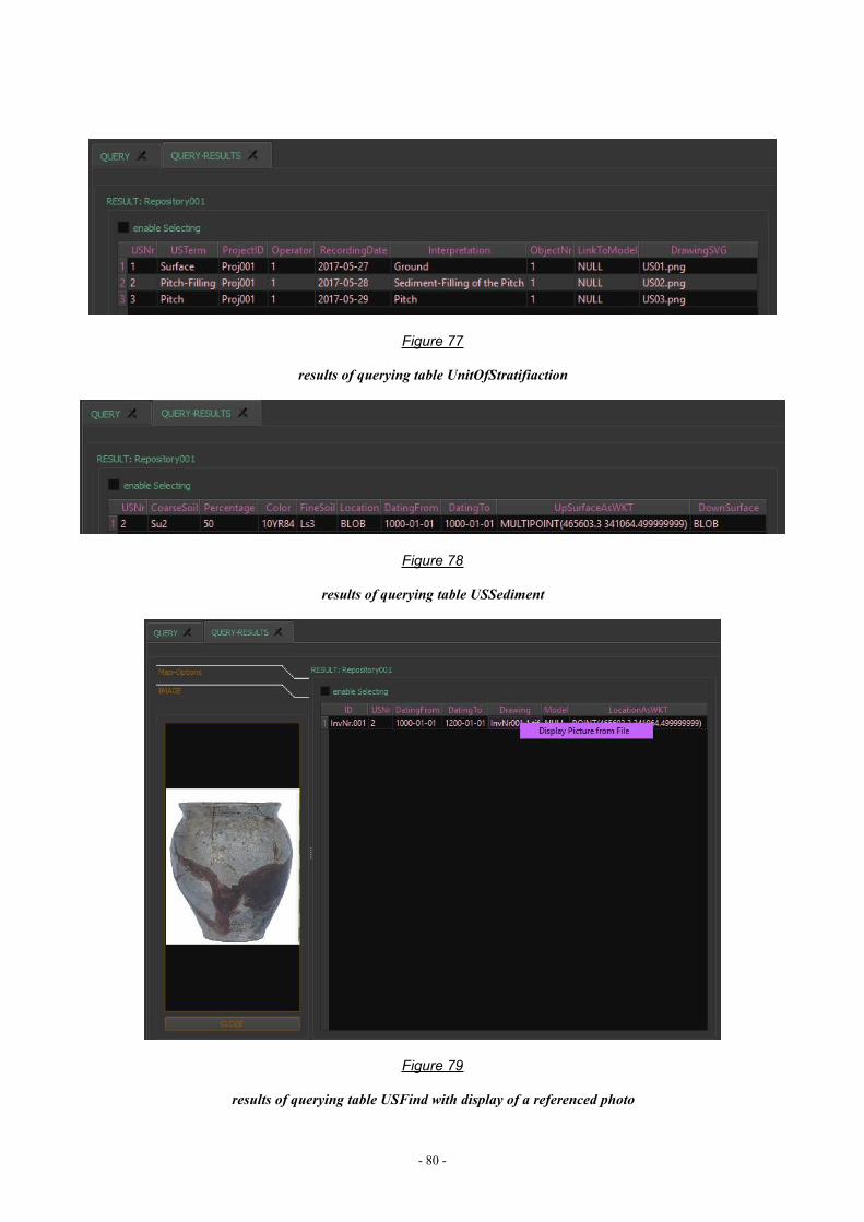
- 80 -
Figure 77
results of querying table UnitOfStratifiaction
Figure 78
results of querying table USSediment
Figure 79
results of querying table USFind with display of a referenced photo
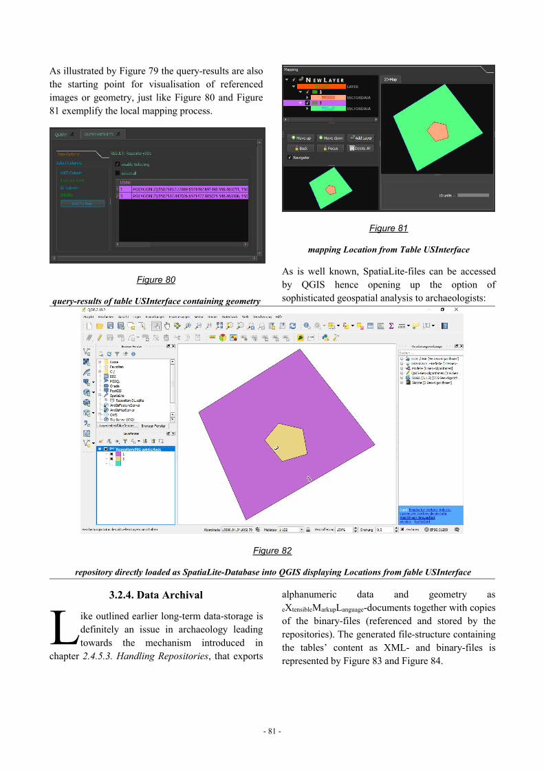
- 81 -
As illustrated by Figure 79 the query-results are alsothe starting point for visualisation of referencedimages or geometry, just like Figure 80 and Figure81 exemplify the local mapping process.
Figure 80
query-results of table USInterface containing geometry
Figure 81
mapping Location from Table USInterface
As is well known, SpatiaLite-files can be accessedby QGIS hence opening up the option ofsophisticated geospatial analysis to archaeologists:
Figure 82
repository directly loaded as SpatiaLite-Database into QGIS displaying Locations from fable USInterface
3.2.4. Data Archival
ike outlined earlier long-term data-storage isdefinitely an issue in archaeology leadingtowards the mechanism introduced in
chapter 2.4.5.3. Handling Repositories, that exports
alphanumeric data and geometry aseXtensibleMarkupLanguage-documents together with copiesof the binary-files (referenced and stored by therepositories). The generated file-structure containingthe tables’ content as XML- and binary-files isrepresented by Figure 83 and Figure 84.
L
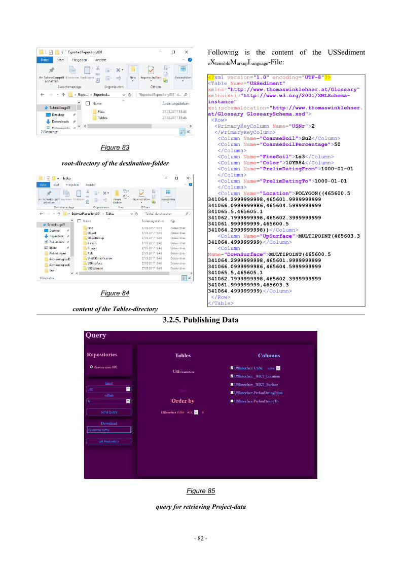
- 82 -
Figure 83
root-directory of the destination-folder
Figure 84
content of the Tables-directory
Following is the content of the USSedimenteXtensibleMarkupLanguage-File:
<?xml version="1.0" encoding="UTF-8"?><Table Name="USSediment"xmlns="http://www.thomaswinklehner.at/Glossary"xmlns:xsi="http://www.w3.org/2001/XMLSchema-instance"xsi:schemaLocation="http://www.thomaswinklehner.at/Glossary GlossarySchema.xsd"><Row><PrimaryKeyColumn Name="USNr">2</PrimaryKeyColumn><Column Name="CoarseSoil">Su2</Column><Column Name="CoarseSoilPercentage">50</Column><Column Name="FineSoil">Ls3</Column><Column Name="Color">10YR84</Column><Column Name="PrelimDatingFrom">1000-01-01</Column><Column Name="PrelimDatingTo">1000-01-01</Column><Column Name="Location">POLYGON((465600.5
341064.2999999998,465601.9999999999341066.0999999986,465604.5999999999341065.5,465605.1341062.7999999998,465602.3999999999341061.999999999,465600.5341064.2999999998))</Column>
<Column Name="UpSurface">MULTIPOINT(465603.3341064.499999999)</Column>
<ColumnName="DownSurface">MULTIPOINT(465600.5341064.2999999998,465601.9999999999341066.0999999986,465604.5999999999341065.5,465605.1341062.7999999998,465602.3999999999341061.999999999,465603.3341064.499999999)</Column></Row></Table>
3.2.5. Publishing Data
Figure 85
query for retrieving Project-data
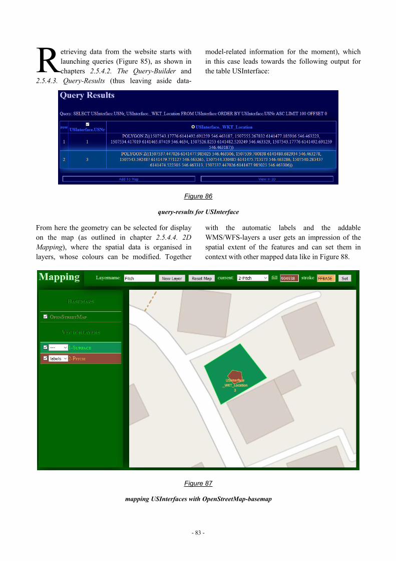
- 83 -
etrieving data from the website starts withlaunching queries (Figure 85), as shown inchapters 2.5.4.2. The Query-Builder and
2.5.4.3. Query-Results (thus leaving aside data-
model-related information for the moment), whichin this case leads towards the following output forthe table USInterface:
Figure 86
query-results for USInterface
From here the geometry can be selected for displayon the map (as outlined in chapter 2.5.4.4. 2DMapping), where the spatial data is organised inlayers, whose colours can be modified. Together
with the automatic labels and the addableWMS/WFS-layers a user gets an impression of thespatial extent of the features and can set them incontext with other mapped data like in Figure 88.
Figure 87
mapping USInterfaces with OpenStreetMap-basemap
R
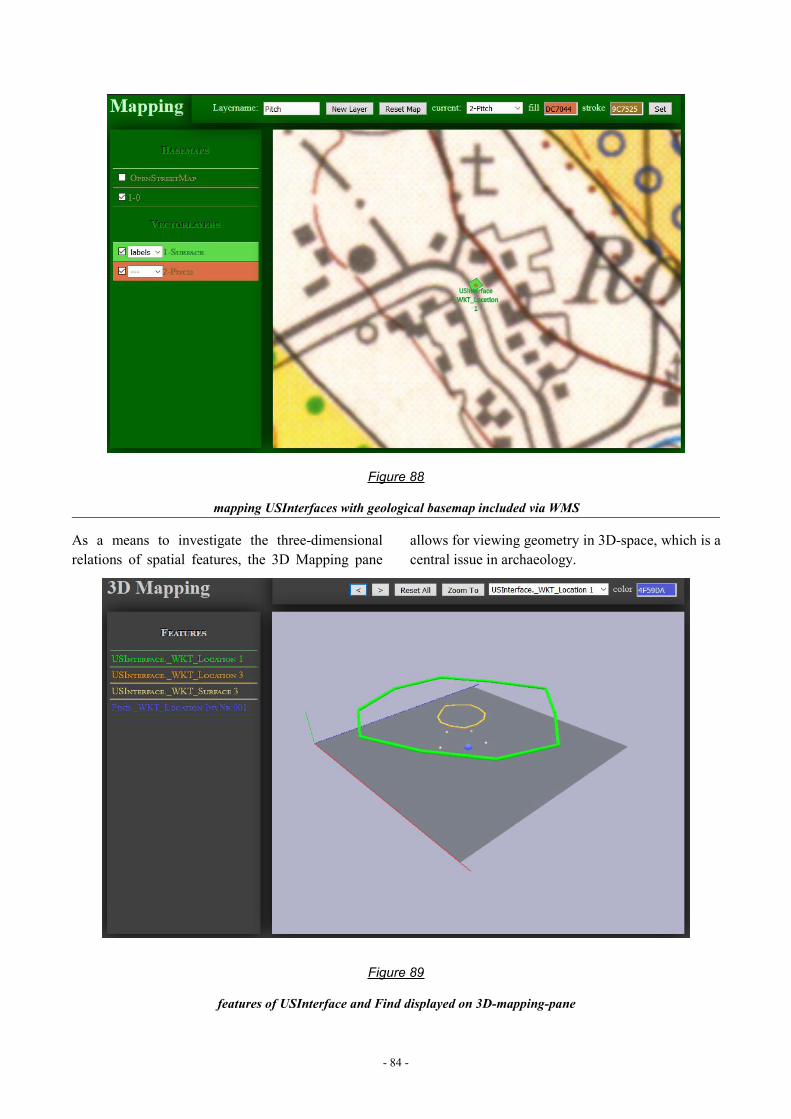
- 84 -
Figure 88
mapping USInterfaces with geological basemap included via WMS
As a means to investigate the three-dimensionalrelations of spatial features, the 3D Mapping pane
allows for viewing geometry in 3D-space, which is acentral issue in archaeology.
Figure 89
features of USInterface and Find displayed on 3D-mapping-pane
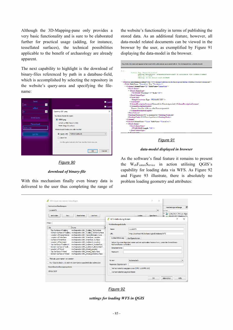
- 85 -
Although the 3D-Mapping-pane only provides avery basic functionality and is sure to be elaboratedfurther for practical usage (adding, for instance,tessellated surfaces), the technical possibilitiesapplicable to the benefit of archaeology are alreadyapparent.
The next capability to highlight is the download ofbinary-files referenced by path in a database-field,which is accomplished by selecting the repository inthe website’s query-area and specifying the file-name:
Figure 90
download of binary-file
With this mechanism finally even binary data isdelivered to the user thus completing the range of
the website’s functionality in terms of publishing thestored data. As an additional feature, however, alldata-model related documents can be viewed in thebrowser by the user, as exemplified by Figure 91displaying the data-model in the browser.
Figure 91
data-model displayed in browser
As the software’s final feature it remains to presentthe WebFeatureService in action utilising QGIS’scapability for loading data via WFS. As Figure 92and Figure 93 illustrate, there is absolutely noproblem loading geometry and attributes:
Figure 92
settings for loading WFS in QGIS
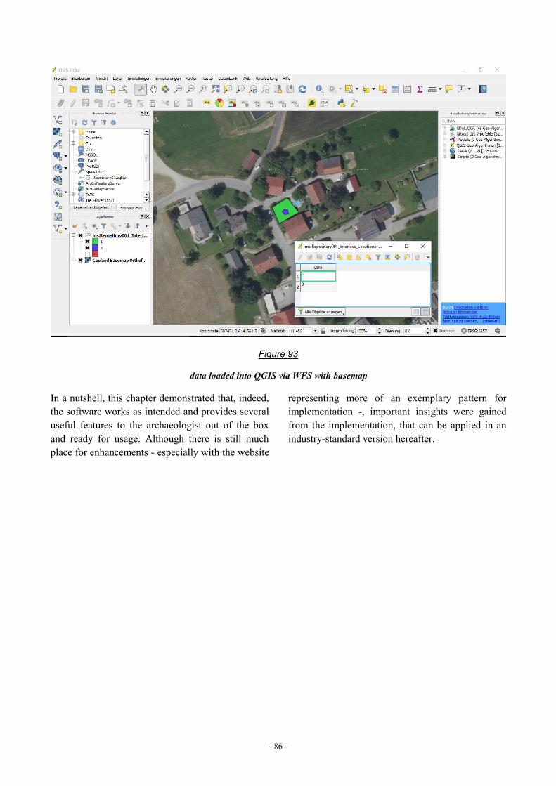
- 86 -
Figure 93
data loaded into QGIS via WFS with basemap
In a nutshell, this chapter demonstrated that, indeed,the software works as intended and provides severaluseful features to the archaeologist out of the boxand ready for usage. Although there is still muchplace for enhancements - especially with the website
representing more of an exemplary pattern forimplementation -, important insights were gainedfrom the implementation, that can be applied in anindustry-standard version hereafter.
- 87 -
4. DISCUSSIONfter having reviewed the results ofthis endeavour and gazed at theconsequent implications at variousoccasions (see chapters 2.4.6. Results,2.5.6. Results and 3. Results), it
remains to summarize the significance of this workin the light of the overall subject. Like outlined inthe introductory chapter (1. Introduction) thispaper’s goal is to develop and provide a method toovercome diversification of archaeological raw-dataoriginating from different excavations in Austria andstimulate data-integration, so as to allow forcollective data-analysis - especially in spatial terms.
The first thing to notice about the taken approach isthe act of transferring the guidelines for excavationsinto a data-model representing the key to collectivedata-integration. By this means each excavation-campaign no longer has to worry about coming upwith a strategy for structuring records, but cansimply resort to the data-model with its glossariesleading towards standardized records, that caneffortlessly be merged. For integration on a moreabstract level the data-model can additionally beenriched with mappings to an ontology.
Since the current guidelines - respectively the data-model - is mandatory for excavations in Austria andrequirements to data-management are more or lesssimilar in different campaigns, a programcollectively applied at the various excavations cannot only provide the desired functionality of data-input, -sharing,- analysis and -publishing thence
freeing archaeologists from assembling those toolsever anew , but - above all - guarantee the validity ofthe data in terms of the data-model. The developedsoftware is intended to take that very role, so as tolet archaeologists conduct excavation in the usualmanner, but to draw way more use from therecorded data. The benefit, therein, not only is to bethe expense-savings resulting from having aspecialised software on hand ready for data-storage,but the fact that the data is fed into an infrastructureautomatically packaging the records into database-files and publishing them via acknowledgedprotocols such as HTTP and WFS. Through that notonly do other archaeologists get access to digitalraw-data - a circumstance apparently hardlyprevailing -, but also the option arises to participatein Research Infrastructures. In these settings thearchaeologist is additionally enabled to obtain otherprojects’ data, in order to immediately set the owncampaign’s findings in context with the state ofresearch.
Two things, however, are to be stressed: Theimplementation of the website and the WFS -although fully functional - may be solved on otherservers in different ways, so that the strategy takenin this work is to be understood merely as asuggestion. Moreover, the software presented in thispaper is not intended to serve as centralized data-store in the scale of an institutional-level framework,but has its field of application mostly in the project-scale.
A
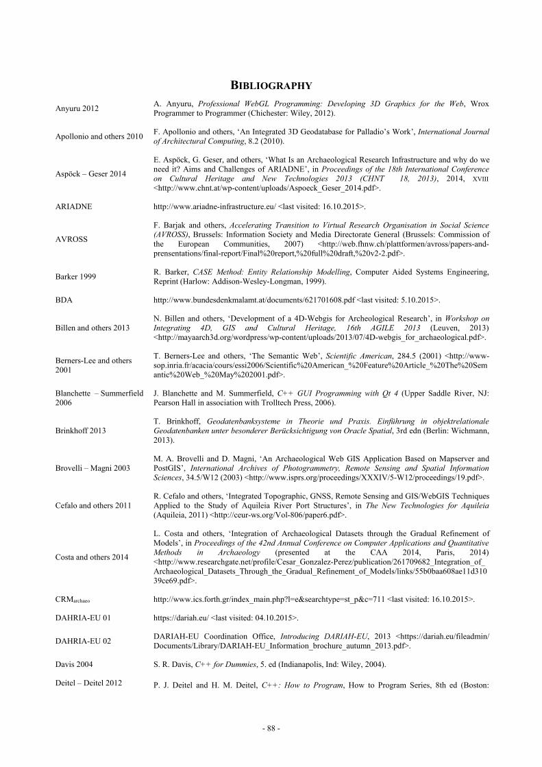
- 88 -
BIBLIOGRAPHY
Anyuru 2012 A. Anyuru, Professional WebGL Programming: Developing 3D Graphics for the Web, WroxProgrammer to Programmer (Chichester: Wiley, 2012).
Apollonio and others 2010 F. Apollonio and others, ‘An Integrated 3D Geodatabase for Palladio’s Work’, International Journalof Architectural Computing, 8.2 (2010).
Aspöck – Geser 2014
E. Aspöck, G. Geser, and others, ‘What Is an Archaeological Research Infrastructure and why do weneed it? Aims and Challenges of ARIADNE’, in Proceedings of the 18th International Conferenceon Cultural Heritage and New Technologies 2013 (CHNT 18, 2013), 2014, XVIII<http://www.chnt.at/wp-content/uploads/Aspoeck_Geser_2014.pdf>.
ARIADNE http://www.ariadne-infrastructure.eu/ <last visited: 16.10.2015>.
AVROSS
F. Barjak and others, Accelerating Transition to Virtual Research Organisation in Social Science(AVROSS), Brussels: Information Society and Media Directorate General (Brussels: Commission ofthe European Communities, 2007) <http://web.fhnw.ch/plattformen/avross/papers-and-prensentations/final-report/Final%20report,%20full%20draft,%20v2-2.pdf>.
Barker 1999 R. Barker, CASE Method: Entity Relationship Modelling, Computer Aided Systems Engineering,Reprint (Harlow: Addison-Wesley-Longman, 1999).
BDA http://www.bundesdenkmalamt.at/documents/621701608.pdf <last visited: 5.10.2015>.
Billen and others 2013N. Billen and others, ‘Development of a 4D-Webgis for Archeological Research’, in Workshop onIntegrating 4D, GIS and Cultural Heritage, 16th AGILE 2013 (Leuven, 2013)<http://mayaarch3d.org/wordpress/wp-content/uploads/2013/07/4D-webgis_for_archaeological.pdf>.
Berners-Lee and others2001
T. Berners-Lee and others, ‘The Semantic Web’, Scientific American, 284.5 (2001) <http://www-sop.inria.fr/acacia/cours/essi2006/Scientific%20American_%20Feature%20Article_%20The%20Semantic%20Web_%20May%202001.pdf>.
Blanchette – Summerfield2006
J. Blanchette and M. Summerfield, C++ GUI Programming with Qt 4 (Upper Saddle River, NJ:Pearson Hall in association with Trolltech Press, 2006).
Brinkhoff 2013T. Brinkhoff, Geodatenbanksysteme in Theorie und Praxis. Einführung in objektrelationaleGeodatenbanken unter besonderer Berücksichtigung von Oracle Spatial, 3rd edn (Berlin: Wichmann,2013).
Brovelli – Magni 2003M. A. Brovelli and D. Magni, ‘An Archaeological Web GIS Application Based on Mapserver andPostGIS’, International Archives of Photogrammetry, Remote Sensing and Spatial InformationSciences, 34.5/W12 (2003) <http://www.isprs.org/proceedings/XXXIV/5-W12/proceedings/19.pdf>.
Cefalo and others 2011R. Cefalo and others, ‘Integrated Topographic, GNSS, Remote Sensing and GIS/WebGIS TechniquesApplied to the Study of Aquileia River Port Structures’, in The New Technologies for Aquileia(Aquileia, 2011) <http://ceur-ws.org/Vol-806/paper6.pdf>.
Costa and others 2014
L. Costa and others, ‘Integration of Archaeological Datasets through the Gradual Refinement ofModels’, in Proceedings of the 42nd Annual Conference on Computer Applications and QuantitativeMethods in Archaeology (presented at the CAA 2014, Paris, 2014)<http://www.researchgate.net/profile/Cesar_Gonzalez-Perez/publication/261709682_Integration_of_Archaeological_Datasets_Through_the_Gradual_Refinement_of_Models/links/55b0baa608ae11d31039ce69.pdf>.
CRMarchaeo http://www.ics.forth.gr/index_main.php?l=e&searchtype=st_p&c=711 <last visited: 16.10.2015>.
DAHRIA-EU 01 https://dariah.eu/ <last visited: 04.10.2015>.
DAHRIA-EU 02 DARIAH-EU Coordination Office, Introducing DARIAH-EU, 2013 <https://dariah.eu/fileadmin/Documents/Library/DARIAH-EU_Information_brochure_autumn_2013.pdf>.
Davis 2004 S. R. Davis, C++ for Dummies, 5. ed (Indianapolis, Ind: Wiley, 2004).
Deitel – Deitel 2012 P. J. Deitel and H. M. Deitel, C++: How to Program, How to Program Series, 8th ed (Boston:
- 89 -
Prentice Hall, 2012).
Denkmalschutzgesetz https://www.ris.bka.gv.at/GeltendeFassung.wxe?Abfrage=Bundesnormen&Gesetzesnummer=10009184 <last visited: 13.05.2017>.
De Luca and others 2011 L. De Luca and others, ‘A Semantic-Based Platform for the Digital Analysis of ArchitecturalHeritage’, Computers & Graphics, 35.2 (2011).
DFG 2013
Vorschläge zur Sicherung guter wissenschaftlicher Praxis: Denkschrift ; Empfehlungen derKommission ‘Selbstkontrolle in der Wissenschaft’ = Proposals for Safeguarding Good ScientificPractice: Memorandum ; Recommendations of the Commission on Professional Self Regulation inScience, ed. by Deutsche Forschungsgemeinschaft, Erg. Aufl. (Weinheim: Wiley-VCH, 2013)<http://www.dfg.de/download/pdf/dfg_im_profil/reden_stellungnahmen/download/empfehlung_wiss_praxis_1310.pdf>.
Doerr and others 2004
M. Doerr and others, ‘Integration of Complementary Archaeological Sources’, in Beyond theArtefact – Digital Interpretation of the Past. Proceedings of the 32th International Conference onComputer Applications and Quantitative Methods in Archaeology (presented at the 32th InternationalConference on Computer Applications and Quantitative Methods in Archaeology, Prato, 2004)<https://www.ics.forth.gr/isl/publications/paperlink/doerr3_caa 2004.pdf>.
Dooley 2011 J. Dooley, Software Development and Professional Practice (New York, N.Y. : New York: Apress ;Distributed to the trade worldwide by Springer, 2011).
Eide and others 2011
O. Eide and others, ‘Encoding Cultural Heritage Information for the Semantic Web. Procedures forData Integration through CIDOC-CRM Mapping’, in EPOCH Conference on Open Digital CulturalHeritage Systems Conference: Congresso Rospigliosi, Rome 25-26 February 2008 (presented at theEPOCH Conference on Open Digital Cultural Heritage Systems Conference: Congresso Rospigliosi,Budapest: Archeolingua, 2011) <http://public-repository.epoch-net.org/rome/05%20Procedures%20Data%20Integration.pdf>.
ERA http://ec.europa.eu/research/era/index_en.htm <last visited: 04.10.2015>.
ERIC 01European Commission and Directorate General for Research, Legal Framework for a EuropeanResearch Infrastructure Consortium - ERIC: Practical Guidelines (Luxembourg: EUR-OP, 2010)<https://ec.europa.eu/research/infrastructures/pdf/eric_en.pdf>.
ERIC 02European Commission and Directorate General for Research, ERIC Practical Guidelines: LegalFramework for a European Research Infrastructure Consortium. (Luxembourg: Publications Office,2015) <http://dx.publications.europa.eu/10.2777/72348>.
ERIC 03 https://ec.europa.eu/research/infrastructures/index_en.cfm?pg=eric <last visited: 07.10.2015>.
ESFRI 01 http://ec.europa.eu/research/infrastructures/index_en.cfm?pg=esfri <last visited: 04.10.2015>.
ESFRI 02 http://ec.europa.eu/research/infrastructures/index_en.cfm?pg=esfri-roadmap <last visited:04.10.2015>.
ESFRI 03European Strategy Forum on Research Infrastructures, European Research Infrastructures withGlobal Impact (Brussels 2012). <http://www.copori.eu/_media/ESFRI_Brochure_210912_lowres.pdf>.
Flanagan 2011 D. Flanagan, JavaScript: The Definitive Guide, 6th ed (Beijing ; Sebastopol, CA: O’Reilly, 2011).
Gallo – Roberto 2012
P. Gallo and V. Roberto, ‘ANTEO: Sharing Archaeological Data on a WebGIS Platform’, inProceedings of the 2nd Workshop on The New Technologies for Aquileia (presented at the CEURWorkshop, Aquileia, 2012), CMXLVIII <http://citeseerx.ist.psu.edu/viewdoc/download?doi=10.1.1.416.9264&rep=rep1&type=pdf>.
Geser – Niccolucci 2013 G. Geser and F. Niccolucci, ‘Virtual Museums, Digital Reference Collections and E-ScienceEnvironments’, Uncommon Culture, 3.5/6 (2013).
Gilissen 2013
V. Gilissen, ‘Past the Opening: Building towards the Present, on-Going Dissemination of DutchArchaeological Data as Part of the DANS Archive’, in Conference Proceedings Opening the Past2013: Archaeology of the Future (presented at Opening the Past 2013: Archaeology of the Future,Pisa, 2013) <http://depot.knaw.nl/14882/1/Past_the_Opening-_building_towards_the_ present,_on-going_dissemination_of_Dutch_archaeological_data_as_part_of_the_DANS_ archive.pdf>.
- 90 -
Gough – Stallman 2005 B. Gough and R. M. Stallman, An Introduction to GCC: For the GNU Compilers Gcc and G++, ANetwork Theory Manual, 2. print. and updated (Bristol: Network Theory Ltd, 2005).
von Groote-Bidlingmaierand others 2015
C. von Groote-Bidlingmaier and others, ‘Interactive WebGIS for Archaeological Settlement PatternAnalysis–A Requirement Analysis’, in 27th International Cartographic Conference [and] 16thGeneral Assembly August 23-28, 2015, Rio de Janeiro, Brazil (presented at the 27th InternationalCartographic Conference, Rio de Janeiro, 2015) <http://icaci.org/files/documents/ICC_proceedings/ICC2015/papers/33/fullpaper/T33-1009_1428677 938.pdf>.
Henderson 2014C. Henderson, Mastering Geoserver: A Holistic Guide to Implementing a Robust, Scalable, andSecure Enterprise Geospatial Data Hosting System by Leveraging the Power of GeoServer(Birmingham: Packt Publ, 2014).
HERAS. Kaur-Pedersen and G. Kladakis, The HERA Survey on Infrastructural Research Facilities andPractices for the Humanities in Europe, 2006 <https://heranet.info/system/files/HERAJRPdocuments/Deliverables/d7.1.1_hera_survey_on_humanities_infrastructures.pdf>.
Herban – Vilceanu 2013
S. Herban and B. Vilceanu, ‘TLS and Digital Photogrammetry Studies in Cultural Heritage Domain’,in Recent Advances in Geodesy and Geomatics Engineering: Proceedings of the 1st EuropeanConference of Geodesy and Geomatics Engineering (GENG ’13) (presented at the 1st EuropeanConference of Geodesy and Geomatics Engineering, Antalya, 2013)<http://www.gf.uns.ac.rs/~zbornik/doc/NS2015.097.pdf>.
Hollosi 2012A. Hollosi, Von Geodaten bis NoSQL: leistungsstarke PHP-Anwendungen ; aktuelle Techniken undMethoden für Fortgeschrittene ; [MySQL 5.6, PostGIS 2.0, Redis 2.4, MongoDB 2.0, Varnish 3.0,Memcached 1.4] (München: Hanser, 2012).
Horton 2014 I. Horton, Beginning C++, The Expert’s Voice in C++ (California: Apress, 2014).
Iacovella – Youngblood2013
S. Iacovella and B. Youngblood, GeoServer Beginner’s Guide: Share and Edit Geospatial Data withThis Open Source Software Server, 1. publ (Birmingham: Packt Publ, 2013).
Isaksen and others 2009
L. Isaksen and others, ‘Linking Archaeological Data’, in Making History Interactive. Proceedings ofthe 37th International Conference on Computer Applications and Quantitative Methods inArchaeology (presented at the Making History Interactive. 37th International Conference onComputer Applications and Quantitative Methods in Archaeology, Williamsburg, 2009)<http://eprints.ecs.soton.ac.uk/18240>.
Josuttis 2012 N. M. Josuttis, The C++ Standard Library: A Tutorial and Reference, 2nd ed (Upper Saddle River,NJ: Addison-Wesley, 2012).
Karagiannis and others2012
K. N Vavliakis and others, ‘Semantic Web in Cultural Heritage after 2020’, in The Semantic Web --ISWC 2012 (presented at the 11th International Semantic Web Conference 2012, Boston, 2012), XI<http://issel.ee.auth.gr/wp-content/uploads/publications/sw2022_paper10.pdf>.
Kleuker 2011 S. Kleuker, Grundkurs Datenbankentwicklung: von der Anforderungsanalyse zur komplexenDatenbankanfrage, Studium, 2. Aufl (Wiesbaden: Vieweg + Teubner, 2011).
Mantegari – De Salvo2008
G. Mantegari and M. De Salvo, ‘Free and Open Source WebGIS Solutions for the PO-BASyN Project’, in Proceedings of the 36th CAA Conference (presented at the CAA 2008,Budapest, 2008), <http://proceedings.caaconference.org/files/2008/CD50_Mantegari_DeSalvo_CAA2008.pdf>.
Matsuda – Lea 2013 K. Matsuda and R. Lea, WebGL Programming Guide: Interactive 3D Graphics Programming withWebGL, Always Learning (Upper Saddle River, NJ: Addison-Wesley, 2013).
May and others 2011
K. May and others, ‘Semantic Technologies Enhancing Links and Linked Data for ArchaeologicalResources’, in Revive the Past. Computer Applications and Quantitative Methods in Archaeology(CAA). Proceedings of the 39th International Conference (presented at the CAA, Beijing, 2011)<http://proceedings.caaconference.org/files/2011/29_May_et_al_CAA2011.pdf>.
Meyer and others 2006
E. Meyer and others, ‘Integration of Heterogeneous Cultural Heritage Data in a Web-BasedInformation System: A Case Study from Vianden Castle, Luxembourg’, in Digital Discovery.Exploring New Frontiers in Human Heritage. Proceedings of the 34th International Conference onComputer Applications and Quantitative Methods in Archaeology (presented at 34th AnnualConference on Computer Applications and Quantitative Methods in Archaeology, Fargo, 2006)
- 91 -
<https://halshs.archives-ouvertes.fr/halshs-00280680>.
Möller 2001 C. Möller, ‘Bodenkundliche Feldmethoden in Der Archäologie’, ArchäologischesKorrespondenzblatt, 6.1 (2001) <http://www.grabung-ev.de/grabung_aktuell/GA14-03.pdf>.
Nedelcu 2013 C. Nedelcu, Nginx HTTP Server: Adopt Nginx for Your Web Applications to Make the Most of YourInfrastructure and Serve Pages Faster than Ever, 2. Aufl (Birmingham: Packt Publ, 2013).
Niccolucci – Richards2013
F. Niccolucci and J. D Richards, ‘ARIADNE: Advanced Research Infrastructures for ArchaeologicalDataset Networking in Europe’, International Journal of Humanities and Arts Computing, 7.1-2(2013) <http://e-a-a.org/TEA/archive/TEA_39_SUMMER_2013/rep1_39.pdf>.
Niven - Wright 2014K. Niven and H. Wright, Initial Report on Good Practices, 2014 <http://www.ariadne-infrastructure.eu/content/download/4250/24576/file/ARIADNE_D4.4._Initial%20_Report_Good_Practices.pdf>.
Nixon 2014 R. Nixon, Learning PHP, MySQL, JavaScript, CSS & HTML5: A Step-by-Step Guide to CreatingDynamic Websites (O’Reilly Media, Inc., 2014).
Owens 2006 M. Owens, The Definitive Guide to SQLite (New York: Apress, 2006).
Parisi 2014 T. Parisi, Programming 3D Applications with HTML5 and WebGL, First edition (Beijing: O’Reilly,2014).
Platzer – Leonhardt 2005 W. Platzer and H. Leonhardt, Taschenatlas Anatomie (Georg Thieme Verlag, 2005), I.
Puhl 2015J. Puhl and others, ‘Diskussion und Definition eines Research Data LifeCycle für die digitalenGeisteswissenschaften’, DARIAH-DE Working Papers, 11 (2015) <http://webdoc.sub.gwdg.de/pub/mon/dariah-de/dwp-2015-11.pdf>.
Reibold 2013 H. Reibold, XAMPP 1.8 Kompakt: Das Anwenderhandbuch (Brain-Media, 2013).
Richards 2012 J. Richards, ‘Digital Infrastructures for Archaeological Research: A European Perspective’, CSANewsletter, 25.2 (2012) <http://csanet.org/newsletter/fall12/nlf1202.html>.
Richards-Rissetto andothers 2010
H. Richards-Rissetto and others, ‘Kinect and 3D GIS in Archaeology’, in Anthropology FacultyPublications (presented at the 18th International Conference on Virtual Systems and Multimedia(VSMM), Milan: IEEE, 2012) <http://ieeexplore.ieee.org/xpls/abs_all.jsp?arnumber=6365942>.
Riding the Wave 2010Riding the Wave. How Europe Can Gain from the Rising Tide of Scientific Data. Final Report of theEuropean High-Level Expert Group on Scientific Data, A Submission to the European Commission,2010 <http://cordis.europa.eu/fp7/ict/e-infrastructure/docs/hlg-sdi-report.pdf>.
Scianna – Villa 2011 A. Scianna and B. Villa, ‘GIS Applications in Archaeology’, Archeologia E Calcolatori, 22 (2011)<http://eprints.bice.rm.cnr.it/4245/>.
Sebillo and others 2003 M. Sebillo and others, ‘A WebGIS for Promoting Archaeological Assets’, Archives and MuseumInformatics, 2003 <http://www.archimuse.com/publishing/ichim03/068C.pdf>.
Semeraro 2007G. Semeraro, ‘LandLab Project and Archaeology On-Line. Web-Based Systems for the Study ofSettlement Patterns and Excavation Data in Classical Archaeology’, Archeologia e Calcolatori, 18(2007) <http://eprints.bice.rm.cnr.it/1076/>.
Stroustrup 2013 B. Stroustrup, The C++ Programming Language, Fourth edition (Upper Saddle River, NJ: Addison-Wesley, 2013).
STELLAR http://hypermedia.research.southwales.ac.uk/kos/stellar/ <last visited: 16.10.2015>.
Szász and others 2006
B. Szász and others, ‘Cultural Heritage on the Semantic Web – the Museum24 Project’, in DigitalSemantic Content across Cultures Conference (presented at the Digital Semantic Content acrossCultures Conference, Paris, 2006) <http://www.seco.tkk.fi/events/2006/2006-05-04-websemantique/presentations/articles/Szasz-museum24Paris.pdf>.
Tatroe and others 2013 K. Tatroe, Peter MacIntyre, and Rasmus Lerdorf, Programming Php (O’Reilly Media, Inc., 2013).
ThreeJS 2013 J. Dirksen, Learning Three.Js: The JavaScript 3D Library for WebGL: Create and Animate Stunning3D Graphics Using the Open Source Three.js JavaScript Library (Birmingham: Packt Publishing

- 92 -
Limited, 2013).
Tsalgatidou –Pilioura2002
A. Tsalgatidou and T. Pilioura, ‘An Overview of Standards and Related Technology in WebServices’, Distributed and Parallel Databases, 12.2–3 (2002).
UML Glasklar 2012 C. Rupp, S. Queins and die SOPHISTEN, UML 2 Glasklar (München: Carl Hanser Verlag, 2012).
Unsworth 2006J. Unsworth, Our Cultural Commonwealth: The Report of the American Council of Learned SocietiesCommission on Cyberinfrastructure for the Humanities and Social Sciences (ACLS: New York,2006) <https://www.ideals.illinois.edu/handle/2142/189>.
Van der Vlist 2002 E. Van der Vlist, XML Schema. The W3C’s Object-Oriented Descriptions for XML, 1. ed (O’Reilly,2002) <http://ebooks.elportal.info/O'Reilly%20-%20Xml%20Schema,%201st%20 Edition.pdf>.
Vonhoegen 2013 H. Vonhoegen, XML für Eilige (Köln: Helmut Vonhoegen, 2013) <http://nbn-resolving.de/urn:nbn:de:101:1-201309042794>.
Williams 2012 A. Williams, C++ Concurrency in Action: Practical Multithreading (Shelter Island, NY: Manning,2012).
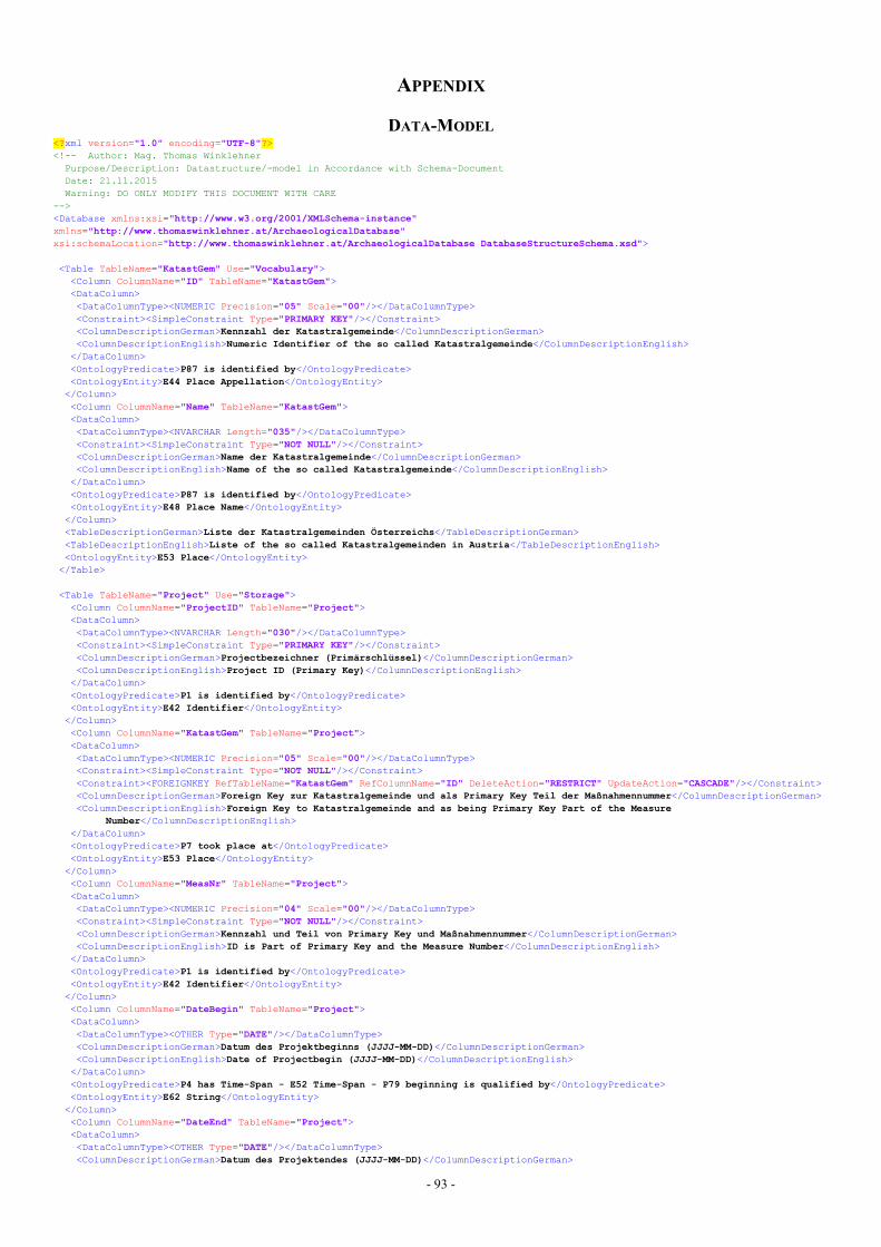
- 93 -
APPENDIX
DATA-MODEL<?xml version="1.0" encoding="UTF-8"?><!-- Author: Mag. Thomas WinklehnerPurpose/Description: Datastructure/-model in Accordance with Schema-DocumentDate: 21.11.2015Warning: DO ONLY MODIFY THIS DOCUMENT WITH CARE
--><Database xmlns:xsi="http://www.w3.org/2001/XMLSchema-instance"xmlns="http://www.thomaswinklehner.at/ArchaeologicalDatabase"xsi:schemaLocation="http://www.thomaswinklehner.at/ArchaeologicalDatabase DatabaseStructureSchema.xsd">
<Table TableName="KatastGem" Use="Vocabulary"><Column ColumnName="ID" TableName="KatastGem"><DataColumn><DataColumnType><NUMERIC Precision="05" Scale="00"/></DataColumnType><Constraint><SimpleConstraint Type="PRIMARY KEY"/></Constraint><ColumnDescriptionGerman>Kennzahl der Katastralgemeinde</ColumnDescriptionGerman><ColumnDescriptionEnglish>Numeric Identifier of the so called Katastralgemeinde</ColumnDescriptionEnglish>
</DataColumn><OntologyPredicate>P87 is identified by</OntologyPredicate><OntologyEntity>E44 Place Appellation</OntologyEntity></Column><Column ColumnName="Name" TableName="KatastGem"><DataColumn><DataColumnType><NVARCHAR Length="035"/></DataColumnType><Constraint><SimpleConstraint Type="NOT NULL"/></Constraint><ColumnDescriptionGerman>Name der Katastralgemeinde</ColumnDescriptionGerman><ColumnDescriptionEnglish>Name of the so called Katastralgemeinde</ColumnDescriptionEnglish>
</DataColumn><OntologyPredicate>P87 is identified by</OntologyPredicate><OntologyEntity>E48 Place Name</OntologyEntity></Column><TableDescriptionGerman>Liste der Katastralgemeinden Österreichs</TableDescriptionGerman><TableDescriptionEnglish>Liste of the so called Katastralgemeinden in Austria</TableDescriptionEnglish><OntologyEntity>E53 Place</OntologyEntity>
</Table>
<Table TableName="Project" Use="Storage"><Column ColumnName="ProjectID" TableName="Project"><DataColumn><DataColumnType><NVARCHAR Length="030"/></DataColumnType><Constraint><SimpleConstraint Type="PRIMARY KEY"/></Constraint><ColumnDescriptionGerman>Projectbezeichner (Primärschlüssel)</ColumnDescriptionGerman><ColumnDescriptionEnglish>Project ID (Primary Key)</ColumnDescriptionEnglish>
</DataColumn><OntologyPredicate>P1 is identified by</OntologyPredicate><OntologyEntity>E42 Identifier</OntologyEntity></Column><Column ColumnName="KatastGem" TableName="Project"><DataColumn><DataColumnType><NUMERIC Precision="05" Scale="00"/></DataColumnType><Constraint><SimpleConstraint Type="NOT NULL"/></Constraint><Constraint><FOREIGNKEY RefTableName="KatastGem" RefColumnName="ID" DeleteAction="RESTRICT" UpdateAction="CASCADE"/></Constraint><ColumnDescriptionGerman>Foreign Key zur Katastralgemeinde und als Primary Key Teil der Maßnahmennummer</ColumnDescriptionGerman><ColumnDescriptionEnglish>Foreign Key to Katastralgemeinde and as being Primary Key Part of the Measure
Number</ColumnDescriptionEnglish></DataColumn><OntologyPredicate>P7 took place at</OntologyPredicate><OntologyEntity>E53 Place</OntologyEntity></Column><Column ColumnName="MeasNr" TableName="Project"><DataColumn><DataColumnType><NUMERIC Precision="04" Scale="00"/></DataColumnType><Constraint><SimpleConstraint Type="NOT NULL"/></Constraint><ColumnDescriptionGerman>Kennzahl und Teil von Primary Key und Maßnahmennummer</ColumnDescriptionGerman><ColumnDescriptionEnglish>ID is Part of Primary Key and the Measure Number</ColumnDescriptionEnglish>
</DataColumn><OntologyPredicate>P1 is identified by</OntologyPredicate><OntologyEntity>E42 Identifier</OntologyEntity></Column><Column ColumnName="DateBegin" TableName="Project"><DataColumn><DataColumnType><OTHER Type="DATE"/></DataColumnType><ColumnDescriptionGerman>Datum des Projektbeginns (JJJJ-MM-DD)</ColumnDescriptionGerman><ColumnDescriptionEnglish>Date of Projectbegin (JJJJ-MM-DD)</ColumnDescriptionEnglish>
</DataColumn><OntologyPredicate>P4 has Time-Span - E52 Time-Span - P79 beginning is qualified by</OntologyPredicate><OntologyEntity>E62 String</OntologyEntity></Column><Column ColumnName="DateEnd" TableName="Project"><DataColumn><DataColumnType><OTHER Type="DATE"/></DataColumnType><ColumnDescriptionGerman>Datum des Projektendes (JJJJ-MM-DD)</ColumnDescriptionGerman>
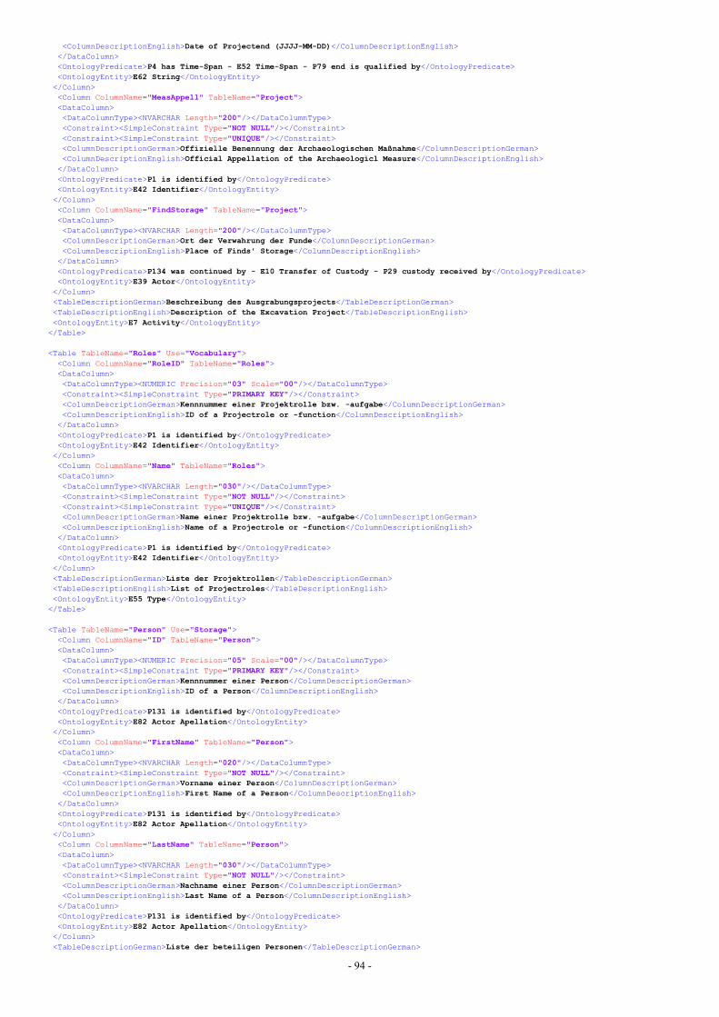
- 94 -
<ColumnDescriptionEnglish>Date of Projectend (JJJJ-MM-DD)</ColumnDescriptionEnglish></DataColumn><OntologyPredicate>P4 has Time-Span - E52 Time-Span - P79 end is qualified by</OntologyPredicate><OntologyEntity>E62 String</OntologyEntity></Column><Column ColumnName="MeasAppell" TableName="Project"><DataColumn><DataColumnType><NVARCHAR Length="200"/></DataColumnType><Constraint><SimpleConstraint Type="NOT NULL"/></Constraint><Constraint><SimpleConstraint Type="UNIQUE"/></Constraint><ColumnDescriptionGerman>Offizielle Benennung der Archaeologischen Maßnahme</ColumnDescriptionGerman><ColumnDescriptionEnglish>Official Appellation of the Archaeologicl Measure</ColumnDescriptionEnglish>
</DataColumn><OntologyPredicate>P1 is identified by</OntologyPredicate><OntologyEntity>E42 Identifier</OntologyEntity></Column><Column ColumnName="FindStorage" TableName="Project"><DataColumn><DataColumnType><NVARCHAR Length="200"/></DataColumnType><ColumnDescriptionGerman>Ort der Verwahrung der Funde</ColumnDescriptionGerman><ColumnDescriptionEnglish>Place of Finds' Storage</ColumnDescriptionEnglish>
</DataColumn><OntologyPredicate>P134 was continued by - E10 Transfer of Custody - P29 custody received by</OntologyPredicate><OntologyEntity>E39 Actor</OntologyEntity></Column><TableDescriptionGerman>Beschreibung des Ausgrabungsprojects</TableDescriptionGerman><TableDescriptionEnglish>Description of the Excavation Project</TableDescriptionEnglish><OntologyEntity>E7 Activity</OntologyEntity>
</Table>
<Table TableName="Roles" Use="Vocabulary"><Column ColumnName="RoleID" TableName="Roles"><DataColumn><DataColumnType><NUMERIC Precision="03" Scale="00"/></DataColumnType><Constraint><SimpleConstraint Type="PRIMARY KEY"/></Constraint><ColumnDescriptionGerman>Kennnummer einer Projektrolle bzw. -aufgabe</ColumnDescriptionGerman><ColumnDescriptionEnglish>ID of a Projectrole or -function</ColumnDescriptionEnglish>
</DataColumn><OntologyPredicate>P1 is identified by</OntologyPredicate><OntologyEntity>E42 Identifier</OntologyEntity></Column><Column ColumnName="Name" TableName="Roles"><DataColumn><DataColumnType><NVARCHAR Length="030"/></DataColumnType><Constraint><SimpleConstraint Type="NOT NULL"/></Constraint><Constraint><SimpleConstraint Type="UNIQUE"/></Constraint><ColumnDescriptionGerman>Name einer Projektrolle bzw. -aufgabe</ColumnDescriptionGerman><ColumnDescriptionEnglish>Name of a Projectrole or -function</ColumnDescriptionEnglish>
</DataColumn><OntologyPredicate>P1 is identified by</OntologyPredicate><OntologyEntity>E42 Identifier</OntologyEntity></Column><TableDescriptionGerman>Liste der Projektrollen</TableDescriptionGerman><TableDescriptionEnglish>List of Projectroles</TableDescriptionEnglish><OntologyEntity>E55 Type</OntologyEntity>
</Table>
<Table TableName="Person" Use="Storage"><Column ColumnName="ID" TableName="Person"><DataColumn><DataColumnType><NUMERIC Precision="05" Scale="00"/></DataColumnType><Constraint><SimpleConstraint Type="PRIMARY KEY"/></Constraint><ColumnDescriptionGerman>Kennnummer einer Person</ColumnDescriptionGerman><ColumnDescriptionEnglish>ID of a Person</ColumnDescriptionEnglish>
</DataColumn><OntologyPredicate>P131 is identified by</OntologyPredicate><OntologyEntity>E82 Actor Apellation</OntologyEntity></Column><Column ColumnName="FirstName" TableName="Person"><DataColumn><DataColumnType><NVARCHAR Length="020"/></DataColumnType><Constraint><SimpleConstraint Type="NOT NULL"/></Constraint><ColumnDescriptionGerman>Vorname einer Person</ColumnDescriptionGerman><ColumnDescriptionEnglish>First Name of a Person</ColumnDescriptionEnglish>
</DataColumn><OntologyPredicate>P131 is identified by</OntologyPredicate><OntologyEntity>E82 Actor Apellation</OntologyEntity></Column><Column ColumnName="LastName" TableName="Person"><DataColumn><DataColumnType><NVARCHAR Length="030"/></DataColumnType><Constraint><SimpleConstraint Type="NOT NULL"/></Constraint><ColumnDescriptionGerman>Nachname einer Person</ColumnDescriptionGerman><ColumnDescriptionEnglish>Last Name of a Person</ColumnDescriptionEnglish>
</DataColumn><OntologyPredicate>P131 is identified by</OntologyPredicate><OntologyEntity>E82 Actor Apellation</OntologyEntity></Column><TableDescriptionGerman>Liste der beteiligen Personen</TableDescriptionGerman>
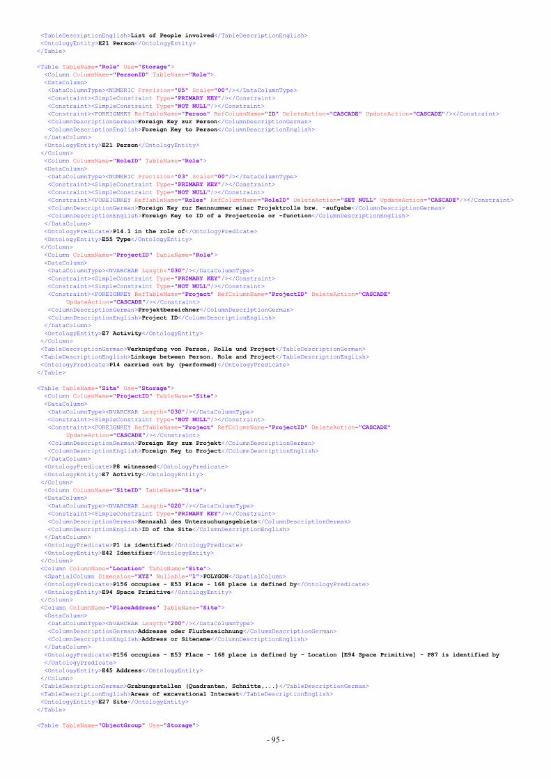
- 95 -
<TableDescriptionEnglish>List of People involved</TableDescriptionEnglish><OntologyEntity>E21 Person</OntologyEntity>
</Table>
<Table TableName="Role" Use="Storage"><Column ColumnName="PersonID" TableName="Role"><DataColumn><DataColumnType><NUMERIC Precision="05" Scale="00"/></DataColumnType><Constraint><SimpleConstraint Type="PRIMARY KEY"/></Constraint><Constraint><SimpleConstraint Type="NOT NULL"/></Constraint><Constraint><FOREIGNKEY RefTableName="Person" RefColumnName="ID" DeleteAction="CASCADE" UpdateAction="CASCADE"/></Constraint><ColumnDescriptionGerman>Foreign Key zur Person</ColumnDescriptionGerman><ColumnDescriptionEnglish>Foreign Key to Person</ColumnDescriptionEnglish>
</DataColumn><OntologyEntity>E21 Person</OntologyEntity></Column><Column ColumnName="RoleID" TableName="Role"><DataColumn><DataColumnType><NUMERIC Precision="03" Scale="00"/></DataColumnType><Constraint><SimpleConstraint Type="PRIMARY KEY"/></Constraint><Constraint><SimpleConstraint Type="NOT NULL"/></Constraint><Constraint><FOREIGNKEY RefTableName="Roles" RefColumnName="RoleID" DeleteAction="SET NULL" UpdateAction="CASCADE"/></Constraint><ColumnDescriptionGerman>Foreign Key zur Kennnummer einer Projektrolle bzw. -aufgabe</ColumnDescriptionGerman><ColumnDescriptionEnglish>Foreign Key to ID of a Projectrole or -function</ColumnDescriptionEnglish>
</DataColumn><OntologyPredicate>P14.1 in the role of</OntologyPredicate><OntologyEntity>E55 Type</OntologyEntity></Column><Column ColumnName="ProjectID" TableName="Role"><DataColumn><DataColumnType><NVARCHAR Length="030"/></DataColumnType><Constraint><SimpleConstraint Type="PRIMARY KEY"/></Constraint><Constraint><SimpleConstraint Type="NOT NULL"/></Constraint><Constraint><FOREIGNKEY RefTableName="Project" RefColumnName="ProjectID" DeleteAction="CASCADE"
UpdateAction="CASCADE"/></Constraint><ColumnDescriptionGerman>Projektbezeichner</ColumnDescriptionGerman><ColumnDescriptionEnglish>Project ID</ColumnDescriptionEnglish>
</DataColumn><OntologyEntity>E7 Activity</OntologyEntity></Column><TableDescriptionGerman>Verknüpfung von Person, Rolle und Project</TableDescriptionGerman><TableDescriptionEnglish>Linkage between Person, Role and Project</TableDescriptionEnglish><OntologyPredicate>P14 carried out by (performed)</OntologyPredicate>
</Table>
<Table TableName="Site" Use="Storage"><Column ColumnName="ProjectID" TableName="Site"><DataColumn><DataColumnType><NVARCHAR Length="030"/></DataColumnType><Constraint><SimpleConstraint Type="NOT NULL"/></Constraint><Constraint><FOREIGNKEY RefTableName="Project" RefColumnName="ProjectID" DeleteAction="CASCADE"
UpdateAction="CASCADE"/></Constraint><ColumnDescriptionGerman>Foreign Key zum Projekt</ColumnDescriptionGerman><ColumnDescriptionEnglish>Foreign Key to Project</ColumnDescriptionEnglish>
</DataColumn><OntologyPredicate>P8 witnessed</OntologyPredicate><OntologyEntity>E7 Activity</OntologyEntity></Column><Column ColumnName="SiteID" TableName="Site"><DataColumn><DataColumnType><NVARCHAR Length="020"/></DataColumnType><Constraint><SimpleConstraint Type="PRIMARY KEY"/></Constraint><ColumnDescriptionGerman>Kennzahl des Untersuchungsgebiets</ColumnDescriptionGerman><ColumnDescriptionEnglish>ID of the Site</ColumnDescriptionEnglish>
</DataColumn><OntologyPredicate>P1 is identified</OntologyPredicate><OntologyEntity>E42 Identifier</OntologyEntity></Column><Column ColumnName="Location" TableName="Site"><SpatialColumn Dimension="XYZ" Nullable="1">POLYGON</SpatialColumn><OntologyPredicate>P156 occupies - E53 Place - 168 place is defined by</OntologyPredicate><OntologyEntity>E94 Space Primitive</OntologyEntity></Column><Column ColumnName="PlaceAddress" TableName="Site"><DataColumn><DataColumnType><NVARCHAR Length="200"/></DataColumnType><ColumnDescriptionGerman>Addresse oder Flurbezeichnung</ColumnDescriptionGerman><ColumnDescriptionEnglish>Address or Sitename</ColumnDescriptionEnglish>
</DataColumn><OntologyPredicate>P156 occupies - E53 Place - 168 place is defined by - Location [E94 Space Primitive] - P87 is identified by</OntologyPredicate><OntologyEntity>E45 Address</OntologyEntity></Column><TableDescriptionGerman>Grabungsstellen (Quadranten, Schnitte,...)</TableDescriptionGerman><TableDescriptionEnglish>Areas of excavational Interest</TableDescriptionEnglish><OntologyEntity>E27 Site</OntologyEntity>
</Table>
<Table TableName="ObjectGroup" Use="Storage">
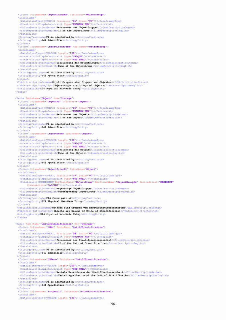
- 96 -
<Column ColumnName="ObjectGroupNr" TableName="ObjectGroup"><DataColumn><DataColumnType><NUMERIC Precision="05" Scale="00"/></DataColumnType><Constraint><SimpleConstraint Type="PRIMARY KEY"/></Constraint><ColumnDescriptionGerman>Kennnummer der ObjektGruppe</ColumnDescriptionGerman><ColumnDescriptionEnglish>ID of the ObjectGroup</ColumnDescriptionEnglish>
</DataColumn><OntologyPredicate>P1 is identified by</OntologyPredicate><OntologyEntity>E42 Identifier</OntologyEntity></Column><Column ColumnName="ObjectGroupTerm" TableName="ObjectGroup"><DataColumn><DataColumnType><NVARCHAR Length="100"/></DataColumnType><Constraint><SimpleConstraint Type="UNIQUE"/></Constraint><Constraint><SimpleConstraint Type="NOT NULL"/></Constraint><ColumnDescriptionGerman>Bezeichnung der ObjektsGruppe</ColumnDescriptionGerman><ColumnDescriptionEnglish>Name of the ObjectGroup</ColumnDescriptionEnglish>
</DataColumn><OntologyPredicate>P1 is identified by</OntologyPredicate><OntologyEntity>E41 Appellation</OntologyEntity></Column><TableDescriptionGerman>Objekt Gruppen sind Gruppen von Objekten</TableDescriptionGerman><TableDescriptionEnglish>ObjectGroups are Groups of Objects</TableDescriptionEnglish><OntologyEntity>E24 Physical Man-Made Thing</OntologyEntity>
</Table>
<Table TableName="Object" Use="Storage"><Column ColumnName="ObjectNr" TableName="Object"><DataColumn><DataColumnType><NUMERIC Precision="05" Scale="00"/></DataColumnType><Constraint><SimpleConstraint Type="PRIMARY KEY"/></Constraint><ColumnDescriptionGerman>Kennnummer des Objekts</ColumnDescriptionGerman><ColumnDescriptionEnglish>ID of the Object</ColumnDescriptionEnglish>
</DataColumn><OntologyPredicate>P1 is identified by</OntologyPredicate><OntologyEntity>E42 Identifier</OntologyEntity></Column><Column ColumnName="ObjectTerm" TableName="Object"><DataColumn><DataColumnType><NVARCHAR Length="100"/></DataColumnType><Constraint><SimpleConstraint Type="UNIQUE"/></Constraint><Constraint><SimpleConstraint Type="NOT NULL"/></Constraint><ColumnDescriptionGerman>Bezeichnung des Objekts</ColumnDescriptionGerman><ColumnDescriptionEnglish>Name of the Object</ColumnDescriptionEnglish>
</DataColumn><OntologyPredicate>P1 is identified by</OntologyPredicate><OntologyEntity>E41 Appellation</OntologyEntity></Column><Column ColumnName="ObjectGroupNr" TableName="Object"><DataColumn><DataColumnType><NUMERIC Precision="05" Scale="00"/></DataColumnType><Constraint><SimpleConstraint Type="NOT NULL"/></Constraint><Constraint><FOREIGNKEY RefTableName="ObjectGroup" RefColumnName="ObjectGroupNr" DeleteAction="RESTRICT"
UpdateAction="CASCADE"/></Constraint><ColumnDescriptionGerman>zugehörige ObjektGruppe</ColumnDescriptionGerman><ColumnDescriptionEnglish>corresponding ObjectGroup</ColumnDescriptionEnglish>
</DataColumn><OntologyPredicate>P46 forms part of</OntologyPredicate><OntologyEntity>E24 Physical Man-Made Thing</OntologyEntity></Column><TableDescriptionGerman>Objekte sind Gruppen von Stratifikationseinheiten</TableDescriptionGerman><TableDescriptionEnglish>Objects are Groups of Units of Stratification</TableDescriptionEnglish><OntologyEntity>E24 Physical Man-Made Thing</OntologyEntity>
</Table>
<Table TableName="UnitOfStratification" Use="Storage"><Column ColumnName="USNr" TableName="UnitOfStratification"><DataColumn><DataColumnType><NUMERIC Precision="06" Scale="00"/></DataColumnType><Constraint><SimpleConstraint Type="PRIMARY KEY"/></Constraint><ColumnDescriptionGerman>Kennnummer der Stratifikationseinheit</ColumnDescriptionGerman><ColumnDescriptionEnglish>ID of the Unit of Stratification</ColumnDescriptionEnglish>
</DataColumn><OntologyPredicate>P1 is identified by</OntologyPredicate><OntologyEntity>E42 Identifier</OntologyEntity></Column><Column ColumnName="USTerm" TableName="UnitOfStratification"><DataColumn><DataColumnType><NVARCHAR Length="200"/></DataColumnType><Constraint><SimpleConstraint Type="NOT NULL"/></Constraint><ColumnDescriptionGerman>Verbale Bezeichnung der Statifikationseinheit</ColumnDescriptionGerman><ColumnDescriptionEnglish>Verbal Appellation of the Unit of Stratification</ColumnDescriptionEnglish>
</DataColumn><OntologyPredicate>P1 is identified by</OntologyPredicate><OntologyEntity>E41 Appellation</OntologyEntity></Column><Column ColumnName="ProjectID" TableName="UnitOfStratification"><DataColumn><DataColumnType><NVARCHAR Length="030"/></DataColumnType>
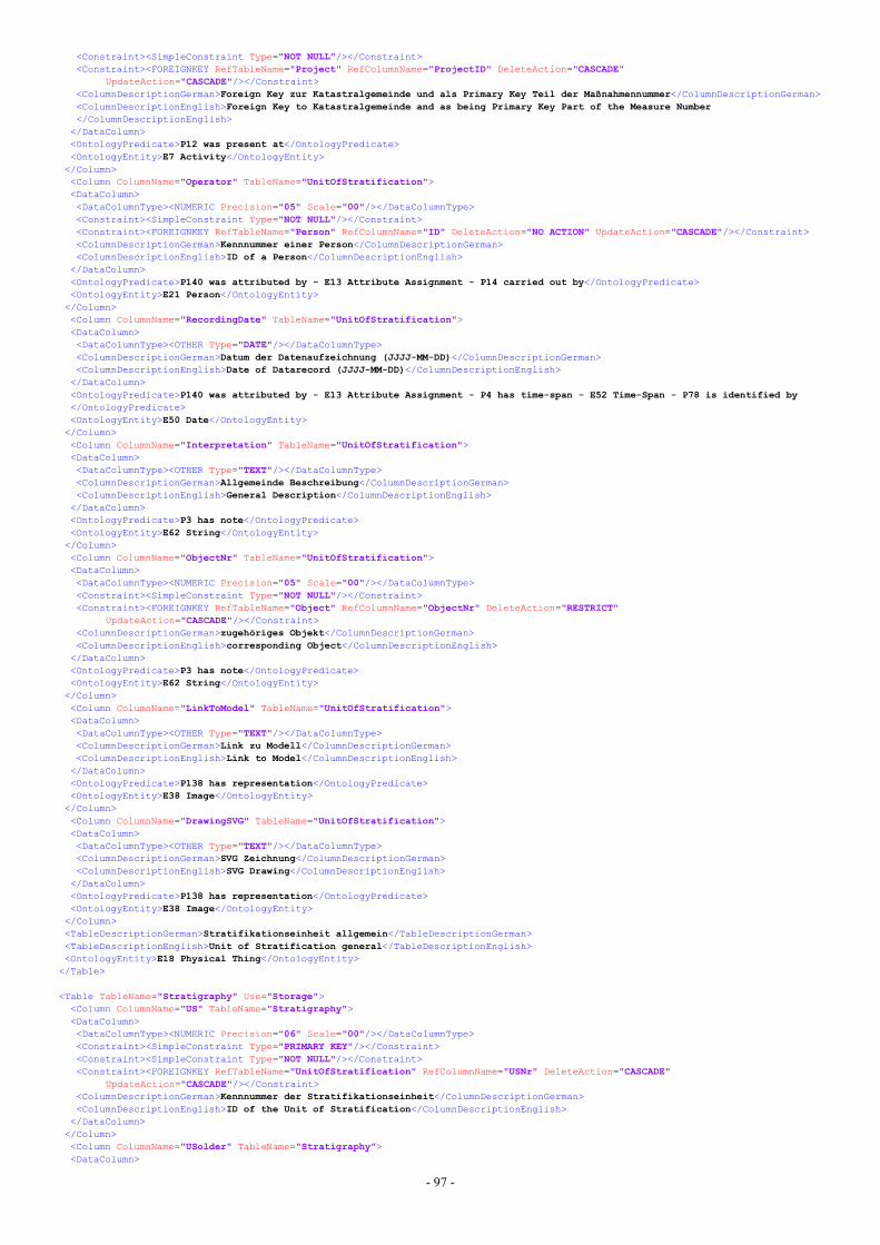
- 97 -
<Constraint><SimpleConstraint Type="NOT NULL"/></Constraint><Constraint><FOREIGNKEY RefTableName="Project" RefColumnName="ProjectID" DeleteAction="CASCADE"
UpdateAction="CASCADE"/></Constraint><ColumnDescriptionGerman>Foreign Key zur Katastralgemeinde und als Primary Key Teil der Maßnahmennummer</ColumnDescriptionGerman><ColumnDescriptionEnglish>Foreign Key to Katastralgemeinde and as being Primary Key Part of the Measure Number</ColumnDescriptionEnglish>
</DataColumn><OntologyPredicate>P12 was present at</OntologyPredicate><OntologyEntity>E7 Activity</OntologyEntity></Column><Column ColumnName="Operator" TableName="UnitOfStratification"><DataColumn><DataColumnType><NUMERIC Precision="05" Scale="00"/></DataColumnType><Constraint><SimpleConstraint Type="NOT NULL"/></Constraint><Constraint><FOREIGNKEY RefTableName="Person" RefColumnName="ID" DeleteAction="NO ACTION" UpdateAction="CASCADE"/></Constraint><ColumnDescriptionGerman>Kennnummer einer Person</ColumnDescriptionGerman><ColumnDescriptionEnglish>ID of a Person</ColumnDescriptionEnglish>
</DataColumn><OntologyPredicate>P140 was attributed by - E13 Attribute Assignment - P14 carried out by</OntologyPredicate><OntologyEntity>E21 Person</OntologyEntity></Column><Column ColumnName="RecordingDate" TableName="UnitOfStratification"><DataColumn><DataColumnType><OTHER Type="DATE"/></DataColumnType><ColumnDescriptionGerman>Datum der Datenaufzeichnung (JJJJ-MM-DD)</ColumnDescriptionGerman><ColumnDescriptionEnglish>Date of Datarecord (JJJJ-MM-DD)</ColumnDescriptionEnglish>
</DataColumn><OntologyPredicate>P140 was attributed by - E13 Attribute Assignment - P4 has time-span - E52 Time-Span - P78 is identified by</OntologyPredicate><OntologyEntity>E50 Date</OntologyEntity></Column><Column ColumnName="Interpretation" TableName="UnitOfStratification"><DataColumn><DataColumnType><OTHER Type="TEXT"/></DataColumnType><ColumnDescriptionGerman>Allgemeinde Beschreibung</ColumnDescriptionGerman><ColumnDescriptionEnglish>General Description</ColumnDescriptionEnglish>
</DataColumn><OntologyPredicate>P3 has note</OntologyPredicate><OntologyEntity>E62 String</OntologyEntity></Column><Column ColumnName="ObjectNr" TableName="UnitOfStratification"><DataColumn><DataColumnType><NUMERIC Precision="05" Scale="00"/></DataColumnType><Constraint><SimpleConstraint Type="NOT NULL"/></Constraint><Constraint><FOREIGNKEY RefTableName="Object" RefColumnName="ObjectNr" DeleteAction="RESTRICT"
UpdateAction="CASCADE"/></Constraint><ColumnDescriptionGerman>zugehöriges Objekt</ColumnDescriptionGerman><ColumnDescriptionEnglish>corresponding Object</ColumnDescriptionEnglish>
</DataColumn><OntologyPredicate>P3 has note</OntologyPredicate><OntologyEntity>E62 String</OntologyEntity></Column><Column ColumnName="LinkToModel" TableName="UnitOfStratification"><DataColumn><DataColumnType><OTHER Type="TEXT"/></DataColumnType><ColumnDescriptionGerman>Link zu Modell</ColumnDescriptionGerman><ColumnDescriptionEnglish>Link to Model</ColumnDescriptionEnglish>
</DataColumn><OntologyPredicate>P138 has representation</OntologyPredicate><OntologyEntity>E38 Image</OntologyEntity></Column><Column ColumnName="DrawingSVG" TableName="UnitOfStratification"><DataColumn><DataColumnType><OTHER Type="TEXT"/></DataColumnType><ColumnDescriptionGerman>SVG Zeichnung</ColumnDescriptionGerman><ColumnDescriptionEnglish>SVG Drawing</ColumnDescriptionEnglish>
</DataColumn><OntologyPredicate>P138 has representation</OntologyPredicate><OntologyEntity>E38 Image</OntologyEntity></Column><TableDescriptionGerman>Stratifikationseinheit allgemein</TableDescriptionGerman><TableDescriptionEnglish>Unit of Stratification general</TableDescriptionEnglish><OntologyEntity>E18 Physical Thing</OntologyEntity>
</Table>
<Table TableName="Stratigraphy" Use="Storage"><Column ColumnName="US" TableName="Stratigraphy"><DataColumn><DataColumnType><NUMERIC Precision="06" Scale="00"/></DataColumnType><Constraint><SimpleConstraint Type="PRIMARY KEY"/></Constraint><Constraint><SimpleConstraint Type="NOT NULL"/></Constraint><Constraint><FOREIGNKEY RefTableName="UnitOfStratification" RefColumnName="USNr" DeleteAction="CASCADE"
UpdateAction="CASCADE"/></Constraint><ColumnDescriptionGerman>Kennnummer der Stratifikationseinheit</ColumnDescriptionGerman><ColumnDescriptionEnglish>ID of the Unit of Stratification</ColumnDescriptionEnglish>
</DataColumn></Column><Column ColumnName="USolder" TableName="Stratigraphy"><DataColumn>
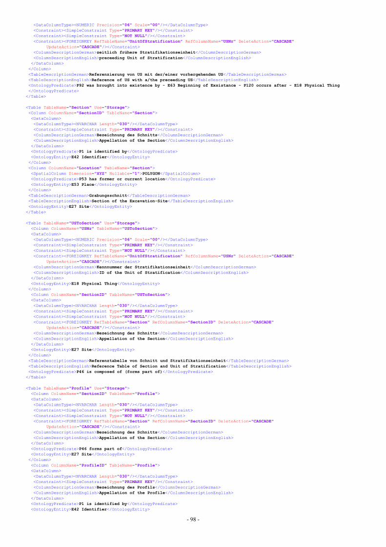
- 98 -
<DataColumnType><NUMERIC Precision="06" Scale="00"/></DataColumnType><Constraint><SimpleConstraint Type="PRIMARY KEY"/></Constraint><Constraint><SimpleConstraint Type="NOT NULL"/></Constraint><Constraint><FOREIGNKEY RefTableName="UnitOfStratification" RefColumnName="USNr" DeleteAction="CASCADE"
UpdateAction="CASCADE"/></Constraint><ColumnDescriptionGerman>zeitlich frühere Stratifikationseinheit</ColumnDescriptionGerman><ColumnDescriptionEnglish>preceeding Unit of Stratification</ColumnDescriptionEnglish>
</DataColumn></Column><TableDescriptionGerman>Referenzierung von US mit der/einer vorhergehenden US</TableDescriptionGerman><TableDescriptionEnglish>Reference of US with a/the preceeding US</TableDescriptionEnglish><OntologyPredicate>P92 was brought into existence by - E63 Beginning of Exsistance - P120 occurs after - E18 Physical Thing</OntologyPredicate>
</Table>
<Table TableName="Section" Use="Storage"><Column ColumnName="SectionID" TableName="Section"><DataColumn><DataColumnType><NVARCHAR Length="030"/></DataColumnType><Constraint><SimpleConstraint Type="PRIMARY KEY"/></Constraint><ColumnDescriptionGerman>Bezeichnung des Schnitts</ColumnDescriptionGerman><ColumnDescriptionEnglish>Appellation of the Section</ColumnDescriptionEnglish>
</DataColumn><OntologyPredicate>P1 is identified by</OntologyPredicate><OntologyEntity>E42 Identifier</OntologyEntity></Column><Column ColumnName="Location" TableName="Section"><SpatialColumn Dimension="XYZ" Nullable="1">POLYGON</SpatialColumn><OntologyPredicate>P53 has former or current location</OntologyPredicate><OntologyEntity>E53 Place</OntologyEntity></Column><TableDescriptionGerman>Grabungsschnitt</TableDescriptionGerman><TableDescriptionEnglish>Section of the Excavation-Site</TableDescriptionEnglish><OntologyEntity>E27 Site</OntologyEntity>
</Table>
<Table TableName="USToSection" Use="Storage"><Column ColumnName="USNr" TableName="USToSection"><DataColumn><DataColumnType><NUMERIC Precision="06" Scale="00"/></DataColumnType><Constraint><SimpleConstraint Type="PRIMARY KEY"/></Constraint><Constraint><SimpleConstraint Type="NOT NULL"/></Constraint><Constraint><FOREIGNKEY RefTableName="UnitOfStratification" RefColumnName="USNr" DeleteAction="CASCADE"
UpdateAction="CASCADE"/></Constraint><ColumnDescriptionGerman>Kennnummer der Stratifikationseinheit</ColumnDescriptionGerman><ColumnDescriptionEnglish>ID of the Unit of Stratification</ColumnDescriptionEnglish>
</DataColumn><OntologyEntity>E18 Physical Thing</OntologyEntity></Column><Column ColumnName="SectionID" TableName="USToSection"><DataColumn><DataColumnType><NVARCHAR Length="030"/></DataColumnType><Constraint><SimpleConstraint Type="PRIMARY KEY"/></Constraint><Constraint><SimpleConstraint Type="NOT NULL"/></Constraint><Constraint><FOREIGNKEY RefTableName="Section" RefColumnName="SectionID" DeleteAction="CASCADE"
UpdateAction="CASCADE"/></Constraint><ColumnDescriptionGerman>Bezeichnung des Schnitts</ColumnDescriptionGerman><ColumnDescriptionEnglish>Appellation of the Section</ColumnDescriptionEnglish>
</DataColumn><OntologyEntity>E27 Site</OntologyEntity></Column><TableDescriptionGerman>Referenztabelle von Schnitt und Stratifikationseinheit</TableDescriptionGerman><TableDescriptionEnglish>Reference Table of Section and Unit of Stratification</TableDescriptionEnglish><OntologyPredicate>P46 is composed of (forms part of)</OntologyPredicate>
</Table>
<Table TableName="Profile" Use="Storage"><Column ColumnName="SectionID" TableName="Profile"><DataColumn><DataColumnType><NVARCHAR Length="030"/></DataColumnType><Constraint><SimpleConstraint Type="PRIMARY KEY"/></Constraint><Constraint><SimpleConstraint Type="NOT NULL"/></Constraint><Constraint><FOREIGNKEY RefTableName="Section" RefColumnName="SectionID" DeleteAction="CASCADE"
UpdateAction="CASCADE"/></Constraint><ColumnDescriptionGerman>Bezeichnung des Schnitts</ColumnDescriptionGerman><ColumnDescriptionEnglish>Appellation of the Section</ColumnDescriptionEnglish>
</DataColumn><OntologyPredicate>P46 forms part of</OntologyPredicate><OntologyEntity>E27 Site</OntologyEntity></Column><Column ColumnName="ProfileID" TableName="Profile"><DataColumn><DataColumnType><NVARCHAR Length="030"/></DataColumnType><Constraint><SimpleConstraint Type="PRIMARY KEY"/></Constraint><ColumnDescriptionGerman>Bezeichnung des Profils</ColumnDescriptionGerman><ColumnDescriptionEnglish>Appellation of the Profile</ColumnDescriptionEnglish>
</DataColumn><OntologyPredicate>P1 is identified by</OntologyPredicate><OntologyEntity>E42 Identifier</OntologyEntity>
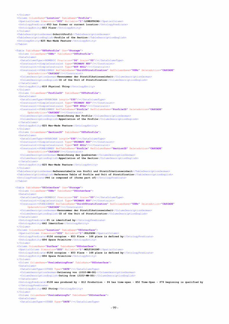
- 99 -
</Column><Column ColumnName="Location" TableName="Profile"><SpatialColumn Dimension="XYZ" Nullable="1">LINESTRING</SpatialColumn><OntologyPredicate>P53 has former or current location</OntologyPredicate><OntologyEntity>E53 Place</OntologyEntity></Column><TableDescriptionGerman>SchnittProfil</TableDescriptionGerman><TableDescriptionEnglish>Profile of the Section</TableDescriptionEnglish><OntologyEntity>E25 Man-Made Feature</OntologyEntity>
</Table>
<Table TableName="USToProfile" Use="Storage"><Column ColumnName="USNr" TableName="USToProfile"><DataColumn><DataColumnType><NUMERIC Precision="06" Scale="00"/></DataColumnType><Constraint><SimpleConstraint Type="PRIMARY KEY"/></Constraint><Constraint><SimpleConstraint Type="NOT NULL"/></Constraint><Constraint><FOREIGNKEY RefTableName="UnitOfStratification" RefColumnName="USNr" DeleteAction="CASCADE"
UpdateAction="CASCADE"/></Constraint><ColumnDescriptionGerman>Kennnummer der Stratifikationseinheit</ColumnDescriptionGerman><ColumnDescriptionEnglish>ID of the Unit of Stratification</ColumnDescriptionEnglish>
</DataColumn><OntologyEntity>E18 Physical Thing</OntologyEntity></Column><Column ColumnName="ProfileID" TableName="USToProfile"><DataColumn><DataColumnType><NVARCHAR Length="030"/></DataColumnType><Constraint><SimpleConstraint Type="PRIMARY KEY"/></Constraint><Constraint><SimpleConstraint Type="NOT NULL"/></Constraint><Constraint><FOREIGNKEY RefTableName="Profile" RefColumnName="ProfileID" DeleteAction="CASCADE"
UpdateAction="CASCADE"/></Constraint><ColumnDescriptionGerman>Bezeichnung des Profils</ColumnDescriptionGerman><ColumnDescriptionEnglish>Appellation of the Profile</ColumnDescriptionEnglish>
</DataColumn><OntologyEntity>E25 Man-Made Feature</OntologyEntity></Column><Column ColumnName="SectionID" TableName="USToProfile"><DataColumn><DataColumnType><NVARCHAR Length="030"/></DataColumnType><Constraint><SimpleConstraint Type="PRIMARY KEY"/></Constraint><Constraint><SimpleConstraint Type="NOT NULL"/></Constraint><Constraint><FOREIGNKEY RefTableName="Profile" RefColumnName="SectionID" DeleteAction="CASCADE"
UpdateAction="CASCADE"/></Constraint><ColumnDescriptionGerman>Bezeichnung des Quadranten</ColumnDescriptionGerman><ColumnDescriptionEnglish>Appellation of the Section</ColumnDescriptionEnglish>
</DataColumn><OntologyEntity>E25 Man-Made Feature</OntologyEntity></Column><TableDescriptionGerman>Referenztabelle von Profil und Stratifikationseinheit</TableDescriptionGerman><TableDescriptionEnglish>Reference Table of Profile and Unit of Stratification</TableDescriptionEnglish><OntologyPredicate>P46 is composed of (forms part of)</OntologyPredicate>
</Table>
<Table TableName="USInterface" Use="Storage"><Column ColumnName="USNr" TableName="USInterface"><DataColumn><DataColumnType><NUMERIC Precision="06" Scale="00"/></DataColumnType><Constraint><SimpleConstraint Type="PRIMARY KEY"/></Constraint><Constraint><FOREIGNKEY RefTableName="UnitOfStratification" RefColumnName="USNr" DeleteAction="CASCADE"
UpdateAction="CASCADE"/></Constraint><ColumnDescriptionGerman>Kennnummer der Stratifikationseinheit</ColumnDescriptionGerman><ColumnDescriptionEnglish>ID of the Unit of Stratification</ColumnDescriptionEnglish>
</DataColumn><OntologyPredicate>P1 is identified by</OntologyPredicate><OntologyEntity>E42 Identifier</OntologyEntity></Column><Column ColumnName="Location" TableName="USInterface"><SpatialColumn Dimension="XYZ" Nullable="1">POLYGON</SpatialColumn><OntologyPredicate>P156 occupies - E53 Place - 168 place is defined by</OntologyPredicate><OntologyEntity>E94 Space Primitive</OntologyEntity></Column><Column ColumnName="Surface" TableName="USInterface"><SpatialColumn Dimension="XYZ" Nullable="1">MULTIPOINT</SpatialColumn><OntologyPredicate>P156 occupies - E53 Place - 168 place is defined by</OntologyPredicate><OntologyEntity>E94 Space Primitive</OntologyEntity></Column><Column ColumnName="PrelimDatingFrom" TableName="USInterface"><DataColumn><DataColumnType><OTHER Type="DATE"/></DataColumnType><ColumnDescriptionGerman>Datierung von (JJJJ-MM-DD)</ColumnDescriptionGerman><ColumnDescriptionEnglish>Dating from (JJJJ-MM-DD)</ColumnDescriptionEnglish>
</DataColumn><OntologyPredicate>P108 was produced by - E12 Production - P4 has time-span - E52 Time-Span - P79 beginning is qualified by</OntologyPredicate><OntologyEntity>E62 String</OntologyEntity></Column><Column ColumnName="PrelimDatingTo" TableName="USInterface"><DataColumn><DataColumnType><OTHER Type="DATE"/></DataColumnType>
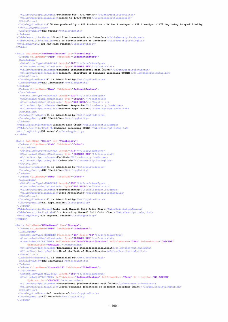
- 100 -
<ColumnDescriptionGerman>Datierung bis (JJJJ-MM-DD)</ColumnDescriptionGerman><ColumnDescriptionEnglish>Dating to (JJJJ-MM-DD)</ColumnDescriptionEnglish>
</DataColumn><OntologyPredicate>P108 was produced by - E12 Production - P4 has time-span - E52 Time-Span - P79 beginning is qualified by</OntologyPredicate><OntologyEntity>E62 String</OntologyEntity></Column><TableDescriptionGerman>Stratifikationseinheit als Interface</TableDescriptionGerman><TableDescriptionEnglish>Unit of Stratification as Interface</TableDescriptionEnglish><OntologyEntity>E25 Man-Made Feature</OntologyEntity>
</Table>
<Table TableName="SedimentTexture" Use="Vocabulary"><Column ColumnName="Term" TableName="SedimentTexture"><DataColumn><DataColumnType><NVARCHAR Length="003"/></DataColumnType><Constraint><SimpleConstraint Type="PRIMARY KEY"/></Constraint><ColumnDescriptionGerman>Sediment (Sedimentkürzel nach ÖNORM)</ColumnDescriptionGerman><ColumnDescriptionEnglish>Sediment (ShortForm of Sediment according ÖNORM)</ColumnDescriptionEnglish>
</DataColumn><OntologyPredicate>P1 is identified by</OntologyPredicate><OntologyEntity>E42 Identifier</OntologyEntity></Column><Column ColumnName="Name" TableName="SedimentTexture"><DataColumn><DataColumnType><NVARCHAR Length="020"/></DataColumnType><Constraint><SimpleConstraint Type="UNIQUE"/></Constraint><Constraint><SimpleConstraint Type="NOT NULL"/></Constraint><ColumnDescriptionGerman>Sediment Ansprache</ColumnDescriptionGerman><ColumnDescriptionEnglish>Sediment Appellation</ColumnDescriptionEnglish>
</DataColumn><OntologyPredicate>P1 is identified by</OntologyPredicate><OntologyEntity>E42 Identifier</OntologyEntity></Column><TableDescriptionGerman>Sediment nach ÖNORM</TableDescriptionGerman><TableDescriptionEnglish>Sediment according ÖNORM</TableDescriptionEnglish><OntologyEntity>E57 Material</OntologyEntity>
</Table>
<Table TableName="Color" Use="Vocabulary"><Column ColumnName="Code" TableName="Color"><DataColumn><DataColumnType><NVARCHAR Length="015"/></DataColumnType><Constraint><SimpleConstraint Type="PRIMARY KEY"/></Constraint><ColumnDescriptionGerman>FarbCode</ColumnDescriptionGerman><ColumnDescriptionEnglish>ColorCode</ColumnDescriptionEnglish>
</DataColumn><OntologyPredicate>P1 is identified by</OntologyPredicate><OntologyEntity>E42 Identifier</OntologyEntity></Column><Column ColumnName="Name" TableName="Color"><DataColumn><DataColumnType><NVARCHAR Length="035"/></DataColumnType><Constraint><SimpleConstraint Type="NOT NULL"/></Constraint><ColumnDescriptionGerman>Farbbezeichnung</ColumnDescriptionGerman><ColumnDescriptionEnglish>Color Appellation</ColumnDescriptionEnglish>
</DataColumn><OntologyPredicate>P1 is identified by</OntologyPredicate><OntologyEntity>E41 Appellation</OntologyEntity></Column><TableDescriptionGerman>Farbe nach Munsell Soil Color Chart</TableDescriptionGerman><TableDescriptionEnglish>Color According Munsell Soil Color Chart</TableDescriptionEnglish><OntologyEntity>E26 Physical Feature</OntologyEntity>
</Table>
<Table TableName="USSediment" Use="Storage"><Column ColumnName="USNr" TableName="USSediment"><DataColumn><DataColumnType><NUMERIC Precision="06" Scale="00"/></DataColumnType><Constraint><SimpleConstraint Type="PRIMARY KEY"/></Constraint><Constraint><FOREIGNKEY RefTableName="UnitOfStratification" RefColumnName="USNr" DeleteAction="CASCADE"
UpdateAction="CASCADE"/></Constraint><ColumnDescriptionGerman>Kennnummer der Stratifikationseinheit</ColumnDescriptionGerman><ColumnDescriptionEnglish>ID of the Unit of Stratification</ColumnDescriptionEnglish>
</DataColumn><OntologyPredicate>P1 is identified by</OntologyPredicate><OntologyEntity>E42 Identifier</OntologyEntity></Column><Column ColumnName="CoarseSoil" TableName="USSediment"><DataColumn><DataColumnType><NVARCHAR Length="003"/></DataColumnType><Constraint><FOREIGNKEY RefTableName="SedimentTexture" RefColumnName="Term" DeleteAction="NO ACTION"
UpdateAction="CASCADE"/></Constraint><ColumnDescriptionGerman>Grobsediment (Sedimentkürzel nach ÖNORM)</ColumnDescriptionGerman><ColumnDescriptionEnglish>Coarse-Sediment (ShortForm of Sediment according ÖNORM)</ColumnDescriptionEnglish>
</DataColumn><OntologyPredicate>P45 consists of</OntologyPredicate><OntologyEntity>E57 Material</OntologyEntity></Column>
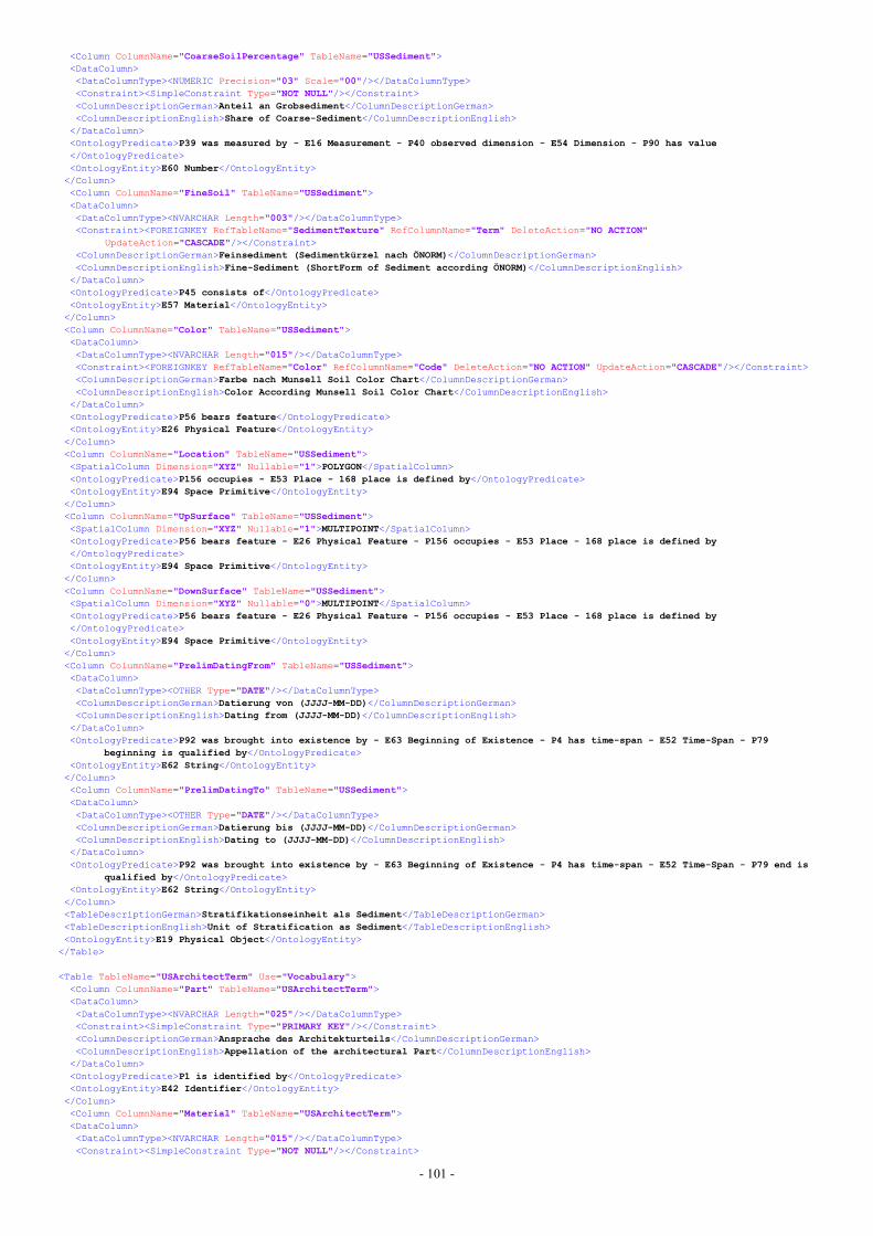
- 101 -
<Column ColumnName="CoarseSoilPercentage" TableName="USSediment"><DataColumn><DataColumnType><NUMERIC Precision="03" Scale="00"/></DataColumnType><Constraint><SimpleConstraint Type="NOT NULL"/></Constraint><ColumnDescriptionGerman>Anteil an Grobsediment</ColumnDescriptionGerman><ColumnDescriptionEnglish>Share of Coarse-Sediment</ColumnDescriptionEnglish>
</DataColumn><OntologyPredicate>P39 was measured by - E16 Measurement - P40 observed dimension - E54 Dimension - P90 has value</OntologyPredicate><OntologyEntity>E60 Number</OntologyEntity></Column><Column ColumnName="FineSoil" TableName="USSediment"><DataColumn><DataColumnType><NVARCHAR Length="003"/></DataColumnType><Constraint><FOREIGNKEY RefTableName="SedimentTexture" RefColumnName="Term" DeleteAction="NO ACTION"
UpdateAction="CASCADE"/></Constraint><ColumnDescriptionGerman>Feinsediment (Sedimentkürzel nach ÖNORM)</ColumnDescriptionGerman><ColumnDescriptionEnglish>Fine-Sediment (ShortForm of Sediment according ÖNORM)</ColumnDescriptionEnglish>
</DataColumn><OntologyPredicate>P45 consists of</OntologyPredicate><OntologyEntity>E57 Material</OntologyEntity></Column><Column ColumnName="Color" TableName="USSediment"><DataColumn><DataColumnType><NVARCHAR Length="015"/></DataColumnType><Constraint><FOREIGNKEY RefTableName="Color" RefColumnName="Code" DeleteAction="NO ACTION" UpdateAction="CASCADE"/></Constraint><ColumnDescriptionGerman>Farbe nach Munsell Soil Color Chart</ColumnDescriptionGerman><ColumnDescriptionEnglish>Color According Munsell Soil Color Chart</ColumnDescriptionEnglish>
</DataColumn><OntologyPredicate>P56 bears feature</OntologyPredicate><OntologyEntity>E26 Physical Feature</OntologyEntity></Column><Column ColumnName="Location" TableName="USSediment"><SpatialColumn Dimension="XYZ" Nullable="1">POLYGON</SpatialColumn><OntologyPredicate>P156 occupies - E53 Place - 168 place is defined by</OntologyPredicate><OntologyEntity>E94 Space Primitive</OntologyEntity></Column><Column ColumnName="UpSurface" TableName="USSediment"><SpatialColumn Dimension="XYZ" Nullable="1">MULTIPOINT</SpatialColumn><OntologyPredicate>P56 bears feature - E26 Physical Feature - P156 occupies - E53 Place - 168 place is defined by</OntologyPredicate><OntologyEntity>E94 Space Primitive</OntologyEntity></Column><Column ColumnName="DownSurface" TableName="USSediment"><SpatialColumn Dimension="XYZ" Nullable="0">MULTIPOINT</SpatialColumn><OntologyPredicate>P56 bears feature - E26 Physical Feature - P156 occupies - E53 Place - 168 place is defined by</OntologyPredicate><OntologyEntity>E94 Space Primitive</OntologyEntity></Column><Column ColumnName="PrelimDatingFrom" TableName="USSediment"><DataColumn><DataColumnType><OTHER Type="DATE"/></DataColumnType><ColumnDescriptionGerman>Datierung von (JJJJ-MM-DD)</ColumnDescriptionGerman><ColumnDescriptionEnglish>Dating from (JJJJ-MM-DD)</ColumnDescriptionEnglish>
</DataColumn><OntologyPredicate>P92 was brought into existence by - E63 Beginning of Existence - P4 has time-span - E52 Time-Span - P79
beginning is qualified by</OntologyPredicate><OntologyEntity>E62 String</OntologyEntity></Column><Column ColumnName="PrelimDatingTo" TableName="USSediment"><DataColumn><DataColumnType><OTHER Type="DATE"/></DataColumnType><ColumnDescriptionGerman>Datierung bis (JJJJ-MM-DD)</ColumnDescriptionGerman><ColumnDescriptionEnglish>Dating to (JJJJ-MM-DD)</ColumnDescriptionEnglish>
</DataColumn><OntologyPredicate>P92 was brought into existence by - E63 Beginning of Existence - P4 has time-span - E52 Time-Span - P79 end is
qualified by</OntologyPredicate><OntologyEntity>E62 String</OntologyEntity></Column><TableDescriptionGerman>Stratifikationseinheit als Sediment</TableDescriptionGerman><TableDescriptionEnglish>Unit of Stratification as Sediment</TableDescriptionEnglish><OntologyEntity>E19 Physical Object</OntologyEntity>
</Table>
<Table TableName="USArchitectTerm" Use="Vocabulary"><Column ColumnName="Part" TableName="USArchitectTerm"><DataColumn><DataColumnType><NVARCHAR Length="025"/></DataColumnType><Constraint><SimpleConstraint Type="PRIMARY KEY"/></Constraint><ColumnDescriptionGerman>Ansprache des Architekturteils</ColumnDescriptionGerman><ColumnDescriptionEnglish>Appellation of the architectural Part</ColumnDescriptionEnglish>
</DataColumn><OntologyPredicate>P1 is identified by</OntologyPredicate><OntologyEntity>E42 Identifier</OntologyEntity></Column><Column ColumnName="Material" TableName="USArchitectTerm"><DataColumn><DataColumnType><NVARCHAR Length="015"/></DataColumnType><Constraint><SimpleConstraint Type="NOT NULL"/></Constraint>
- 102 -
<ColumnDescriptionGerman>Holz oder Stein</ColumnDescriptionGerman><ColumnDescriptionEnglish>Wood or Stone</ColumnDescriptionEnglish>
</DataColumn><OntologyPredicate>P45 consists of</OntologyPredicate><OntologyEntity>E57 Material</OntologyEntity></Column><TableDescriptionGerman>Vocabular für Architekturteile</TableDescriptionGerman><TableDescriptionEnglish>Vocabulary of architectural Parts</TableDescriptionEnglish><OntologyEntity>E22 Man-Made Object</OntologyEntity>
</Table>
<Table TableName="USWoodPart" Use="Storage"><Column ColumnName="USNr" TableName="USWoodPart"><DataColumn><DataColumnType><NUMERIC Precision="06" Scale="00"/></DataColumnType><Constraint><SimpleConstraint Type="PRIMARY KEY"/></Constraint><Constraint><FOREIGNKEY RefTableName="USWood" RefColumnName="USNr" DeleteAction="CASCADE" UpdateAction="CASCADE"/></Constraint><ColumnDescriptionGerman>Stratifikationseinheit</ColumnDescriptionGerman><ColumnDescriptionEnglish>Unit of Stratification</ColumnDescriptionEnglish>
</DataColumn><OntologyPredicate>P46 forms part of</OntologyPredicate><OntologyEntity>E22 Man-Made Object</OntologyEntity></Column><Column ColumnName="Amount" TableName="USWoodPart"><DataColumn><DataColumnType><NUMERIC Precision="04" Scale="00"/></DataColumnType><Constraint><SimpleConstraint Type="NOT NULL"/></Constraint><ColumnDescriptionGerman>Anzahl der Teile</ColumnDescriptionGerman><ColumnDescriptionEnglish>Number of Parts</ColumnDescriptionEnglish>
</DataColumn><OntologyPredicate>P57 has number of parts</OntologyPredicate><OntologyEntity>E60 Number</OntologyEntity></Column><Column ColumnName="Part" TableName="USWoodPart"><DataColumn><DataColumnType><NVARCHAR Length="025"/></DataColumnType><Constraint><SimpleConstraint Type="NOT NULL"/></Constraint><Constraint><FOREIGNKEY RefTableName="USArchitectTerm" RefColumnName="Part" DeleteAction="NO ACTION"
UpdateAction="CASCADE"/></Constraint><ColumnDescriptionGerman>Ansprache des Architekturteils</ColumnDescriptionGerman><ColumnDescriptionEnglish>Appellation of the architectural Part</ColumnDescriptionEnglish>
</DataColumn><OntologyPredicate>P56 is composed of</OntologyPredicate><OntologyEntity>E22 Man-Made Object</OntologyEntity></Column><TableDescriptionGerman>Referenztabelle für Architekturteile und Holzarchitektur</TableDescriptionGerman><TableDescriptionEnglish>Reference Table for architectural Parts and wooden Architecture</TableDescriptionEnglish><OntologyEntity>E22 Man-Made Object</OntologyEntity>
</Table>
<Table TableName="USDimension" Use="Vocabulary"><Column ColumnName="Term" TableName="USDimension"><DataColumn><DataColumnType><NVARCHAR Length="010"/></DataColumnType><Constraint><SimpleConstraint Type="PRIMARY KEY"/></Constraint><ColumnDescriptionGerman>Vokabular</ColumnDescriptionGerman><ColumnDescriptionEnglish>Vocabulary</ColumnDescriptionEnglish>
</DataColumn><OntologyPredicate>P1 is identified by</OntologyPredicate><OntologyEntity>E41 Appellation</OntologyEntity></Column><TableDescriptionGerman>Signifikanz der Längen-, Breiten- und Höhenmessungen</TableDescriptionGerman><TableDescriptionEnglish>Significance of Measurements</TableDescriptionEnglish><OntologyEntity>E55 Type</OntologyEntity>
</Table>
<Table TableName="Orientation" Use="Vocabulary"><Column ColumnName="ShortTerm" TableName="Orientation"><DataColumn><DataColumnType><NCHAR Length="007"/></DataColumnType><Constraint><SimpleConstraint Type="PRIMARY KEY"/></Constraint><ColumnDescriptionGerman>Kürzel der Ausrichtung</ColumnDescriptionGerman><ColumnDescriptionEnglish>ShortTerm of the Direction</ColumnDescriptionEnglish>
</DataColumn><OntologyPredicate>P1 is identified by</OntologyPredicate><OntologyEntity>E42 Identifier</OntologyEntity></Column><Column ColumnName="LongTerm" TableName="Orientation"><DataColumn><DataColumnType><NVARCHAR Length="030"/></DataColumnType><Constraint><SimpleConstraint Type="NOT NULL"/></Constraint><Constraint><SimpleConstraint Type="UNIQUE"/></Constraint><ColumnDescriptionGerman>Ausrichtung</ColumnDescriptionGerman><ColumnDescriptionEnglish>Direction</ColumnDescriptionEnglish>
</DataColumn><OntologyPredicate>P1 is identified by</OntologyPredicate><OntologyEntity>E41 Appellation</OntologyEntity></Column><TableDescriptionGerman>Ausrichtung</TableDescriptionGerman>
- 103 -
<TableDescriptionEnglish>Direction</TableDescriptionEnglish><OntologyEntity>E3 Condition State</OntologyEntity>
</Table>
<Table TableName="USWNogging" Use="Vocabulary"><Column ColumnName="Material" TableName="USWNogging"><DataColumn><DataColumnType><NVARCHAR Length="020"/></DataColumnType><Constraint><SimpleConstraint Type="PRIMARY KEY"/></Constraint><ColumnDescriptionGerman>Material der Ausfachung</ColumnDescriptionGerman><ColumnDescriptionEnglish>Material of the Nogging</ColumnDescriptionEnglish>
</DataColumn><OntologyPredicate>P1 is identified by</OntologyPredicate><OntologyEntity>E41 Appellation</OntologyEntity></Column><TableDescriptionGerman>Ausfachung</TableDescriptionGerman><TableDescriptionEnglish>Nogging</TableDescriptionEnglish><OntologyEntity>E22 Man-Made Object</OntologyEntity>
</Table>
<Table TableName="USWType" Use="Vocabulary"><Column ColumnName="TermTaxonomy" TableName="USWType"><DataColumn><DataColumnType><NVARCHAR Length="030"/></DataColumnType><Constraint><SimpleConstraint Type="PRIMARY KEY"/></Constraint><ColumnDescriptionGerman>Taxonomie der Baumart</ColumnDescriptionGerman><ColumnDescriptionEnglish>Taxonomy of the Wood Type</ColumnDescriptionEnglish>
</DataColumn><OntologyPredicate>P1 is identified by</OntologyPredicate><OntologyEntity>E42 Identifier</OntologyEntity></Column><Column ColumnName="TermGerman" TableName="USWType"><DataColumn><DataColumnType><NVARCHAR Length="030"/></DataColumnType><Constraint><SimpleConstraint Type="UNIQUE"/></Constraint><Constraint><SimpleConstraint Type="NOT NULL"/></Constraint><ColumnDescriptionGerman>deutscher Begriff</ColumnDescriptionGerman><ColumnDescriptionEnglish>german Term</ColumnDescriptionEnglish>
</DataColumn><OntologyPredicate>P1 is identified by</OntologyPredicate><OntologyEntity>E41 Appellation</OntologyEntity></Column><TableDescriptionGerman>Baum- oder Holzart</TableDescriptionGerman><TableDescriptionEnglish>Wood Type</TableDescriptionEnglish><OntologyEntity>E57 Material</OntologyEntity>
</Table>
<Table TableName="USWood" Use="Storage"><Column ColumnName="USNr" TableName="USWood"><DataColumn><DataColumnType><NUMERIC Precision="06" Scale="00"/></DataColumnType><Constraint><SimpleConstraint Type="PRIMARY KEY"/></Constraint><Constraint><FOREIGNKEY RefTableName="UnitOfStratification" RefColumnName="USNr" DeleteAction="CASCADE"
UpdateAction="CASCADE"/></Constraint><ColumnDescriptionGerman>Kennnummer Stratifikationseinheit</ColumnDescriptionGerman><ColumnDescriptionEnglish>ID of the Unit of Stratification</ColumnDescriptionEnglish>
</DataColumn><OntologyPredicate>P1 is identified by</OntologyPredicate><OntologyEntity>E42 Identifier</OntologyEntity></Column><Column ColumnName="LengthCM" TableName="USWood"><DataColumn><DataColumnType><NUMERIC Precision="05" Scale="00"/></DataColumnType><Constraint><SimpleConstraint Type="NOT NULL"/></Constraint><ColumnDescriptionGerman>Länge der Stratifikationseinheit (Holzarchitektur) in Zentimeter</ColumnDescriptionGerman><ColumnDescriptionEnglish>Length of the of the Unit of Stratification (wooden Architecture) in Centimeter</ColumnDescriptionEnglish>
</DataColumn><OntologyPredicate>P39 was measured by - E16 Measurement - P40 observed dimension - E54 Dimension - P90 has value</OntologyPredicate><OntologyEntity>E60 Number</OntologyEntity></Column><Column ColumnName="LengthDimension" TableName="USWood"><DataColumn><DataColumnType><NVARCHAR Length="010"/></DataColumnType><Constraint><SimpleConstraint Type="NOT NULL"/></Constraint><Constraint><FOREIGNKEY RefTableName="USDimension" RefColumnName="Term" DeleteAction="RESTRICT"
UpdateAction="CASCADE"/></Constraint><ColumnDescriptionGerman>Signifikanz der Längenangabe</ColumnDescriptionGerman><ColumnDescriptionEnglish>Significance of the Length Measurement</ColumnDescriptionEnglish>
</DataColumn><OntologyPredicate>P39 was measured by - E16 Measurement - P3.1 has type</OntologyPredicate><OntologyEntity>E55 Type</OntologyEntity></Column><Column ColumnName="WidthCM" TableName="USWood"><DataColumn><DataColumnType><NUMERIC Precision="05" Scale="00"/></DataColumnType><Constraint><SimpleConstraint Type="NOT NULL"/></Constraint><ColumnDescriptionGerman>Breite der Stratifikationseinheit (Holzarchitektur) in Zentimeter</ColumnDescriptionGerman>
- 104 -
<ColumnDescriptionEnglish>Width of the of the Unit of Stratification (wooden Architecture) in Centimeter</ColumnDescriptionEnglish>
</DataColumn><OntologyPredicate>P39 was measured by - E16 Measurement - P40 observed dimension - E54 Dimension - P90 has value</OntologyPredicate><OntologyEntity>E60 Number</OntologyEntity></Column><Column ColumnName="WidthDimension" TableName="USWood"><DataColumn><DataColumnType><NVARCHAR Length="010"/></DataColumnType><Constraint><SimpleConstraint Type="NOT NULL"/></Constraint><Constraint><FOREIGNKEY RefTableName="USDimension" RefColumnName="Term" DeleteAction="RESTRICT"
UpdateAction="CASCADE"/></Constraint><ColumnDescriptionGerman>Signifikanz der Breitenangabe</ColumnDescriptionGerman><ColumnDescriptionEnglish>Significance of the Width Measurement</ColumnDescriptionEnglish>
</DataColumn><OntologyPredicate>P39 was measured by - E16 Measurement - P3.1 has type</OntologyPredicate><OntologyEntity>E55 Type</OntologyEntity></Column><Column ColumnName="HeigthCM" TableName="USWood"><DataColumn><DataColumnType><NUMERIC Precision="05" Scale="00"/></DataColumnType><Constraint><SimpleConstraint Type="NOT NULL"/></Constraint><ColumnDescriptionGerman>Höhe der Stratifikationseinheit (Holzarchitektur) in Zentimeter</ColumnDescriptionGerman><ColumnDescriptionEnglish>Height of the of the Unit of Stratification (wooden Architecture) in Centimeter</ColumnDescriptionEnglish>
</DataColumn><OntologyPredicate>P39 was measured by - E16 Measurement - P40 observed dimension - E54 Dimension - P90 has value</OntologyPredicate><OntologyEntity>E60 Number</OntologyEntity></Column><Column ColumnName="HeigthDimension" TableName="USWood"><DataColumn><DataColumnType><NVARCHAR Length="010"/></DataColumnType><Constraint><SimpleConstraint Type="NOT NULL"/></Constraint><Constraint><FOREIGNKEY RefTableName="USDimension" RefColumnName="Term" DeleteAction="RESTRICT"
UpdateAction="CASCADE"/></Constraint><ColumnDescriptionGerman>Signifikanz der Höhenangabe</ColumnDescriptionGerman><ColumnDescriptionEnglish>Significance of the Height Measurement</ColumnDescriptionEnglish>
</DataColumn><OntologyPredicate>P39 was measured by - E16 Measurement - P3.1 has type</OntologyPredicate><OntologyEntity>E55 Type</OntologyEntity></Column><Column ColumnName="Orientation" TableName="USWood"><DataColumn><DataColumnType><NCHAR Length="007"/></DataColumnType><Constraint><SimpleConstraint Type="NOT NULL"/></Constraint><Constraint><FOREIGNKEY RefTableName="Orientation" RefColumnName="ShortTerm" DeleteAction="RESTRICT"
UpdateAction="CASCADE"/></Constraint><ColumnDescriptionGerman>Kürzel der Ausrichtung</ColumnDescriptionGerman><ColumnDescriptionEnglish>ShortTerm of the Direction</ColumnDescriptionEnglish>
</DataColumn><OntologyPredicate>P44 has condition</OntologyPredicate><OntologyEntity>E3 Condition State</OntologyEntity></Column><Column ColumnName="Context" TableName="USWood"><DataColumn><DataColumnType><OTHER Type="TEXT"/></DataColumnType><ColumnDescriptionGerman>Kontext der Stratifikationseinheit</ColumnDescriptionGerman><ColumnDescriptionEnglish>Context of the Unit of Stratification</ColumnDescriptionEnglish>
</DataColumn><OntologyPredicate>P3 has note</OntologyPredicate><OntologyEntity>E62 String</OntologyEntity></Column><Column ColumnName="WoodType" TableName="USWood"><DataColumn><DataColumnType><NVARCHAR Length="030"/></DataColumnType><Constraint><SimpleConstraint Type="NOT NULL"/></Constraint><Constraint><FOREIGNKEY RefTableName="USWType" RefColumnName="TermTaxonomy" DeleteAction="RESTRICT"
UpdateAction="CASCADE"/></Constraint><ColumnDescriptionGerman>Holzart</ColumnDescriptionGerman><ColumnDescriptionEnglish>Type of Wood</ColumnDescriptionEnglish>
</DataColumn><OntologyPredicate>P45 consists of</OntologyPredicate><OntologyEntity>E57 Material</OntologyEntity></Column><Column ColumnName="Nogging" TableName="USWood"><DataColumn><DataColumnType><NVARCHAR Length="020"/></DataColumnType><Constraint><SimpleConstraint Type="NOT NULL"/></Constraint><Constraint><FOREIGNKEY RefTableName="USWNogging" RefColumnName="Material" DeleteAction="RESTRICT"
UpdateAction="CASCADE"/></Constraint><ColumnDescriptionGerman>Material der Ausfachung</ColumnDescriptionGerman><ColumnDescriptionEnglish>Material of Nogging</ColumnDescriptionEnglish>
</DataColumn><OntologyPredicate>P46 is composed of</OntologyPredicate><OntologyEntity>E22 Man-Made Object</OntologyEntity></Column><Column ColumnName="MaterialsOthers" TableName="USWood">
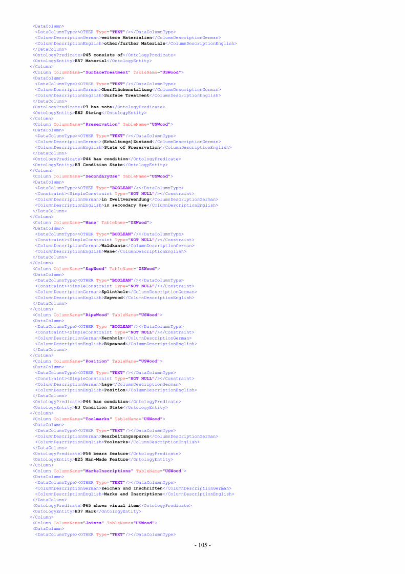
- 105 -
<DataColumn><DataColumnType><OTHER Type="TEXT"/></DataColumnType><ColumnDescriptionGerman>weitere Materialien</ColumnDescriptionGerman><ColumnDescriptionEnglish>other/further Materials</ColumnDescriptionEnglish>
</DataColumn><OntologyPredicate>P45 consists of</OntologyPredicate><OntologyEntity>E57 Material</OntologyEntity></Column><Column ColumnName="SurfaceTreatment" TableName="USWood"><DataColumn><DataColumnType><OTHER Type="TEXT"/></DataColumnType><ColumnDescriptionGerman>Oberflächenstaltung</ColumnDescriptionGerman><ColumnDescriptionEnglish>Surface Treatment</ColumnDescriptionEnglish>
</DataColumn><OntologyPredicate>P3 has note</OntologyPredicate><OntologyEntity>E62 String</OntologyEntity></Column><Column ColumnName="Preservation" TableName="USWood"><DataColumn><DataColumnType><OTHER Type="TEXT"/></DataColumnType><ColumnDescriptionGerman>(Erhaltungs)Zustand</ColumnDescriptionGerman><ColumnDescriptionEnglish>State of Preservation</ColumnDescriptionEnglish>
</DataColumn><OntologyPredicate>P44 has condition</OntologyPredicate><OntologyEntity>E3 Condition State</OntologyEntity></Column><Column ColumnName="SecondaryUse" TableName="USWood"><DataColumn><DataColumnType><OTHER Type="BOOLEAN"/></DataColumnType><Constraint><SimpleConstraint Type="NOT NULL"/></Constraint><ColumnDescriptionGerman>in Zweitverwendung</ColumnDescriptionGerman><ColumnDescriptionEnglish>in secondary Use</ColumnDescriptionEnglish>
</DataColumn></Column><Column ColumnName="Wane" TableName="USWood"><DataColumn><DataColumnType><OTHER Type="BOOLEAN"/></DataColumnType><Constraint><SimpleConstraint Type="NOT NULL"/></Constraint><ColumnDescriptionGerman>Waldkante</ColumnDescriptionGerman><ColumnDescriptionEnglish>Wane</ColumnDescriptionEnglish>
</DataColumn></Column><Column ColumnName="SapWood" TableName="USWood"><DataColumn><DataColumnType><OTHER Type="BOOLEAN"/></DataColumnType><Constraint><SimpleConstraint Type="NOT NULL"/></Constraint><ColumnDescriptionGerman>Splintholz</ColumnDescriptionGerman><ColumnDescriptionEnglish>Sapwood</ColumnDescriptionEnglish>
</DataColumn></Column><Column ColumnName="RipeWood" TableName="USWood"><DataColumn><DataColumnType><OTHER Type="BOOLEAN"/></DataColumnType><Constraint><SimpleConstraint Type="NOT NULL"/></Constraint><ColumnDescriptionGerman>Kernholz</ColumnDescriptionGerman><ColumnDescriptionEnglish>Ripewood</ColumnDescriptionEnglish>
</DataColumn></Column><Column ColumnName="Position" TableName="USWood"><DataColumn><DataColumnType><OTHER Type="TEXT"/></DataColumnType><Constraint><SimpleConstraint Type="NOT NULL"/></Constraint><ColumnDescriptionGerman>Lage</ColumnDescriptionGerman><ColumnDescriptionEnglish>Position</ColumnDescriptionEnglish>
</DataColumn><OntologyPredicate>P44 has condition</OntologyPredicate><OntologyEntity>E3 Condition State</OntologyEntity></Column><Column ColumnName="Toolmarks" TableName="USWood"><DataColumn><DataColumnType><OTHER Type="TEXT"/></DataColumnType><ColumnDescriptionGerman>Bearbeitungsspuren</ColumnDescriptionGerman><ColumnDescriptionEnglish>Toolmarks</ColumnDescriptionEnglish>
</DataColumn><OntologyPredicate>P56 bears feature</OntologyPredicate><OntologyEntity>E25 Man-Made Feature</OntologyEntity></Column><Column ColumnName="MarksInscriptions" TableName="USWood"><DataColumn><DataColumnType><OTHER Type="TEXT"/></DataColumnType><ColumnDescriptionGerman>Zeichen und Inschriften</ColumnDescriptionGerman><ColumnDescriptionEnglish>Marks and Inscriptions</ColumnDescriptionEnglish>
</DataColumn><OntologyPredicate>P65 shows visual item</OntologyPredicate><OntologyEntity>E37 Mark</OntologyEntity></Column><Column ColumnName="Joints" TableName="USWood"><DataColumn><DataColumnType><OTHER Type="TEXT"/></DataColumnType>
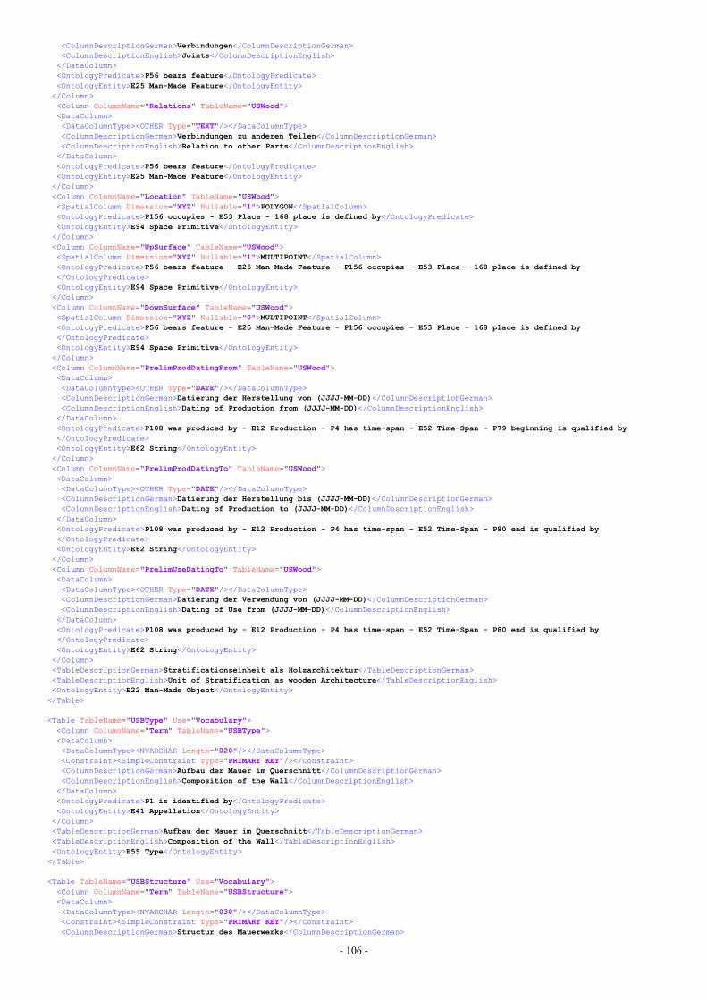
- 106 -
<ColumnDescriptionGerman>Verbindungen</ColumnDescriptionGerman><ColumnDescriptionEnglish>Joints</ColumnDescriptionEnglish>
</DataColumn><OntologyPredicate>P56 bears feature</OntologyPredicate><OntologyEntity>E25 Man-Made Feature</OntologyEntity></Column><Column ColumnName="Relations" TableName="USWood"><DataColumn><DataColumnType><OTHER Type="TEXT"/></DataColumnType><ColumnDescriptionGerman>Verbindungen zu anderen Teilen</ColumnDescriptionGerman><ColumnDescriptionEnglish>Relation to other Parts</ColumnDescriptionEnglish>
</DataColumn><OntologyPredicate>P56 bears feature</OntologyPredicate><OntologyEntity>E25 Man-Made Feature</OntologyEntity></Column><Column ColumnName="Location" TableName="USWood"><SpatialColumn Dimension="XYZ" Nullable="1">POLYGON</SpatialColumn><OntologyPredicate>P156 occupies - E53 Place - 168 place is defined by</OntologyPredicate><OntologyEntity>E94 Space Primitive</OntologyEntity></Column><Column ColumnName="UpSurface" TableName="USWood"><SpatialColumn Dimension="XYZ" Nullable="1">MULTIPOINT</SpatialColumn><OntologyPredicate>P56 bears feature - E25 Man-Made Feature - P156 occupies - E53 Place - 168 place is defined by</OntologyPredicate><OntologyEntity>E94 Space Primitive</OntologyEntity></Column><Column ColumnName="DownSurface" TableName="USWood"><SpatialColumn Dimension="XYZ" Nullable="0">MULTIPOINT</SpatialColumn><OntologyPredicate>P56 bears feature - E25 Man-Made Feature - P156 occupies - E53 Place - 168 place is defined by</OntologyPredicate><OntologyEntity>E94 Space Primitive</OntologyEntity></Column><Column ColumnName="PrelimProdDatingFrom" TableName="USWood"><DataColumn><DataColumnType><OTHER Type="DATE"/></DataColumnType><ColumnDescriptionGerman>Datierung der Herstellung von (JJJJ-MM-DD)</ColumnDescriptionGerman><ColumnDescriptionEnglish>Dating of Production from (JJJJ-MM-DD)</ColumnDescriptionEnglish>
</DataColumn><OntologyPredicate>P108 was produced by - E12 Production - P4 has time-span - E52 Time-Span - P79 beginning is qualified by</OntologyPredicate><OntologyEntity>E62 String</OntologyEntity></Column><Column ColumnName="PrelimProdDatingTo" TableName="USWood"><DataColumn><DataColumnType><OTHER Type="DATE"/></DataColumnType><ColumnDescriptionGerman>Datierung der Herstellung bis (JJJJ-MM-DD)</ColumnDescriptionGerman><ColumnDescriptionEnglish>Dating of Production to (JJJJ-MM-DD)</ColumnDescriptionEnglish>
</DataColumn><OntologyPredicate>P108 was produced by - E12 Production - P4 has time-span - E52 Time-Span - P80 end is qualified by</OntologyPredicate><OntologyEntity>E62 String</OntologyEntity></Column><Column ColumnName="PrelimUseDatingTo" TableName="USWood"><DataColumn><DataColumnType><OTHER Type="DATE"/></DataColumnType><ColumnDescriptionGerman>Datierung der Verwendung von (JJJJ-MM-DD)</ColumnDescriptionGerman><ColumnDescriptionEnglish>Dating of Use from (JJJJ-MM-DD)</ColumnDescriptionEnglish>
</DataColumn><OntologyPredicate>P108 was produced by - E12 Production - P4 has time-span - E52 Time-Span - P80 end is qualified by</OntologyPredicate><OntologyEntity>E62 String</OntologyEntity></Column><TableDescriptionGerman>Stratificationseinheit als Holzarchitektur</TableDescriptionGerman><TableDescriptionEnglish>Unit of Stratification as wooden Architecture</TableDescriptionEnglish><OntologyEntity>E22 Man-Made Object</OntologyEntity>
</Table>
<Table TableName="USBType" Use="Vocabulary"><Column ColumnName="Term" TableName="USBType"><DataColumn><DataColumnType><NVARCHAR Length="020"/></DataColumnType><Constraint><SimpleConstraint Type="PRIMARY KEY"/></Constraint><ColumnDescriptionGerman>Aufbau der Mauer im Querschnitt</ColumnDescriptionGerman><ColumnDescriptionEnglish>Composition of the Wall</ColumnDescriptionEnglish>
</DataColumn><OntologyPredicate>P1 is identified by</OntologyPredicate><OntologyEntity>E41 Appellation</OntologyEntity></Column><TableDescriptionGerman>Aufbau der Mauer im Querschnitt</TableDescriptionGerman><TableDescriptionEnglish>Composition of the Wall</TableDescriptionEnglish><OntologyEntity>E55 Type</OntologyEntity>
</Table>
<Table TableName="USBStructure" Use="Vocabulary"><Column ColumnName="Term" TableName="USBStructure"><DataColumn><DataColumnType><NVARCHAR Length="030"/></DataColumnType><Constraint><SimpleConstraint Type="PRIMARY KEY"/></Constraint><ColumnDescriptionGerman>Structur des Mauerwerks</ColumnDescriptionGerman>
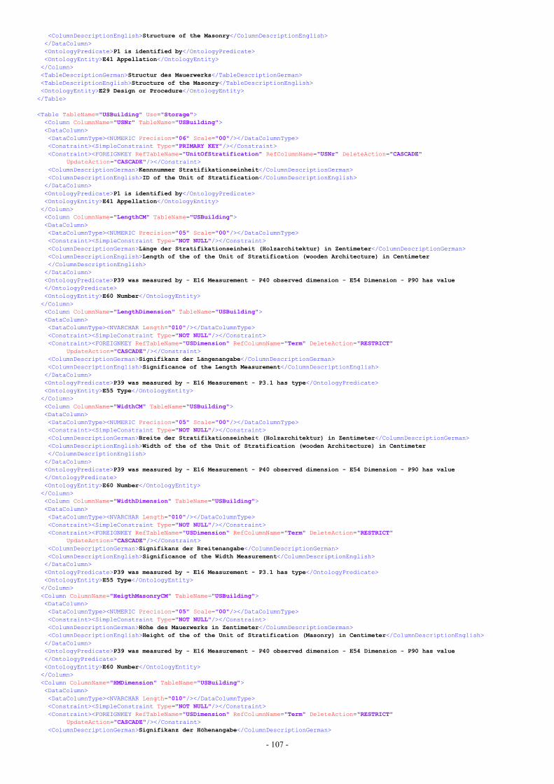
- 107 -
<ColumnDescriptionEnglish>Structure of the Masonry</ColumnDescriptionEnglish></DataColumn><OntologyPredicate>P1 is identified by</OntologyPredicate><OntologyEntity>E41 Appellation</OntologyEntity></Column><TableDescriptionGerman>Structur des Mauerwerks</TableDescriptionGerman><TableDescriptionEnglish>Structure of the Masonry</TableDescriptionEnglish><OntologyEntity>E29 Design or Procedure</OntologyEntity>
</Table>
<Table TableName="USBuilding" Use="Storage"><Column ColumnName="USNr" TableName="USBuilding"><DataColumn><DataColumnType><NUMERIC Precision="06" Scale="00"/></DataColumnType><Constraint><SimpleConstraint Type="PRIMARY KEY"/></Constraint><Constraint><FOREIGNKEY RefTableName="UnitOfStratification" RefColumnName="USNr" DeleteAction="CASCADE"
UpdateAction="CASCADE"/></Constraint><ColumnDescriptionGerman>Kennnummer Stratifikationseinheit</ColumnDescriptionGerman><ColumnDescriptionEnglish>ID of the Unit of Stratification</ColumnDescriptionEnglish>
</DataColumn><OntologyPredicate>P1 is identified by</OntologyPredicate><OntologyEntity>E41 Appellation</OntologyEntity></Column><Column ColumnName="LengthCM" TableName="USBuilding"><DataColumn><DataColumnType><NUMERIC Precision="05" Scale="00"/></DataColumnType><Constraint><SimpleConstraint Type="NOT NULL"/></Constraint><ColumnDescriptionGerman>Länge der Stratifikationseinheit (Holzarchitektur) in Zentimeter</ColumnDescriptionGerman><ColumnDescriptionEnglish>Length of the of the Unit of Stratification (wooden Architecture) in Centimeter</ColumnDescriptionEnglish>
</DataColumn><OntologyPredicate>P39 was measured by - E16 Measurement - P40 observed dimension - E54 Dimension - P90 has value</OntologyPredicate><OntologyEntity>E60 Number</OntologyEntity></Column><Column ColumnName="LengthDimension" TableName="USBuilding"><DataColumn><DataColumnType><NVARCHAR Length="010"/></DataColumnType><Constraint><SimpleConstraint Type="NOT NULL"/></Constraint><Constraint><FOREIGNKEY RefTableName="USDimension" RefColumnName="Term" DeleteAction="RESTRICT"
UpdateAction="CASCADE"/></Constraint><ColumnDescriptionGerman>Signifikanz der Längenangabe</ColumnDescriptionGerman><ColumnDescriptionEnglish>Significance of the Length Measurement</ColumnDescriptionEnglish>
</DataColumn><OntologyPredicate>P39 was measured by - E16 Measurement - P3.1 has type</OntologyPredicate><OntologyEntity>E55 Type</OntologyEntity></Column><Column ColumnName="WidthCM" TableName="USBuilding"><DataColumn><DataColumnType><NUMERIC Precision="05" Scale="00"/></DataColumnType><Constraint><SimpleConstraint Type="NOT NULL"/></Constraint><ColumnDescriptionGerman>Breite der Stratifikationseinheit (Holzarchitektur) in Zentimeter</ColumnDescriptionGerman><ColumnDescriptionEnglish>Width of the of the Unit of Stratification (wooden Architecture) in Centimeter</ColumnDescriptionEnglish>
</DataColumn><OntologyPredicate>P39 was measured by - E16 Measurement - P40 observed dimension - E54 Dimension - P90 has value</OntologyPredicate><OntologyEntity>E60 Number</OntologyEntity></Column><Column ColumnName="WidthDimension" TableName="USBuilding"><DataColumn><DataColumnType><NVARCHAR Length="010"/></DataColumnType><Constraint><SimpleConstraint Type="NOT NULL"/></Constraint><Constraint><FOREIGNKEY RefTableName="USDimension" RefColumnName="Term" DeleteAction="RESTRICT"
UpdateAction="CASCADE"/></Constraint><ColumnDescriptionGerman>Signifikanz der Breitenangabe</ColumnDescriptionGerman><ColumnDescriptionEnglish>Significance of the Width Measurement</ColumnDescriptionEnglish>
</DataColumn><OntologyPredicate>P39 was measured by - E16 Measurement - P3.1 has type</OntologyPredicate><OntologyEntity>E55 Type</OntologyEntity></Column><Column ColumnName="HeigthMasonryCM" TableName="USBuilding"><DataColumn><DataColumnType><NUMERIC Precision="05" Scale="00"/></DataColumnType><Constraint><SimpleConstraint Type="NOT NULL"/></Constraint><ColumnDescriptionGerman>Höhe des Mauerwerks in Zentimeter</ColumnDescriptionGerman><ColumnDescriptionEnglish>Height of the of the Unit of Stratification (Masonry) in Centimeter</ColumnDescriptionEnglish>
</DataColumn><OntologyPredicate>P39 was measured by - E16 Measurement - P40 observed dimension - E54 Dimension - P90 has value</OntologyPredicate><OntologyEntity>E60 Number</OntologyEntity></Column><Column ColumnName="HMDimension" TableName="USBuilding"><DataColumn><DataColumnType><NVARCHAR Length="010"/></DataColumnType><Constraint><SimpleConstraint Type="NOT NULL"/></Constraint><Constraint><FOREIGNKEY RefTableName="USDimension" RefColumnName="Term" DeleteAction="RESTRICT"
UpdateAction="CASCADE"/></Constraint><ColumnDescriptionGerman>Signifikanz der Höhenangabe</ColumnDescriptionGerman>

- 108 -
<ColumnDescriptionEnglish>Significance of the Height Measurement</ColumnDescriptionEnglish></DataColumn><OntologyPredicate>P39 was measured by - E16 Measurement - P3.1 has type</OntologyPredicate><OntologyEntity>E55 Type</OntologyEntity></Column><Column ColumnName="HeigthFoundingCM" TableName="USBuilding"><DataColumn><DataColumnType><NUMERIC Precision="05" Scale="00"/></DataColumnType><Constraint><SimpleConstraint Type="NOT NULL"/></Constraint><ColumnDescriptionGerman>Höhe des Fundaments in Zentimeter</ColumnDescriptionGerman><ColumnDescriptionEnglish>Height of the of the Founding in Centimeter</ColumnDescriptionEnglish>
</DataColumn><OntologyPredicate>P39 was measured by - E16 Measurement - P40 observed dimension - E54 Dimension - P90 has value</OntologyPredicate><OntologyEntity>E60 Number</OntologyEntity></Column><Column ColumnName="HFDimension" TableName="USBuilding"><DataColumn><DataColumnType><NVARCHAR Length="010"/></DataColumnType><Constraint><SimpleConstraint Type="NOT NULL"/></Constraint><Constraint><FOREIGNKEY RefTableName="USDimension" RefColumnName="Term" DeleteAction="RESTRICT"
UpdateAction="CASCADE"/></Constraint><ColumnDescriptionGerman>Signifikanz der Höhenangabe des Fundaments</ColumnDescriptionGerman><ColumnDescriptionEnglish>Significance of the Height Measurement of the Founding</ColumnDescriptionEnglish>
</DataColumn><OntologyPredicate>P39 was measured by - E16 Measurement - P3.1 has type</OntologyPredicate><OntologyEntity>E55 Type</OntologyEntity></Column><Column ColumnName="Orientation" TableName="USBuilding"><DataColumn><DataColumnType><NCHAR Length="007"/></DataColumnType><Constraint><SimpleConstraint Type="NOT NULL"/></Constraint><Constraint><FOREIGNKEY RefTableName="Orientation" RefColumnName="ShortTerm" DeleteAction="RESTRICT"
UpdateAction="CASCADE"/></Constraint><ColumnDescriptionGerman>Kürzel der Ausrichtung</ColumnDescriptionGerman><ColumnDescriptionEnglish>ShortTerm of the Direction</ColumnDescriptionEnglish>
</DataColumn><OntologyPredicate>P44 has condition</OntologyPredicate><OntologyEntity>E3 Condition State</OntologyEntity></Column><Column ColumnName="Type" TableName="USBuilding"><DataColumn><DataColumnType><NVARCHAR Length="020"/></DataColumnType><Constraint><SimpleConstraint Type="NOT NULL"/></Constraint><Constraint><FOREIGNKEY RefTableName="USBType" RefColumnName="Term" DeleteAction="RESTRICT" UpdateAction="CASCADE"/></Constraint><ColumnDescriptionGerman>Aufbau</ColumnDescriptionGerman><ColumnDescriptionEnglish>Construction Type</ColumnDescriptionEnglish>
</DataColumn><OntologyPredicate>P108 was produced by - E12 Production - P32 used general technique</OntologyPredicate><OntologyEntity>E55 Type</OntologyEntity></Column><Column ColumnName="Structure" TableName="USBuilding"><DataColumn><DataColumnType><NVARCHAR Length="030"/></DataColumnType><Constraint><SimpleConstraint Type="NOT NULL"/></Constraint><Constraint><FOREIGNKEY RefTableName="USBStructure" RefColumnName="Term" DeleteAction="RESTRICT"
UpdateAction="CASCADE"/></Constraint><ColumnDescriptionGerman>Structur des Mauerwerks</ColumnDescriptionGerman><ColumnDescriptionEnglish>Structure of the Masonry</ColumnDescriptionEnglish>
</DataColumn><OntologyPredicate>P108 was produced by - E12 Production - P33 used specific technique</OntologyPredicate><OntologyEntity>E29 Design or Procedure</OntologyEntity></Column><Column ColumnName="Description" TableName="USBuilding"><DataColumn><DataColumnType><OTHER Type="TEXT"/></DataColumnType><ColumnDescriptionGerman>Beschreibung</ColumnDescriptionGerman><ColumnDescriptionEnglish>Description</ColumnDescriptionEnglish>
</DataColumn><OntologyPredicate>P3 has note</OntologyPredicate><OntologyEntity>E62 String</OntologyEntity></Column><Column ColumnName="ButlogHole" TableName="USBuilding"><DataColumn><DataColumnType><OTHER Type="BOOLEAN"/></DataColumnType><Constraint><SimpleConstraint Type="NOT NULL"/></Constraint><ColumnDescriptionGerman>Gerüstloch</ColumnDescriptionGerman><ColumnDescriptionEnglish>Butlog Hole</ColumnDescriptionEnglish>
</DataColumn></Column><Column ColumnName="BeamHole" TableName="USBuilding"><DataColumn><DataColumnType><OTHER Type="BOOLEAN"/></DataColumnType><Constraint><SimpleConstraint Type="NOT NULL"/></Constraint><ColumnDescriptionGerman>Balkenloch</ColumnDescriptionGerman><ColumnDescriptionEnglish>Beam Hole</ColumnDescriptionEnglish>
</DataColumn></Column><Column ColumnName="HoleLocation" TableName="USBuilding">
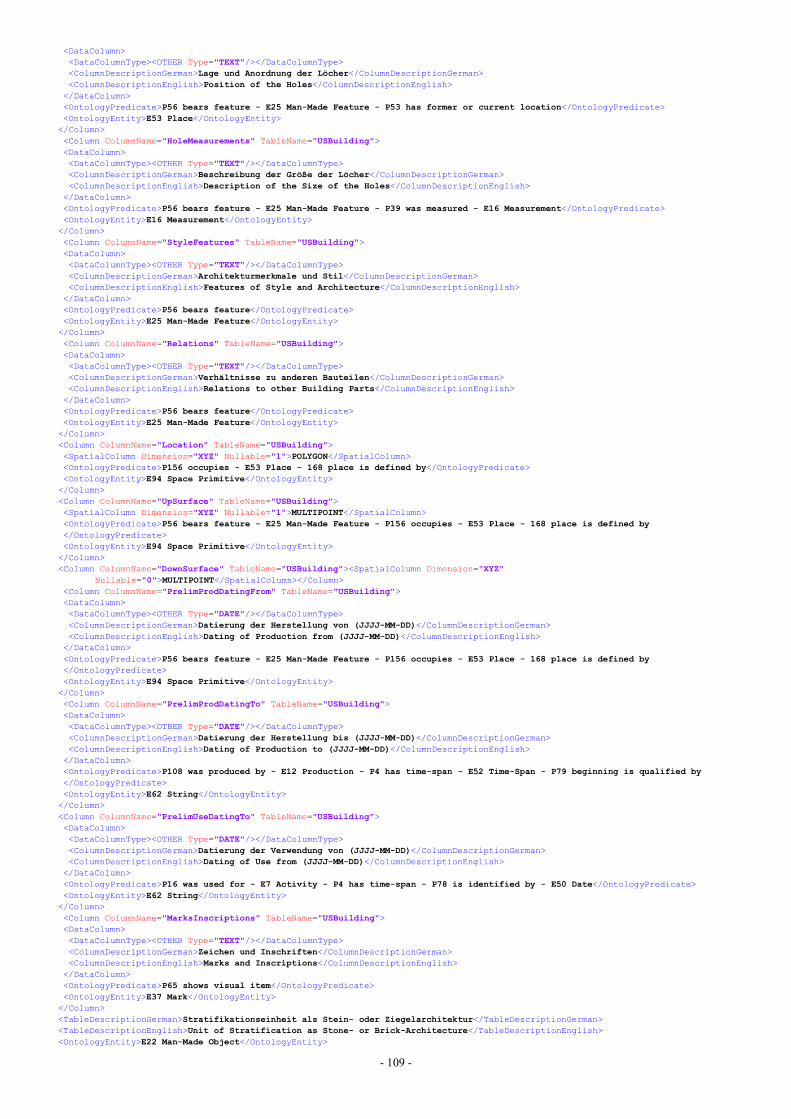
- 109 -
<DataColumn><DataColumnType><OTHER Type="TEXT"/></DataColumnType><ColumnDescriptionGerman>Lage und Anordnung der Löcher</ColumnDescriptionGerman><ColumnDescriptionEnglish>Position of the Holes</ColumnDescriptionEnglish>
</DataColumn><OntologyPredicate>P56 bears feature - E25 Man-Made Feature - P53 has former or current location</OntologyPredicate><OntologyEntity>E53 Place</OntologyEntity></Column><Column ColumnName="HoleMeasurements" TableName="USBuilding"><DataColumn><DataColumnType><OTHER Type="TEXT"/></DataColumnType><ColumnDescriptionGerman>Beschreibung der Größe der Löcher</ColumnDescriptionGerman><ColumnDescriptionEnglish>Description of the Size of the Holes</ColumnDescriptionEnglish>
</DataColumn><OntologyPredicate>P56 bears feature - E25 Man-Made Feature - P39 was measured - E16 Measurement</OntologyPredicate><OntologyEntity>E16 Measurement</OntologyEntity></Column><Column ColumnName="StyleFeatures" TableName="USBuilding"><DataColumn><DataColumnType><OTHER Type="TEXT"/></DataColumnType><ColumnDescriptionGerman>Architekturmerkmale und Stil</ColumnDescriptionGerman><ColumnDescriptionEnglish>Features of Style and Architecture</ColumnDescriptionEnglish>
</DataColumn><OntologyPredicate>P56 bears feature</OntologyPredicate><OntologyEntity>E25 Man-Made Feature</OntologyEntity></Column><Column ColumnName="Relations" TableName="USBuilding"><DataColumn><DataColumnType><OTHER Type="TEXT"/></DataColumnType><ColumnDescriptionGerman>Verhältnisse zu anderen Bauteilen</ColumnDescriptionGerman><ColumnDescriptionEnglish>Relations to other Building Parts</ColumnDescriptionEnglish>
</DataColumn><OntologyPredicate>P56 bears feature</OntologyPredicate><OntologyEntity>E25 Man-Made Feature</OntologyEntity></Column><Column ColumnName="Location" TableName="USBuilding"><SpatialColumn Dimension="XYZ" Nullable="1">POLYGON</SpatialColumn><OntologyPredicate>P156 occupies - E53 Place - 168 place is defined by</OntologyPredicate><OntologyEntity>E94 Space Primitive</OntologyEntity></Column><Column ColumnName="UpSurface" TableName="USBuilding"><SpatialColumn Dimension="XYZ" Nullable="1">MULTIPOINT</SpatialColumn><OntologyPredicate>P56 bears feature - E25 Man-Made Feature - P156 occupies - E53 Place - 168 place is defined by</OntologyPredicate><OntologyEntity>E94 Space Primitive</OntologyEntity></Column><Column ColumnName="DownSurface" TableName="USBuilding"><SpatialColumn Dimension="XYZ"
Nullable="0">MULTIPOINT</SpatialColumn></Column><Column ColumnName="PrelimProdDatingFrom" TableName="USBuilding"><DataColumn><DataColumnType><OTHER Type="DATE"/></DataColumnType><ColumnDescriptionGerman>Datierung der Herstellung von (JJJJ-MM-DD)</ColumnDescriptionGerman><ColumnDescriptionEnglish>Dating of Production from (JJJJ-MM-DD)</ColumnDescriptionEnglish>
</DataColumn><OntologyPredicate>P56 bears feature - E25 Man-Made Feature - P156 occupies - E53 Place - 168 place is defined by</OntologyPredicate><OntologyEntity>E94 Space Primitive</OntologyEntity></Column><Column ColumnName="PrelimProdDatingTo" TableName="USBuilding"><DataColumn><DataColumnType><OTHER Type="DATE"/></DataColumnType><ColumnDescriptionGerman>Datierung der Herstellung bis (JJJJ-MM-DD)</ColumnDescriptionGerman><ColumnDescriptionEnglish>Dating of Production to (JJJJ-MM-DD)</ColumnDescriptionEnglish>
</DataColumn><OntologyPredicate>P108 was produced by - E12 Production - P4 has time-span - E52 Time-Span - P79 beginning is qualified by</OntologyPredicate><OntologyEntity>E62 String</OntologyEntity></Column><Column ColumnName="PrelimUseDatingTo" TableName="USBuilding"><DataColumn><DataColumnType><OTHER Type="DATE"/></DataColumnType><ColumnDescriptionGerman>Datierung der Verwendung von (JJJJ-MM-DD)</ColumnDescriptionGerman><ColumnDescriptionEnglish>Dating of Use from (JJJJ-MM-DD)</ColumnDescriptionEnglish>
</DataColumn><OntologyPredicate>P16 was used for - E7 Activity - P4 has time-span - P78 is identified by - E50 Date</OntologyPredicate><OntologyEntity>E62 String</OntologyEntity></Column><Column ColumnName="MarksInscriptions" TableName="USBuilding"><DataColumn><DataColumnType><OTHER Type="TEXT"/></DataColumnType><ColumnDescriptionGerman>Zeichen und Inschriften</ColumnDescriptionGerman><ColumnDescriptionEnglish>Marks and Inscriptions</ColumnDescriptionEnglish>
</DataColumn><OntologyPredicate>P65 shows visual item</OntologyPredicate><OntologyEntity>E37 Mark</OntologyEntity></Column><TableDescriptionGerman>Stratifikationseinheit als Stein- oder Ziegelarchitektur</TableDescriptionGerman><TableDescriptionEnglish>Unit of Stratification as Stone- or Brick-Architecture</TableDescriptionEnglish><OntologyEntity>E22 Man-Made Object</OntologyEntity>
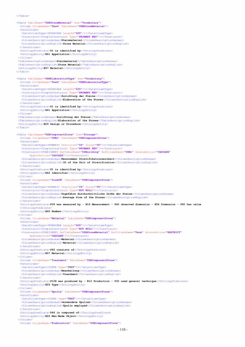
- 110 -
</Table>
<Table TableName="USBStoneMaterial" Use="Vocabulary"><Column ColumnName="Term" TableName="USBStoneMaterial"><DataColumn><DataColumnType><NVARCHAR Length="020"/></DataColumnType><Constraint><SimpleConstraint Type="PRIMARY KEY"/></Constraint><ColumnDescriptionGerman>Steinmaterial</ColumnDescriptionGerman><ColumnDescriptionEnglish>Stone Material</ColumnDescriptionEnglish>
</DataColumn><OntologyPredicate>P1 is identified by</OntologyPredicate><OntologyEntity>E41 Appellation</OntologyEntity></Column><TableDescriptionGerman>Steinmaterial</TableDescriptionGerman><TableDescriptionEnglish>Stone Material</TableDescriptionEnglish><OntologyEntity>E57 Material</OntologyEntity>
</Table>
<Table TableName="USBElaborationType" Use="Vocabulary"><Column ColumnName="Term" TableName="USBElaborationType"><DataColumn><DataColumnType><NVARCHAR Length="020"/></DataColumnType><Constraint><SimpleConstraint Type="PRIMARY KEY"/></Constraint><ColumnDescriptionGerman>Zurichtung der Steine</ColumnDescriptionGerman><ColumnDescriptionEnglish>Elaboration of the Stones</ColumnDescriptionEnglish>
</DataColumn><OntologyPredicate>P1 is identified by</OntologyPredicate><OntologyEntity>E41 Appellation</OntologyEntity></Column><TableDescriptionGerman>Zurichtung der Steine</TableDescriptionGerman><TableDescriptionEnglish>Elaboration of the Stones</TableDescriptionEnglish><OntologyEntity>E29 Design or Procedure</OntologyEntity>
</Table>
<Table TableName="USBComponentStone" Use="Storage"><Column ColumnName="USNr" TableName="USBComponentStone"><DataColumn><DataColumnType><NUMERIC Precision="06" Scale="00"/></DataColumnType><Constraint><SimpleConstraint Type="PRIMARY KEY"/></Constraint><Constraint><FOREIGNKEY RefTableName="USBuilding" RefColumnName="USNr" DeleteAction="CASCADE"
UpdateAction="CASCADE"/></Constraint><ColumnDescriptionGerman>Kennnummer Stratifikationseinheit</ColumnDescriptionGerman><ColumnDescriptionEnglish>ID of the Unit of Stratification</ColumnDescriptionEnglish>
</DataColumn><OntologyPredicate>P1 is identified by</OntologyPredicate><OntologyEntity>E42 Identifier</OntologyEntity></Column><Column ColumnName="SizeCM" TableName="USBComponentStone"><DataColumn><DataColumnType><NUMERIC Precision="04" Scale="00"/></DataColumnType><Constraint><SimpleConstraint Type="NOT NULL"/></Constraint><ColumnDescriptionGerman>Ungefähre durchschnittliche Größe der Steine</ColumnDescriptionGerman><ColumnDescriptionEnglish>Average Size of the Stones</ColumnDescriptionEnglish>
</DataColumn><OntologyPredicate>P39 was measured by - E16 Measurement - P40 observed dimension - E54 Dimension - P90 has value</OntologyPredicate><OntologyEntity>E60 Number</OntologyEntity></Column><Column ColumnName="Material" TableName="USBComponentStone"><DataColumn><DataColumnType><NVARCHAR Length="020"/></DataColumnType><Constraint><SimpleConstraint Type="NOT NULL"/></Constraint><Constraint><FOREIGNKEY RefTableName="USBStoneMaterial" RefColumnName="Term" DeleteAction="RESTRICT"
UpdateAction="CASCADE"/></Constraint><ColumnDescriptionGerman>Material</ColumnDescriptionGerman><ColumnDescriptionEnglish>Material</ColumnDescriptionEnglish>
</DataColumn><OntologyPredicate>P45 consists of</OntologyPredicate><OntologyEntity>E57 Material</OntologyEntity></Column><Column ColumnName="Treatment" TableName="USBComponentStone"><DataColumn><DataColumnType><OTHER Type="TEXT"/></DataColumnType><ColumnDescriptionGerman>Bearbeitung</ColumnDescriptionGerman><ColumnDescriptionEnglish>Treatment</ColumnDescriptionEnglish>
</DataColumn><OntologyPredicate>P108 was produced by - E12 Production - P32 used general technique</OntologyPredicate><OntologyEntity>E55 Type</OntologyEntity></Column><Column ColumnName="Spoils" TableName="USBComponentStone"><DataColumn><DataColumnType><OTHER Type="TEXT"/></DataColumnType><ColumnDescriptionGerman>verwendete Spolien</ColumnDescriptionGerman><ColumnDescriptionEnglish>Spoils employed</ColumnDescriptionEnglish>
</DataColumn><OntologyPredicate>P46 is composed of</OntologyPredicate><OntologyEntity>E22 Man-Made Object</OntologyEntity></Column><Column ColumnName="Elaboration" TableName="USBComponentStone">
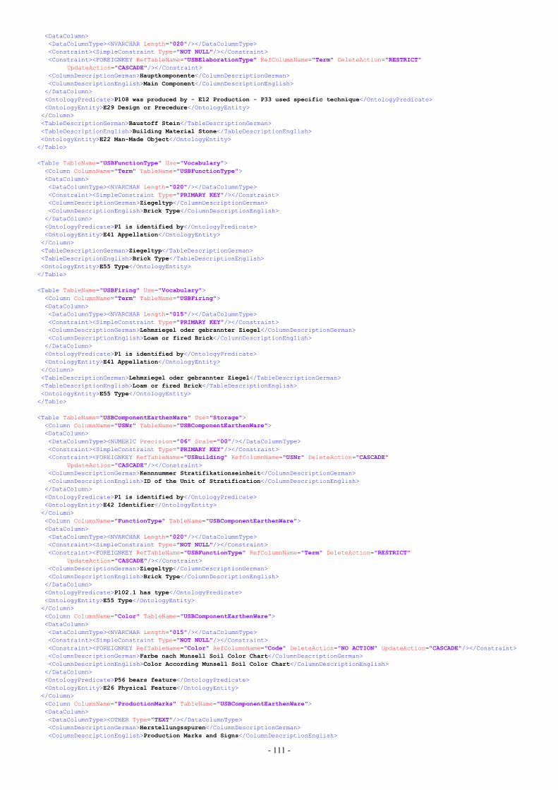
- 111 -
<DataColumn><DataColumnType><NVARCHAR Length="020"/></DataColumnType><Constraint><SimpleConstraint Type="NOT NULL"/></Constraint><Constraint><FOREIGNKEY RefTableName="USBElaborationType" RefColumnName="Term" DeleteAction="RESTRICT"
UpdateAction="CASCADE"/></Constraint><ColumnDescriptionGerman>Hauptkomponente</ColumnDescriptionGerman><ColumnDescriptionEnglish>Main Component</ColumnDescriptionEnglish>
</DataColumn><OntologyPredicate>P108 was produced by - E12 Production - P33 used specific technique</OntologyPredicate><OntologyEntity>E29 Design or Precedure</OntologyEntity></Column><TableDescriptionGerman>Baustoff Stein</TableDescriptionGerman><TableDescriptionEnglish>Building Material Stone</TableDescriptionEnglish><OntologyEntity>E22 Man-Made Object</OntologyEntity>
</Table>
<Table TableName="USBFunctionType" Use="Vocabulary"><Column ColumnName="Term" TableName="USBFunctionType"><DataColumn><DataColumnType><NVARCHAR Length="020"/></DataColumnType><Constraint><SimpleConstraint Type="PRIMARY KEY"/></Constraint><ColumnDescriptionGerman>Ziegeltyp</ColumnDescriptionGerman><ColumnDescriptionEnglish>Brick Type</ColumnDescriptionEnglish>
</DataColumn><OntologyPredicate>P1 is identified by</OntologyPredicate><OntologyEntity>E41 Appellation</OntologyEntity></Column><TableDescriptionGerman>Ziegeltyp</TableDescriptionGerman><TableDescriptionEnglish>Brick Type</TableDescriptionEnglish><OntologyEntity>E55 Type</OntologyEntity>
</Table>
<Table TableName="USBFiring" Use="Vocabulary"><Column ColumnName="Term" TableName="USBFiring"><DataColumn><DataColumnType><NVARCHAR Length="015"/></DataColumnType><Constraint><SimpleConstraint Type="PRIMARY KEY"/></Constraint><ColumnDescriptionGerman>Lehmziegel oder gebrannter Ziegel</ColumnDescriptionGerman><ColumnDescriptionEnglish>Loam or fired Brick</ColumnDescriptionEnglish>
</DataColumn><OntologyPredicate>P1 is identified by</OntologyPredicate><OntologyEntity>E41 Appellation</OntologyEntity></Column><TableDescriptionGerman>Lehmziegel oder gebrannter Ziegel</TableDescriptionGerman><TableDescriptionEnglish>Loam or fired Brick</TableDescriptionEnglish><OntologyEntity>E55 Type</OntologyEntity>
</Table>
<Table TableName="USBComponentEarthenWare" Use="Storage"><Column ColumnName="USNr" TableName="USBComponentEarthenWare"><DataColumn><DataColumnType><NUMERIC Precision="06" Scale="00"/></DataColumnType><Constraint><SimpleConstraint Type="PRIMARY KEY"/></Constraint><Constraint><FOREIGNKEY RefTableName="USBuilding" RefColumnName="USNr" DeleteAction="CASCADE"
UpdateAction="CASCADE"/></Constraint><ColumnDescriptionGerman>Kennnummer Stratifikationseinheit</ColumnDescriptionGerman><ColumnDescriptionEnglish>ID of the Unit of Stratification</ColumnDescriptionEnglish>
</DataColumn><OntologyPredicate>P1 is identified by</OntologyPredicate><OntologyEntity>E42 Identifier</OntologyEntity></Column><Column ColumnName="FunctionType" TableName="USBComponentEarthenWare"><DataColumn><DataColumnType><NVARCHAR Length="020"/></DataColumnType><Constraint><SimpleConstraint Type="NOT NULL"/></Constraint><Constraint><FOREIGNKEY RefTableName="USBFunctionType" RefColumnName="Term" DeleteAction="RESTRICT"
UpdateAction="CASCADE"/></Constraint><ColumnDescriptionGerman>Ziegeltyp</ColumnDescriptionGerman><ColumnDescriptionEnglish>Brick Type</ColumnDescriptionEnglish>
</DataColumn><OntologyPredicate>P102.1 has type</OntologyPredicate><OntologyEntity>E55 Type</OntologyEntity></Column><Column ColumnName="Color" TableName="USBComponentEarthenWare"><DataColumn><DataColumnType><NVARCHAR Length="015"/></DataColumnType><Constraint><SimpleConstraint Type="NOT NULL"/></Constraint><Constraint><FOREIGNKEY RefTableName="Color" RefColumnName="Code" DeleteAction="NO ACTION" UpdateAction="CASCADE"/></Constraint><ColumnDescriptionGerman>Farbe nach Munsell Soil Color Chart</ColumnDescriptionGerman><ColumnDescriptionEnglish>Color According Munsell Soil Color Chart</ColumnDescriptionEnglish>
</DataColumn><OntologyPredicate>P56 bears feature</OntologyPredicate><OntologyEntity>E26 Physical Feature</OntologyEntity></Column><Column ColumnName="ProductionMarks" TableName="USBComponentEarthenWare"><DataColumn><DataColumnType><OTHER Type="TEXT"/></DataColumnType><ColumnDescriptionGerman>Herstellungsspuren</ColumnDescriptionGerman><ColumnDescriptionEnglish>Production Marks and Signs</ColumnDescriptionEnglish>
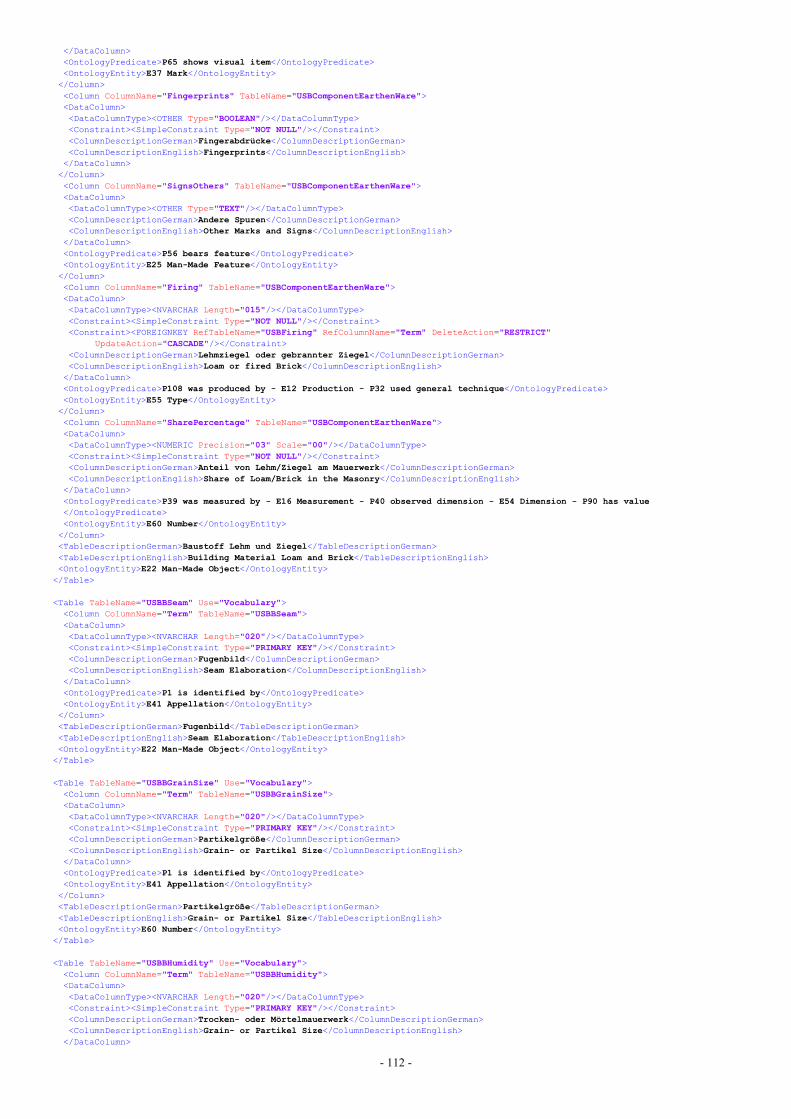
- 112 -
</DataColumn><OntologyPredicate>P65 shows visual item</OntologyPredicate><OntologyEntity>E37 Mark</OntologyEntity></Column><Column ColumnName="Fingerprints" TableName="USBComponentEarthenWare"><DataColumn><DataColumnType><OTHER Type="BOOLEAN"/></DataColumnType><Constraint><SimpleConstraint Type="NOT NULL"/></Constraint><ColumnDescriptionGerman>Fingerabdrücke</ColumnDescriptionGerman><ColumnDescriptionEnglish>Fingerprints</ColumnDescriptionEnglish>
</DataColumn></Column><Column ColumnName="SignsOthers" TableName="USBComponentEarthenWare"><DataColumn><DataColumnType><OTHER Type="TEXT"/></DataColumnType><ColumnDescriptionGerman>Andere Spuren</ColumnDescriptionGerman><ColumnDescriptionEnglish>Other Marks and Signs</ColumnDescriptionEnglish>
</DataColumn><OntologyPredicate>P56 bears feature</OntologyPredicate><OntologyEntity>E25 Man-Made Feature</OntologyEntity></Column><Column ColumnName="Firing" TableName="USBComponentEarthenWare"><DataColumn><DataColumnType><NVARCHAR Length="015"/></DataColumnType><Constraint><SimpleConstraint Type="NOT NULL"/></Constraint><Constraint><FOREIGNKEY RefTableName="USBFiring" RefColumnName="Term" DeleteAction="RESTRICT"
UpdateAction="CASCADE"/></Constraint><ColumnDescriptionGerman>Lehmziegel oder gebrannter Ziegel</ColumnDescriptionGerman><ColumnDescriptionEnglish>Loam or fired Brick</ColumnDescriptionEnglish>
</DataColumn><OntologyPredicate>P108 was produced by - E12 Production - P32 used general technique</OntologyPredicate><OntologyEntity>E55 Type</OntologyEntity></Column><Column ColumnName="SharePercentage" TableName="USBComponentEarthenWare"><DataColumn><DataColumnType><NUMERIC Precision="03" Scale="00"/></DataColumnType><Constraint><SimpleConstraint Type="NOT NULL"/></Constraint><ColumnDescriptionGerman>Anteil von Lehm/Ziegel am Mauerwerk</ColumnDescriptionGerman><ColumnDescriptionEnglish>Share of Loam/Brick in the Masonry</ColumnDescriptionEnglish>
</DataColumn><OntologyPredicate>P39 was measured by - E16 Measurement - P40 observed dimension - E54 Dimension - P90 has value</OntologyPredicate><OntologyEntity>E60 Number</OntologyEntity></Column><TableDescriptionGerman>Baustoff Lehm und Ziegel</TableDescriptionGerman><TableDescriptionEnglish>Building Material Loam and Brick</TableDescriptionEnglish><OntologyEntity>E22 Man-Made Object</OntologyEntity>
</Table>
<Table TableName="USBBSeam" Use="Vocabulary"><Column ColumnName="Term" TableName="USBBSeam"><DataColumn><DataColumnType><NVARCHAR Length="020"/></DataColumnType><Constraint><SimpleConstraint Type="PRIMARY KEY"/></Constraint><ColumnDescriptionGerman>Fugenbild</ColumnDescriptionGerman><ColumnDescriptionEnglish>Seam Elaboration</ColumnDescriptionEnglish>
</DataColumn><OntologyPredicate>P1 is identified by</OntologyPredicate><OntologyEntity>E41 Appellation</OntologyEntity></Column><TableDescriptionGerman>Fugenbild</TableDescriptionGerman><TableDescriptionEnglish>Seam Elaboration</TableDescriptionEnglish><OntologyEntity>E22 Man-Made Object</OntologyEntity>
</Table>
<Table TableName="USBBGrainSize" Use="Vocabulary"><Column ColumnName="Term" TableName="USBBGrainSize"><DataColumn><DataColumnType><NVARCHAR Length="020"/></DataColumnType><Constraint><SimpleConstraint Type="PRIMARY KEY"/></Constraint><ColumnDescriptionGerman>Partikelgröße</ColumnDescriptionGerman><ColumnDescriptionEnglish>Grain- or Partikel Size</ColumnDescriptionEnglish>
</DataColumn><OntologyPredicate>P1 is identified by</OntologyPredicate><OntologyEntity>E41 Appellation</OntologyEntity></Column><TableDescriptionGerman>Partikelgröße</TableDescriptionGerman><TableDescriptionEnglish>Grain- or Partikel Size</TableDescriptionEnglish><OntologyEntity>E60 Number</OntologyEntity>
</Table>
<Table TableName="USBBHumidity" Use="Vocabulary"><Column ColumnName="Term" TableName="USBBHumidity"><DataColumn><DataColumnType><NVARCHAR Length="020"/></DataColumnType><Constraint><SimpleConstraint Type="PRIMARY KEY"/></Constraint><ColumnDescriptionGerman>Trocken- oder Mörtelmauerwerk</ColumnDescriptionGerman><ColumnDescriptionEnglish>Grain- or Partikel Size</ColumnDescriptionEnglish>
</DataColumn>
- 113 -
<OntologyPredicate>P1 is identified by</OntologyPredicate><OntologyEntity>E41 Appellation</OntologyEntity></Column><TableDescriptionGerman>Trocken- oder Mörtelmauerwerk</TableDescriptionGerman><TableDescriptionEnglish>Dry Masonry or Mortar Masonry</TableDescriptionEnglish><OntologyEntity>E55 Type</OntologyEntity>
</Table>
<Table TableName="USBBMaterial" Use="Vocabulary"><Column ColumnName="Term" TableName="USBBMaterial"><DataColumn><DataColumnType><NVARCHAR Length="010"/></DataColumnType><Constraint><SimpleConstraint Type="PRIMARY KEY"/></Constraint><ColumnDescriptionGerman>Material</ColumnDescriptionGerman><ColumnDescriptionEnglish>Material</ColumnDescriptionEnglish>
</DataColumn><OntologyPredicate>P1 is identified by</OntologyPredicate><OntologyEntity>E41 Appellation</OntologyEntity></Column><Column ColumnName="Description" TableName="USBBMaterial"><DataColumn><DataColumnType><OTHER Type="TEXT"/></DataColumnType><ColumnDescriptionGerman>Beschreibung</ColumnDescriptionGerman><ColumnDescriptionEnglish>Description</ColumnDescriptionEnglish>
</DataColumn><OntologyPredicate>P3 has note</OntologyPredicate><OntologyEntity>E62 String</OntologyEntity></Column><TableDescriptionGerman>Material</TableDescriptionGerman><TableDescriptionEnglish>Material</TableDescriptionEnglish><OntologyEntity>E57 Material</OntologyEntity>
</Table>
<Table TableName="USBConsistency" Use="Vocabulary"><Column ColumnName="Term" TableName="USBConsistency"><DataColumn><DataColumnType><NVARCHAR Length="015"/></DataColumnType><Constraint><SimpleConstraint Type="PRIMARY KEY"/></Constraint><ColumnDescriptionGerman>Konsistenz</ColumnDescriptionGerman><ColumnDescriptionEnglish>Consistency</ColumnDescriptionEnglish>
</DataColumn><OntologyPredicate>P1 is identified by</OntologyPredicate><OntologyEntity>E41 Appellation</OntologyEntity></Column><TableDescriptionGerman>Konsistenz</TableDescriptionGerman><TableDescriptionEnglish>Consistency</TableDescriptionEnglish><OntologyEntity>E3 Condition State</OntologyEntity>
</Table>
<Table TableName="USBAdditive" Use="Vocabulary"><Column ColumnName="Term" TableName="USBAdditive"><DataColumn><DataColumnType><NVARCHAR Length="015"/></DataColumnType><Constraint><SimpleConstraint Type="PRIMARY KEY"/></Constraint><ColumnDescriptionGerman>Zuschlagstoffe</ColumnDescriptionGerman><ColumnDescriptionEnglish>Additives</ColumnDescriptionEnglish>
</DataColumn><OntologyPredicate>P1 is identified by</OntologyPredicate><OntologyEntity>E42 Identifier</OntologyEntity></Column><TableDescriptionGerman>Zuschlagstoffe</TableDescriptionGerman><TableDescriptionEnglish>Additives</TableDescriptionEnglish><OntologyEntity>E57 Material</OntologyEntity>
</Table>
<Table TableName="USBBinding" Use="Storage"><Column ColumnName="USNr" TableName="USBBinding"><DataColumn><DataColumnType><NUMERIC Precision="06" Scale="00"/></DataColumnType><Constraint><SimpleConstraint Type="PRIMARY KEY"/></Constraint><Constraint><FOREIGNKEY RefTableName="USBuilding" RefColumnName="USNr" DeleteAction="CASCADE"
UpdateAction="CASCADE"/></Constraint><ColumnDescriptionGerman>Kennnummer Stratifikationseinheit</ColumnDescriptionGerman><ColumnDescriptionEnglish>ID of the Unit of Stratification</ColumnDescriptionEnglish>
</DataColumn><OntologyPredicate>P1 is identified by</OntologyPredicate><OntologyEntity>E42 Identifier</OntologyEntity></Column><Column ColumnName="Humidity" TableName="USBBinding"><DataColumn><DataColumnType><NVARCHAR Length="010"/></DataColumnType><Constraint><SimpleConstraint Type="NOT NULL"/></Constraint><Constraint><FOREIGNKEY RefTableName="USBBHumidity" RefColumnName="Term" DeleteAction="RESTRICT"
UpdateAction="CASCADE"/></Constraint><ColumnDescriptionGerman>Trocken- oder Mörtelmauerwerk</ColumnDescriptionGerman><ColumnDescriptionEnglish>Dry Masonry or Mortar Masonry</ColumnDescriptionEnglish>
</DataColumn><OntologyPredicate>P108 was produced by - E12 Production - P32 used general technique</OntologyPredicate><OntologyEntity>E55 Type</OntologyEntity>
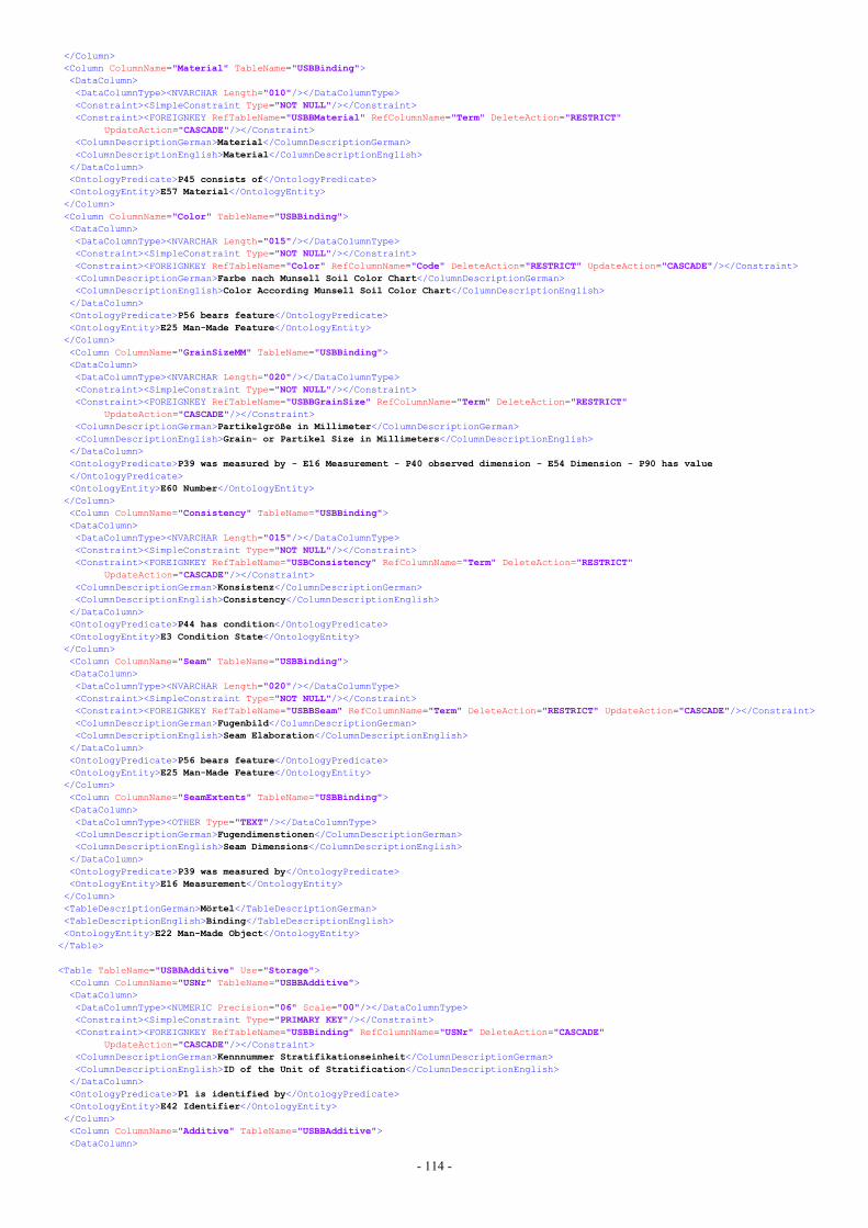
- 114 -
</Column><Column ColumnName="Material" TableName="USBBinding"><DataColumn><DataColumnType><NVARCHAR Length="010"/></DataColumnType><Constraint><SimpleConstraint Type="NOT NULL"/></Constraint><Constraint><FOREIGNKEY RefTableName="USBBMaterial" RefColumnName="Term" DeleteAction="RESTRICT"
UpdateAction="CASCADE"/></Constraint><ColumnDescriptionGerman>Material</ColumnDescriptionGerman><ColumnDescriptionEnglish>Material</ColumnDescriptionEnglish>
</DataColumn><OntologyPredicate>P45 consists of</OntologyPredicate><OntologyEntity>E57 Material</OntologyEntity></Column><Column ColumnName="Color" TableName="USBBinding"><DataColumn><DataColumnType><NVARCHAR Length="015"/></DataColumnType><Constraint><SimpleConstraint Type="NOT NULL"/></Constraint><Constraint><FOREIGNKEY RefTableName="Color" RefColumnName="Code" DeleteAction="RESTRICT" UpdateAction="CASCADE"/></Constraint><ColumnDescriptionGerman>Farbe nach Munsell Soil Color Chart</ColumnDescriptionGerman><ColumnDescriptionEnglish>Color According Munsell Soil Color Chart</ColumnDescriptionEnglish>
</DataColumn><OntologyPredicate>P56 bears feature</OntologyPredicate><OntologyEntity>E25 Man-Made Feature</OntologyEntity></Column><Column ColumnName="GrainSizeMM" TableName="USBBinding"><DataColumn><DataColumnType><NVARCHAR Length="020"/></DataColumnType><Constraint><SimpleConstraint Type="NOT NULL"/></Constraint><Constraint><FOREIGNKEY RefTableName="USBBGrainSize" RefColumnName="Term" DeleteAction="RESTRICT"
UpdateAction="CASCADE"/></Constraint><ColumnDescriptionGerman>Partikelgröße in Millimeter</ColumnDescriptionGerman><ColumnDescriptionEnglish>Grain- or Partikel Size in Millimeters</ColumnDescriptionEnglish>
</DataColumn><OntologyPredicate>P39 was measured by - E16 Measurement - P40 observed dimension - E54 Dimension - P90 has value</OntologyPredicate><OntologyEntity>E60 Number</OntologyEntity></Column><Column ColumnName="Consistency" TableName="USBBinding"><DataColumn><DataColumnType><NVARCHAR Length="015"/></DataColumnType><Constraint><SimpleConstraint Type="NOT NULL"/></Constraint><Constraint><FOREIGNKEY RefTableName="USBConsistency" RefColumnName="Term" DeleteAction="RESTRICT"
UpdateAction="CASCADE"/></Constraint><ColumnDescriptionGerman>Konsistenz</ColumnDescriptionGerman><ColumnDescriptionEnglish>Consistency</ColumnDescriptionEnglish>
</DataColumn><OntologyPredicate>P44 has condition</OntologyPredicate><OntologyEntity>E3 Condition State</OntologyEntity></Column><Column ColumnName="Seam" TableName="USBBinding"><DataColumn><DataColumnType><NVARCHAR Length="020"/></DataColumnType><Constraint><SimpleConstraint Type="NOT NULL"/></Constraint><Constraint><FOREIGNKEY RefTableName="USBBSeam" RefColumnName="Term" DeleteAction="RESTRICT" UpdateAction="CASCADE"/></Constraint><ColumnDescriptionGerman>Fugenbild</ColumnDescriptionGerman><ColumnDescriptionEnglish>Seam Elaboration</ColumnDescriptionEnglish>
</DataColumn><OntologyPredicate>P56 bears feature</OntologyPredicate><OntologyEntity>E25 Man-Made Feature</OntologyEntity></Column><Column ColumnName="SeamExtents" TableName="USBBinding"><DataColumn><DataColumnType><OTHER Type="TEXT"/></DataColumnType><ColumnDescriptionGerman>Fugendimenstionen</ColumnDescriptionGerman><ColumnDescriptionEnglish>Seam Dimensions</ColumnDescriptionEnglish>
</DataColumn><OntologyPredicate>P39 was measured by</OntologyPredicate><OntologyEntity>E16 Measurement</OntologyEntity></Column><TableDescriptionGerman>Mörtel</TableDescriptionGerman><TableDescriptionEnglish>Binding</TableDescriptionEnglish><OntologyEntity>E22 Man-Made Object</OntologyEntity>
</Table>
<Table TableName="USBBAdditive" Use="Storage"><Column ColumnName="USNr" TableName="USBBAdditive"><DataColumn><DataColumnType><NUMERIC Precision="06" Scale="00"/></DataColumnType><Constraint><SimpleConstraint Type="PRIMARY KEY"/></Constraint><Constraint><FOREIGNKEY RefTableName="USBBinding" RefColumnName="USNr" DeleteAction="CASCADE"
UpdateAction="CASCADE"/></Constraint><ColumnDescriptionGerman>Kennnummer Stratifikationseinheit</ColumnDescriptionGerman><ColumnDescriptionEnglish>ID of the Unit of Stratification</ColumnDescriptionEnglish>
</DataColumn><OntologyPredicate>P1 is identified by</OntologyPredicate><OntologyEntity>E42 Identifier</OntologyEntity></Column><Column ColumnName="Additive" TableName="USBBAdditive"><DataColumn>
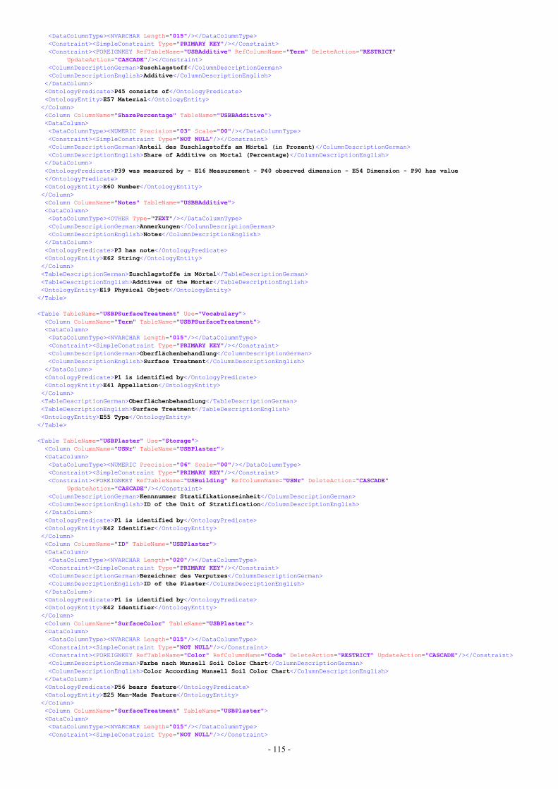
- 115 -
<DataColumnType><NVARCHAR Length="015"/></DataColumnType><Constraint><SimpleConstraint Type="PRIMARY KEY"/></Constraint><Constraint><FOREIGNKEY RefTableName="USBAdditive" RefColumnName="Term" DeleteAction="RESTRICT"
UpdateAction="CASCADE"/></Constraint><ColumnDescriptionGerman>Zuschlagstoff</ColumnDescriptionGerman><ColumnDescriptionEnglish>Additive</ColumnDescriptionEnglish>
</DataColumn><OntologyPredicate>P45 consists of</OntologyPredicate><OntologyEntity>E57 Material</OntologyEntity></Column><Column ColumnName="SharePercentage" TableName="USBBAdditive"><DataColumn><DataColumnType><NUMERIC Precision="03" Scale="00"/></DataColumnType><Constraint><SimpleConstraint Type="NOT NULL"/></Constraint><ColumnDescriptionGerman>Anteil des Zuschlagstoffs am Mörtel (in Prozent)</ColumnDescriptionGerman><ColumnDescriptionEnglish>Share of Additive on Mortal (Percentage)</ColumnDescriptionEnglish>
</DataColumn><OntologyPredicate>P39 was measured by - E16 Measurement - P40 observed dimension - E54 Dimension - P90 has value</OntologyPredicate><OntologyEntity>E60 Number</OntologyEntity></Column><Column ColumnName="Notes" TableName="USBBAdditive"><DataColumn><DataColumnType><OTHER Type="TEXT"/></DataColumnType><ColumnDescriptionGerman>Anmerkungen</ColumnDescriptionGerman><ColumnDescriptionEnglish>Notes</ColumnDescriptionEnglish>
</DataColumn><OntologyPredicate>P3 has note</OntologyPredicate><OntologyEntity>E62 String</OntologyEntity></Column><TableDescriptionGerman>Zuschlagstoffe im Mörtel</TableDescriptionGerman><TableDescriptionEnglish>Addtives of the Mortar</TableDescriptionEnglish><OntologyEntity>E19 Physical Object</OntologyEntity>
</Table>
<Table TableName="USBPSurfaceTreatment" Use="Vocabulary"><Column ColumnName="Term" TableName="USBPSurfaceTreatment"><DataColumn><DataColumnType><NVARCHAR Length="015"/></DataColumnType><Constraint><SimpleConstraint Type="PRIMARY KEY"/></Constraint><ColumnDescriptionGerman>Oberflächenbehandlung</ColumnDescriptionGerman><ColumnDescriptionEnglish>Surface Treatment</ColumnDescriptionEnglish>
</DataColumn><OntologyPredicate>P1 is identified by</OntologyPredicate><OntologyEntity>E41 Appellation</OntologyEntity></Column><TableDescriptionGerman>Oberflächenbehandlung</TableDescriptionGerman><TableDescriptionEnglish>Surface Treatment</TableDescriptionEnglish><OntologyEntity>E55 Type</OntologyEntity>
</Table>
<Table TableName="USBPlaster" Use="Storage"><Column ColumnName="USNr" TableName="USBPlaster"><DataColumn><DataColumnType><NUMERIC Precision="06" Scale="00"/></DataColumnType><Constraint><SimpleConstraint Type="PRIMARY KEY"/></Constraint><Constraint><FOREIGNKEY RefTableName="USBuilding" RefColumnName="USNr" DeleteAction="CASCADE"
UpdateAction="CASCADE"/></Constraint><ColumnDescriptionGerman>Kennnummer Stratifikationseinheit</ColumnDescriptionGerman><ColumnDescriptionEnglish>ID of the Unit of Stratification</ColumnDescriptionEnglish>
</DataColumn><OntologyPredicate>P1 is identified by</OntologyPredicate><OntologyEntity>E42 Identifier</OntologyEntity></Column><Column ColumnName="ID" TableName="USBPlaster"><DataColumn><DataColumnType><NVARCHAR Length="020"/></DataColumnType><Constraint><SimpleConstraint Type="PRIMARY KEY"/></Constraint><ColumnDescriptionGerman>Bezeichner des Verputzes</ColumnDescriptionGerman><ColumnDescriptionEnglish>ID of the Plaster</ColumnDescriptionEnglish>
</DataColumn><OntologyPredicate>P1 is identified by</OntologyPredicate><OntologyEntity>E42 Identifier</OntologyEntity></Column><Column ColumnName="SurfaceColor" TableName="USBPlaster"><DataColumn><DataColumnType><NVARCHAR Length="015"/></DataColumnType><Constraint><SimpleConstraint Type="NOT NULL"/></Constraint><Constraint><FOREIGNKEY RefTableName="Color" RefColumnName="Code" DeleteAction="RESTRICT" UpdateAction="CASCADE"/></Constraint><ColumnDescriptionGerman>Farbe nach Munsell Soil Color Chart</ColumnDescriptionGerman><ColumnDescriptionEnglish>Color According Munsell Soil Color Chart</ColumnDescriptionEnglish>
</DataColumn><OntologyPredicate>P56 bears feature</OntologyPredicate><OntologyEntity>E25 Man-Made Feature</OntologyEntity></Column><Column ColumnName="SurfaceTreatment" TableName="USBPlaster"><DataColumn><DataColumnType><NVARCHAR Length="015"/></DataColumnType><Constraint><SimpleConstraint Type="NOT NULL"/></Constraint>
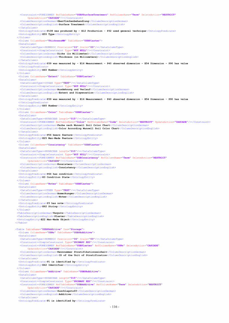
- 116 -
<Constraint><FOREIGNKEY RefTableName="USBPSurfaceTreatment" RefColumnName="Term" DeleteAction="RESTRICT"UpdateAction="CASCADE"/></Constraint>
<ColumnDescriptionGerman>Oberflächenbehandlung</ColumnDescriptionGerman><ColumnDescriptionEnglish>Surface Treatment</ColumnDescriptionEnglish>
</DataColumn><OntologyPredicate>P108 was produced by - E12 Production - P32 used general technique</OntologyPredicate><OntologyEntity>E55 Type</OntologyEntity></Column><Column ColumnName="ThicknessMM" TableName="USBPlaster"><DataColumn><DataColumnType><NUMERIC Precision="03" Scale="00"/></DataColumnType><Constraint><SimpleConstraint Type="NOT NULL"/></Constraint><ColumnDescriptionGerman>Dicke (in Millimeter)</ColumnDescriptionGerman><ColumnDescriptionEnglish>Thickness (in Millimeters)</ColumnDescriptionEnglish>
</DataColumn><OntologyPredicate>P39 was measured by - E16 Measurement - P40 observed dimension - E54 Dimension - P90 has value</OntologyPredicate><OntologyEntity>E60 Number</OntologyEntity></Column><Column ColumnName="Extent" TableName="USBPlaster"><DataColumn><DataColumnType><OTHER Type="TEXT"/></DataColumnType><Constraint><SimpleConstraint Type="NOT NULL"/></Constraint><ColumnDescriptionGerman>Ausdehnung und Verlauf</ColumnDescriptionGerman><ColumnDescriptionEnglish>Extent and Dispensation</ColumnDescriptionEnglish>
</DataColumn><OntologyPredicate>P39 was measured by - E16 Measurement - P40 observed dimension - E54 Dimension - P90 has value</OntologyPredicate><OntologyEntity>E60 Number</OntologyEntity></Column><Column ColumnName="Color" TableName="USBPlaster"><DataColumn><DataColumnType><NVARCHAR Length="015"/></DataColumnType><Constraint><FOREIGNKEY RefTableName="Color" RefColumnName="Code" DeleteAction="RESTRICT" UpdateAction="CASCADE"/></Constraint><ColumnDescriptionGerman>Farbe nach Munsell Soil Color Chart</ColumnDescriptionGerman><ColumnDescriptionEnglish>Color According Munsell Soil Color Chart</ColumnDescriptionEnglish>
</DataColumn><OntologyPredicate>P56 bears feature</OntologyPredicate><OntologyEntity>E25 Man-Made Feature</OntologyEntity></Column><Column ColumnName="Consistency" TableName="USBPlaster"><DataColumn><DataColumnType><NVARCHAR Length="015"/></DataColumnType><Constraint><SimpleConstraint Type="NOT NULL"/></Constraint><Constraint><FOREIGNKEY RefTableName="USBConsistency" RefColumnName="Term" DeleteAction="RESTRICT"
UpdateAction="CASCADE"/></Constraint><ColumnDescriptionGerman>Konsistenz</ColumnDescriptionGerman><ColumnDescriptionEnglish>Consistency</ColumnDescriptionEnglish>
</DataColumn><OntologyPredicate>P44 has condition</OntologyPredicate><OntologyEntity>E3 Condition State</OntologyEntity></Column><Column ColumnName="Notes" TableName="USBPlaster"><DataColumn><DataColumnType><OTHER Type="TEXT"/></DataColumnType><ColumnDescriptionGerman>Anmerkungen</ColumnDescriptionGerman><ColumnDescriptionEnglish>Notes</ColumnDescriptionEnglish>
</DataColumn><OntologyPredicate>P3 has note</OntologyPredicate><OntologyEntity>E62 String</OntologyEntity></Column><TableDescriptionGerman>Verputz</TableDescriptionGerman><TableDescriptionEnglish>Plaster</TableDescriptionEnglish><OntologyEntity>E22 Man-Made Object</OntologyEntity>
</Table>
<Table TableName="USBPAdditive" Use="Storage"><Column ColumnName="USNr" TableName="USBPAdditive"><DataColumn><DataColumnType><NUMERIC Precision="06" Scale="00"/></DataColumnType><Constraint><SimpleConstraint Type="PRIMARY KEY"/></Constraint><Constraint><FOREIGNKEY RefTableName="USBPlaster" RefColumnName="USNr" DeleteAction="CASCADE"
UpdateAction="CASCADE"/></Constraint><ColumnDescriptionGerman>Kennnummer Stratifikationseinheit</ColumnDescriptionGerman><ColumnDescriptionEnglish>ID of the Unit of Stratification</ColumnDescriptionEnglish>
</DataColumn><OntologyPredicate>P1 is identified by</OntologyPredicate><OntologyEntity>E42 Identifier</OntologyEntity></Column><Column ColumnName="Additive" TableName="USBPAdditive"><DataColumn><DataColumnType><NVARCHAR Length="015"/></DataColumnType><Constraint><SimpleConstraint Type="PRIMARY KEY"/></Constraint><Constraint><FOREIGNKEY RefTableName="USBAdditive" RefColumnName="Term" DeleteAction="RESTRICT"
UpdateAction="CASCADE"/></Constraint><ColumnDescriptionGerman>Zuschlagstoff</ColumnDescriptionGerman><ColumnDescriptionEnglish>Additive</ColumnDescriptionEnglish>
</DataColumn><OntologyPredicate>P1 is identified by</OntologyPredicate>
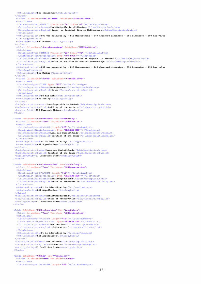
- 117 -
<OntologyEntity>E42 Identifier</OntologyEntity></Column><Column ColumnName="GrainSizeMM" TableName="USBPAdditive"><DataColumn><DataColumnType><NUMERIC Precision="04" Scale="02"/></DataColumnType><ColumnDescriptionGerman>Partikelgröße in Millimeter</ColumnDescriptionGerman><ColumnDescriptionEnglish>Grain- or Partikel Size in Millimeters</ColumnDescriptionEnglish>
</DataColumn><OntologyPredicate>P39 was measured by - E16 Measurement - P40 observed dimension - E54 Dimension - P90 has value</OntologyPredicate><OntologyEntity>E60 Number</OntologyEntity></Column><Column ColumnName="SharePercentage" TableName="USBPAdditive"><DataColumn><DataColumnType><NUMERIC Precision="03" Scale="00"/></DataColumnType><Constraint><SimpleConstraint Type="NOT NULL"/></Constraint><ColumnDescriptionGerman>Anteil des Zuschlagstoffs am Verputz (in Prozent)</ColumnDescriptionGerman><ColumnDescriptionEnglish>Share of Additive on Plaster (Percentage)</ColumnDescriptionEnglish>
</DataColumn><OntologyPredicate>P39 was measured by - E16 Measurement - P40 observed dimension - E54 Dimension - P90 has value</OntologyPredicate><OntologyEntity>E60 Number</OntologyEntity></Column><Column ColumnName="Notes" TableName="USBPAdditive"><DataColumn><DataColumnType><OTHER Type="TEXT"/></DataColumnType><ColumnDescriptionGerman>Anmerkungen</ColumnDescriptionGerman><ColumnDescriptionEnglish>Notes</ColumnDescriptionEnglish>
</DataColumn><OntologyPredicate>P3 has note</OntologyPredicate><OntologyEntity>E62 String</OntologyEntity></Column><TableDescriptionGerman>Zuschlagstoffe im Mörtel</TableDescriptionGerman><TableDescriptionEnglish>Addtives of the Mortar</TableDescriptionEnglish><OntologyEntity>E19 Physical Object</OntologyEntity>
</Table>
<Table TableName="USHPosition" Use="Vocabulary"><Column ColumnName="Term" TableName="USHPosition"><DataColumn><DataColumnType><NVARCHAR Length="020"/></DataColumnType><Constraint><SimpleConstraint Type="PRIMARY KEY"/></Constraint><ColumnDescriptionGerman>Lage der Skelettfunde</ColumnDescriptionGerman><ColumnDescriptionEnglish>Position of the Bones</ColumnDescriptionEnglish>
</DataColumn><OntologyPredicate>P1 is identified by</OntologyPredicate><OntologyEntity>E41 Appellation</OntologyEntity></Column><TableDescriptionGerman>Lage der Skelettfunde</TableDescriptionGerman><TableDescriptionEnglish>Position of the Bones</TableDescriptionEnglish><OntologyEntity>E3 Condition State</OntologyEntity>
</Table>
<Table TableName="USHPreservation" Use="Vocabulary"><Column ColumnName="Term" TableName="USHPreservation"><DataColumn><DataColumnType><NVARCHAR Length="015"/></DataColumnType><Constraint><SimpleConstraint Type="PRIMARY KEY"/></Constraint><ColumnDescriptionGerman>Erhaltungszustand</ColumnDescriptionGerman><ColumnDescriptionEnglish>State of Preservation</ColumnDescriptionEnglish>
</DataColumn><OntologyPredicate>P1 is identified by</OntologyPredicate><OntologyEntity>E41 Appellation</OntologyEntity></Column><TableDescriptionGerman>Erhaltungszustand</TableDescriptionGerman><TableDescriptionEnglish>State of Preservation</TableDescriptionEnglish><OntologyEntity>E3 Condition State</OntologyEntity>
</Table>
<Table TableName="USHDislocation" Use="Vocabulary"><Column ColumnName="Term" TableName="USHDislocation"><DataColumn><DataColumnType><NVARCHAR Length="015"/></DataColumnType><Constraint><SimpleConstraint Type="PRIMARY KEY"/></Constraint><ColumnDescriptionGerman>Dislokation</ColumnDescriptionGerman><ColumnDescriptionEnglish>Dislocation</ColumnDescriptionEnglish>
</DataColumn><OntologyPredicate>P1 is identified by</OntologyPredicate><OntologyEntity>E41 Appellation</OntologyEntity></Column><TableDescriptionGerman>Dislokation</TableDescriptionGerman><TableDescriptionEnglish>Dislocation</TableDescriptionEnglish><OntologyEntity>E3 Condition State</OntologyEntity>
</Table>
<Table TableName="USHAge" Use="Vocabulary"><Column ColumnName="Term" TableName="USHAge"><DataColumn><DataColumnType><NVARCHAR Length="008"/></DataColumnType>
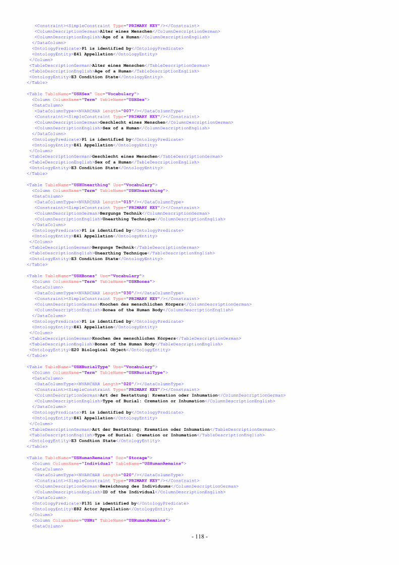
- 118 -
<Constraint><SimpleConstraint Type="PRIMARY KEY"/></Constraint><ColumnDescriptionGerman>Alter eines Menschen</ColumnDescriptionGerman><ColumnDescriptionEnglish>Age of a Human</ColumnDescriptionEnglish>
</DataColumn><OntologyPredicate>P1 is identified by</OntologyPredicate><OntologyEntity>E41 Appellation</OntologyEntity></Column><TableDescriptionGerman>Alter eines Menschen</TableDescriptionGerman><TableDescriptionEnglish>Age of a Human</TableDescriptionEnglish><OntologyEntity>E3 Condition State</OntologyEntity>
</Table>
<Table TableName="USHSex" Use="Vocabulary"><Column ColumnName="Term" TableName="USHSex"><DataColumn><DataColumnType><NVARCHAR Length="007"/></DataColumnType><Constraint><SimpleConstraint Type="PRIMARY KEY"/></Constraint><ColumnDescriptionGerman>Geschlecht eines Menschen</ColumnDescriptionGerman><ColumnDescriptionEnglish>Sex of a Human</ColumnDescriptionEnglish>
</DataColumn><OntologyPredicate>P1 is identified by</OntologyPredicate><OntologyEntity>E41 Appellation</OntologyEntity></Column><TableDescriptionGerman>Geschlecht eines Menschen</TableDescriptionGerman><TableDescriptionEnglish>Sex of a Human</TableDescriptionEnglish><OntologyEntity>E3 Condition State</OntologyEntity>
</Table>
<Table TableName="USHUnearthing" Use="Vocabulary"><Column ColumnName="Term" TableName="USHUnearthing"><DataColumn><DataColumnType><NVARCHAR Length="015"/></DataColumnType><Constraint><SimpleConstraint Type="PRIMARY KEY"/></Constraint><ColumnDescriptionGerman>Bergungs Technik</ColumnDescriptionGerman><ColumnDescriptionEnglish>Unearthing Technique</ColumnDescriptionEnglish>
</DataColumn><OntologyPredicate>P1 is identified by</OntologyPredicate><OntologyEntity>E41 Appellation</OntologyEntity></Column><TableDescriptionGerman>Bergungs Technik</TableDescriptionGerman><TableDescriptionEnglish>Unearthing Technique</TableDescriptionEnglish><OntologyEntity>E3 Condition State</OntologyEntity>
</Table>
<Table TableName="USHBones" Use="Vocabulary"><Column ColumnName="Term" TableName="USHBones"><DataColumn><DataColumnType><NVARCHAR Length="030"/></DataColumnType><Constraint><SimpleConstraint Type="PRIMARY KEY"/></Constraint><ColumnDescriptionGerman>Knochen des menschlichen Körpers</ColumnDescriptionGerman><ColumnDescriptionEnglish>Bones of the Human Body</ColumnDescriptionEnglish>
</DataColumn><OntologyPredicate>P1 is identified by</OntologyPredicate><OntologyEntity>E41 Appellation</OntologyEntity></Column><TableDescriptionGerman>Knochen des menschlichen Körpers</TableDescriptionGerman><TableDescriptionEnglish>Bones of the Human Body</TableDescriptionEnglish><OntologyEntity>E20 Biological Object</OntologyEntity>
</Table>
<Table TableName="USHBurialType" Use="Vocabulary"><Column ColumnName="Term" TableName="USHBurialType"><DataColumn><DataColumnType><NVARCHAR Length="020"/></DataColumnType><Constraint><SimpleConstraint Type="PRIMARY KEY"/></Constraint><ColumnDescriptionGerman>Art der Bestattung: Kremation oder Inhumation</ColumnDescriptionGerman><ColumnDescriptionEnglish>Type of Burial: Cremation or Inhumation</ColumnDescriptionEnglish>
</DataColumn><OntologyPredicate>P1 is identified by</OntologyPredicate><OntologyEntity>E41 Appellation</OntologyEntity></Column><TableDescriptionGerman>Art der Bestattung: Kremation oder Inhumation</TableDescriptionGerman><TableDescriptionEnglish>Type of Burial: Cremation or Inhumation</TableDescriptionEnglish><OntologyEntity>E3 Condtion State</OntologyEntity>
</Table>
<Table TableName="USHumanRemains" Use="Storage"><Column ColumnName="Individual" TableName="USHumanRemains"><DataColumn><DataColumnType><NVARCHAR Length="020"/></DataColumnType><Constraint><SimpleConstraint Type="PRIMARY KEY"/></Constraint><ColumnDescriptionGerman>Bezeichnung des Individuums</ColumnDescriptionGerman><ColumnDescriptionEnglish>ID of the Individual</ColumnDescriptionEnglish>
</DataColumn><OntologyPredicate>P131 is identified by</OntologyPredicate><OntologyEntity>E82 Actor Appellation</OntologyEntity></Column><Column ColumnName="USNr" TableName="USHumanRemains"><DataColumn>
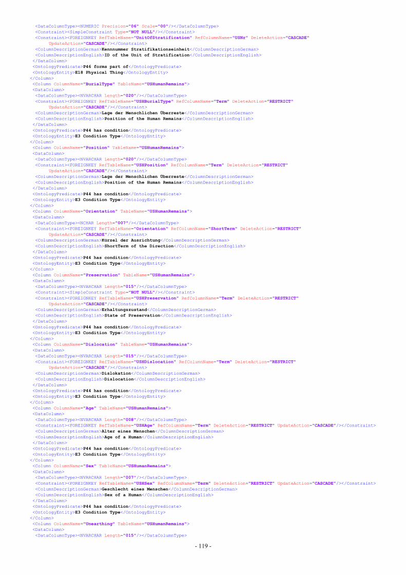
- 119 -
<DataColumnType><NUMERIC Precision="06" Scale="00"/></DataColumnType><Constraint><SimpleConstraint Type="NOT NULL"/></Constraint><Constraint><FOREIGNKEY RefTableName="UnitOfStratification" RefColumnName="USNr" DeleteAction="CASCADE"
UpdateAction="CASCADE"/></Constraint><ColumnDescriptionGerman>Kennnummer Stratifikationseinheit</ColumnDescriptionGerman><ColumnDescriptionEnglish>ID of the Unit of Stratification</ColumnDescriptionEnglish>
</DataColumn><OntologyPredicate>P46 forms part of</OntologyPredicate><OntologyEntity>E18 Physical Thing</OntologyEntity></Column><Column ColumnName="BurialType" TableName="USHumanRemains"><DataColumn><DataColumnType><NVARCHAR Length="020"/></DataColumnType><Constraint><FOREIGNKEY RefTableName="USHBurialType" RefColumnName="Term" DeleteAction="RESTRICT"
UpdateAction="CASCADE"/></Constraint><ColumnDescriptionGerman>Lage der Menschlichen Überreste</ColumnDescriptionGerman><ColumnDescriptionEnglish>Position of the Human Remains</ColumnDescriptionEnglish>
</DataColumn><OntologyPredicate>P44 has condition</OntologyPredicate><OntologyEntity>E3 Condition Type</OntologyEntity></Column><Column ColumnName="Position" TableName="USHumanRemains"><DataColumn><DataColumnType><NVARCHAR Length="020"/></DataColumnType><Constraint><FOREIGNKEY RefTableName="USHPosition" RefColumnName="Term" DeleteAction="RESTRICT"
UpdateAction="CASCADE"/></Constraint><ColumnDescriptionGerman>Lage der Menschlichen Überreste</ColumnDescriptionGerman><ColumnDescriptionEnglish>Position of the Human Remains</ColumnDescriptionEnglish>
</DataColumn><OntologyPredicate>P44 has condition</OntologyPredicate><OntologyEntity>E3 Condition Type</OntologyEntity></Column><Column ColumnName="Orientation" TableName="USHumanRemains"><DataColumn><DataColumnType><NCHAR Length="007"/></DataColumnType><Constraint><FOREIGNKEY RefTableName="Orientation" RefColumnName="ShortTerm" DeleteAction="RESTRICT"
UpdateAction="CASCADE"/></Constraint><ColumnDescriptionGerman>Kürzel der Ausrichtung</ColumnDescriptionGerman><ColumnDescriptionEnglish>ShortTerm of the Direction</ColumnDescriptionEnglish>
</DataColumn><OntologyPredicate>P44 has condition</OntologyPredicate><OntologyEntity>E3 Condition Type</OntologyEntity></Column><Column ColumnName="Preservation" TableName="USHumanRemains"><DataColumn><DataColumnType><NVARCHAR Length="015"/></DataColumnType><Constraint><SimpleConstraint Type="NOT NULL"/></Constraint><Constraint><FOREIGNKEY RefTableName="USHPreservation" RefColumnName="Term" DeleteAction="RESTRICT"
UpdateAction="CASCADE"/></Constraint><ColumnDescriptionGerman>Erhaltungszustand</ColumnDescriptionGerman><ColumnDescriptionEnglish>State of Preservation</ColumnDescriptionEnglish>
</DataColumn><OntologyPredicate>P44 has condition</OntologyPredicate><OntologyEntity>E3 Condition Type</OntologyEntity></Column><Column ColumnName="Dislocation" TableName="USHumanRemains"><DataColumn><DataColumnType><NVARCHAR Length="015"/></DataColumnType><Constraint><FOREIGNKEY RefTableName="USHDislocation" RefColumnName="Term" DeleteAction="RESTRICT"
UpdateAction="CASCADE"/></Constraint><ColumnDescriptionGerman>Dislokation</ColumnDescriptionGerman><ColumnDescriptionEnglish>Dislocation</ColumnDescriptionEnglish>
</DataColumn><OntologyPredicate>P44 has condition</OntologyPredicate><OntologyEntity>E3 Condition Type</OntologyEntity></Column><Column ColumnName="Age" TableName="USHumanRemains"><DataColumn><DataColumnType><NVARCHAR Length="008"/></DataColumnType><Constraint><FOREIGNKEY RefTableName="USHAge" RefColumnName="Term" DeleteAction="RESTRICT" UpdateAction="CASCADE"/></Constraint><ColumnDescriptionGerman>Alter eines Menschen</ColumnDescriptionGerman><ColumnDescriptionEnglish>Age of a Human</ColumnDescriptionEnglish>
</DataColumn><OntologyPredicate>P44 has condition</OntologyPredicate><OntologyEntity>E3 Condition Type</OntologyEntity></Column><Column ColumnName="Sex" TableName="USHumanRemains"><DataColumn><DataColumnType><NVARCHAR Length="007"/></DataColumnType><Constraint><FOREIGNKEY RefTableName="USHSex" RefColumnName="Term" DeleteAction="RESTRICT" UpdateAction="CASCADE"/></Constraint><ColumnDescriptionGerman>Geschlecht eines Menschen</ColumnDescriptionGerman><ColumnDescriptionEnglish>Sex of a Human</ColumnDescriptionEnglish>
</DataColumn><OntologyPredicate>P44 has condition</OntologyPredicate><OntologyEntity>E3 Condition Type</OntologyEntity></Column><Column ColumnName="Unearthing" TableName="USHumanRemains"><DataColumn><DataColumnType><NVARCHAR Length="015"/></DataColumnType>

- 120 -
<Constraint><SimpleConstraint Type="NOT NULL"/></Constraint><Constraint><FOREIGNKEY RefTableName="USHUnearthing" RefColumnName="Term" DeleteAction="RESTRICT"
UpdateAction="CASCADE"/></Constraint><ColumnDescriptionGerman>Bergungs Technik</ColumnDescriptionGerman><ColumnDescriptionEnglish>Unearthing Technique</ColumnDescriptionEnglish>
</DataColumn><OntologyPredicate>P44 has condition</OntologyPredicate><OntologyEntity>E3 Condition Type</OntologyEntity></Column><Column ColumnName="Notes" TableName="USHumanRemains"><DataColumn><DataColumnType><OTHER Type="TEXT"/></DataColumnType><ColumnDescriptionGerman>Anmerkungen</ColumnDescriptionGerman><ColumnDescriptionEnglish>Notes</ColumnDescriptionEnglish>
</DataColumn><OntologyPredicate>P3 has note</OntologyPredicate><OntologyEntity>E62 String</OntologyEntity></Column><Column ColumnName="PrelimDeposDateFrom" TableName="USHumanRemains"><DataColumn><DataColumnType><OTHER Type="DATE"/></DataColumnType><ColumnDescriptionGerman>Datierung der Grablegung von (JJJJ-MM-DD)</ColumnDescriptionGerman><ColumnDescriptionEnglish>Dating of Burial from (JJJJ-MM-DD)</ColumnDescriptionEnglish>
</DataColumn><OntologyPredicate>P25 moved by - E9 Move - P4 has time-span - E52 Time-Span - P79 beginning is qualified by</OntologyPredicate><OntologyEntity>E62 String</OntologyEntity></Column><Column ColumnName="PrelimDeposDateTo" TableName="USHumanRemains"><DataColumn><DataColumnType><OTHER Type="DATE"/></DataColumnType><ColumnDescriptionGerman>Datierung der Grablegung bis (JJJJ-MM-DD)</ColumnDescriptionGerman><ColumnDescriptionEnglish>Dating of Burial to (JJJJ-MM-DD)</ColumnDescriptionEnglish>
</DataColumn><OntologyPredicate>P25 moved by - E9 Move - P4 has time-span - E52 Time-Span - P80 end is qualified by</OntologyPredicate><OntologyEntity>E62 String</OntologyEntity></Column><Column ColumnName="Location" TableName="USHumanRemains"><SpatialColumn Dimension="XYZ" Nullable="0">POLYGON</SpatialColumn><OntologyPredicate>P156 occupies - E53 Place - 168 place is defined by</OntologyPredicate><OntologyEntity>E94 Space Primitive</OntologyEntity></Column><Column ColumnName="DrawingSVG" TableName="USHumanRemains"><DataColumn><DataColumnType><OTHER Type="TEXT"/></DataColumnType><ColumnDescriptionGerman>SVG Zeichnung</ColumnDescriptionGerman><ColumnDescriptionEnglish>SVG Drawing</ColumnDescriptionEnglish>
</DataColumn><OntologyPredicate>P156 occupies - E53 Place - 168 place is defined by</OntologyPredicate><OntologyEntity>E38 Image</OntologyEntity></Column><TableDescriptionGerman>Menschliche Überreste</TableDescriptionGerman><TableDescriptionEnglish>Human Remains</TableDescriptionEnglish><OntologyEntity>E21 Person</OntologyEntity>
</Table>
<Table TableName="USHBone" Use="Storage"><Column ColumnName="Individual" TableName="USHBone"><DataColumn><DataColumnType><NVARCHAR Length="020"/></DataColumnType><Constraint><SimpleConstraint Type="PRIMARY KEY"/></Constraint><Constraint><SimpleConstraint Type="NOT NULL"/></Constraint><Constraint><FOREIGNKEY RefTableName="USHumanRemains" RefColumnName="Individual" DeleteAction="CASCADE"
UpdateAction="CASCADE"/></Constraint><ColumnDescriptionGerman>Bezeichnung des Individuums</ColumnDescriptionGerman><ColumnDescriptionEnglish>ID of the Individual</ColumnDescriptionEnglish>
</DataColumn><OntologyEntity>E21 Person</OntologyEntity></Column><Column ColumnName="Term" TableName="USHBone"><DataColumn><DataColumnType><NVARCHAR Length="030"/></DataColumnType><Constraint><SimpleConstraint Type="PRIMARY KEY"/></Constraint><Constraint><SimpleConstraint Type="NOT NULL"/></Constraint><Constraint><FOREIGNKEY RefTableName="USHBones" RefColumnName="Term" DeleteAction="RESTRICT" UpdateAction="CASCADE"/></Constraint><ColumnDescriptionGerman>Knochen des menschlichen Körpers</ColumnDescriptionGerman><ColumnDescriptionEnglish>Bones of the Human Body</ColumnDescriptionEnglish>
</DataColumn><OntologyEntity>E20 Biological Object</OntologyEntity></Column><TableDescriptionGerman>Verknüpfungstabelle von Individuum und Knochen</TableDescriptionGerman><TableDescriptionEnglish>Linkage Table of Individual and Bone</TableDescriptionEnglish><OntologyPredicate>P46 is composed of</OntologyPredicate>
</Table>
<Table TableName="Find" Use="Storage"><Column ColumnName="USNr" TableName="Find"><DataColumn><DataColumnType><NUMERIC Precision="06" Scale="00"/></DataColumnType><Constraint><SimpleConstraint Type="NOT NULL"/></Constraint>
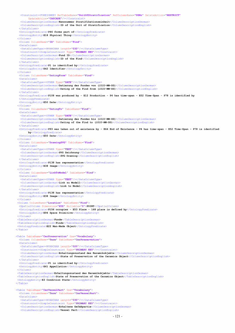
- 121 -
<Constraint><FOREIGNKEY RefTableName="UnitOfStratification" RefColumnName="USNr" DeleteAction="RESTRICT"UpdateAction="CASCADE"/></Constraint>
<ColumnDescriptionGerman>Kennnummer Stratifikationseinheit</ColumnDescriptionGerman><ColumnDescriptionEnglish>ID of the Unit of Stratification</ColumnDescriptionEnglish>
</DataColumn><OntologyPredicate>P46 forms part of</OntologyPredicate><OntologyEntity>E18 Physical Thing</OntologyEntity></Column><Column ColumnName="ID" TableName="Find"><DataColumn><DataColumnType><NVARCHAR Length="030"/></DataColumnType><Constraint><SimpleConstraint Type="PRIMARY KEY"/></Constraint><ColumnDescriptionGerman>Fund ID</ColumnDescriptionGerman><ColumnDescriptionEnglish>ID of the Find</ColumnDescriptionEnglish>
</DataColumn><OntologyPredicate>P1 is identified by</OntologyPredicate><OntologyEntity>E42 Identifier</OntologyEntity></Column><Column ColumnName="DatingFrom" TableName="Find"><DataColumn><DataColumnType><OTHER Type="DATE"/></DataColumnType><ColumnDescriptionGerman>Datierung des Fundes von (JJJJ-MM-DD)</ColumnDescriptionGerman><ColumnDescriptionEnglish>Dating of the Find from (JJJJ-MM-DD)</ColumnDescriptionEnglish>
</DataColumn><OntologyPredicate>P108 was produced by - E12 Production - P4 has time-span - E52 Time-Span - P78 is identified by</OntologyPredicate><OntologyEntity>E50 Date</OntologyEntity></Column><Column ColumnName="DatingTo" TableName="Find"><DataColumn><DataColumnType><OTHER Type="DATE"/></DataColumnType><ColumnDescriptionGerman>Datierung des Fundes bis (JJJJ-MM-DD)</ColumnDescriptionGerman><ColumnDescriptionEnglish>Dating of the Find to (JJJJ-MM-DD)</ColumnDescriptionEnglish>
</DataColumn><OntologyPredicate>P93 was taken out of existence by - E64 End of Existence - P4 has time-span - E52 Time-Span - P78 is identified
by</OntologyPredicate><OntologyEntity>E50 Date</OntologyEntity></Column><Column ColumnName="DrawingSVG" TableName="Find"><DataColumn><DataColumnType><OTHER Type="TEXT"/></DataColumnType><ColumnDescriptionGerman>SVG Zeichnung</ColumnDescriptionGerman><ColumnDescriptionEnglish>SVG Drawing</ColumnDescriptionEnglish>
</DataColumn><OntologyPredicate>P138 has representation</OntologyPredicate><OntologyEntity>E38 Image</OntologyEntity></Column><Column ColumnName="LinkToModel" TableName="Find"><DataColumn><DataColumnType><OTHER Type="TEXT"/></DataColumnType><ColumnDescriptionGerman>Link zu Modell</ColumnDescriptionGerman><ColumnDescriptionEnglish>Link to Model</ColumnDescriptionEnglish>
</DataColumn><OntologyPredicate>P138 has representation</OntologyPredicate><OntologyEntity>E38 Image</OntologyEntity></Column><Column ColumnName="Location" TableName="Find"><SpatialColumn Dimension="XYZ" Nullable="0">POINT</SpatialColumn><OntologyPredicate>P156 occupies - E53 Place - 168 place is defined by</OntologyPredicate><OntologyEntity>E94 Space Primitive</OntologyEntity></Column><TableDescriptionGerman>Funde</TableDescriptionGerman><TableDescriptionEnglish>Finds</TableDescriptionEnglish><OntologyPredicate>E22 Man-Made Object</OntologyPredicate>
</Table>
<Table TableName="CerPreservation" Use="Vocabulary"><Column ColumnName="Term" TableName="CerPreservation"><DataColumn><DataColumnType><NVARCHAR Length="020"/></DataColumnType><Constraint><SimpleConstraint Type="PRIMARY KEY"/></Constraint><ColumnDescriptionGerman>Erhaltungszustand des Keramikobjekts</ColumnDescriptionGerman><ColumnDescriptionEnglish>State of Preservation of the Ceramics Object</ColumnDescriptionEnglish>
</DataColumn><OntologyPredicate>P1 is identified by</OntologyPredicate><OntologyEntity>E41 Appellation</OntologyEntity></Column><TableDescriptionGerman>Erhaltungszustand des Keramikobjekts</TableDescriptionGerman><TableDescriptionEnglish>State of Preservation of the Ceramics Object</TableDescriptionEnglish><OntologyEntity>E3 Condition State</OntologyEntity>
</Table>
<Table TableName="CerVesselPart" Use="Vocabulary"><Column ColumnName="Term" TableName="CerVesselPart"><DataColumn><DataColumnType><NVARCHAR Length="030"/></DataColumnType><Constraint><SimpleConstraint Type="PRIMARY KEY"/></Constraint><ColumnDescriptionGerman>Erhaltene Gefäßpartie</ColumnDescriptionGerman><ColumnDescriptionEnglish>Vessel Part</ColumnDescriptionEnglish>
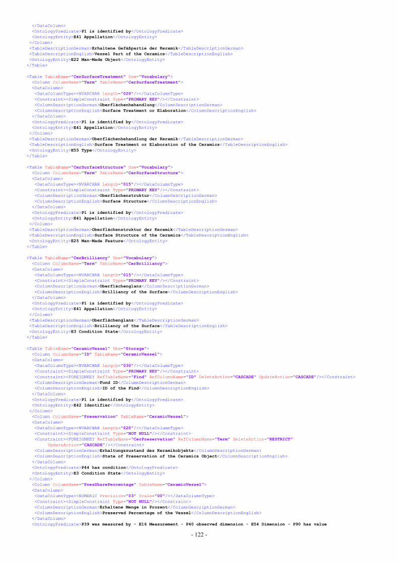
- 122 -
</DataColumn><OntologyPredicate>P1 is identified by</OntologyPredicate><OntologyEntity>E41 Appellation</OntologyEntity></Column><TableDescriptionGerman>Erhaltene Gefäßpartie der Keramik</TableDescriptionGerman><TableDescriptionEnglish>Vessel Part of the Ceramics</TableDescriptionEnglish><OntologyEntity>E22 Man-Made Object</OntologyEntity>
</Table>
<Table TableName="CerSurfaceTreatment" Use="Vocabulary"><Column ColumnName="Term" TableName="CerSurfaceTreatment"><DataColumn><DataColumnType><NVARCHAR Length="020"/></DataColumnType><Constraint><SimpleConstraint Type="PRIMARY KEY"/></Constraint><ColumnDescriptionGerman>Oberflächenhehandlung</ColumnDescriptionGerman><ColumnDescriptionEnglish>Surface Treatment or Elaboration</ColumnDescriptionEnglish>
</DataColumn><OntologyPredicate>P1 is identified by</OntologyPredicate><OntologyEntity>E41 Appellation</OntologyEntity></Column><TableDescriptionGerman>Oberflächenhehandlung der Keramik</TableDescriptionGerman><TableDescriptionEnglish>Surface Treatment or Elaboration of the Ceramics</TableDescriptionEnglish><OntologyEntity>E55 Type</OntologyEntity>
</Table>
<Table TableName="CerSurfaceStructure" Use="Vocabulary"><Column ColumnName="Term" TableName="CerSurfaceStructure"><DataColumn><DataColumnType><NVARCHAR Length="015"/></DataColumnType><Constraint><SimpleConstraint Type="PRIMARY KEY"/></Constraint><ColumnDescriptionGerman>Oberflächenstruktur</ColumnDescriptionGerman><ColumnDescriptionEnglish>Surface Structure</ColumnDescriptionEnglish>
</DataColumn><OntologyPredicate>P1 is identified by</OntologyPredicate><OntologyEntity>E41 Appellation</OntologyEntity></Column><TableDescriptionGerman>Oberflächenstruktur der Keramik</TableDescriptionGerman><TableDescriptionEnglish>Surface Structure of the Ceramics</TableDescriptionEnglish><OntologyEntity>E25 Man-Made Feature</OntologyEntity>
</Table>
<Table TableName="CerBrilliancy" Use="Vocabulary"><Column ColumnName="Term" TableName="CerBrilliancy"><DataColumn><DataColumnType><NVARCHAR Length="015"/></DataColumnType><Constraint><SimpleConstraint Type="PRIMARY KEY"/></Constraint><ColumnDescriptionGerman>Oberflächenglanz</ColumnDescriptionGerman><ColumnDescriptionEnglish>Brilliancy of the Surface</ColumnDescriptionEnglish>
</DataColumn><OntologyPredicate>P1 is identified by</OntologyPredicate><OntologyEntity>E41 Appellation</OntologyEntity></Column><TableDescriptionGerman>Oberflächenglanz</TableDescriptionGerman><TableDescriptionEnglish>Brilliancy of the Surface</TableDescriptionEnglish><OntologyEntity>E3 Condition State</OntologyEntity>
</Table>
<Table TableName="CeramicVessel" Use="Storage"><Column ColumnName="ID" TableName="CeramicVessel"><DataColumn><DataColumnType><NVARCHAR Length="030"/></DataColumnType><Constraint><SimpleConstraint Type="PRIMARY KEY"/></Constraint><Constraint><FOREIGNKEY RefTableName="Find" RefColumnName="ID" DeleteAction="CASCADE" UpdateAction="CASCADE"/></Constraint><ColumnDescriptionGerman>Fund ID</ColumnDescriptionGerman><ColumnDescriptionEnglish>ID of the Find</ColumnDescriptionEnglish>
</DataColumn><OntologyPredicate>P1 is identified by</OntologyPredicate><OntologyEntity>E42 Identifier</OntologyEntity></Column><Column ColumnName="Preservation" TableName="CeramicVessel"><DataColumn><DataColumnType><NVARCHAR Length="020"/></DataColumnType><Constraint><SimpleConstraint Type="NOT NULL"/></Constraint><Constraint><FOREIGNKEY RefTableName="CerPreservation" RefColumnName="Term" DeleteAction="RESTRICT"
UpdateAction="CASCADE"/></Constraint><ColumnDescriptionGerman>Erhaltungszustand des Keramikobjekts</ColumnDescriptionGerman><ColumnDescriptionEnglish>State of Preservation of the Ceramics Object</ColumnDescriptionEnglish>
</DataColumn><OntologyPredicate>P44 has condition</OntologyPredicate><OntologyEntity>E3 Condition State</OntologyEntity></Column><Column ColumnName="PresSharePercentage" TableName="CeramicVessel"><DataColumn><DataColumnType><NUMERIC Precision="03" Scale="00"/></DataColumnType><Constraint><SimpleConstraint Type="NOT NULL"/></Constraint><ColumnDescriptionGerman>Erhaltene Menge in Prozent</ColumnDescriptionGerman><ColumnDescriptionEnglish>Preserved Percentage of the Vessel</ColumnDescriptionEnglish>
</DataColumn><OntologyPredicate>P39 was measured by - E16 Measurement - P40 observed dimension - E54 Dimension - P90 has value
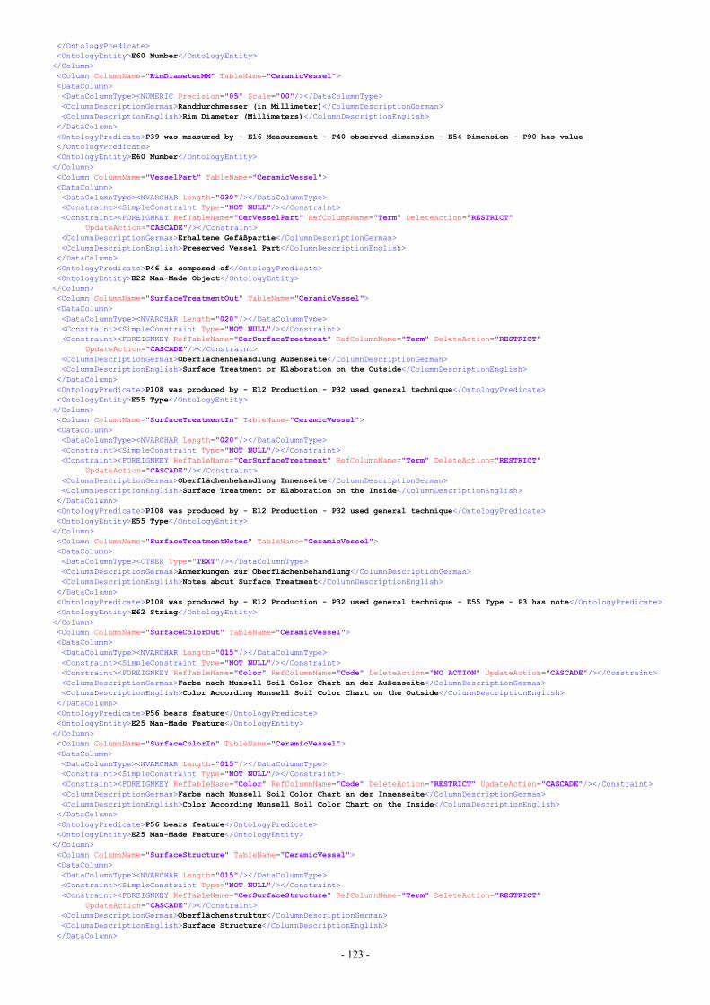
- 123 -
</OntologyPredicate><OntologyEntity>E60 Number</OntologyEntity></Column><Column ColumnName="RimDiameterMM" TableName="CeramicVessel"><DataColumn><DataColumnType><NUMERIC Precision="05" Scale="00"/></DataColumnType><ColumnDescriptionGerman>Randdurchmesser (in Millimeter)</ColumnDescriptionGerman><ColumnDescriptionEnglish>Rim Diameter (Millimeters)</ColumnDescriptionEnglish>
</DataColumn><OntologyPredicate>P39 was measured by - E16 Measurement - P40 observed dimension - E54 Dimension - P90 has value</OntologyPredicate><OntologyEntity>E60 Number</OntologyEntity></Column><Column ColumnName="VesselPart" TableName="CeramicVessel"><DataColumn><DataColumnType><NVARCHAR Length="030"/></DataColumnType><Constraint><SimpleConstraint Type="NOT NULL"/></Constraint><Constraint><FOREIGNKEY RefTableName="CerVesselPart" RefColumnName="Term" DeleteAction="RESTRICT"
UpdateAction="CASCADE"/></Constraint><ColumnDescriptionGerman>Erhaltene Gefäßpartie</ColumnDescriptionGerman><ColumnDescriptionEnglish>Preserved Vessel Part</ColumnDescriptionEnglish>
</DataColumn><OntologyPredicate>P46 is composed of</OntologyPredicate><OntologyEntity>E22 Man-Made Object</OntologyEntity></Column><Column ColumnName="SurfaceTreatmentOut" TableName="CeramicVessel"><DataColumn><DataColumnType><NVARCHAR Length="020"/></DataColumnType><Constraint><SimpleConstraint Type="NOT NULL"/></Constraint><Constraint><FOREIGNKEY RefTableName="CerSurfaceTreatment" RefColumnName="Term" DeleteAction="RESTRICT"
UpdateAction="CASCADE"/></Constraint><ColumnDescriptionGerman>Oberflächenhehandlung Außenseite</ColumnDescriptionGerman><ColumnDescriptionEnglish>Surface Treatment or Elaboration on the Outside</ColumnDescriptionEnglish>
</DataColumn><OntologyPredicate>P108 was produced by - E12 Production - P32 used general technique</OntologyPredicate><OntologyEntity>E55 Type</OntologyEntity></Column><Column ColumnName="SurfaceTreatmentIn" TableName="CeramicVessel"><DataColumn><DataColumnType><NVARCHAR Length="020"/></DataColumnType><Constraint><SimpleConstraint Type="NOT NULL"/></Constraint><Constraint><FOREIGNKEY RefTableName="CerSurfaceTreatment" RefColumnName="Term" DeleteAction="RESTRICT"
UpdateAction="CASCADE"/></Constraint><ColumnDescriptionGerman>Oberflächenhehandlung Innenseite</ColumnDescriptionGerman><ColumnDescriptionEnglish>Surface Treatment or Elaboration on the Inside</ColumnDescriptionEnglish>
</DataColumn><OntologyPredicate>P108 was produced by - E12 Production - P32 used general technique</OntologyPredicate><OntologyEntity>E55 Type</OntologyEntity></Column><Column ColumnName="SurfaceTreatmentNotes" TableName="CeramicVessel"><DataColumn><DataColumnType><OTHER Type="TEXT"/></DataColumnType><ColumnDescriptionGerman>Anmerkungen zur Oberflächenbehandlung</ColumnDescriptionGerman><ColumnDescriptionEnglish>Notes about Surface Treatment</ColumnDescriptionEnglish>
</DataColumn><OntologyPredicate>P108 was produced by - E12 Production - P32 used general technique - E55 Type - P3 has note</OntologyPredicate><OntologyEntity>E62 String</OntologyEntity></Column><Column ColumnName="SurfaceColorOut" TableName="CeramicVessel"><DataColumn><DataColumnType><NVARCHAR Length="015"/></DataColumnType><Constraint><SimpleConstraint Type="NOT NULL"/></Constraint><Constraint><FOREIGNKEY RefTableName="Color" RefColumnName="Code" DeleteAction="NO ACTION" UpdateAction="CASCADE"/></Constraint><ColumnDescriptionGerman>Farbe nach Munsell Soil Color Chart an der Außenseite</ColumnDescriptionGerman><ColumnDescriptionEnglish>Color According Munsell Soil Color Chart on the Outside</ColumnDescriptionEnglish>
</DataColumn><OntologyPredicate>P56 bears feature</OntologyPredicate><OntologyEntity>E25 Man-Made Feature</OntologyEntity></Column><Column ColumnName="SurfaceColorIn" TableName="CeramicVessel"><DataColumn><DataColumnType><NVARCHAR Length="015"/></DataColumnType><Constraint><SimpleConstraint Type="NOT NULL"/></Constraint><Constraint><FOREIGNKEY RefTableName="Color" RefColumnName="Code" DeleteAction="RESTRICT" UpdateAction="CASCADE"/></Constraint><ColumnDescriptionGerman>Farbe nach Munsell Soil Color Chart an der Innenseite</ColumnDescriptionGerman><ColumnDescriptionEnglish>Color According Munsell Soil Color Chart on the Inside</ColumnDescriptionEnglish>
</DataColumn><OntologyPredicate>P56 bears feature</OntologyPredicate><OntologyEntity>E25 Man-Made Feature</OntologyEntity></Column><Column ColumnName="SurfaceStructure" TableName="CeramicVessel"><DataColumn><DataColumnType><NVARCHAR Length="015"/></DataColumnType><Constraint><SimpleConstraint Type="NOT NULL"/></Constraint><Constraint><FOREIGNKEY RefTableName="CerSurfaceStructure" RefColumnName="Term" DeleteAction="RESTRICT"
UpdateAction="CASCADE"/></Constraint><ColumnDescriptionGerman>Oberflächenstruktur</ColumnDescriptionGerman><ColumnDescriptionEnglish>Surface Structure</ColumnDescriptionEnglish>
</DataColumn>
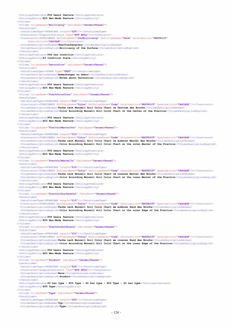
- 124 -
<OntologyPredicate>P56 bears feature</OntologyPredicate><OntologyEntity>E25 Man-Made Feature</OntologyEntity></Column><Column ColumnName="Brilliancy" TableName="CeramicVessel"><DataColumn><DataColumnType><NVARCHAR Length="025"/></DataColumnType><Constraint><SimpleConstraint Type="NOT NULL"/></Constraint><Constraint><FOREIGNKEY RefTableName="CerBrilliancy" RefColumnName="Term" DeleteAction="RESTRICT"
UpdateAction="CASCADE"/></Constraint><ColumnDescriptionGerman>Oberflächenglanz</ColumnDescriptionGerman><ColumnDescriptionEnglish>Brilliancy of the Surface</ColumnDescriptionEnglish>
</DataColumn><OntologyPredicate>P44 has condition</OntologyPredicate><OntologyEntity>E3 Condition State</OntologyEntity></Column><Column ColumnName="Decoration" TableName="CeramicVessel"><DataColumn><DataColumnType><OTHER Type="TEXT"/></DataColumnType><ColumnDescriptionGerman>Anmerkungen zu Dekor</ColumnDescriptionGerman><ColumnDescriptionEnglish>Notes about Decoration</ColumnDescriptionEnglish>
</DataColumn><OntologyPredicate>P56 bears feature</OntologyPredicate><OntologyEntity>E25 Man-Made Feature</OntologyEntity></Column><Column ColumnName="FractColorCore" TableName="CeramicVessel"><DataColumn><DataColumnType><NVARCHAR Length="015"/></DataColumnType><Constraint><FOREIGNKEY RefTableName="Color" RefColumnName="Code" DeleteAction="RESTRICT" UpdateAction="CASCADE"/></Constraint><ColumnDescriptionGerman>Farbe nach Munsell Soil Color Chart im Zentrum des Bruchs</ColumnDescriptionGerman><ColumnDescriptionEnglish>Color According Munsell Soil Color Chart on the Center of the Fraction</ColumnDescriptionEnglish>
</DataColumn><OntologyPredicate>P56 bears feature</OntologyPredicate><OntologyEntity>E25 Man-Made Feature</OntologyEntity></Column><Column ColumnName="FractColMantelOut" TableName="CeramicVessel"><DataColumn><DataColumnType><NVARCHAR Length="015"/></DataColumnType><Constraint><FOREIGNKEY RefTableName="Color" RefColumnName="Code" DeleteAction="RESTRICT" UpdateAction="CASCADE"/></Constraint><ColumnDescriptionGerman>Farbe nach Munsell Soil Color Chart im äußeren Mantel des Bruchs</ColumnDescriptionGerman><ColumnDescriptionEnglish>Color According Munsell Soil Color Chart on the outer Mantel of the Fraction</ColumnDescriptionEnglish>
</DataColumn><OntologyPredicate>P56 bears feature</OntologyPredicate><OntologyEntity>E25 Man-Made Feature</OntologyEntity></Column><Column ColumnName="FractColMantelIn" TableName="CeramicVessel"><DataColumn><DataColumnType><NVARCHAR Length="015"/></DataColumnType><Constraint><FOREIGNKEY RefTableName="Color" RefColumnName="Code" DeleteAction="RESTRICT" UpdateAction="CASCADE"/></Constraint><ColumnDescriptionGerman>Farbe nach Munsell Soil Color Chart im inneren Mantel des Bruchs</ColumnDescriptionGerman><ColumnDescriptionEnglish>Color According Munsell Soil Color Chart on the inner Mantel of the Fraction</ColumnDescriptionEnglish>
</DataColumn><OntologyPredicate>P56 bears feature</OntologyPredicate><OntologyEntity>E25 Man-Made Feature</OntologyEntity></Column><Column ColumnName="FractColSurfaceOut" TableName="CeramicVessel"><DataColumn><DataColumnType><NVARCHAR Length="015"/></DataColumnType><Constraint><FOREIGNKEY RefTableName="Color" RefColumnName="Code" DeleteAction="RESTRICT" UpdateAction="CASCADE"/></Constraint><ColumnDescriptionGerman>Farbe nach Munsell Soil Color Chart am äußeren Rand des Bruchs</ColumnDescriptionGerman><ColumnDescriptionEnglish>Color According Munsell Soil Color Chart on the outer Edge of the Fraction</ColumnDescriptionEnglish>
</DataColumn><OntologyPredicate>P56 bears feature</OntologyPredicate><OntologyEntity>E25 Man-Made Feature</OntologyEntity></Column><Column ColumnName="FractColSurfaceIn" TableName="CeramicVessel"><DataColumn><DataColumnType><NVARCHAR Length="015"/></DataColumnType><Constraint><FOREIGNKEY RefTableName="Color" RefColumnName="Code" DeleteAction="RESTRICT" UpdateAction="CASCADE"/></Constraint><ColumnDescriptionGerman>Farbe nach Munsell Soil Color Chart am inneren Rand des Bruchs</ColumnDescriptionGerman><ColumnDescriptionEnglish>Color According Munsell Soil Color Chart on the inner Edge of the Fraction</ColumnDescriptionEnglish>
</DataColumn><OntologyPredicate>P56 bears feature</OntologyPredicate><OntologyEntity>E25 Man-Made Feature</OntologyEntity></Column><Column ColumnName="Product" TableName="CeramicVessel"><DataColumn><DataColumnType><NVARCHAR Length="025"/></DataColumnType><Constraint><SimpleConstraint Type="NOT NULL"/></Constraint><ColumnDescriptionGerman>Ware</ColumnDescriptionGerman><ColumnDescriptionEnglish>Product</ColumnDescriptionEnglish>
</DataColumn><OntologyPredicate>P2 has type - E55 Type - P2 has type - E55 Type - P2 has type</OntologyPredicate><OntologyEntity>E55 Type</OntologyEntity></Column><Column ColumnName="Type" TableName="CeramicVessel"><DataColumn><DataColumnType><NVARCHAR Length="025"/></DataColumnType><ColumnDescriptionGerman>Typ</ColumnDescriptionGerman><ColumnDescriptionEnglish>Type</ColumnDescriptionEnglish>
- 125 -
</DataColumn><OntologyPredicate>P2 has type - E55 Type - P2 has type</OntologyPredicate><OntologyEntity>E55 Type</OntologyEntity></Column><Column ColumnName="Variant" TableName="CeramicVessel"><DataColumn><DataColumnType><NVARCHAR Length="025"/></DataColumnType><ColumnDescriptionGerman>Variante</ColumnDescriptionGerman><ColumnDescriptionEnglish>Variant</ColumnDescriptionEnglish>
</DataColumn><OntologyPredicate>P2 has type</OntologyPredicate><OntologyEntity>E55 Type</OntologyEntity></Column><TableDescriptionGerman>Keramikgefäße</TableDescriptionGerman><TableDescriptionEnglish>Ceramic Vessels</TableDescriptionEnglish><OntologyEntity>E22 Man-Made Object</OntologyEntity>
</Table>
<Table TableName="Coat" Use="Storage"><Column ColumnName="VesselID" TableName="Coat"><DataColumn><DataColumnType><NVARCHAR Length="030"/></DataColumnType><Constraint><SimpleConstraint Type="PRIMARY KEY"/></Constraint><Constraint><SimpleConstraint Type="NOT NULL"/></Constraint><Constraint><FOREIGNKEY RefTableName="CeramicVessel" RefColumnName="ID" DeleteAction="CASCADE"
UpdateAction="CASCADE"/></Constraint><ColumnDescriptionGerman>Fund ID</ColumnDescriptionGerman><ColumnDescriptionEnglish>ID of the Find</ColumnDescriptionEnglish>
</DataColumn><OntologyPredicate>P46 forms part of</OntologyPredicate><OntologyEntity>E22 Man-Made Object</OntologyEntity></Column><Column ColumnName="CoatID" TableName="Coat"><DataColumn><DataColumnType><NVARCHAR Length="020"/></DataColumnType><Constraint><SimpleConstraint Type="PRIMARY KEY"/></Constraint><Constraint><SimpleConstraint Type="NOT NULL"/></Constraint><ColumnDescriptionGerman>Überzug ID</ColumnDescriptionGerman><ColumnDescriptionEnglish>ID of the Coat</ColumnDescriptionEnglish>
</DataColumn><OntologyPredicate>P1 is identified by</OntologyPredicate><OntologyEntity>E42 Identifier</OntologyEntity></Column><Column ColumnName="Brilliancy" TableName="Coat"><DataColumn><DataColumnType><NVARCHAR Length="025"/></DataColumnType><Constraint><SimpleConstraint Type="NOT NULL"/></Constraint><Constraint><FOREIGNKEY RefTableName="CerBrilliancy" RefColumnName="Term" DeleteAction="RESTRICT"
UpdateAction="CASCADE"/></Constraint><ColumnDescriptionGerman>Oberflächenglanz</ColumnDescriptionGerman><ColumnDescriptionEnglish>Brilliancy of the Surface</ColumnDescriptionEnglish>
</DataColumn><OntologyPredicate>P1 is identified by</OntologyPredicate><OntologyEntity>E3 Composition State</OntologyEntity></Column><Column ColumnName="Decoration" TableName="Coat"><DataColumn><DataColumnType><OTHER Type="TEXT"/></DataColumnType><ColumnDescriptionGerman>Anmerkungen zu Dekor</ColumnDescriptionGerman><ColumnDescriptionEnglish>Notes about Decoration</ColumnDescriptionEnglish>
</DataColumn><OntologyPredicate>P56 bears feature</OntologyPredicate><OntologyEntity>E25 Man-Made Feature</OntologyEntity></Column><Column ColumnName="Extent" TableName="Coat"><DataColumn><DataColumnType><OTHER Type="TEXT"/></DataColumnType><ColumnDescriptionGerman>Lage und Ausdehnung des Überzugs</ColumnDescriptionGerman><ColumnDescriptionEnglish>Position and Extent of the Coat</ColumnDescriptionEnglish>
</DataColumn><OntologyPredicate>P39 was measured by</OntologyPredicate><OntologyEntity>E16 Measurement</OntologyEntity></Column><Column ColumnName="Color" TableName="Coat"><DataColumn><DataColumnType><NVARCHAR Length="015"/></DataColumnType><Constraint><FOREIGNKEY RefTableName="Color" RefColumnName="Code" DeleteAction="RESTRICT" UpdateAction="CASCADE"/></Constraint><ColumnDescriptionGerman>Farbe nach Munsell Soil Color Chart</ColumnDescriptionGerman><ColumnDescriptionEnglish>Color According Munsell Soil Color Chart</ColumnDescriptionEnglish>
</DataColumn><OntologyPredicate>P56 bears feature</OntologyPredicate><OntologyEntity>E25 Man-Made Feature</OntologyEntity></Column><TableDescriptionGerman>Überzug</TableDescriptionGerman><TableDescriptionEnglish>Coat</TableDescriptionEnglish><OntologyEntity>E22 Man-Made Object</OntologyEntity>
</Table></Database>
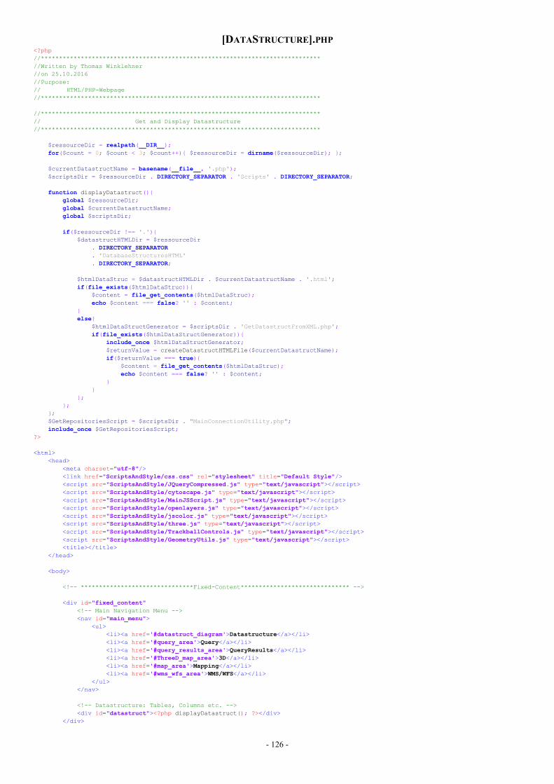
- 126 -
[DATASTRUCTURE].PHP<?php//*****************************************************************************//Written by Thomas Winklehner//on 25.10.2016//Purpose:// HTML/PHP-Webpage//*****************************************************************************
//*****************************************************************************// Get and Display Datastructure//*****************************************************************************
$ressourceDir = realpath(__DIR__);for($count = 0; $count < 3; $count++){ $ressourceDir = dirname($ressourceDir); };
$currentDatastructName = basename(__file__, '.php');$scriptsDir = $ressourceDir . DIRECTORY_SEPARATOR . 'Scripts' . DIRECTORY_SEPARATOR;
function displayDatastruct(){global $ressourceDir;global $currentDatastructName;global $scriptsDir;
if($ressourceDir !== '.'){$datastructHTMLDir = $ressourceDir
. DIRECTORY_SEPARATOR
. 'DatabaseStructuresHTML'
. DIRECTORY_SEPARATOR;
$htmlDataStruc = $datastructHTMLDir . $currentDatastructName . '.html';if(file_exists($htmlDataStruc)){
$content = file_get_contents($htmlDataStruc);echo $content === false? '' : $content;
}else{
$htmlDataStructGenerator = $scriptsDir . 'GetDatastructFromXML.php';if(file_exists($htmlDataStructGenerator)){
include_once $htmlDataStructGenerator;$returnValue = createDatastructHTMLFile($currentDatastructName);if($returnValue === true){
$content = file_get_contents($htmlDataStruc);echo $content === false? '' : $content;
}}
};};
};$GetRepositoriesScript = $scriptsDir . "MainConnectionUtility.php";include_once $GetRepositoriesScript;
?>
<html><head>
<meta charset="utf-8"/><link href="ScriptsAndStyle/css.css" rel="stylesheet" title="Default Style"/><script src="ScriptsAndStyle/JQueryCompressed.js" type="text/javascript"></script><script src="ScriptsAndStyle/cytoscape.js" type="text/javascript"></script><script src="ScriptsAndStyle/MainJSScript.js" type="text/javascript"></script><script src="ScriptsAndStyle/openlayers.js" type="text/javascript"></script><script src="ScriptsAndStyle/jscolor.js" type="text/javascript"></script><script src="ScriptsAndStyle/three.js" type="text/javascript"></script><script src="ScriptsAndStyle/TrackballControls.js" type="text/javascript"></script><script src="ScriptsAndStyle/GeometryUtils.js" type="text/javascript"></script><title></title>
</head>
<body>
<!-- *******************************Fixed-Content****************************** -->
<div id="fixed_content"<!-- Main Navigation Menu --><nav id="main_menu">
<ul><li><a href='#datastruct_diagram'>Datastructure</a></li><li><a href='#query_area'>Query</a></li><li><a href='#query_results_area'>QueryResults</a></li><li><a href='#ThreeD_map_area'>3D</a></li><li><a href='#map_area'>Mapping</a></li><li><a href='#wms_wfs_area'>WMS/WFS</a></li>
</ul></nav>
<!-- Datastructure: Tables, Columns etc. --><div id="datastruct"><?php displayDatastruct(); ?></div>
</div>
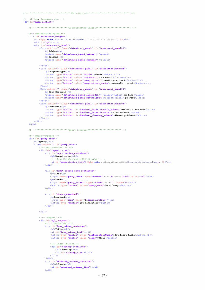
- 127 -
<!-- *******************************Main-Content******************************* -->
<!-- 2D Map, QueryArea etc. --><div id="main_content">
<!-- *************************Datastructure-Diagram************************* -->
<!-- Datastruct-Diagram --><div id="datastruct_diagram">
<h1><?php echo $currentDatastructName . ' - Structure Diagram'; ?></h1><div id="cy"></div><div id="datastruct_panel">
<form action="" class="datastruct_panel" id="datastruct_panel01"><p>Tables</p><select name="datastruct_panel_tables"></select><p>Columns</p><select name="datastruct_panel_columns"></select>
</form><form action="" class="datastruct_panel" id="datastruct_panel02">
<p>Diagram-Type</p><button type="button" value="circle">circle</button><br><button type="button" value="concentric">concentric</button><br><button type="button" value="breadthfirst">tree(single root)</button><br><button type="button" value="breadthfirst_roots">tree(mult. roots)</button><br>
</form><form action="" class="datastruct_panel" id="datastruct_panel03">
<p>Size-Controls</p><select name="datastruct_panel_linewidth"></select><label> px Line</label><select name="datastruct_panel_fontheight"></select><label> px Font</label>
</form><form action="" class="datastruct_panel" id="datastruct_panel04">
<p>Downloads</p><button type='button' id='download_datastructure_schema'>Datastruct-Schema</button><button type='button' id='download_datastructure'>Datastructure</button><button type='button' id='download_glossary_schema'>Glossary-Schema</button>
</form></div>
</div>
<!-- *************************Query-Composer************************* -->
<!-- Query-Composer --><div id="query_area">
<h1>Query</h1><form action="" id="query_form">
<!-- Repositorieslist --><div id="repositories">
<div id="repositories_container"><h2>Repositories</h2><!-- from MainConnectionUtility.php : --><ul id="repositories_list"><?php echo getRepositoriesHTML($currentDatastructName); ?></ul>
</div>
<div id="limit_offset_send_container"><p>limit</p><input name="query_limit" type='number' min='0' max='10000' value='100'/><br><p>offset</p><input name="query_offset" type='number' min='0' value='0'/><br><button type="button" value="query_send">Send Query</button>
</div>
<div id="binary_download"><p>Download</p><input type='text' value='Filename.suffix'/><br><button type="button">get Repository</button>
</div>
</div>
<!-- Composer --><div id="sql_composer">
<!-- From-Tables --><div id="from_tables_container">
<h2>Tables</h2><ul id="from_tables_list"></ul><button type="button" value="setFirstFromTable">Set First Table</button><br><button type="button" value="clear">Clear</button>
<!-- Order By List --><div id="orderBy_container">
<h2>Order by</h2><ul id="orderBy_list"></ul>
</div></div><div id="selected_columns_container">
<h2>Columns</h2><ul id="selected_columns_list"></ul>
</div>
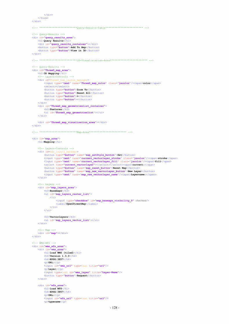
- 128 -
</div></form>
</div>
<!-- *************************Query-Results-Table************************* -->
<!-- Query-Results --><div id="query_results_area">
<h1>Query Results</h1><div id="query_results_container"></div><button type="button">Add To Map</button><button type="button">View in 3D</button>
</div>
<!-- *************************3D-Visualisiation-Area************************* -->
<!-- Query-Results --><div id="ThreeD_map_area">
<h1>3D Mapping</h1><!-- Layers-Controls --><div id=ThreeD_map_layers_manager>
<input type='text' name='ThreeD_map_color' class='jscolor'/><span>color</span><select></select><button type="button">Zoom To</button><button type="button">Reset All</button><button type="button">></button><button type="button"><</button>
</div><div id="ThreeD_map_geometrieslist_container">
<h3>Features</h3><ul id='ThreeD_map_geometrieslist'></ul>
</div>
<div id="ThreeD_map_visualisation_area"></div></div>
<!-- *************************Map-Area************************* -->
<div id="map_area"><h1>Mapping</h1>
<!-- Layers-Controls --><div id=map_layers_manager>
<button type="button" name='map_setStyle_button'>Set</button><input type='text' name='current_vectorlayer_stroke' class='jscolor'/><span>stroke</span><input type='text' name='current_vectorlayer_fill' class='jscolor'/><span>fill</span><select name="current_vectorlayer"></select></select><span>current:</span><button type="button" name='map_reset_button'>Reset Map</button><button type="button" name='map_new_vectorlayer_button'>New Layer</button><input type='text' name='map_new_vectorlayer_name'/><span>Layername:</span>
</div>
<!-- Layers --><div id="map_layers_area">
<h3>Basemaps</h3><ul id='map_layers_raster_list'>
<li><input type="checkbox" id="map_basmaps_visibility_0" checked/><label>OpenStreetMap</label>
</li></ul>
<h3>Vectorlayers</h3><ul id='map_layers_vector_list'></ul>
</div>
<!-- Map --><div id="map"></div>
</div>
<!-- WMS-WFS --><div id="wms_wfs_area">
<div id="wms_area"><h1>load WMS (tiled)</h1><h4>Version 1.3.0</h4><h4>EPSG:3857</h4><p>URL:</p><input id="wms_url" type=text title="url"/><p>Layer:</p><input type=text id="wms_layer" title="Layer-Name"/><button type='button'>Request</button>
</div>
<div id="wfs_area"><h1>load WFS</h1><h4>EPSG:3857</h4><p>URL:</p><input id="wfs_url" type=text title="url"/><p>typename</p>

- 129 -
<input type=text id="wfs_layer" title="Layer-Name"/><p>output-format</p><select>
<option value='json'>json</option><option value='application/json'>application/json</option><option value='gml'>gml</option><option value='GML'>GML</option><option value='gml3'>gml3</option><option value='GML3'>GML3</option><option value='kml'>kml</option><option value='KML'>KML</option>
</select><br/><button type='button'>Request</button>
</div></div>
</div>
</body></html>
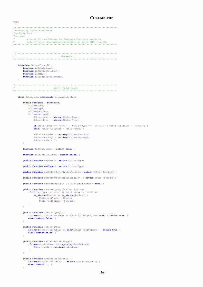
- 130 -
COLUMN.PHP<?php
//*****************************************************************************//Written by Thomas Winklehner//on 22.10.2016//Purpose:// - provide Columns-Classes for Database-Structure emulation// - helping outputting Database-Structure as valid HTML from XML//*****************************************************************************
//*****************************************************************************// INTERFACE//*****************************************************************************
interface ColumnsInterface{function isDataColumn();function isSpatialColumn();function ToHTML();function setTable($TableName);
}
//*****************************************************************************// BASIC COLUMN CLASS//*****************************************************************************
class DataColumn implements ColumnsInterface{
public function __construct($ColumnName,$ColumnType,$ColumnDescGerm,$ColumnDescEngl){
$this->Name = (string)$ColumnName;$this->Type = (string)$ColumnType;
if($this->Type === 'REAL' || $this->Type === 'INTEGER'){ $this->Category = 'NUMBER'; }else{ $this->Category = $this->Type; }
$this->DescGerm = (string)$ColumnDescGerm;$this->DescEngl = (string)$ColumnDescEngl;$this->table = "";
}
function isDataColumn(){ return true; }
function isSpatialColumn(){ return false; }
public function getName(){ return $this->Name; }
public function getType(){ return $this->Type; }
public function getColumnDescriptionGerman(){ return $this->DescGerm; }
public function getColumnDescriptionEnglish(){ return $this->DescEngl; }
public function setPrimaryKey() { $this->primaryKey = true; }
public function setForeignKey($table, $column) {if($this->Type != "BLOB" && $this->Type != "TEXT" &&
is_string($table) && is_string($column)){$this->refTable = $table;$this->refColumn = $column;
}}
public function isPrimaryKey() {if(isset($this->primaryKey) && $this->primaryKey === true) { return true; }else{ return false; }
}
public function isForeignKey() {if(isset($this->refTable) && isset($this->refColumn)) { return true; }else{ return false; }
}
public function setTable($tableName){if(isset($tableName) && is_string($tableName)){
$this->table = (string)$tableName;};
}
public function getForeignKeyTable() {if(isset($this->refTable)) { return $this->refTable; }else{ return ""; }
}
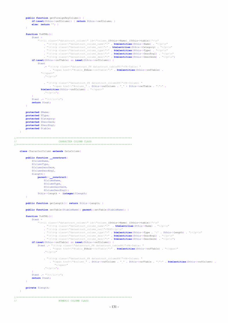
- 131 -
public function getForeignKeyColumn() {if(isset($this->refColumn)) { return $this->refColumn; }else{ return ""; }
}
function ToHTML(){$text =
"\t<li class=\"datastruct_column\" id=\"column_{$this->Name}_{$this->table}\">\n". "\t\t<p class=\"datastruct_column_name\">" . htmlentities($this->Name) . "</p>\n". "\t\t<p class=\"datastruct_column_cat\">" . htmlentities($this->Category) . "</p>\n". "\t\t<p class=\"datastruct_column_type\">" . htmlentities($this->Type) . "</p>\n". "\t\t<p class=\"datastruct_column_desc\">" . htmlentities($this->DescEngl) . "</p>\n". "\t\t<p class=\"datastruct_column_desc\">" . htmlentities($this->DescGerm) . "</p>\n";
if(isset($this->refTable) && isset($this->refColumn)) {$text
.= "\t\t<p class=\"datastruct_FK datastruct_tableFK\">FK-Table: ". "<span href=\"#table_$this->refTable\">" . htmlentities($this->refTable) .
"</span>"."</p>\n"
. "\t\t<p class=\"datastruct_FK datastruct_columnFK\">FK-Column: ". "<span href=\"#column_" . $this->refColumn . "_" + $this->refTable . "\">" .
htmlentities($this->refColumn) . "</span>"."</p>\n";
}$text .= "\t</li>\n";return $text;
}
protected $Name;protected $Type;protected $Category;protected $DescGerm;protected $DescEngl;protected $table;
}
//*****************************************************************************// CHARACTER COLUMN CLASS//*****************************************************************************
class CharacterColumn extends DataColumn{
public function __construct($ColumnName,$ColumnType,$ColumnDescGerm,$ColumnDescEngl,$length){
parent::__construct($ColumnName,$ColumnType,$ColumnDescGerm,$ColumnDescEngl);
$this->length = (integer)$length;}
public function getLength(){ return $this->length; }
public function setTable($tableName){ parent::setTable($tableName); }
function ToHTML(){$text =
"\t<li class=\"datastruct_column\" id=\"column_{$this->Name}_{$this->table}\">\n". "\t\t<p class=\"datastruct_column_name\">" . htmlentities($this->Name) . "</p>\n". "\t\t<p class=\"datastruct_column_cat\">TEXT</p>\n". "\t\t<p class=\"datastruct_column_type\">" . htmlentities($this->Type . '(' . $this->length) . ")</p>\n". "\t\t<p class=\"datastruct_column_desc\">" . htmlentities($this->DescEngl) . "</p>\n". "\t\t<p class=\"datastruct_column_desc\">" . htmlentities($this->DescGerm) . "</p>\n";
if(isset($this->refTable) && isset($this->refColumn)) {$text .= "\t\t<p class=\"datastruct_FK datastruct_tableFK\">FK-Table: "
. "<span href=\"#table_$this->refTable\">" . htmlentities($this->refTable) . "</span>"."</p>\n"
. "\t\t<p class=\"datastruct_FK datastruct_columnFK\">FK-Column: ". "<span href=\"#column_" . $this->refColumn . "_" . $this->refTable . "\">" . htmlentities($this->refColumn) .
"</span>"."</p>\n";
}$text .= "\t</li>\n";return $text;
}
private $length;}
//*****************************************************************************// NUMERIC COLUMN CLASS
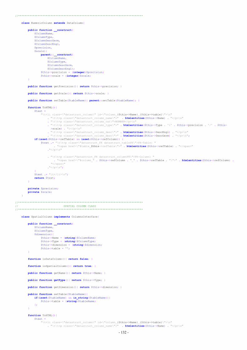
- 132 -
//*****************************************************************************
class NumericColumn extends DataColumn{
public function __construct($ColumnName,$ColumnType,$ColumnDescGerm,$ColumnDescEngl,$precision,$scale){
parent::__construct($ColumnName,$ColumnType,$ColumnDescGerm,$ColumnDescEngl);
$this->precision = (integer)$precision;$this->scale = (integer)$scale;
}
public function getPrecision(){ return $this->precision; }
public function getScale(){ return $this->scale; }
public function setTable($tableName){ parent::setTable($tableName); }
function ToHTML(){$text =
"\t<li class=\"datastruct_column\" id=\"column_{$this->Name}_{$this->table}\">\n". "\t\t<p class=\"datastruct_column_name\">" . htmlentities($this->Name) . "</p>\n". "\t\t<p class=\"datastruct_column_cat\">NUMBER</p>\n". "\t\t<p class=\"datastruct_column_type\">" . htmlentities($this->Type . '(' . $this->precision . '/' . $this-
>scale) . ")</p>\n". "\t\t<p class=\"datastruct_column_desc\">" . htmlentities($this->DescEngl) . "</p>\n". "\t\t<p class=\"datastruct_column_desc\">" . htmlentities($this->DescGerm) . "</p>\n";
if(isset($this->refTable) && isset($this->refColumn)) {$text .= "\t\t<p class=\"datastruct_FK datastruct_tableFK\">FK-Table: "
. "<span href=\"#table_$this->refTable\">" . htmlentities($this->refTable) . "</span>"."</p>\n"
. "\t\t<p class=\"datastruct_FK datastruct_columnFK\">FK-Column: ". "<span href=\"#column_" . $this->refColumn . "_" . $this->refTable . "\">" . htmlentities($this->refColumn) .
"</span>"."</p>\n";
}$text .= "\t</li>\n";return $text;
}
private $precision;private $scale;
}
//*****************************************************************************// SPATIAL COLUMN CLASS//*****************************************************************************
class SpatialColumn implements ColumnsInterface{
public function __construct($ColumnName,$ColumnType,$dimension){
$this->Name = (string)$ColumnName;$this->Type = (string)$ColumnType;$this->dimension = (string)$dimension;$this->table = "";
}
function isDataColumn(){ return false; }
function isSpatialColumn(){ return true; }
public function getName(){ return $this->Name; }
public function getType(){ return $this->Type; }
public function getDimension(){ return $this->dimension; }
public function setTable($tableName){if(isset($tableName) && is_string($tableName)){
$this->table = (string)$tableName;};
}
function ToHTML(){$text =
"\t<li class=\"datastruct_column\" id=\"column_{$this->Name}_{$this->table}\">\n". "\t\t<p class=\"datastruct_column_name\">" . htmlentities($this->Name) . "</p>\n"

- 133 -
. "\t\t<p class=\"datastruct_column_cat\">GEOMETRY</p>\n"
. "\t\t<p class=\"datastruct_column_type\">" . htmlentities($this->Type) . "</p>\n"
. "\t\t<p class=\"datastruct_column_dimension\">" . htmlentities($this->dimension) . "</p>\n". "\t</li>\n";
return $text;}
private $Name;private $Type;private $dimension;private $table;
}
?>
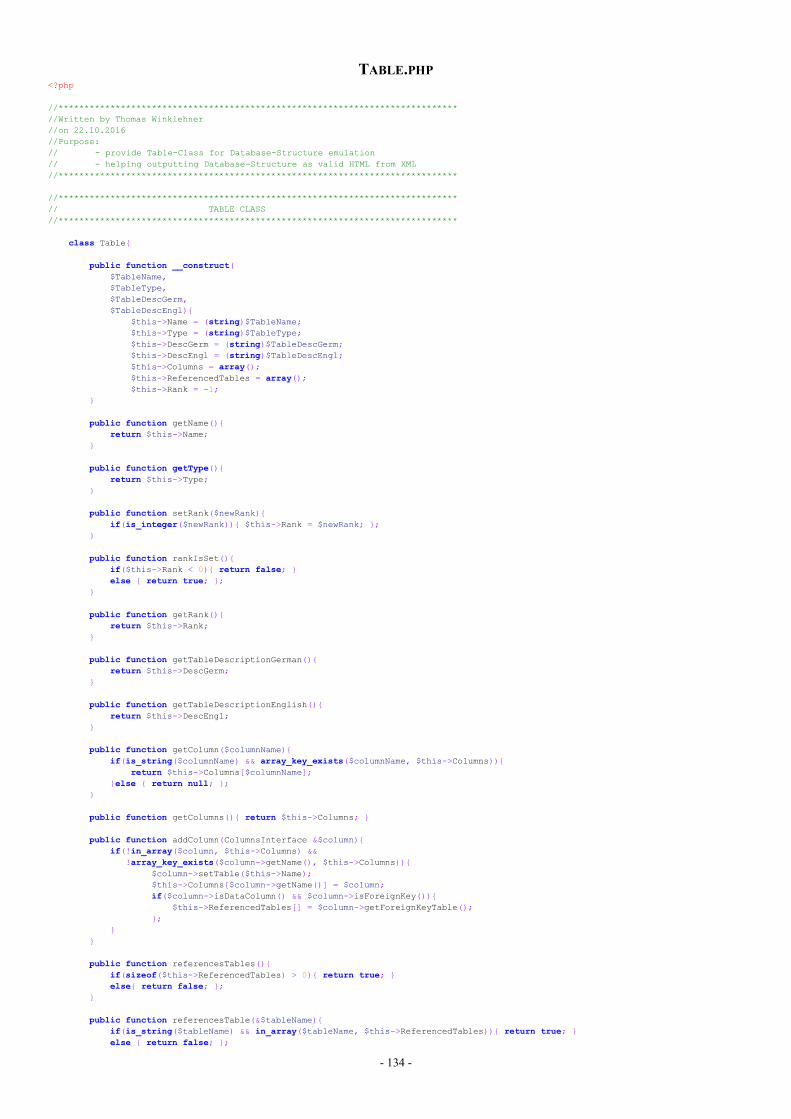
- 134 -
TABLE.PHP<?php
//*****************************************************************************//Written by Thomas Winklehner//on 22.10.2016//Purpose:// - provide Table-Class for Database-Structure emulation// - helping outputting Database-Structure as valid HTML from XML//*****************************************************************************
//*****************************************************************************// TABLE CLASS//*****************************************************************************
class Table{
public function __construct($TableName,$TableType,$TableDescGerm,$TableDescEngl){
$this->Name = (string)$TableName;$this->Type = (string)$TableType;$this->DescGerm = (string)$TableDescGerm;$this->DescEngl = (string)$TableDescEngl;$this->Columns = array();$this->ReferencedTables = array();$this->Rank = -1;
}
public function getName(){return $this->Name;
}
public function getType(){return $this->Type;
}
public function setRank($newRank){if(is_integer($newRank)){ $this->Rank = $newRank; };
}
public function rankIsSet(){if($this->Rank < 0){ return false; }else { return true; };
}
public function getRank(){return $this->Rank;
}
public function getTableDescriptionGerman(){return $this->DescGerm;
}
public function getTableDescriptionEnglish(){return $this->DescEngl;
}
public function getColumn($columnName){if(is_string($columnName) && array_key_exists($columnName, $this->Columns)){
return $this->Columns[$columnName];}else { return null; };
}
public function getColumns(){ return $this->Columns; }
public function addColumn(ColumnsInterface &$column){if(!in_array($column, $this->Columns) &&
!array_key_exists($column->getName(), $this->Columns)){$column->setTable($this->Name);$this->Columns[$column->getName()] = $column;if($column->isDataColumn() && $column->isForeignKey()){
$this->ReferencedTables[] = $column->getForeignKeyTable();};
}}
public function referencesTables(){if(sizeof($this->ReferencedTables) > 0){ return true; }else{ return false; };
}
public function referencesTable(&$tableName){if(is_string($tableName) && in_array($tableName, $this->ReferencedTables)){ return true; }else { return false; };
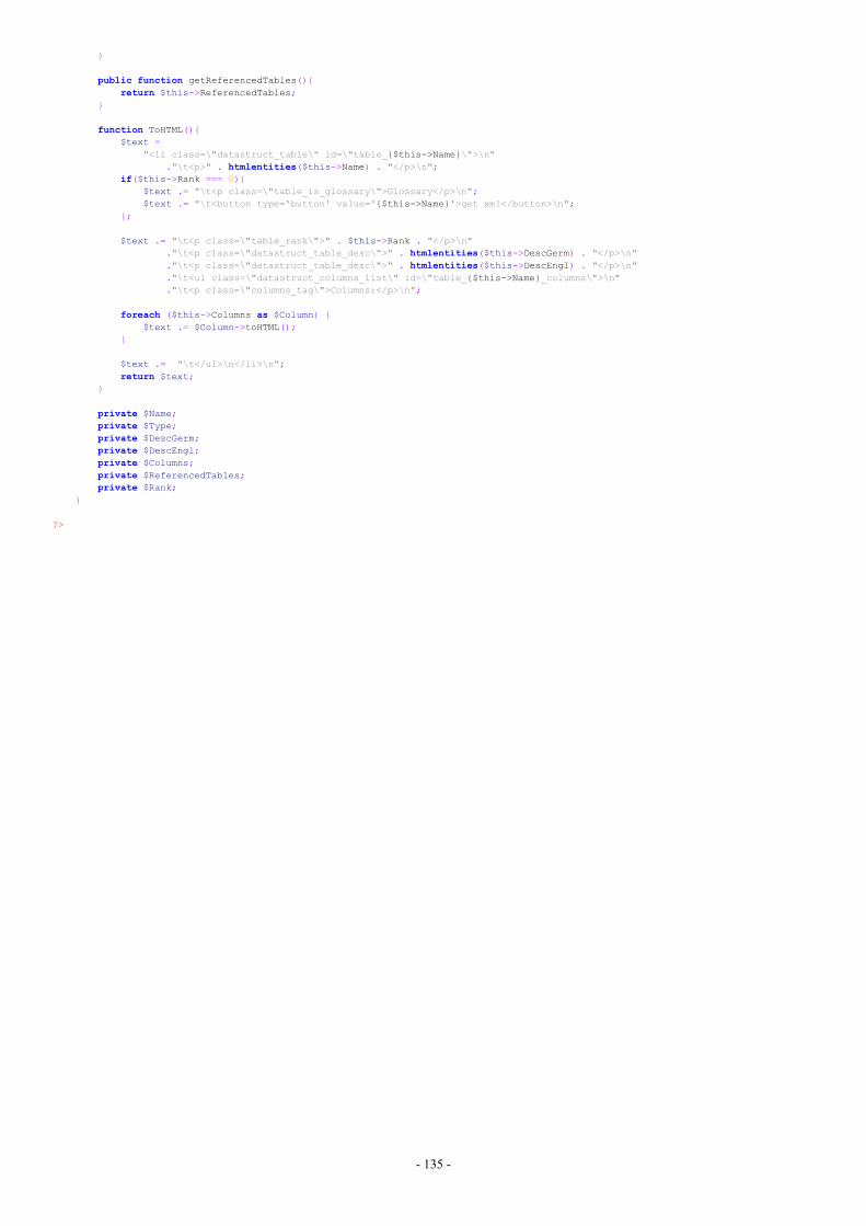
- 135 -
}
public function getReferencedTables(){return $this->ReferencedTables;
}
function ToHTML(){$text =
"<li class=\"datastruct_table\" id=\"table_{$this->Name}\">\n"."\t<p>" . htmlentities($this->Name) . "</p>\n";
if($this->Rank === 0){$text .= "\t<p class=\"table_is_glossary\">Glossary</p>\n";$text .= "\t<button type='button' value='{$this->Name}'>get xml</button>\n";
};
$text .= "\t<p class=\"table_rank\">" . $this->Rank . "</p>\n"."\t<p class=\"datastruct_table_desc\">" . htmlentities($this->DescGerm) . "</p>\n"."\t<p class=\"datastruct_table_desc\">" . htmlentities($this->DescEngl) . "</p>\n"."\t<ul class=\"datastruct_columns_list\" id=\"table_{$this->Name}_columns\">\n"."\t<p class=\"columns_tag\">Columns:</p>\n";
foreach ($this->Columns as $Column) {$text .= $Column->toHTML();
}
$text .= "\t</ul>\n</li>\n";return $text;
}
private $Name;private $Type;private $DescGerm;private $DescEngl;private $Columns;private $ReferencedTables;private $Rank;
}
?>
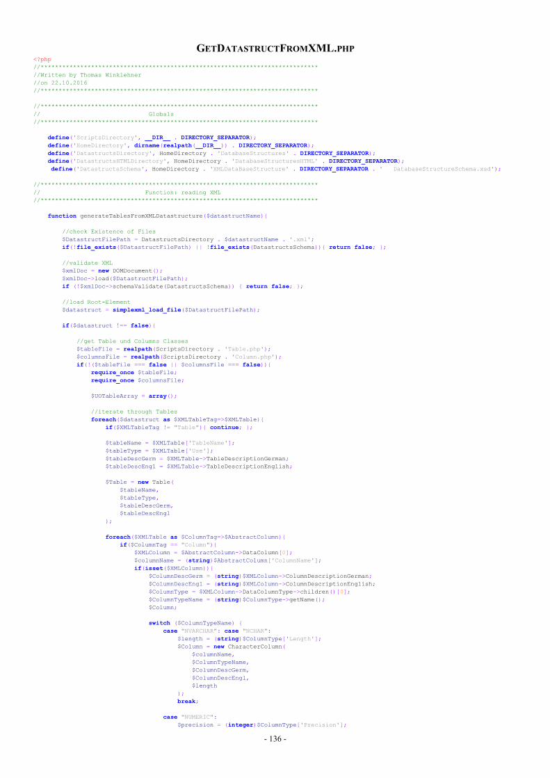
- 136 -
GETDATASTRUCTFROMXML.PHP<?php//*****************************************************************************//Written by Thomas Winklehner//on 22.10.2016//*****************************************************************************
//*****************************************************************************// Globals//*****************************************************************************
define('ScriptsDirectory', __DIR__ . DIRECTORY_SEPARATOR);define('HomeDirectory', dirname(realpath(__DIR__)) . DIRECTORY_SEPARATOR);define('DatastructsDirectory', HomeDirectory . 'DatabaseStructures' . DIRECTORY_SEPARATOR);define('DatastructsHTMLDirectory', HomeDirectory . 'DatabaseStructuresHTML' . DIRECTORY_SEPARATOR);define('DatastructsSchema', HomeDirectory . 'XMLDataBaseStructure' . DIRECTORY_SEPARATOR . ' DatabaseStructureSchema.xsd');
//*****************************************************************************// Function: reading XML//*****************************************************************************
function generateTablesFromXMLDatastructure($datastructName){
//check Existence of Files$DatastructFilePath = DatastructsDirectory . $datastructName . '.xml';if(!file_exists($DatastructFilePath) || !file_exists(DatastructsSchema)){ return false; };
//validate XML$xmlDoc = new DOMDocument();$xmlDoc->load($DatastructFilePath);if (!$xmlDoc->schemaValidate(DatastructsSchema)) { return false; };
//load Root-Element$datastruct = simplexml_load_file($DatastructFilePath);
if($datastruct !== false){
//get Table und Columns Classes$tableFile = realpath(ScriptsDirectory . 'Table.php');$columnsFile = realpath(ScriptsDirectory . 'Column.php');if(!($tableFile === false || $columnsFile === false)){
require_once $tableFile;require_once $columnsFile;
$UOTableArray = array();
//iterate through Tablesforeach($datastruct as $XMLTableTag=>$XMLTable){
if($XMLTableTag != "Table"){ continue; };
$tableName = $XMLTable['TableName'];$tableType = $XMLTable['Use'];$tableDescGerm = $XMLTable->TableDescriptionGerman;$tableDescEngl = $XMLTable->TableDescriptionEnglish;
$Table = new Table($tableName,$tableType,$tableDescGerm,$tableDescEngl
);
foreach($XMLTable as $ColumnTag=>$AbstractColumn){if($ColumnTag == "Column"){
$XMLColumn = $AbstractColumn->DataColumn[0];$columnName = (string)$AbstractColumn['ColumnName'];if(isset($XMLColumn)){
$ColumnDescGerm = (string)$XMLColumn->ColumnDescriptionGerman;$ColumnDescEngl = (string)$XMLColumn->ColumnDescriptionEnglish;$ColumnType = $XMLColumn->DataColumnType->children()[0];$ColumnTypeName = (string)$ColumnType->getName();$Column;
switch ($ColumnTypeName) {case "NVARCHAR": case "NCHAR":
$length = (string)$ColumnType['Length'];$Column = new CharacterColumn(
$columnName,$ColumnTypeName,$ColumnDescGerm,$ColumnDescEngl,$length
);break;
case "NUMERIC":$precision = (integer)$ColumnType['Precision'];
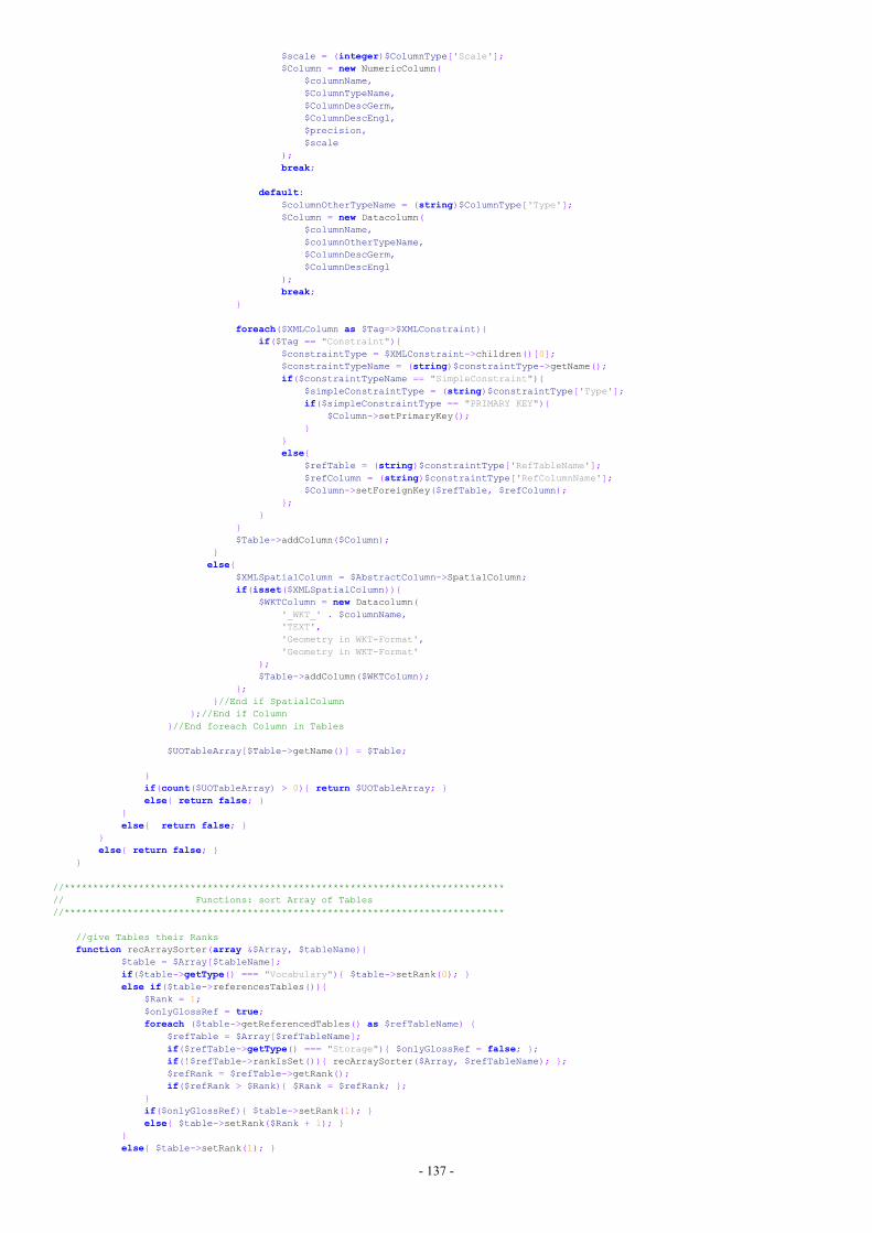
- 137 -
$scale = (integer)$ColumnType['Scale'];$Column = new NumericColumn(
$columnName,$ColumnTypeName,$ColumnDescGerm,$ColumnDescEngl,$precision,$scale
);break;
default:$columnOtherTypeName = (string)$ColumnType['Type'];$Column = new Datacolumn(
$columnName,$columnOtherTypeName,$ColumnDescGerm,$ColumnDescEngl
);break;
}
foreach($XMLColumn as $Tag=>$XMLConstraint){if($Tag == "Constraint"){
$constraintType = $XMLConstraint->children()[0];$constraintTypeName = (string)$constraintType->getName();if($constraintTypeName == "SimpleConstraint"){
$simpleConstraintType = (string)$constraintType['Type'];if($simpleConstraintType == "PRIMARY KEY"){
$Column->setPrimaryKey();}
}else{
$refTable = (string)$constraintType['RefTableName'];$refColumn = (string)$constraintType['RefColumnName'];$Column->setForeignKey($refTable, $refColumn);
};}
}$Table->addColumn($Column);
}else{
$XMLSpatialColumn = $AbstractColumn->SpatialColumn;if(isset($XMLSpatialColumn)){
$WKTColumn = new Datacolumn('_WKT_' . $columnName,'TEXT','Geometry in WKT-Format','Geometry in WKT-Format'
);$Table->addColumn($WKTColumn);
};}//End if SpatialColumn
};//End if Column}//End foreach Column in Tables
$UOTableArray[$Table->getName()] = $Table;
}if(count($UOTableArray) > 0){ return $UOTableArray; }else{ return false; }
}else{ return false; }
}else{ return false; }
}
//*****************************************************************************// Functions: sort Array of Tables//*****************************************************************************
//give Tables their Ranksfunction recArraySorter(array &$Array, $tableName){
$table = $Array[$tableName];if($table->getType() === "Vocabulary"){ $table->setRank(0); }else if($table->referencesTables()){
$Rank = 1;$onlyGlossRef = true;foreach ($table->getReferencedTables() as $refTableName) {
$refTable = $Array[$refTableName];if($refTable->getType() === "Storage"){ $onlyGlossRef = false; };if(!$refTable->rankIsSet()){ recArraySorter($Array, $refTableName); };$refRank = $refTable->getRank();if($refRank > $Rank){ $Rank = $refRank; };
}if($onlyGlossRef){ $table->setRank(1); }else{ $table->setRank($Rank + 1); }
}else{ $table->setRank(1); }
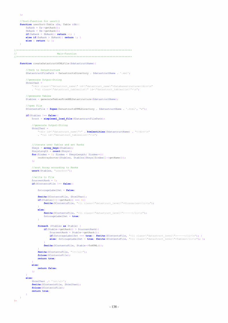
- 138 -
};
//Sort-Function for usort()function userSort(Table &$a, Table &$b){
$aRank = $a->getRank();$bRank = $b->getRank();if($aRank < $bRank){ return -1; }else if($aRank > $bRank){ return 1; }else { return 0; };
}
//*****************************************************************************// Main-Function//*****************************************************************************
function createDatastructHTMLFile($datastructName){
//Path to Datastructure$DatastructFilePath = DatastructsDirectory . $datastructName . '.xml';
//generate Output-String$htmlText =
"<div class=\"datastruct_name\" id=\"datastruct_name\">Databasestructure</div>\n". "<ul class=\"datastruct_tableslist\" id=\"datastruct_tableslist\">\n";
//generate Tables$tables = generateTablesFromXMLDatastructure($datastructName);
//open File$ContentsFile = fopen(DatastructsHTMLDirectory . $datastructName . '.html', "w");
if($tables !== false){$root = simplexml_load_file($DatastructFilePath);
//generate Output-String$htmlText =
"<div id=\"datastruct_name\">" . htmlentities($datastructName) . "</div>\n". "<ul id=\"datastruct_tableslist\">\n";
//iterate over Tables and set Ranks$keys = array_keys($tables);$keysLength = count($keys);for($index = 0; $index < $keysLength; $index++){
recArraySorter($tables, $tables[$keys[$index]]->getName());};
//sort Array according to Ranksusort($tables, "userSort");
//write to File$currentRank = 0;if($ContentsFile !== false){
$storageLabelSet = false;
fwrite($ContentsFile, $htmlText);if($tables[0]->getRank() === 0){
fwrite($ContentsFile, "<li class=\"datastruct_level\">Glossaries</li>\n");}else{
fwrite($ContentsFile, "<li class=\"datastruct_level\">-----</li>\n");$storageLabelSet = true;
}
foreach ($tables as $table) {if($table->getRank() > $currentRank){
$currentRank = $table->getRank();if($storageLabelSet === true){ fwrite($ContentsFile, "<li class=\"datastruct_level\">-----</li>\n"); }else{ $storageLabelSet = true; fwrite($ContentsFile, "<li class=\"datastruct_level\">Tables</li>\n"); };
}fwrite($ContentsFile, $table->ToHTML());
}fwrite($ContentsFile, "\t</ul>");fclose($ContentsFile);return true;
}else{
return false;};
}else{
$htmlText .= '\n</ul>';fwrite($ContentsFile, $htmlText);fclose($ContentsFile);return true;
}}
?>
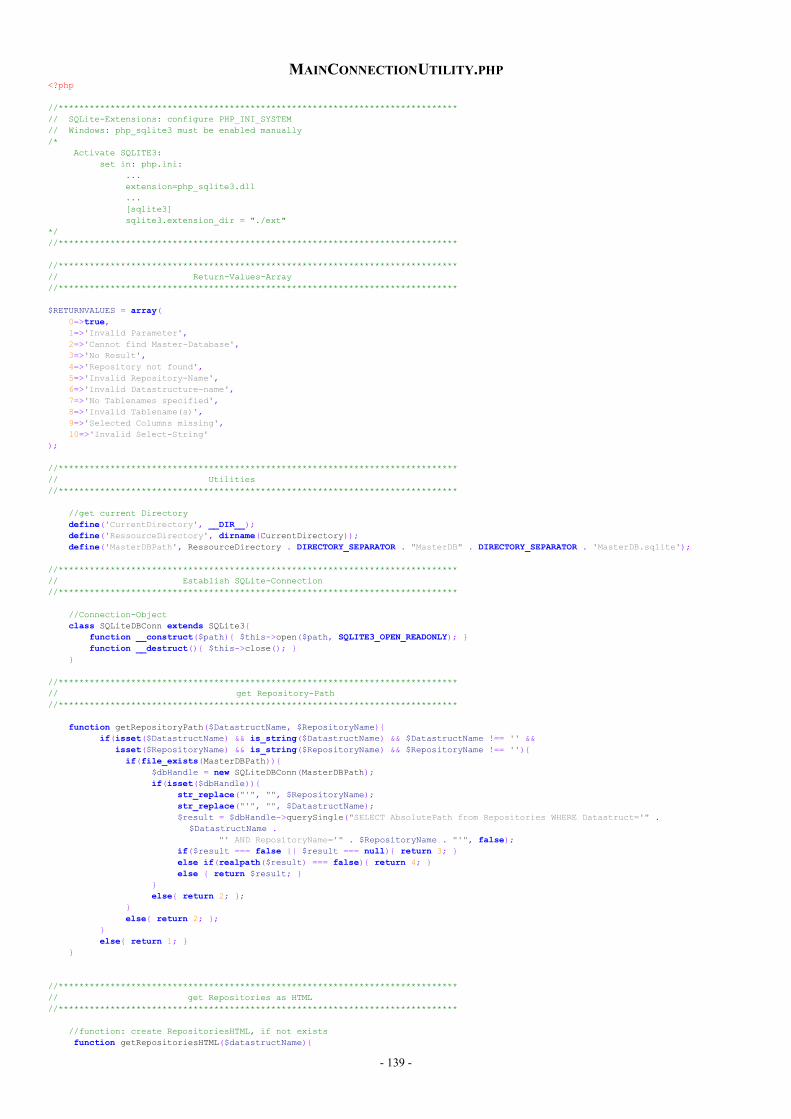
- 139 -
MAINCONNECTIONUTILITY.PHP<?php
//*****************************************************************************// SQLite-Extensions: configure PHP_INI_SYSTEM// Windows: php_sqlite3 must be enabled manually/*
Activate SQLITE3:set in: php.ini:
...extension=php_sqlite3.dll...[sqlite3]sqlite3.extension_dir = "./ext"
*///*****************************************************************************
//*****************************************************************************// Return-Values-Array//*****************************************************************************
$RETURNVALUES = array(0=>true,1=>'Invalid Parameter',2=>'Cannot find Master-Database',3=>'No Result',4=>'Repository not found',5=>'Invalid Repository-Name',6=>'Invalid Datastructure-name',7=>'No Tablenames specified',8=>'Invalid Tablename(s)',9=>'Selected Columns missing',10=>'Invalid Select-String'
);
//*****************************************************************************// Utilities//*****************************************************************************
//get current Directorydefine('CurrentDirectory', __DIR__);define('RessourceDirectory', dirname(CurrentDirectory));define('MasterDBPath', RessourceDirectory . DIRECTORY_SEPARATOR . "MasterDB" . DIRECTORY_SEPARATOR . 'MasterDB.sqlite');
//*****************************************************************************// Establish SQLite-Connection//*****************************************************************************
//Connection-Objectclass SQLiteDBConn extends SQLite3{
function __construct($path){ $this->open($path, SQLITE3_OPEN_READONLY); }function __destruct(){ $this->close(); }
}
//*****************************************************************************// get Repository-Path//*****************************************************************************
function getRepositoryPath($DatastructName, $RepositoryName){if(isset($DatastructName) && is_string($DatastructName) && $DatastructName !== '' &&
isset($RepositoryName) && is_string($RepositoryName) && $RepositoryName !== ''){if(file_exists(MasterDBPath)){
$dbHandle = new SQLiteDBConn(MasterDBPath);if(isset($dbHandle)){
str_replace("'", "", $RepositoryName);str_replace("'", "", $DatastructName);$result = $dbHandle->querySingle("SELECT AbsolutePath from Repositories WHERE Datastruct='" .
$DatastructName ."' AND RepositoryName='" . $RepositoryName . "'", false);
if($result === false || $result === null){ return 3; }else if(realpath($result) === false){ return 4; }else { return $result; }
}else{ return 2; };
}else{ return 2; };
}else{ return 1; }
}
//*****************************************************************************// get Repositories as HTML//*****************************************************************************
//function: create RepositoriesHTML, if not existsfunction getRepositoriesHTML($datastructName){
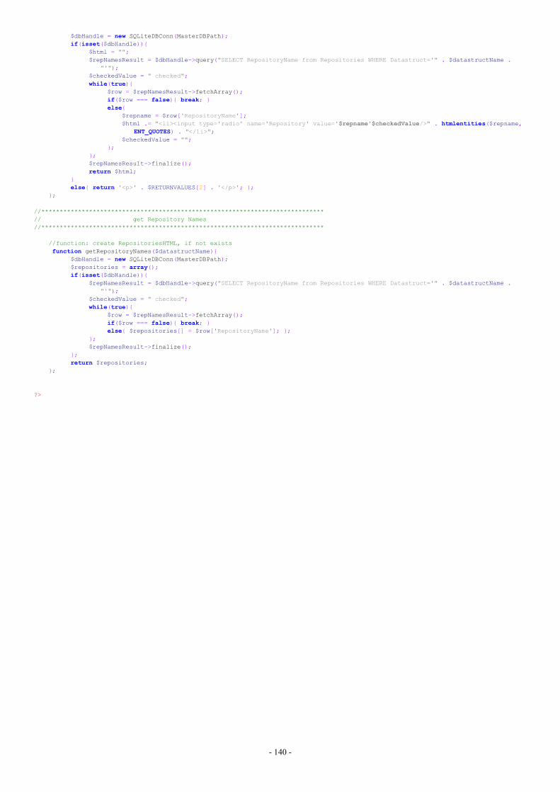
- 140 -
$dbHandle = new SQLiteDBConn(MasterDBPath);if(isset($dbHandle)){
$html = "";$repNamesResult = $dbHandle->query("SELECT RepositoryName from Repositories WHERE Datastruct='" . $datastructName .
"'");$checkedValue = " checked";while(true){
$row = $repNamesResult->fetchArray();if($row === false){ break; }else{
$repname = $row['RepositoryName'];$html .= "<li><input type='radio' name='Repository' value='$repname'$checkedValue/>" . htmlentities($repname,
ENT_QUOTES) . "</li>";$checkedValue = "";
};};$repNamesResult->finalize();return $html;
}else{ return '<p>' . $RETURNVALUES[2] . '</p>'; };
};
//*****************************************************************************// get Repository Names//*****************************************************************************
//function: create RepositoriesHTML, if not existsfunction getRepositoryNames($datastructName){
$dbHandle = new SQLiteDBConn(MasterDBPath);$repositories = array();if(isset($dbHandle)){
$repNamesResult = $dbHandle->query("SELECT RepositoryName from Repositories WHERE Datastruct='" . $datastructName ."'");
$checkedValue = " checked";while(true){
$row = $repNamesResult->fetchArray();if($row === false){ break; }else{ $repositories[] = $row['RepositoryName']; };
};$repNamesResult->finalize();
};return $repositories;
};
?>
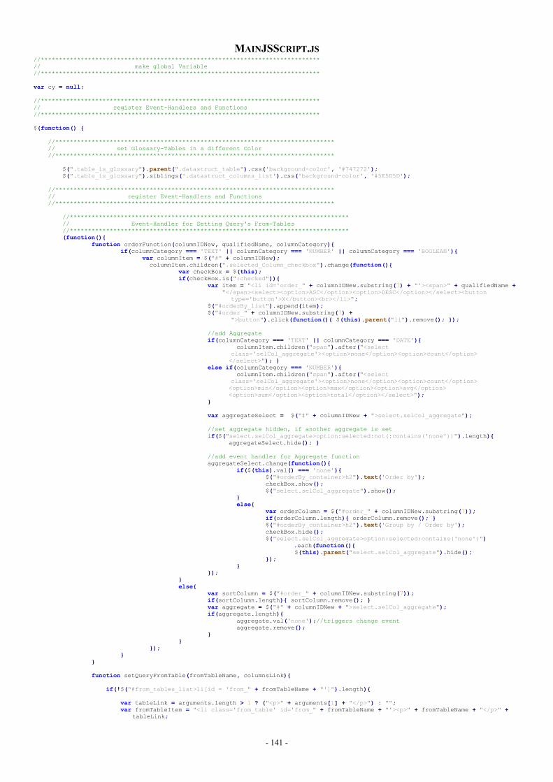
- 141 -
MAINJSSCRIPT.JS//*****************************************************************************// make global Variable//*****************************************************************************
var cy = null;
//*****************************************************************************// register Event-Handlers and Functions//*****************************************************************************
$(function() {
//*****************************************************************************// set Glossary-Tables in a different Color//*****************************************************************************
$(".table_is_glossary").parent(".datastruct_table").css('background-color', '#747272');$(".table_is_glossary").siblings('.datastruct_columns_list').css('background-color', '#5E5D5D');
//*****************************************************************************// register Event-Handlers and Functions//*****************************************************************************
//*****************************************************************************// Event-Handler for Setting Query's From-Tables//*****************************************************************************(function(){
function orderFunction(columnIDNew, qualifiedName, columnCategory){if(columnCategory === 'TEXT' || columnCategory === 'NUMBER' || columnCategory === 'BOOLEAN'){
var columnItem = $("#" + columnIDNew);columnItem.children(".selected_Column_checkbox").change(function(){
var checkBox = $(this);if(checkBox.is(":checked")){
var item = "<li id='order_" + columnIDNew.substring(7) + "'><span>" + qualifiedName +"</span><select><option>ASC</option><option>DESC</option></select><button
type='button'>X</button><br></li>";$("#orderBy_list").append(item);$("#order_" + columnIDNew.substring(7) +
">button").click(function(){ $(this).parent("li").remove(); });
//add Aggregateif(columnCategory === 'TEXT' || columnCategory === 'DATE'){
columnItem.children("span").after("<selectclass='selCol_aggregate'><option>none</option><option>count</option></select>"); }
else if(columnCategory === 'NUMBER'){columnItem.children("span").after("<select
class='selCol_aggregate'><option>none</option><option>count</option><option>min</option><option>max</option><option>avg</option><option>sum</option><option>total</option></select>");
}
var aggregateSelect = $("#" + columnIDNew + ">select.selCol_aggregate");
//set aggregate hidden, if another aggregate is setif($("select.selCol_aggregate>option:selected:not(:contains('none'))").length){
aggregateSelect.hide(); }
//add event handler for Aggregate functionaggregateSelect.change(function(){
if($(this).val() === 'none'){$("#orderBy_container>h2").text('Order by');checkBox.show();$("select.selCol_aggregate").show();
}else{
var orderColumn = $("#order_" + columnIDNew.substring(7));if(orderColumn.length){ orderColumn.remove(); }$("#orderBy_container>h2").text('Group by / Order by');checkBox.hide();$("select.selCol_aggregate>option:selected:contains('none')")
.each(function(){$(this).parent("select.selCol_aggregate").hide();
});}
});}else{
var sortColumn = $("#order_" + columnIDNew.substring(7));if(sortColumn.length){ sortColumn.remove(); }var aggregate = $("#" + columnIDNew + ">select.selCol_aggregate");if(aggregate.length){
aggregate.val('none');//triggers change eventaggregate.remove();
}}
});}
}
function setQueryFromTable(fromTableName, columnsLink){
if(!$("#from_tables_list>li[id = 'from_" + fromTableName + "']").length){
var tableLink = arguments.length > 1 ? ("<p>" + arguments[1] + "</p>") : "";var fromTableItem = "<li class='from_table' id='from_" + fromTableName + "'><p>" + fromTableName + "</p>" +
tableLink;
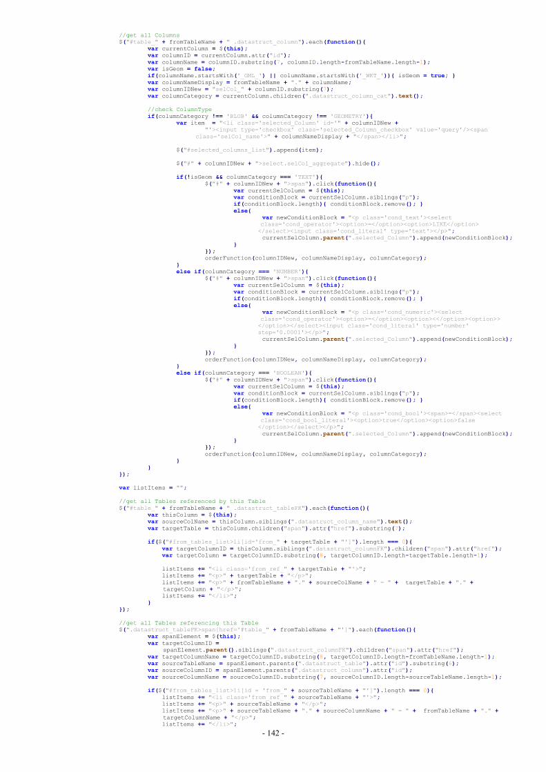
- 142 -
//get all Columns$("#table_" + fromTableName + " .datastruct_column").each(function(){
var currentColumn = $(this);var columnID = currentColumn.attr("id");var columnName = columnID.substring(7, columnID.length-fromTableName.length-1);var isGeom = false;if(columnName.startsWith('_GML_') || columnName.startsWith('_WKT_')){ isGeom = true; }var columnNameDisplay = fromTableName + "." + columnName;var columnIDNew = "selCol_" + columnID.substring(7);var columnCategory = currentColumn.children(".datastruct_column_cat").text();
//check ColumnTypeif(columnCategory !== 'BLOB' && columnCategory !== 'GEOMETRY'){
var item = "<li class='selected_Column' id='" + columnIDNew +"'><input type='checkbox' class='selected_Column_checkbox' value='query'/><span
class='selCol_name'>" + columnNameDisplay + "</span></li>";
$("#selected_columns_list").append(item);
$("#" + columnIDNew + ">select.selCol_aggregate").hide();
if(!isGeom && columnCategory === 'TEXT'){$("#" + columnIDNew + ">span").click(function(){
var currentSelColumn = $(this);var conditionBlock = currentSelColumn.siblings("p");if(conditionBlock.length){ conditionBlock.remove(); }else{
var newConditionBlock = "<p class='cond_text'><selectclass='cond_operator'><option>=</option><option>LIKE</option></select><input class='cond_literal' type='text'></p>";currentSelColumn.parent(".selected_Column").append(newConditionBlock);
}});orderFunction(columnIDNew, columnNameDisplay, columnCategory);
}else if(columnCategory === 'NUMBER'){
$("#" + columnIDNew + ">span").click(function(){var currentSelColumn = $(this);var conditionBlock = currentSelColumn.siblings("p");if(conditionBlock.length){ conditionBlock.remove(); }else{
var newConditionBlock = "<p class='cond_numeric'><selectclass='cond_operator'><option>=</option><option><</option><option>></option></select><input class='cond_literal' type='number'step='0.0001'></p>";currentSelColumn.parent(".selected_Column").append(newConditionBlock);
}});orderFunction(columnIDNew, columnNameDisplay, columnCategory);
}else if(columnCategory === 'BOOLEAN'){
$("#" + columnIDNew + ">span").click(function(){var currentSelColumn = $(this);var conditionBlock = currentSelColumn.siblings("p");if(conditionBlock.length){ conditionBlock.remove(); }else{
var newConditionBlock = "<p class='cond_bool'><span>=</span><selectclass='cond_bool_literal'><option>true</option><option>false</option></select></p>";currentSelColumn.parent(".selected_Column").append(newConditionBlock);
}});orderFunction(columnIDNew, columnNameDisplay, columnCategory);
}}
});
var listItems = "";
//get all Tables referenced by this Table$("#table_" + fromTableName + " .datastruct_tableFK").each(function(){
var thisColumn = $(this);var sourceColName = thisColumn.siblings(".datastruct_column_name").text();var targetTable = thisColumn.children("span").attr("href").substring(7);
if($("#from_tables_list>li[id='from_" + targetTable + "']").length === 0){var targetColumnID = thisColumn.siblings(".datastruct_columnFK").children("span").attr("href");var targetColumn = targetColumnID.substring(8, targetColumnID.length-targetTable.length-1);
listItems += "<li class='from_ref_" + targetTable + "'>";listItems += "<p>" + targetTable + "</p>";listItems += "<p>" + fromTableName + "." + sourceColName + " = " + targetTable + "." +targetColumn + "</p>";listItems += "</li>";
}});
//get all Tables referencing this Table$(".datastruct_tableFK>span[href='#table_" + fromTableName + "']").each(function(){
var spanElement = $(this);var targetColumnID =
spanElement.parent().siblings(".datastruct_columnFK").children("span").attr("href");var targetColumnName = targetColumnID.substring(8, targetColumnID.length-fromTableName.length-1);var sourceTableName = spanElement.parents(".datastruct_table").attr("id").substring(6);var sourceColumnID = spanElement.parents(".datastruct_column").attr("id");var sourceColumnName = sourceColumnID.substring(7, sourceColumnID.length-sourceTableName.length-1);
if($("#from_tables_list>li[id = 'from_" + sourceTableName + "']").length === 0){listItems += "<li class='from_ref_" + sourceTableName + "'>";listItems += "<p>" + sourceTableName + "</p>";listItems += "<p>" + sourceTableName + "." + sourceColumnName + " = " + fromTableName + "." +targetColumnName + "</p>";listItems += "</li>";
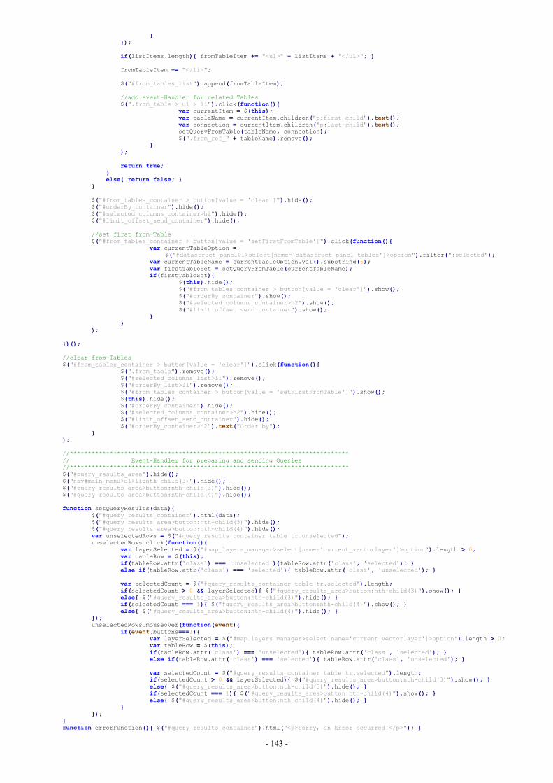
- 143 -
}});
if(listItems.length){ fromTableItem += "<ul>" + listItems + "</ul>"; }
fromTableItem += "</li>";
$("#from_tables_list").append(fromTableItem);
//add event-Handler for related Tables$(".from_table > ul > li").click(function(){
var currentItem = $(this);var tableName = currentItem.children("p:first-child").text();var connection = currentItem.children("p:last-child").text();setQueryFromTable(tableName, connection);$(".from_ref_" + tableName).remove();
});
return true;}else{ return false; }
}
$("#from_tables_container > button[value = 'clear']").hide();$("#orderBy_container").hide();$("#selected_columns_container>h2").hide();$("#limit_offset_send_container").hide();
//set first from-Table$("#from_tables_container > button[value = 'setFirstFromTable']").click(function(){
var currentTableOption =$("#datastruct_panel01>select[name='datastruct_panel_tables']>option").filter(":selected");
var currentTableName = currentTableOption.val().substring(6);var firstTableSet = setQueryFromTable(currentTableName);if(firstTableSet){
$(this).hide();$("#from_tables_container > button[value = 'clear']").show();$("#orderBy_container").show();$("#selected_columns_container>h2").show();$("#limit_offset_send_container").show();
}}
);
})();
//clear from-Tables$("#from_tables_container > button[value = 'clear']").click(function(){
$(".from_table").remove();$("#selected_columns_list>li").remove();$("#orderBy_list>li").remove();$("#from_tables_container > button[value = 'setFirstFromTable']").show();$(this).hide();$("#orderBy_container").hide();$("#selected_columns_container>h2").hide();$("#limit_offset_send_container").hide();$("#orderBy_container>h2").text("Order by");
});
//*****************************************************************************// Event-Handler for preparing and sending Queries//*****************************************************************************$("#query_results_area").hide();$("nav#main_menu>ul>li:nth-child(3)").hide();$("#query_results_area>button:nth-child(3)").hide();$("#query_results_area>button:nth-child(4)").hide();
function setQueryResults(data){$("#query_results_container").html(data);$("#query_results_area>button:nth-child(3)").hide();$("#query_results_area>button:nth-child(4)").hide();var unselectedRows = $("#query_results_container table tr.unselected");unselectedRows.click(function(){
var layerSelected = $("#map_layers_manager>select[name='current_vectorlayer']>option").length > 0;var tableRow = $(this);if(tableRow.attr('class') === 'unselected'){tableRow.attr('class', 'selected'); }else if(tableRow.attr('class') === 'selected'){ tableRow.attr('class', 'unselected'); }
var selectedCount = $("#query_results_container table tr.selected").length;if(selectedCount > 0 && layerSelected){ $("#query_results_area>button:nth-child(3)").show(); }else{ $("#query_results_area>button:nth-child(3)").hide(); }if(selectedCount === 1){ $("#query_results_area>button:nth-child(4)").show(); }else{ $("#query_results_area>button:nth-child(4)").hide(); }
});unselectedRows.mouseover(function(event){
if(event.buttons===1){var layerSelected = $("#map_layers_manager>select[name='current_vectorlayer']>option").length > 0;var tableRow = $(this);if(tableRow.attr('class') === 'unselected'){ tableRow.attr('class', 'selected'); }else if(tableRow.attr('class') === 'selected'){ tableRow.attr('class', 'unselected'); }
var selectedCount = $("#query_results_container table tr.selected").length;if(selectedCount > 0 && layerSelected){ $("#query_results_area>button:nth-child(3)").show(); }else{ $("#query_results_area>button:nth-child(3)").hide(); }if(selectedCount === 1){ $("#query_results_area>button:nth-child(4)").show(); }else{ $("#query_results_area>button:nth-child(4)").hide(); }
}});
}function errorFunction(){ $("#query_results_container").html("<p>Sorry, an Error occurred!</p>"); }
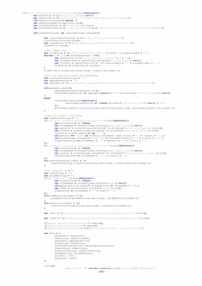
- 144 -
$("#limit_offset_send_container>button").click(function(){var datastruct = $("#datastruct_name").text();var repository = $("#repositories_list input[name='Repository']:checked");if(!repository.length){ return; }var repositoryName = repository.val();var fromTablesCount = $(".from_table").length;var selectedColumns = $(".selected_Column").has("input[class='selected_Column_checkbox']:checked");
if(fromTablesCount>0 && selectedColumns.length>0){
var limitOffestContainer = $("#limit_offset_send_container");limitOffestContainer.hide();var clearButton = $("#from_tables_container>button[value='clear']");clearButton.hide();
//get 'FROM' Linevar fromString = $(".from_table:nth-of-type(1)").attr("id").substring(5) + ";";for(var i = 2; i <= fromTablesCount; i++){
var tableToJoin = $(".from_table:nth-of-type(" + i + ")");var joinedColumns = tableToJoin.children("p:nth-child(2)").text();var joinStmt = tableToJoin.attr("id").substring(5) + "(" + joinedColumns + ");";fromString = fromString + joinStmt;
}fromString = fromString.substring(0, fromString.length-1);
//get all selected Columns and Aggregatesvar selectedColumnsString = "";var aggregateString = "";var aggregate = $("select.selCol_aggregate>option:selected:not(:contains('none'))");
if(aggregate.length){aggregateString = aggregate.val();selectedColumnsString += aggregate.parent("select").siblings("span.selCol_name").text();
}else{
selectedColumns.each(function(){selectedColumnsString += $(this).children("span.selCol_name").text() + ";";
});selectedColumnsString = selectedColumnsString.substring(0, selectedColumnsString.length-1);
}
//get all Columns' conditionsvar conditionsString = "";$(".selected_Column:has(select.cond_operator)").each(function(){
var currentColumn = $(this);var columnName = currentColumn.children("span.selCol_name").text();var operator = currentColumn.children("p").children("select.cond_operator").val();var literal = currentColumn.children("p").children("input.cond_literal").val();literal = literal.replace(/'/g, "\\'");if(operator === 'LIKE' && !literal.includes('%')){ literal = '%' + literal + '%'; }if(currentColumn.children("p.cond_text").length){ literal = "'" + literal + "'"; }conditionsString += columnName + ';' + operator + ';' + literal + ";";
});$(".selected_Column:has(select.cond_bool_literal)").each(function(){
var currentColumn = $(this);var columnName = currentColumn.children("span.selCol_name").text();var literal = currentColumn.children("p").children("select.cond_bool_literal").val();conditionsString += columnName + ';=;' + literal + ";";
});if(conditionsString.length > 0){
conditionsString = conditionsString.substring(0, conditionsString.length-1);}
//get ordering Columnsvar orderString = "";var groupByString = "";$("#orderBy_list>li").each(function(){
var currentColumn = $(this);var columnName = currentColumn.children("span").text();if(aggregateString.length){ groupByString += columnName + ";"; }var order = currentColumn.children("select").val();orderString += columnName + ";" + order + ";";
});if(groupByString.length > 0){
groupByString = groupByString.substring(0, groupByString.length-1);}if(orderString.length > 0){
orderString = orderString.substring(0, orderString.length-1);}
var limit = $("#limit_offset_send_container>input[name='query_limit']").val();
var offset = $("#limit_offset_send_container>input[name='query_offset']").val();
$("#query_results_container>table").remove();$("#query_results_container>p").remove();$("#query_results_container").html("<p>retrieving data... please wait</p>");
var data = {datastruct: datastruct,repository: repositoryName,aggregate: aggregateString,fromString: fromString,selectedColumnsString: selectedColumnsString,orderString: orderString,conditionsString: conditionsString,groupByString: groupByString,sqlLimit: limit,sqlOffset: offset
};
$.ajax({url: "http://" + $(window.location).attr('hostname') + "/Query.php",
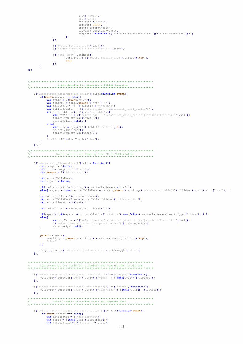
- 145 -
type: "POST",data: data,dataType : 'html',timeout: 20000,error: errorFunction,success: setQueryResults,complete: function(){ limitOffestContainer.show(); clearButton.show(); }
});
$("#query_results_area").show();$("nav#main_menu>ul>li:nth-child(3)").show();
$("html, body").animate({scrollTop : $("#query_results_area").offset().top },1000
);}
});
//*****************************************************************************// Event-Handler for Datastruct-Tables-Dropdown//*****************************************************************************
$(".datastruct_table>p:first-child").click(function(event){if(event.target === this){
var table = $(event.target);var tableID = table.parent().attr("id");var colListID = "#" + tableID + "_columns";var tablesDropDown = $('select[name = "datastruct_panel_tables"]');if(table.siblings("ul").is(":visible")){
var topValue = $('select[name = "datastruct_panel_tables"]>option:first-child').val();tablesDropDown.val(topValue);selectHelper(null); }
else{var node = cy.$('#' + tableID.substring(6));selectHelper(node);tablesDropDown.val(tableID);
}$(colListID).slideToggle("slow");
}});
//*****************************************************************************// Event-Handler for Jumping from FK to Table/Column//*****************************************************************************
$(".datastruct_FK>span[href]").click(function(){var target = $(this);var href = target.attr("href");var parent = $('#datastruct');
var wantedTableName;var expand = false;
if(href.startsWith('#table_')){ wantedTableName = href; }else{ expand = true; wantedTableName = target.parent().siblings(".datastruct_tableFK").children("span").attr("href"); }
var wantedTable = $(wantedTableName);var wantedTableNameItem = wantedTable.children("p:first-child");var wantedElement = $(href);
var columnsList = wantedTable.children("ul");
if(expand){ if(expand && columnsList.is(":visible") === false){ wantedTableNameItem.trigger('click'); } }else{
var topValue = $('select[name = "datastruct_panel_tables"]>option:first-child').val();$('select[name = "datastruct_panel_tables"]').val(topValue);selectHelper(null);
}
parent.animate({scrollTop : parent.scrollTop() + wantedElement.position().top },'slow'
);
target.parents(".datastruct_columns_list").slideToggle("slow");});
//*****************************************************************************// Event-Handler for Assigning LineWidth and Text-Height to Diagram//*****************************************************************************
$('select[name="datastruct_panel_linewidth"]').on('change', function(){cy.style().selector('edge').style( {'width' : $(this).val() }).update();
});
$('select[name="datastruct_panel_fontheight"]').on('change', function(){cy.style().selector('node').style( {'font-size' : $(this).val() }).update();
});
//*****************************************************************************// Event-Handler selecting Table by Dropdown-Menu//*****************************************************************************
$('select[name = "datastruct_panel_tables"]').change(function(event){if(event.target === this){
var datastruct = $('#datastruct');var table = $(this).val().substring(6);var wantedTable = $('#table_' + table);
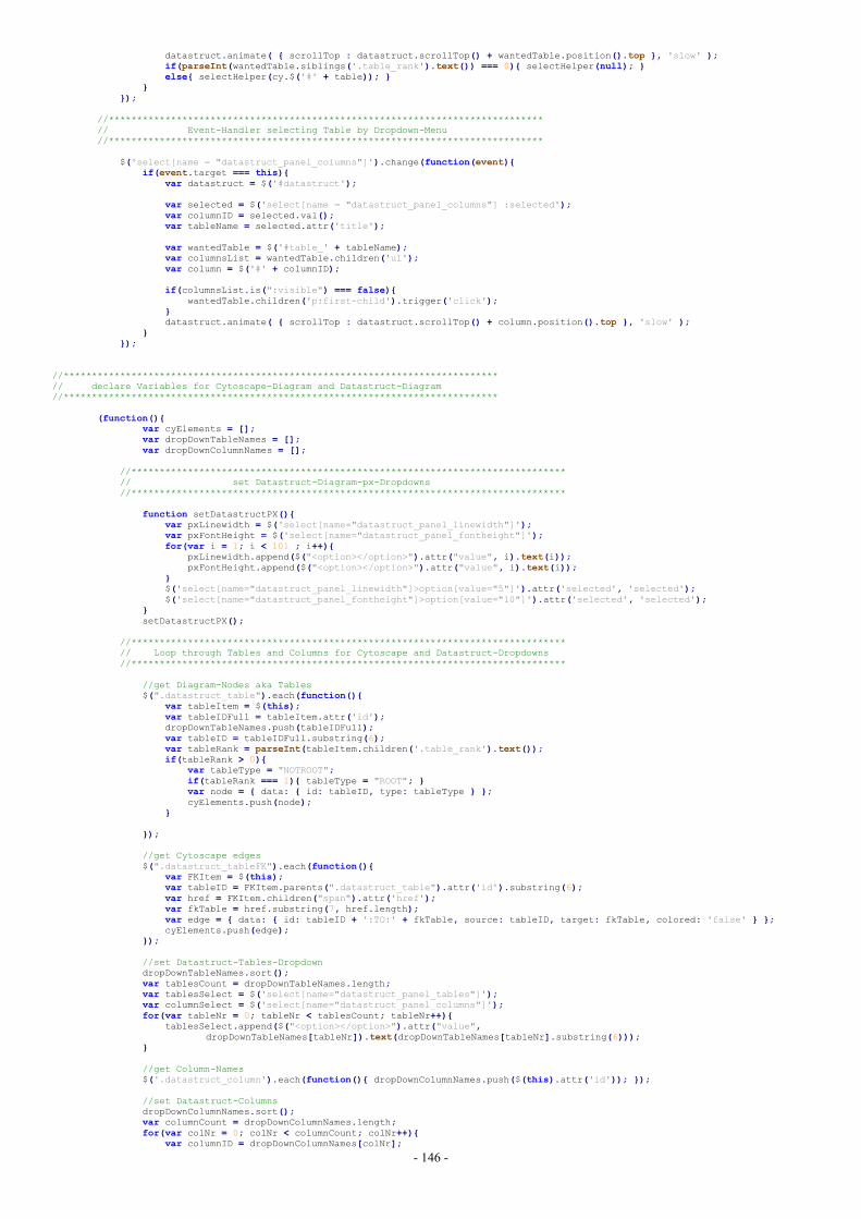
- 146 -
datastruct.animate( { scrollTop : datastruct.scrollTop() + wantedTable.position().top }, 'slow' );if(parseInt(wantedTable.siblings('.table_rank').text()) === 0){ selectHelper(null); }else{ selectHelper(cy.$('#' + table)); }
}});
//*****************************************************************************// Event-Handler selecting Table by Dropdown-Menu//*****************************************************************************
$('select[name = "datastruct_panel_columns"]').change(function(event){if(event.target === this){
var datastruct = $('#datastruct');
var selected = $('select[name = "datastruct_panel_columns"] :selected');var columnID = selected.val();var tableName = selected.attr('title');
var wantedTable = $('#table_' + tableName);var columnsList = wantedTable.children('ul');var column = $('#' + columnID);
if(columnsList.is(":visible") === false){wantedTable.children('p:first-child').trigger('click');
}datastruct.animate( { scrollTop : datastruct.scrollTop() + column.position().top }, 'slow' );
}});
//*****************************************************************************// declare Variables for Cytoscape-Diagram and Datastruct-Diagram//*****************************************************************************
(function(){var cyElements = [];var dropDownTableNames = [];var dropDownColumnNames = [];
//*****************************************************************************// set Datastruct-Diagram-px-Dropdowns//*****************************************************************************
function setDatastructPX(){var pxLinewidth = $('select[name="datastruct_panel_linewidth"]');var pxFontHeight = $('select[name="datastruct_panel_fontheight"]');for(var i = 1; i < 101 ; i++){
pxLinewidth.append($("<option></option>").attr("value", i).text(i));pxFontHeight.append($("<option></option>").attr("value", i).text(i));
}$('select[name="datastruct_panel_linewidth"]>option[value="5"]').attr('selected', 'selected');$('select[name="datastruct_panel_fontheight"]>option[value="10"]').attr('selected', 'selected');
}setDatastructPX();
//*****************************************************************************// Loop through Tables and Columns for Cytoscape and Datastruct-Dropdowns//*****************************************************************************
//get Diagram-Nodes aka Tables$(".datastruct_table").each(function(){
var tableItem = $(this);var tableIDFull = tableItem.attr('id');dropDownTableNames.push(tableIDFull);var tableID = tableIDFull.substring(6);var tableRank = parseInt(tableItem.children('.table_rank').text());if(tableRank > 0){
var tableType = "NOTROOT";if(tableRank === 1){ tableType = "ROOT"; }var node = { data: { id: tableID, type: tableType } };cyElements.push(node);
}
});
//get Cytoscape edges$(".datastruct_tableFK").each(function(){
var FKItem = $(this);var tableID = FKItem.parents(".datastruct_table").attr('id').substring(6);var href = FKItem.children("span").attr('href');var fkTable = href.substring(7, href.length);var edge = { data: { id: tableID + ':TO:' + fkTable, source: tableID, target: fkTable, colored: 'false' } };cyElements.push(edge);
});
//set Datastruct-Tables-DropdowndropDownTableNames.sort();var tablesCount = dropDownTableNames.length;var tablesSelect = $('select[name="datastruct_panel_tables"]');var columnSelect = $('select[name="datastruct_panel_columns"]');for(var tableNr = 0; tableNr < tablesCount; tableNr++){
tablesSelect.append($("<option></option>").attr("value",dropDownTableNames[tableNr]).text(dropDownTableNames[tableNr].substring(6)));
}
//get Column-Names$('.datastruct_column').each(function(){ dropDownColumnNames.push($(this).attr('id')); });
//set Datastruct-ColumnsdropDownColumnNames.sort();var columnCount = dropDownColumnNames.length;for(var colNr = 0; colNr < columnCount; colNr++){
var columnID = dropDownColumnNames[colNr];
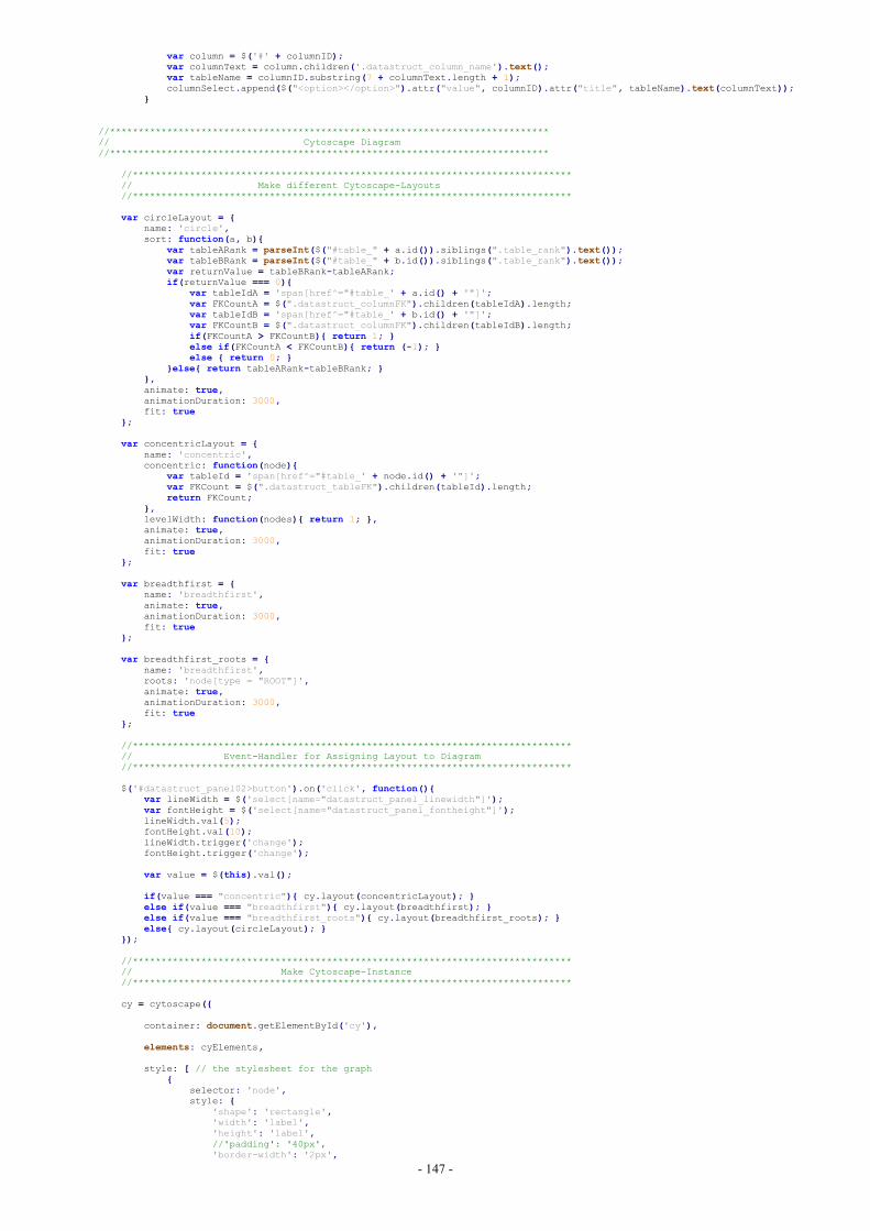
- 147 -
var column = $('#' + columnID);var columnText = column.children('.datastruct_column_name').text();var tableName = columnID.substring(7 + columnText.length + 1);columnSelect.append($("<option></option>").attr("value", columnID).attr("title", tableName).text(columnText));
}
//*****************************************************************************// Cytoscape Diagram//*****************************************************************************
//*****************************************************************************// Make different Cytoscape-Layouts//*****************************************************************************
var circleLayout = {name: 'circle',sort: function(a, b){
var tableARank = parseInt($("#table_" + a.id()).siblings(".table_rank").text());var tableBRank = parseInt($("#table_" + b.id()).siblings(".table_rank").text());var returnValue = tableBRank-tableARank;if(returnValue === 0){
var tableIdA = 'span[href^="#table_' + a.id() + '"]';var FKCountA = $(".datastruct_columnFK").children(tableIdA).length;var tableIdB = 'span[href^="#table_' + b.id() + '"]';var FKCountB = $(".datastruct_columnFK").children(tableIdB).length;if(FKCountA > FKCountB){ return 1; }else if(FKCountA < FKCountB){ return (-1); }else { return 0; }
}else{ return tableARank-tableBRank; }},animate: true,animationDuration: 3000,fit: true
};
var concentricLayout = {name: 'concentric',concentric: function(node){
var tableId = 'span[href^="#table_' + node.id() + '"]';var FKCount = $(".datastruct_tableFK").children(tableId).length;return FKCount;
},levelWidth: function(nodes){ return 1; },animate: true,animationDuration: 3000,fit: true
};
var breadthfirst = {name: 'breadthfirst',animate: true,animationDuration: 3000,fit: true
};
var breadthfirst_roots = {name: 'breadthfirst',roots: 'node[type = "ROOT"]',animate: true,animationDuration: 3000,fit: true
};
//*****************************************************************************// Event-Handler for Assigning Layout to Diagram//*****************************************************************************
$('#datastruct_panel02>button').on('click', function(){var lineWidth = $('select[name="datastruct_panel_linewidth"]');var fontHeight = $('select[name="datastruct_panel_fontheight"]');lineWidth.val(5);fontHeight.val(10);lineWidth.trigger('change');fontHeight.trigger('change');
var value = $(this).val();
if(value === "concentric"){ cy.layout(concentricLayout); }else if(value === "breadthfirst"){ cy.layout(breadthfirst); }else if(value === "breadthfirst_roots"){ cy.layout(breadthfirst_roots); }else{ cy.layout(circleLayout); }
});
//*****************************************************************************// Make Cytoscape-Instance//*****************************************************************************
cy = cytoscape({
container: document.getElementById('cy'),
elements: cyElements,
style: [ // the stylesheet for the graph{
selector: 'node',style: {
'shape': 'rectangle','width': 'label','height': 'label',//'padding': '40px','border-width': '2px',
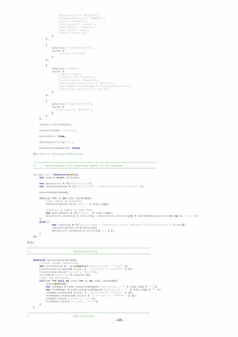
- 148 -
'border-color': '#4d0000','background-color': '#4d0000','color': '#ff9933','text-valign': 'center','text-hlign': 'center','font-size': '10px','label': 'data(id)'
}},
{selector: 'node:selected',style: {
'color': '#ffff00'}
},
{selector: 'edge',style: {
'width': '5px','line-color': '#ffffff','curve-style': 'haystack','mid-target-arrow-color': '#ffffff','mid-target-arrow-shape': 'triangle-backcurve','mid-target-arrow-fill': 'filled'
}},
{selector: 'edge:selected',style: {'line-color': '#CC8F33',
}}
],
layout: circleLayout,
selectionType: 'single',
motionBlur: true,
wheelSensitivity: 0.2,
boxSelectionEnabled: false
});//End of Cytoscape-Definition
//*****************************************************************************// Event-Handler for selecting Tables in the Diagram//*****************************************************************************
cy.on('tap', function(event){var node = event.cyTarget;
var datastruct = $('#datastruct');var tablesDropDown = $('select[name = "datastruct_panel_tables"]');
selectHelper(node);
if(node !== cy && node.isNode()){//set Table in DropdowntablesDropDown.val('table_' + node.id());
//Scroll to Table in left Panevar wantedTable = $('#table_' + node.id());datastruct.animate( { scrollTop : datastruct.scrollTop() + wantedTable.position().top }, 'slow' );
}else {
var topValue = $('select[name = "datastruct_panel_tables"]>option:first-child').val();tablesDropDown.val(topValue);datastruct.animate( { scrollTop : 0 } );
}});
})();
//*****************************************************************************// Helperfunctions//*****************************************************************************
function selectHelper(node){//clear former Selectionsvar currColored = cy.elements('edge[colored = "true"]');currColored.animate({ style: { 'line-color': '#ffffff' } });currColored.data('colored', 'false');cy.nodes(':selected').unselect();//set new Selectionif(node !== null && node !== cy && node.isNode()){
node.select();var toEdges = node.connectedEdges('edge[target = "' + node.id() + '"]');var fromEdges = node.connectedEdges('edge[source = "' + node.id() + '"]');toEdges.animate({ style: { 'line-color': '#ff0000' } });fromEdges.animate({ style: { 'line-color': '#0066ff' } });toEdges.data('colored', 'true');fromEdges.data('colored', 'true');
}}
//*****************************************************************************// Map-Functions
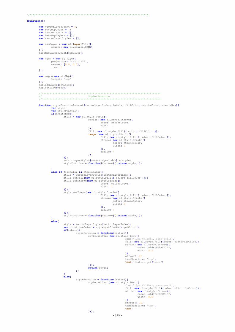
- 149 -
//*****************************************************************************
(function(){
var vectorLayerCount = 0;var basemapCount = 1;var vectorLayers = [];var baseMapLayers = [];var vectorLayerStyles = [];
var osmLayer = new ol.layer.Tile({source: new ol.source.OSM()
});baseMapLayers.push(osmLayer);
var view = new ol.View({projection: 'EPSG:3857',center: [0.0, 0.0],zoom: 1
});
var map = new ol.Map({target: 'map'
});map.addLayer(osmLayer);map.setView(view);
//*****************************************************************************// Style-Function//*****************************************************************************
function styleFunctionAutomat(vectorLayerIndex, labels, fillColor, strokeColor, createNew){var style;var styleFunction;if(createNew){
style = new ol.style.Style({stroke: new ol.style.Stroke({
color: strokeColor,width: 1
}),fill: new ol.style.Fill({ color: fillColor }),image: new ol.style.Circle({
fill: new ol.style.Fill({ color: fillColor }),stroke: new ol.style.Stroke({
color: strokeColor,width: 1
}),radius: 4
})});vectorLayerStyles[vectorLayerIndex] = style;styleFunction = function(feature){ return style; };
}else if(fillColor && strokeColor){
style = vectorLayerStyles[vectorLayerIndex];style.setFill(new ol.style.Fill({ color: fillColor }));style.setStroke(new ol.style.Stroke({
color: strokeColor,width: 1
}));style.setImage(new ol.style.Circle({
fill: new ol.style.Fill({ color: fillColor }),stroke: new ol.style.Stroke({
color: strokeColor,width: 1
}),radius: 4
}));styleFunction = function(feature){ return style; };
}else{
style = vectorLayerStyles[vectorLayerIndex];var oldstrokeColor = style.getStroke().getColor();if(labels){
styleFunction = function(feature){style.setText(new ol.style.Text({
font:'12px Calibri, sans-serif',fill: new ol.style.Fill({color: oldstrokeColor}),stroke: new ol.style.Stroke({
color: oldstrokeColor,width: 0.5
}),offsetY: 20,textBaseline: 'top',text: feature.get('name')
}));return style;
};}else{
styleFunction = function(feature){style.setText(new ol.style.Text({
font:'12px Calibri, sans-serif',fill: new ol.style.Fill({color: oldstrokeColor}),stroke: new ol.style.Stroke({
color: oldstrokeColor,width: 0.5
}),offsetY: 20,textBaseline: 'top',text: ''
}));
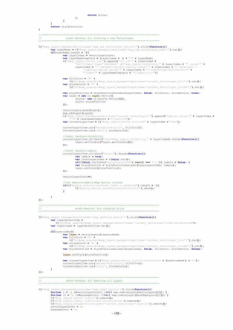
- 150 -
return style;};
}}return styleFunction;
}
//*****************************************************************************// event-Handler for Creating a new Vectorlayer//*****************************************************************************
$("#map_layers_manager>button[name='map_new_vectorlayer_button']").click(function(){var layerName = $("#map_layers_manager>input[name='map_new_vectorlayer_name']").val();if(layerName.length > 0){
var layerIndex = vectorLayerCount;var layerNameComplete = (layerIndex + 1) + "-" + layerName;$("#map_layers_vector_list").append("<li id='" + layerIndex +
"vec'><input type='checkbox' id='map_layers_visibility_" + layerIndex + "' value='" +layerIndex + "' checked/><select><option value='" + layerIndex + "' selected>---
</option><option value='" + layerIndex + "'>labels</option></select>" +"<label>" + layerNameComplete + "</label></li>");
var fillColor = '#' +$("div#map_area>div#map_layers_manager>input[name='current_vectorlayer_fill']").val();
var strokeColor = '#' +$("div#map_area>div#map_layers_manager>input[name='current_vectorlayer_stroke']").val();
var styleFunction = styleFunctionAutomat(layerIndex, false, fillColor, strokeColor, true);var Layer = new ol.layer.Vector({
source: new ol.source.Vector({}),style: styleFunction
});
vectorLayers.push(Layer);map.addLayer(Layer);$("#map_layers_manager>select[name='current_vectorlayer']").append("<option value='" + layerIndex +
"'>" + layerNameComplete + "</option>");var currentLayerItem = $("#map_layers_vector_list>li#" + layerIndex + "vec");
currentLayerItem.css('background-color', fillColor);currentLayerItem.css('color', strokeColor);
//event Handler-VisibilitycurrentLayerItem.children("input#map_layers_visibility_" + layerIndex).change(function(){
Layer.setVisible(!Layer.getVisible());});
//event Handler-LabelscurrentLayerItem.children("select").change(function(){
var labels = true;var localLayerIndex = $(this).val();if($(this).children("option:selected").text() === "---"){ labels = false; }var styleFunction = styleFunctionAutomat(localLayerIndex, labels);Layer.setStyle(styleFunction);
});
vectorLayerCount++;
//set Results-Add-to-Map Button visibleif($("#query_results_container table tr.selected").length > 0){
$("#query_results_area>button:nth-child(3)").show();}
}});
//*****************************************************************************// event-Handler for changing Style//*****************************************************************************
$("#map_layers_manager>button[name='map_setStyle_button']").click(function(){var layerSelectItem =
$("div#map_area>div#map_layers_manager>select[name='current_vectorlayer']>option:selected");var layerindex = layerSelectItem.val();
if(layerindex){var layer = vectorLayers[layerindex];var fillColor = '#' +
$("div#map_area>div#map_layers_manager>input[name='current_vectorlayer_fill']").val();var strokeColor = '#' +
$("div#map_area>div#map_layers_manager>input[name='current_vectorlayer_stroke']").val();var styleFunction = styleFunctionAutomat(layerindex, false, fillColor, strokeColor, false);
layer.setStyle(styleFunction);
var currentLayerItem = $("#map_layers_vector_list>li:nth-child(" + (layerindex+1) + ")");currentLayerItem.css('background-color', fillColor);currentLayerItem.css('color', strokeColor);
}});
//*****************************************************************************// event-Handler for Removing all Layers//*****************************************************************************
$("#map_layers_manager>button[name='map_reset_button']").click(function(){for(var i = 0; i<vectorLayerCount; i++){ map.removeLayer(vectorLayers[i]); }for(var i2 = 1; i2<basemapCount; i2++){ map.removeLayer(baseMapLayers[i2]); }$("#map_layers_vector_list>li").remove();$("#map_layers_raster_list>li:not(:first-child)").remove();$("#map_layers_manager>select[name='current_vectorlayer']>option").remove();vectorLayerCount = 0;basemapCount = 1;
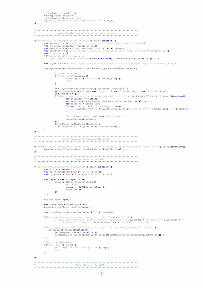
- 151 -
vectorLayers.length = 0;baseMapLayers.length = 1;vectorLayerStyles.length = 0;$("#query_results_area>button:nth-child(3)").hide();
});
//*****************************************************************************// event-Handler for Adding Vector data to Map//*****************************************************************************
$("#query_results_area>button:nth-child(3)").click(function(){var geomInput = $("#query_results_container th input[type='radio']:checked");var checkedGeomTHIndex = geomInput.val();var geomColName = geomInput.siblings("label").text().replace(".", "\n");var geomType = $("#query_results_container th:has(input[type='radio']:checked)").attr('class');var idIndices = [];$("#query_results_container th
input[type='checkbox']:checked").each(function(){ idIndices.push($(this).val()); });
var layerIndex = $("#map_layers_manager>select[name='current_vectorlayer']>option:selected").val();
if(layerIndex && checkedGeomTHIndex && geomType && idIndices.length>0){
//scroll to Map-Area$("html, body").animate({
scrollTop : $("#map_area").offset().top },1000
);
var layerSource = vectorLayers[layerIndex].getSource();var formatReader = geomType === 'gml_lit' ? new ol.format.GML(): new ol.format.WKT();var features = [];$("#query_results_container tr.selected>td:nth-child(" + checkedGeomTHIndex + ")").each(function(){
var currentRow = $(this);var feature = formatReader.readFeatures(currentRow.text()).pop();var idString = geomColName;for(var i = 0; i < idIndices.length; i++){
idString += "\n" + currentRow.siblings("td:nth-child(" + idIndices[i] + ")").text();}
feature.set('name', idString);//OR SET AS IDfeatures.push(feature);
});layerSource.addFeatures(features);view.fit(layerSource.getExtent(), map.getSize());
}});
//*****************************************************************************// Event-Handler for basemap-Visibility//*****************************************************************************
$("div#map_layers_area>ul#map_layers_raster_list>li:first-child>input#map_basmaps_visibility_0").change(function(){baseMapLayers[0].setVisible(!baseMapLayers[0].getVisible());
});
//*****************************************************************************// Event-Handler for WMS//*****************************************************************************
$("div#wms_wfs_area>div#wms_area>button").click(function(){var button = $(this);var url = button.siblings("#wms_url").val();var layerName = button.siblings("#wms_layer").val();
var layer = new ol.layer.Tile({source: new ol.source.TileWMS({
url: url,params: { LAYERS: layerName },hidpi: false
})});
map.addLayer(layer);
var layerindex = basemapCount++;baseMapLayers[layerindex] = layer;
var layerNameComplete = layerindex + "-" + layerName;
$("div#map_layers_area>ul#map_layers_raster_list").append("<li>" +"<input type='checkbox' id='map_basmaps_visibility_" + layerindex + "' value='" + layerindex + "'
checked/>" + "<label>" + layerNameComplete + "</label>" + "</li>");
$("div#map_layers_area>ul#map_layers_raster_list>li>input#map_basmaps_visibility_" +layerindex).change(function(){
var basemapIndex = $(this).val();baseMapLayers[basemapIndex].setVisible(!baseMapLayers[basemapIndex].getVisible());
});
//scroll to Map-Area$("html, body").animate({
scrollTop : $("#map_area").offset().top },1000
);
});
//*****************************************************************************// Event-Handler for WFS//*****************************************************************************
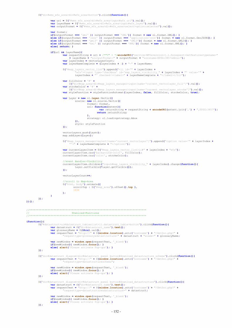
- 152 -
$("div#wms_wfs_area>div#wfs_area>button").click(function(){
var url = $("#wms_wfs_area>div#wfs_area>input#wfs_url").val();var layerName = $("#wms_wfs_area>div#wfs_area>input#wfs_layer").val();var outputFormat = $("#wms_wfs_area>div#wfs_area>select>option:selected").val();
var format;if(outputFormat === 'gml' || outputFormat === 'GML'){ format = new ol.format.GML(); }else if(outputFormat === 'json' || outputFormat === 'application/json'){ format = new ol.format.GeoJSON(); }else if(outputFormat === 'gml3' || outputFormat === 'GML3'){ format = new ol.format.GML3(); }else if(outputFormat === 'kml' || outputFormat === 'KML'){ format = new ol.format.KML(); }else{ return; }
if(url && layerName){var requestString = url + /*"?" + */encodeURI("service=WFS&version=1.1.0&request=GetFeature&typename="
+ layerName + "&outputFormat=" + outputFormat + "&srsname=EPSG:3857&bbox=");var layerIndex = vectorLayerCount;var layerNameComplete = (layerIndex + 1) + "-" + layerName;
$("#map_layers_vector_list").append("<li id='" + layerIndex +"wfs'><input type='checkbox' id='map_layers_visibility_" + layerIndex + "' value='" +layerIndex + "' checked/><label>" + layerNameComplete + "</label></li>");
var fillColor = '#' +$("div#map_area>div#map_layers_manager>input[name='current_vectorlayer_fill']").val();
var strokeColor = '#' +$("div#map_area>div#map_layers_manager>input[name='current_vectorlayer_stroke']").val();
var styleFunction = styleFunctionAutomat(layerIndex, false, fillColor, strokeColor, true);
var Layer = new ol.layer.Vector({source: new ol.source.Vector({
format: format,url: function(extent){
var returnString = requestString + encodeURI(extent.join(',') + ",EPSG:3857");return returnString;
},strategy: ol.loadingstrategy.bbox
}),style: styleFunction
});
vectorLayers.push(Layer);map.addLayer(Layer);
$("#map_layers_manager>select[name='current_vectorlayer']").append("<option value='" + layerIndex +"'>" + layerNameComplete + "</option>");
var currentLayerItem = $("#map_layers_vector_list>li#" + layerIndex + "wfs");currentLayerItem.css('background-color', fillColor);currentLayerItem.css('color', strokeColor);
//event Handler-VisibilitycurrentLayerItem.children("input#map_layers_visibility_" + layerIndex).change(function(){
Layer.setVisible(!Layer.getVisible());});
vectorLayerCount++;
//scroll to Map-Area$("html, body").animate({
scrollTop : $("#map_area").offset().top },1000
);}
});})();
//*****************************************************************************// Download-Functions//*****************************************************************************
(function(){$("#datastruct>ul#datastruct_tableslist>li.datastruct_table>button").click(function(){
var datastruct = $("div#datastruct_name").text();var glossaryName = $(this).val();var requestText = "http://" + $(window.location).attr('hostname') + "/GetDoc.php?" +
"requesttype=glossary&datastructure=" + datastruct + "&name=" + glossaryName;
var newWindow = window.open(requestText, '_blank');if(newWindow){ newWindow.focus(); }else{ alert('Please activate Pop-ups'); }
});
$("div#datastruct_diagram>div#datastruct_panel button#download_datastructure_schema").click(function(){var requestText = "http://" + $(window.location).attr('hostname') + "/GetDoc.php?" +
"requesttype=datastructureschema";
var newWindow = window.open(requestText, '_blank');if(newWindow){ newWindow.focus(); }else{ alert('Please activate Pop-ups'); }
});
$("div#datastruct_diagram>div#datastruct_panel button#download_datastructure").click(function(){var datastruct = $("div#datastruct_name").text();var requestText = "http://" + $(window.location).attr('hostname') + "/GetDoc.php?" +
"requesttype=datastructure&datastructure=" + datastruct;
var newWindow = window.open(requestText, '_blank');if(newWindow){ newWindow.focus(); }else{ alert('Please activate Pop-ups'); }
});
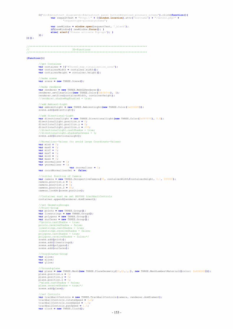
- 153 -
$("div#datastruct_diagram>div#datastruct_panel button#download_glossary_schema").click(function(){var requestText = "http://" + $(window.location).attr('hostname') + "/GetDoc.php?" +
"requesttype=glossaryschema";
var newWindow = window.open(requestText, '_blank');if(newWindow){ newWindow.focus(); }else{ alert('Please activate Pop-ups'); }
});})();
//*****************************************************************************// 3D-Functions//*****************************************************************************
(function(){
//get Containervar container = $("#ThreeD_map_visualisation_area");var containerWidth = container.width();var containerHeight = container.height();
//make scenevar scene = new THREE.Scene();
//make renderervar renderer = new THREE.WebGLRenderer();renderer.setClearColor(new THREE.Color(0xb3b3cc), 1);renderer.setSize(containerWidth, containerHeight);//renderer.shadowMapEnabled = true;
//add Ambient-Lightvar ambientLight = new THREE.AmbientLight(new THREE.Color(0xCCDDFF));scene.add(ambientLight);
//add Directional-Lightvar directionalLight = new THREE.DirectionalLight(new THREE.Color(0xFFFFFF), 0.8);directionalLight.position.x = 0;directionalLight.position.y = 0;directionalLight.position.z = 400;//directionalLight.castShadow = true;//directionalLight.shadowDarkness = 1;scene.add(directionalLight);
//Normalizer-Values (to avoid large Coordinate-Values)var minX = 0;var maxX = 0;var minY = 0;var maxY = 0;var minZ = 0;var maxZ = 0;var xnormalizer = 0;var ynormalizer = 0;
var znormalizer = 0;var coordNormalizerSet = false;
//initial Position of Cameravar camera = new THREE.PerspectiveCamera(45, containerWidth/containerHeight, 0.1, 100000);camera.position.x = 0;camera.position.y = 0;camera.position.z = 80;camera.lookAt(scene.position);
//Container must me set BEFORE trachballControlscontainer.append(renderer.domElement);
//set GeometryGroups//Point-Groupvar points = new THREE.Group();var linestrings = new THREE.Group();var polygons = new THREE.Group();var surfaces = new THREE.Group();/*points.castShadow = true;points.receiveShadow = false;linestrings.castShadow = true;linestrings.receiveShadow = false;polygons.castShadow = true;polygons.receiveShadow = false;*/scene.add(points);scene.add(linestrings);scene.add(polygons);scene.add(surfaces);
//Coordinates-Groupvar zline;var xline;var yline;
//Ground-planevar plane = new THREE.Mesh(new THREE.PlaneGeometry(60,60,1,1), new THREE.MeshLambertMaterial({color: 0x4D4D4D}));plane.position.x = 0;plane.position.y = 0;plane.position.z = 0;/*plane.castShadow = false;plane.receiveShadow = true;*/scene.add(plane);
//set Controlsvar trackballControls = new THREE.TrackballControls(camera, renderer.domElement);trackballControls.rotateSpeed = 5.0;trackballControls.zoomSpeed = 1.5;trackballControls.panSpeed = 1.0;var clock = new THREE.Clock();
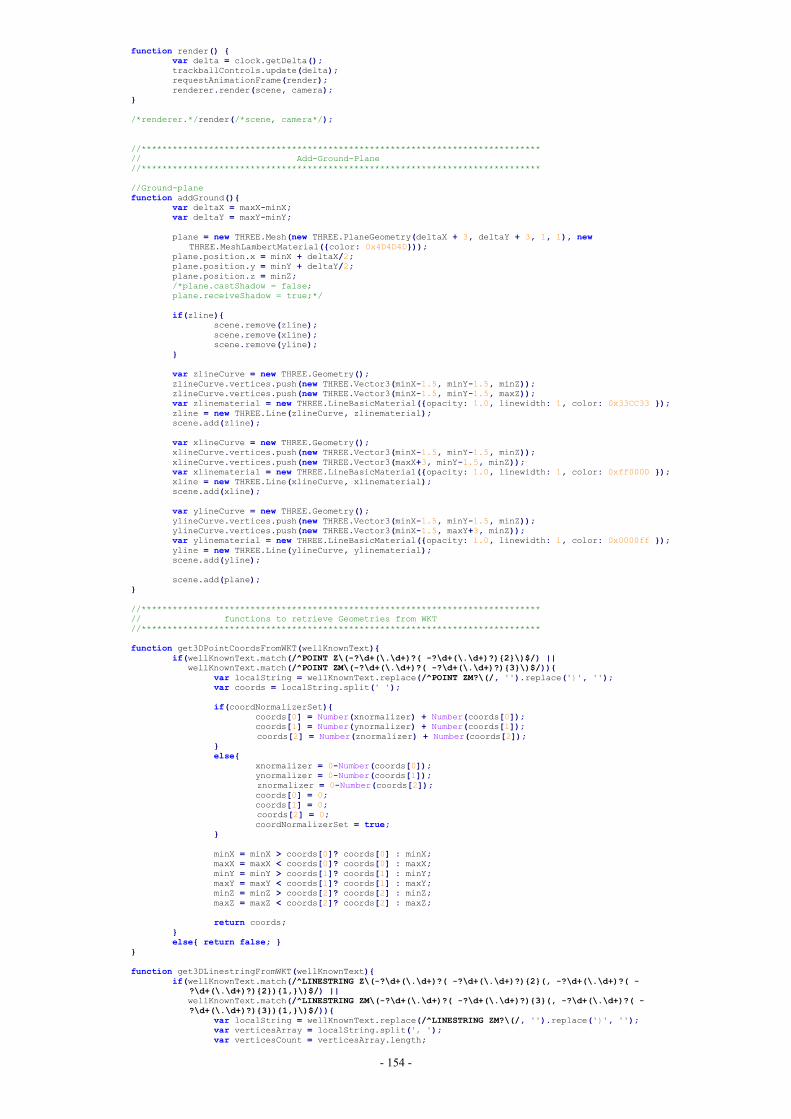
- 154 -
function render() {var delta = clock.getDelta();trackballControls.update(delta);requestAnimationFrame(render);renderer.render(scene, camera);
}
/*renderer.*/render(/*scene, camera*/);
//*****************************************************************************// Add-Ground-Plane//*****************************************************************************
//Ground-planefunction addGround(){
var deltaX = maxX-minX;var deltaY = maxY-minY;
plane = new THREE.Mesh(new THREE.PlaneGeometry(deltaX + 3, deltaY + 3, 1, 1), newTHREE.MeshLambertMaterial({color: 0x4D4D4D}));
plane.position.x = minX + deltaX/2;plane.position.y = minY + deltaY/2;plane.position.z = minZ;/*plane.castShadow = false;plane.receiveShadow = true;*/
if(zline){scene.remove(zline);scene.remove(xline);scene.remove(yline);
}
var zlineCurve = new THREE.Geometry();zlineCurve.vertices.push(new THREE.Vector3(minX-1.5, minY-1.5, minZ));zlineCurve.vertices.push(new THREE.Vector3(minX-1.5, minY-1.5, maxZ));var zlinematerial = new THREE.LineBasicMaterial({opacity: 1.0, linewidth: 1, color: 0x33CC33 });zline = new THREE.Line(zlineCurve, zlinematerial);scene.add(zline);
var xlineCurve = new THREE.Geometry();xlineCurve.vertices.push(new THREE.Vector3(minX-1.5, minY-1.5, minZ));xlineCurve.vertices.push(new THREE.Vector3(maxX+3, minY-1.5, minZ));var xlinematerial = new THREE.LineBasicMaterial({opacity: 1.0, linewidth: 1, color: 0xff0000 });xline = new THREE.Line(xlineCurve, xlinematerial);scene.add(xline);
var ylineCurve = new THREE.Geometry();ylineCurve.vertices.push(new THREE.Vector3(minX-1.5, minY-1.5, minZ));ylineCurve.vertices.push(new THREE.Vector3(minX-1.5, maxY+3, minZ));var ylinematerial = new THREE.LineBasicMaterial({opacity: 1.0, linewidth: 1, color: 0x0000ff });yline = new THREE.Line(ylineCurve, ylinematerial);scene.add(yline);
scene.add(plane);}
//*****************************************************************************// functions to retrieve Geometries from WKT//*****************************************************************************
function get3DPointCoordsFromWKT(wellKnownText){if(wellKnownText.match(/^POINT Z\(-?\d+(\.\d+)?( -?\d+(\.\d+)?){2}\)$/) ||
wellKnownText.match(/^POINT ZM\(-?\d+(\.\d+)?( -?\d+(\.\d+)?){3}\)$/)){var localString = wellKnownText.replace(/^POINT ZM?\(/, '').replace(')', '');var coords = localString.split(' ');
if(coordNormalizerSet){coords[0] = Number(xnormalizer) + Number(coords[0]);coords[1] = Number(ynormalizer) + Number(coords[1]);coords[2] = Number(znormalizer) + Number(coords[2]);
}else{
xnormalizer = 0-Number(coords[0]);ynormalizer = 0-Number(coords[1]);znormalizer = 0-Number(coords[2]);coords[0] = 0;coords[1] = 0;coords[2] = 0;coordNormalizerSet = true;
}
minX = minX > coords[0]? coords[0] : minX;maxX = maxX < coords[0]? coords[0] : maxX;minY = minY > coords[1]? coords[1] : minY;maxY = maxY < coords[1]? coords[1] : maxY;minZ = minZ > coords[2]? coords[2] : minZ;maxZ = maxZ < coords[2]? coords[2] : maxZ;
return coords;}else{ return false; }
}
function get3DLinestringFromWKT(wellKnownText){if(wellKnownText.match(/^LINESTRING Z\(-?\d+(\.\d+)?( -?\d+(\.\d+)?){2}(, -?\d+(\.\d+)?( -
?\d+(\.\d+)?){2}){1,}\)$/) ||wellKnownText.match(/^LINESTRING ZM\(-?\d+(\.\d+)?( -?\d+(\.\d+)?){3}(, -?\d+(\.\d+)?( -?\d+(\.\d+)?){3}){1,}\)$/)){
var localString = wellKnownText.replace(/^LINESTRING ZM?\(/, '').replace(')', '');var verticesArray = localString.split(', ');var verticesCount = verticesArray.length;
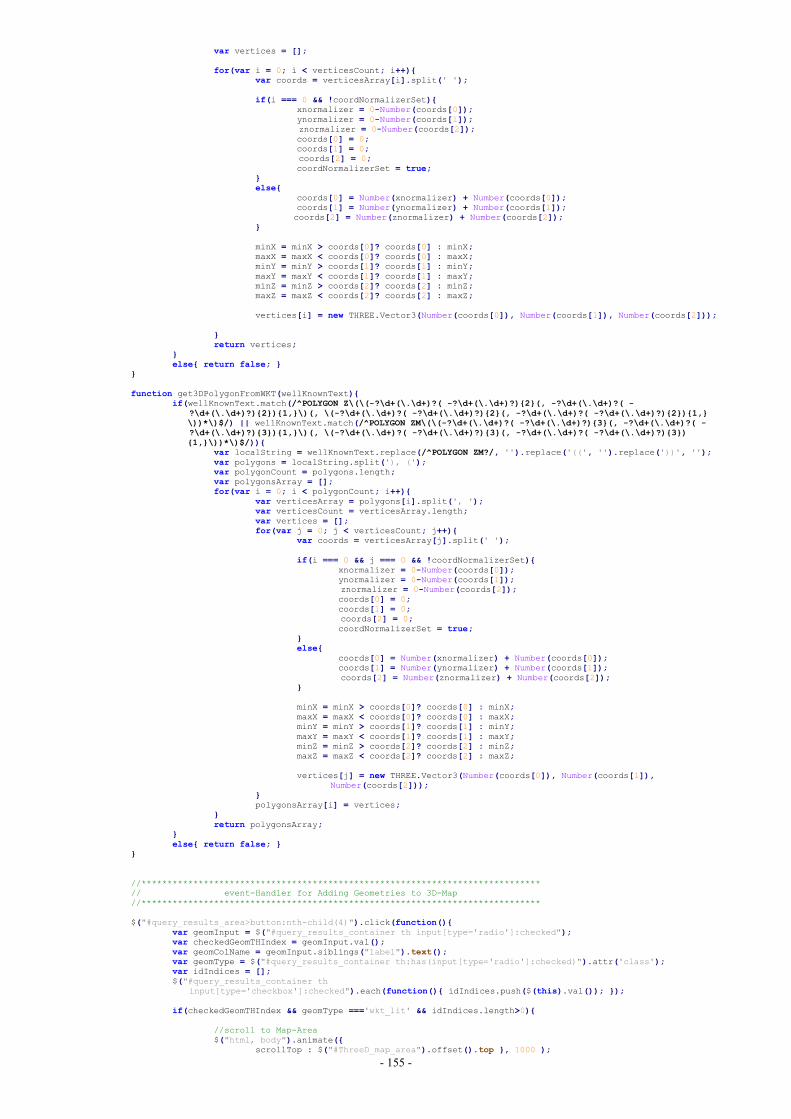
- 155 -
var vertices = [];
for(var i = 0; i < verticesCount; i++){var coords = verticesArray[i].split(' ');
if(i === 0 && !coordNormalizerSet){xnormalizer = 0-Number(coords[0]);ynormalizer = 0-Number(coords[1]);znormalizer = 0-Number(coords[2]);coords[0] = 0;coords[1] = 0;coords[2] = 0;coordNormalizerSet = true;
}else{
coords[0] = Number(xnormalizer) + Number(coords[0]);coords[1] = Number(ynormalizer) + Number(coords[1]);coords[2] = Number(znormalizer) + Number(coords[2]);
}
minX = minX > coords[0]? coords[0] : minX;maxX = maxX < coords[0]? coords[0] : maxX;minY = minY > coords[1]? coords[1] : minY;maxY = maxY < coords[1]? coords[1] : maxY;minZ = minZ > coords[2]? coords[2] : minZ;maxZ = maxZ < coords[2]? coords[2] : maxZ;
vertices[i] = new THREE.Vector3(Number(coords[0]), Number(coords[1]), Number(coords[2]));
}return vertices;
}else{ return false; }
}
function get3DPolygonFromWKT(wellKnownText){if(wellKnownText.match(/^POLYGON Z\(\(-?\d+(\.\d+)?( -?\d+(\.\d+)?){2}(, -?\d+(\.\d+)?( -
?\d+(\.\d+)?){2}){1,}\)(, \(-?\d+(\.\d+)?( -?\d+(\.\d+)?){2}(, -?\d+(\.\d+)?( -?\d+(\.\d+)?){2}){1,}\))*\)$/) || wellKnownText.match(/^POLYGON ZM\(\(-?\d+(\.\d+)?( -?\d+(\.\d+)?){3}(, -?\d+(\.\d+)?( -?\d+(\.\d+)?){3}){1,}\)(, \(-?\d+(\.\d+)?( -?\d+(\.\d+)?){3}(, -?\d+(\.\d+)?( -?\d+(\.\d+)?){3}){1,}\))*\)$/)){
var localString = wellKnownText.replace(/^POLYGON ZM?/, '').replace('((', '').replace('))', '');var polygons = localString.split('), (');var polygonCount = polygons.length;var polygonsArray = [];for(var i = 0; i < polygonCount; i++){
var verticesArray = polygons[i].split(', ');var verticesCount = verticesArray.length;var vertices = [];for(var j = 0; j < verticesCount; j++){
var coords = verticesArray[j].split(' ');
if(i === 0 && j === 0 && !coordNormalizerSet){xnormalizer = 0-Number(coords[0]);ynormalizer = 0-Number(coords[1]);znormalizer = 0-Number(coords[2]);coords[0] = 0;coords[1] = 0;coords[2] = 0;coordNormalizerSet = true;
}else{
coords[0] = Number(xnormalizer) + Number(coords[0]);coords[1] = Number(ynormalizer) + Number(coords[1]);coords[2] = Number(znormalizer) + Number(coords[2]);
}
minX = minX > coords[0]? coords[0] : minX;maxX = maxX < coords[0]? coords[0] : maxX;minY = minY > coords[1]? coords[1] : minY;maxY = maxY < coords[1]? coords[1] : maxY;minZ = minZ > coords[2]? coords[2] : minZ;maxZ = maxZ < coords[2]? coords[2] : maxZ;
vertices[j] = new THREE.Vector3(Number(coords[0]), Number(coords[1]),Number(coords[2]));
}polygonsArray[i] = vertices;
}return polygonsArray;
}else{ return false; }
}
//*****************************************************************************// event-Handler for Adding Geometries to 3D-Map//*****************************************************************************
$("#query_results_area>button:nth-child(4)").click(function(){var geomInput = $("#query_results_container th input[type='radio']:checked");var checkedGeomTHIndex = geomInput.val();var geomColName = geomInput.siblings("label").text();var geomType = $("#query_results_container th:has(input[type='radio']:checked)").attr('class');var idIndices = [];$("#query_results_container th
input[type='checkbox']:checked").each(function(){ idIndices.push($(this).val()); });
if(checkedGeomTHIndex && geomType ==='wkt_lit' && idIndices.length>0){
//scroll to Map-Area$("html, body").animate({
scrollTop : $("#ThreeD_map_area").offset().top }, 1000 );
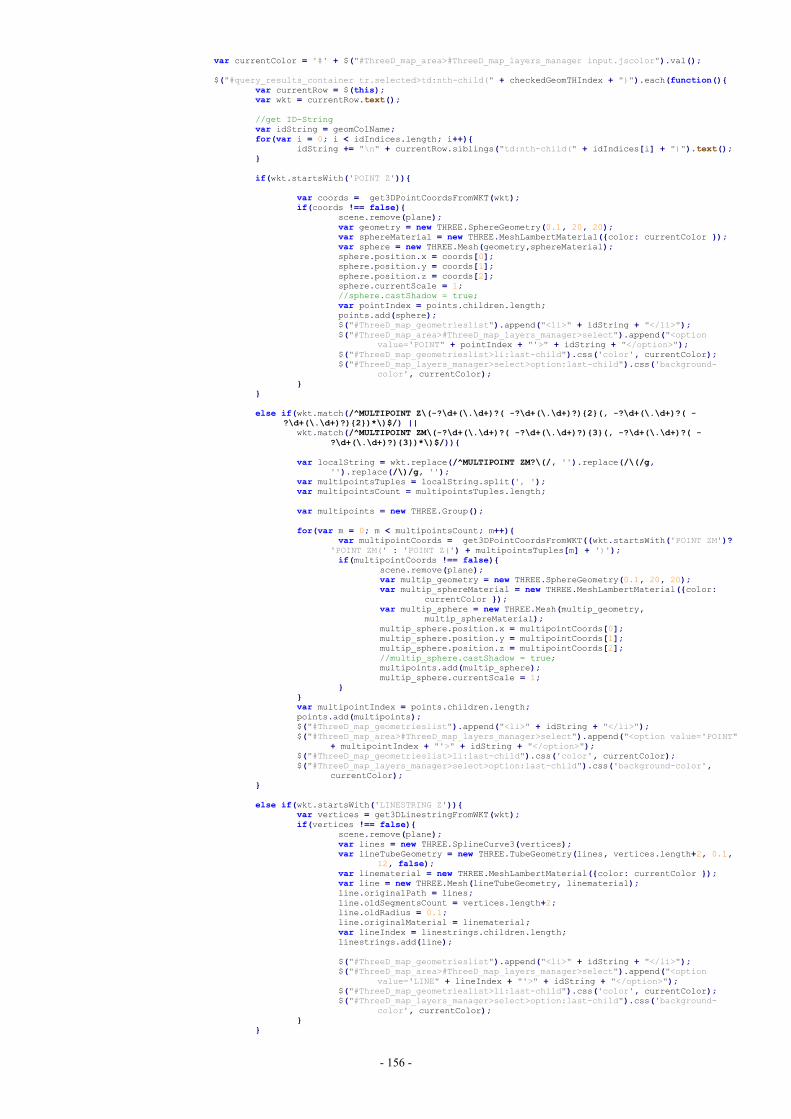
- 156 -
var currentColor = '#' + $("#ThreeD_map_area>#ThreeD_map_layers_manager input.jscolor").val();
$("#query_results_container tr.selected>td:nth-child(" + checkedGeomTHIndex + ")").each(function(){var currentRow = $(this);var wkt = currentRow.text();
//get ID-Stringvar idString = geomColName;for(var i = 0; i < idIndices.length; i++){
idString += "\n" + currentRow.siblings("td:nth-child(" + idIndices[i] + ")").text();}
if(wkt.startsWith('POINT Z')){
var coords = get3DPointCoordsFromWKT(wkt);if(coords !== false){
scene.remove(plane);var geometry = new THREE.SphereGeometry(0.1, 20, 20);var sphereMaterial = new THREE.MeshLambertMaterial({color: currentColor });var sphere = new THREE.Mesh(geometry,sphereMaterial);sphere.position.x = coords[0];sphere.position.y = coords[1];sphere.position.z = coords[2];sphere.currentScale = 1;//sphere.castShadow = true;var pointIndex = points.children.length;points.add(sphere);$("#ThreeD_map_geometrieslist").append("<li>" + idString + "</li>");$("#ThreeD_map_area>#ThreeD_map_layers_manager>select").append("<option
value='POINT" + pointIndex + "'>" + idString + "</option>");$("#ThreeD_map_geometrieslist>li:last-child").css('color', currentColor);$("#ThreeD_map_layers_manager>select>option:last-child").css('background-
color', currentColor);}
}
else if(wkt.match(/^MULTIPOINT Z\(-?\d+(\.\d+)?( -?\d+(\.\d+)?){2}(, -?\d+(\.\d+)?( -?\d+(\.\d+)?){2})*\)$/) ||
wkt.match(/^MULTIPOINT ZM\(-?\d+(\.\d+)?( -?\d+(\.\d+)?){3}(, -?\d+(\.\d+)?( -?\d+(\.\d+)?){3})*\)$/)){
var localString = wkt.replace(/^MULTIPOINT ZM?\(/, '').replace(/\(/g,'').replace(/\)/g, '');
var multipointsTuples = localString.split(', ');var multipointsCount = multipointsTuples.length;
var multipoints = new THREE.Group();
for(var m = 0; m < multipointsCount; m++){var multipointCoords = get3DPointCoordsFromWKT((wkt.startsWith('POINT ZM')?
'POINT ZM(' : 'POINT Z(') + multipointsTuples[m] + ')');if(multipointCoords !== false){
scene.remove(plane);var multip_geometry = new THREE.SphereGeometry(0.1, 20, 20);var multip_sphereMaterial = new THREE.MeshLambertMaterial({color:
currentColor });var multip_sphere = new THREE.Mesh(multip_geometry,
multip_sphereMaterial);multip_sphere.position.x = multipointCoords[0];multip_sphere.position.y = multipointCoords[1];multip_sphere.position.z = multipointCoords[2];//multip_sphere.castShadow = true;multipoints.add(multip_sphere);multip_sphere.currentScale = 1;
}}var multipointIndex = points.children.length;points.add(multipoints);$("#ThreeD_map_geometrieslist").append("<li>" + idString + "</li>");$("#ThreeD_map_area>#ThreeD_map_layers_manager>select").append("<option value='POINT"
+ multipointIndex + "'>" + idString + "</option>");$("#ThreeD_map_geometrieslist>li:last-child").css('color', currentColor);$("#ThreeD_map_layers_manager>select>option:last-child").css('background-color',
currentColor);}
else if(wkt.startsWith('LINESTRING Z')){var vertices = get3DLinestringFromWKT(wkt);if(vertices !== false){
scene.remove(plane);var lines = new THREE.SplineCurve3(vertices);var lineTubeGeometry = new THREE.TubeGeometry(lines, vertices.length+2, 0.1,
12, false);var linematerial = new THREE.MeshLambertMaterial({color: currentColor });var line = new THREE.Mesh(lineTubeGeometry, linematerial);line.originalPath = lines;line.oldSegmentsCount = vertices.length+2;line.oldRadius = 0.1;line.originalMaterial = linematerial;var lineIndex = linestrings.children.length;linestrings.add(line);
$("#ThreeD_map_geometrieslist").append("<li>" + idString + "</li>");$("#ThreeD_map_area>#ThreeD_map_layers_manager>select").append("<option
value='LINE" + lineIndex + "'>" + idString + "</option>");$("#ThreeD_map_geometrieslist>li:last-child").css('color', currentColor);$("#ThreeD_map_layers_manager>select>option:last-child").css('background-
color', currentColor);}
}
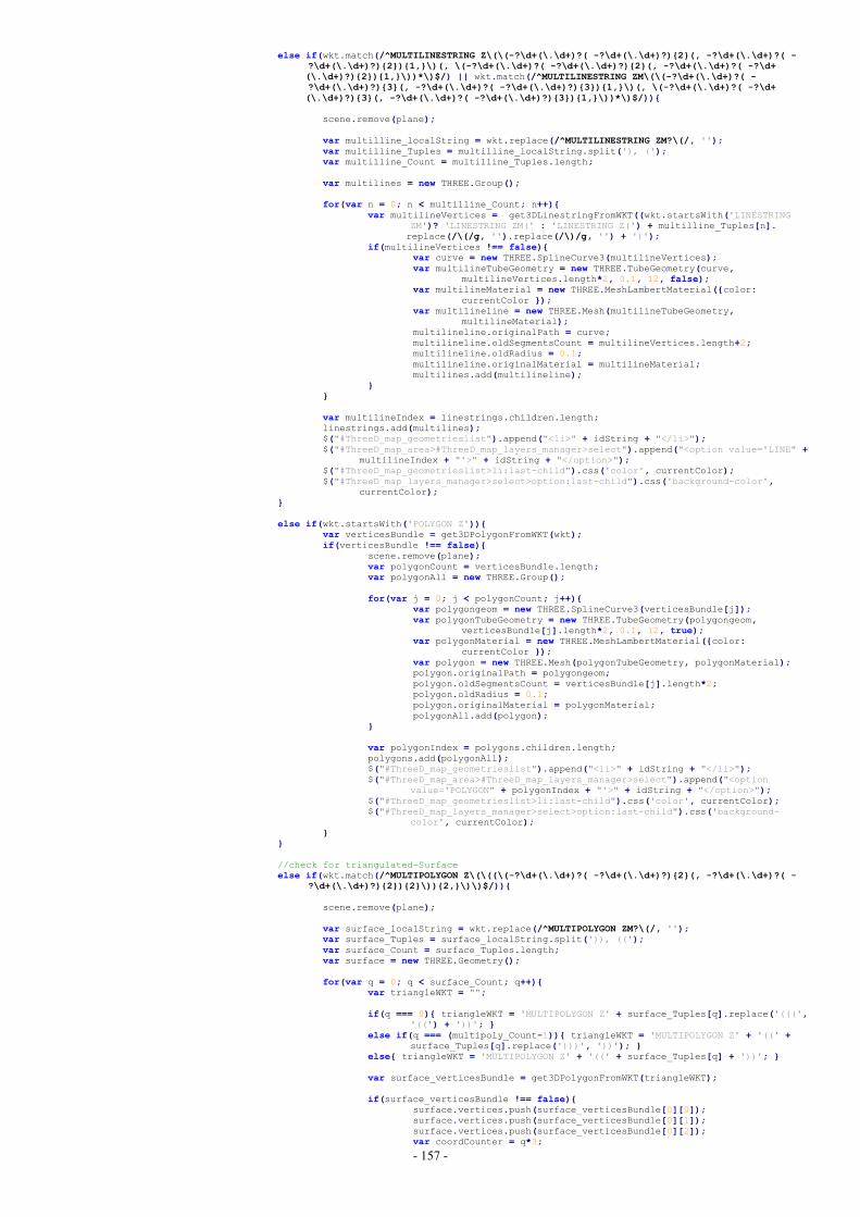
- 157 -
else if(wkt.match(/^MULTILINESTRING Z\(\(-?\d+(\.\d+)?( -?\d+(\.\d+)?){2}(, -?\d+(\.\d+)?( -?\d+(\.\d+)?){2}){1,}\)(, \(-?\d+(\.\d+)?( -?\d+(\.\d+)?){2}(, -?\d+(\.\d+)?( -?\d+(\.\d+)?){2}){1,}\))*\)$/) || wkt.match(/^MULTILINESTRING ZM\(\(-?\d+(\.\d+)?( -?\d+(\.\d+)?){3}(, -?\d+(\.\d+)?( -?\d+(\.\d+)?){3}){1,}\)(, \(-?\d+(\.\d+)?( -?\d+(\.\d+)?){3}(, -?\d+(\.\d+)?( -?\d+(\.\d+)?){3}){1,}\))*\)$/)){
scene.remove(plane);
var multilline_localString = wkt.replace(/^MULTILINESTRING ZM?\(/, '');var multilline_Tuples = multilline_localString.split('), (');var multilline_Count = multilline_Tuples.length;
var multilines = new THREE.Group();
for(var n = 0; n < multilline_Count; n++){var multilineVertices = get3DLinestringFromWKT((wkt.startsWith('LINESTRING
ZM')? 'LINESTRING ZM(' : 'LINESTRING Z(') + multilline_Tuples[n].replace(/\(/g, '').replace(/\)/g, '') + ')');
if(multilineVertices !== false){var curve = new THREE.SplineCurve3(multilineVertices);var multilineTubeGeometry = new THREE.TubeGeometry(curve,
multilineVertices.length*2, 0.1, 12, false);var multilineMaterial = new THREE.MeshLambertMaterial({color:
currentColor });var multilineline = new THREE.Mesh(multilineTubeGeometry,
multilineMaterial);multilineline.originalPath = curve;multilineline.oldSegmentsCount = multilineVertices.length+2;multilineline.oldRadius = 0.1;multilineline.originalMaterial = multilineMaterial;multilines.add(multilineline);
}}
var multilineIndex = linestrings.children.length;linestrings.add(multilines);$("#ThreeD_map_geometrieslist").append("<li>" + idString + "</li>");$("#ThreeD_map_area>#ThreeD_map_layers_manager>select").append("<option value='LINE" +
multilineIndex + "'>" + idString + "</option>");$("#ThreeD_map_geometrieslist>li:last-child").css('color', currentColor);$("#ThreeD_map_layers_manager>select>option:last-child").css('background-color',
currentColor);}
else if(wkt.startsWith('POLYGON Z')){var verticesBundle = get3DPolygonFromWKT(wkt);if(verticesBundle !== false){
scene.remove(plane);var polygonCount = verticesBundle.length;var polygonAll = new THREE.Group();
for(var j = 0; j < polygonCount; j++){var polygongeom = new THREE.SplineCurve3(verticesBundle[j]);var polygonTubeGeometry = new THREE.TubeGeometry(polygongeom,
verticesBundle[j].length*2, 0.1, 12, true);var polygonMaterial = new THREE.MeshLambertMaterial({color:
currentColor });var polygon = new THREE.Mesh(polygonTubeGeometry, polygonMaterial);polygon.originalPath = polygongeom;polygon.oldSegmentsCount = verticesBundle[j].length*2;polygon.oldRadius = 0.1;polygon.originalMaterial = polygonMaterial;polygonAll.add(polygon);
}
var polygonIndex = polygons.children.length;polygons.add(polygonAll);$("#ThreeD_map_geometrieslist").append("<li>" + idString + "</li>");$("#ThreeD_map_area>#ThreeD_map_layers_manager>select").append("<option
value='POLYGON" + polygonIndex + "'>" + idString + "</option>");$("#ThreeD_map_geometrieslist>li:last-child").css('color', currentColor);$("#ThreeD_map_layers_manager>select>option:last-child").css('background-
color', currentColor);}
}
//check for triangulated-Surfaceelse if(wkt.match(/^MULTIPOLYGON Z\(\((\(-?\d+(\.\d+)?( -?\d+(\.\d+)?){2}(, -?\d+(\.\d+)?( -
?\d+(\.\d+)?){2}){2}\)){2,}\)\)$/)){
scene.remove(plane);
var surface_localString = wkt.replace(/^MULTIPOLYGON ZM?\(/, '');var surface_Tuples = surface_localString.split(')), ((');var surface_Count = surface_Tuples.length;var surface = new THREE.Geometry();
for(var q = 0; q < surface_Count; q++){var triangleWKT = "";
if(q === 0){ triangleWKT = 'MULTIPOLYGON Z' + surface_Tuples[q].replace('(((','((') + '))'; }
else if(q === (multipoly_Count-1)){ triangleWKT = 'MULTIPOLYGON Z' + '((' +surface_Tuples[q].replace(')))', '))'); }
else{ triangleWKT = 'MULTIPOLYGON Z' + '((' + surface_Tuples[q] + '))'; }
var surface_verticesBundle = get3DPolygonFromWKT(triangleWKT);
if(surface_verticesBundle !== false){surface.vertices.push(surface_verticesBundle[0][0]);surface.vertices.push(surface_verticesBundle[0][1]);surface.vertices.push(surface_verticesBundle[0][2]);var coordCounter = q*3;
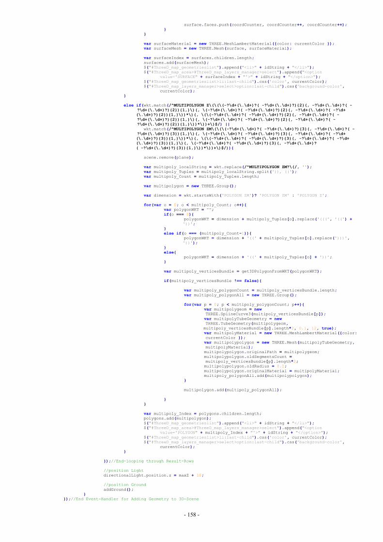
- 158 -
surface.faces.push(coordCounter, coordCounter++, coordCounter++);}
}
var surfaceMaterial = new THREE.MeshLambertMaterial({color: currentColor });var surfaceMesh = new THREE.Mesh(surface, surfaceMaterial);
var surfaceIndex = surfaces.children.length;surfaces.add(surfaceMesh);$("#ThreeD_map_geometrieslist").append("<li>" + idString + "</li>");$("#ThreeD_map_area>#ThreeD_map_layers_manager>select").append("<option
value='SURFACE" + surfaceIndex + "'>" + idString + "</option>");$("#ThreeD_map_geometrieslist>li:last-child").css('color', currentColor);$("#ThreeD_map_layers_manager>select>option:last-child").css('background-color',
currentColor);}
else if(wkt.match(/^MULTIPOLYGON Z\(\(\(-?\d+(\.\d+)?( -?\d+(\.\d+)?){2}(, -?\d+(\.\d+)?( -?\d+(\.\d+)?){2}){1,}\)(, \(-?\d+(\.\d+)?( -?\d+(\.\d+)?){2}(, -?\d+(\.\d+)?( -?\d+(\.\d+)?){2}){1,}\))*\)(, \(\(-?\d+(\.\d+)?( -?\d+(\.\d+)?){2}(, -?\d+(\.\d+)?( -?\d+(\.\d+)?){2}){1,}\)(, \(-?\d+(\.\d+)?( -?\d+(\.\d+)?){2}(, -?\d+(\.\d+)?( -?\d+(\.\d+)?){2}){1,}\))*\))+\)$/) ||
wkt.match(/^MULTIPOLYGON ZM\(\(\(-?\d+(\.\d+)?( -?\d+(\.\d+)?){3}(, -?\d+(\.\d+)?( -?\d+(\.\d+)?){3}){1,}\)(, \(-?\d+(\.\d+)?( -?\d+(\.\d+)?){3}(, -?\d+(\.\d+)?( -?\d+(\.\d+)?){3}){1,}\))*\)(, \(\(-?\d+(\.\d+)?( -?\d+(\.\d+)?){3}(, -?\d+(\.\d+)?( -?\d+(\.\d+)?){3}){1,}\)(, \(-?\d+(\.\d+)?( -?\d+(\.\d+)?){3}(, -?\d+(\.\d+)?( -?\d+(\.\d+)?){3}){1,}\))*\))+\)$/)){
scene.remove(plane);
var multipoly_localString = wkt.replace(/^MULTIPOLYGON ZM?\(/, '');var multipoly_Tuples = multipoly_localString.split(')), ((');var multipoly_Count = multipoly_Tuples.length;
var multipolygon = new THREE.Group();
var dimension = wkt.startsWith('POLYGON ZM')? 'POLYGON ZM' : 'POLYGON Z';
for(var o = 0; o < multipoly_Count; o++){var polygonWKT = "";if(o === 0){
polygonWKT = dimension + multipoly_Tuples[o].replace('(((', '((') +'))';
}else if(o === (multipoly_Count-1)){
polygonWKT = dimension + '((' + multipoly_Tuples[o].replace(')))','))');
}else{
polygonWKT = dimension + '((' + multipoly_Tuples[o] + '))';}
var multipoly_verticesBundle = get3DPolygonFromWKT(polygonWKT);
if(multipoly_verticesBundle !== false){
var multipoly_polygonCount = multipoly_verticesBundle.length;var multipoly_polygonAll = new THREE.Group();
for(var p = 0; p < multipoly_polygonCount; p++){var multipolygeom = newTHREE.SplineCurve3(multipoly_verticesBundle[p]);var multipolyTubeGeometry = newTHREE.TubeGeometry(multipolygeom,multipoly_verticesBundle[p].length*2, 0.1, 12, true);var multipolyMaterial = new THREE.MeshLambertMaterial({color:currentColor });var multipolypolygon = new THREE.Mesh(multipolyTubeGeometry,multipolyMaterial);multipolypolygon.originalPath = multipolygeom;multipolypolygon.oldSegmentsCount =multipoly_verticesBundle[p].length*2;multipolypolygon.oldRadius = 0.1;multipolypolygon.originalMaterial = multipolyMaterial;multipoly_polygonAll.add(multipolypolygon);
}
multipolygon.add(multipoly_polygonAll);
}}
var multipoly_Index = polygons.children.length;polygons.add(multipolygon);$("#ThreeD_map_geometrieslist").append("<li>" + idString + "</li>");$("#ThreeD_map_area>#ThreeD_map_layers_manager>select").append("<option
value='POLYGON" + multipoly_Index + "'>" + idString + "</option>");$("#ThreeD_map_geometrieslist>li:last-child").css('color', currentColor);$("#ThreeD_map_layers_manager>select>option:last-child").css('background-color',
currentColor);}
});//End-looping through Result-Rows
//position LightdirectionalLight.position.z = maxZ + 10;
//position GroundaddGround();
}});//End Event-Handler for Adding Geometry to 3D-Scene
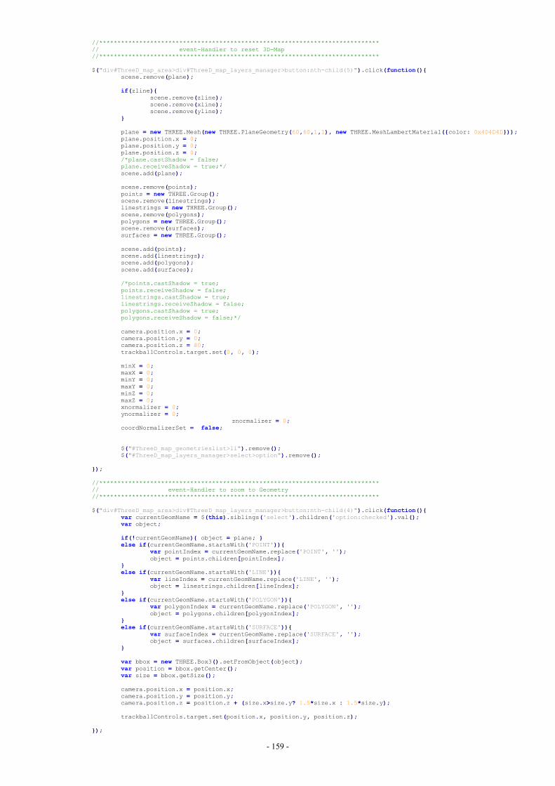
- 159 -
//*****************************************************************************// event-Handler to reset 3D-Map//*****************************************************************************
$("div#ThreeD_map_area>div#ThreeD_map_layers_manager>button:nth-child(5)").click(function(){scene.remove(plane);
if(zline){scene.remove(zline);scene.remove(xline);scene.remove(yline);
}
plane = new THREE.Mesh(new THREE.PlaneGeometry(60,60,1,1), new THREE.MeshLambertMaterial({color: 0x4D4D4D}));plane.position.x = 0;plane.position.y = 0;plane.position.z = 0;/*plane.castShadow = false;plane.receiveShadow = true;*/scene.add(plane);
scene.remove(points);points = new THREE.Group();scene.remove(linestrings);linestrings = new THREE.Group();scene.remove(polygons);polygons = new THREE.Group();scene.remove(surfaces);surfaces = new THREE.Group();
scene.add(points);scene.add(linestrings);scene.add(polygons);scene.add(surfaces);
/*points.castShadow = true;points.receiveShadow = false;linestrings.castShadow = true;linestrings.receiveShadow = false;polygons.castShadow = true;polygons.receiveShadow = false;*/
camera.position.x = 0;camera.position.y = 0;camera.position.z = 80;trackballControls.target.set(0, 0, 0);
minX = 0;maxX = 0;minY = 0;maxY = 0;minZ = 0;maxZ = 0;xnormalizer = 0;ynormalizer = 0;
znormalizer = 0;coordNormalizerSet = false;
$("#ThreeD_map_geometrieslist>li").remove();$("#ThreeD_map_layers_manager>select>option").remove();
});
//*****************************************************************************// event-Handler to zoom to Geometry//*****************************************************************************
$("div#ThreeD_map_area>div#ThreeD_map_layers_manager>button:nth-child(4)").click(function(){var currentGeomName = $(this).siblings('select').children('option:checked').val();var object;
if(!currentGeomName){ object = plane; }else if(currentGeomName.startsWith('POINT')){
var pointIndex = currentGeomName.replace('POINT', '');object = points.children[pointIndex];
}else if(currentGeomName.startsWith('LINE')){
var lineIndex = currentGeomName.replace('LINE', '');object = linestrings.children[lineIndex];
}else if(currentGeomName.startsWith('POLYGON')){
var polygonIndex = currentGeomName.replace('POLYGON', '');object = polygons.children[polygonIndex];
}else if(currentGeomName.startsWith('SURFACE')){
var surfaceIndex = currentGeomName.replace('SURFACE', '');object = surfaces.children[surfaceIndex];
}
var bbox = new THREE.Box3().setFromObject(object);var position = bbox.getCenter();var size = bbox.getSize();
camera.position.x = position.x;camera.position.y = position.y;camera.position.z = position.z + (size.x>size.y? 1.5*size.x : 1.5*size.y);
trackballControls.target.set(position.x, position.y, position.z);
});
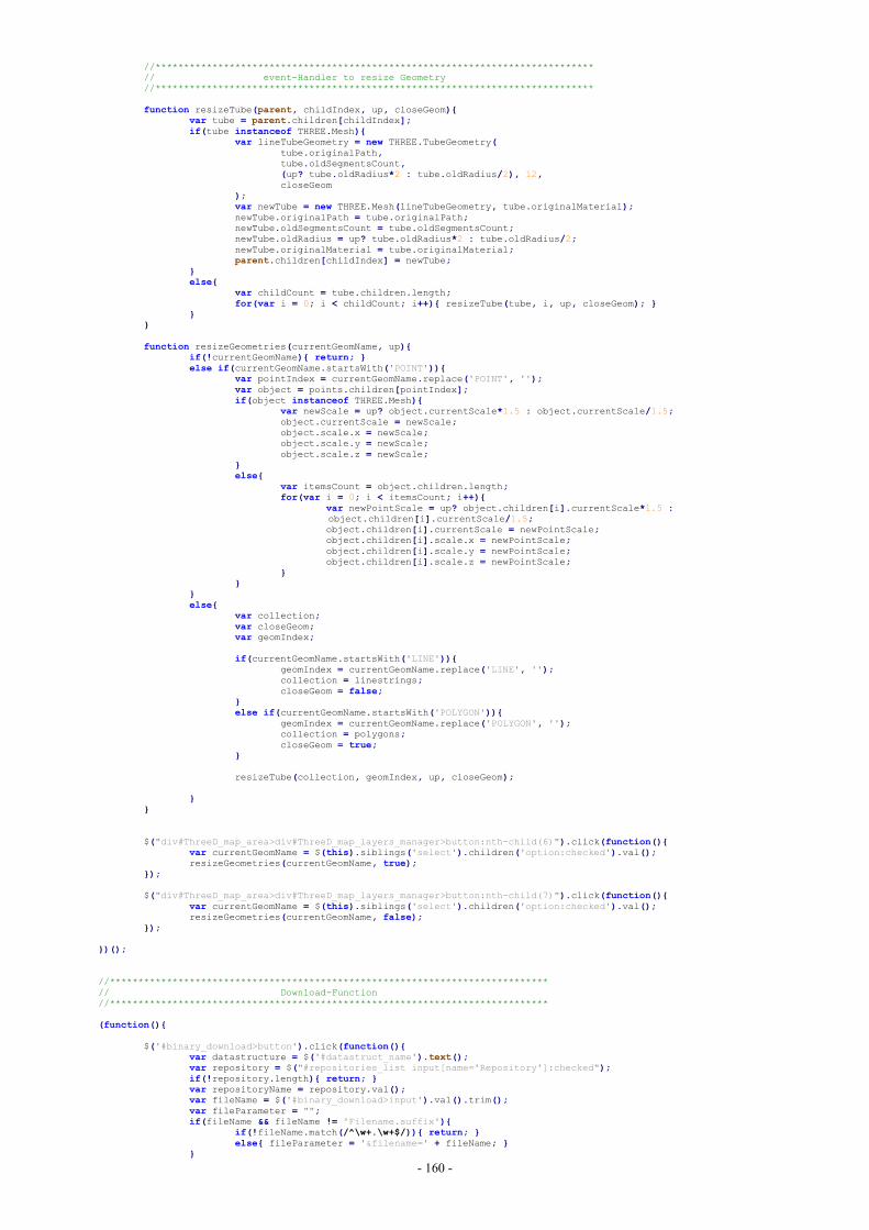
- 160 -
//*****************************************************************************// event-Handler to resize Geometry//*****************************************************************************
function resizeTube(parent, childIndex, up, closeGeom){var tube = parent.children[childIndex];if(tube instanceof THREE.Mesh){
var lineTubeGeometry = new THREE.TubeGeometry(tube.originalPath,tube.oldSegmentsCount,(up? tube.oldRadius*2 : tube.oldRadius/2), 12,closeGeom
);var newTube = new THREE.Mesh(lineTubeGeometry, tube.originalMaterial);newTube.originalPath = tube.originalPath;newTube.oldSegmentsCount = tube.oldSegmentsCount;newTube.oldRadius = up? tube.oldRadius*2 : tube.oldRadius/2;newTube.originalMaterial = tube.originalMaterial;parent.children[childIndex] = newTube;
}else{
var childCount = tube.children.length;for(var i = 0; i < childCount; i++){ resizeTube(tube, i, up, closeGeom); }
}}
function resizeGeometries(currentGeomName, up){if(!currentGeomName){ return; }else if(currentGeomName.startsWith('POINT')){
var pointIndex = currentGeomName.replace('POINT', '');var object = points.children[pointIndex];if(object instanceof THREE.Mesh){
var newScale = up? object.currentScale*1.5 : object.currentScale/1.5;object.currentScale = newScale;object.scale.x = newScale;object.scale.y = newScale;object.scale.z = newScale;
}else{
var itemsCount = object.children.length;for(var i = 0; i < itemsCount; i++){
var newPointScale = up? object.children[i].currentScale*1.5 :object.children[i].currentScale/1.5;object.children[i].currentScale = newPointScale;object.children[i].scale.x = newPointScale;object.children[i].scale.y = newPointScale;object.children[i].scale.z = newPointScale;
}}
}else{
var collection;var closeGeom;var geomIndex;
if(currentGeomName.startsWith('LINE')){geomIndex = currentGeomName.replace('LINE', '');collection = linestrings;closeGeom = false;
}else if(currentGeomName.startsWith('POLYGON')){
geomIndex = currentGeomName.replace('POLYGON', '');collection = polygons;closeGeom = true;
}
resizeTube(collection, geomIndex, up, closeGeom);
}}
$("div#ThreeD_map_area>div#ThreeD_map_layers_manager>button:nth-child(6)").click(function(){var currentGeomName = $(this).siblings('select').children('option:checked').val();resizeGeometries(currentGeomName, true);
});
$("div#ThreeD_map_area>div#ThreeD_map_layers_manager>button:nth-child(7)").click(function(){var currentGeomName = $(this).siblings('select').children('option:checked').val();resizeGeometries(currentGeomName, false);
});
})();
//*****************************************************************************// Download-Function//*****************************************************************************
(function(){
$('#binary_download>button').click(function(){var datastructure = $('#datastruct_name').text();var repository = $("#repositories_list input[name='Repository']:checked");if(!repository.length){ return; }var repositoryName = repository.val();var fileName = $('#binary_download>input').val().trim();var fileParameter = "";if(fileName && fileName != 'Filename.suffix'){
if(!fileName.match(/^\w+.\w+$/)){ return; }else{ fileParameter = '&filename=' + fileName; }
}

- 161 -
window.open("http://" + $(window.location).attr('hostname') + "/GetFile.php?datastructure=" + datastructure +"&repositoryname=" + repositoryName + fileParameter, '_blank');
});
$('#binary_download>input').on('input', function(){if($('#binary_download>input').val().trim()){
$('#binary_download>button').text('get File');}else{ $('#binary_download>button').text('get Repository'); }
});
})();
});
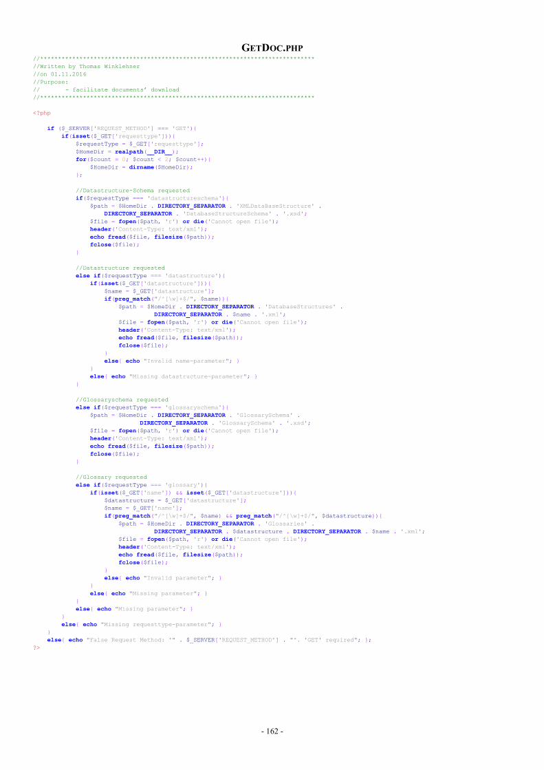
- 162 -
GETDOC.PHP//*****************************************************************************//Written by Thomas Winklehner//on 01.11.2016//Purpose:// - facilitate documents’ download//*****************************************************************************
<?php
if ($_SERVER['REQUEST_METHOD'] === 'GET'){if(isset($_GET['requesttype'])){
$requestType = $_GET['requesttype'];$HomeDir = realpath(__DIR__);for($count = 0; $count < 2; $count++){
$HomeDir = dirname($HomeDir);};
//Datastructure-Schema requestedif($requestType === 'datastructureschema'){
$path = $HomeDir . DIRECTORY_SEPARATOR . 'XMLDataBaseStructure' .DIRECTORY_SEPARATOR . 'DatabaseStructureSchema' . '.xsd';
$file = fopen($path, 'r') or die('Cannot open file');header('Content-Type: text/xml');echo fread($file, filesize($path));fclose($file);
}
//Datastructure requestedelse if($requestType === 'datastructure'){
if(isset($_GET['datastructure'])){$name = $_GET['datastructure'];if(preg_match("/^[\w]+$/", $name)){
$path = $HomeDir . DIRECTORY_SEPARATOR . 'DatabaseStructures' .DIRECTORY_SEPARATOR . $name . '.xml';
$file = fopen($path, 'r') or die('Cannot open file');header('Content-Type: text/xml');echo fread($file, filesize($path));fclose($file);
}else{ echo "Invalid name-parameter"; }
}else{ echo "Missing datastructure-parameter"; }
}
//Glossaryschema requestedelse if($requestType === 'glossaryschema'){
$path = $HomeDir . DIRECTORY_SEPARATOR . 'GlossarySchema' .DIRECTORY_SEPARATOR . 'GlossarySchema' . '.xsd';
$file = fopen($path, 'r') or die('Cannot open file');header('Content-Type: text/xml');echo fread($file, filesize($path));fclose($file);
}
//Glossary requestedelse if($requestType === 'glossary'){
if(isset($_GET['name']) && isset($_GET['datastructure'])){$datastructure = $_GET['datastructure'];$name = $_GET['name'];if(preg_match("/^[\w]+$/", $name) && preg_match("/^[\w]+$/", $datastructure)){
$path = $HomeDir . DIRECTORY_SEPARATOR . 'Glossaries' .DIRECTORY_SEPARATOR . $datastructure . DIRECTORY_SEPARATOR . $name . '.xml';
$file = fopen($path, 'r') or die('Cannot open file');header('Content-Type: text/xml');echo fread($file, filesize($path));fclose($file);
}else{ echo "Invalid parameter"; }
}else{ echo "Missing parameter"; }
}else{ echo "Missing parameter"; }
}else{ echo "Missing requesttype-parameter"; }
}else{ echo "False Request Method: '" . $_SERVER['REQUEST_METHOD'] . "'. 'GET' required"; };
?>
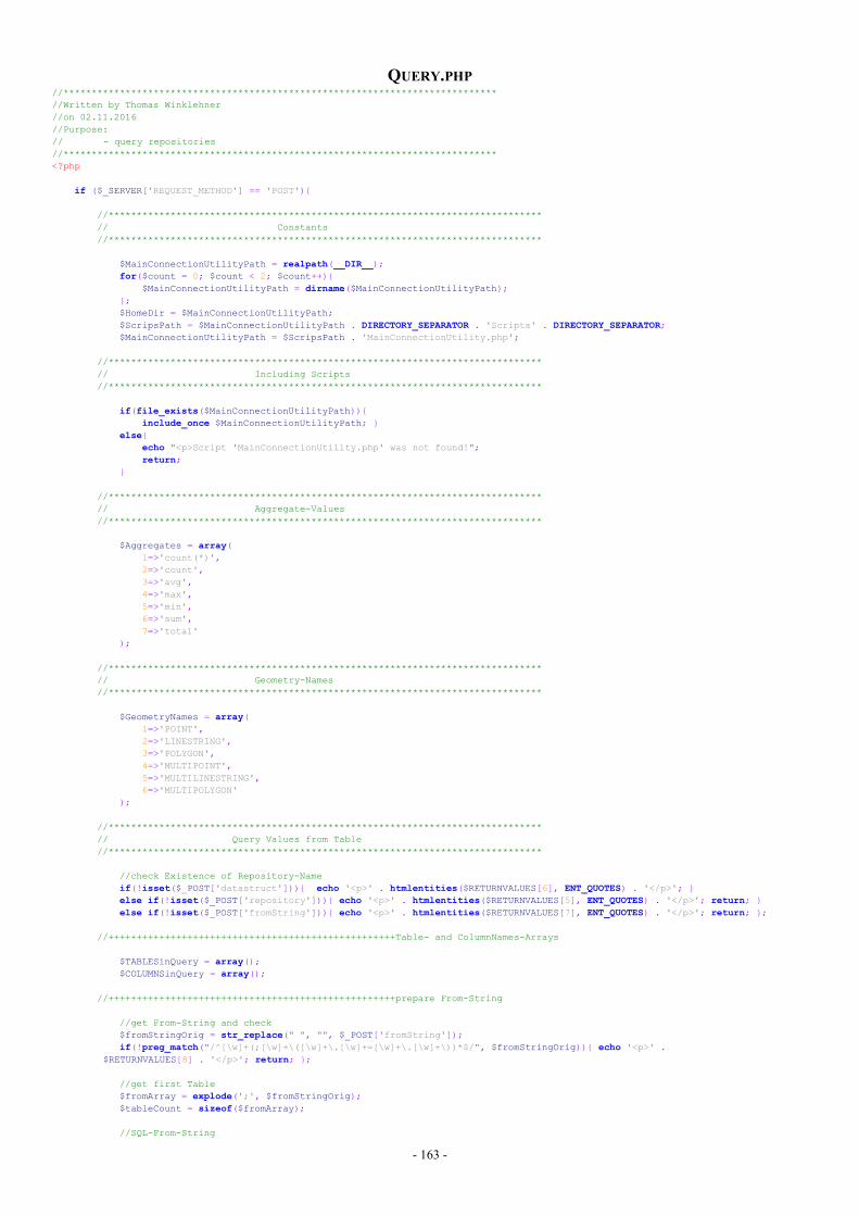
- 163 -
QUERY.PHP//*****************************************************************************//Written by Thomas Winklehner//on 02.11.2016//Purpose:// - query repositories//*****************************************************************************<?php
if ($_SERVER['REQUEST_METHOD'] == 'POST'){
//*****************************************************************************// Constants//*****************************************************************************
$MainConnectionUtilityPath = realpath(__DIR__);for($count = 0; $count < 2; $count++){
$MainConnectionUtilityPath = dirname($MainConnectionUtilityPath);};$HomeDir = $MainConnectionUtilityPath;$ScripsPath = $MainConnectionUtilityPath . DIRECTORY_SEPARATOR . 'Scripts' . DIRECTORY_SEPARATOR;$MainConnectionUtilityPath = $ScripsPath . 'MainConnectionUtility.php';
//*****************************************************************************// Including Scripts//*****************************************************************************
if(file_exists($MainConnectionUtilityPath)){include_once $MainConnectionUtilityPath; }
else{echo "<p>Script 'MainConnectionUtility.php' was not found!";return;
}
//*****************************************************************************// Aggregate-Values//*****************************************************************************
$Aggregates = array(1=>'count(*)',2=>'count',3=>'avg',4=>'max',5=>'min',6=>'sum',7=>'total'
);
//*****************************************************************************// Geometry-Names//*****************************************************************************
$GeometryNames = array(1=>'POINT',2=>'LINESTRING',3=>'POLYGON',4=>'MULTIPOINT',5=>'MULTILINESTRING',6=>'MULTIPOLYGON'
);
//*****************************************************************************// Query Values from Table//*****************************************************************************
//check Existence of Repository-Nameif(!isset($_POST['datastruct'])){ echo '<p>' . htmlentities($RETURNVALUES[6], ENT_QUOTES) . '</p>'; }else if(!isset($_POST['repository'])){ echo '<p>' . htmlentities($RETURNVALUES[5], ENT_QUOTES) . '</p>'; return; }else if(!isset($_POST['fromString'])){ echo '<p>' . htmlentities($RETURNVALUES[7], ENT_QUOTES) . '</p>'; return; };
//+++++++++++++++++++++++++++++++++++++++++++++++++++Table- and ColumnNames-Arrays
$TABLESinQuery = array();$COLUMNSinQuery = array();
//+++++++++++++++++++++++++++++++++++++++++++++++++++prepare From-String
//get From-String and check$fromStringOrig = str_replace(" ", "", $_POST['fromString']);if(!preg_match("/^[\w]+(;[\w]+\([\w]+\.[\w]+=[\w]+\.[\w]+\))*$/", $fromStringOrig)){ echo '<p>' .
$RETURNVALUES[8] . '</p>'; return; };
//get first Table$fromArray = explode(';', $fromStringOrig);$tableCount = sizeof($fromArray);
//SQL-From-String
- 164 -
$sqlFromString = " FROM " . $fromArray[0];$TABLESinQuery[] = $fromArray[0];//store Table in Tables-Array
//loop through the other Tables and append Statements to From-Stringfor($i= 1; $i < $tableCount; $i++){
$tableString = $fromArray[$i];$tableValues = explode('(', $tableString);$tablename = $tableValues[0];$joinedColumns = explode(')', $tableValues[1])[0];$TABLESinQuery[] = $tablename;//store Table in Tables-Array$sqlFromString .= " JOIN " . $tablename . " ON (" . $tableValues[1];$singleJoinedColumns = explode('=', $joinedColumns);$COLUMNSinQuery[] = $singleJoinedColumns[0];//store Column in Columns-Array$COLUMNSinQuery[] = $singleJoinedColumns[1];//store Column in Columns-Array
};
//+++++++++++++++++++++++++++++++++++++++++++++++++++prepare Select-Columns
$spatialColumns = array();$spatialColumnFound = false;
$sqlSelectString = "SELECT ";$aggregateSet = false;if(!isset($_POST['selectedColumnsString'])){ echo "<p>" . $RETURNVALUES[9] . "</p>"; return; }else{
$selectStringOrig = str_replace(" ", "", $_POST['selectedColumnsString']);if(!preg_match("/^[\w]+\.[\w]+(;[\w]+\.[\w]+)*$/", $selectStringOrig)){
echo "<p>" . $RETURNVALUES[10] . "</p>"; return;}else{
$aggregateString = str_replace(" ", "", $_POST['aggregate']);if(empty($aggregateString) || !in_array($aggregateString, $Aggregates)){
$selectArray = $fromArray = explode(';', $selectStringOrig);$columnName = $selectArray[0];$sqlSelectString .= $columnName;$COLUMNSinQuery[] = $columnName;//store Column in Columns-Array$columnCount = sizeof($selectArray);if(stripos($columnName, '_GML_') !== false){
$spatialColumns[] = " class='gml_lit'";$spatialColumnFound = true; }
else if(stripos($columnName, '_WKT_') !== false){$spatialColumns[] = " class='wkt_lit'"; $spatialColumnFound = true; }
else{ $spatialColumns[] = "";};
for($i= 1; $i < $columnCount; $i++){$otherColName = $selectArray[$i];$COLUMNSinQuery[] = $otherColName;//store Column in Columns-Arrayif(stripos($otherColName, '_GML_') !== false){
$spatialColumns[] = " class='gml_lit'";$spatialColumnFound = true; }
else if(stripos($otherColName, '_WKT_') !== false){$spatialColumns[] = " class='wkt_lit'"; $spatialColumnFound = true; }
else{ $spatialColumns[] = "";};$sqlSelectString .= ", " . $selectArray[$i];
};}else{
$firstColumn = explode(';', $selectStringOrig)[0];$COLUMNSinQuery[] = $firstColumn;//store Column in Columns-Array$sqlSelectString .= $aggregateString . "(" . $firstColumn . ")"; $aggregateSet = true;
};};
};
//+++++++++++++++++++++++++++++++++++++++++++++++++++prepare GroupBy-String
$sqlGroupByString = "";if($aggregateSet){
if(isset($_POST['groupByString'])){$groupByStringOrig = str_replace(" ", "", $_POST['groupByString']);if(preg_match("/^[\w]+\.[\w]+(;[\w]+\.[\w]+)*$/", $groupByStringOrig)){
$groupByValues = explode(';', $groupByStringOrig);$sqlGroupByString .= " GROUP BY " . $groupByValues[0];$COLUMNSinQuery[] = $groupByValues[0];//store Column in Columns-Array$groupByCount = sizeof($groupByValues);for($i= 1; $i < $groupByCount; $i++){
$COLUMNSinQuery[] = $groupByValues[$i];//store Column in Columns-Array$sqlGroupByString .= ", " . $groupByValues[$i];
};};
};};
//+++++++++++++++++++++++++++++++++++++++++++++++++++prepare OrderBy-String
$sqlOrderByString = "";if(isset($_POST['orderString'])){
$oderByStringOrig = str_replace(" ", "", $_POST['orderString']);if(preg_match("/^[\w]+\.[\w]+;(ASC|DESC)(;[\w]+\.[\w]+;(ASC|DESC))*$/", $oderByStringOrig)){
- 165 -
$oderByValues = explode(';', $oderByStringOrig);$sqlOrderByString .= " ORDER BY " . $oderByValues[0] . " " . $oderByValues[1];$COLUMNSinQuery[] = $oderByValues[0];//store Column in Columns-Array$oderByCount = sizeof($oderByValues);for($i=2; $i < $oderByCount; $i=$i+2){
$COLUMNSinQuery[] = $oderByValues[$i];//store Column in Columns-Array$sqlOrderByString .= ", " . $oderByValues[$i] . " " . $oderByValues[$i+1];
};};
};
//+++++++++++++++++++++++++++++++++++++++++++++++++++prepare conditions-String
$sqlWhereString = "";if(isset($_POST['conditionsString'])){
$conditionsStringOrig = str_replace(" ", "", $_POST['conditionsString']);if(preg_match("/^[\w]+\.[\w]+;(([<>=!]{1,2};[[:digit:]]+(\.[[:digit:]]+)*)|((=|!=|LIKE);'[^']*'))(;[\w]+\.[\w]
+;(([<>=!]{1,2};[[:digit:]]+(\.[[:digit:]]+)*)|((=|!=|LIKE);'[^']*')))*$/", $conditionsStringOrig)){$conditionsValues = explode(';', $conditionsStringOrig);$operator = $conditionsValues[1];if($operator === "LIKE"){ $operator = " " . $operator . " "; };$sqlWhereString .= " WHERE " . $conditionsValues[0] . $operator . $conditionsValues[2];$COLUMNSinQuery[] = $conditionsValues[0];//store Column in Columns-Array$conditionsCount = sizeof($conditionsValues);for($i= 3; $i < $conditionsCount; $i = $i+3){
$COLUMNSinQuery[] = $conditionsValues[$i];//store Column in Columns-Array$localOperator = $conditionsValues[$i+1];if($localOperator === "LIKE"){ $localOperator = " " . $localOperator . " "; };$sqlWhereString .= " AND " . $conditionsValues[$i] . $localOperator . $conditionsValues[$i+2];
};};
};
$limit = " LIMIT ";if(isset($_POST['sqlLimit']) && preg_match("/^[[:digit:]]{1,6}$/", $_POST['sqlLimit'])){ $limit .= $_POST['sqlLimit']; }else{ $limit .= '1000'; }
$offset = " OFFSET ";if(isset($_POST['sqlOffset']) && preg_match("/^[[:digit:]]{1,6}$/", $_POST['sqlOffset'])){ $offset .=
$_POST['sqlOffset']; }else{ $offset .= '0'; }
$sql = $sqlSelectString . $sqlFromString . $sqlWhereString . $sqlGroupByString . $sqlOrderByString . $limit . $offset;
echo "<p>Query: " . $sql . "<p>";
//+++++++++++++++++++++++++++++++++++++++++++++++++++start Connection
//*****************************************************************************// getting RepositoryPath//*****************************************************************************
$datastructure = str_replace(" ", "", $_POST['datastruct']);$datastructure = str_replace("'", "", $datastructure);
$repository = str_replace(" ", "", $_POST['repository']);$repository = str_replace("'", "", $repository);
$repositoryPath = getRepositoryPath($datastructure, $repository);
if(is_integer($repositoryPath)){echo "<p>" . $RETURNVALUES[$repositoryPath] . "</p>";return;
}else if(!file_exists($repositoryPath)){
echo "<p>Repository " . $repository . " not found!</p>";return;
};
//*****************************************************************************// Establish Repository-Connection//*****************************************************************************
$dbHandle = new SQLiteDBConn($repositoryPath);if(isset($dbHandle)){
$TableColumns = array();
//check Columns$TABLESinQueryCount = sizeof($TABLESinQuery);for($i = 0; $i < $TABLESinQueryCount; $i++){
$TableColumnsResult = $dbHandle->query("Pragma table_info(" . $TABLESinQuery[$i] . ")");$row = $TableColumnsResult->fetchArray(SQLITE3_ASSOC);while($row !== false){
$TableColumns[$TABLESinQuery[$i] . "." . $row['name']] = $row['type'];$row = $TableColumnsResult->fetchArray(SQLITE3_ASSOC);
};$TableColumnsResult->finalize();
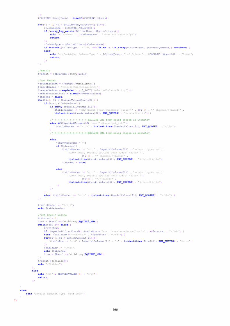
- 166 -
};$COLUMNSinQueryCount = sizeof($COLUMNSinQuery);
for($i = 0; $i < $COLUMNSinQueryCount; $i++){$ColumnName = $COLUMNSinQuery[$i];if(!array_key_exists($ColumnName, $TableColumns)){
echo "<p>Column " . $ColumnName . " does not exist!</p>";return;
};$ColumnType = $TableColumns[$ColumnName];if(stripos($ColumnType, 'BLOB') === false && !in_array($ColumnType, $GeometryNames)){ continue; }else{
echo "<p>Forbidden Column-Type " . $ColumnType . " of Column " . $COLUMNSinQuery[$i] . "!</p>";return;
};};
//Result$Result = $dbHandle->query($sql);
//get Header$columnsCount = $Result->numColumns();$tableHeader = "<table><tr><th>row</th>";$headerValues = explode(';', $_POST['selectedColumnsString']);$headerValuesCount = sizeof($headerValues);$checked = false;for($i=0; $i < $headerValuesCount;$i++){
if($spatialColumnFound){if(empty($spatialColumns[$i])){
$tableHeader .= "<th><input type='checkbox' value='" . ($i+2) . "' checked/><label>" .htmlentities($headerValues[$i], ENT_QUOTES) . "</label></th>"; }
//+++++++++++++++++++++++EXCLUDE GML from being chosen as Geometryelse if($spatialColumns[$i] === " class='gml_lit'"){
$tableHeader .= "<th>" . htmlentities($headerValues[$i], ENT_QUOTES) . "</th>";}//+++++++++++++++++++++++EXCLUDE GML from being chosen as Geometry
else{$checkedString = "";if(!$checked){
$tableHeader .= "<th " . $spatialColumns[$i] . "><input type='radio'name='query_results_spatial_cols_radio' value='" .
($i+2) . "' checked/><label>" .htmlentities($headerValues[$i], ENT_QUOTES) . "</label></th>";
$checked = true;}else{
$tableHeader .= "<th " . $spatialColumns[$i] . "><input type='radio'name='query_results_spatial_cols_radio' value='" .
($i+2) . "'/><label>" .htmlentities($headerValues[$i], ENT_QUOTES) . "</label></th>";
};};
}else{ $tableHeader .= "<th>" . htmlentities($headerValues[$i], ENT_QUOTES) . "</th>"; }
};
$tableHeader .= "</tr>";echo $tableHeader;
//get Result-Values$counter = 0;$row = $Result->fetchArray(SQLITE3_NUM);while($row !== false){
$tableRow;if( $spatialColumnFound){ $tableRow = "<tr class='unselected'><td>" . ++$counter . "</td>"; }else{ $tableRow = "<tr><td>" . ++$counter . "</td>"; }for($i=0; $i < $columnsCount;$i++){
$tableRow .= "<td" . $spatialColumns[$i] . ">" . htmlentities($row[$i], ENT_QUOTES) . "</td>";};$tableRow .= "</tr>";echo $tableRow;$row = $Result->fetchArray(SQLITE3_NUM);
};$Result->finalize();echo "</table>";
}else{
echo "<p>" . $RETURNVALUES[4] . "</p>";return;
};
}else{
echo "Invalid Request Type. Use: POST";}
?>
- 167 -
GETFILE.PHP//*****************************************************************************//Written by Thomas Winklehner//on 03.11.2016//Purpose:// - facilitate files’ download//*****************************************************************************<?php
if ($_SERVER['REQUEST_METHOD'] === 'GET'){if(isset($_GET['datastructure']) && isset($_GET['repositoryname'])){
$HomeDir = realpath(__DIR__);for($count = 0; $count < 2; $count++){
$HomeDir = dirname($HomeDir);};
//get Parameters$datastructure = $_GET['datastructure'];$repositoryname = $_GET['repositoryname'];$fileName = "";
//check Parametersif(!preg_match("/^[\w]+$/", $datastructure)){
echo "invalid datastructure-Parameter";return; }
else if(!preg_match("/^[\w]+$/", $repositoryname)){echo "invalid repository-Parameter";return;
};
//get File-Directory$filepath = $HomeDir . DIRECTORY_SEPARATOR . 'Repositories' . DIRECTORY_SEPARATOR . $datastructure . DIRECTORY_SEPARATOR .
$repositoryname;
//get Filenameif(isset($_GET['filename'])){
$fileName = $_GET['filename'];$filepath .= DIRECTORY_SEPARATOR . $fileName; }
else{$fileName = $repositoryname . '.sqlite';$filepath .= '.sqlite';
};
//check-FileNameif(!preg_match("/^[\w]+.[\w]+$/", $datastructure)){
echo "invalid datastructure-Parameter";return;
}
if(file_exists($filepath) && is_file($filepath)){
//get file-size$size = filesize($filepath);
if($size > 10000000000){echo "File too big. Max size: 9 GB";return;
};
//no time-out for scriptset_time_limit(0);
//set Headersheader('Content-Type: application/octet-stream');header('Content-Length: ' . $size);header('Content-Disposition: attachment; filename="' . $fileName . '"');header('Content-Transfer-Encoding: binary');header('Content-Description: File Transfer');
//stop bufferingob_clean();ob_implicit_flush(false);ob_end_clean();readfile($filepath);
}else{ echo "Download-failed. File not found or not-readable"; };
}else{ echo "Download-failed. Missing valid Parameters"; };
};?>