Embed Size (px)
Citation preview
Part 9 Development codes9.1 Preliminary(1) Development codes are codes for assessment where identified as an applicable code in Part 5.(2) Statewide codes are included in all Queensland planning schemes.(3) Use codes and other development codes are specific to each planning scheme area.(4) The following are the statewide codes for the planning scheme:
(a) Community residence code(b) Forestry for wood production code(c) Reconfiguring a lot (subdividing one lot into two lots) and associated operational works code.
(5) The following are the use codes for the planning scheme:(a) Advertising devices(b) Development design(c) Extractive industry(d) Home based business(e) Landscaping(f) Operational works(g) Reconfiguring a lot(h) Telecommunications facility use
(6) The following are the other development codes for the planning scheme:(a) State Development Areas – State Development and Public Works Organisation Act 1971(b) Port of Gladstone and Port Alma (part)(c) Priority Development Areas – Economic Development Act 2012.
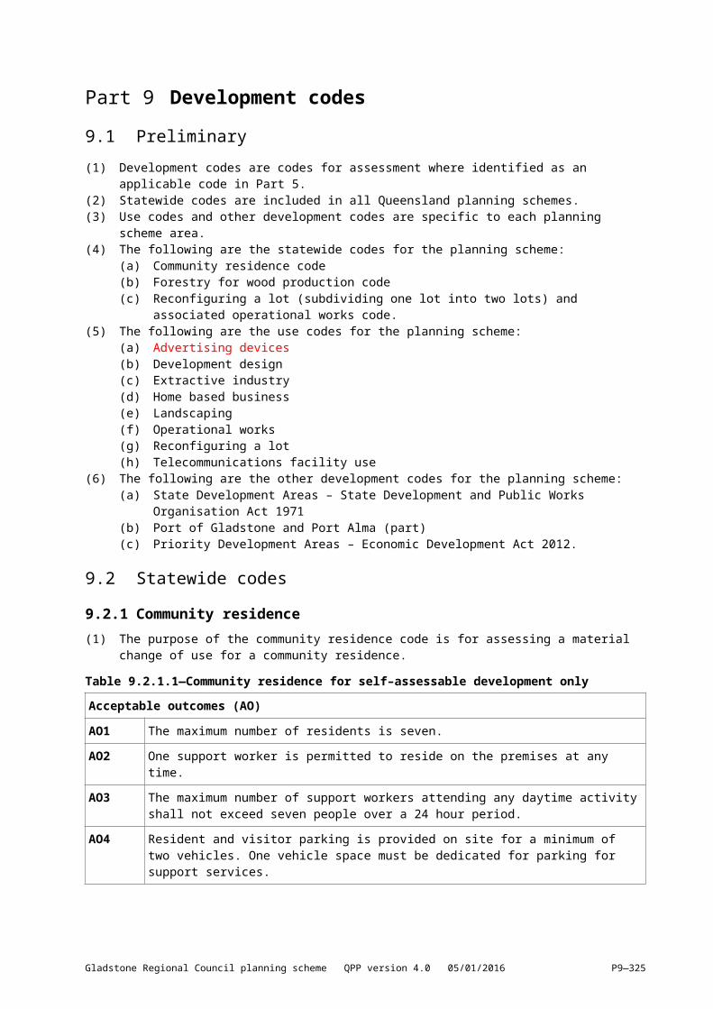
9.2 Statewide codes9.2.1 Community residence(1) The purpose of the community residence code is for assessing a material change of use for a
community residence.
Table 9.2.1.1—Community residence for self–assessable development only
Acceptable outcomes (AO)
AO1 The maximum number of residents is seven.
AO2 One support worker is permitted to reside on the premises at any time.
AO3 The maximum number of support workers attending any daytime activity shall not exceed seven people over a 24 hour period.
AO4 Resident and visitor parking is provided on site for a minimum of two vehicles. One vehicle space must be dedicated for parking for support services.
Gladstone Regional Council planning scheme QPP version 4.0 05/01/2016 P9—325
9.2.2 Forestry for wood production9.2.2.1 ApplicationThis code applies to assessing a material change of use for development involving cropping (where involving forestry for wood production) in the rural zone.
9.2.2.2 Purpose(1) The purpose of the code is to ensure forestry for wood production is assessed with equal regard to
other forms of cropping, to guarantee long–term harvest and minimise impacts.(2) The purpose of the code will be achieved through the following overall outcomes:
(a) the use is appropriately located and setback from areas of environmental interest and existing infrastructure
(b) the impacts on adjoining land uses are minimised(c) the risk of fire is minimised(d) expected harvest cycles, volumes, timescales and haulage routes, plus proposed wildfire
management and the location of supportive infrastructure are known by the local government, where development is assessable.
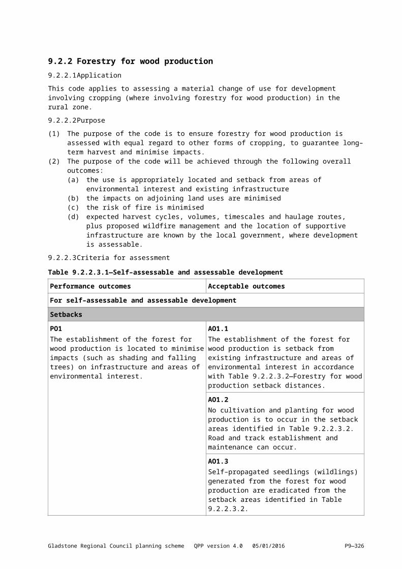
9.2.2.3 Criteria for assessment Table 9.2.2.3.1—Self–assessable and assessable development
Performance outcomes Acceptable outcomes
For self–assessable and assessable developmentSetbacksPO1The establishment of the forest for wood production is located to minimise impacts (such as shading and falling trees) on infrastructure and areas of environmental interest.
AO1.1The establishment of the forest for wood production is setback from existing infrastructure and areas of environmental interest in accordance with Table 9.2.2.3.2—Forestry for wood production setback distances.
AO1.2No cultivation and planting for wood production is to occur in the setback areas identified in Table 9.2.2.3.2. Road and track establishment and maintenance can occur.
AO1.3Self–propagated seedlings (wildlings) generated from the forest for wood production are eradicated from the setback areas identified in Table 9.2.2.3.2.
Impacts on soil structure, fertility and stabilityPO2The impacts of the forest for wood production on soil structure, fertility and stability are minimised through appropriate management of the site.
AO2.1The establishment and maintenance (including associated tracks and roads) of the forest for wood production utilises one or more of the following methods:(a) mechanical strip cultivation on the contour,
spot cultivation or manual cultivation is used for establishment on slopes greater than 10% and less than 25%
(b) either spot cultivation or manual cultivation is used for establishment on slopes equal to or greater than 25%
(c) tracks and roads are established away from
Gladstone Regional Council planning scheme QPP version 4.0 05/01/2016 P9—326
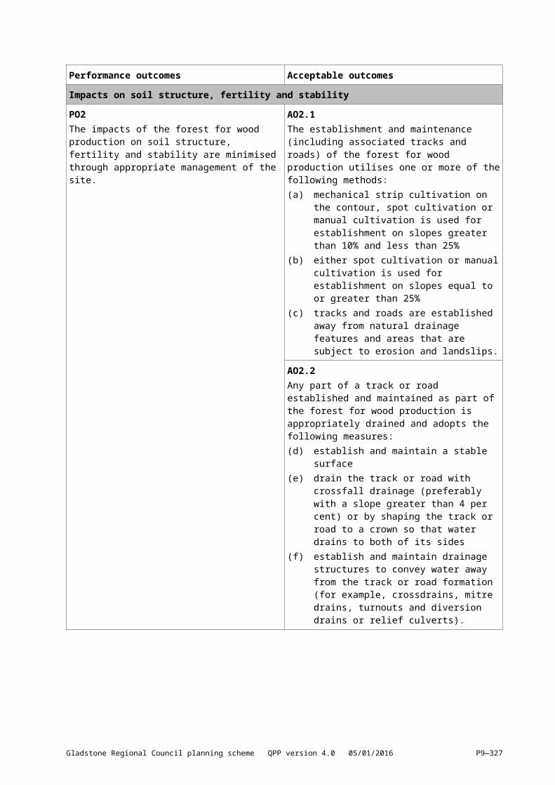
Performance outcomes Acceptable outcomes
natural drainage features and areas that are subject to erosion and landslips.
AO2.2Any part of a track or road established and maintained as part of the forest for wood production is appropriately drained and adopts the following measures:(d) establish and maintain a stable surface(e) drain the track or road with crossfall drainage
(preferably with a slope greater than 4 per cent) or by shaping the track or road to a crown so that water drains to both of its sides
(f) establish and maintain drainage structures to convey water away from the track or road formation (for example, crossdrains, mitre drains, turnouts and diversion drains or relief culverts).
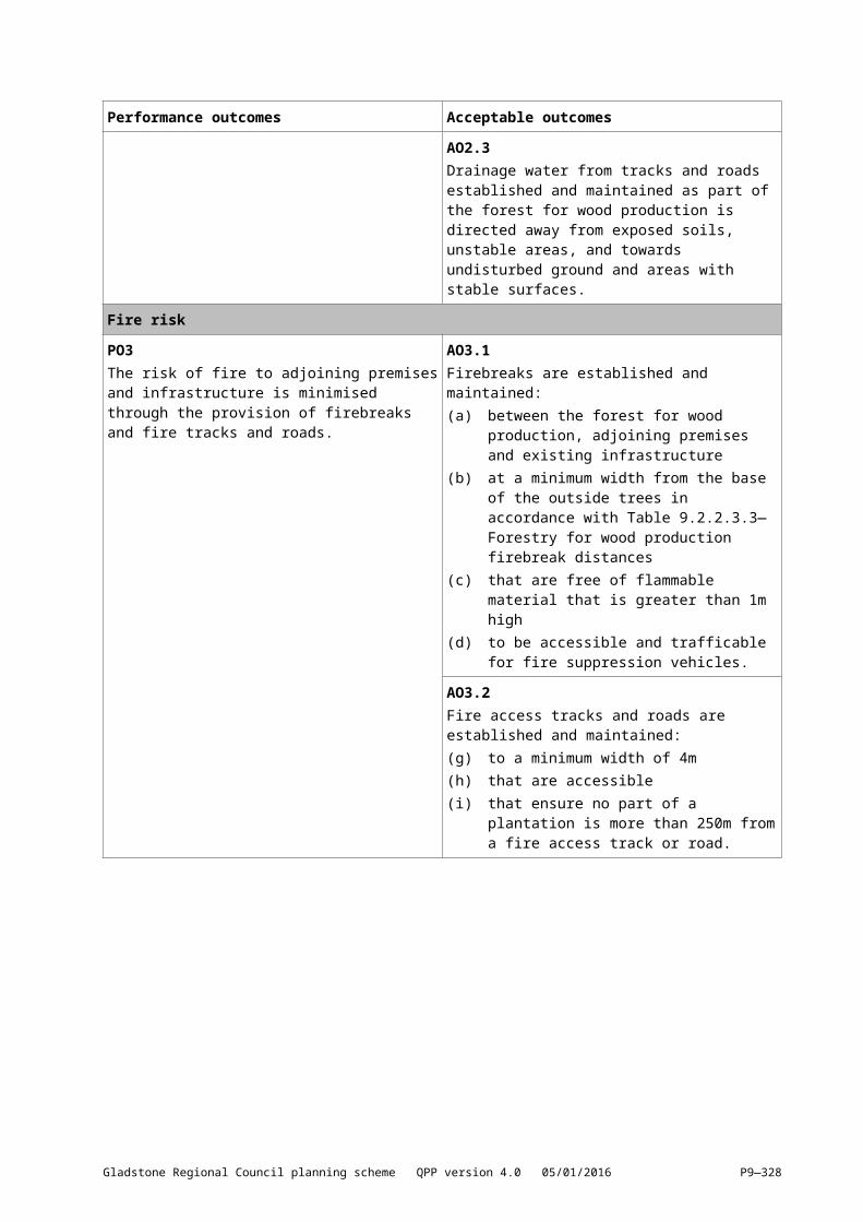
AO2.3Drainage water from tracks and roads established and maintained as part of the forest for wood production is directed away from exposed soils, unstable areas, and towards undisturbed ground and areas with stable surfaces.
Fire riskPO3The risk of fire to adjoining premises and infrastructure is minimised through the provision of firebreaks and fire tracks and roads.
AO3.1Firebreaks are established and maintained:(a) between the forest for wood production,
adjoining premises and existing infrastructure
(b) at a minimum width from the base of the outside trees in accordance with Table 9.2.2.3.3—Forestry for wood production firebreak distances
(c) that are free of flammable material that is greater than 1m high
(d) to be accessible and trafficable for fire suppression vehicles.
AO3.2Fire access tracks and roads are established and maintained:(g) to a minimum width of 4m(h) that are accessible(i) that ensure no part of a plantation is more
than 250m from a fire access track or road.
Gladstone Regional Council planning scheme QPP version 4.0 05/01/2016 P9—327
Performance outcomes Acceptable outcomes
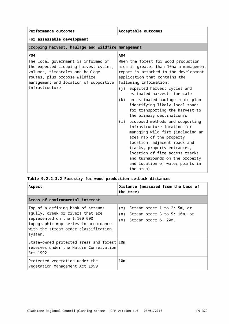
For assessable developmentCropping harvest, haulage and wildfire managementPO4The local government is informed of the expected cropping harvest cycles, volumes, timescales and haulage routes, plus propose wildfire management and location of supportive infrastructure.
AO4When the forest for wood production area is greater than 10ha a management report is attached to the development application that contains the following information:(j) expected harvest cycles and estimated
harvest timescale(k) an estimated haulage route plan identifying
likely local roads for transporting the harvest to the primary destination/s
(l) proposed methods and supporting infrastructure location for managing wild fire (including an area map of the property location, adjacent roads and tracks, property entrances, location of fire access tracks and turnarounds on the property and location of water points in the area).
Table 9.2.2.3.2—Forestry for wood production setback distances
Aspect Distance (measured from the base of the tree)
Areas of environmental interestTop of a defining bank of streams (gully, creek or river) that are represented on the 1:100 000 topographic map series in accordance with the stream order classification system.
(m) Stream order 1 to 2: 5m, or(n) Stream order 3 to 5: 10m, or(o) Stream order 6: 20m.
State–owned protected areas and forest reserves under the Nature Conservation Act 1992.
10m
Protected vegetation under the Vegetation Management Act 1999.
10m
InfrastructureDwellings 100m or such distance that ensures the dwelling is
consistent with the requirements of AS3959–2009 and the National Construction Code.
Machinery sheds 25m or 1.5 times the maximum anticipated height of the tree at harvest, whichever is the greater.
Transmission lines and above–ground pipelines (excluding infrastructure servicing only the farm) not subject to an easement.
25m or 1.5 times the maximum anticipated height of the tree at harvest, whichever is the greater.
Table 9.2.2.3.3—Forestry for wood production firebreak distances
Aspect Distance
FirebreaksForestry for wood production activities less than 40ha.
7m
Forestry for wood production of 40ha to 100ha. 10m
Gladstone Regional Council planning scheme QPP version 4.0 05/01/2016 P9—328
Aspect Distance
Forestry for wood production greater than 100ha. 20m or a 10m break that is free of flammable material that is greater than 1m high followed by a 10m fuel reduction area where forestry for wood production trees are pruned up to a minimum height of 5m, commencing once trees are greater than 10m in height.
Gladstone Regional Council planning scheme QPP version 4.0 05/01/2016 P9—329
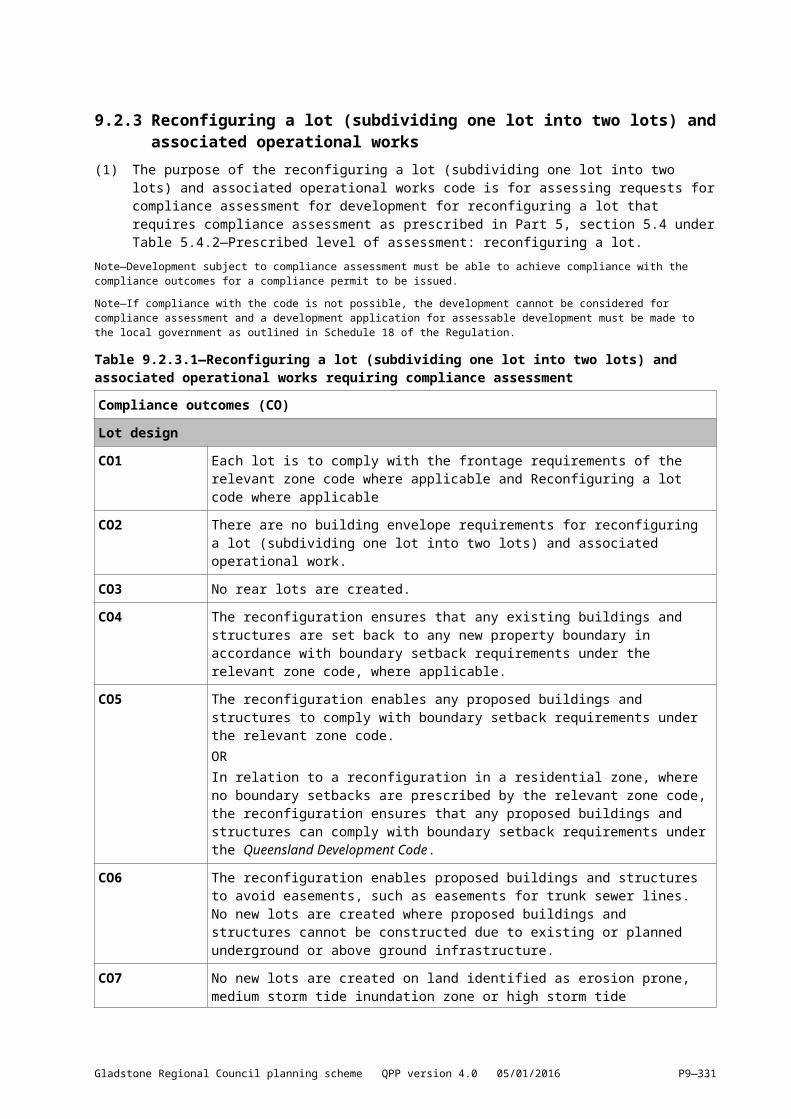
9.2.3 Reconfiguring a lot (subdividing one lot into two lots) and associated operational works
(1) The purpose of the reconfiguring a lot (subdividing one lot into two lots) and associated operational works code is for assessing requests for compliance assessment for development for reconfiguring a lot that requires compliance assessment as prescribed in Part 5, section 5.4 under Table 5.4.2—Prescribed level of assessment: reconfiguring a lot.
Note—Development subject to compliance assessment must be able to achieve compliance with the compliance outcomes for a compliance permit to be issued.
Note—If compliance with the code is not possible, the development cannot be considered for compliance assessment and a development application for assessable development must be made to the local government as outlined in Schedule 18 of the Regulation.
Table 9.2.3.1—Reconfiguring a lot (subdividing one lot into two lots) and associated operational works requiring compliance assessment
Compliance outcomes (CO)
Lot designCO1 Each lot is to comply with the frontage requirements of the relevant zone code where
applicable and Reconfiguring a lot code where applicable
CO2 There are no building envelope requirements for reconfiguring a lot (subdividing one lot into two lots) and associated operational work.
CO3 No rear lots are created.
CO4 The reconfiguration ensures that any existing buildings and structures are set back to any new property boundary in accordance with boundary setback requirements under the relevant zone code, where applicable.
CO5 The reconfiguration enables any proposed buildings and structures to comply with boundary setback requirements under the relevant zone code.ORIn relation to a reconfiguration in a residential zone, where no boundary setbacks are prescribed by the relevant zone code, the reconfiguration ensures that any proposed buildings and structures can comply with boundary setback requirements under the Queensland Development Code.
CO6 The reconfiguration enables proposed buildings and structures to avoid easements, such as easements for trunk sewer lines. No new lots are created where proposed buildings and structures cannot be constructed due to existing or planned underground or above ground infrastructure.
CO7 No new lots are created on land identified as erosion prone, medium storm tide inundation zone or high storm tide inundation zone on the Coastal hazard overlay map. No new lots are created on land identified as a flood hazard area on the Flood hazard overlay map.
CO8 No new lots are created on land identified within a medium, high or very high bushfire hazard area on the Bushfire hazard overlay map.
CO9 No new lots are created where the existing slope of the land is 15% or greater.
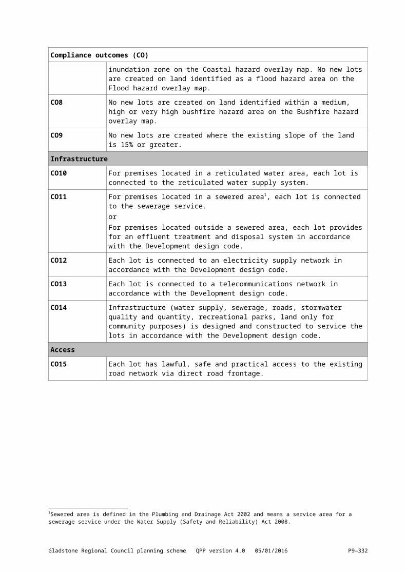
InfrastructureCO10 For premises located in a reticulated water area, each lot is connected to the
reticulated water supply system.
CO11 For premises located in a sewered area1, each lot is connected to the sewerage service.
1Sewered area is defined in the Plumbing and Drainage Act 2002 and means a service area for a sewerage service under the Water Supply (Safety and Reliability) Act 2008.
Gladstone Regional Council planning scheme QPP version 4.0 05/01/2016 P9—330
Compliance outcomes (CO)
orFor premises located outside a sewered area, each lot provides for an effluent treatment and disposal system in accordance with the Development design code.
CO12 Each lot is connected to an electricity supply network in accordance with the Development design code.
CO13 Each lot is connected to a telecommunications network in accordance with the Development design code.
CO14 Infrastructure (water supply, sewerage, roads, stormwater quality and quantity, recreational parks, land only for community purposes) is designed and constructed to service the lots in accordance with the Development design code.
AccessCO15 Each lot has lawful, safe and practical access to the existing road network via direct
road frontage.
CO16 A driveway crossover to each lot is designed and constructed in accordance with the Development design code.
StormwaterCO17 Onsite erosion and the release of sediment or sediment–laden stormwater from the
premises is minimised at all times including during construction and complies with the Development design code.
CO18 Filling or excavation on the premises does not exceed a maximum of 1m vertical change in natural ground level at any point.
CO19 Filling or excavation does not cause ponding on the premises or adjoining land in accordance with the Development design code.
Gladstone Regional Council planning scheme QPP version 4.0 05/01/2016 P9—331
9.3 Use codes9.3.1 Advertising devices 9.3.1.1 ApplicationThis code applies to the assessment of operational work for placing an advertising device on a road corridor or on premises, where the code is identified as applicable in the tables of assessment.
9.3.1.2 Purpose(1) The purpose of the advertising devices code is to:
(a) Facilitate economic activity through the advertising of business, products and services and to provide a communication platform for governments to share information with the community.
(b) .Provide unique and creative static and digital signage that contributes to the character and vibrancy of the setting.
(c)[(b)] Ensure that advertising devices do not adversely affect visual amenity, the character of the local area and public safety.
(d) P revent new advertising devices unreasonably obstructing existing, lawfully installed, advertising devices.
(2) The purpose of the code will be achieved through the following overall outcomes:(a) An advertising device complements, and does not detract from, the desirable characteristics
of the natural and built environment in which the advertising device is exhibited.(b) An advertising device is designed and integrated on the site so as to minimise visual clutter,
particularly along major road corridors.(c) An advertising device does not pose a hazard for pedestrians, cyclists or drivers of motor
vehicles. (d) An advertising device does not unreasonably impede views, sunlight or breezes for residents
on adjoining sites, or create nuisance as a result of noisy, flashing or illuminated devices.
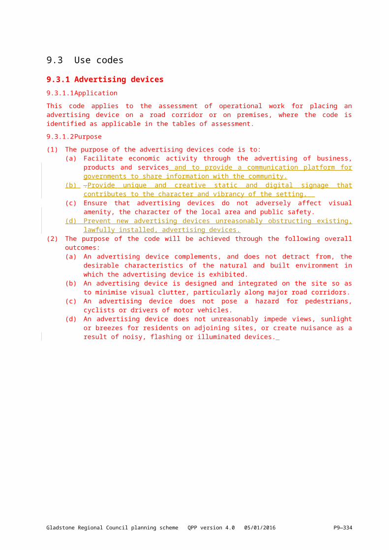
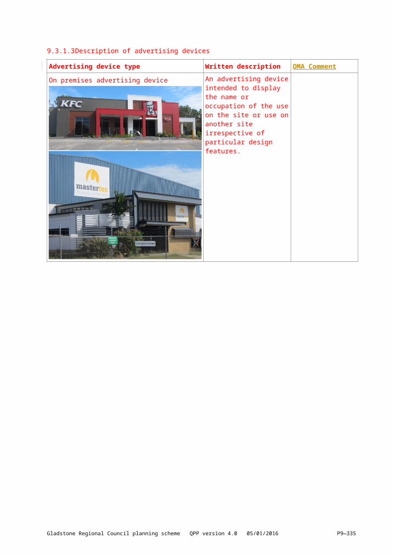
9.3.1.3 Description of advertising devices
Advertising device type Written description OMA Comment
On premises advertising device An advertising device intended to display the name or occupation of the use on the site or use on another site irrespective of particular design features.
Gladstone Regional Council planning scheme QPP version 4.0 05/01/2016 P9—332

Advertising device type Written description OMA Comment
Transport corridor advertising device A free standing or wall or roof mounted advertising device located near or adjacent to a transport corridor for the purpose of advertising to the mass publiccommunity.
Transport corridor advertising devices are also attached to walls and roof-tops ofBuildings.
9.3.1.4 Description of urban and non-urban zones
Urban zone Non-urban zone
Low density residentialLow-medium density residentialMedium density residentialCentreCommunity facilitiesPrincipal centreNeighbourhood centreSport and recreationLow impact industryMedium impact industrySpecial industryMajor tourismMinor tourismMixed useSpecialised centreTownship
Character residentialOpen spaceEnvironmental managementConservationIndustry investigationEmerging communityLimited developmentRuralRural residentialSpecial purpose
Gladstone Regional Council planning scheme QPP version 4.0 05/01/2016 P9—333
Note - Table 9.3.1.4 is only to be used in conjunction with the Advertising devices code and is not to be used for assessment with any other code of the planning scheme.
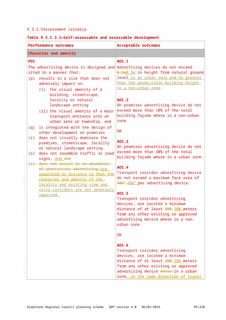
9.3.1.5 Assessment criteriaTable 9.3.1.3.1—Self–assessable and assessable development
Performance outcomes Acceptable outcomes
Character and amenityPO1The advertising device is designed and sited in a manner that:(p) results in a size that does not adversely
impact on:(i) the visual amenity of a building,
streetscape, locality or natural landscape setting
(ii) the visual amenity of a main transport entrance into an urban area or township, and
(q) is integrated with the design of other development on premises
(r) does not visually dominate the premises, streetscape, locality or natural landscape setting
[(s)] does not resemble traffic or road signs, and and
[(t)] does not result in an abundance of unnecessary advertising.are separated by distance so that the character and amenity of the locality and existing view and vista corridors are not adversely impacted.
AO1.1Advertising devices do not exceed 8.5m8.5m in height from natural ground level in an urban zone and no greater than the permissible building height in a non-urban zone.
AO1.2On premises advertising device do not exceed more than 10% of the total building façade where in a non-urban zone.
OR
AO1.3On premises advertising device do not exceed more than 30% of the total building façade where in a urban zone.
AO1.4Transport corridor advertising device do not exceed a maximum face area of 40m2 48m2 per advertising device.
AO1.5Transport corridor advertising devices, are located a minimum distance of at least 800 300 meters from any other existing or approved advertising device where in a non-urban zone.
OR
AO1.6Transport corridor advertising devices, are located a minimum distance of at least 200 100 meters from any other existing or approved advertising device where in a urban zone, in the same direction of travel.
Bus Shelters and Street FurniturePO2The advertising device is compatible with the design of the bus shelter/street furniture and does not impact on the amenity of nearby residents.
AO2.1Advertising sign not to extend above height of bus shelter structure.Luminance of the advertising sign not to impact on local residents.
Gladstone Regional Council planning scheme QPP version 4.0 05/01/2016 P9—334
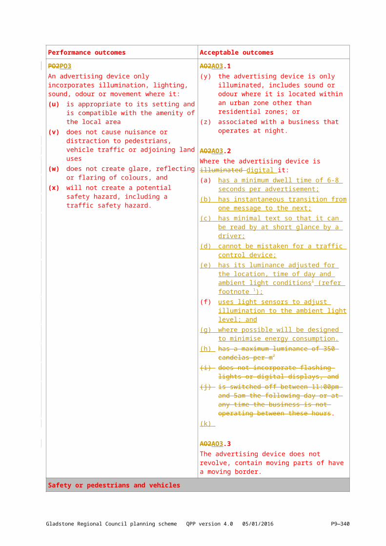
Performance outcomes Acceptable outcomes
PO2PO3An advertising device only incorporates illumination, lighting, sound, odour or movement where it:(s)[(u)] is appropriate to its setting and is
compatible with the amenity of the local area(t)[(v)] does not cause nuisance or distraction to
pedestrians, vehicle traffic or adjoining land uses
(u)[(w)] does not create glare, reflecting or flaring of colours, and
(v)[(x)] will not create a potential safety hazard, including a traffic safety hazard.
AO2AO3.1(w)[(y)] the advertising device is only illuminated,
includes sound or odour where it is located within an urban zone other than residential zones; or
(x)[(z)] associated with a business that operates at night.
AO2AO3.2Where the advertising device is illuminated digital it:(a) has a minimum dwell time of 6-8 seconds
per advertisement;(b) has instantaneous transition from one
message to the next;(c) has minimal text so that it can be read by at
short glance by a driver;(d) cannot be mistaken for a traffic control
device;(e) has its luminance adjusted for the location,
time of day and ambient light conditionsi (refer footnote 1 );
(f)[(b)] uses light sensors to adjust illumination to the ambient light level; and
(g) where possible will be designed to minimise energy consumption.
(h) has a maximum luminance of 350 candelas per m2
[(c)] does not incorporate flashing lights or digital displays, and
[(d)] is switched off between 11:00pm and 5am the following day or at any time the business is not operating between these hours.
(i)
AO2AO3.3The advertising device does not revolve, contain moving parts of have a moving border.
Safety or pedestrians and vehicles
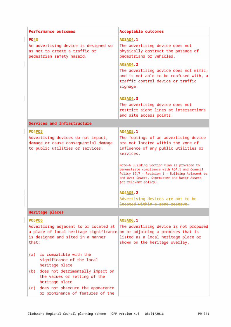
PO43An advertising device is designed so as not to create a traffic or pedestrian safety hazard.
AO3AO4.1The advertising device does not physically obstruct the passage of pedestrians or vehicles.
AO3AO4.2The advertising advice does not mimic, and is not able to be confused with, a traffic control device or traffic signage.
AO3AO4.3The advertising device does not restrict sight lines at intersections and site access points.
Gladstone Regional Council planning scheme QPP version 4.0 05/01/2016 P9—335
Performance outcomes Acceptable outcomes
Services and InfrastructurePO4PO5Advertising devices do not impact, damage or cause consequential damage to public utilities or services.
AO4AO5.1The footings of an advertising device are not located within the zone of influence of any public utilities or services.
Note—A Building Section Plan is provided to demonstrate compliance with AO4.1 and Council Policy 19.7 - Revision 1 - Building Adjacent to and Over Sewers, Stormwater and Water Assets (or relevant policy).
AO4AO5.2Advertising devices are not to be located within a road reserve.
Heritage placesPO5PO6Advertising adjacent to or located at a place of local heritage significance is designed and sited in a manner that:
(a) is compatible with the significance of the local heritage place
(b) does not detrimentally impact on the values or setting of the heritage place
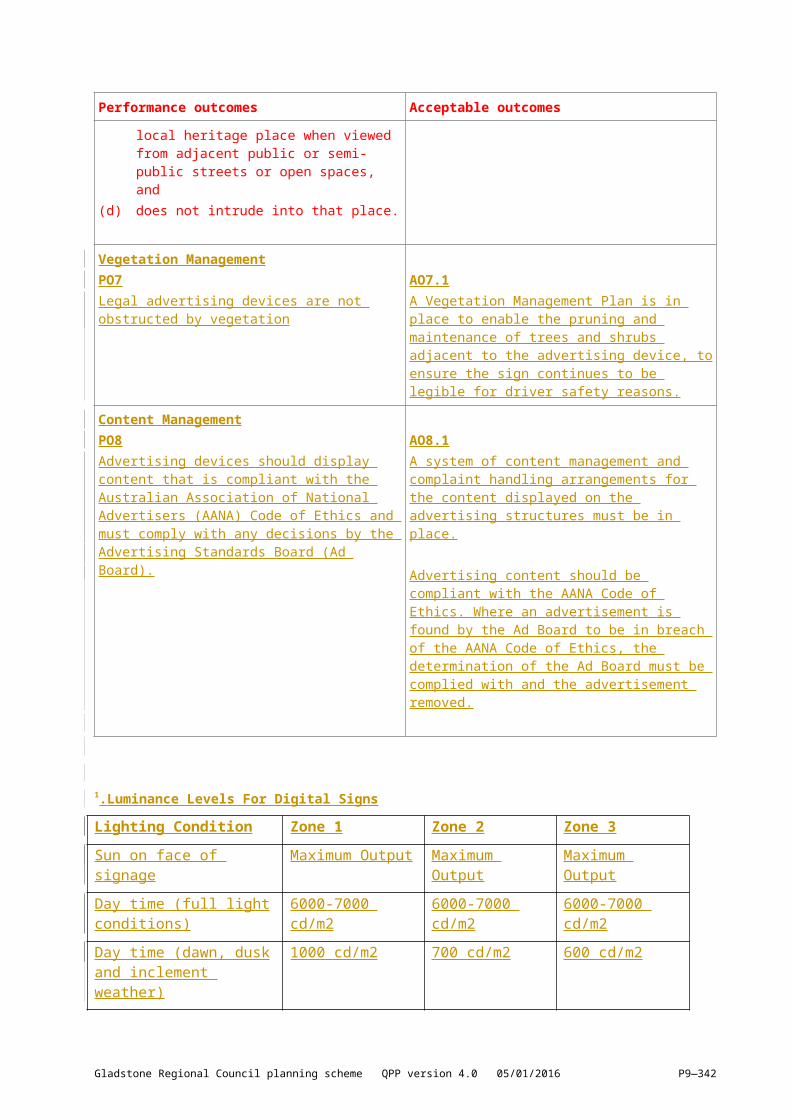
(c) does not obsecure the appearance or prominence of features of the local heritage place when viewed from adjacent public or semi-public streets or open spaces, and
(d) does not intrude into that place.
AO5AO6.1The advertising device is not proposed on or adjoining a premises that is listed as a local heritage place or shown on the heritage overlay.
Vegetation ManagementPO7Legal advertising devices are not obstructed by vegetation
AO7.1A Vegetation Management Plan is in place to enable the pruning and maintenance of trees and shrubs adjacent to the advertising device, to ensure the sign continues to be legible for driver safety reasons.
Content ManagementPO8Advertising devices should display content that is compliant with the Australian Association of National Advertisers (AANA) Code of Ethics and must comply with any decisions by the Advertising Standards Board (Ad Board).
AO8.1A system of content management and complaint handling arrangements for the content displayed on the advertising structures must be in place.
Advertising content should be compliant with the AANA Code of Ethics. Where an advertisement is found by the Ad Board to be in breach of the AANA Code of Ethics, the determination of the Ad Board must be complied with and the advertisement removed.
Gladstone Regional Council planning scheme QPP version 4.0 05/01/2016 P9—336
1
.Luminance Levels For Digital Signs
Lighting Condition Zone 1 Zone 2 Zone 3
Sun on face of signage Maximum Output Maximum Output Maximum Output
Day time (full light conditions) 6000-7000 cd/m2 6000-7000 cd/m2 6000-7000 cd/m2
Day time (dawn, dusk and inclement weather)
1000 cd/m2 700 cd/m2 600 cd/m2
Night time 500 cd/m2 350 cd/m2 300 cd/m2
Zone 1 covers areas with generally very high off-street ambient lighting, e.g. central city locations.Zone 2 covers areas with generally high to medium off-street ambient lighting.
Zone 3 covers areas with generally low levels of off-street ambient lighting e.g. most rural areas, many residential areas.
Gladstone Regional Council planning scheme QPP version 4.0 05/01/2016 P9—337
[9.3.2] Development design9.3.1.6[9.3.2.1] ApplicationThis code applies to assessing all development within the Gladstone Regional Council area where indicated in the Table of assessment.
9.3.1.7[9.3.2.2] Purpose(3) The purpose of the development design code is to:
(a) Ensure all development is provided with appropriate infrastructure, services and parking provisions.
(b) Ensure development manages stormwater and wastewater as part of the integrated total water cycle and in ways that help protect the environmental water values specified in the Environmental Protection (Water) Policy 2009.
(c) Protect surface water and ground water.(d) Ensure adverse impacts of development on the environment and the amenity of the locality
are avoided.(4) The purpose of the code will be achieved through the following overall outcomes:
(a) Development is adequately serviced by utility and access infrastructure including roads, water, waste water, power, telecommunications, stormwater management and waste management.
(b) The integrity and efficiency of utility and access infrastructure systems is maintained.(c) Environmental values of receiving water are protected from adverse development impacts
arising from stormwater quality and flow.(d) Environmental values of receiving water are protected from waste water impacts.(e) Environmental values of receiving water are protected from development impacts arising
from the creation or expansion of non–tidal artificial waterways.(f) Public health and safety are protected and damage or nuisance caused by stormwater is
avoided.(g) Stormwater is designed to maintain or recreate natural hydrological processes and minimise
run–off.(h) The function, safety and efficiency of the transport network is optimised.(i) Development within close proximity to existing or future public passenger transport facilities
supports an integrated approach to land use and transport integration.(j) Development provides adequate on–site vehicular access and adequate parking and
servicing facilities for vehicles and parking facilities for bicycles.(k) Access, parking, servicing and associated manoeuvring areas are designed to be safe,
functional and meet the reasonable demands generated by the development.(l) Provision of safe and non–discriminatory public and pedestrian access is provided.(m) Works in public streets and spaces enhance the pedestrian amenity and improve
streetscape appearance.(n) Sensitive land uses in close proximity to activities generating amenity impacts are located
and designed to mitigate their impacts.(o) Waste generation is minimised and re–use and recycling increased.(p) Development provides for the storage of generated waste in an environmentally acceptable
and nuisance free manner and waste storage facilities are functionally appropriate for users of the facilities, and
(q) Developments accessed by common private title have appropriate fire hydrant and infrastructure and unimpeded access to emergency service vehicles for the protection of people, property and environment from fire and chemical incidents.
Note—The term common private title covers areas such as roads in community title developments or strata title unit access which are private and under group or body corporate control.
Gladstone Regional Council planning scheme QPP version 4.0 05/01/2016 P9—338

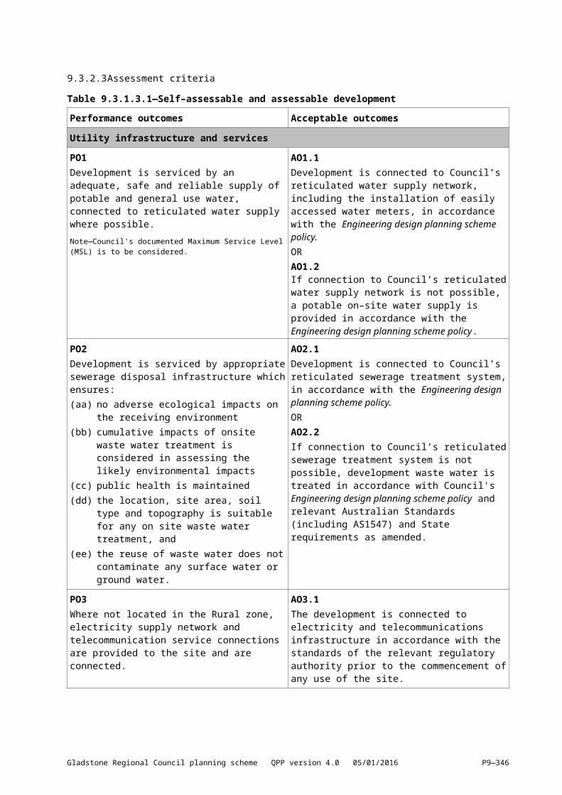
9.3.1.8[9.3.2.3] Assessment criteriaTable 9.3.1.3.1—Self–assessable and assessable development
Performance outcomes Acceptable outcomes
Utility infrastructure and servicesPO1Development is serviced by an adequate, safe and reliable supply of potable and general use water, connected to reticulated water supply where possible.Note—Council's documented Maximum Service Level (MSL) is to be considered.
AO1.1Development is connected to Council’s reticulated water supply network, including the installation of easily accessed water meters, in accordance with the Engineering design planning scheme policy.ORAO1.2If connection to Council’s reticulated water supply network is not possible, a potable on–site water supply is provided in accordance with the Engineering design planning scheme policy.
PO2Development is serviced by appropriate sewerage disposal infrastructure which ensures:(y)[(aa)] no adverse ecological impacts on the
receiving environment(z)[(bb)] cumulative impacts of onsite waste water
treatment is considered in assessing the likely environmental impacts
(aa)[(cc)] public health is maintained(bb)[(dd)] the location, site area, soil type and
topography is suitable for any on site waste water treatment, and
(cc)[(ee)] the reuse of waste water does not contaminate any surface water or ground water.
AO2.1Development is connected to Council’s reticulated sewerage treatment system, in accordance with the Engineering design planning scheme policy.ORAO2.2If connection to Council’s reticulated sewerage treatment system is not possible, development waste water is treated in accordance with Council's Engineering design planning scheme policy and relevant Australian Standards (including AS1547) and State requirements as amended.
PO3Where not located in the Rural zone, electricity supply network and telecommunication service connections are provided to the site and are connected.
AO3.1The development is connected to electricity and telecommunications infrastructure in accordance with the standards of the relevant regulatory authority prior to the commencement of any use of the site.
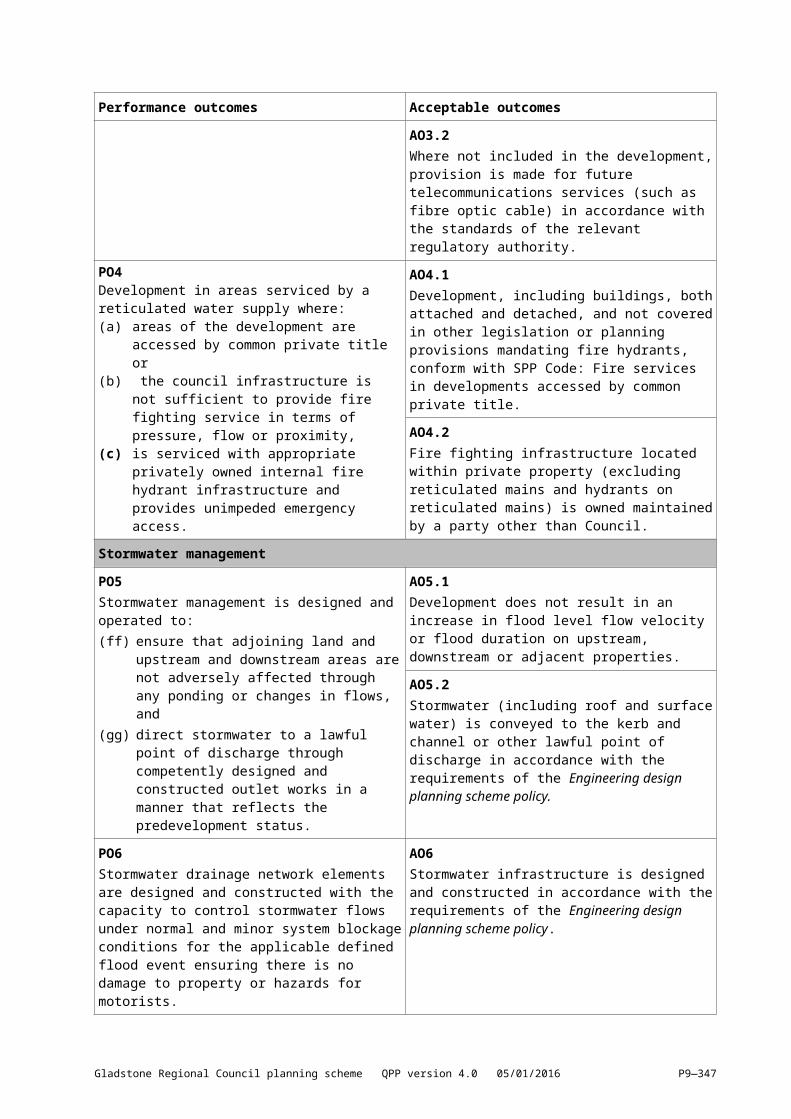
AO3.2Where not included in the development, provision is made for future telecommunications services (such as fibre optic cable) in accordance with the standards of the relevant regulatory authority.
PO4Development in areas serviced by a reticulated water supply where:(a) areas of the development are accessed by
common private title or(b) the council infrastructure is not sufficient to
provide fire fighting service in terms of pressure, flow or proximity,
(c) is serviced with appropriate privately owned internal fire hydrant infrastructure and provides unimpeded emergency access.
AO4.1Development, including buildings, both attached and detached, and not covered in other legislation or planning provisions mandating fire hydrants, conform with SPP Code: Fire services in developments accessed by common private title.
AO4.2Fire fighting infrastructure located within private property (excluding reticulated mains and hydrants on reticulated mains) is owned maintained by a party other than Council.
Gladstone Regional Council planning scheme QPP version 4.0 05/01/2016 P9—339
Performance outcomes Acceptable outcomes
Stormwater managementPO5Stormwater management is designed and operated to:(dd)[(ff)] ensure that adjoining land and upstream
and downstream areas are not adversely affected through any ponding or changes in flows, and
(ee)[(gg)] direct stormwater to a lawful point of discharge through competently designed and constructed outlet works in a manner that reflects the predevelopment status.
AO5.1Development does not result in an increase in flood level flow velocity or flood duration on upstream, downstream or adjacent properties.
AO5.2Stormwater (including roof and surface water) is conveyed to the kerb and channel or other lawful point of discharge in accordance with the requirements of the Engineering design planning scheme policy.
PO6Stormwater drainage network elements are designed and constructed with the capacity to control stormwater flows under normal and minor system blockage conditions for the applicable defined flood event ensuring there is no damage to property or hazards for motorists.
AO6Stormwater infrastructure is designed and constructed in accordance with the requirements of the Engineering design planning scheme policy.
WastewaterPO7Wastewater is managed to:(a) avoid wastewater discharge to any
waterway, and(b) if wastewater discharge to waterways cannot
be practically avoided, discharge is minimised by re–use, recycling, recovery and treatment for disposal to sewer, surface water and groundwater.
Note—Wastewater is defined in accordance with Environmental Protection (Water) Policy 2009, schedule 2).
Note—A wastewater management plan (WWMP) is prepared by a suitably qualified person and addresses:
wastewater type, and climatic conditions, and water quality objectives (WQOs), and best–practice environmental management.
AO7Development does not discharge wastewater into any waterways.
Earthworks and retaining walls
PO8Development is designed such that earthworks and any associated retaining structures:(a) result in a landform that is stable,(b) maintain as far as practical, and minimise
alteration to, the existing landforms,(c) minimise height of batter faces and retaining
structures,(d) do not unduly impact on the amenity or
privacy for occupants of the site or on adjoining land,
(e) do not unduly impact on the amenity of the streetscape,
(f) achieves a high level of visual amenity,
AO8.1Earthworks and any retaining structures (including anchors, sheet piling, seepage drains, construction requirements and retained soil etc.) and their zone of influence must:(a) be wholly contained within the development
site;(b) ensure the top and toe of any batter slope
(excluding those associated with road works) is a minimum of 0.9m horizontally from the boundary of the development site;
(c) not be located on land in Council ownership (e.g. road reserves, parks and drainage reserves)
Gladstone Regional Council planning scheme QPP version 4.0 05/01/2016 P9—340
Performance outcomes Acceptable outcomes
(g) does not prevent or obstruct the function of adjacent sites including land in Council ownership; and
(h) are designed and constructed so that they do not cause unintentional ponding (i.e. ponding not associated with stormwater control) on the site or on nearby land.
(d) not include any services within the retained soil (as determined by the internal friction angle of the soil being retained) or the zone of influence of the retaining structures' foundation; and
(e) allow for the installation and maintenance of services within any retaining structures
(f) excavating or filling is no greater than 1m.
AO8.2Development is designed such that the steepest formed batter slope is 1 vertical to 4 horizontal
AO8.3Earthworks and any associated retaining structures are designed and constructed in accordance with the Engineering Design Planning Scheme Policy
AO8.4For Reconfiguring A Lot applications:(a) constructed embankment slopes are located
along the rear and side boundaries of adjoining allotments and are designed and constructed:
i. within the development site,ii. on land which is not to enter Council
ownership,iii. within the allotment located on the low side
of the common boundary, andiv. with a top and toe at least 0.9m
horizontally from the boundary(b) retaining walls are located along the rear and
side boundaries of adjoining allotments and are designed and constructed either:
i. on the low side of the common boundary with a top at least 0.9m horizontally from the boundary; or
ii. on the high side of the common boundary with a toe at least 5m horizontally from the boundary
Parking and accessPO9Development includes the provision of adequate and convenient car and bicycle parking on–site to satisfy the anticipated requirements of the activity.
AO9Car parking and bicycle parking is provided on site in accordance with the rates specified in the Parking rates planning scheme policy.
Gladstone Regional Council planning scheme QPP version 4.0 05/01/2016 P9—341
Performance outcomes Acceptable outcomes
PO10Where in urban areas, development provides end of trip facilities to encourage people to engage in active transport (bicycles and pedestrians):(a) to meet the needs of users and promote
active modes of travel(b) at convenient, easily identifiable, safe
locations, and(c) in locations that do not obstruct vehicular,
bicycle or pedestrian movement paths.
AO10Development provides cycling and pedestrian end of trip facilities, in accordance with the requirements of the Queensland Development Code.
PO11Access driveways are designed and constructed to:(ff)[(hh)] provide convenient access to the site and
maintain the safety and efficiency of the road(gg)[(ii)] minimise conflicts with traffic and
pedestrians, and(hh)[(jj)] are constructed to a standard that is
appropriate to the location and to meet the anticipated volume and type of traffic.
AO11.1Access driveways are:(ii)[(kk)] designed and constructed in accordance
with the Engineering design planning scheme policy, and
(jj)[(ll)] in accordance with AS2890 as amended, and
(kk)[(mm)] certified by a Registered Professional Engineer of Queensland.
AO11.2Access driveways allow vehicles (with the exception of dwelling house and dual occupancy) to enter and exit the site in a forward gear.
PO12(ll)[(nn)] Vehicle movement areas (including
internal driveways, access aisles, manoeuvring areas, parking areas (car and bicycle) and service bays) are designed to ensure:(i) a gradient appropriate for the type of
vehicles(ii) a surface suitable for the proposed
use(iii) effective stormwater drainage(iv) clearly marked and signed spaces(v) convenience and safety for drivers
and pedestrians, and(vi) adequate dimensions to meet user
requirements, including access and egress for emergency vehicles.
AO12Manoeuvring, loading and unloading areas, and parking areas (car and bicycle) are:(mm)[(oo)] designed and constructed in
accordance with the Engineering design planning scheme policy
(nn)[(pp)] Imperviously sealed using concrete or asphalt bitumen
(oo)[(qq)] In accordance with AS2890 as amended, and
(pp)[(rr)] certified by a Registered Professional Engineer of Queensland.
PO13Footpaths provide pedestrian and bicycle access to the site, which is designed to:(a) provide safe movement;(b) avoid unnecessary conflict between
pedestrians, bicycles and motor vehicles;(c) include durable and stable materials; and(d) match any adjacent footpath.
AO13Footpaths are:(qq)[(ss)] provided to the full road frontage and
designed in accordance with the Engineering Design Planning Scheme Policy
(rr)[(tt)] connected to the existing footpath network, and
(ss)[(uu)] certified by a Registered Professional Engineer of Queensland.
Gladstone Regional Council planning scheme QPP version 4.0 05/01/2016 P9—342

Performance outcomes Acceptable outcomes
PO14Pedestrian access to buildings:(tt)[(vv)] does not obstruct pedestrian movement (or
form physical clutter) on public footpaths(uu)[(ww)] are not visually overbearing (or form
visual clutter) in the streetscape, and(vv)[(xx)] provide safe, efficient, equitable and
convenient access including wheelchair access.
AO14Pedestrian access steps, escalators, ramps and lifts are:(ww)[(yy)] located wholly within the site(xx)[(zz)] setback a minimum of 1.5m from the front
boundary, and(yy)[(aaa)] compliant with the Disability
Discrimination Act 1992.
Acoustic and air qualityPO15Development minimises potential conflicts with, or impacts on, other uses having regard to odour, dust or other emissions.
AO15Development achieves the air quality design objectives set out in the Environmental Protection (Air) Policy 2008, as amended.
PO16Development prevents or minimises the generation of any noise or vibration so that:(zz)[(bbb)] nuisance is not caused to adjoining
premises or other nearby sensitive land uses, and
(aaa)[(ccc)] desired ambient noise levels in residential areas are not exceeded.
AO16Development achieves the noise generation levels set out in the Environmental Protection (Noise) Policy 2008, as amended.Note—To achieve compliance, development is planned, designed and managed to ensure emissions from activities to achieve the appropriate acoustic objectives (measured at the receptor dB(A)).
PO17Sensitive development adjacent to State controlled roads or Council controlled arterial and sub–arterial roads minimise through their own design the nuisance caused by noise, vibration and dust emissions.
AO17Sensitive development (other than Class 1, 2, 3 or 4 buildings) complies with the requirements of the Department Main Roads – Road Traffic Noise Management Code of Practice and the Environmental Protection (Noise) Policy 2008.
LightingPO18External lighting is provided in urban areas to ensure a safe environment.
AO18Technical parameters, design, installation, operation and maintenance of outdoor lighting comply with the requirements of AS4282 – Control of the Obtrusive Effects of Outdoor Lighting as amended.
PO19Outdoor lighting does not cause undue disturbance to any person, activity or fauna because of emission, either directly or by reflection.
AO19The vertical illumination resulting from direct, reflected or other incidental light coming from a site does not exceed 8 lux when measured at any point 1.5m outside of the boundary of the property at any level from ground level up.
PO20Street lighting and signs are provided to ensure the safety of both vehicles and pedestrians, and to facilitate access and movement.
AO20Street lighting and signage comply with the requirements of the Engineering design planning scheme policy.
Gladstone Regional Council planning scheme QPP version 4.0 05/01/2016 P9—343
Performance outcomes Acceptable outcomes
Waste managementPO21Development:(a) minimises waste generation (including
construction, demolition and operational waste)
(b) provides adequate facilities on–site for the storage of waste and recyclables.
AO21Waste storage and management arrangements are sited, screened and designed in accordance with the Waste Management Planning Scheme Policy.
PO22Development is designed to allow for safe and efficient servicing of waste and recycling containers through:(bbb)[(ddd)] a development layout that is designed
to facilitate direct and unobstructed servicing of waste and recycling containers, and
(ccc)[(eee)] minimising the potential for nuisances to be caused by way of noise and odour.
AO22.1Where on–site waste and recycling collection services are proposed:(ddd)[(fff)] collection vehicle entry and exit from the
site is carried out in a forward motion, and(eee)[(ggg)] the proposed point of servicing is
designed in accordance with the Waste Management Planning Scheme Policy.
AO22.2Where on–street (kerbside) collection is proposed for any standard waste and recycling containers or bulk bin waste and recycling, waste management is designed in accordance with the Waste Management Planning Scheme Policy.
For all assessable developmentStormwater managementPO23Stormwater management systems:(a) implement water sensitive urban design
(WSUD) principles that:(i) protect natural systems and
waterways(ii) allow for the detention of stormwater
instead of rapid conveyance(iii) minimise impervious areas(iv) utilise stormwater to conserve potable
water(v) integrate stormwater treatment into
the landscape(vi) ensure water quality values are
protected(b) where privately owned must be maintained
(including costs) for the life of the system(c) provide for safe access and maintenance(d) maintain natural drainage lines and
adequate filtering and settlement of sediment for the protection of watercourses, coastal wetlands and beaches from point source and non–point source stormwater discharges, and
(e) are designed to minimise ongoing maintenance costs
AO23Stormwater management systems are designed and constructed in accordance with the Engineering Design Planning Scheme Policy.Note—A site stormwater quality management plan (SQMP) is prepared in accordance with Engineering Design Planning Scheme Policy and the State Planning Policy requirement for stormwater quality treatment measures.
Gladstone Regional Council planning scheme QPP version 4.0 05/01/2016 P9—344
Performance outcomes Acceptable outcomes
PO24Development allows for sufficient site area to accommodate an effective stormwater management system.
No acceptable outcome specified.
PO25Development provides for the orderly development of stormwater infrastructure within a catchment, having regard to:(fff)[(hhh)] existing capacity of stormwater
infrastructure and ultimate catchment conditions
(ggg)[(iii)] discharge for existing and future upstream development.
No acceptable outcome specified.
PO26Construction activities for the development avoid or minimise adverse impacts on stormwater quality.
AO26The release of sediment–laden stormwater is avoided for the nominated design storm, and minimised when the nominated design storm is exceeded, by addressing design objectives listed below in Table 9.3.1.3.2—Construction phase, or local equivalent for:(hhh)[(jjj)] drainage control(iii)[(kkk)] erosion control(jjj)[(lll)] sediment control, and(kkk)[(mmm)] water quality outcomes.Note—An Erosion and Sediment Control Plan (ESCP) is prepared by a suitably qualified person that demonstrates:
erosion and sediment control practices (including any proprietary erosion and sediment control products) are designed, installed, constructed, operated, monitored and maintained, and any other erosion and sediment control practices are carried out in accordance with local conditions, or
how stormwater quality will be managed in accordance with an acceptable regional or local guideline so that target contaminants are treated to a design objective at least equivalent to this Acceptable outcome.
PO27Reconfiguration of lots includes stormwater management measures in the design of any road reserve, streetscape or drainage networks to:(lll)[(nnn)] minimise impacts on the water cycle(mmm)[(ooo)] protect waterway health by
improving stormwater quality and reducing site run–off, and
(nnn)[(ppp)] avoid large impervious surfaces.
No acceptable outcome specified.
Wastewater ManagementPO28Wastewater discharge maintains ecological processes, riparian vegetation, waterway integrity, and downstream ecosystem health including:(a) protecting applicable water quality objectives
for the receiving waters(b) managing soil disturbance or altering natural
hydrology in coastal areas
No acceptable outcome specified.
Gladstone Regional Council planning scheme QPP version 4.0 05/01/2016 P9—345
Performance outcomes Acceptable outcomes
(c) avoiding or minimising the release of nutrients of concern so as to minimise the occurrence, frequency and intensity of coastal algal blooms, and
(d) avoiding lowering groundwater levels where potential or actual acid sulfate soils are present in coastal areas.
Note—Compliance with part of this performance outcome may be demonstrated by following the management advice in the guideline: Implementing Policies and Plans for Managing Nutrients of Concern for Coastal Algal Blooms in Queensland by the Department of Environment and Heritage Protection.
PO29Where involving trade waste or contaminated wastewaters, they are managed so that:(ooo)[(qqq)] the pH of any wastewater discharged
is maintained between 6.5 and 8.5 to avoid mobilisation of acid, iron, aluminium, and metals
(ppp)[(rrr)] holding times of neutralised wastewaters ensures the flocculation and removal of any dissolved iron prior to release
(qqq)[(sss)] visible iron floc is not present in any discharge
(rrr)[(ttt)] precipitated iron floc is contained and disposed of, and
(sss)[(uuu)] wastewater and precipitates that cannot be contained and treated for discharge on site are removed and disposed of through trade waste.
No acceptable outcome specified.
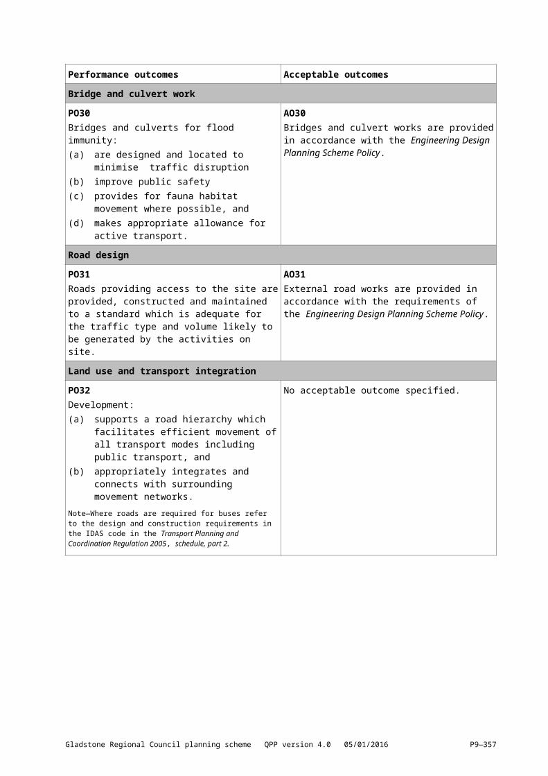
Bridge and culvert workPO30Bridges and culverts for flood immunity:(a) are designed and located to minimise traffic
disruption(b) improve public safety(c) provides for fauna habitat movement where
possible, and(d) makes appropriate allowance for active
transport.
AO30Bridges and culvert works are provided in accordance with the Engineering Design Planning Scheme Policy.
Road designPO31Roads providing access to the site are provided, constructed and maintained to a standard which is adequate for the traffic type and volume likely to be generated by the activities on site.
AO31External road works are provided in accordance with the requirements of the Engineering Design Planning Scheme Policy.
Land use and transport integrationPO32Development:(a) supports a road hierarchy which facilitates
efficient movement of all transport modes
No acceptable outcome specified.
Gladstone Regional Council planning scheme QPP version 4.0 05/01/2016 P9—346
Performance outcomes Acceptable outcomes
including public transport, and(b) appropriately integrates and connects with
surrounding movement networks.Note—Where roads are required for buses refer to the design and construction requirements in the IDAS code in the Transport Planning and Coordination Regulation 2005, schedule, part 2.
PO33Development enhances connectivity between existing and future public passenger transport facilities and other transport modes through:(a) providing direct linkages for passengers
between existing and future public passenger transport facilities and other transport modes, and
(b) way–finding information for existing public transport facilities and interconnecting transport modes.
No acceptable outcome specified.
PO34Development provides direct, safe and equitable access to and use of public passenger transport facilities.
AO34Public passenger transport facilities and any through–site pathway connections, including road crossings, to public passenger transport facilities are provided in accordance with the Engineering Design Planning Scheme Policy and the Disability Discrimination Act 1992..
PO35Development is located and designed to maintain the operational and structural efficiency of public utility infrastructure.
No acceptable outcome specified.
Acoustic and air qualityPO36Where located in close proximity to an operational railway corridor, sensitive land uses mitigate amenity impacts and maintain the operational integrity of the rail corridors.
No acceptable outcome specified.
PO37Utility services and service structures attached to buildings, do not adversely impact on the acoustic or visual amenity of the surrounding area and are:(a) located as far from sensitive land uses, road
frontage boundaries and public open spaces as practical, and
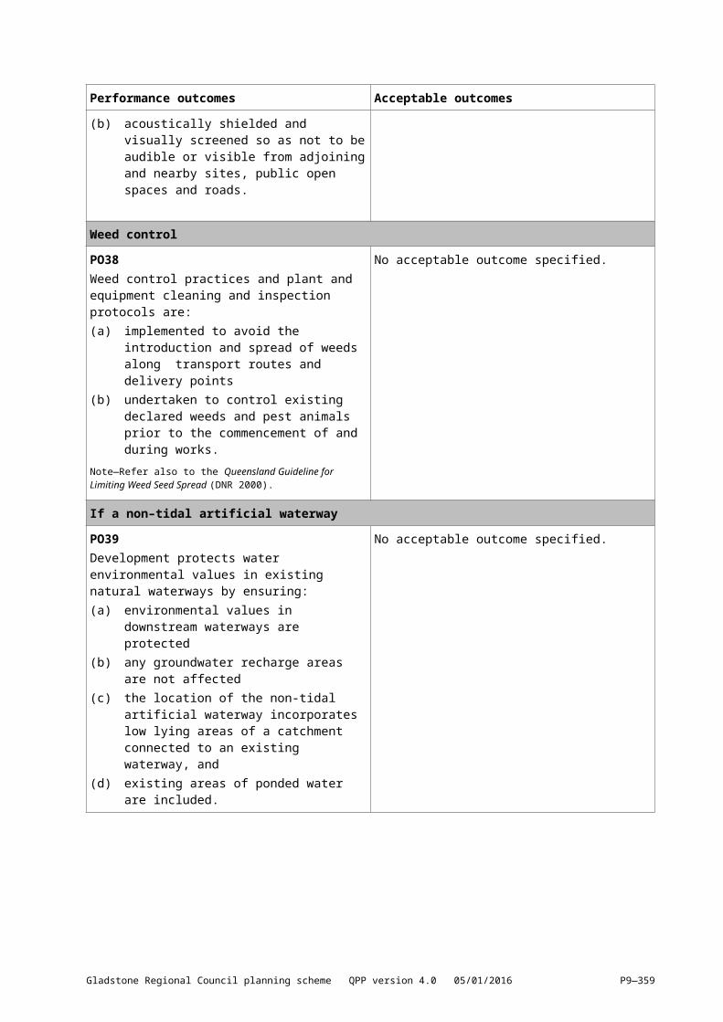
(b) acoustically shielded and visually screened so as not to be audible or visible from adjoining and nearby sites, public open spaces and roads.
No acceptable outcome specified.
Weed controlPO38Weed control practices and plant and equipment cleaning and inspection protocols are:(a) implemented to avoid the introduction and
No acceptable outcome specified.
Gladstone Regional Council planning scheme QPP version 4.0 05/01/2016 P9—347
Performance outcomes Acceptable outcomes
spread of weeds along transport routes and delivery points
(b) undertaken to control existing declared weeds and pest animals prior to the commencement of and during works.
Note—Refer also to the Queensland Guideline for Limiting Weed Seed Spread (DNR 2000).
If a non–tidal artificial waterwayPO39Development protects water environmental values in existing natural waterways by ensuring:(a) environmental values in downstream
waterways are protected(b) any groundwater recharge areas are not
affected(c) the location of the non-tidal artificial
waterway incorporates low lying areas of a catchment connected to an existing waterway, and
(d) existing areas of ponded water are included.
No acceptable outcome specified.
PO40Development is designed such that non-tidal artificial waterways are located:(a) outside natural wetlands and any associated
buffer areas(b) to minimise disturbing soils or sediments.
and(c) to avoid altering the natural hydrologic
regime in acid sulfate soil and nutrient hazardous areas.
No acceptable outcome specified.
PO41Development is compatible with existing tidal waterways where any tidal flow alteration does not adversely impact on the tidal waterway.
AO41Where development is located adjacent to, or is connected to, a tidal waterway by means of a weir, lock, pumping system or similar:(a) there is sufficient flushing or a tidal range
greater than 0.3m, and(b) there is no introduction of salt water into
freshwater environments.
PO42Any non-tidal artificial waterway associated with the development is designed and managed to function by:(a) providing amenity including aesthetics,
landscaping and recreation(b) incorporating flood management measures(c) including stormwater harvesting as part of an
integrated water cycle management plan, and(d) accommodating aquatic habitat.
No acceptable outcome specified.
PO43Any non-tidal artificial waterways associated with the development are designed, managed and
No acceptable outcome specified.
Gladstone Regional Council planning scheme QPP version 4.0 05/01/2016 P9—348
Performance outcomes Acceptable outcomes
operated to achieve water quality objectives in natural waterways through:(a) monitoring and maintenance programs
adaptively manage water quality in any non–tidal artificial waterway to achieve relevant water–quality objectives downstream of the waterway, and
(b) monitoring and maintenance programs that ensure aquatic weeds achieve a low percentage of coverage of the water surface area (less than 10%) and pests and vectors (such as mosquitoes) are managed through avoiding stagnant water areas, providing for native fish predators, and any other best practices for monitoring and treating pests.
Note—Achieving compliance with the performance outcomes is to be undertaken by suitably qualified persons such as a registered professional engineer, Queensland (RPEQ) with specific experience in establishing and managing artificial waterways
Note—Any non–tidal artificial waterway is managed and operated by a responsible entity under agreement for the life of the waterway. The responsible entity is to implement a deed of agreement for the management and operation of the waterway that:
identifies the waterway states a period of responsibility for the entity states a process for any transfer of responsibility for the
waterway states required actions under the agreement for
monitoring the water quality of the waterway and receiving waters
states required actions under the agreement for maintaining the waterway to achieve the outcomes of this code and any relevant conditions of a development approval, and
identifies funding sources for the above, including bonds, headworks charges or levies.
If Port services where a Marina (ship sourced pollutants reception facilities)PO44Development provides facilities for the handling and disposal of ship–sourced pollutants that minimises impacts on the environment and include:(a) facilities that are designed and operated to
ensure the risk of spillage from operations is minimised
(b) common user facilities are situated in a suitable location with appropriate equipment available for immediate use to contain and remove spillages, and
(c) a pollutant reception facility that is connected to sewerage or other waste reception infrastructure, where practical.
Note—Refer to Australian and New Zealand Environment and Conservation Council (ANZECC), 1997, Best Practice Guidelines for Waste Reception Facilities at Ports, Marinas and Boat Harbours in Australia and New Zealand.
Note—Reception facilities require compliance assessment under the Plumbing and Drainage Act 2002. The plumbing
No acceptable outcome specified.
Gladstone Regional Council planning scheme QPP version 4.0 05/01/2016 P9—349
Performance outcomes Acceptable outcomes
compliance assessment process will ensure that the proposed facilities address ‘peak load’.
Structures over multiple lotsPO45Where buildings and structures are located on multiple lots, these are amalgamated to form one lot.
AO45No acceptable outcome specified.
Table 9.3.1.3.2—Construction phase: stormwater management design objectives
Issue Design objectives
Drainage control Temporary drainage works
(ttt)[(vvv)] Design life and design storm for temporary drainage works:(i) disturbed area open for < 12 months—1 in
2–year ARI event(ii) disturbed area open for 12–24 months—1
in 5–year ARI event(iii) disturbed area open for > 24 months—1 in
10–year ARI event(uuu)[(www)] design capacity excludes minimum 150
mm freeboard(vvv)[(xxx)] temporary culvert crossing—minimum 1 in
1–year ARI hydraulic capacity.
Erosion control Erosion control measures
(a) Minimise exposure of disturbed soils at any time(b) divert water run–off from undisturbed areas
around disturbed areas(c) determine the erosion risk rating using local
rainfall erosivity, rainfall depth, soil–loss rate or other acceptable methods
(d) implement erosion control methods corresponding to identified erosion risk rating.
Sediment control Sediment control measuresDesign storm for sediment control basinsSediment basin dewatering
(www)[(yyy)] Determine appropriate sediment control measures using:(i) potential soil loss rate, or(ii) monthly erosivity, or(iii) average monthly rainfall
(xxx)[(zzz)] collect and drain stormwater from disturbed soils to sediment basin for design storm event:(i) design storm for sediment basin sizing is
80th% five–day event or similar(yyy)[(aaaa)] site discharge during sediment basin
dewatering:(i) TSS < 50 mg/L TSS, and(ii) Turbidity not >10% receiving waters
turbidity, and(iii) pH 6.5–8.5.
Water quality Litter and other waste, hydrocarbons and other contaminants
(a) avoid wind–blown litter; remove gross pollutants(b) ensure there is no visible oil or grease sheen on
released waters(c) dispose of waste containing contaminants at
Gladstone Regional Council planning scheme QPP version 4.0 05/01/2016 P9—350
Issue Design objectives
authorised facilities
Waterway stability and flood flow management
Changes to the natural waterway hydraulics and hydrology
For peak flow for the 1–year and 100–year ARI event, use constructed sediment basins to attenuate the discharge rate of stormwater from the site.
9.3.2[9.3.3] Extractive industry9.3.2.1[9.3.3.1] ApplicationThis code applies to assessing a material change of use for extractive industry development.
9.3.2.2[9.3.3.2] Purpose(1) The purpose of the extractive industry code is to:
(a) Facilitate the optimum use of extractive resources in identified areas in the region limited to the Extractive resources and minerals overlay area and parts of the Rural zone.
(b) Ensure extractive industry operations occur in a manner that minimises impacts on public safety, amenity, the natural environment, road traffic and the road network.
(c) Ensures rehabilitation occurs following extraction.(2) The purpose of the code will be achieved through the following overall outcomes:
(a) Extractive industry activities including haulage routes are separated from sensitive uses to mitigate encroachment on extractive industry operations by sensitive uses, and
(b) Extractive industry operational impacts on sensitive uses including visual, light, vibration, air, noise and water quality impacts.
(c) Extractive industry activities are designed and managed to mitigate as far as possible, impacts on the site’s and surrounding area’s environmental values.
(d) Extractive industry activities are designed and managed as far as possible to protect the visual amenity and landscape character of the surrounding area.
(e) Conflict on the region’s road network between public road users and haulage traffic is minimised through the use of specified transport routes by heavy vehicles.
(f) Land disturbed by extractive industry activities is progressively rehabilitated to ensure the site is environmentally stable and capable of reuse.
9.3.2.3[9.3.3.3] Assessment criteriaTable 9.3.2.3.1—Criteria for assessable development
Performance outcomes Acceptable outcomes
Design and operationPO1The extractive industry is located and operated to maintain public safety and minimise potential visual, light, vibration, air, noise and water quality impacts on nearby areas and sensitive land uses.
AO1.1Extractive industry activities are separated from nearby areas in accordance with the following:(a) where the extraction or processing of the
extractive resource involves blasting or crushing (namely rock), a minimum distance of 1,000m from:(i) sensitive land uses(ii) public roads, and(iii) driveways of adjoining and nearby
properties(b) for any other extractive resource not
involving blasting or crushing (namely sand, gravel, clay and soil), a minimum distance of 200m.
AO1.2
Gladstone Regional Council planning scheme QPP version 4.0 05/01/2016 P9—351
Performance outcomes Acceptable outcomes
Extractive industry activities visible from outside the property are designed to be screened from surrounding land and protected by a 50m buffer from boundary ridges.
AO1.3Extractive industry activities are screened from view from public roads, public vantage points and sensitive land uses by:(a) natural topographic features such as
ridgelines, or(b) a minimum 30m wide landscaped native
vegetation buffer.
AO1.4Noise and vibration impacts do not exceed acceptable levels contained within the Environmental Protection (Noise) Policy 2008, as amended.
AO1.5Air quality impacts including dust do not exceed acceptable levels contained within the Environmental Protection (Air) Policy 2008, as amended.
AO1.6Blasting and crushing operations are limited to the hours of 9am to 5pm Monday to Friday.
AO1.7Other extractive industry operations are limited to the hours of 6am to 6pm Monday to Saturday.
PO2Extractive industry operations protect the visual and landscape character of hilltops and ridgelines.
AO2Extractive industry operations areas are located a minimum of 50m from any hilltop or ridgeline (measured horizontally from the peak).
PO3Extractive industry operations avoid or minimises impact on areas of ecological significance, ecological processes or biodiversity values external to the site.
No acceptable outcome is nominated.
Stormwater managementPO4Stormwater drainage systems are designed, constructed and maintained to:(a) prevent ponding in excavated areas(b) minimise and control erosion(c) prevent pollution of ground and surface
water, and(d) provide opportunities to conserve and re–
use water on site.
No acceptable outcome is nominated.
Gladstone Regional Council planning scheme QPP version 4.0 05/01/2016 P9—352

Performance outcomes Acceptable outcomes
Public safety and accessPO5Public safety is maintained by:(a) preventing public access into operations
areas, and(b) informing the public of the presence and
nature of operations.
AO5.1Public entry is prevented through the provision of:(a) security fencing with a minimum height of
1.8m on the perimeter of the site, and(b) security gates a minimum height of 1.8m at
all access points.
AO5.2Signs that inform of operations and safety hazards, are installed on:(a) any public road adjoining the site, and(b) gates/fencing surrounding the site.
HaulagePO6Extractive industry activities are located to ensure:(a) the safe and efficient operation of vehicles
transporting extractive materials, and(b) extractive industry haulage vehicles access
the site on designated haulage routes.Note—Designated haulage routes are identified on the Extractive resources and minerals overlay map.
No acceptable outcome is nominated.
RehabilitationPO7Progressive and staged rehabilitation of completed extraction sites must be undertaken that incorporates:(a) decontamination of both soil and water(b) land profiling to establish useable and stable
landforms and soil profiles(c) revegetation with native plant species, and(d) monitoring and maintenance of works and
rehabilitation sites.
No acceptable outcome is nominated.
PO8Rehabilitation ensures created water bodies will be useable by the establishment of suitable water quality, hydraulic and bed and bank conditions.
AO8Created water bodies:(a) have a depth and bed and bank profile
suitable to establish and sustain aquatic vegetation
(b) establish water quality suitable to establish and sustain aquatic vegetation and animal, and
(c) are revegetated and stocked to establish native aquatic vegetation and fauna communities and riparian vegetation.
Gladstone Regional Council planning scheme QPP version 4.0 05/01/2016 P9—353
9.3.3[9.3.4] Home based business9.3.3.1[9.3.4.1] ApplicationThis code applies to a material change of use for home based business where the code is identified as applicable in the tables of assessment. When using this code, reference should be made to section 5.3.2 and where applicable, section 5.3.3 located in Part 5.
9.3.3.2[9.3.4.2] Purpose(1) The purpose of the home based business use code is to ensure that home based business uses
are subordinate to a dwelling and residential activity and do not adversely impact on the amenity of surrounding residential activities.
(2) The purpose of the code will be achieved through the following overall outcomes:(a) The scale and intensity of development is low impact.(b) Development does not compromise the viability of designated centres and employment
areas.(c) Development does not adversely impact on the amenity of adjoining premises.(d) Development maintains the character of residential neighbourhoods.
9.3.3.3[9.3.4.3] Assessment criteria Table 9.3.3.3.1—Criteria for self–assessable and assessable development
Performance outcomes Acceptable outcomes
For self–assessable and assessable developmentPO1Development is of a scale and intensity similar to surrounding dwellings.
AO1.1Development has a maximum GFA of 100m2.
AO1.2Development generates a demand for no more than 10 vehicular trips to and from the site per day.
AO1.3Development generates a demand for no more than 1 delivery per week from a delivery vehicle exceeding 2.5 tonnes in weight.
AO1.4The home based business is conducted by:(a) 1 or more of the permanent residents of the
principal dwelling house, and(b) no more than 2 non–resident employees at
any time.
AO1.5Development is wholly contained within the dwelling house or ancillary outbuilding on the site.
Gladstone Regional Council planning scheme QPP version 4.0 05/01/2016 P9—354
Performance outcomes Acceptable outcomes
AO1.6Bed and breakfast accommodation:(a) is wholly contained within the principal
dwelling house on the site(b) allows a maximum continuous period of stay
for any guest of no more than 4 weeks(c) does not contain more than:
(i) 2 guest bedrooms if within a residential, centre, township or rural residential zone, or
(ii) 4 guest bedrooms if within the rural zone.
PO2Development is consistent with the streetscape character of the zone.
AO2Goods, equipment and activities associated with the development are not visible from the street or adjoining premises.
PO3Development does not adversely impact on the amenity of area.
AO3The home based business (where not a Bed and breakfast) is conducted between the hours of:(a) 7am to 7pm on week days, and(b) 7am to 1pm on Saturdays.
PO4Vehicle parking (not associated with the dwelling):(a) is associated with the onsite home based
business, and(b) does not adversely affect the amenity of
neighbouring properties.
AO4.1Not more than 2 vehicles associated with the home based business is parked on the site at any one time.
AO4.2Activities on the premises do not involve the repairing, servicing, cleaning, or loading of motor vehicles.
Gladstone Regional Council planning scheme QPP version 4.0 05/01/2016 P9—355
9.3.4[9.3.5] Landscaping9.3.4.1[9.3.5.1] ApplicationThis code applies to development where the code is identified as applicable in a table of assessment. When using this code, reference should be made to section 5.3.2 and where applicable, section 5.3.3 located in Part 5.
9.3.4.2[9.3.5.2] Purpose(1) The purpose of the landscape code is to ensure landscaping in both the private and public domain:
(a) Complements built form, topography and existing landscape elements.(b) Enhances the visual appeal and local identity of different places throughout the region.(c) Is designed and constructed to a high standard.(d) Is functional for users and remains fit for purpose over the long–term.
(2) The purpose of the code will be achieved by the following overall outcomes: (a) Landscaping creates shade and shelter on streets and public spaces.(b) Landscaping conserves energy, water usage and creates comfortable microclimates.(c) Landscaping creates high quality streetscapes and enhances local character.(d) Landscape design is used to integrate the natural and built form elements of the site and the
locality.(e) Landscape elements contribute to the useability, legibility and understanding of the city and
the region and its places.(f) Landscaping is used for screening to soften built form, mitigate adverse aesthetic impacts,
improve amenity and provide privacy.(g) Plant species and landscaping materials are suitable for local climatic conditions.(h) Plant species, landscaping materials and surface treatments are suited to their intended
function and user requirements and are designed to remain attractive, fit for purpose and be cost effective to maintain over the long–term.
(i) Landscape design facilitates an accessible, safe and comfortable environment for all users.(j) Mature on–site vegetation is retained, protected and integrated into the site design wherever
practicable.
9.3.4.3[9.3.5.3] Assessment criteriaTable 9.3.4.3.1—Assessable development
Performance outcomes Acceptable outcomes
General landscape design and worksPO1Landscape design of both public and private spaces:(a) complements the intended character of the
streetscape and zone, and(b) is functional and designed to be visually
appealing in the long–term.
No acceptable outcome is nominated.
PO2Landscape works and plant selection ensure:(zzz)[(bbbb)] climatically appropriate species are
planted(aaaa)[(cccc)] the provision of shade in appropriate
locations(bbbb)[(dddd)] an appropriate mix of soft and hard
elements, and(cccc)[(eeee)] planting densities and stock sizes
are suitable for their location, purpose and hardiness.
AO2.1Selected tree species within communal recreation areas are to provide at least 30% shade coverage within 5–10 years of planting.
AO2.2A minimum of 50% of landscaped areas are to be covered in soft landscaping (turf areas and planting beds), with at least 25% of that area being planting.
Gladstone Regional Council planning scheme QPP version 4.0 05/01/2016 P9—356
Performance outcomes Acceptable outcomes
PO3Street trees are provided in appropriate locations to:(dddd)[(ffff)] provide shade for pedestrians along
footpaths(eeee)[(gggg)] reinforce the legibility of the
movement network(ffff)[(hhhh)] avoid damage to public or private
property or infrastructure(gggg)[(iiii)] enhance the character of the
streetscape, and(hhhh)[(jjjj)] ensure visibility is maintained from
entrances and exits to properties and at intersections.
AO3.1Street trees are provided at the rate whichever is the lesser of:(iiii)[(kkkk)] one street tree per lot frontage or one
tree per 10 linear metres of road frontage or(jjjj)[(llll)] a minimum of 1 tree per 400m2 of site
area.
AO3.2Species of street trees are selected in accordance with the plant species list in Table 9.3.4.3.2
PO4Street treatments including pavement, seating, lighting, rubbish bins are provided to:(a) enhance the usability and amenity of streets
and public spaces(b) facilitate social interaction, and(c) maintain clean streetscapes.
No acceptable outcome is nominated.
PO5Wherever possible, landscape design facilitates the retention and integration of mature existing vegetation, both within and external to the site.
AO5.1Existing mature trees and vegetation are retained and incorporated into the landscape design.
AO5.2Removed or damaged mature vegetation is replaced with mature vegetation of a comparable quantity and species.
Landscaping along boundaries and edgesPO6Planting and landscape elements along boundaries and edges assist in:(a) maintaining privacy between adjoining
buildings(b) protecting local views, vistas and sightlines(c) enhancing the visual appearance of the built
form(d) screening service, utility and parking areas(e) minimising noise impacts between noise
sources and sensitive receiving environments, and
(f) reducing the visual impact of acoustic fences, retaining walls and long unbroken walls.
No acceptable outcome is nominated.
Open air car parkingPO7 AO7.1
Shade trees are located at the rate of 1 tree per 6 car spaces.
Gladstone Regional Council planning scheme QPP version 4.0 05/01/2016 P9—357
Performance outcomes Acceptable outcomes
Open air car parking areas are provided with suitable levels of shade through the use of appropriate planting.
AO7.2Wheel stops are provided to protect vegetation.
AO7.3Tree selection is in accordance with plant species list.
SustainabilityPO8Landscape design including irrigation methods optimise water and energy efficiency and responds appropriately to local conditions, by:(kkkk)[(mmmm)] maximising the exposure to the
prevailing summer breezes and the north–east winter morning sun
(llll)[(nnnn)] minimising exposure to the prevailing winter winds and western summer sun
(mmmm)[(oooo)] optimising shade to create useable and comfortable areas, and
(nnnn)[(pppp)] maintaining infiltration to subsurface soil.
No acceptable outcome is nominated.
SafetyPO9Landscape elements enhance the safety, legibility of places and do not undermine the surveillance of paths, walkways, parking areas, streets and public spaces by ensuring:(oooo)[(qqqq)] landscape elements (including
signage and other infrastructure) does not interfere with sightlines
(pppp)[(rrrr)] spaces are well lit, free from obstructions and clearly defined by landscape treatments, and
(qqqq)[(ssss)] public and private areas are clearly distinguishable and accessible.
Note—Applicants should have regard to Crime Prevention through Environmental Design Guidelines for Queensland.
AO9.1Plant selection adjacent to pedestrian movement areas provides a clear trunk of at least 2m at maturity.
AO9.2Understorey planting maintains a height of less than 600mm at maturity.
MaintenancePO10Landscape elements do not adversely affect stormwater quantity or quality by ensuring:(a) the flow of water along overland flow paths is
not restricted(b) opportunities for water infiltration are
maximised, and(c) areas of pavement, turf and mulched garden
beds are appropriately located and adequately drained.
No acceptable outcome is nominated.
Gladstone Regional Council planning scheme QPP version 4.0 05/01/2016 P9—358
Performance outcomes Acceptable outcomes
PO11Landscape elements:(a) provide high levels of durability and
robustness(b) are cost effective, and(c) have the ability to be maintained
conveniently over the long–term.
No acceptable outcome is nominated.
PO12Drainage of podium planters allows for flush out in future and is adequately drained.
No acceptable outcome is nominated.
PO13Landscape works and plant selection protects the structural integrity and function of:(rrrr)[(tttt)] buildings and structures;(ssss)[(uuuu)] overhead and underground services,
and(tttt)[(vvvv)] other forms of infrastructure.
No acceptable outcome is nominated.
Table 9.3.4.3.2—Plant species listBotanical name Common name Height
metresSpread metres
Endemic Y/N
Street trees
Acanthus mollisAcmena brachyandra Red Apple 12 6 NAcmena smithii Lilly Pilly 6 5 YAcronychia imperforata* Fraser Island Apple 3 2 YAdiantum spp. Maidenhair Ferns 0.5 0.5Alectryon connatus 4 2 NAleurites moluccana Candle Nut 12 6 YAllocasuarina littoralis Black She–Oak 8 5 YAllocasuarina torulosa Forest She–Oak 6 5 YAlphitonia excelsa Red Ash 6 5 YAlphitonia petriei Pink Ash Pink Ash 12 8 YAngophora leiocarpa Smooth Barked Apple 10 4 YAnigozanthos spp. Kangaroo PawsAraucaria bidwillii Bunya Pine 20 6 YAraucaria cunninghamii Hoop Pine 20 6 YArchontophoenix alexandrae Alexandra Palm 15 5 YArchontophoenix cunninghamiana
Bangalow / Piccabeen Palm 12.5 3 Y
Argyrodendron spp. Various Sizes YAristolochia praevenosa Birdwing Butterfly
Vine Vine Y
Aristolochia tagala VineArytera divaricata Twin Leaved Coogera 8 4 YArytera lautereriana Corduroy Tamarind –
Mischarytera 8 4 Y
Austromyrtus dulcis Midyim 1 2 YBackhousia citriodora Lemon Scented 4 2 Y
Gladstone Regional Council planning scheme QPP version 4.0 05/01/2016 P9—359
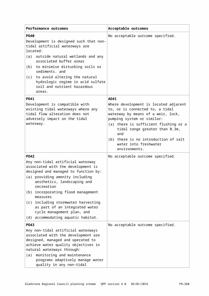
Botanical name Common name Height metres
Spread metres
Endemic Y/N
Street trees
MyrtleBackhousia myrtifolia Sweet Carro / Grey
Myrtle 4 2 Y
Baeckea spp. Various Sizes YBaeckea spp.(suggested B. la petite, camphorate, virgata mt tozer)
Various Sizes
Baeckea virgata miniature 3 3Banksia aemula Old Man Banksia 5 3 YBanksia ericifolia Heath Banksia 4 4 NBanksia integrifolia* Coastal Banksia 6 4 Y
Banksia oblongifolia 2 2 YBanksia robur Swamp Banksia 2 2 YBanksia serrata Saw Banksia 5 6Banksia spinulosia Honeysuckle Banksia 3 2 YBanksia spp. Various Sizes YBarklya syringifolia Crown of Gold 8 5Bauera rubiodes Wiry Dog Rose 1 1Bauera ruby glow 1 1Brachychiton acerifolius Flame Tree 8 4 Y
Brachychiton discolour Queensland Lace Bark 6 3 Y
Brachyscome spp. River Daisies 0.5 0.5Buckinghamia celcissima Ivory Curl 6 4
Caldcluvia paniculosa Rose Leaf Marara 8 6 NCallicarpa pedunculata Velvet Leaf 4 2 YCallicoma serratifolia Black Wattle 4 4 YCallistemon little john 1 1Callistemon spp. Various Sizes Y
Callistemon spp. (Allocasuarina spp.) (suggested C. anzac, captain cook, candy pink, dawson river, endeavour, formosis, pachyphyllus, pink champagne, salignus, viminalis, wildfire)
Various Sizes Y
Callitris columellaris Bribie Island Pine 8 4 YCalophyllum inophyllum Beauty Leaf 10 7Carpobrotus glaucescens Pigface 0.3 1 YCassia brewsteri Leichardt Bean 8 4
Castanospermum australe Black Bean 10 6 Y
Castanospora alphandii Brown Tamarind 10 5 NCasuarina cunninghamiana River She–Oak 12 6 YCasuarina spp.(suggested C. glauca, littoralis, cunninghamia,
Various Sizes Y
Gladstone Regional Council planning scheme QPP version 4.0 05/01/2016 P9—360
Botanical name Common name Height metres
Spread metres
Endemic Y/N
Street trees
torulosa)Casuarina equisetifolia* Horsetail She–Oak 6 6 YCasuarina glauca Swamp Oak 8 3 YCinnamomum oliveri Oliver's sassafras 10 6 YCissus antarctica Kangaroo Vine Vine YClerodendrum floribundum Lolly Bush 3 2 YClerodendrum inerme Scrambling
Clerodendrum 3 2 Y
Clivia miniataCommersonia bartramii Brown Kurrajong 6 3 YCordyline spp. Various Sizes YCorymbia citriodora Spotted GumCorrea reflexaCorymbia intermedia Pink Bloodwood 8 4 YCrinum pedunculatum Spider Lily / Crinum
Lily 1 1 Y
Crowea exalta Small Crowea 1 1Cryptocarya glaucescens Laurel 8 4 YCryptocarya spp. Laurel Various Sizes YCryptocarya McDonaldii Brown Beech 10 4 YCryptocarya triplinervis Brown Laurel 8 4 YCupaniopsis anacardioides Tuckeroo / Cupania 6 6 Y
Cupaniopsis spp. Tuckeroo / Cupania 6 4 YCyathea cooperi Tree Fern 4 3 YCymbopogon ambiguus Lemon Scented
Grass 1 1
Cymbopogon refractus Barbed Wire Grass 1 1 YDampiera hederacea 0.3 1Dampiera purpureaDampiera stricta 0.3 0.5 YDanthonia racemosa Wallaby Grass 1 1Darlingia darlingiana Brown Silky Oak 10 4 NDarwinia spp.(suggested D. fraserianum, muelleri)
0.5 1
Davallia pyxidata Fleur Lily 0.5 0.5 YDavidsonia pruriens Davidson Plum 8 3Dianella caerulea Flax Lily 0.5 0.3Dianthus hybridsDicanthium sericeum Queensland Blue
Grass 0.5 0.5
Dietes robinsonianaDiploglottis australis Native Tamarind 10 6 NDiploglottis campbelli Small Leaved
Tamarind 10 6 N
Dysoxylum spp.(suggested D. fraserianum,
Rosewood 10 6 Y
Gladstone Regional Council planning scheme QPP version 4.0 05/01/2016 P9—361
Botanical name Common name Height metres
Spread metres
Endemic Y/N
Street trees
muellen)Echinopogon ovatus Hedgehog GrassElaeocarpus kirtonii Blueberry Ash 8 3 NElaeocarpus grandis Blue Quandong 35 10 YElaeocarpus obovatus Blueberry Ash 10 6 YElaeocarpus reticulatus Blueberry Ash 8 6 YElaeocarpus sp.(suggested E. angustifolius, eumundi, grandis, obovatus, reticulatis)
Quandongs
Various Sizes Y
Elaeocarpus spp. Various Sizes YEndiandra discolour Tickwood 7 3 YEndiandra sieberi Corkwood 10 4 YEndiandra spp.Suggested E. discolour, globosa, sieberi)
Walnut12 4 Y
Eucalyptus crebra Narrow Leaf Grey Ironbark
Eucalyptus major Grey GumEucalyptus robusta Swamp Mahogany 10 5 YEucalyptus racemosa Scribbly Gum 8 5 NEucalyptus tereticornis Forest Red Gum/
Queensland Blue Gum
10 to 15 5 to 6 Y
Corymbia tessellaris* Moreton Bay Ash 10 6 YEugenia reinwardtiana* Beach Cherry 2 1 YEuroschinus falcatus* Ribbonwood 12 6 YFicus obliqua Small Leaved Fig 15 5 YFicus rubiginosa Small Leaved
Moreton Bay Fig 10 4 Y
Ficus spp.(including sandpaperfigs but excluding F. elastica)
Fig TreesVarious Sizes Y
Flindersia australis Crows Ash / Australian Teak 30 4 Y
Flindersia collina Leopard Wood 8 4 NFlindersia schottiana Bumpy Ash 12 3 YGeissis benthami Red Carabeen 8 4Glochidion ferdinandii Cheese Fig 8 5 YGmelina leichardtii White Beech 12 6 YGoodenia spp. 0.3 1 YGraptophyllum excelsum Scarlet Fuschia 2 1Grevillea lanigera – dwarfGrevillea baileyana White Oak 8 4Grevillea bronze rambler 0.3 3Grevillea forest rambler 0.3 3Grevillea hilliana Yiel yiel 8 5 YGrevillea robusta Silky Oak 15 N
Gladstone Regional Council planning scheme QPP version 4.0 05/01/2016 P9—362
Botanical name Common name Height metres
Spread metres
Endemic Y/N
Street trees
Grevillea royal mantle 0.3 3Grevillea spp. Various Sizes YGrevillea spp.(suggested shrubs – G.banksii, coastal glow, honey gem, majestic, moonlight, orange marmalade, pink surprise, Sandra Gordon and trees – G. baileyana, hilliana, robusta)
Various Sizes
Hardenbergia violacea Native Sarsparilla Vine YHarpullia pendula Tulipwood 6 4 YHibbertia scandens Snake Vine / Guinea
Flower 0.2 2.5 Y
Hibbertia spp.Hibbertia vestita 0.3 0.5 YHibiscus tiliaceus Cottonwood 6 6 YHoya australis Wax Flower Vine YHymenosporum flavum Native Frangipani 8 3 YIndigofera australisIpomea pes–caprae* Goats Foot Creeper 0.3 3Jacksonia scoparia Dogwood /Native
Broom 4 6 Y
Jagera pseudorhus Foambark Tree 6 3 Y
Lagerostroemia indicaLavandula angustifoliaLeptospermum cardwell Cardwell Tea Tree 2 2Leptospermum polygalifoliium
Tea Tree 3 2 Y
Leptospermum neglectum Coast Tea Tree 4 2Leptospermum petersonii Lemon Scented Tea
Tree 4 2 Y
Leptospermum Pacific Beauty Various Sizes Y
Licuala ramsayi Fan Palm 8 3 YLinospadix monostachya Walking Stick PalmLivistonia australis Cabbage Tree PalmLivistonia decipiens Weeping Cabbage
Plam 8 3
Livistonia decora Cabbage Tree Palm 10 to 12 3 to 4 YLobelia membranacea 0.3 0.5 YLomandra confertifolia 0.3 1 YLomandra histrix Mat Rush 1 1 YLomandra longifolia Mat Rush 1 1 YLophostemon confertus Brush Box 10 to 23 6 Y
Macadamia spp. Various SizesMacaranga tanarius Macaranga 4 4 Y
Gladstone Regional Council planning scheme QPP version 4.0 05/01/2016 P9—363
Botanical name Common name Height metres
Spread metres
Endemic Y/N
Street trees
Mallotus discolour Yellow Kamala 6 4 YMallotus philipensis Red Kamala YMelaleuca bracteata Revolution Gold and
Green 7 5 Y
Melaleuca erubescens Swamp Tea Tree (Qld) 4 3
Melaleuca linariifolia Snow in Summer 4 3 YMelaleuca linariifolia "snowstorm" 2 2
Melalecua nodosa Prickly Leaf Paperbark 3 2.5 Y
Melaleuca quinquenervia Broadleaved Paperbark 8 to 10 3 to 4 Y
Melaleuca sieberi Swamp Tea Tree (NSW) 6 3 N
Melaleuca spp. Various Sizes YMelaleuca stypheloides Prickly Leaf
Paperbark 6 3 Y
Melaleuca viridiflora Red Flowering Paperbark /Broad Leaved Paperbark
6 4
Melia azedarach White Cedar 8 4 YMelicope elleryana Pink Euodia 6 4 Y
Metrosideros spp.Metrosideros thompsonii New Zealand
Christmas Bush 6 4
Myoporum ellipticum 0.5 3 YMyoporum ellipticumNauclea orientalis Leichardt Tree 8 6 Y
Neolitsea dealbata White Bolly Gum 8 4 YOmalanthus populifolius Bleeding Heart 5 3 YOmolanthus populifolius Native Bleeding Heart 8 6 YOrthosiphon aristatus Cats Whiskers 2 1Pandanus tectorius* Pandanus 8 4 YParachidendron priunsom Snow Wood 6 4 YPeperomia tetraphylla 0.3 1Petalostigma pubescens Quinine Bush 5 4 YPhaleria clerodendrum(Poisonous fruit)
Scented Daphne 4 4
Phebalium woombye Woombye 2 2 YPhebalium woombye prostate form 0.3 1 Y
Pilidiostigma glabra Plum Myrtle 3Pilidostigma rhytisperma Small Leaved Plum
Myrtle 2 1 N
Pittosporum rhombifolium White Holly 6 2 Y
Pittosporum spp. Various Sizes Y
Gladstone Regional Council planning scheme QPP version 4.0 05/01/2016 P9—364
Botanical name Common name Height metres
Spread metres
Endemic Y/N
Street trees
Pittosporum undulatum Mock Orange 6 4 NPlumbago auriculataPoa australis 0.5 0.5Poa labillardierii Tussock Grass 1 1Podocarpus elatus Plum Pine / Brown
Pine 10 5 Y
Polyscias elegans Celerywood 6 2 YPolyscias murrayi Pencil Cedar 4 NPongamia pinnata 6 4
Proiphys cunninghamii Brisbane Lily 0.5 0.5 YPtychosperma elegans Solitaire PalmPultenea stutzeri Hard Alder 4 3 YPultenea spp. Various Sizes YPultenea spp.(suggested P.villose, wallum gold)
1 1 Y
Randia spp.(suggested P. chartacea, fitzalanii)
Various Sizes Y
Baloskion tetraphyllum Foxtails 1 0.5 YRhodosphaera rhodanthema Deep Yellow Wood 8 4 NRicinocarpus pinifolius prostrate form
Wedding Bush 0.3 2 Y
Scaevola spp.Scaevola spp.(Suggested S. aemula, albide, calendulaceae, purple clusters)
0.3 1
Scleranthus biflorusSloanea woollsii Yellow Carabeen 6 3 YSmilax australis Austral sarsparilla
/Barbed Wire Vine Y
Sowerbaea juncea Vanilla Lily 0.3 0.5 YStenocarpus sinuatus Firewheel Tree 10 4 N
Stipa verticillata Slender Bambo Grass 0.3 YSterelitzia reginae Bird of ParadiseStylidium graminifoliumSyncarpia glomulifera Turpentine 8 3 YSyzygium francissii Francis' Water Gum 6 4 YSyzygium australe Scrub Cherry (sth
form) 6 4 Y
Syzygium fibrosum Fibrous Satinash 4 3syzygium leuhmanii Small Leaved Lilly
Pilly 6 4 Y
Syzygium oleosum Blue Lilly Pilly 6 4 Y
Syzygium paniculatumSyzygium spp. Various Sizes Y
Gladstone Regional Council planning scheme QPP version 4.0 05/01/2016 P9—365
Botanical name Common name Height metres
Spread metres
Endemic Y/N
Street trees
Tecomanthe hillii Fraser Island Creepervine 0.5 Vine N
Tecomanthe spp. Roaring meg 0.3 Vine
Terminalia sericocarpa Damson Tree 10 5Tetratheca thymofolia Black–eyed Susan 0.5 0.5 NThemeda triandra Kangeroo Grass 1 1.5 YMelastoma malabathricum Dwarf Lasiandra 1 1Toona australis Red Cedar 12 6 YTristaniopsis laurina Water Gum 7 3 NViola hederacea Native Violet 0.3 1 YVitex ovata (compact) Beach Vitex 0.5 2Waterhousia floribunda Weeping Lilly Pilly 8 4 Y
Waterhousia unipunctatum Roly Poly Satinash 5 3Westringia fruiticosa Coastal Rosemary 2 2Xanthorrhoea spp. Grass Trees 2 1 YXanthostemon chrysanthus Golden Penda 4 2 N
Gladstone Regional Council planning scheme QPP version 4.0 05/01/2016 P9—366
9.3.5[9.3.6] Operational works9.3.5.1[9.3.6.1] ApplicationThis code applies to assessing all development within the Gladstone Regional Council area.
9.3.5.2[9.3.6.2] Purpose(1) The purpose of the Operational Works code is to:
(a) Ensure all operational works (earthworks) are undertaken to appropriate levels and standard.(b) Maintain a high standard of environmental amenity.(c) Protect surface water and ground water.
(2) The purpose of the code will be achieved through the following overall outcomes:(a) Operational works involving filling and excavation does not impact adversely on the site or
the surrounding area in terms of the physical services and the environment or social values.(b) The use of fill material that is safe and uncontaminated.(c) Maintain the amenity of adjoining land, particularly the visual amenity of residential land.(d) Operational works are located in areas that do not result in increased flooding and drainage
problems on upstream and downstream property.(e) Works are undertaken such that soil erosion is properly controlled to avoid unacceptable
increased erosion and sediment loads into watercourses.
9.3.5.3[9.3.6.3] Assessment criteriaTable 9.3.5.3.1—Criteria for assessable development
Performance outcomes Acceptable outcomes
EarthworksPO1Earthworks are undertaken in a manner that:(a) produces stable landforms and structures(b) maintains natural landforms(c) minimises height of retaining walls and batter
faces(d) does not unduly impact on the amenity or
privacy for occupants of the site or on adjoining land, and
(e) does not unduly impact on the amenity of the streetscape.
AO1.1Earthworks and retaining walls comply with the Engineering Design Planning Scheme Policy.
AO1.2Retaining walls are certified by a Registered Professional Engineer of Queensland.
AO1.3The extent of filling or excavation with a depth of 200mm or greater does not exceed 40% of the site.
AO1.4Excavating or filling is no greater than 1m, and height or depth and the combined height of retaining walls and fences does not exceed 2m.
AO1.5Soil to be used for filling if stockpiled for more than 1 month is stabilised and grassed.
AO1.6Retaining walls are set back from any boundary and are stepped or terraced so that landscaping can soften the visual impact.
PO2Earthworks maintain the efficiency of the road network and do not adversely impact upon residents or road infrastructure, including not creating any difficulty for access to the site.
No acceptable outcome is nominated.
Gladstone Regional Council planning scheme QPP version 4.0 05/01/2016 P9—367
Performance outcomes Acceptable outcomes
PO3Earthworks do not result in the contamination of land or water, and avoids risk to people and property.
AO3No contaminated material or acid sulfate soil is used as fill.
PO4Earthworks do not generate a dust nuisance.
No acceptable outcome is nominated.
Bridge and culvert workPO5Bridges and culverts for flood immunity minimise traffic disruption, improve public safety, consider fauna habitat movement and allow for bikeways during and after construction.
No acceptable outcome is nominated.
Road designPO6Roads providing access to the site are provided, constructed and maintained to a standard which is adequate for the traffic type and volume likely to be generated by the activities on site.
AO6External road works are provided in accordance with the requirements of the Engineering Design Planning Scheme Policy.
Erosion and sediment controlPO7Earthworks do not create or worsen any flooding, drainage issues, ponding or an increase in flow directions or volumes, on the site or adjoining or nearby sites to ensure that:(uuuu)[(wwww)] environmental values and water
quality objectives of receiving waters within or downstream of the proposal are protected or enhanced during the construction, operation and maintenance phases, and
(vvvv)[(xxxx)] The release of sediment–laden stormwater for all land disturbances is minimised through the use of all reasonable and practicable erosion and sediment control measures with degraded areas reinstated.
AO7Earthworks comply with flooding, drainage and erosion sediment control requirements of the Engineering design planning scheme policy.
Gladstone Regional Council planning scheme QPP version 4.0 05/01/2016 P9—368
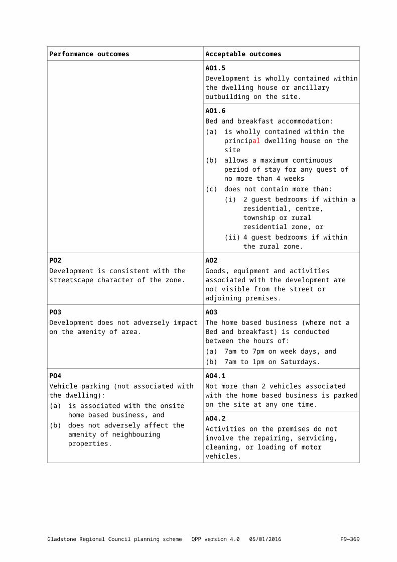
Performance outcomes Acceptable outcomes
PO8Construction activities for the development avoid or minimise adverse impacts on stormwater quality.
AO8The release of sediment–laden stormwater is avoided for the nominated design storm, and minimised when the nominated design storm is exceeded, by addressing design objectives listed below in Table 9.3.5.3.2 (construction phase) or local equivalent, for:(wwww)[(yyyy)] drainage control(xxxx)[(zzzz)] erosion control(yyyy)[(aaaaa)] sediment control, and(zzzz)[(bbbbb)] water quality outcomes.Note—An Erosion and Sediment Control Plan (ESCP) is prepared by a suitably qualified person that demonstrates:
erosion and sediment control practices (including any proprietary erosion and sediment control products) are designed, installed, constructed, operated, monitored and maintained, and any other erosion and sediment control practices are carried out in accordance with local conditions; or
how stormwater quality will be managed in accordance with an acceptable regional or local guideline so that target contaminants are treated to a design objective at least equivalent to this Acceptable outcome.
PO9Progressive rehabilitation of disturbed areas within the site is undertaken, as part of the completion of each stage of development, or where there are no stages, prior to the issuing of certificates of classification for building work or certificates of completion for operational work.
No acceptable outcome is nominated.
PO10Development provides for a comprehensive rehabilitation program which ensures that disturbed areas are stabilised, temporarily and long term, within reasonable timeframes to minimise erosion on site and sediment discharge from the site.
AO10Development provides the following:(a) Erosion control is undertaken in a staged
manner, such that disturbed areas are exposed for 30 days or less, in accordance with the Engineering Design Planning Scheme Policy
(b) Grading and reshaping of the disturbed areas to provide controlled and stable drainage flow paths
(c) High velocity flows are diverted away from disturbed areas, and
(d) The site is long term stabilised by preparing the site for planting, re–spreading stored topsoil stripped from the site or new topsoil, planting the disturbed area with native species of grasses, ground covers and trees, and placing mulch.
PO11Premises in rural areas adopt a comprehensive approach to soil erosion and sedimentation management by:(aaaaa)[(ccccc)] avoiding land clearing or
earthworks in the riparian corridor to a designated stream
No acceptable outcome is nominated.
Gladstone Regional Council planning scheme QPP version 4.0 05/01/2016 P9—369
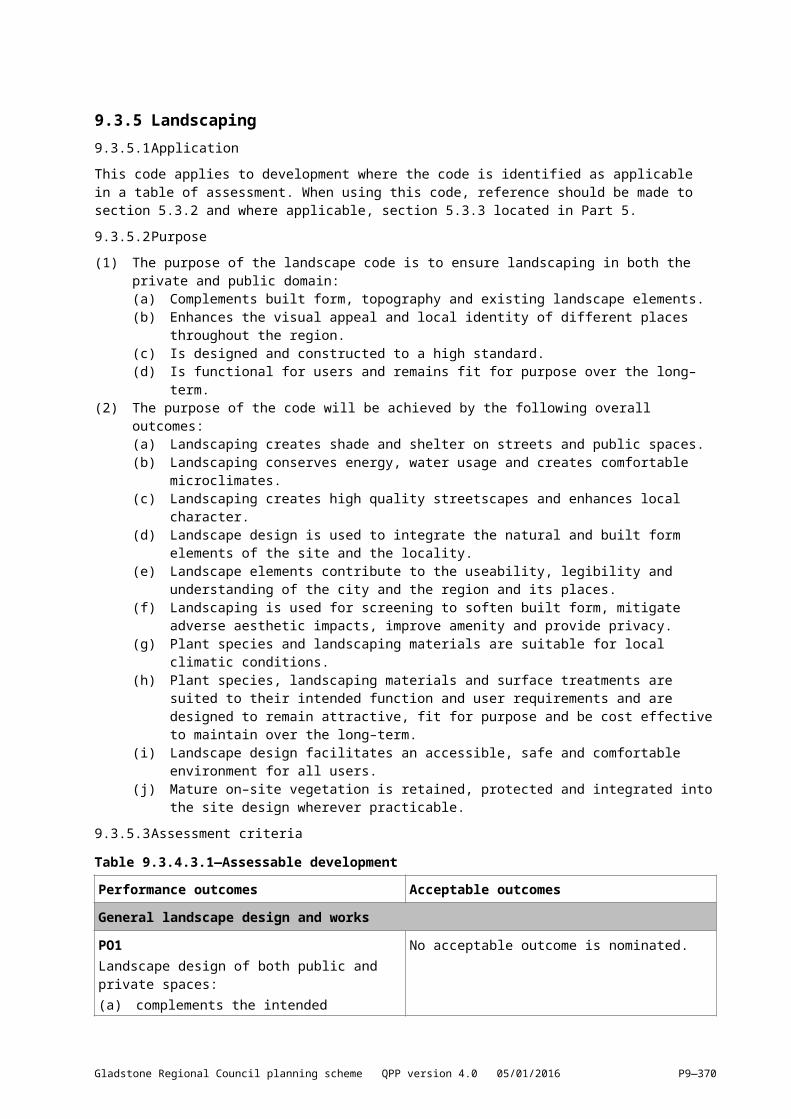
Performance outcomes Acceptable outcomes
(bbbbb)[(ddddd)] avoiding land clearing and earthworks on land with a slope steeper than 15%
(ccccc)[(eeeee)] minimising the extent of disturbance on, or the stabilisation of slopes steeper than 10% (or 1:10)
(ddddd)[(fffff)] managing and controlling surface drainage by using natural flow paths
(eeeee)[(ggggg)] rehabilitating disturbed areas as soon as practical after completion of works by re–establishing the vegetation including seeding with native grasses, ground covers and trees and spreading mulch over the surface, and
(fffff)[(hhhhh)] constructing ponds or small dams off natural flow paths, for collection of surface drainage from areas disturbed for prolonged periods, such as depots, quarries, and stock sales yards.
Weed controlPO12Weed control practices and plant and equipment cleaning and inspection protocols are:(ggggg)[(iiiii)] implemented to avoid the introduction
and spread of weeds along transport routes and delivery points, and
(hhhhh)[(jjjjj)] undertaken to control existing declared weeds and pest animals prior to the commencement of and during works.
AO12Reasonable steps have been taken to ensure that the vehicle or ‘thing’ being moved by road is free of reproductive material of any Class 1, 2 or 3 declared weeds. For example, compliance with the Queensland Guideline for Limiting Weed Seed Spread (DNR 2000).
Amenity, acoustic and air qualityPO13Development is planned, designed and managed to ensure emissions and odours from activities achieve the appropriate air quality and noise objectives (measured at the receptor).Note—These levels are in accordance with the Environmental Protection (Air) Policy 2008, and Environmental Protection (Noise) Policy 2008.
AO13No acceptable outcome is nominated.
PO14Development does not generate vibration from activities that will affect the amenity of surrounding land uses.
AO14The development does not result in vibration impacts outside of the development site.
LightingPO15External lighting is provided in urban areas to ensure a safe environment.
AO15Technical parameters, design, installation, operation and maintenance of outdoor lighting comply with the requirements of AS4282 – Control of the Obtrusive Effects of Outdoor Lighting.
PO16Outdoor lighting does not cause undue disturbance to any person, activity or fauna because of
AO16The vertical illumination resulting from direct, reflected or other incidental light coming from a site
Gladstone Regional Council planning scheme QPP version 4.0 05/01/2016 P9—370
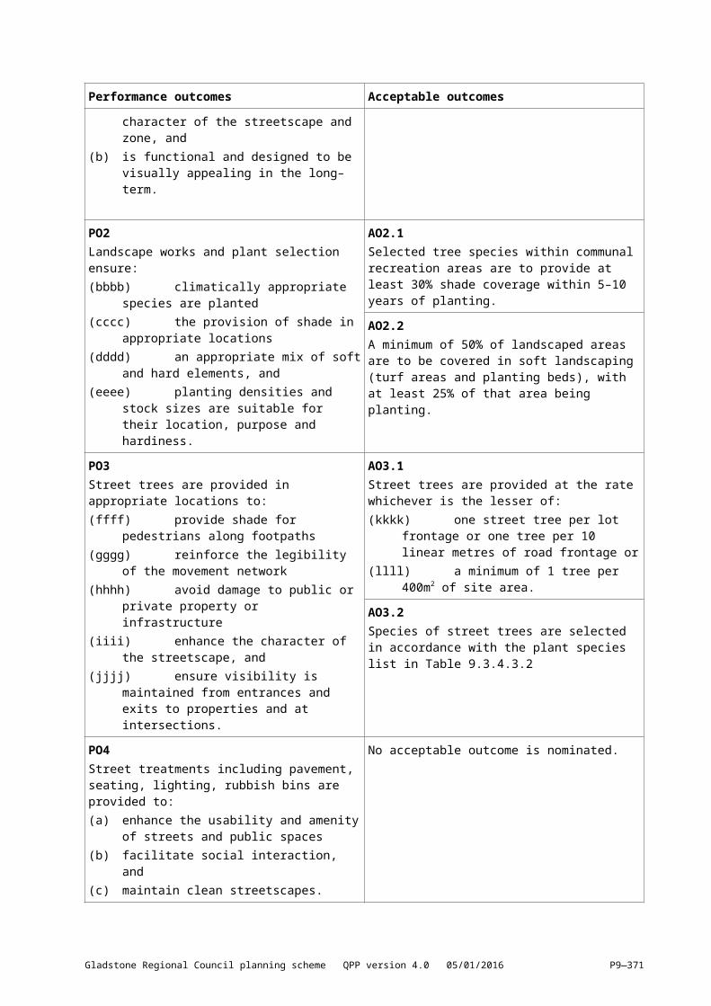
Performance outcomes Acceptable outcomes
emission, either directly or by reflection. does not exceed 8 lux when measured at any point 1.5m outside of the boundary of the property at any level from ground level up.
Operational works and electricity infrastructurePO17The excavation, filling or laying of pipes within the vicinity of electricity supply infrastructure will not create potential damage or hazard.Note—Development involving filling, or excavation or laying of metal pipes on land contiguous to electricity supply infrastructure should be referred to the relevant electricity entity for safety advice on the proposed development.
AO17.1Excavation of filling does not occur within:(iiiii)[(kkkkk)] 10m of any tower, pole, foundation,
ground anchorage or stay supporting electric lines or associated equipment
(jjjjj)[(lllll)] 5m of a substation site boundary(kkkkk)[(mmmmm)] 2m of a padmount substation,
or(lllll)[(nnnnn)] 1m of a padmount transformer or an
underground cable.
AO17.2The laying of metal pipes does not occur within:(mmmmm)[(ooooo)] 5m of any pole, tower,
foundation, ground anchorage or stay supporting electric lines or associated equipment
(nnnnn)[(ppppp)] 15m of any substation site boundary, or
(ooooo)[(qqqqq)] 5m of, and parallel to, an electric line shadow.
Table 9.3.5.3.2—Construction phase: Stormwater management design objectives
Issue Design objectivesDrainage control Temporary drainage
works(ppppp)[(rrrrr)] Design life and design storm for
temporary drainage works:(i) disturbed area open for <12 months—1 in
2–year ARI event(ii) disturbed area open for 12–24 months—1
in 5–year ARI event(iii) disturbed area open for >24 months—1 in
10–year ARI event(qqqqq)[(sssss)] design capacity excludes minimum
150mm freeboard(rrrrr)[(ttttt)] temporary culvert crossing – minimum 1 in
1–year ARI hydraulic capacity.
Erosion control Erosion control measures
(sssss)[(uuuuu)] Minimise exposure of disturbed soils at any time
(ttttt)[(vvvvv)] divert water run–off from undisturbed areas around disturbed areas
(uuuuu)[(wwwww)] determine the erosion risk rating using local rainfall erosivity, rainfall depth, soil–loss rate or other acceptable methods
(vvvvv)[(xxxxx)] implement erosion control methods corresponding to identified erosion risk rating.
Sediment control Sediment control measuresDesign storm for
(wwwww)[(yyyyy)] Determine appropriate sediment control measures using:
Gladstone Regional Council planning scheme QPP version 4.0 05/01/2016 P9—371
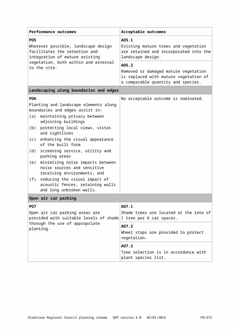
Issue Design objectivessediment control basinsSediment basin dewatering
(i) potential soil loss rate, or(ii) monthly erosivity, or(iii) average monthly rainfall
(xxxxx)[(zzzzz)] collect and drain stormwater from disturbed soils to sediment basin for design storm event:(i) design storm for sediment basin sizing is
80th% five–day event or similar(yyyyy)[(aaaaaa)] site discharge during sediment basin
dewatering:(i) TSS < 50 mg/L TSS, and(ii) turbidity not >10% receiving waters
turbidity, and(iii) pH 6.5–8.5.
Water quality Litter and other waste, hydrocarbons and other contaminants
(zzzzz)[(bbbbbb)] Avoid wind–blown litter; remove gross pollutants
(aaaaaa)[(cccccc)] ensure there is no visible oil or grease sheen on released waters
(bbbbbb)[(dddddd)] dispose of waste containing contaminants at authorised facilities.
Waterway stability and flood flow management
Changes to the natural waterway hydraulics and hydrology
For peak flow for the 1–year and 100–year ARI event, use constructed sediment basins to attenuate the discharge rate of stormwater from the site.
Gladstone Regional Council planning scheme QPP version 4.0 05/01/2016 P9—372
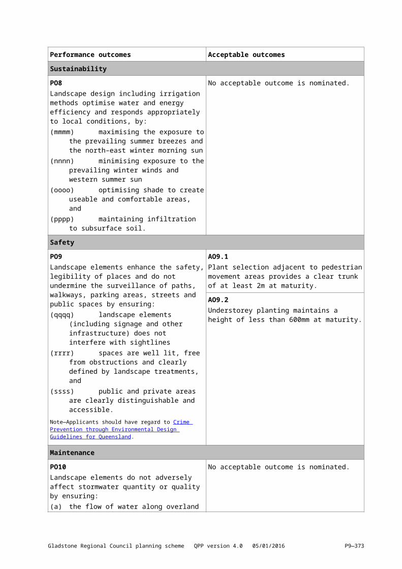
9.3.6[9.3.7] Reconfiguring a lot9.3.6.1[9.3.7.1] ApplicationThis code applies to assessing reconfiguring a lot development other than reconfiguring one lot into two to which the state wide code – Reconfiguring a lot (subdividing one into two lots) and associated operational work code applies. When using this code, reference should be made to section 5.3.2 and where applicable, section 5.3.3 located in Part 5.
9.3.6.2[9.3.7.2] Purpose(1) The purpose of the reconfiguring a lot code is to:
(a) Ensure that new lots are configured in a manner that facilitates the achievement of the sustainable urban and rural outcomes expressed in the relevant zone codes.
(b) Ensure that new lots are provided with infrastructure and access appropriate for their intended use.
(c) Minimise adverse environmental impacts and protect the landscape character of Gladstone’s natural resources.
(2) The purpose of the code will be achieved through the following overall outcomes::(a) New lots are of a size and shape appropriate for their intended use and the character of the
applicable zone.(b) New lot reconfiguration is responsive to topography, natural drainage systems, vegetation
and habitat corridors and protects the landscape character of the locality.(c) Lots ensure the amenity of and minimise impacts on adjoining land.(d) Each new lot is provided with a suitable level of infrastructure, services and access.(e) New neighbourhood development is characterised by walkability, housing choice and
conveniently located centres providing enhanced opportunities for social interaction.(f) Neighbourhoods are designed to allow development to incorporate climate responsive,
energy efficient design principles.(g) Streets are legible, safe, highly interconnected and designed to achieve enhanced
streetscapes.(h) Rural areas are not fragmented to the detriment of productive grazing, agricultural or other
rural uses.(i) Open space meets the active and passive recreational needs of the community and protects
the biodiversity of natural areas and systems.Note—In order to demonstrate compliance with this code, Council may request the preparation of a Plan of development for the locality, which may include land external to the site. This is likely where the proposed development involves more than 5 lots or the construction of a new road. The Plan of development should be prepared in accordance with the provisions of this code in conjunction with SC6.3 Plans of development particularly in regard to the development of New Neighbourhoods in the Emerging community zone. Plan of development may form the basis of a preliminary approval for development in an area.
Gladstone Regional Council planning scheme QPP version 4.0 05/01/2016 P9—373
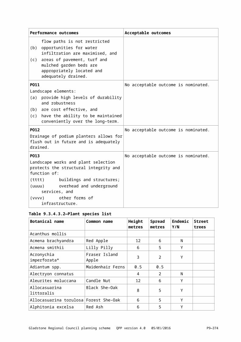
9.3.6.3[9.3.7.3] Criteria for assessmentTable 9.3.7.3.1—For assessable development
Performance outcomes Acceptable outcomes
Lot designPO1Reconfiguration creates lots that are of a sufficient size, shape and dimension:(a) that are consistent with the character of the
zone(b) to accommodate development
commensurate with the required building footprint, setbacks, private open space, vehicle access and parking and servicing areas for the zone
(c) that does not compromise the future development potential of land in the emerging community zone for urban purposes, and
(d) are sufficient to protect areas with significant ecological values.
AO1Lots comply with the minimum lot size and dimensions specified for its zone in Table 9.3.6.3.2—Minimum lot size and dimensions.
PO2Rear lots are only created where:(cccccc)[(eeeeee)] they are for the purpose of a
single dwelling house(dddddd)[(ffffff)] the topography of the land or other
physical features ensure that the amenity of adjoining lots would not be detrimentally affected
(eeeeee)[(gggggg)] the circumstances of the particular case are such that it would not be desirable or practical to provide full frontage lots
(ffffff)[(hhhhhh)] the safety of the frontage road is not adversely affected (including for waste collection), and
(gggggg)[(iiiiii)] the access handle has sufficient width to provide vehicular access and services to the rear lot.
AO2.1Only 1 rear lot is provided behind each full frontage lot.
AO2.2The number of adjoining rear lots does not exceed 2 and not more than 4 lots directly adjoin a rear lot (excluding lots that adjoin at one point).
AO2.3The minimum size of a rear lot, excluding its access handle is:(hhhhhh)[(jjjjjj)] the same as the minimum lot size
for the relevant zone in accordance with Table 9.3.6.3.2—Minimum lot size and dimensions, and
(iiiiii)[(kkkkkk)] is capable of containing a building envelope having minimum dimensions of 15m x 20m.
AO2.4The access handle of the rear allotment has a minimum width of 4m.
PO3Any boundary realignment must:(jjjjjj)[(llllll)] improve the shape or utility of the
existing lot(kkkkkk)[(mmmmmm)] be consistent with the
character of the zone, and(llllll)[(nnnnnn)] not create additional lots.
AO3.1No additional lots are created.
AO3.2The realignment meets the minimum lot size and dimensions in accordance with Table 9.3.6.3.2—Minimum lot size and dimensions.
PO4Any boundary realignment that is resolving a
No acceptable outcome is nominated.
Gladstone Regional Council planning scheme QPP version 4.0 05/01/2016 P9—374
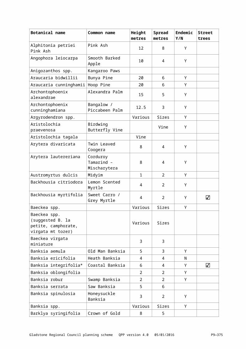
Performance outcomes Acceptable outcomes
building encroachment must:(mmmmmm)[(oooooo)] be an improvement on the
existing situation, and(nnnnnn)[(pppppp)] not create a situation where, as
a result of the reconfiguration the building/s become unlawful.
General designPO5The layout of lots, streets and infrastructure avoids or minimises impacts on environmental features by:(a) following the natural topography and
minimising earthworks(b) avoiding crossing or otherwise fragmenting
waterways, wetlands, habitat areas, ecological corridors or steep land, and
(c) maintaining natural drainage features and hydrological regimes.
No acceptable outcome is nominated.
PO6Reconfiguration is designed to ensure integration with the surrounding locality, having regard to:(oooooo)[(qqqqqq)] connections to surrounding
streets, pedestrian and cycle networks and other infrastructure networks
(pppppp)[(rrrrrr)] open space networks, habitat areas or corridors
(qqqqqq)[(ssssss)] connections to centres, employment areas and recreation areas
(rrrrrr)[(tttttt)] surrounding landscaping and streetscape treatments, and
(ssssss)[(uuuuuu)] the interface between adjoining land uses.
No acceptable outcome is nominated.
Neighbourhood design in residential zones (Note: This also applies to Plans of development in the Emerging community zone)PO7Reconfigurations are designed to ensure:(a) the creation of seamless interlinked
neighbourhoods with residential character and identity
(b) pedestrian movement is encouraged, and(c) neighbourhoods are concentrated around
community focus points such as neighbourhood centres and parks.
No acceptable outcome is nominated.
PO8A variety of lot sizes are provided in close proximity to neighbourhood centres and parks to promote a wider housing choice and mix that is consistent with zone outcomes.
No acceptable outcome is nominated.
PO9Neighbourhood design provides for safer communities by maximising opportunities for casual surveillance and minimising opportunities for crime
No acceptable outcome is nominated.
Gladstone Regional Council planning scheme QPP version 4.0 05/01/2016 P9—375
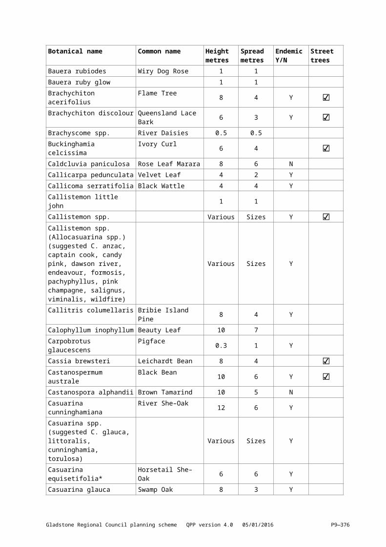
Performance outcomes Acceptable outcomes
and vandalism.Note—Applicants may find useful guidance in the Queensland Government’s Crime Prevention through Environmental Design Guidelines for Queensland.
PO10Movement and open space networks are:(a) safe, clearly legible and have a high degree
of connectivity, and(b) interconnected through a grid or modified
grid pattern.
AO10.1Street blocks have a maximum length of 200m and depth of 80m.
AO10.2Where street blocks have a length in excess of 150m a mid–block pedestrian link not less than 5m wide is provided to encourage walkability.
AO10.3Collector roads linking neighbourhoods are provided on a grid of not less than 800m.
PO11Movement networks prioritise walking, cycling and public transport within neighbourhoods.
AO11Ninety percent of all dwellings are within 400m walking distance of an existing or planned public transport stop, park and or community facility.
PO12The permeability and connectivity of streets is not compromised by the use of cul–de–sacs unless no alternative arrangement is possible.
No acceptable outcome is nominated.
Climate responsive designPO13Neighbourhood layouts are designed to respond to local climate conditions and enable energy efficient dwellings.
AO13Streets are generally configured to run in a north–south direction between 30o east and 20o west of true north or an east–west direction between 20o north and 30o south of east.
PO14Smaller or wider lots are located as north facing lots and larger or narrower lots are located as south facing lots.
No acceptable outcome is nominated.
Lot reconfiguration in industrial zonesPO15Reconfiguration includes a range of lot sizes to facilitate industrial activities applicable to the zone.
No acceptable outcome is nominated.
PO16Reconfiguration maximises access to any railway, transport route, intermodal terminal or sea port.
No acceptable outcome is nominated.
PO17Where reconfiguration adjoins land in another zone, lots are of a sufficient size to mitigate any noise, air quality and visual impacts on that adjoining land.
No acceptable outcome is nominated.
Lot reconfiguration in the Rural zonePO18Reconfiguration:(a) maintains rural, open space and landscape
No acceptable outcome is nominated.
Gladstone Regional Council planning scheme QPP version 4.0 05/01/2016 P9—376
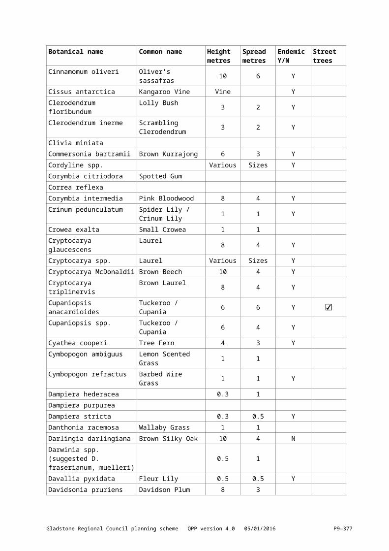
Performance outcomes Acceptable outcomes
character(b) protect the productive capacity of rural land
resources, and(c) allows for the efficient operation of rural
activities.
PO19Reconfiguration of land identified as Agricultural land Class A and B does not:(tttttt)[(vvvvvv)] adversely impact on the viability of
land for agricultural or grazing purposes, and(uuuuuu)[(wwwwww)] constrain existing farming
activities.Note—Class A and B agricultural land is identified in the Agricultural land classification overlay map.
AO19Fragmentation of land designated as Agricultural land Class A or B does not occur in the Rural zone.
Infrastructure and servicesNote—Refer also to the Development design code.
PO20Each reconfigured lot is provided with infrastructure and services appropriate to its intended use and location in a manner that:(vvvvvv)[(xxxxxx)] is efficient(wwwwww)[(yyyyyy)] is adaptable to allow for future
infrastructure upgrades(xxxxxx)[(zzzzzz)] minimises risk of adverse
environmental or amenity–related impacts(yyyyyy)[(aaaaaaa)] promotes the efficient use of
water resources, and(zzzzzz)[(bbbbbbb)] minimises whole of life cycle
costs for that infrastructure.
AO20.1Lots created within a designated Priority Infrastructure Plan area for a reticulated water supply and/or a reticulated sewerage supply, are connected to that supply in accordance with the Engineering design planning scheme policy.
AO20.2Lots created include stormwater infrastructure in accordance with the design requirements of the Engineering design planning scheme policy.
AO20.3Lots are connected to electricity and telecommunications infrastructure in accordance with the standards of the relevant regulatory authority prior to the commencement of any use of the site.
AO20.4Electricity and telecommunications infrastructure is provided underground where the reconfiguration occurs in an urban area and exceeds 5 new lots.
PO21Where reconfiguration proposes individual on–site waste water disposal, it must be demonstrated that:(aaaaaaa)[(ccccccc)] the soil type and permeability,
slope, and hydrology of the land is capable of accommodating the proposed loads within the lot, and
(bbbbbbb)[(ddddddd)] individually and collectively, the impacts of the existing and proposed systems do not adversely impact on the groundwater quality of the locality.
No acceptable outcome is nominated.
Gladstone Regional Council planning scheme QPP version 4.0 05/01/2016 P9—377
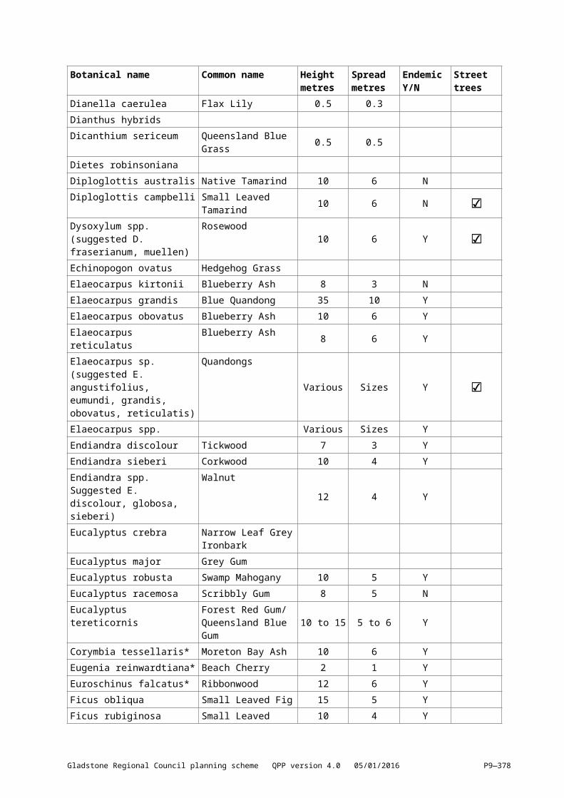
Performance outcomes Acceptable outcomes
Access and road designNote—Refer also to the Development design code.
PO22Lots have safe access for vehicles and pedestrians through:(ccccccc)[(eeeeeee)] direct frontage to a properly
constructed public road or to common property having a direct frontage to a properly constructed public road created under a community management statement, and
(ddddddd)[(fffffff)] providing access appropriate for the type of vehicle associated with development.
AO22Lots are designed to achieve safe vehicle and pedestrian access in accordance with the Engineering design planning scheme policy.
PO23Reconfiguration involving the creation of new roads must:(eeeeeee)[(ggggggg)] provide for the safe, efficient
and convenient movement for all modes of transport
(fffffff)[(hhhhhhh)] are designed and constructed to support their intended function for all relevant design vehicle types
(ggggggg)[(iiiiiii)] provide safe and easy access to the frontage of lots
(hhhhhhh)[(jjjjjjj)] are designed and constructed to give priority to pedestrian and bicycle pathways at intersections
(iiiiiii)[(kkkkkkk)] where practicable, facilitate the provision of an integrated public transport system within 400m of lots
(jjjjjjj)[(lllllll)] where practicable, align with open space corridors and waterways, and
(kkkkkkk)[(mmmmmmm)] where appropriate provide connections to adjoining land.
No acceptable outcome is nominated.
Gladstone Regional Council planning scheme QPP version 4.0 05/01/2016 P9—378
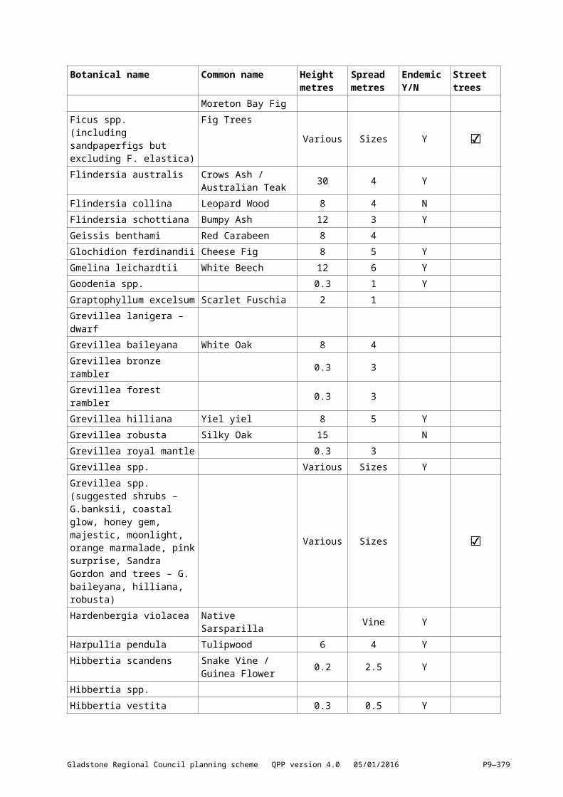
Performance outcomes Acceptable outcomes
PO24New roads include streetscape and landscape treatments that:(lllllll)[(nnnnnnn)] create an attractive and legible
environment which establishes character and identity
(mmmmmmm)[(ooooooo)] maintain important views and vistas where possible
(nnnnnnn)[(ppppppp)] enhance safety and comfort, and meet user needs
(ooooooo)[(qqqqqqq)] complement the function of the street in which they are located by reinforcing desired traffic speed and behaviour
(ppppppp)[(rrrrrrr)] support safe pedestrian and cycling movement
(qqqqqqq)[(sssssss)] maximise infiltration of stormwater runoff wherever practicable, and
(rrrrrrr)[(ttttttt)] minimise maintenance and whole of lifecycle costs.
No acceptable outcome is nominated.
PO25Rear lanes:(sssssss)[(uuuuuuu)] provide appropriate width to
enable safe vehicle movement, including service vehicles
(ttttttt)[(vvvvvvv)] connect to other streets at both ends
(uuuuuuu)[(wwwwwww)] enable safe access into and out of garages
(vvvvvvv)[(xxxxxxx)] avoid a direct through–route alternative for vehicles, cyclists or pedestrians than the adjoining street network
(wwwwwww)[(yyyyyyy)] ensure rear yards of properties can be fenced for security, and
(xxxxxxx)[(zzzzzzz)] do not provide for visitor parking within the lane.
Note— Applicants should have regard to Crime Prevention through Environmental Design Guidelines for Queensland.
AO25Rear lanes are designed in accordance with the Engineering design planning scheme policy.
Note— In accordance with Councils road hierarchy, rear lanes are to be constructed as access lanes.
Pedestrian and cycle infrastructureNote—Refer also to the Development design code.
PO26Reconfiguration includes appropriate pedestrian and cycle infrastructure that:(yyyyyyy)[(aaaaaaaa)] provides a high level of
connectivity and permeability that links residential areas with schools; centres, community activity uses; parks, employment areas and public transport stops
(zzzzzzz)[(bbbbbbbb)] provides for safe street crossings and for safety between pedestrians and cyclists
(aaaaaaaa)[(cccccccc)] is designed taking into
No acceptable outcome is nominated.
Gladstone Regional Council planning scheme QPP version 4.0 05/01/2016 P9—379
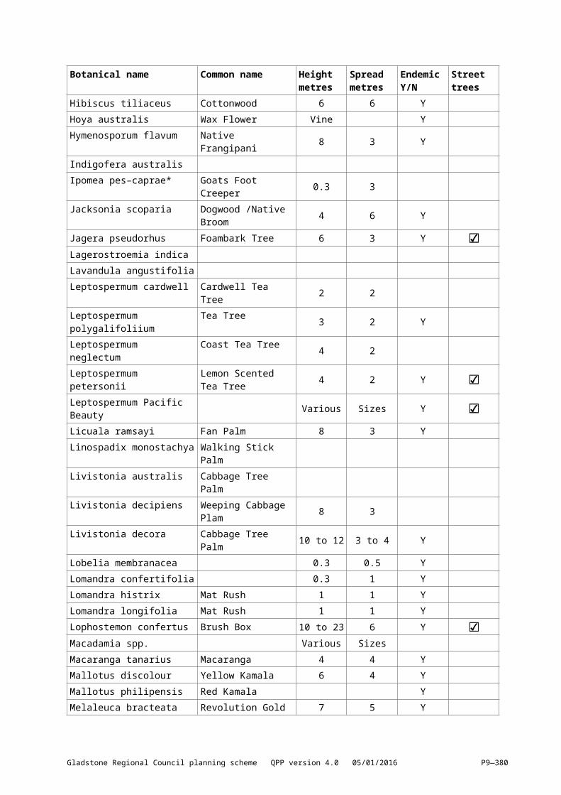
Performance outcomes Acceptable outcomes
account topography and convenience for users, and
(bbbbbbbb)[(dddddddd)] meets disability access standards.
Stormwater managementNote—Refer also to the Development design code.
PO27Reconfiguring a lot development:(cccccccc)[(eeeeeeee)] manages the stormwater
quality, quantity and velocity flow characteristics from the lot to maintain or improve the pre–development levels, and
(dddddddd)[(ffffffff)] where practicable incorporates stormwater re–use.
No acceptable outcome is nominated.
Parks and open spaceNote—Where acceptable outcomes are set out in this section, it is acknowledged that they may only be practicable in greenfield developments. Alternative outcomes are likely to be appropriate in existing developed areas. This may include works and embellishment to existing parks or recreational corridors to meet the development’s demand, or as part of an infrastructure agreement.
PO28Reconfiguring a lot provides parkland or open space which:(a) meets the needs of the community for a
range of active and passive uses, and(b) is of a sufficient size and shape to
accommodate recreation activities with associated equipment and facilities.
AO28Parkland is provided in accordance with the Local Government Infrastructure Plan.
PO29The design of parkland or open space:(eeeeeeee)[(gggggggg)] contributes to the
character of the neighbourhood or area(ffffffff)[(hhhhhhhh)] is safe and functions as a focal
point for the neighbourhood or community(gggggggg)[(iiiiiiii)] minimises the interface between
residential lots and open space through appropriate treatments including alignment, fencing and landscaping
(hhhhhhhh)[(jjjjjjjj)] maximises road frontage to facilitate casual surveillance
(iiiiiiii)[(kkkkkkkk)] incorporates natural areas including important local vegetation, waterways, ridgelines, coastal access, wetlands
(jjjjjjjj)[(llllllll)] preserves landscape features important to the scenic amenity of a locality
(kkkkkkkk)[(mmmmmmmm)] is linked to existing parkland or open space networks wherever possible
(llllllll)[(nnnnnnnn)] offers a broad range of informal and formal experiences to the community
(mmmmmmmm)[(oooooooo)] is cost effective to
No acceptable outcome is nominated.
Gladstone Regional Council planning scheme QPP version 4.0 05/01/2016 P9—380
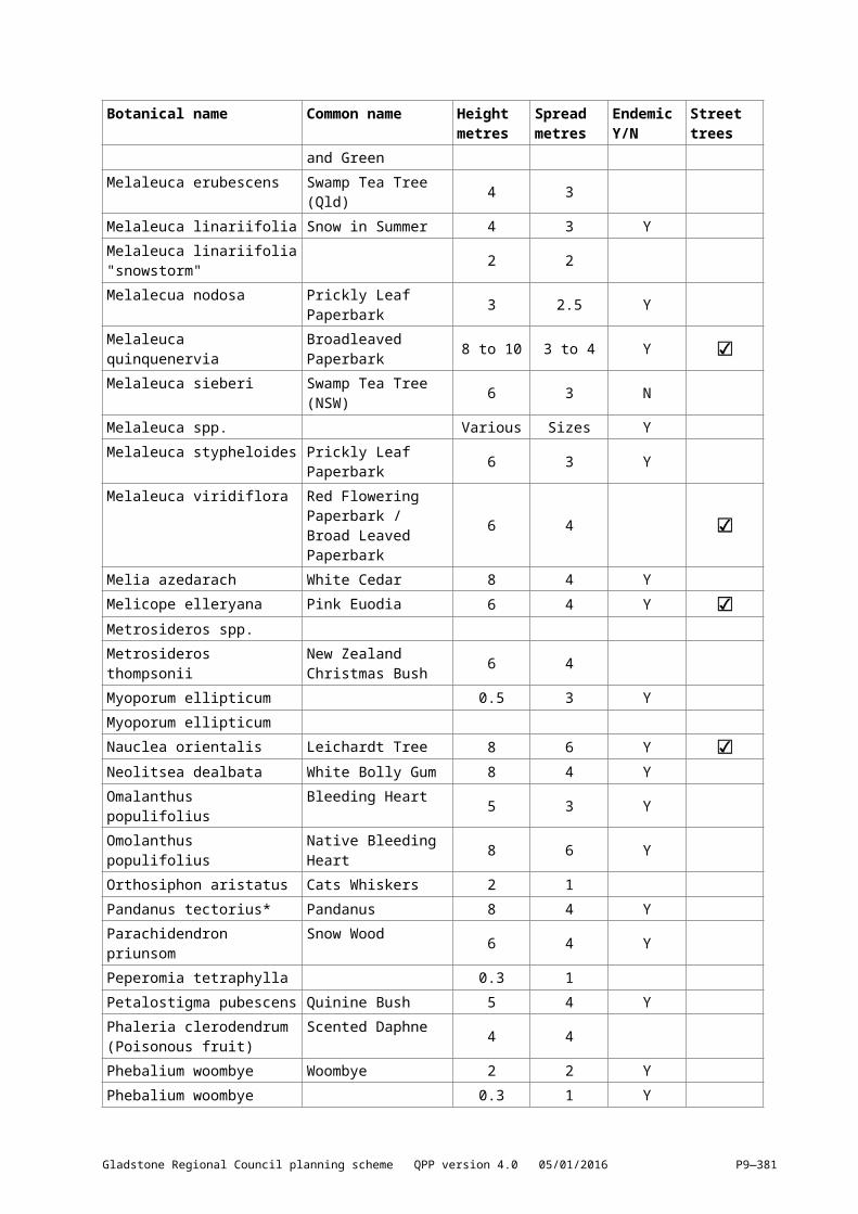
Performance outcomes Acceptable outcomes
maintain, and(nnnnnnnn)[(pppppppp)] is provided in the early
stages of staged developments.
PO30The location of parkland or open space is conveniently located to residential neighbourhoods.
AO30Parkland is provided within 400m of all residential dwellings.
PO31Open space for conservation purposes protects riparian corridors, beach front vegetation, endangered plant communities and wildlife habitat and movement corridors.
No acceptable outcome is nominated.
Volumetric reconfigurationPO32Volumetric reconfiguration (subdivision of space above or below the surface of land):(oooooooo)[(qqqqqqqq)] facilitates efficient
development that is consistent with the intent for the zone, or
(pppppppp)[(rrrrrrrr)] is consistent with a development approval.
No acceptable outcome is nominated.
Access easementPO33The access easement must:(qqqqqqqq)[(ssssssss)] be of adequate width(rrrrrrrr)[(tttttttt)] be constructed to a standard
appropriate to the situation, and(ssssssss)[(uuuuuuuu)] not result in unreasonable
detriment or nuisance to neighbours.
AO33The access easement is designed in accordance with the design requirements of the Engineering design planning scheme policy.
Community title subdivisionsPO34Community title subdivisions are only supported in instances where:(a) reticulated services are unavailable or
limited;(b) land is constrained by natural hazards; or(c) land has high value scenic amenity or
biodiversity value.Note—Community title subdivisions are not supported in any other instance.
AO34No acceptable outcome is nominated.
Table 9.3.7.3.2—Minimum lot size and dimensions
Column 1Zone
Column 2Minimum lot size
Column 3Minimum frontage
Low density residential 600m2; or800m2 if in the Calliope neighbourhood precinct
17m
Low–medium density residential 400m2; or 10m; or
Gladstone Regional Council planning scheme QPP version 4.0 05/01/2016 P9—381
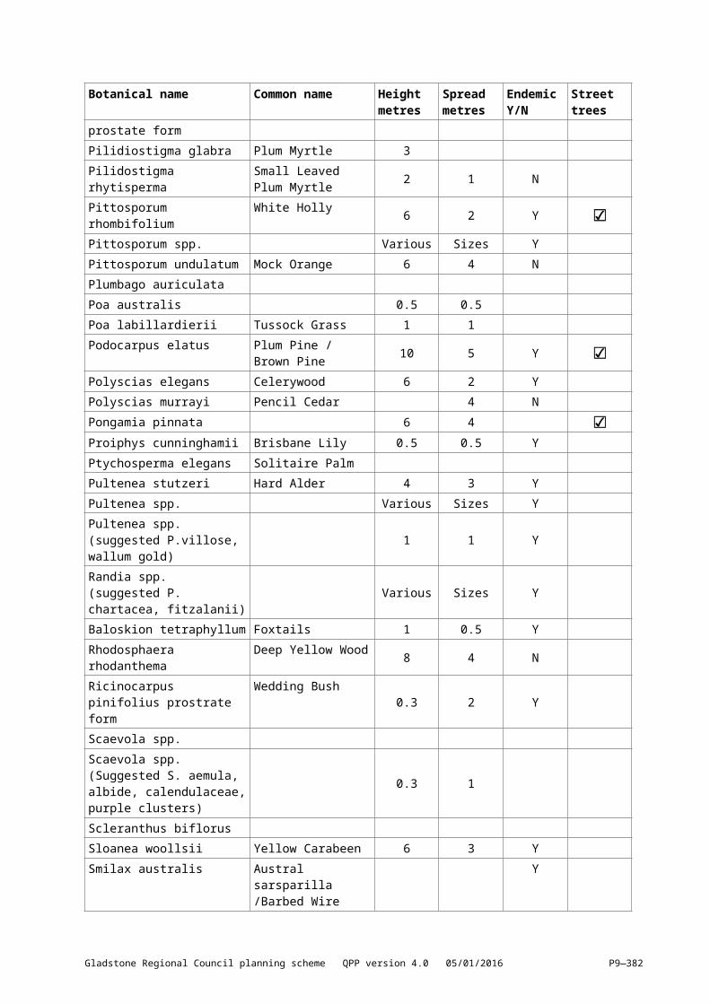
Column 1Zone
Column 2Minimum lot size
Column 3Minimum frontage
Medium density residential 1,000m2 where in the Beaches village circuit precinct
30m where in the Beaches village circuit precinct
Character residential Not specified Not specified
Mixed usePrincipal centreCentre
600m2 15m
Neighbourhood centre 400m2 15m
Specialised centre 1,000m2 15m
Township 800m2 where unsewered, subject to capability of the site to sustainably dispose of effluent on site
20m
Sport and recreation Not specified Not specified
Open space Not specified Not specified
Conservation Not specified Not specified
Low impact industry 1,000m2 20m
Medium impact industry 4,000m2 40m
Special industry Not specified Not specified
Industry investigation 50ha Not specified
Community facilities Not specified Not specified
Environmental management Not specified Not specified
Limited development (constrained land)
50ha where in the Flood affected lands precinct
Not specified
250ha where in the Major industry buffer precinct
Rural zone 250ha 300m
Rural residential 6,000m2 (where lots are provided with full service reticulated water supply)
40m
1.5ha (in all other circumstances including the Beecher/Burua constant flow precinct)
Emerging community 50ha Not specified
Major tourism 2ha 40m
Minor tourism 600m2 15m
Special purpose Not specified Not specified
Gladstone Regional Council planning scheme QPP version 4.0 05/01/2016 P9—382
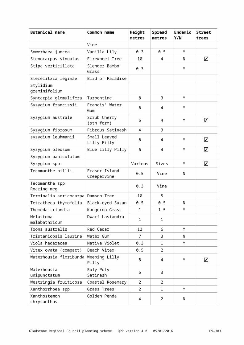
9.3.7[9.3.8] Telecommunications facility use9.3.7.1[9.3.8.1] ApplicationThis code applies to a material change of use for telecommunications facilities where the code is identified as applicable in the tables of assessment. When using this code, reference should be made to section 5.3.2 and where applicable, section 5.3.3 located in Part 5.Note—Low impact telecommunications facilities are not regulated by the planning scheme. The Telecommunications (Low Impact Facilities) Determination 1997 provides a full list of low impact facilities. Low impact facilities remain the responsibility of the Commonwealth.
9.3.7.2[9.3.8.2] Purpose(1) The purpose of the telecommunications facilities use code is to ensure that telecommunication
facilities are located, designed and managed to minimise impacts on the amenity of adjoining premises.
(2) The purpose of the code will be achieved through the following overall outcomes:(a) Development does not unreasonably impact on the amenity of adjoining premises and the
zone.(b) Development facilitates co–location of infrastructure wherever possible.(c) Development does not unreasonably impact on the character and streetscape of the locality.
9.3.7.3[9.3.8.3] Assessment criteria Table 9.3.8.3.1—Criteria for self–assessable and assessable development
Performance outcomes Acceptable outcomes
For self–assessable and assessable developmentDesignPO1Development minimises visual amenity impacts on surrounding land uses.
AO1.1Development does not exceed the maximum building height for the zone.
AO1.2Where in the Rural zone, development has the following minimum setbacks from all dwellings:(tttttttt)[(vvvvvvvv)] 10m, where the height of the
structure is less than 20m(uuuuuuuu)[(wwwwwwww)] 15m, where the height
of the structure is between 20m and 30m, and
(vvvvvvvv)[(xxxxxxxx)] 20m, where the height of the structure is greater than 30m.
AO1.3Where in any zone other than the Rural zone or residential zones, development has the following minimum setbacks from all property boundaries:(wwwwwwww)[(yyyyyyyy)] 10m, where the height
of the structure is less than 20m(xxxxxxxx)[(zzzzzzzz)] 15m, where the height of
the structures is between 20m and 30m, and(yyyyyyyy)[(aaaaaaaaa)] 20m, where the height of
the structure is greater than 30m.
NoisePO2Development does not generate noise which:(zzzzzzzz)[(bbbbbbbbb)] causes nuisance, or
AO2Development provides that:(a) noise levels measured as the adjusted
maximum sound pressure level LAmax, adj.
Gladstone Regional Council planning scheme QPP version 4.0 05/01/2016 P9—383

Performance outcomes Acceptable outcomes
(aaaaaaaaa)[(ccccccccc)] exceeds ambient noise levels.
T at a noise sensitive place do not exceed:(i) background noise level plus 5dB(A)
between the hours of 7am and 10pm(ii) background noise level plus 3dB(A)
between the hours of 10pm and 7am, and
(b) noise levels measured as the adjusted maximum sound pressure level LAmax, adj. T at a business place do not exceed:(i) background noise level plus 10dB(A)
between the hours of 7am and 10pm, and
(ii) background noise level plus 8dB(A) between the hours of 10pm and 7am.
Screening and landscapingPO3Any building associated with a telecommunications facility is screened:(a) from view from any adjoining use and street,
and(b) by vegetation.
AO3.1A vegetation buffer with a minimum width of 2m surrounds the Telecommunications facility.
AO3.2All vegetation buffers must:(a) be semi–mature vegetation upon planting,
and(b) grow to a minimum height of 2m within 3
years of being planted.
SecurityPO4Fencing prevents unauthorised access to telecommunications facilities.
AO4A fence with a minimum height of 2m is provided around all buildings and structures.
Co–locationPO5Development is designed to facilitate co–location of telecommunication facilities.
AO5Development:(a) ensures the design facilitates co–masting or
co–siting with other carriers, or(b) involves co–location with an existing
telecommunications facility.
Gladstone Regional Council planning scheme QPP version 4.0 05/01/2016 P9—384
i