Embed Size (px)
Citation preview
MODULE - 7
105
Our Water ResourcesNatural Resource and theirdevelopment in India
GEOGRAPHY
Notes
21
OUR WATER RESOURCES
Water is so important for life that we can not imagine life without it. The evolutionof life itself took place in the water. In the evolution of all kinds of life, water hasplayed an important role. The amount of water found in the living beings is 65 percent and 65 to 99 percent in plants. This clearly shows the need and utility ofwater. Water which is a precious gift of the nature has several uses. Water is veryessential for the development.
From the point of view of availability and suitability, the potable water is limited inIndia. Morever, it has highly unown geographical distribution. Another disturbingissue is day by day deteriorating quality of water. It is a matter of great concern forall of us. Besides coordinating the demand and supply of the water, there is a needto keep the balance among different sources of water. Hence conservation ofwater resources is an essential requirement.
OBJECTIVES
After studying this lesson, you will be able to know different sources of water; explain the meaning of water budget; explain the uneven distribution of water; know the utility of water; understand the utility and distribution of different sources of irrigation; locate important river valley projects on the map; explain the need of the water management; explain the impact of flood and draught on the life of the people; explain the meaning of watershed development; explain the methods of conservation of water resources.
MODULE - 7
106
Our Water ResourcesNatural Resource and their
development in India
GEOGRAPHY
Notes
21.1 WATER RESOURCES
Water is the most valuable resources of nature. This is renewable and inexhaustibleresource but is in trouble these days. Demand of water has been increasingcontinuously its supply decreasing. If we look at the water resources of India inthe global contect, India has 4 percent water whereas she is housing 16 percent ofthe world’s population. It means the per capita availability of water is quite low inour country. India ranks first in the world in irrigated area. One-eighth area of thecountry is flood prone and one-sixth area is under the grip of drought. Nature ofmonsoon is mostly responsible for this. Food grains and other agricultural productsare required in large quantity for the growing population. For this reason the useof water for irrigation of crops has been increasing. The demand for water hasincreased in the cities due to rapid urbanization, industrialization, and modernization.In addition, the demand for water has been increasing for sewerage and forremoving all kinds of wastes.
21.2 SOURCES OF WATER
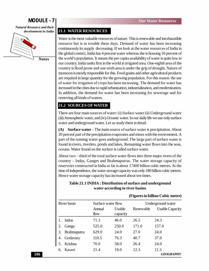
There are four main sources of water: (i) Surface water (ii) Underground water(iii) Atmospheric water, and (iv) Oceanic water. In our daily life we use only surfacewater and underground water. Let us study them in detail.(A) Surface water – The main source of surface water is precipitation. About20 percent part of the precipitation evaporates and mixes with the environment. Apart of the running water goes underground. The large part of surface water isfound in rivers, riverlets, ponds and lakes. Remaining water flows into the seas,oceans. Water found on the surface is called surface water.About two – third of the total surface water flows into three major rivers of thecountry – Indus, Ganges and Brahmaputras. The water storage capacity ofreservoirs constructed in India so far is about 17400 billion cubic metres. At thetime of independence, the water storage capacity was only 180 billion cubic metres.Hence water storage capacity has increased about ten times.
Table 21.1 INDIA : Distribution of surface and undergroundwater according to river basins
(Figures in billion Cubic metre)
River basin Surface water flow Underground waterAnnual Usable Renewable Usable Capacityflow capacity
1. Indus 71.3 46.0 26.5 24.32. Ganga 525.0 250.0 171.0 157.03. Brahmaputra 629.0 24.0 27.0 24.04. Godavary 110.5 76.3 40.7 37.05. Krishna 70.0 58.0 26.4 24.06. Kaveri 21.4 19.0 12.3 11.3
MODULE - 7
107
Our Water ResourcesNatural Resource and theirdevelopment in India
GEOGRAPHY
Notes
7. Mahanadi 68.9 50.0 16.5 15.08. Narmada 45.7 34.5 10.8 9.99. Tapi 14.9 14.5 8.3 7.610. Other rivers 365.4 11.82 74.0 68.2Total 1952.1 690.3 431.32 395.6
The storage capacity of usable water in the Ganges basin is the maximum, but inspite of maximum annual flow, the storage capacity of usable water is the least inBrahmaputras basin. The storage capacity in Godavary, Krishna, Mahanadi andIndus is sufficient. If storage capacity of usable water is seen in terms of ratio, thenTapi river basin is 97 percent. Annual water flow in the three major rivers of India– Indus, Ganga and Brahmaputras is more. Hence water storage capacity of theserivers can be increased.
(B) Underground water
Rain water percolates into the earth’s surface and becomes underground water.The process of percolation also take place from the surface water. Large amountof water gets collected under the Earth’s surface by these two methods. This iscalled underground water. According to Central Underground Water Boardrenewable underground water capacity in India (1994-95) was about 4310 billioncubic metre per year. Out of this about 3960 billion cubic metre water is availablefor use.
The distribution of undergrounds water is not the same everywhere. Availability ofunderground water depends upon the amount of rainfall, nature of rainfall, natureof land and its slope. In the areas of high rainfall where the land is almost plain andhas porous rocks, the water easily percolates there. Therefore underground wateris available in plenty at shallow depths in these areas. In the areas like Rajasthanwhere the land is plain and has porous sandy soil, the underground water is availablein lesser amount at greater depths due to lack of rainfall. In the north-eastern areasof the country, where the land is sloppy, the conditions are not suitable for percolationof water inspite of more rainfall. With the result underground water is available inless quantity at greater depths in these areas also. There are large resources ofunderground water in the plains of Ganga – Brahmaputra and in coastal plains.The availability of underground water is less in peninsular plateau, Himalayan regionand desert areas.
Use of underground water capacity
Underground water is used on a large scale in the areas where the rainfall iscomparatively less. Underground water is used on a large scale in Punjab, Haryana,Rajasthan, Tamil Nadu, Gujarat and Uttar Pradesh whereas Andhra Pradesh,Madhya Pradesh, Maharashtra, Karnatake and Chhattisgarh are such states whereinspite of less rainfall, the use of underground water is less. There is a great need todevelop underground water resources here.
MODULE - 7
108
Our Water ResourcesNatural Resource and their
development in India
GEOGRAPHY
Notes
INTEXT QUESTIONS 21.1
1. What is the main source of surface water?_______________________________________________________
2. In which river basin is usable underground water available?_______________________________________________________
3. How much part of the country comes under floods and drought every year?_______________________________________________________
21.3 WATER BUDGET
Water Budget means – the balance between the available water in the country andthe water under use. There is a great variation in the distribution of water resourcesin space and time. Water is available in sufficient quantity during rainy season. Asthe dry season sets in, there is a shortage of water. The reserves of our surface andunderground water are about 23840 billion cubic metres. Out of this only 10860billion cubic metre water is required for use.
The unit of measurement of amount of water is cubic metre or hectare metre. Ifwater standing one metre deep on a perfectly level area of one square metre, thenthe total volume of whole of that water would be one cubic metre. In the sameway, if water standing one metre deep on a perfectly level area of one hectare thenthe total volume of water would be one hectare metre.
You have already studied about the nature and distribution of rainfall in chapter17. In India, 90 percent rainfall take place during the short period of three monthsfrom june to August. There is a great variation in the number of rainy days in India.Average number of rainy days on the western coast is 137. In Rajasthan averagenumber of rainy days is reduced to less than 10. There is a variation in the natureof rainfall also. The rainfall may be heavy and continuous in the areas of morerainfall where as the rainfall may be low and intermittent in the areas of lessrainfall. Hence, there is a great variation in the regional distribution of rainfall.About 8 percent areas of the country receive more than 200 cm rainfall, 20 percentareas receive rainfall between 125 to 200 cm. and remaining 30 percent areas,receive less than 75 cm, rainfall. Uneven distribution of rainfall is responsible forthe uneven distribution of surface and underground water.
INTEXT QUESTIONS 21.2
1. Define the water budget._______________________________________________________
MODULE - 7
109
Our Water ResourcesNatural Resource and theirdevelopment in India
GEOGRAPHY
Notes
2. State the two units of measurement of water?(i) _________________________(ii)____________________________
3. In which part of the country is the duration of rainfall longest?_______________________________________________________
4. What is the proportional share of land area in the country which receivemore than 200 cm rainfall?_______________________________________________________
5. Mention the main component responsible for the uneven distribution of water.
_______________________________________________________
21.4 UTILITY OF WATER
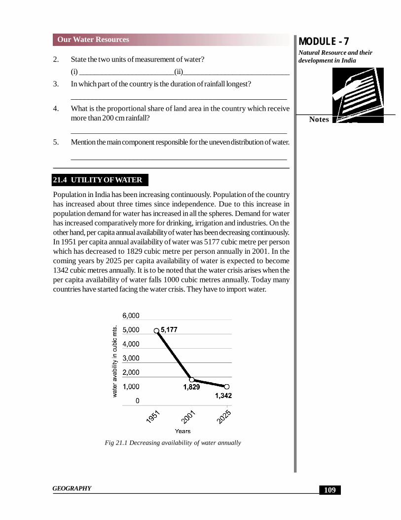
Population in India has been increasing continuously. Population of the countryhas increased about three times since independence. Due to this increase inpopulation demand for water has increased in all the spheres. Demand for waterhas increased comparatively more for drinking, irrigation and industries. On theother hand, per capita annual availability of water has been decreasing continuously.In 1951 per capita annual availability of water was 5177 cubic metre per personwhich has decreased to 1829 cubic metre per person annually in 2001. In thecoming years by 2025 per capita availability of water is expected to become1342 cubic metres annually. It is to be noted that the water crisis arises when theper capita availability of water falls 1000 cubic metres annually. Today manycountries have started facing the water crisis. They have to import water.
Fig 21.1 Decreasing availability of water annually
MODULE - 7
110
Our Water ResourcesNatural Resource and their
development in India
GEOGRAPHY
Notes
There are various uses of water. We need water for drinking, domestic use,irrigation, industries, public health, cleanliness and for flushing or draining sewageor human waste. Water is continuously needed for generation of hydro-electricity.You can not imagine fishing, forestry and water sports without great amount ofwater. In this way, water is essential for all kinds of developmental work. Its use isessential in all spheres of life. Due to rapid growth of urban population, the demandfor water in urban areas has increased tremendously.
Table 21.2 INDIA : Changing pattern of use of water 1990-2050(figures in billion cubic metre)
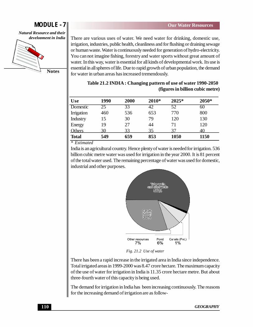
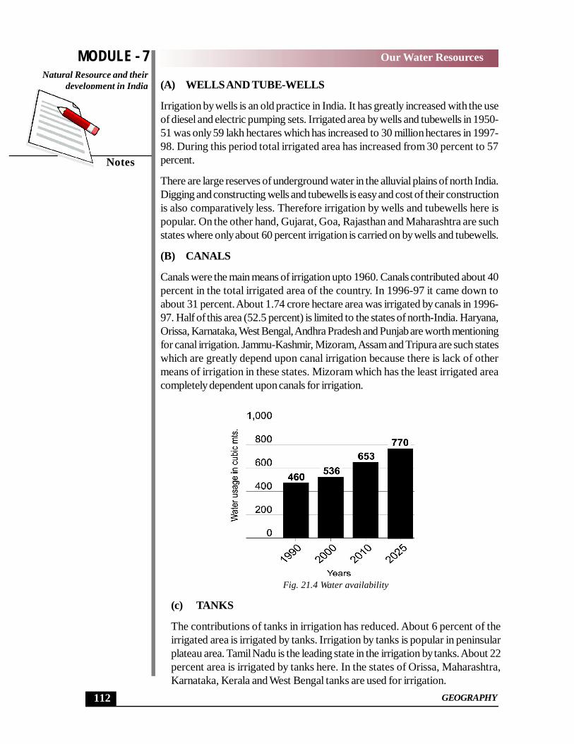
Use 1990 2000 2010* 2025* 2050*Domestic 25 33 42 52 60Irrigation 460 536 653 770 800Industry 15 30 79 120 130Energy 19 27 44 71 120Others 30 33 35 37 40Total 549 659 853 1050 1150* EstimatedIndia is an agricultural country. Hence plenty of water is needed for irrigation. 536billion cubic metre water was used for irrigation in the year 2000. It is 81 percentof the total water used. The remaining percentage of water was used for domestic,industrial and other purposes.
Fig. 21.2 Use of water
There has been a rapid increase in the irrigated area in India since independence.Total irrigated areas in 1999-2000 was 8.47 crore hectare. The maximum capacityof the use of water for irrigation in India is 11.35 crore hectare metre. But aboutthree-fourth water of this capacity is being used.
The demand for irrigation in India has been increasing continuously. The reasonsfor the increasing demand of irrigation are as follow-
MODULE - 7
111
Our Water ResourcesNatural Resource and theirdevelopment in India
GEOGRAPHY
Notes
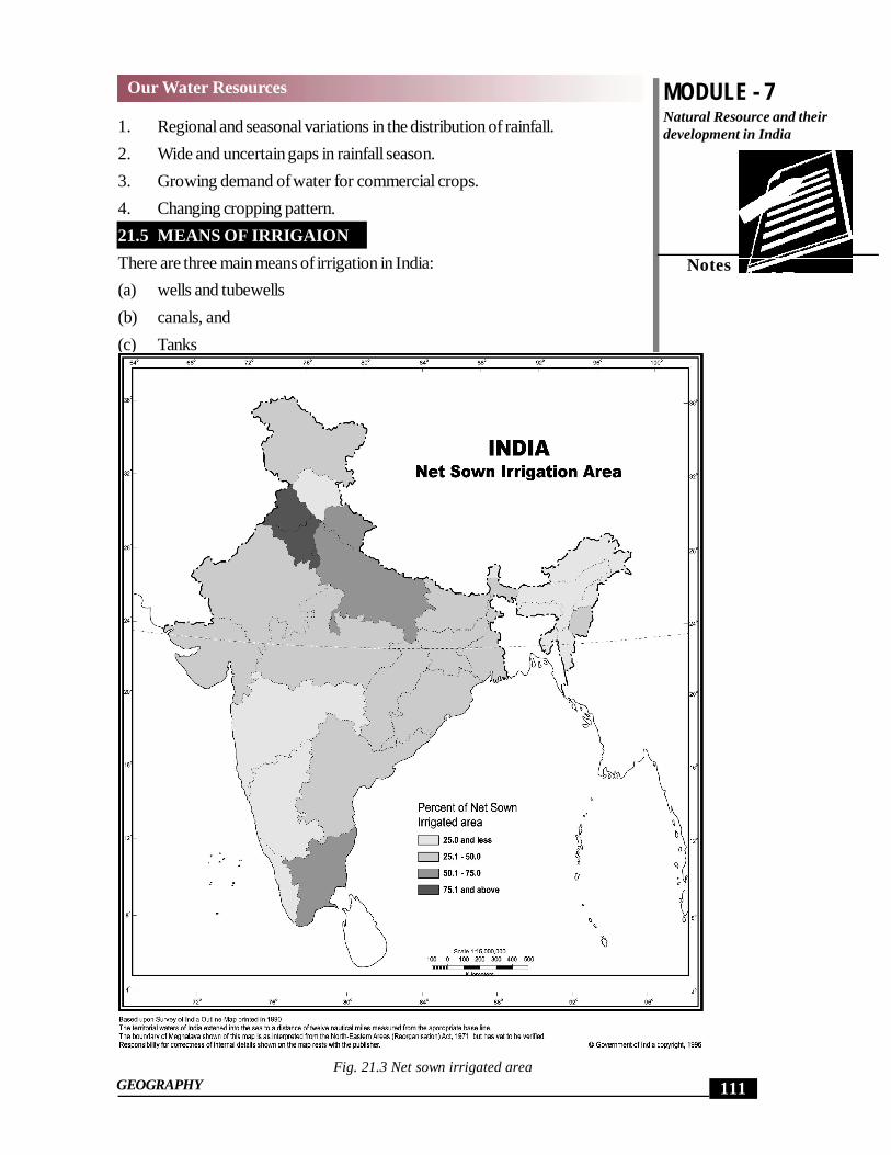
1. Regional and seasonal variations in the distribution of rainfall.2. Wide and uncertain gaps in rainfall season.3. Growing demand of water for commercial crops.4. Changing cropping pattern.21.5 MEANS OF IRRIGAIONThere are three main means of irrigation in India:(a) wells and tubewells(b) canals, and(c) Tanks
Fig. 21.3 Net sown irrigated area
MODULE - 7
112
Our Water ResourcesNatural Resource and their
development in India
GEOGRAPHY
Notes
(A) WELLS AND TUBE-WELLS
Irrigation by wells is an old practice in India. It has greatly increased with the useof diesel and electric pumping sets. Irrigated area by wells and tubewells in 1950-51 was only 59 lakh hectares which has increased to 30 million hectares in 1997-98. During this period total irrigated area has increased from 30 percent to 57percent.
There are large reserves of underground water in the alluvial plains of north India.Digging and constructing wells and tubewells is easy and cost of their constructionis also comparatively less. Therefore irrigation by wells and tubewells here ispopular. On the other hand, Gujarat, Goa, Rajasthan and Maharashtra are suchstates where only about 60 percent irrigation is carried on by wells and tubewells.
(B) CANALS
Canals were the main means of irrigation upto 1960. Canals contributed about 40percent in the total irrigated area of the country. In 1996-97 it came down toabout 31 percent. About 1.74 crore hectare area was irrigated by canals in 1996-97. Half of this area (52.5 percent) is limited to the states of north-India. Haryana,Orissa, Karnataka, West Bengal, Andhra Pradesh and Punjab are worth mentioningfor canal irrigation. Jammu-Kashmir, Mizoram, Assam and Tripura are such stateswhich are greatly depend upon canal irrigation because there is lack of othermeans of irrigation in these states. Mizoram which has the least irrigated areacompletely dependent upon canals for irrigation.
Fig. 21.4 Water availability
(c) TANKS
The contributions of tanks in irrigation has reduced. About 6 percent of theirrigated area is irrigated by tanks. Irrigation by tanks is popular in peninsularplateau area. Tamil Nadu is the leading state in the irrigation by tanks. About 22percent area is irrigated by tanks here. In the states of Orissa, Maharashtra,Karnataka, Kerala and West Bengal tanks are used for irrigation.
MODULE - 7
113
Our Water ResourcesNatural Resource and theirdevelopment in India
GEOGRAPHY
Notes
INTEXT QUESTIONS 21.3
1. How much is the per capita average annum availability of water in India?_______________________________________________________
2. When arises the water crisis?_______________________________________________________
3. Which is the main means of irrigation in India? How much percent of land isirrigated by this?_______________________________________________________
4. In which part of the country is the irrigation done mainly by tanks?
_______________________________________________________
21.6 RIVER VALLEY PROJECTS
To make India economically self sufficient and to improve the standard of living ofthe people, development efforts were initiated soon after the independence. Amongthese activities special emphasis was laid on the development of river valley projects.River valley projects were multipurpose projects. The main objectives of theseprojects are flood control, prevention of soil erosion, provision of water for irrigation,drinking and for industries, genration of electricity, transport, entertainment,conservation of wild life and development of fisheries.
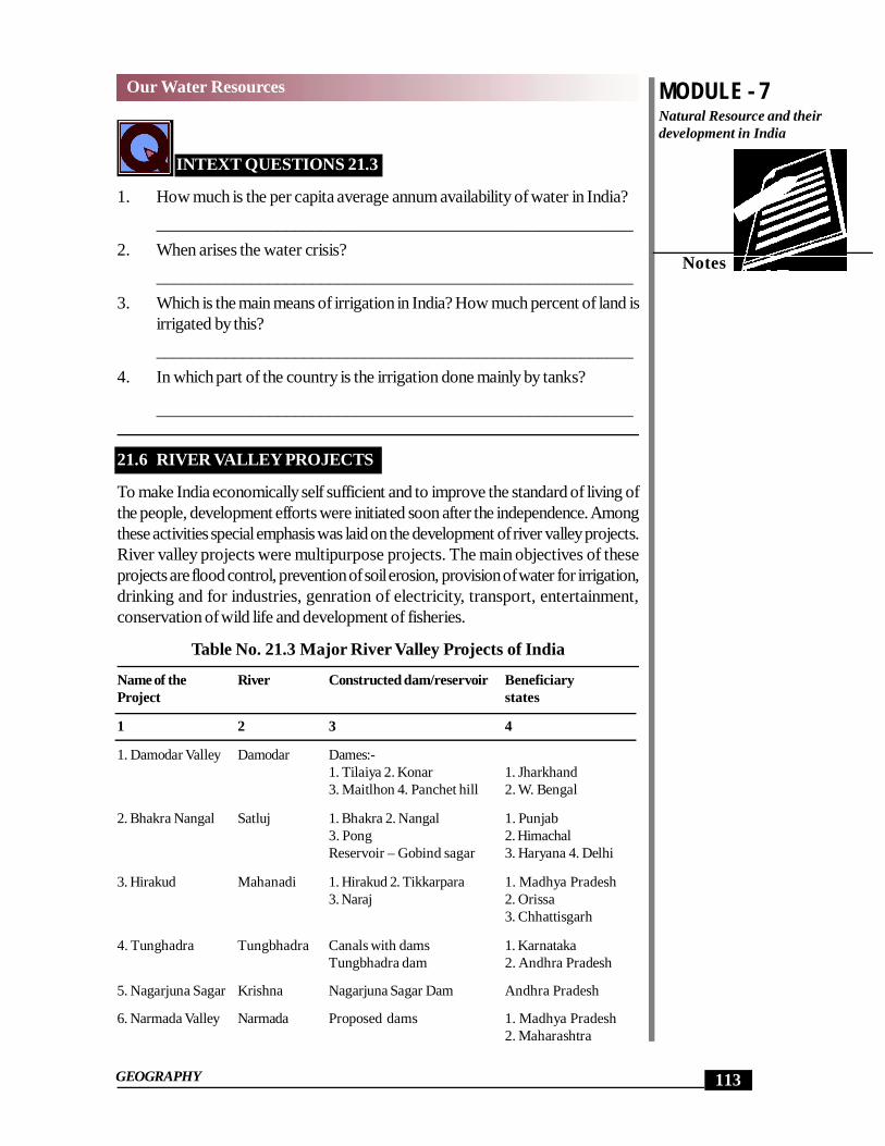
Table No. 21.3 Major River Valley Projects of India
Name of the River Constructed dam/reservoir BeneficiaryProject states
1 2 3 4
1. Damodar Valley Damodar Dames:-1. Tilaiya 2. Konar 1. Jharkhand3. Maitlhon 4. Panchet hill 2. W. Bengal
2. Bhakra Nangal Satluj 1. Bhakra 2. Nangal 1. Punjab3. Pong 2. HimachalReservoir – Gobind sagar 3. Haryana 4. Delhi
3. Hirakud Mahanadi 1. Hirakud 2. Tikkarpara 1. Madhya Pradesh3. Naraj 2. Orissa
3. Chhattisgarh
4. Tunghadra Tungbhadra Canals with dams 1. KarnatakaTungbhadra dam 2. Andhra Pradesh
5. Nagarjuna Sagar Krishna Nagarjuna Sagar Dam Andhra Pradesh
6. Narmada Valley Narmada Proposed dams 1. Madhya Pradesh2. Maharashtra
MODULE - 7
114
Our Water ResourcesNatural Resource and their
development in India
GEOGRAPHY
Notes
1. Sardar Sarovar 3. Gujarat2. Narmada Sagar 4. Rajasthan3. Burgi
7. Kosi Kosi Three units – 1. Kosi Barrage 1. Bihar2. Kosi Shaktigrah 2. Jharkhand3. Hanuman Nagar 3. Nepal
8. Chambal Valley Chambal Dams:- 1. Rajasthan1. Gandhi Sagar 2. Madhya Pradesh2. Rana Pratap Sagar3. Jawahar Sagar4. Kota Barrage
9. Indira Gandhi Beas- Dam on Ravi RajasthanCanal Satluj Beas and Satluj
Pong
21.7 RAIN WATER HARVESTING
Rain water harvesting generally means collection of rain water. Its special meaningis a technique of recharging of underground water. In this technique water is madeto go underground after collecting rain water locally, without polluting the same.With this, water during the time of scarcity local domestic demand can be met.
Now the question arises – After all why do we need water harvesting? Three mainreasons are responsible for this:-
1. Scarcity of surface water2. Growing dependence on underground water.3. Increasing urbanization.
(A) Urban Scenario – Total amount of rain water recovered in an area is called‘rain water reserve’. Effective management of rain water reserve is called ‘potentialwater harvesting’. Think for a while the area of the roof of your house is 100square metres and the ‘average rainfall’ of this area is 60 cms. Suppose the wateron the roof has neither flowed, percolated nor evaporated then there will be 60cms, high water on the roof.
Volume of water = Area of the roof X Amount of annual rainfall= 100 x 60 cms = 100 x .6 = 60 cubic metres
In other words, a family can collect 60,000 litre water in a year. All water relatedneeds of this family can be met with this. On an average a person needs 10 litrewater for drinking daily. If your family consists of 6 members, then you need6x10x365 = 21900 litres water. Remaining (60,000 – 21,900) = 38,100 litrewater can be used in dry weather when there is a scarcity of water.
(B) Rural Scenario – The tradition of water harvesting is very old in India. Butthe utility of water harvesting has never been felt so much as it is today. Even todaythe people living in the areas of water scarcity try to do their domestic work by
MODULE - 7
115
Our Water ResourcesNatural Resource and theirdevelopment in India
GEOGRAPHY
Notes
adopting old methods. Deepening and dredging of wells, tanks and ponds areincluded in these methods. Water harvesting in the small channels (locally knownas bawli) is an important traditional method in the areas of water scarcity. Now wecan be in a better and secure situation by adopting new technique of waterharvesting. Think for a while. If the people living in 5,87,000 village engagethemselves for harvesting rain water of their 2000 lakh hectare area, there will belot of water available for use. On an average a village comes under the radius of37,500 lakh cubic metre rain water reserve. By this calculation we come to knowthat there is great potential of rain water harvesting.
21.8 METHODS OF RAIN WATER HARVESTING
We can adopt different methods for rain water harvesting according to need,available facilities and environmental conditions. The following methods are worthmentioning–
1. Construction of potholes – We can harvest water in small ditchesconstructed in those areas where there is not much underground water. Theseditches may be constructed 1-2 metre wide and 2-3 metres deep. Theirshape could be anything. These ditches are filled with roubbles and sand.Rainwater can easily percolate through these.
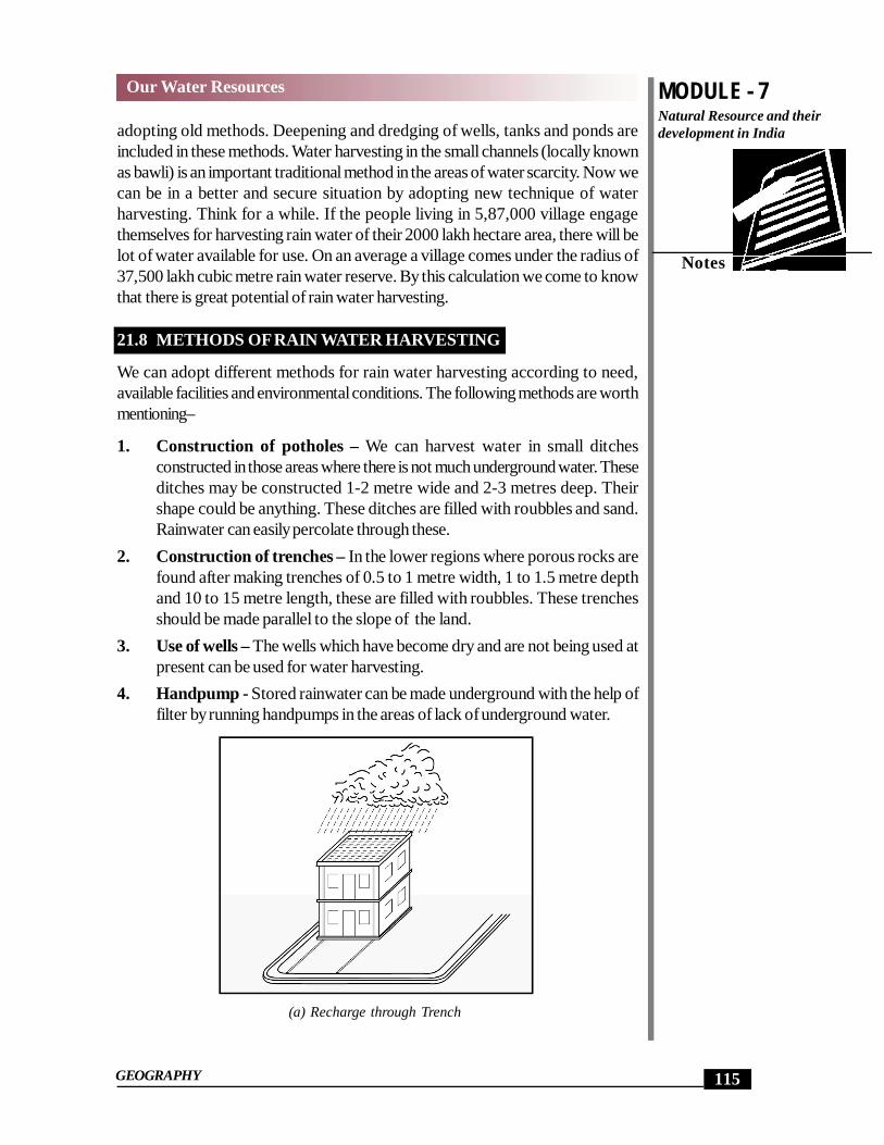
2. Construction of trenches – In the lower regions where porous rocks arefound after making trenches of 0.5 to 1 metre width, 1 to 1.5 metre depthand 10 to 15 metre length, these are filled with roubbles. These trenchesshould be made parallel to the slope of the land.
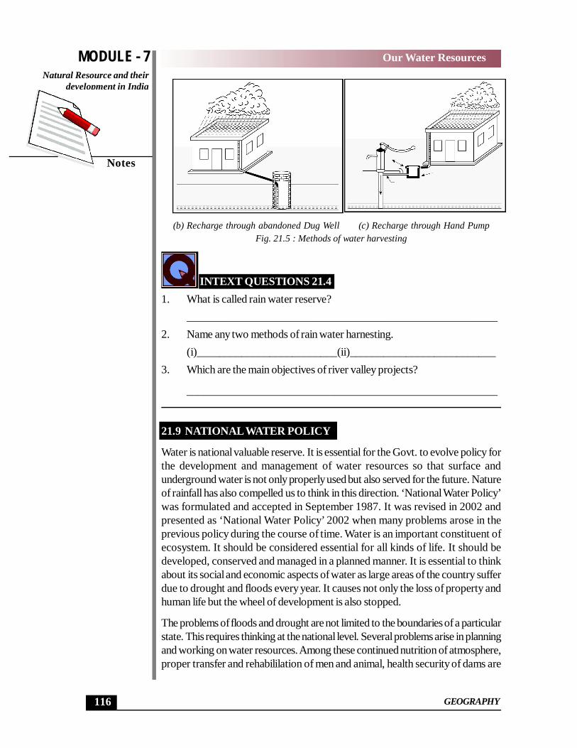
3. Use of wells – The wells which have become dry and are not being used atpresent can be used for water harvesting.
4. Handpump - Stored rainwater can be made underground with the help offilter by running handpumps in the areas of lack of underground water.
(a) Recharge through Trench
MODULE - 7
116
Our Water ResourcesNatural Resource and their
development in India
GEOGRAPHY
Notes
(b) Recharge through abandoned Dug Well (c) Recharge through Hand PumpFig. 21.5 : Methods of water harvesting
INTEXT QUESTIONS 21.41. What is called rain water reserve?
_______________________________________________________2. Name any two methods of rain water harnesting.
(i)_________________________(ii)__________________________3. Which are the main objectives of river valley projects?
_______________________________________________________
21.9 NATIONAL WATER POLICY
Water is national valuable reserve. It is essential for the Govt. to evolve policy forthe development and management of water resources so that surface andunderground water is not only properly used but also served for the future. Natureof rainfall has also compelled us to think in this direction. ‘National Water Policy’was formulated and accepted in September 1987. It was revised in 2002 andpresented as ‘National Water Policy’ 2002 when many problems arose in theprevious policy during the course of time. Water is an important constituent ofecosystem. It should be considered essential for all kinds of life. It should bedeveloped, conserved and managed in a planned manner. It is essential to thinkabout its social and economic aspects of water as large areas of the country sufferdue to drought and floods every year. It causes not only the loss of property andhuman life but the wheel of development is also stopped.
The problems of floods and drought are not limited to the boundaries of a particularstate. This requires thinking at the national level. Several problems arise in planningand working on water resources. Among these continued nutrition of atmosphere,proper transfer and rehabililation of men and animal, health security of dams are
MODULE - 7
117
Our Water ResourcesNatural Resource and theirdevelopment in India
GEOGRAPHY
Notes
such problems which can be tackled in a specific period. The problem of standingwater and salinity in the soil arise in some areas. More exploitation of undergroundwater in many areas of the country have posed serious challenge. It is essential tothink about all these problems under a general policy.
The production of food grains in the decade of 1950 was 500 lakh tons whichrose to 2080 lakh tons in 1999-2000. We have to increase the amount of foodgrains to 3500 lakh tons in 2025. The demand of water would increase in domestic,industries, energy production sectors etc. Water resources are already less, thosewill become further less in future. Quality of water is also an important aspect.Pollution of surface and underground water, has been increasing. Main sources ofwater pollution due to human activities include domestic waste water, industrialeffluents and chemicals used in agricultural. Sometimes water pollution is also causedby natural factors. Erosion, landslides, decomposition of plants and animals arethe main nature sources of water pollution. Three fourths of the total surface waterin our country is polluted.
21.10 WATERSHED DEVELOPMENT
The meaning of watershed refers to an area whose water flows towards a point.The planned use of this water can deliver better results. Related area may be avillage or a group of villages in the form of a unit. All kinds of land like agricultural,waste lands and forests may be included in this area. Maximum use of the land ispossible by adopting watershed programme; The overall development with properutilization of water in the area is considered to be watershed development.
(A) Benefits of watershed development – The following benefits can beachieved by water-shed development-1. Supply of water for drinking and irrigation.2. Increase in bio-diversity.3. Loss of acidity in the soil and free for standing water.4. Increase in the agricultural production and productivity.5. Decrease in the cutting of forests.6. Increase in the standard of living.7. Increase in employment.8. Increase in personal get together by participation of local people.
(B) The results of water shed development – Notwithstanding a huge amountof expenditure made by the Govt, (20 billions dollars by 2000) on watersheddevelopment,we have not been able to achieve desired results so far. Thefollowing factors are responsible for this:-
a. lack of scientific thinkingb. imperfect techniques
MODULE - 7
118
Our Water ResourcesNatural Resource and their
development in India
GEOGRAPHY
Notes
c. indifferent attitude of local populationd. lack of coordination among various departmental agencies, ande. absence of independent ministry.
(c) River linkages – Large areas of the country suffer from droughts andfloods. Droughts and floods are two sides of the same coin. ‘National waterDevelopment Authority’ was constituted in 1982 to solve this problem. Themain objects of its constitution was to identify only the national water network.Finally National water Development Authority identified linkage of 30 rivers.Large rivers have mainly been included in this programme. Authority hasrecommended starting of work on 6 places of river linkages and theircompletion has to be carried out in three stages.Ist STAGE - In the first stage, main peninsular rivers – Mahanadi, Godavary,Krishna and Kavery have been included.IInd STAGE - In the second stage, linking of small river basins of peninsularIndia have been recommended. Ken, Betwa and Par-Tapi reivers are includedin this.IIIrd STAGE – In the third stage there is a provision for linking tributariesof Ganga and Brahmputras with one-another.
(D) Benefits of rivers linkages – All round development of an area is possibleby joining basins. The irrigation of about 250 lakh hectare additionalagricultural area is possible by surface water after the success of thisprogramme. Underground water will be available to irrigate additionalagricultural area of about 100 lakh hectares. With the result, irrigated areawill increase from 1130 lakh hectares to 1500 lakh hectares. Additionalhydro-electricity of about 340 lakh kilowatt will be generated. Besides thesebenefits, many other benefits like flood control, water transport, water supply,fishing, removal of acidity from the soil and control on water pollution willalso be achieved. But these benefits can not easily be achieved. Much moneyand time has to be spent on these projects. According to an estimate a largesum of Rs 560 thousand crore are required to complete these projects.
21.11 METHODS OF WATER CONSERVATION
If there is no water, there is no life. Hence water conservation is essential. Futuregeneration may be in difficulty due to scarcity of water. The participation of anindividual, society and the Govt. is essential for water conservation. The followingmethods can be adopted for water conservation –
1. Dams and reserveors should be constructed on rivers so that river waterdoes not go waste into the seas and oceans.
2. The water of rivers should be saved from pollution by urban waste at allcosts.
MODULE - 7
119
Our Water ResourcesNatural Resource and theirdevelopment in India
GEOGRAPHY
Notes
3. Serious efforts should be made to control floods.4. Water should be used properly.5. Mass awakening should be around for water conservation.6. Solicit active participation of the people in all the activities related to water
conservation and efficient management.7. Potable water should not be used for gardening, washing of vehicles and
cleaning of household.8. Saving of reservoirs from pollution9. Broken pipelines of water should immediately be repaired.10. Every drop of water is precious, this should be popularized among the
masses.11. Such crops should not be grown in rain fed areas which require more water.12. There should be stress on afforestation.
21.12 A CASE STUDY : EFFORTS OF TARUN BHARAT SANGHTOWARDS WATER CONSERVATION
Tarun Bharat Sangh was established in 1985 under the guidance of Shri RajendraSingh. It started with Hamirpur village of Thanagazi Tehsil in Alwar district ofRajasthan. The residents of Thanagazi area under the guidance of Tarun BharatSangh achieved such a miracle which could not be achieved by Central WaterAuthority while searching of the Sarswati in Wester Rajasthan and Bhabha AtomicResearch Centre together. Tarun Bharat Sangh is a Non-Governmental Organization(NGO). Arvari river was reborn with a bhargirath efforts of this organizationspanning over 15 years. Previously the river was dry and barren. There are twobranches of Arvari river. The total length of these is 45 kilometres. Its watershedarea is spread in 503 square kms.Parts of Jaipur, Dausa and Alwar districts areincluded in this.
Previously, there used to be agricultural in an unirrigated area here. There were nomeans of irrigation. Agriculture used to be done only on 10 percent of the land.Agriculture was entirely dependent upon rain. There was one cropped agriculture.To remove the water searcity in the area, Tarun Bharat Sangh with the help ofvillagers cleaned and deepend the tanks and ponds. Besides this, they also vowedto construct ponds on the sloppy parts of the hilly region. A village was chosen forthis work in 1985-86. The results were very encouraging. Seeing this other villagersstarted competing in getting and making ponds constructed in their areas ‘Savewater’ and ‘Johar Andolan’ were started in 1996. 3500 ponds have so far beenconstructed in this area. The villagers themselves have constructed more than 70ponds. Water level of underground water has risen after construction of theseponds. Water is available throughout the year in wells, tanks, ponds and rivers.Agricultural has also changed. Greenery dominates everywhere. Animals havebecome healthy and smart. Cows and buffaloes have started giving more milk.
MODULE - 7
120
Our Water ResourcesNatural Resource and their
development in India
GEOGRAPHY
Notes
The standard of living of the people has improved. The families below poverty lineare also able to earn 40-50 thousand rupees per annum. Migration of peoplefrom villages to cities has stopped. Even migrated families have now started comingback to their villages.
The residents of 70 villages in Arvari river basin have constituted a unique ‘parliament’of 150 members. This ‘parliament’ has been named as ‘Arvari Sansad’ after thename of Arvari river. The members of ‘Arvari Sansad’ took oath on the banks ofthe river in Hamipur on 26th January 1999. The constitution of Arvari Sansadcame into effect from this day. This is such a sansad which not only frame therules and laws but follow them also. All residents of the area follow these rules andlaws strictly and also got them followed by others.
Arvari sansad has framed some rules and laws keeping the need of the people.Ecological balance and land in mind. The following are worth mentoring amongthem:-
1. Ban on growing crops such as sugarcane, rice and chillies which requiremore water.
2. No one will use the river water for agriculture after Holi and before end ofrainy season.
3. No industrial unit will be established in watershed area.4. Recommended growing of millets, Jwar-Bajra and Maize.5. Allowed to grow vegetables in the lower parts of the river.6. Ban on hunting and cutting of green trees.7. No person with an axe will enter into recently developed ‘Bhairon Dev
Manas’ sanctuary.8. The whole region has been declared as an area of bio-diversity9. Ban on sending food grains and vegetables outside the region10. Ban on grazing of animals by the people living outside the watershed area.
Today Arvari river has become very useful for the residents of the area. Thepeople of the area worship this river also. Fair and festivals are celebrates. ArvariSansad has established ‘Arvari temple’, Arvari treasury’ and ‘Arvari Sectariate’.Such programmes are being carried on in other areas also. In this connection veryencouraging programmes are going on in Gujarat, Madhya Pradesh andChhatisgarh. The Govts. should give protection and encouragement to suchconcepts. Such programmes should specially be carried on in rainfed areas.
INTEXT QUESTIONS 21.5
1. Mention any four problems related to the planning and practice of waterresources.a._____________b.____________c.____________d.____________
MODULE - 7
121
Our Water ResourcesNatural Resource and theirdevelopment in India
GEOGRAPHY
Notes
2. Which are the three factors of water pollution?
a._____________b.____________c.____________d.____________
3. How much amount was spent by 2000 on watershed development by thegovernment of India in our country?___________________________________________________________
4. Why and when was constituted the National Water Development Authority?___________________________________________________________
5. How many river linkages have been identified by the National waterDevelopment Authority?
___________________________________________________________
WHAT YOU HAVE LEARNT
Water in the most important and precious resources of nature. This is the basis oflife. There are various uses of water. It is used for drinking, domestic work, irrigation,industries and energy sectors. India is an agricultural country. It has a long growingseason. Hence there is maximum use of water in irrigation, wells, tubewells, canals,and tanks are the important sources of irrigation. There is maximum use of wellsand tubewells in irrigation.
The distribution of water in India is very uneven. Duration of rainfall, nature ofrainfall nature of level and slope of land are responsible factors for uneven distributionof water. River valley projects have played an important role in the developmentof water resourced, flood control and appropriate use of water. These havecontributed greatly in the economic development of the country and in theconservation of resources. The conservation of water resources has becomenecessary due to scarcity of water, diversity in temporal and terrestrial distributionof water, increasing demand for water by a large growing population and changingatmospheric conditions. Special emphasis has been given on rain water harvestingand water-shed development programmes for this. If these programmes are carriedout honestly. Then water crisis can never arise in India. Among there rain waterharvesting programmes can be completed in low budget with the active cooperationof the people. There is a great need to change out thinking about water resources.Many social organization, councils and individuals have done commendable workin this field. Barren and backward areas have adopted on the path of developmentwith their cooperation.
Water-shed development and linking rivers together is very expensive timeconsuming and complex. But this work can be completed by cooperation amongdifferent state govts, strong will power of the centre and cooperation of the people.
MODULE - 7
122
Our Water ResourcesNatural Resource and their
development in India
GEOGRAPHY
Notes
TERMINAL QUESTIONS
1. Answers the following questions in brief-(i) What is the meaning of water resources?(ii) Mention the main sources of surface water.(iii) Why is more underground water available in the northern great plains
of the country?(iv) Explain the objective of river valley projects.(v) State the meaning of rain water harvesting.(vi) Explain the meaning of water shed.(vii) Mention three stages of river linkages.
2. Differentiate among the following –(a) Surface water and underground water.(b) Rain water harvesting and water shed development.
3. Why is distribution of water uneven in India? Explain with examples.
4. “Underground water is a reliable and continued resource of water supply”.Prove the logic of this statement.
5. Describe main methods of rain water harvesting.
6. Which benefits can be achieved by water shed development? Mention them.
7. Why are desired results not achieved by watershed development projects?Give reasons.
8. Why is water conservation essential? Explain different methods of waterconservation.
9. Evaluate the utility and applicability of water-shed development programmesin India.
10. Show the location of the following in the map –(i) Satluj (ii) Mahanadi (iii) Krishna
(iv) Tungbhadra (v) Rana Pratap Sagar dam
(vi) Sardar Sarovar dam (vii) Narmada Sagar dam.
II. PROJECT WORK
Adopt any suitable method of rain water harvesting for your village / town / city.Prepare a brief report on the basis of its following and results.
MODULE - 7
123
Our Water ResourcesNatural Resource and theirdevelopment in India
GEOGRAPHY
Notes
ANSWERS TO INTEXT QUESTIONS
21.1
1. Precipitation
2. Plains of Ganga - Brahmaputra
3. One - eighth area of the country is flood prove and one-sixth area is underthe grip of drought.
21.2
1. Water Budget means - the balance between the available water is the countryand the water under use.
2. Cubic metre or hectare metre
3. The western coast.
4. 8 percent
5. Uneven distribution of rainfall is responsible for the uneven distribution ofsurface and underground water.
21.3
1. 1829 cubic metre person (2001)
2. The water crisis arises when the per capita availability of water falls 1,00,000metres annually.
3. Wells and tube-wells are the mains means of irrigation in India. 57 percent(1997-98) of land is irrigated by this.
4. Peninsular plateau.
21.4
1. Total amount of rain water recovered is an area is called ‘rain water reserve’.
2. Construction pot holes, construction of trenches, use of wells, handpump(any two)
3. Flood control, control on soil erosion, water for irrigation and drinking, waterfor industries etc.
21.5
1. Continued neutrition of atmosphere, proper transpher and rehabilitation ofmen and animal, health, security of dams (any four)
2. a. domestic waste water, b. industrial effluents,
c. Chamicals used in agriculture.
MODULE - 7
124
Our Water ResourcesNatural Resource and their
development in India
GEOGRAPHY
Notes
3. 20 billions.
4. ‘National Water Development Authority’ was constituted in 1982 to solvethe problem of drought and flood.
5. 30
HINTS TO TERMINAL QUESTIONS
1. (i) Refer to section 21.1
(ii) Refer to section 21.2
(iii) Refer to section 21.2 (B)
(iv) Refer to section 21.6
(v) Refer to section 21.7
(vi) Refer to section 21.10
(vii) Refer to section 21.10 (c)
2. (a) Refer to section 21.2 A and B
(b) Refer to section 21.7, 21.8 and 21.10
3. Refer to section 21.3
4. Refer to section 21.2 (B)
5. Refer to section 21.8
6. Refer to section 21.10 (A)
7. Refer to section 21.10 (B)
8. Refer to section 21.11
9. Refer to section 21.10
10. Refer to maps


![Trend Analysis of Rainfall in Ganga Basin, India during ...Ganga basin showed stable. Similarly, analyz[7]ed basin wise trends of rainfall, rainy days and temperature over India with](https://img.pdfslide.net/doc/110x75/5f519c18fef09f2a0d24cbc9/trend-analysis-of-rainfall-in-ganga-basin-india-during-ganga-basin-showed-stable.jpg)