Embed Size (px)
Citation preview

DEVELOPMENT OF A SCREENING LEVEL RISK ASSESSMENT METHODOLOGY FOR ABANDONED MINES AND FORMER MILITARY SITES IN
NORTHERN CANADA B. E. Halbert1, H. A. Phillips1, G. M. Wiatzka1, M. Monabbati1 and M. Nahir2
1) SENES Consultants Limited, 121 Granton Drive, Unit 12, Richmond Hill, Ontario, L4B 3N4 2) Contaminated Sites Program, Natural Resources and Environment, Indian and Northern Affairs
Canada, Les Terrasses de la Chaudiere Room 616,10 Wellington St. Gatineau, Quebec, K1A OH4
ABSTRACT As part of the process for prioritizing reclamation funding for abandoned mines and former military sites in northern Canada, Indian and Northern Affairs Canada required that a methodology be developed to rank the relative risks of such sites. Furthermore, timing constraints dictated that this harmonized approach be used to assess the risks associated with 11 abandoned mine sites and 13 former military sites within an eight week period. One of the elements considered in the prioritization scheme was the use of screening level human health risk assessments (SLHHRA) to provide a metric of the potential risks at the respective sites. A standardized methodology was developed for the SLHHRA, to ensure that a consistent approach was applied by the team (ten individuals) assigned to the project. The approach was constructed around the key elements accepted by the risk assessment community: receptor characterization; exposure assessment; hazard assessment; and, risk characterization. For example, while most of the sites are situated in remote locations, SLHHRA were undertaken for all sites on the assumption that campers may use the sites and be exposed to contaminants via any one of a number of direct and indirect pathways. To ensure consistency in the presentation of results, a standardized reporting format was also adopted. To select potential contaminants of concern to carry through the SLHHRA, background data and reports on the sites were reviewed. The analytical data were compared to Canadian Council of the Ministers of the Environment (CCME) environmental quality guidelines to determine which contaminants would be selected. While many of the sites had elevated levels of chemical contaminants, a few of the mine sites had radioactivity present, thus radiological risks were also evaluated. In addition to the chemical and radiological risks, site information was reviewed to identify physical hazards that pose a risk of physical harm to visitors to the sites. This paper describes the assumptions and approach taken to assess chemical, radiological and physical exposures and risks and how the risks were combined so that the relative risks could be compared between the sites.
INTRODUCTION In September 2003, SENES Consultants Limited was retained by the Department of Indian Affairs and Northern Development (DIAND) to undertake Screening Level Risk Assessments (SLRAs) of the potential impacts on human health from exposure to hazards at eleven mine sites and thirteen former military sites in northern Canada, for which DIAND has responsibility. The purpose of the SLRAs was to provide DIAND with a basis to characterize the relative risks presented by the sites for input to a process for prioritizing reclamation funding in future years. To provide a common basis for comparing human health risks between the sites, a consistent set of conservative assumptions was applied to all sites, with exception of those sites where more detailed assessments had been previously reported. For example, quantitative Tier 2 level risk assessments had previously been completed for the Colomac, Giant and Port Radium mine sites and these were submitted instead of undertaking separate SLRAs. To characterize the human health risks, standard approaches were developed for application to mine sites and former military sites, respectively. In both cases, the risk assessments were based on maximum likely exposures to chemical, radiological (where applicable) and physical hazards. In all cases, it was assumed that people would be on the sites for some portion of the year, even though some of the sites are at remote locations. For the mine sites, the assessments were carried out for a scenario involving suspension of ongoing care and maintenance activities. A three-pronged approach was undertaken to assess the risks posed by the mine sites: • Firstly, the implications of discontinuing care and
maintenance activities (e.g. stop treatment of mine water and/or tailings pond water, leave waste areas exposed to weathering conditions, etc.) were assessed to quantify the effects of the release of untreated waters and uncovered contaminated soils on human health;
• Secondly, the hazards posed by on-site facilities (e.g. open pits, mine openings, waste rock piles, buildings, etc.) were assessed to quantify the potential risks of physical harm (fatality) to people accessing the sites; and
• Thirdly, an inventory of chemical and fuel containers
(e.g. barrels, tanks) and other equipment that pose potential hazards to people were compiled.
For the former military sites, the SLRAs focussed on quantifying the chemical hazards associated with the residual contaminants left on-site (item #1 above) and identifying potential hazards (item #3 above). APPROACH The first step in the risk assessment process was to look at available data (mainly from Phase II site investigations) collected at each site to determine what chemicals should be considered and the media for which measurements were available. No new data were collected for the sites given the short time frame within which the assessments were needed. In examining the data for the different sites it became apparent that for some sites there was substantially more data available than for other sites. Therefore, sites which had extensive analytical data had less uncertainty in the results of the SLRA than sites for which less data exist. In many cases only water and soil data existed. To address all pathways of potential interest in the SLRAs, assumptions were made to determine the concentrations of chemicals in other media. In addition there were differences between the mine sites and the former military sites. For example, many of the former military sites had asbestos containing material (e.g. insulated piping, floor tiles, and asbestos board) on-site whereas the abandoned mine sites did not for the most part. As there are no measured concentrations associated with asbestos containing material, a quantitative risk assessment was not attempted. However, in general, the asbestos fibres associated with these types of asbestos containing material are not readily released to the environment hence, it was concluded that these materials pose a low risk to individuals using the sites. Similarly, there was also PCB contamination associated with paint and electrical equipment left on-site at the former military sites. PCBs are low in volatility; hence, exposure to PCBs can only come from ingestion of this material, a highly unlikely scenario. Therefore, exposure to PCBs in these materials was not considered in the assessment.
METHODOLOGY Assessment of Chemical and Radiological Risks The SLRA for exposure to chemical (or radiological) hazards undertaken in the assessment evaluated the probability of adverse health consequences to humans caused by the presence of chemical or radiological contaminants in the environment. Very few sites have measured concentrations of contaminants in air. In the absence of these concentrations, representative air concentrations from rural locations were used to calculate exposure from the air pathway. Professional experience suggests that the inhalation exposure pathway related to metals and less volatile organic contaminants such as polychlorinated aromatic hydrocarbons (PAHs) and polychlorinated biphenyls (PCBs) is insignificant in comparison to the oral pathway. Therefore, the assumption of using representative rural concentrations is not unreasonable. The human receptors selected for the SLRA took into account the proximity of nearby communities as well as the accessibility of the site. Receptor characteristics (e.g. proportion of time spent in the study area, source of drinking water, composition of diet) and exposure pathways (e.g. inhalation and ingestion) were taken into consideration. In order to have a common basis for all comparisons, it was assumed that people would camp on-site for two to three months of the year depending on the accessibility of the site. It was assumed that campers obtained their drinking water from the site, had direct contact with the contaminated soil/tailings on-site and consumed berries and wildlife at the site depending on what was available. The assumptions made for the screening level risk assessment were intended to err on the side of caution and therefore to result in over-estimation of contaminant intakes. The level of caution in these assumptions was consistent with the approach typically adopted at the screening stage. The SLRA was conducted using the risk assessment paradigm of:
• Hazard Assessment • Toxicity Assessment • Exposure Assessment • Risk Characterization
Assessment of Physical Risks The SLRA of physical harm evaluated the risk of fatal injury to visitors to the sites due to the presence of unsafe features (e.g. open pits, mine openings, waste rock piles,

structures, etc.) remaining at the site. The assessments took into consideration fatality statistics for abandoned mine sites in the United States, accessibility of the sites, proximity of nearby communities, presence/absence of unsafe features and the scale (size) of the mining operation. An inventory of the number/quantity and condition of all physical features at the mine sites and former military sites (e.g. pits, tailings areas, waste rock piles, chemical storage containers, tank farms, waste dumps, structures) that pose potential hazards to people who may access the sites was prepared using information reported in previous investigations. The probability of accidents and loss of human life is normally estimated using existing statistical information for accidents involving injuries or fatalities. At present, such information is not available for abandoned mine sites in Canada. However, such information is available from the division of Abandoned Mine Lands (AML) and Mine Safety and Health Administration (MSHA), Bureau of Land Management (BLM), United States Department of the Interior. Since 1999, more than 200 accidents resulting in fatality or injury have been reported at abandoned mine sites in the U.S. Approximately 50% of these accidents were fatal. The statistics reported by MSHA indicate that there are approximately 40 abandoned mine related accidents resulting in injuries or fatalities per year in the United States. The majority of the accidents were related to be drowning in flooded open pits followed by falling into mine shafts and accidents associated with unstable rock and structures. According to MSHA statistics, there are approximately 130,000 abandoned mine sites in the United States. Information on the number of people that visit mine sites each year and the frequency of such visits is not available. To estimate the probability of fatal accidents, it was assumed that one out of 100 Americans has access to mine sites. Based on a population of 280,000,000 this assumption implies that 2,800,000 people visit mine sites each year. Alternatively, the assumption can be interpreted to imply that there are 2,800,000 mine site visits each year with some individuals visiting mine sites regularly in pursuit of recreational activities. Given the latter context, the assumption was believed to be a reasonable approximation. Considering the above information and assumptions, the fatality rate for a population that accesses a mine site can be calculated as follows:
6109.2
1001000,000,280
0.8 −×=×
=RateFatality
where: 2.9x10-6 = average annual fatality rate 8 = average number of fatal accidents per
year excluding drowning incidents from MSHA
2.8x108 = total population in U.S. 1/100 = fraction of total population accessing
mine sites The above calculated number (2.9 x 10⁻⁶) is an average estimate for an average member of the public for a typical mine site. In applying this number, site-specific information should be factored in for the calculation of a rate for a specific mine. The most important factors that need to be considered are the accessibility of the mine site to the public, proximity to population centers, and the features at the mine site that pose physical hazards to visitors. These factors were taken into consideration as shown below. Each mine site was ranked for accessibility to the public based on proximity to population centers and the number of people living in those population centers. A ranking scheme, as shown in Table 1, was developed based on the assumption that that there is a linear relationship between risk and accessibility.
Table 1 - Accessibility Factor Based on the Accessibility
and Proximity to Population Centres
Category Accessibility Factor
Readily accessible to a large population base (> 10,000 people) 10
Readily accessible to a small population base 1
Limited access by a small population base within 100 km 0.1
Very remote to closest community (> 100 km) 0.01
Readily accessible sites were defined as those that individuals can drive to and are within a reasonable travel distance from a large population centre. Limited accessibility infers that a site is not accessible by road but may be accessed by plane, skidoo, boat or all terrain vehicles. Similarly, each mine site was ranked according to the features at the site that pose physical hazards to visitors. The most important features considered were:
• open mine shafts; • steep rock faces with loose rock (e.g. waste rock
piles and pit wall faces); • high pit walls; and • unstable surface structures
While unstable surface structures are not specifically mentioned in the fatality statistics, they are an obvious site feature that poses a serious risk to visitors to mine sites. This feature was accordingly included in the assessment. Table 2 provides the scheme that was used for assessing hazards associated with each of the features described above. The scheme normalizes the hazard factor to between 0 and 1.
Table 2- Hazard Factor Based on the Presence of Hazardous Site Features Hazardous Features Risk Factor
Unsealed mine openings 15/40 Steep loose rock piles 9/40 High pit walls 10/40 Unstable surface structures 6/40
Hazard Factor sum To account for differences in the scale of mining operations, a scaling factor was used to account for the expectation that there must be greater risks associated with former large scale mining operations than with small scale mine sites. Table 3 summarizes the factors used to account for differences in the scale of mining operations.
Table 3 - Scaling Factor Based on Size of Mining Operations
Volume of Tailings and Waste Rock Scaling Factor> 10 million tonnes 3 1 to 10 million tonnes 2 < 1 million tonnes 1
To estimate site-specific fatality rates, taking into consideration the factors discussed above, the following general equation was used:
SFHFAFRateFatalityRateFatality site ×××= (5.2) where: Fatality Ratesite = site-specific fatality rate
Fatality Rate = calculated average annual fatality rate (2.6 x 10⁻⁶)
AF = accessibility factor (Table 1) HF = hazard factor (Table 2) SF = scaling factor (Table 3)
The approach described above was applied to each of the mine sites to estimate the potential risk of fatalities. As there were no open pit structures and other hazards at the former military sites, the risks of physical harm were not considered for those facilities. EXAMPLES To demonstrate the application of the above methodology the results from the following two examples are presented below:
• Mount Nansen mine site in the Yukon • Cape Christian former military site in Nunavut
Site Description
The Mount Nansen Mine is located in the remote Dawson Range in southeast Yukon (see Figure 1). Extensive placer mining and exploration trenching was carried out in the area beginning in the early 1900’s. In the late 1960’s, over 1 km of underground mine workings were developed and in the 1990’s an open pit mine and mill were operated. These activities resulted in the production of approximately 258,000 m3 of tailings and 300,000 m3 of waste rock. The main areas of concern for the Mount Nansen Mine site are:
• unstable open pit walls and surrounding waste rock and overburden;
• flooded open pit and underground mine workings; • unstable tailings impoundment dam; • unsealed mine entrances (including at least four
adits); • several ancillary and support buildings in
advanced states of disrepair; • numerous mine chemical and reagent supplies
(PCBs, hydrocarbons, explosives, milling reagents, and assay chemicals);
• exposed tailings and tailings surface pond water; • hydrocarbon impacted soils near the fuel tanks;
and, • an unknown quantity of submerged tailings.
Carmacks, with a population of approximately 500, is the nearest community to the Mount Nansin mine site, and is located approximately 60 km to the east. Whitehorse is located approximately 180 km south-southeast. Placer miners and recreation users frequent the site during the warmer summer months. The majority of users access the area by a road that runs adjacent to the open pit and near the mill site. The main water bodies within the Mount Nansen Mine site include Pony and Dome Creeks. The area around the site which is sparsely vegetated

provides habitat for moose, woodland caribou, and possibly mountain sheep.
Figure 1 – General Location of Mount Nansen Mine Site
The Cape Christian former military site is located at the mouth of the Clyde River where it enters Baffin Bay on the east coast of Baffin Island in Nunavut (see Figure 2). The site served as a communications center between 1954 and 1974, when it was abandoned. The site consists of five buildings, seven fuel tanks, two surface dumps, an airstrip and a beaching area. The main areas of concern for the Cape Christian Site are:
• buildings are in a deteriorated condition (collapsing floors, sections buried in snow), except for the Hazardous Materials Building which appears to be structurally sound;
• hydrocarbon contamination: odours, stained soils, and buried barrels;
• metal contamination in soil; • polychlorinated biphenyls (PCBs) in soil and in
painted building materials; and • leaking and corrosion of batteries, mechanical
equipment, etc. in surface dump. The nearest community, located 16 km southwest of the site, is the hamlet of Clyde River with a population of 565. The site consists of five buildings, seven fuel tanks, two surface dumps, an airstrip and a beaching area. A freshwater reservoir is located east of the main station. The station is on a coastal plain 20 km wide, surrounded by low hills. Vegetation at the Cape Christian site is composed of low-lying scrub and consists of willows, grasses, sedges, lichens and mosses. Wildlife includes polar bears, caribou, arctic fox, various small mammals, whales, seals, fish and numerous birds. The site is
accessible by road (all terrain vehicle) or fixed wing aircraft with tundra tires.
Figure 2 – General Location of Cape Christian Site
Selection of Contaminants of Potential Concern
A selection process was performed to identify contaminants of potential concern (COPC) at each site based on human health considerations. The procedure followed for selection of COPC for human health is illustrated in Figure 3 and described below. COPC were selected by comparing measured concentrations in water and soil/tailings to the Canadian Council of Ministers of the Environment (CCME) guidelines. It is recognized that comparing tailings to soil guidelines is not necessarily appropriate as the guidelines were not developed for application to this type of material; however, for the purpose of identifying contaminants of potential concern at a site (e.g. in wind blown dust and site drainage) it was felt to represent a reasonable approach. All contaminants with concentrations below the respective guidelines were dropped from the assessment. Typically, if no guidelines were available, then the measured contaminant levels were compared to baseline concentrations for the study area. If measured
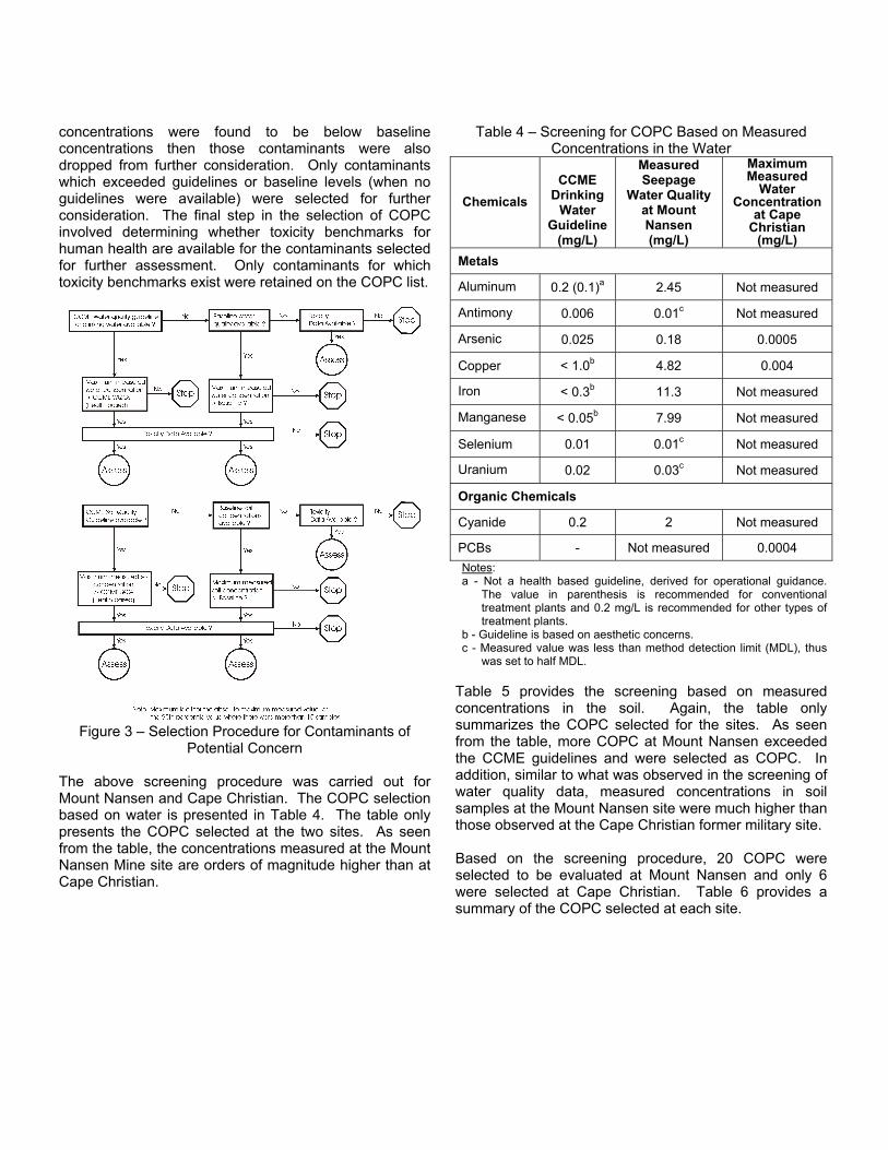
concentrations were found to be below baseline concentrations then those contaminants were also dropped from further consideration. Only contaminants which exceeded guidelines or baseline levels (when no guidelines were available) were selected for further consideration. The final step in the selection of COPC involved determining whether toxicity benchmarks for human health are available for the contaminants selected for further assessment. Only contaminants for which toxicity benchmarks exist were retained on the COPC list.
Figure 3 – Selection Procedure for Contaminants of
Potential Concern The above screening procedure was carried out for Mount Nansen and Cape Christian. The COPC selection based on water is presented in Table 4. The table only presents the COPC selected at the two sites. As seen from the table, the concentrations measured at the Mount Nansen Mine site are orders of magnitude higher than at Cape Christian.
Table 4 – Screening for COPC Based on Measured Concentrations in the Water
Chemicals CCME
Drinking Water
Guideline (mg/L)
Measured Seepage
Water Quality at Mount Nansen (mg/L)
Maximum Measured
Water Concentration
at Cape Christian
(mg/L) Metals
Aluminum 0.2 (0.1)a 2.45 Not measured
Antimony 0.006 0.01c Not measured
Arsenic 0.025 0.18 0.0005
Copper < 1.0b 4.82 0.004
Iron < 0.3b 11.3 Not measured
Manganese < 0.05b 7.99 Not measured
Selenium 0.01 0.01c Not measured
Uranium 0.02 0.03c Not measured
Organic Chemicals
Cyanide 0.2 2 Not measured
PCBs - Not measured 0.0004 Notes: a - Not a health based guideline, derived for operational guidance.
The value in parenthesis is recommended for conventional treatment plants and 0.2 mg/L is recommended for other types of treatment plants.
b - Guideline is based on aesthetic concerns. c - Measured value was less than method detection limit (MDL), thus
was set to half MDL. Table 5 provides the screening based on measured concentrations in the soil. Again, the table only summarizes the COPC selected for the sites. As seen from the table, more COPC at Mount Nansen exceeded the CCME guidelines and were selected as COPC. In addition, similar to what was observed in the screening of water quality data, measured concentrations in soil samples at the Mount Nansen site were much higher than those observed at the Cape Christian former military site. Based on the screening procedure, 20 COPC were selected to be evaluated at Mount Nansen and only 6 were selected at Cape Christian. Table 6 provides a summary of the COPC selected at each site.

Table 5 – Screening for COPC Based on Measured Concentrations in the Soil
Chemical
CCME Soil
Quality Guideline (Human Health)a (mg/kg)
Maximum Measured Soil Concentration
at Mount Nansen (mg/kg)
Maximum Measured Soil Concentration
at Cape Christian (mg/kg)
Metals Antimony 20 * 310 31 Arsenic 12 1,240 1.6 Barium 500 * 530 161 Boron 4 * Not measured 5 Lead 140 760 152.8
Molybdenum 10 * 13,700 23.8 Zinc 200 * 1790 292.9
Organic Chemicals TPH (C6-C10) –
50b
1,500c 61 Not measured
TPH (C10-19) – Fraction 2
240b 8,000c
54,100 Not measured
TPH (C19-32) – Fraction 3
18,000c 50,700 Not measured
Notes: a - From CCME (2002), human health component of the soil quality
guideline for residential/parkland, except as noted (*) where the soil quality guideline is used in the absence of a human health component.
b - Canada-Wide Standard for Petroleum Hydrocarbons in Soil – Vapour Inhalation (Indoor, slab-on-grade) from CCME 2000 residential land use.
c - Canada-Wide Standard for Petroleum Hydrocarbons in Soil – Soil Ingestion from CCME 2000 residential land use.
Table 6 – COPC Selected at Each Site
COPC Selected for Mount Nansen
COPC Selected for Cape Christian
Aluminum Antimony Antimony Boron Arsenic Lead Barium Molybdenum Cobalt PCBs Copper Zinc Cyanide
Lead Manganese Molybdenum
Nickel Selenium
Silver Strontium
Thiocyanate Uranium
Zinc F1-TPH (C6-C10) F2-TPH (C10-C16) F3-TPH (C16-C34)
Besides data being available for water and soils at the two sites, sediment data were available for both sites. In addition, vegetation data were available for the Cape Christian site. COPC concentrations in other media were calculated using transfer factors reported in the literature. Receptor Characterization An adult and child (5 to 11 years) were assumed to camp on the Mount Nansen site. These individuals were assumed to spend three months of the year on the site and obtain wild game, berries, and drinking water from the mine site area and to come in contact with and ingest contaminated soil. Fish were not considered as the water bodies which run through the site were too small to support a fisheries habitat and the main water body downstream of the site had no fish at all. Cape Christian is located 16 km from the Hamlet of Clyde River, therefore, two hypothetical human receptors (Inuit) were considered for the assessment of potential exposures. An adult and child were assumed to visit the site annually and to camp on the site for a maximum of 2 months of the year. While on-site, the receptors were assumed to obtain all drinking water from the freshwater reservoir on-site, to consume some food (hare and grouse), and to inadvertently come in contact with and ingest contaminated soil. Water intake, breathing rate, soil ingestion rate, body weight and other exposure properties for the human receptors were obtained from the “Compendium of Canadian Human Exposure Factors for Risk Assessment” (Richardson 1997). In lieu of diet and intake estimates for communities in the region of Mount Nansen, the dietary characteristics of the adult and child were based on a survey for the Dene living in the Sahtu settlement area in the NWT (Receveur et al. 1996). For Cape Christian, the dietary characteristics of a Inuit living in the NWT (Receveur et al. 1996) were assumed to be representative of the Inuit living on Baffin Island. Toxicity Assessment Toxicity benchmarks from Health Canada (Health Canada 2003) were selected first; however, if more restrictive benchmarks were available from another regulatory agency such as the U.S. EPA, those values were selected instead of the Health Canada values to ensure that the risks calculated in the assessment were over-estimated. Additionally, if a contaminant had properties of both a carcinogen and a non-carcinogen by

a specific pathway (i.e. arsenic), then only the carcinogenic effects were assessed. Exposure Assessment Exposure estimates for the adult and child receptors were calculated using the equations provided in the Screening Level document provided by Health Canada (Health Canada 2003). A spreadsheet program was developed for the exposure assessment to ensure that the calculations for all 24 sites (including the Mount Nansen and Cape Christian sites) were all carried out in the same manner. Characterization of Chemical Risks Risk characterization involves the integration of the information from the exposure assessment and the toxicity assessment. For convenience, non-carcinogenic chemical effects are often expressed as a hazard quotient, which is calculated as the ratio of the exposure estimate to the toxicity reference value. Where multiple chemicals are involved, an overall hazard quotient was calculated as the sum of the quotients estimated for the individual chemicals. This is not entirely correct as the chemicals have different endpoints of harm (i.e. stomach, liver, kidney, etc.) but is appropriate to use in a scheme for ranking sites. Hazard quotient values greater than a pre-selected value are considered to indicate an unacceptable level of risk of potential adverse effect. The criterion used to select an acceptable hazard quotient is based on the number of pathways taken into account in the exposure assessment. In the SLRAs for mine and former military sites, the following hazard quotient values were used:
• In applications where only a few pathways were considered in the assessment, a HQ value of 0.2 was used to identify acceptable exposure.
• Where multiple pathways were considered, such as inhalation, ingestion of water, soil and food from the site and dermal exposure, then a HQ value of 0.5 was used to assess acceptable exposures, given that the major dietary components were being included.
For the Mount Nansen site, a HQ value of 0.5 was used to assess acceptable exposures. For the Cape Christian site, a HQ value of 0.2 was used to assess acceptable exposures. For Mount Nansen, the hazard quotients calculated for antimony (ingestion and dermal pathways), copper,
cyanide, molybdenum, thiocyanate (ingestion pathways), uranium (ingestion and dermal pathways), zinc, petroleum hydrocarbons F1 and F2 (Aliphatic and Aromatic), and F3 Aromatic (child only) exceeded the critical value of 0.5. The sum of all HQs was determined to be 27.4 for the adult and 41.2 for the child.
For Cape Christian, none of the contaminants exceeded the hazard quotient of 0.2 for either the adult and child receptors. The sum of all HQs was determined to be 0.11 for the adult and 0.21 for the child.
Characterization of Physical Risks Physical risks at the Mount Nansen Mine site were identified to be associated with unsealed mine openings, high pit walls, steep loose rock piles and unstable surface structures. Accordingly, the hazard factor was assessed to equal 1 (i.e. 40/40). Based on the ease of road access to the area and the small population that lives close to the site, the accessibility factor was set equal to 1. Finally, the scaling factor was also set equal to 1 based on the amount of waste stored on-site. Using these factors and an average annual fatality rate of 2.9 x 10⁻⁶, the annual fatality rate from the Mount Nansen Mine site was estimated to equal 2.9 x 10⁻⁶. As previously stated, physical risks were not estimated for the former military sites. SUMMARY As part of the process for prioritizing reclamation funding for abandoned mines and former military sites in northern Canada, Indian and Northern Affairs Canada required that a methodology be developed to rank the relative risks of such sites. Furthermore, timing constraints dictated that this harmonized approach be used to assess the risks associated with 11 abandoned mine sites and 13 former military sites within an eight week period. A standardized methodology was developed for the SLHHRA, to ensure that a consistent approach was applied by the team (ten individuals) assigned to the project. The approach has been summarized in this paper and example applications were presented for one of the mine sites and one of the former military site. This standardized methodology made it possible to complete the assessments within the time constraint. At the end of the process, the human health risks and physical risks were summarized in a tabular fashion to determine whether the results of all the assessments were in keeping with the contamination found at the sites.

Not unexpectedly, it was found that the mine sites ranked higher than the former military sites as was demonstrated by the examples discussed in this paper. This finding is consistent with the wide range of contamination found at the mine sites and the large differences in the scale of the areas affected by the activities. Of the eleven mines evaluated in the assessment, the Giant Mine located near Yellowknife in the Northwest Territories and the Anvil Range Mine located near Faro in the Yukon were the highest ranking mine sites due to several potential chemical and physical risks at each site and the potential to impact negatively on nearby communities if no remediation is undertaken. With respect to the thirteen former military sites, it was found that sites where several chemicals were measured at elevated levels in soil samples tended to rank higher than the military sites that did not have substantial soil contamination. To conclude, the methodology developed for assessing human health risks at the abandoned mine sites and former military sites proved to be an effective means of the assessing the relative risks of the sites. The SLRAs results comprised an important component of the considerations taken into account in the final rating of the sites and submission to Treasury Board. ACKNOWLEDGEMENTS This project was funded by the Department of Indian and Northern Affairs Canada.
REFERENCES
Canadian Council of Ministers of the Environment (CCME) 1999. Canadian Environmental Quality Guidelines. Pub No. 1299.
Health Canada. 2003. Guidance on Human Health Screening Level Risk Assessment. Federal Contaminated Site Risk Assessment in Canada. Version 1.1. Environmental Health Assessment Services. Safe Environments Program. Ottawa, Ontario. October 3.
Health Canada 2003. Health Canada Toxicological Reference Values
Receveur, O., M. Boulay, C. Mills, W. Carpenter and H.V. Kuhnlein 1996. Variance in Food Use in Dene/Métis Communities. Centre for Indigenous People’s Nutrition and Environment.
Richardson, G.M. 1997. Compendium of Canadian Human Exposure Factors for Risk Assessment. O’Connor Associates.
PRESENTATION This paper was presented at the Assessment and Remediation of Contaminated Sites in Arctic and Cold Climates (ARCSACC) conference held on May 8 to 10, 2005 in Edmonton, Alberta.