Embed Size (px)
Citation preview
Abstract—With the development and awareness of social
affairs concerning locating missing person and location
detection services has been widely on demand. This paper
explains the design and experiment of incorporating the GPS &
GSM network positioning technology to deliver a location-
based service for tracking and detecting human. In this study,
GPS and GSM feature were utilized to emulate the tracking
and detection process. Integration of this technology is
supported by the use of several applications, devices and
services. The proposed model comprises of GPS sender and
receiver, GSM service and provider. With the extensive use of
smartphones and mobile applications, this model is useful to
identify the location of a person in a public area and may
benefit parents in monitoring and tracking their children
whereabouts. This paper, presented the methods adopted in
developing of the initial prototype as a pilot study. The result of
the evaluation discussed recommendations for further
improvement in the prototype development. This shall be
achieved by adding specific values for a better outcome. A detail
result on the improvement will be discussed in the next paper.
The purpose of this study is to share this information with other
researcher and to foresee ways to improve the current processes
hence the same study can be initiated and explored by others. A
further enhancement of this service shall be proposed and
another set of evaluation should be performed thus there be a
potential for application commercialization.
Index Terms—Global positioning system (GPS), global
system for mobile (GSM), human tracking and detection.
I. INTRODUCTION
Many cases of missing person in a public area were
reported and fast detection is highly demanded. This
situation may be commonly seen in the after effect of natural
disasters, earth quake, tsunami and others. Other scenario
where people is always on the move, for instance annual Hajj
seasons where there are too many people move in groups
from one location to another may leads to tendency of
missing a group members including spouse, siblings or
friends. Thus getting hold of one person may be difficult to
be performed without the aid of automated process or tools.
While missing person case is another popular daily
newspaper storyline. This situation occurs all over the globe.
Hence with the Social responsibility and awareness of the
community concerning this issue, a study on developing the
service model via GPS and GSM technology were conducted.
The huge population of smartphones users all over the world
is the reason being why these services is adopted in this
Manuscript received May 18, 2015; revised September 16, 2016.
The authors are with the Software Information Systems Section at
Universiti Kuala Lumpur, Malaysian Institute of Information Technology,
Malaysia (e-mail: [email protected], [email protected]).
study. Generally in this study will involve the use of
smartphones and the telecommunication services. With the
Global Positioning System (GPS) as a medium using the
satellite-based navigation system, it will provide the latitude
& longitude of the device. This system comprise of a
database of every registered routes and location recorded on
the map. The Global System for Mobile (GSM) technology
is adopted to transmit voice and text to complement the
proposed prototype, this is to for the purpose of supporting
emergency cases. GSM service is widely used as
communication medium where sending and receiving
process occur via a device from remote locations [1], [2].
II. WHAT IS HUMAN TRACKING AND DETECTION
The Human Tracking and Detection service comprise of
combination of a devices and application to perform the
tracking and detecting process. Two devices are required to
achieve this. Device A will is use to send signals, this is
known as the tracking device. While device B is used as
receiver consists of an android smartphone. The detail
requirement of each of the devices is as follows:
i. Human Tracking and Detection device (Device A)
a. Sending the coordinate
b. Sending panic alert with Real-time voice message
ii. Smartphone user (Device B)
a. View coordinates via Location Identification
Application
b. Receiver can receive coordinate
c. Receiver can receive Real-time voice message
d. Receiver can send message request to the Sender
device
A. Why Human Tracking and Detection
Identifying and locating a person in an infinite public area
is not easy. What more if it is done manually. This may be
the after effect situation where the occurrence of natural
disaster such as earthquake, huge flood and others.
According to reports in Malaysian tabloids, on average there
are four (4) missing person daily reported. Many of the
missing persons identified were aged below eighteen (18)
years old [3].
Almost every day, cases of missing person were reported.
A gadget to prevent this is needed thus a person’s location
can be tracked and detected. In emergency cases where
phone call is impossible, a device may save life. Many have
been looking for solution as a service to inhibit situation.
With this issue to solve, with the widely use existing GPS &
GSM technology, a pilot study is conducted to experiment
Development of Location Detection and Human Tracking
Application via GPS and GSM Service: A Pilot Study
Inurina Ibrahim and Engku Mohammad Nazreen B. Engku Azman
Journal of Advances in Computer Networks, Vol. 4, No. 3, September 2016
doi: 10.18178/jacn.2016.4.3.227 179
the development of a human tracking and detection
application prototype.
III. RELATED WORK
Many GPS and GSM technology models have been
developed to trace mobility of an object such as vehicle,
person or anything physically detectable. Several related
studies is as highlighted [1].
A cost effective method of object tracking using GPS and
GPRS technology was proposed by Khondker Shajadul
Hasan, Mashiur Rahman, Abdul L. Haque, M. Abdur
Rahman, Tanzil Rahman and M. Mahbubur Rashed in 2009.
This method allows user to view the location of the object as
well as the past history of its movement using Google Map
and Internet [4].
In 2011, Ruchika Gupta in “GPS and GPRS Based Cost
Effective Human Tracking System Using Mobile Phones”
proposed a mobile phone application developed and
deployed on an Android Phone to track the GPS location and
send it to a remote location by creating a GPRS packet. This
is an approach that the whole system allows the user's
mobility to be tracked using a mobile phone which is
equipped with an internal GPS receiver and GPRS
transmitter [5].
A. (GSM)
Global Positioning System (GSM).The use of GSM
gained its popularity by more than 200 countries in the world
since early 2000 and by 2005 this technology has been
subscribed by more than 1.5 people which represents 78% of
the world market [6]. Based on the result of the study, Sohn
et al. on Mobility detection using GSM traces, proved that
GSM sensor is best used to detect high level activity on
mobile phones in any location. Hence this sensor is adopted
in this study to suit the purpose.
Fig. 1 below shows the result of GSM sensor based on
study performed by Sohn et al. regarding precision and
predicted movement. The overall result shows 85% accuracy
of the tests.
Fig. 1. Result of GSM sensor based on study performed by Sohn et al.
Sameer Darekar, Atul Chikane, Rutujit Diwate, Amol
Deshmukh, and Prof. Archana Shinde in 2012, have
developed a Multi-Tracking system to trace objects using
GPS and GSM technology. They have recommended many
other areas of study to be conducted such as tracking
movable assets, antitheft vehicle and managing
transportation may be applied in the future [7].
In 2013, Anjor Jadhav, Savita Kharje, Pooja More and
Prof. Nasim Shah proposed a mobile tracking application
based on GPS using the geographical co-ordinates of the
user to locate the mobile device. It claims able to effectively
calculate the distance between the user and the located
friends based on the ones who are closest to the user. The
GSM service is used by sending SMS to the selected mobile
number to notify message and location of the person [8].
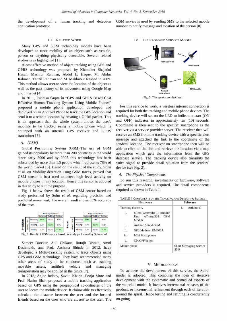
IV. THE PROPOSED SERVICE MODEL
Fig. 2. The system architecture.
For this service to work, a wireless internet connection is
required for both the tracking and mobile phone devices. The
tracking device will set on the LED to indicate a start (ON
and OFF) indicator in approximately ten (10) seconds.
Coordinate is then sent to the specific smartphone as the
receiver via a service provider server. The receiver then will
receive an SMS from the tracking device with a specific alert
message and attached the link to the coordinate of the
senders’ location. The receiver on smartphone then will be
able to click on the link and retrieve the location via a map
application which gets the information from the GPS
database service. The tracking device also transmits the
voice signal to provide detail situation from the senders’
device (see Fig. 2).
A. The Physical Components
To run this research, investments on hardware, software
and service providers is required. The detail components
required as shown in Table I.
TABLE I: COMPONENTS OF THE TRACKING AND DETECTING SERVICE
Hardware Software
Tracking device A
i. Micro Controller : Arduino
Uno ATmega328 GSM
Module
ii. Arduino Shield GSM
iii. GPS Module : EM406A
iv. Mini Microphone
v. ON/OFF button
i. Arduino C
Mobile phone Short Messaging Service
SMS
V. METHODOLOGY
To achieve the development of this service, the Spiral
model is adopted. This combines the idea of iterative
development with the systematic and controlled aspects of
the waterfall model. It involves incremental releases of the
product, or incremental refinement through each of iteration
around the spiral. Hence testing and refining is concurrently
on-going.
Journal of Advances in Computer Networks, Vol. 4, No. 3, September 2016
180
The process includes, initial study, design, development
and evaluation which is performed iteratively along the pilot
study. This method has been applied by many researcher and
system developer with proven success.
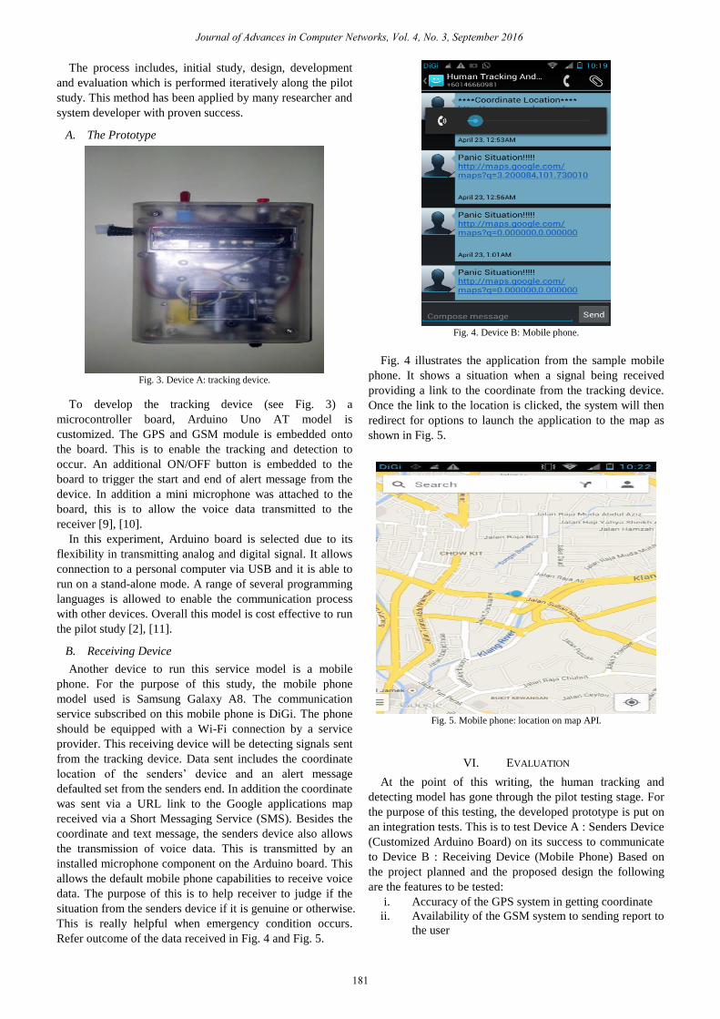
A. The Prototype
Fig. 3. Device A: tracking device.
To develop the tracking device (see Fig. 3) a
microcontroller board, Arduino Uno AT model is
customized. The GPS and GSM module is embedded onto
the board. This is to enable the tracking and detection to
occur. An additional ON/OFF button is embedded to the
board to trigger the start and end of alert message from the
device. In addition a mini microphone was attached to the
board, this is to allow the voice data transmitted to the
receiver [9], [10].
In this experiment, Arduino board is selected due to its
flexibility in transmitting analog and digital signal. It allows
connection to a personal computer via USB and it is able to
run on a stand-alone mode. A range of several programming
languages is allowed to enable the communication process
with other devices. Overall this model is cost effective to run
the pilot study [2], [11].
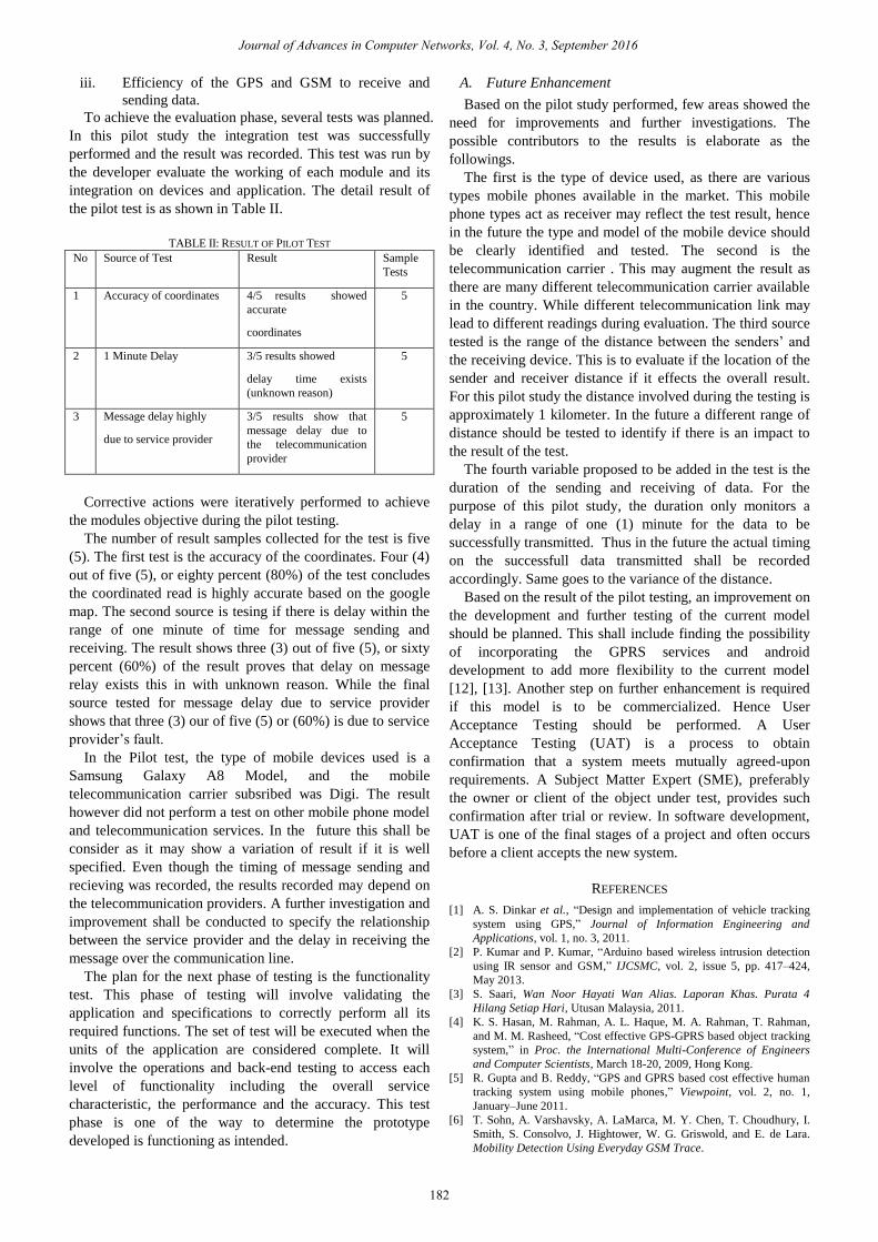
B. Receiving Device
Another device to run this service model is a mobile
phone. For the purpose of this study, the mobile phone
model used is Samsung Galaxy A8. The communication
service subscribed on this mobile phone is DiGi. The phone
should be equipped with a Wi-Fi connection by a service
provider. This receiving device will be detecting signals sent
from the tracking device. Data sent includes the coordinate
location of the senders’ device and an alert message
defaulted set from the senders end. In addition the coordinate
was sent via a URL link to the Google applications map
received via a Short Messaging Service (SMS). Besides the
coordinate and text message, the senders device also allows
the transmission of voice data. This is transmitted by an
installed microphone component on the Arduino board. This
allows the default mobile phone capabilities to receive voice
data. The purpose of this is to help receiver to judge if the
situation from the senders device if it is genuine or otherwise.
This is really helpful when emergency condition occurs.
Refer outcome of the data received in Fig. 4 and Fig. 5.
Fig. 4. Device B: Mobile phone.
Fig. 4 illustrates the application from the sample mobile
phone. It shows a situation when a signal being received
providing a link to the coordinate from the tracking device.
Once the link to the location is clicked, the system will then
redirect for options to launch the application to the map as
shown in Fig. 5.
Fig. 5. Mobile phone: location on map API.
VI. EVALUATION
At the point of this writing, the human tracking and
detecting model has gone through the pilot testing stage. For
the purpose of this testing, the developed prototype is put on
an integration tests. This is to test Device A : Senders Device
(Customized Arduino Board) on its success to communicate
to Device B : Receiving Device (Mobile Phone) Based on
the project planned and the proposed design the following
are the features to be tested:
i. Accuracy of the GPS system in getting coordinate
ii. Availability of the GSM system to sending report to
the user
Journal of Advances in Computer Networks, Vol. 4, No. 3, September 2016
181
iii. Efficiency of the GPS and GSM to receive and
sending data.
To achieve the evaluation phase, several tests was planned.
In this pilot study the integration test was successfully
performed and the result was recorded. This test was run by
the developer evaluate the working of each module and its
integration on devices and application. The detail result of
the pilot test is as shown in Table II.
TABLE II: RESULT OF PILOT TEST
No Source of Test Result Sample
Tests
1 Accuracy of coordinates 4/5 results showed
accurate
coordinates
5
2 1 Minute Delay 3/5 results showed
delay time exists
(unknown reason)
5
3 Message delay highly
due to service provider
3/5 results show that
message delay due to
the telecommunication
provider
5
Corrective actions were iteratively performed to achieve
the modules objective during the pilot testing.
The number of result samples collected for the test is five
(5). The first test is the accuracy of the coordinates. Four (4)
out of five (5), or eighty percent (80%) of the test concludes
the coordinated read is highly accurate based on the google
map. The second source is tesing if there is delay within the
range of one minute of time for message sending and
receiving. The result shows three (3) out of five (5), or sixty
percent (60%) of the result proves that delay on message
relay exists this in with unknown reason. While the final
source tested for message delay due to service provider
shows that three (3) our of five (5) or (60%) is due to service
provider’s fault.
In the Pilot test, the type of mobile devices used is a
Samsung Galaxy A8 Model, and the mobile
telecommunication carrier subsribed was Digi. The result
however did not perform a test on other mobile phone model
and telecommunication services. In the future this shall be
consider as it may show a variation of result if it is well
specified. Even though the timing of message sending and
recieving was recorded, the results recorded may depend on
the telecommunication providers. A further investigation and
improvement shall be conducted to specify the relationship
between the service provider and the delay in receiving the
message over the communication line.
The plan for the next phase of testing is the functionality
test. This phase of testing will involve validating the
application and specifications to correctly perform all its
required functions. The set of test will be executed when the
units of the application are considered complete. It will
involve the operations and back-end testing to access each
level of functionality including the overall service
characteristic, the performance and the accuracy. This test
phase is one of the way to determine the prototype
developed is functioning as intended.
A. Future Enhancement
Based on the pilot study performed, few areas showed the
need for improvements and further investigations. The
possible contributors to the results is elaborate as the
followings.
The first is the type of device used, as there are various
types mobile phones available in the market. This mobile
phone types act as receiver may reflect the test result, hence
in the future the type and model of the mobile device should
be clearly identified and tested. The second is the
telecommunication carrier . This may augment the result as
there are many different telecommunication carrier available
in the country. While different telecommunication link may
lead to different readings during evaluation. The third source
tested is the range of the distance between the senders’ and
the receiving device. This is to evaluate if the location of the
sender and receiver distance if it effects the overall result.
For this pilot study the distance involved during the testing is
approximately 1 kilometer. In the future a different range of
distance should be tested to identify if there is an impact to
the result of the test.
The fourth variable proposed to be added in the test is the
duration of the sending and receiving of data. For the
purpose of this pilot study, the duration only monitors a
delay in a range of one (1) minute for the data to be
successfully transmitted. Thus in the future the actual timing
on the successfull data transmitted shall be recorded
accordingly. Same goes to the variance of the distance.
Based on the result of the pilot testing, an improvement on
the development and further testing of the current model
should be planned. This shall include finding the possibility
of incorporating the GPRS services and android
development to add more flexibility to the current model
[12], [13]. Another step on further enhancement is required
if this model is to be commercialized. Hence User
Acceptance Testing should be performed. A User
Acceptance Testing (UAT) is a process to obtain
confirmation that a system meets mutually agreed-upon
requirements. A Subject Matter Expert (SME), preferably
the owner or client of the object under test, provides such
confirmation after trial or review. In software development,
UAT is one of the final stages of a project and often occurs
before a client accepts the new system.
REFERENCES
[1] A. S. Dinkar et al., “Design and implementation of vehicle tracking
system using GPS,” Journal of Information Engineering and
Applications, vol. 1, no. 3, 2011.
[2] P. Kumar and P. Kumar, “Arduino based wireless intrusion detection
using IR sensor and GSM,” IJCSMC, vol. 2, issue 5, pp. 417–424,
May 2013.
[3] S. Saari, Wan Noor Hayati Wan Alias. Laporan Khas. Purata 4
Hilang Setiap Hari, Utusan Malaysia, 2011.
[4] K. S. Hasan, M. Rahman, A. L. Haque, M. A. Rahman, T. Rahman,
and M. M. Rasheed, “Cost effective GPS-GPRS based object tracking
system,” in Proc. the International Multi-Conference of Engineers
and Computer Scientists, March 18-20, 2009, Hong Kong.
[5] R. Gupta and B. Reddy, “GPS and GPRS based cost effective human
tracking system using mobile phones,” Viewpoint, vol. 2, no. 1,
January–June 2011.
[6] T. Sohn, A. Varshavsky, A. LaMarca, M. Y. Chen, T. Choudhury, I.
Smith, S. Consolvo, J. Hightower, W. G. Griswold, and E. de Lara.
Mobility Detection Using Everyday GSM Trace.
Journal of Advances in Computer Networks, Vol. 4, No. 3, September 2016
182
[7] S. Darekar, A. Chikane, R. Diwate, A. Deshmukh, A. Shinde,
“Tracking system using GPS and GSM: Practical approach,”
International Journal of Scientific & Engineering Research, vol. 3,
issue 5, May-2012.
[8] A. Jadhav, S. Kharje, P. More, and N. Shah, “Track your buddies,” in
Proc. National Conference on New Horizons in IT, 2013.
[9] P. Teikaria, R. P. Najjara, and H. Malkkic, “An inexpensive Arduino-
based LED stimulator system for vision research,” Elsevier Journal of
Neuroscience Methods, vol. 211, issue 2, pp. 227–236, November 15,
2012.
[10] M. Bohmer, Beginning Android ADK with Adruino, APress.
[11] A. Garg, A. K. Shudhanshu, R. Kumar, S. R. Bharadwaj, R. Tehri, and
C. K. Samal, “Development of open source low cost wireless data
acquisition systems for science experiments,” International Journal of
Information & Computation Technology, vol. 4, no. 12, pp. 1123-
1128, 2014.
[12] S. Lee, G. Tewolde, and J. Kwon, “Design and Implementation of
Vehicle Tracking System Using GPS/GSM/GPRS Technology and
Smartphone Application,” in Proc. 2014 IEEE World Forum on
Internet of Things (WF-IoT), IEEE.
[13] K. Maurya, M. Singh, and N. Jain, “Real time vehicle tracking system
using GSM and GPS technology — An anti-theft tracking system,”
International Journal of Electronics and Computer Science
Engineering.
Inurina Ibrahim was born in Kuala Lumpur Malaysia
on 19 May 1974. Graduated in Bachelor of Science in
Business Administration Majoring in Management
Science and Information Systems from University of
Rhode Island, USA in 1997. Completed her MSc
(Hons) in Information Technology from Universiti
Utara Malaysia in 2007.
She has been in the academic field for 18 years
since the 1998. Before joining as academic members,
she had experience working with the service industry as the Web Master
and IT Executive. During her employment with University Kuala Lumpur,
she gained good numbers of experienced in the area of System
Development & Design as well as Project Management. Experienced to
work on SUTRA Project as a Consultant and Team Leader in a SUTRA
Project in 2012 to 2013.
Inurina Ibrahim is a Certified EC-Council E Commerce Professional in
Project Management. She have published numbers of research papers
including one on Teaching Project Management Methods and Approach for
IT Students.
Journal of Advances in Computer Networks, Vol. 4, No. 3, September 2016
183