Embed Size (px)
Citation preview
The Indian Journal of Spatial Science
Vol. II No. 2 — 2011
Article 1
Development of Spatial Database for Sustainable Micro-level Planning of
Chandanpur Mouza, Purulia, West Bengal
Abhijit Ghosh Proshanta Kumar Ghosh
Debajit Datta
ISSN: 2249-4316
The Indian Journal of Spatial Science
ISSN: 2249-4316
Vol. II No. 2 — 2011
Article 1Development of Spatial Database for Sustainable Micro-level Planning of Chandanpur Mouza, Purulia, West Bengal
Abhijit Ghosh Proshanta Kumar Ghosh
Debajit Datta
Paper received on 04.03.2011 Paper accepted in revised form on 11.11.2011
© The Geographical Institute, 2011
Published by Prof Ashis Sarkar
on behalf ofThe Geographical InstituteDepartment of Geography
Presidency University (formerly College)86/1 College Street, Kolkata 700073, India
[email protected]. +91 33 2241 1960 Ext. 206
Typeset and layout by Computer Club
Vol. II, No. 2, Article 1— 1
Development of Spatial Database for Sustainable Micro-level Planning of Chandanpur Mouza, Purulia, West Bengal
Abhijit Ghosh Proshanta Kumar Ghosh
Debajit Datta
Micro-level planning in a comprehensive way, acts as one of the key factors in sustainable rural development and natural resource management. For preparation of appropriate micro-level planning strategies, proper and sufficient amount of real time spatial database is needed which can be successfully developed through digital mapping and decision support systems like GIS. Chandanpur Mouza in the Bhagabandh GP, Barabazar Block of Purulia District, West Bengal has been studied on a pilot basis for the preparation of such spatial databases with the ultimate objective of sustainable development and management of the area.
The virtual disparity in terms of social, economic, political and most importantly infrastructural status has been growing between rural and urban India throughout the last three decades. Rural areas across the country are paralyzed with a wide spectrum of severe problems like lack of access to drinking water and other civic amenities, outdated techniques of traditional agrarian systems, increasing rate of soil and natural resource degradation, poor communication status, low level of per capita income, gender inequality, less participation in community decision making and so on (GOI, 1981). This list is exclusive and growing on day by day.
Hence, sustainable rural development is the need of the hour; decision makers and academicians across a number of disciplines have engaged themselves to find out the possible solutions for these menaces (Agarwal, 1996). A significant amount of literature and research initiatives can be traced which have advocated for comprehensive micro-level planning and development efforts within a community based management scenario (Poudevigne and Alard, 1997; Schmidt-Kallert, 2005). In this study, a remote mouza named Chandanpur located in the rural heartland of West Bengal has been chosen for the development of spatial databases needed for sustainable micro-level planning. These types of databases, when prepared for all the mouzas of a particular block in
a digital Geographical Information System (GIS) environment, do essentially provide the basis for future land use planning and community decision making (Dutta and Singh, 2007).
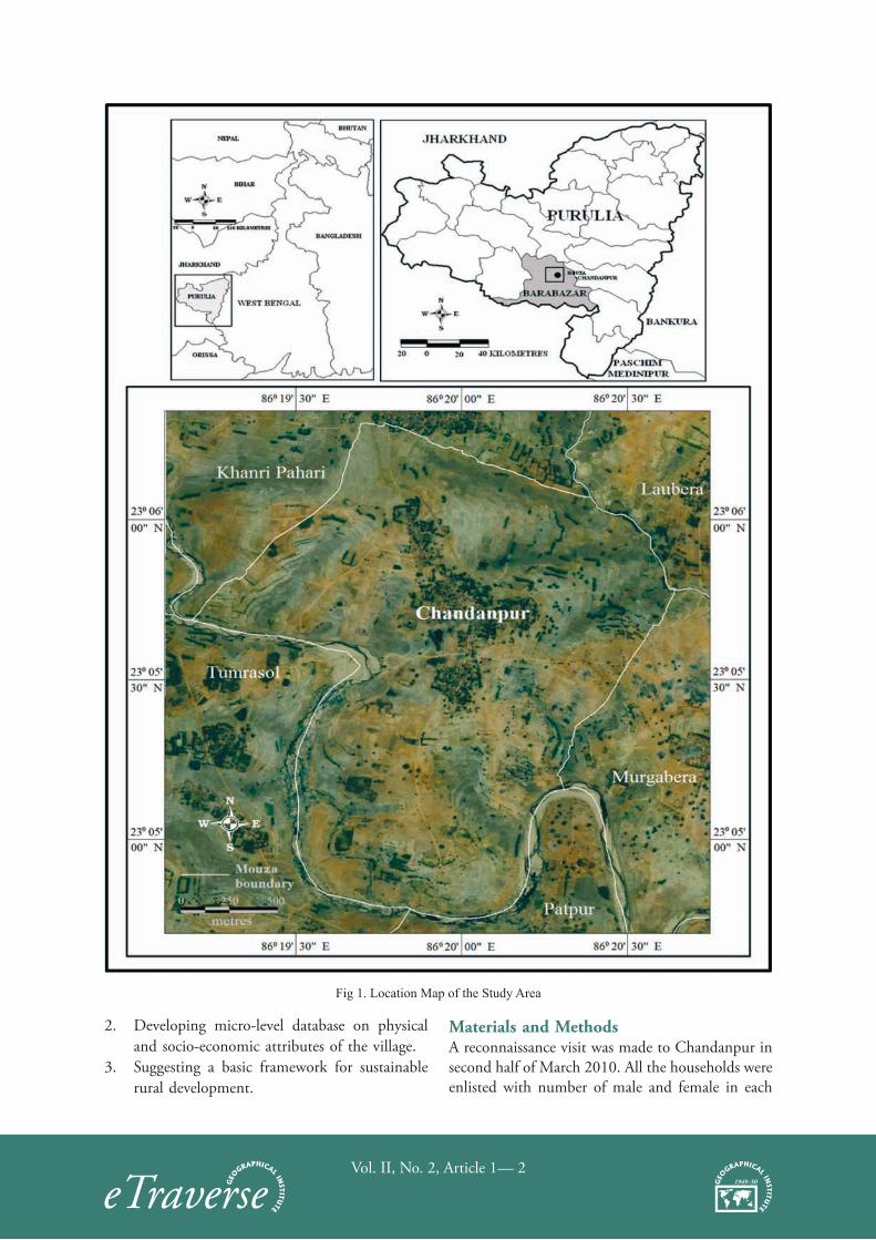
Study AreaChandanpur is a revenue mouza in the Bhagabandh gram panchayat (GP) within Barabazar block of Purulia district. It is located on the left bank of the River Kumari, the mouza-area extends from 23° 04' 45" N to 23° 06' 18" N and 86° 19' 11" E to 86° 20' 39" E. It is administratively surrounded by Khanri Pahari mouza in the north, Tumrasol in the west and Patpur in the south and Laubera and Murgabera in the east (Fig 1.). The total area of the mouza is 401.2 ha (991.44 acre) and its J.L. No. is 90. With 227 households, it contains a total of 1250 population (field level enumeration, March 2010). Although the study area is not so large it is possible to find some diversity in the distribution of the physical as well as socio-cultural attributes of the area. Geomorphologically, it is a part of dissected erosional plain, dominantly developed by fluvial and other geomorphic agents of erosion.
ObjectivesMajor objectives of the present study are:1. Generating village level data amalgamating low
cost remote sensing products with conventional maps and indigenous knowledge.
Vol. II, No. 2, Article 1— 2
Fig 1. Location Map of the Study Area
2. Developing micro-level database on physical and socio-economic attributes of the village.
3. Suggesting a basic framework for sustainable rural development.
Materials and MethodsA reconnaissance visit was made to Chandanpur in second half of March 2010. All the households were enlisted with number of male and female in each
Vol. II, No. 2, Article 1— 3
of them. This list of households was used to select the sample households in a later stage of the study. The cadastral map of Chandanpur mouza (Revenue Survey map 1972-78) was scanned and georeferenced using Mapinfo 7.0. The mouza boundary was digitized from this map. Satellite image (dated May 17, 2005) of the area was downloaded from Google Earth and georeferenced. The vectorized mouza boundary was then superimposed on the Google Earth image. Different land use / land cover types were visually identified and digitized. Different land classes (based on traditional classification) were also demarcated. Draft maps showing details of land use / land cover and land classes were prepared. With these draft maps a second visit was made to the village in first half of November 2010. A plot level field survey was carried out with the cadastral map to: a) verify the draft maps of land use and land
class;b) collect data on agriculture, irrigation, water
bodies etc.At each step of survey, villagers were consulted
regularly and local/traditional knowledge on physical and cultural environments were given higher preference. In most cases villagers were given a role to scrutinize the draft maps. Thus quality and reliability of maps were enhanced to a greater extent. A door to door sample survey was carried out using random sampling method to collect primary data on socio-economic condition of the village.
All these data and maps were then analyzed and a broad development framework for the studied mouza was worked out.
Development of Database on Physical EnvironmentFor proper development of any geographical area, it is necessary to construct a concrete database on the physical set-up of the area in question for any kind of infrastructural up-gradation. Hence, information about the physiography and soil characteristics have been collected and processed for spatial representation.
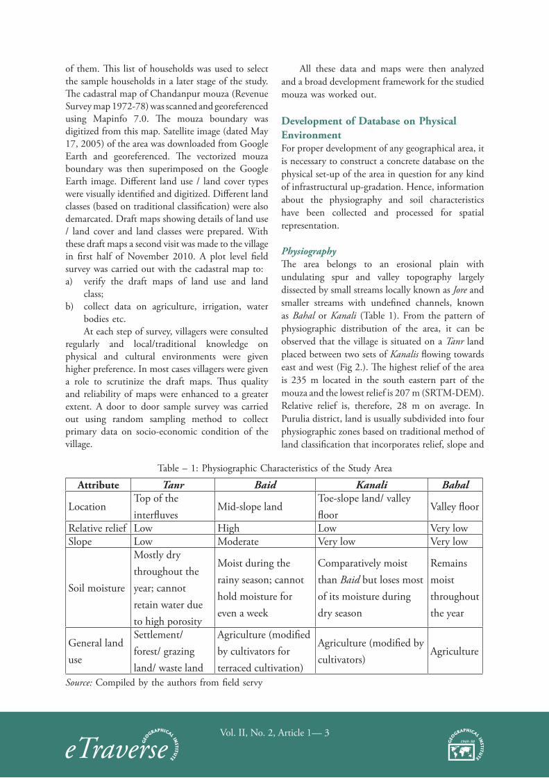
PhysiographyThe area belongs to an erosional plain with undulating spur and valley topography largely dissected by small streams locally known as Jore and smaller streams with undefined channels, known as Bahal or Kanali (Table 1). From the pattern of physiographic distribution of the area, it can be observed that the village is situated on a Tanr land placed between two sets of Kanalis flowing towards east and west (Fig 2.). The highest relief of the area is 235 m located in the south eastern part of the mouza and the lowest relief is 207 m (SRTM-DEM). Relative relief is, therefore, 28 m on average. In Purulia district, land is usually subdivided into four physiographic zones based on traditional method of land classification that incorporates relief, slope and
Table – 1: Physiographic Characteristics of the Study Area
Attribute Tanr Baid Kanali Bahal
LocationTop of the interfluves
Mid-slope landToe-slope land/ valley floor
Valley floor
Relative relief Low High Low Very lowSlope Low Moderate Very low Very low
Soil moisture
Mostly dry throughout the year; cannot retain water due to high porosity
Moist during the rainy season; cannot hold moisture for even a week
Comparatively moist than Baid but loses most of its moisture during dry season
Remains moist throughout the year
General land use
Settlement/ forest/ grazing land/ waste land
Agriculture (modified by cultivators for terraced cultivation)
Agriculture (modified by cultivators)
Agriculture
Source: Compiled by the authors from field servy
Vol. II, No. 2, Article 1— 4
soil moisture characteristics in a single fold. These Physiographic zones are: Tanr, Baid, Kanali and Bahal (Table 1). In the study area, all these four zones can be identified. It was found from the field surveys that the total area is 419.635 acre within Tanr, 370.1 acre within Baid and 134.4 acre within Kanali and 14.59 acre within bahal respectively.
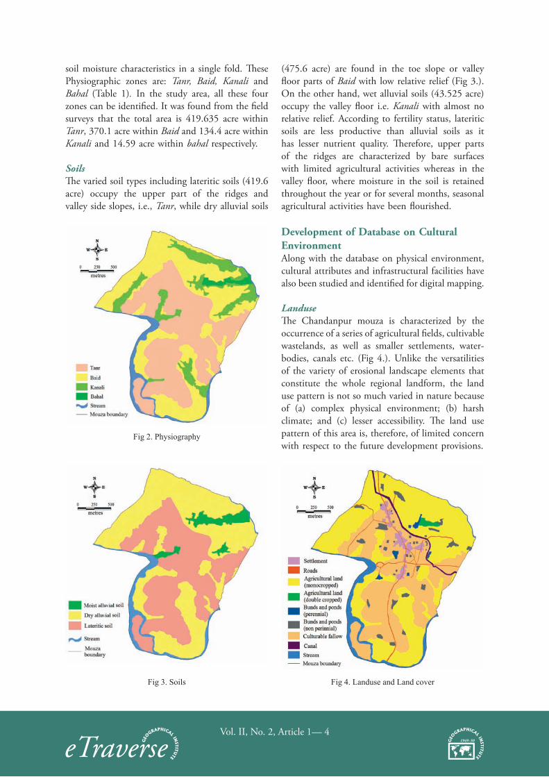
SoilsThe varied soil types including lateritic soils (419.6 acre) occupy the upper part of the ridges and valley side slopes, i.e., Tanr, while dry alluvial soils
(475.6 acre) are found in the toe slope or valley floor parts of Baid with low relative relief (Fig 3.). On the other hand, wet alluvial soils (43.525 acre) occupy the valley floor i.e. Kanali with almost no relative relief. According to fertility status, lateritic soils are less productive than alluvial soils as it has lesser nutrient quality. Therefore, upper parts of the ridges are characterized by bare surfaces with limited agricultural activities whereas in the valley floor, where moisture in the soil is retained throughout the year or for several months, seasonal agricultural activities have been flourished.
Development of Database on Cultural EnvironmentAlong with the database on physical environment, cultural attributes and infrastructural facilities have also been studied and identified for digital mapping.
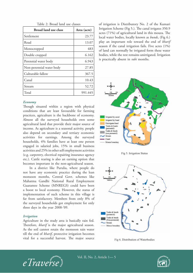
LanduseThe Chandanpur mouza is characterized by the occurrence of a series of agricultural fields, cultivable wastelands, as well as smaller settlements, water-bodies, canals etc. (Fig 4.). Unlike the versatilities of the variety of erosional landscape elements that constitute the whole regional landform, the land use pattern is not so much varied in nature because of (a) complex physical environment; (b) harsh climate; and (c) lesser accessibility. The land use pattern of this area is, therefore, of limited concern with respect to the future development provisions.
Fig 2. Physiography
Fig 3. Soils Fig 4. Landuse and Land cover
Vol. II, No. 2, Article 1— 5
Table 2: Broad land use classes
Broad land use class Area (acre)
Settlement 23.77
Road 13.07
Monocropped 483
Double cropped 6.162
Perennial water body 6.943
Non-perennial water body 27.85
Culturable fallow 367.5
Canal 10.43
Stream 52.72
Total 991.445
EconomyThough situated within a region with physical conditions that are least favourable for farming practices, agriculture is the backbone of economy. Almost all the surveyed households own some agricultural land that provide their major source of income. As agriculture is a seasonal activity, people also depend on secondary and tertiary economic activities for earnings. Among the surveyed households, 4% families have at least one person engaged in salaried jobs, 15% in small business activities and 25% in other self employment activities (e.g. carpentry, electrical repairing insurance agency etc.). Cattle rearing is also an earning option that becomes important in the non-agricultural season.
In a district like Purulia, where people do not have any economic practice during the lean monsoon months, Central Govt. schemes like Mahatma Gandhi National Rural Employment Guarantee Scheme (MNREGS) could have been a boost to local economy. However, the status of implementation of such scheme in this village is far from satisfactory. Members from only 8% of the surveyed households got employment for only three days in the year 2008-’09.
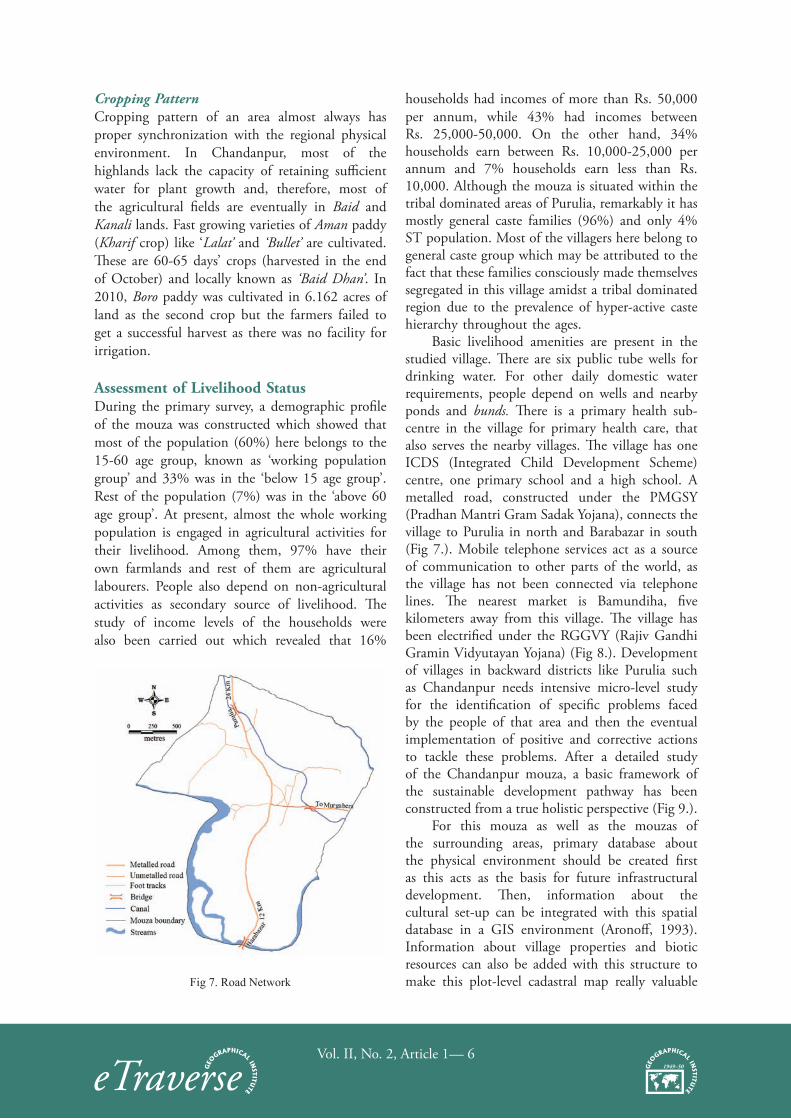
IrrigationAgriculture in the study area is basically rain fed. Therefore, kharif is the major agricultural season. As the soil cannot retain the monsoon rain water till the end of kharif, protective irrigation becomes vital for a successful harvest. The major source
of irrigation is Distributory No. 2 of the Kumari Irrigation Scheme (Fig 5.). The canal irrigates 350.9 acres (71%) of agricultural land in this mouza. The local water bodies, locally known as bunds, (Fig 6.) play an important role toward the end of kharif season if the canal irrigation fails. Five acres (1%) of land can normally be irrigated form these water bodies, while the rest remains unirrigated. Irrigation is practically absent in rabi months.
Fig 5. Irrigation Status
Fig 6. Distribution of Waterbodies
Vol. II, No. 2, Article 1— 6
Cropping PatternCropping pattern of an area almost always has proper synchronization with the regional physical environment. In Chandanpur, most of the highlands lack the capacity of retaining sufficient water for plant growth and, therefore, most of the agricultural fields are eventually in Baid and Kanali lands. Fast growing varieties of Aman paddy (Kharif crop) like ‘Lalat’ and ‘Bullet’ are cultivated. These are 60-65 days’ crops (harvested in the end of October) and locally known as ‘Baid Dhan’. In 2010, Boro paddy was cultivated in 6.162 acres of land as the second crop but the farmers failed to get a successful harvest as there was no facility for irrigation.
Assessment of Livelihood StatusDuring the primary survey, a demographic profile of the mouza was constructed which showed that most of the population (60%) here belongs to the 15-60 age group, known as ‘working population group’ and 33% was in the ‘below 15 age group’. Rest of the population (7%) was in the ‘above 60 age group’. At present, almost the whole working population is engaged in agricultural activities for their livelihood. Among them, 97% have their own farmlands and rest of them are agricultural labourers. People also depend on non-agricultural activities as secondary source of livelihood. The study of income levels of the households were also been carried out which revealed that 16%
households had incomes of more than Rs. 50,000 per annum, while 43% had incomes between Rs. 25,000-50,000. On the other hand, 34% households earn between Rs. 10,000-25,000 per annum and 7% households earn less than Rs. 10,000. Although the mouza is situated within the tribal dominated areas of Purulia, remarkably it has mostly general caste families (96%) and only 4% ST population. Most of the villagers here belong to general caste group which may be attributed to the fact that these families consciously made themselves segregated in this village amidst a tribal dominated region due to the prevalence of hyper-active caste hierarchy throughout the ages.
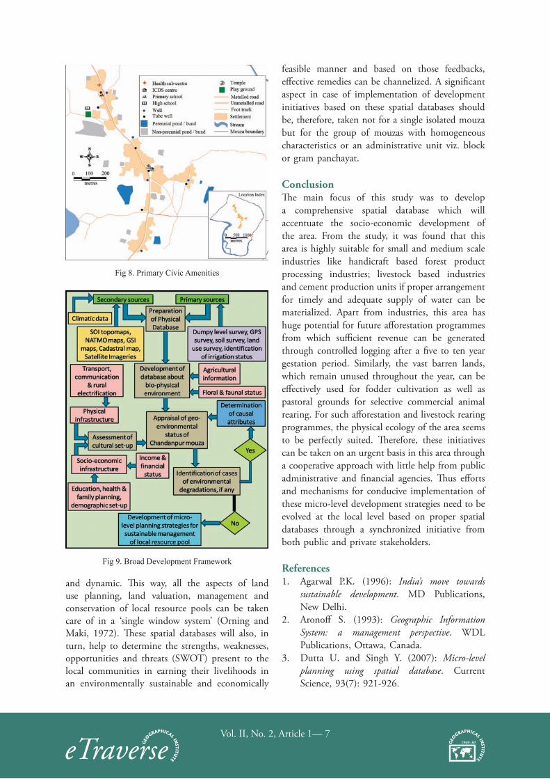
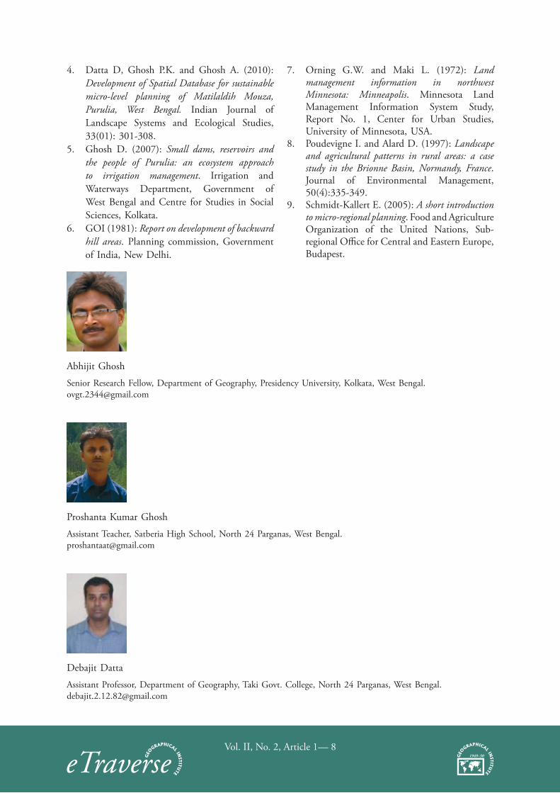
Basic livelihood amenities are present in the studied village. There are six public tube wells for drinking water. For other daily domestic water requirements, people depend on wells and nearby ponds and bunds. There is a primary health sub-centre in the village for primary health care, that also serves the nearby villages. The village has one ICDS (Integrated Child Development Scheme) centre, one primary school and a high school. A metalled road, constructed under the PMGSY (Pradhan Mantri Gram Sadak Yojana), connects the village to Purulia in north and Barabazar in south (Fig 7.). Mobile telephone services act as a source of communication to other parts of the world, as the village has not been connected via telephone lines. The nearest market is Bamundiha, five kilometers away from this village. The village has been electrified under the RGGVY (Rajiv Gandhi Gramin Vidyutayan Yojana) (Fig 8.). Development of villages in backward districts like Purulia such as Chandanpur needs intensive micro-level study for the identification of specific problems faced by the people of that area and then the eventual implementation of positive and corrective actions to tackle these problems. After a detailed study of the Chandanpur mouza, a basic framework of the sustainable development pathway has been constructed from a true holistic perspective (Fig 9.).
For this mouza as well as the mouzas of the surrounding areas, primary database about the physical environment should be created first as this acts as the basis for future infrastructural development. Then, information about the cultural set-up can be integrated with this spatial database in a GIS environment (Aronoff, 1993). Information about village properties and biotic resources can also be added with this structure to make this plot-level cadastral map really valuable Fig 7. Road Network
Vol. II, No. 2, Article 1— 7
Fig 8. Primary Civic Amenities
Fig 9. Broad Development Framework
and dynamic. This way, all the aspects of land use planning, land valuation, management and conservation of local resource pools can be taken care of in a ‘single window system’ (Orning and Maki, 1972). These spatial databases will also, in turn, help to determine the strengths, weaknesses, opportunities and threats (SWOT) present to the local communities in earning their livelihoods in an environmentally sustainable and economically
feasible manner and based on those feedbacks, effective remedies can be channelized. A significant aspect in case of implementation of development initiatives based on these spatial databases should be, therefore, taken not for a single isolated mouza but for the group of mouzas with homogeneous characteristics or an administrative unit viz. block or gram panchayat.
ConclusionThe main focus of this study was to develop a comprehensive spatial database which will accentuate the socio-economic development of the area. From the study, it was found that this area is highly suitable for small and medium scale industries like handicraft based forest product processing industries; livestock based industries and cement production units if proper arrangement for timely and adequate supply of water can be materialized. Apart from industries, this area has huge potential for future afforestation programmes from which sufficient revenue can be generated through controlled logging after a five to ten year gestation period. Similarly, the vast barren lands, which remain unused throughout the year, can be effectively used for fodder cultivation as well as pastoral grounds for selective commercial animal rearing. For such afforestation and livestock rearing programmes, the physical ecology of the area seems to be perfectly suited. Therefore, these initiatives can be taken on an urgent basis in this area through a cooperative approach with little help from public administrative and financial agencies. Thus efforts and mechanisms for conducive implementation of these micro-level development strategies need to be evolved at the local level based on proper spatial databases through a synchronized initiative from both public and private stakeholders.
References 1. Agarwal P.K. (1996): India’s move towards
sustainable development. MD Publications, New Delhi.
2. Aronoff S. (1993): Geographic Information System: a management perspective. WDL Publications, Ottawa, Canada.
3. Dutta U. and Singh Y. (2007): Micro-level planning using spatial database. Current Science, 93(7): 921-926.
Vol. II, No. 2, Article 1— 8
4. Datta D, Ghosh P.K. and Ghosh A. (2010): Development of Spatial Database for sustainable micro-level planning of Matilaldih Mouza, Purulia, West Bengal. Indian Journal of Landscape Systems and Ecological Studies, 33(01): 301-308.
5. Ghosh D. (2007): Small dams, reservoirs and the people of Purulia: an ecosystem approach to irrigation management. Irrigation and Waterways Department, Government of West Bengal and Centre for Studies in Social Sciences, Kolkata.
6. GOI (1981): Report on development of backward hill areas. Planning commission, Government of India, New Delhi.
7. Orning G.W. and Maki L. (1972): Land management information in northwest Minnesota: Minneapolis. Minnesota Land Management Information System Study, Report No. 1, Center for Urban Studies, University of Minnesota, USA.
8. Poudevigne I. and Alard D. (1997): Landscape and agricultural patterns in rural areas: a case study in the Brionne Basin, Normandy, France. Journal of Environmental Management, 50(4):335-349.
9. Schmidt-Kallert E. (2005): A short introduction to micro-regional planning. Food and Agriculture Organization of the United Nations, Sub-regional Office for Central and Eastern Europe, Budapest.
Abhijit Ghosh
Senior Research Fellow, Department of Geography, Presidency University, Kolkata, West Bengal. [email protected]
Proshanta Kumar Ghosh
Assistant Teacher, Satberia High School, North 24 Parganas, West Bengal. [email protected]
Debajit Datta
Assistant Professor, Department of Geography, Taki Govt. College, North 24 Parganas, West Bengal. [email protected]


![Spatial Databases - Semantic Scholar · Spatial Databases 1.1 Introduction 1.1.1 Spatial Database Spatial database management systems [43, 58, 120, 119, 97, 74] aim at the effective](https://img.pdfslide.net/doc/110x75/5edc6310ad6a402d666706d6/spatial-databases-semantic-scholar-spatial-databases-11-introduction-111-spatial.jpg)