Embed Size (px)
Citation preview
Development of the GeoPortal for Georgian Forests Final Technical Report Levan Natsvlishvili Tbilisi 2016
This publication has been produced with the assistance of the European Union. The content, findings, interpretations, and conclusions of this publication are the sole responsibility of the FLEG II (ENPI East) Programme Team (www.enpi-fleg.org) and can in no way be taken to reflect the views of the European Union. The views expressed do not necessarily reflect those of the Implementing Organizations.
Contents 1. Introduction ......................................................................................................................... 3 2. Goals and Objectives ........................................................................................................... 3 3. Description of the GeoPortal ............................................................................................... 4 3.1. Background: Introduction to Spatial data Infrastructure (SDI) ........................................... 4 3.2. Technical issues for GeoForestPortal .................................................................................. 5 3.2.1. MapServer ........................................................................................................................ 5 3.2.2. PostgreSQL ....................................................................................................................... 7 3.2.3. PostGIS ............................................................................................................................. 7 3.2.4. OpenLayers ...................................................................................................................... 8 3.2.5. QuantumGIS ..................................................................................................................... 8 4. Maps (Spatial data) of Geoportal of Forest in Georgia ..................................................... 11 4.1. Background on maps ......................................................................................................... 11 4.2. General maps on Forests ...................................................................................................... 12 4.3. Deforestation Maps .............................................................................................................. 12 4.3. Disease Maps ..................................................................................................................... 13 4.4. Firewood ............................................................................................................................ 13 4.5. Forest dependency ............................................................................................................ 14 5. WEB GIG training and the GeoForestPortal Training Manual ........................................... 15 6. Presentation of the GeoForestPortal manual to the Ministry of Environment and Nature Resources Protection of Georgia ................................................................................................. 16 References ................................................................................................................................... 18
2
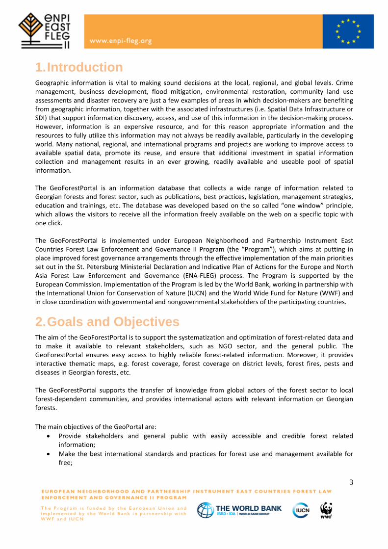
1. Introduction Geographic information is vital to making sound decisions at the local, regional, and global levels. Crime management, business development, flood mitigation, environmental restoration, community land use assessments and disaster recovery are just a few examples of areas in which decision-makers are benefiting from geographic information, together with the associated infrastructures (i.e. Spatial Data Infrastructure or SDI) that support information discovery, access, and use of this information in the decision-making process. However, information is an expensive resource, and for this reason appropriate information and the resources to fully utilize this information may not always be readily available, particularly in the developing world. Many national, regional, and international programs and projects are working to improve access to available spatial data, promote its reuse, and ensure that additional investment in spatial information collection and management results in an ever growing, readily available and useable pool of spatial information. The GeoForestPortal is an information database that collects a wide range of information related to Georgian forests and forest sector, such as publications, best practices, legislation, management strategies, education and trainings, etc. The database was developed based on the so called “one window” principle, which allows the visitors to receive all the information freely available on the web on a specific topic with one click. The GeoForestPortal is implemented under European Neighborhood and Partnership Instrument East Countries Forest Law Enforcement and Governance II Program (the “Program”), which aims at putting in place improved forest governance arrangements through the effective implementation of the main priorities set out in the St. Petersburg Ministerial Declaration and Indicative Plan of Actions for the Europe and North Asia Forest Law Enforcement and Governance (ENA-FLEG) process. The Program is supported by the European Commission. Implementation of the Program is led by the World Bank, working in partnership with the International Union for Conservation of Nature (IUCN) and the World Wide Fund for Nature (WWF) and in close coordination with governmental and nongovernmental stakeholders of the participating countries.
2. Goals and Objectives The aim of the GeoForestPortal is to support the systematization and optimization of forest-related data and to make it available to relevant stakeholders, such as NGO sector, and the general public. The GeoForestPortal ensures easy access to highly reliable forest-related information. Moreover, it provides interactive thematic maps, e.g. forest coverage, forest coverage on district levels, forest fires, pests and diseases in Georgian forests, etc. The GeoForestPortal supports the transfer of knowledge from global actors of the forest sector to local forest-dependent communities, and provides international actors with relevant information on Georgian forests. The main objectives of the GeoPortal are:
• Provide stakeholders and general public with easily accessible and credible forest related information;
• Make the best international standards and practices for forest use and management available for free;
3
• Ensure that the portal is set up to allow for information flow in two directions: ‘global to local’ and ‘local to global’ to allow the opportunities for improved knowledge transfer;
• Make available forest-related maps with different spatial and temporal scales and as well as the feature to view different thematic areas;
• Make spatial information on forests available through standard Internet connections and resolve common issues with the availability, systematization and optimization of commonly available data.
3. Description of the GeoPortal 3.1. Background: Introduction to Spatial data Infrastructure (SDI)
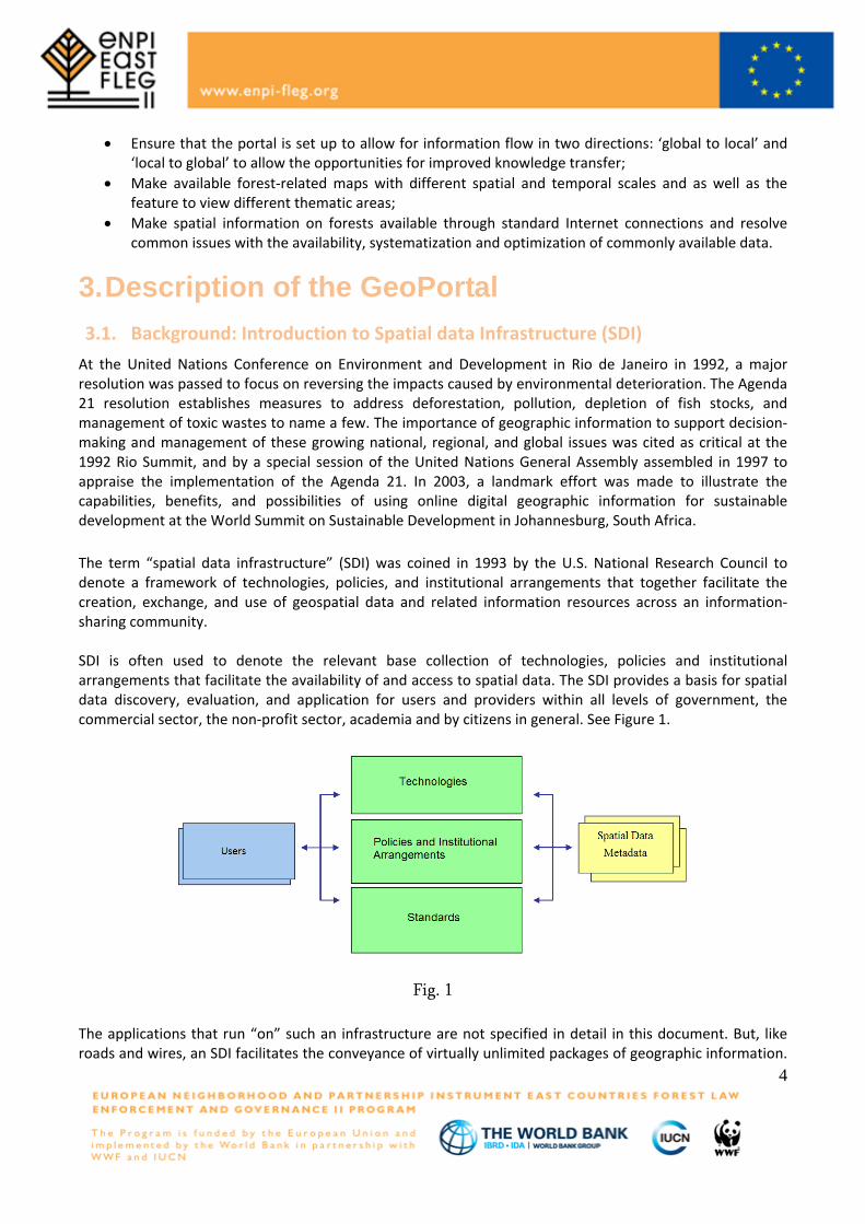
At the United Nations Conference on Environment and Development in Rio de Janeiro in 1992, a major resolution was passed to focus on reversing the impacts caused by environmental deterioration. The Agenda 21 resolution establishes measures to address deforestation, pollution, depletion of fish stocks, and management of toxic wastes to name a few. The importance of geographic information to support decision-making and management of these growing national, regional, and global issues was cited as critical at the 1992 Rio Summit, and by a special session of the United Nations General Assembly assembled in 1997 to appraise the implementation of the Agenda 21. In 2003, a landmark effort was made to illustrate the capabilities, benefits, and possibilities of using online digital geographic information for sustainable development at the World Summit on Sustainable Development in Johannesburg, South Africa. The term “spatial data infrastructure” (SDI) was coined in 1993 by the U.S. National Research Council to denote a framework of technologies, policies, and institutional arrangements that together facilitate the creation, exchange, and use of geospatial data and related information resources across an information-sharing community. SDI is often used to denote the relevant base collection of technologies, policies and institutional arrangements that facilitate the availability of and access to spatial data. The SDI provides a basis for spatial data discovery, evaluation, and application for users and providers within all levels of government, the commercial sector, the non-profit sector, academia and by citizens in general. See Figure 1.
Fig. 1
The applications that run “on” such an infrastructure are not specified in detail in this document. But, like roads and wires, an SDI facilitates the conveyance of virtually unlimited packages of geographic information.
4
An SDI must be more than a single data set or database; an SDI hosts geographic data and attributes, sufficient documentation (metadata), a means to discover, visualize, and evaluate the data (catalogues and Web mapping), and some method to provide access to the geographic data. Beyond this are additional services or software to support applications of the data. To make an SDI functional, it must also include the organizational agreements needed to coordinate and administer it on a local, regional, national, and or trans-national scale. Although the core SDI concept includes within its scope neither base data collection activities or myriad applications built upon it, the infrastructure provides the ideal environment to connect applications to data – influencing both data collection and applications construction through minimal appropriate standards and policies. The creation of specific organizations or programs for developing or overseeing the development of SDI, particularly by government at various scales can be seen as the logical extension of the long practice of coordinating the building of other infrastructures necessary for ongoing development, such as transportation or telecommunication networks. Geoportals are important for effective use of geographic information systems (GIS) and a key element of Spatial Data Infrastructure (SDI).
3.2. Technical issues for GeoForestPortal GeoPortal of Forest in Georgia http://enpi-fleg.ge/forestgeoportal/ is based on several open source projects, such as:
1. Map Server 2. PostgreSQL 3. OpenLayers 4. QuantumGIS
3.2.1. MapServer MapServer is a popular Open Source project the purpose of which is to display dynamic spatial maps over the Internet. Some of its major features include:
• support to display and querying of hundreds of raster, vector, and database formats • ability to run on various operating systems (Windows, Linux, Mac OS X, etc.) • support to popular scripting languages and development environments (PHP, Python, Perl, Ruby,
Java, .NET) • on-the-fly projections • high quality rendering • fully customizable application output • many ready-to-use Open Source application environments
In its most basic form, MapServer is a CGI program that sits inactive on your Web server. When a request is sent to MapServer, it uses information passed in the request URL and the Mapfile to create an image of the requested map. The request may also return images for legends, scale bars, reference maps, and values passed as CGI variables.
5
MapScript provides a scripting interface for MapServer for the construction of Web and stand-alone applications. MapScript can be used independently of CGI MapServer, and it is a loadable module that adds MapServer capability to your favorite scripting language. MapScript currently exists in PHP, Perl, Python, Ruby, Tcl, Java, and .NET flavors. Anatomy of a MapServer Application A simple MapServer application consists of:
• Map File - a structured text configuration file for MapServer application. It defines the area of the map, tells the MapServer program where the data is and where to output images. It also defines map layers, including their data source, projections, and symbology. It must have a .map extension or MapServer will notrecognize it.
• Geographic Data - MapServer can utilize many geographic data source types. The default format is
the ESRI shapefile.
• HTML Pages - the interface between the user and MapServer. They normally sit in Web root. In it’s simplest form, MapServer can be called to place a static map image on a html page. To make the map interactive, the image is placed in an html form on a page.
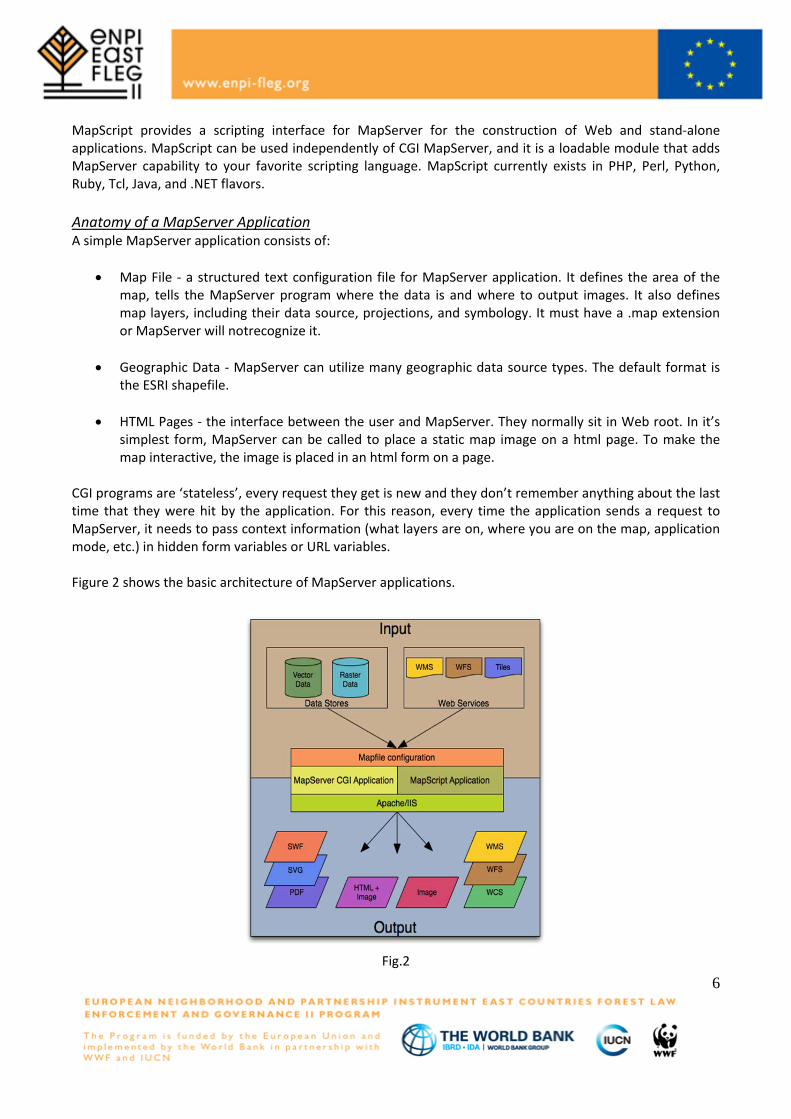
CGI programs are ‘stateless’, every request they get is new and they don’t remember anything about the last time that they were hit by the application. For this reason, every time the application sends a request to MapServer, it needs to pass context information (what layers are on, where you are on the map, application mode, etc.) in hidden form variables or URL variables. Figure 2 shows the basic architecture of MapServer applications.
Fig.2
6
Initialization File - uses a form with hidden variables to send an initial query to the http server and MapServer. This form could be placed on another page or be replaced by passing the initialization information as variables in a URL. Template File - controls how the maps and legends output by MapServer will appear in the browser. By referencing MapServer CGI variables in the template html, one allow MapServer to populate them with values related to the current state of the application (e.g. map image name, reference image name, map extent, etc.) as it creates the html page for the browser to read. The template also determines how the user can interact with the MapServer application (browse, zoom, pan, and query).
• MapServer CGI - The binary or executable file that receives requests and returns images, data, etc. It sits in the cgi-bin or scripts directory of the http server. TheWeb server user must have execute rights for the directory that it sits in, and for security reasons, it should not be in the web root. By default, this program is called mapserv.
• HTTP Server - serves up the html pages when hit by the user’s browser. A working HTTP (Web)
server is needed, such as Apache or Microsoft Internet Information Server, on the machine on which you are installing MapServer.
Windows Installation Download MS4W for free here: http://maptools.org/dl/ms4w/ms4w-3.0.1-setup.exe The basic MS4W package installs a preconfigured Web Server environment that includes the following components: Apache HTTP Server version 2.2.17, PHP version 5.3.5, MapServer CGI 5.6.6, MapScript 5.6.6 (CSharp, Java, PHP, Python), Includes support for Oracle 11g, and SDE data (if you have associated client/dlls), MrSID support built-in, GDAL/OGR 1.8.0 and Utilities, MapServer Utilities, PROJ Utilities, Shapelib Utilities, Shp2tile Utility, Shpdiff Utility, AVCE00 Utilities, OGR/PHP Extension 1.0.0, OWTChart 1.2.0
3.2.2. PostgreSQL The object-relational database management system now known as PostgreSQL is derived from the POSTGRES package written at the University of California at Berkeley. With over two decades of development behind it, PostgreSQL is now the most advanced open-source database available anywhere.
3.2.3. PostGIS PostGIS adds support for geographic objects to the PostgreSQL object-relational database. In effect, PostGIS "spatially enables" the PostgreSQL server, allowing it to be used as a backend spatial database for geographic information systems (GIS), much like ESRI's SDE or Oracle's Spatial extension. PostGIS follows the OpenGIS "Simple Features Specification for SQL" and has been certified as compliant with the "Types and Functions" profile. PostGIS has been developed by Refractions Research as a project in open source spatial database technology. PostGIS is released under the GNU General Public License. We continue to develop PostGIS, and have added user interface tools, basic topology support, data validation, coordinate transformation,
7

programming APIs and much more. The list of future projects includes full topology support, raster support, networks and routing, three dimensional surfaces, curves and splines and other features. Windows Installation The Windows installer for PostgreSQL includes the PostgreSQL server, pgAdmin III; a graphical tool for managing and developing the databases, and StackBuilder; a package manager that can be used to download and install additional PostgreSQL applications and drivers. One click installer The one click installer is designed to be as straightforward as possible and the fastest way to get up and running with PostgreSQL on Windows. Download PostgreSQL for free here: http://www.enterprisedb.com/products/pgdownload.do#windows
3.2.4. OpenLayers OpenLayers makes it easy to put a dynamic map in any web page. It can display map tiles and markers loaded from any source. OpenLayers has been developed to further use of geographic information of all kinds. OpenLayers is completely free, Open Source JavaScript, released under a BSD-style License (also known as the Clear BSD).
For Developers! OpenLayers is a pure JavaScript library for displaying map data in most modern web browsers, with no server-side dependencies. OpenLayers implements a (still-developing) JavaScript API for building rich web-based geographic applications, similar to the Google Maps and MSN Virtual Earth APIs, with one important difference - OpenLayers is Free Software, developed for and by the Open Source software community.
Furthermore, OpenLayers implements industry-standard methods for geographic data access, such as the OpenGIS Consortium's Web Mapping Service (WMS) and Web Feature Service (WFS) protocols. Under the hood, OpenLayers is written in object-oriented JavaScript, using components from Prototype.js and the Rico library. The OpenLayers code base already has hundreds of unit tests, via the Test. AnotherWay framework.
As a framework, OpenLayers is intended to separate map tools from map data so that all the tools can operate on all the data sources. This separation breaks the proprietary silos that earlier GIS revolutions have taught civilization to avoid. The mapping revolution on the public Web should benefit from the experience of history.
Windows Installation Download OpenLayers for free here: http://openlayers.org/download/OpenLayers-2.10.zip
3.2.5. QuantumGIS QGIS offers many common GIS functionalities provided by core features and plugins. As a short summary they are presented in six categories to gain a first insight. View data This category gives the possibility to view and overlay vector and raster data in different formats and projections without conversion to an internal or common format. Supported formats include:
8
– Spatially-enabled PostgreSQL tables using PostGIS, vector formats supported by the installed OGR library, including ESRI shapefiles, MapInfo, SDTS and GML. – Raster and imagery formats supported by the installed GDAL (Geospatial Data Abstraction Library) library, such as GeoTiff, Erdas Img., ArcInfo Ascii Grid, JPEG, PNG. – SpatiaLite databases, – GRASS raster and vector data from GRASS databases (location/mapset), – Online spatial data served as OGC-compliant Web Map Service (WMS) or Web Feature Service (WFS), – OpenStreetMap data. Explore data and compose maps This category gives the possibility to compose maps and interactively explore spatial data with a friendly GUI. The many helpful tools available in the GUI include: – map composers – overview panel – spatial bookmarks – identify/select features – edit/view/search attributes – feature labeling – change vector and raster symbology – add a graticule layer - now via fTools plugin – decorate your map with a north arrow scale bar and copyright label – save and restore projects Create, edit, manage and export data This category gives the possibility to create, edit, manage and export vector maps in several formats. Raster data have to be imported into GRASS to be able to edit and export them into other formats. QGIS offers the following: – digitizing tools for OGR supported formats and GRASS vector layer – create and edit shapefiles and GRASS vector layers – geocode images with the Georeferencer plugin – GPS tools to import and export GPX format, and convert other GPS formats to GPX or down/upload directly to a GPS unit (on Linux, usb: has been added to list of GPS devices) – visualize and edit OpenStreetMap data – create PostGIS layers from shapefiles with the SPIT plugin – improved handling of PostGIS tables – manage vector attribute tables with the new attribute table or Table Manager plugin save screenshots as georeferenced images
9
Analyse data This category gives the possibility to perform spatial data analysis on PostgreSQL/PostGIS and other OGR supported formats using the Tools Python plugin. QGIS currently offers vector analysis, sampling, geoprocessing, geometry and database management tools. The integrated GRASS tools can also be used, which include the complete GRASS functionality of more than 300 modules. Publish maps on the Internet QGIS can be used to export data to a mapfile and to publish them on the Internet using a webserver with UMN MapServer installed. QGIS can also be used as a WMS or WFS client, and as WMS server. Extend QGIS functionality through plugins QGIS can be adapted to special needs with the extensible plugin architecture. QGIS provides libraries that can be used to create plugins. One can even create new applications with C++ or Python! Core Plugins 1. Add Delimited Text Layer (Loads and displays delimited text files containing x,y coordinates) 2. Coordinate Capture (Capture mouse coordinates in different CRS) 3. Decorations (Copyright Label, North Arrow and Scale bar) 4. Diagram Overlay (Placing diagrams on vector layer) 5. Dxf2Shp Converter (Convert DXF to Shape) 6. GPS Tools (Loading and importing GPS data) 7. GRASS (GRASS GIS integration) 8. Georeferencer GDAL (Adding projection information to raster using GDAL) 9. Interpolation plugin (interpolate based on vertices of a vector layer) 10. Mapserver Export (Export QGIS project file to a MapServer map file) 11. OGR Layer Converter (Translate vector layer between formats) 12. OpenStreetMap plugin (Viewer and editor for openstreetmap data) 13. Oracle Spatial GeoRaster support 14. Python Plugin Installer (Download and install QGIS python plugins) 15. Quick Print (Print a map with minimal effort) 16. Raster terrain analysis (Raster based terrain analysis) 17. SPIT (Import Shapefile to PostgreSQL/PostGIS) 18. WFS Plugin (Add WFS layers to QGIS canvas) 19. eVIS (Event Visualization Tool) 20. fTools (Tools for vector data analysis and management) 21. Python Console (Access QGIS environment) 22. GDAL Tools External Python Plugins QGIS offers a growing number of external python plugins that are provided by the community. These plugins reside in the official PyQGIS repository, and can be easily installed using the Python Plugin Installer Installation Installation of QGIS is very simple. Standard installer packages are available for MS Windows and Mac OSX. For many flavors of GNU/Linux binary packages (rpm and deb) or software repositories to add to the
10
installation manager are provided. Get the latest information on binary packages at the QGIS website at http://qgis.osgeo.org/download/. Windows Installation Download QGIS for free here: http://qgis.org/downloads/
4. Maps (Spatial data) of Geoportal of Forest in Georgia 4.1. Background on maps
All thematic maps are interactive with several zoom levels and consist of:
• Base layers: Open street map, Google physical, Google Streets, Google hybrid, Google satellite; • Overlays - different for each map, for example for Boxwood disease map it is a layer visualized as
points; • Legend; • Information section - By clicking on the object on the map you are getting information for this
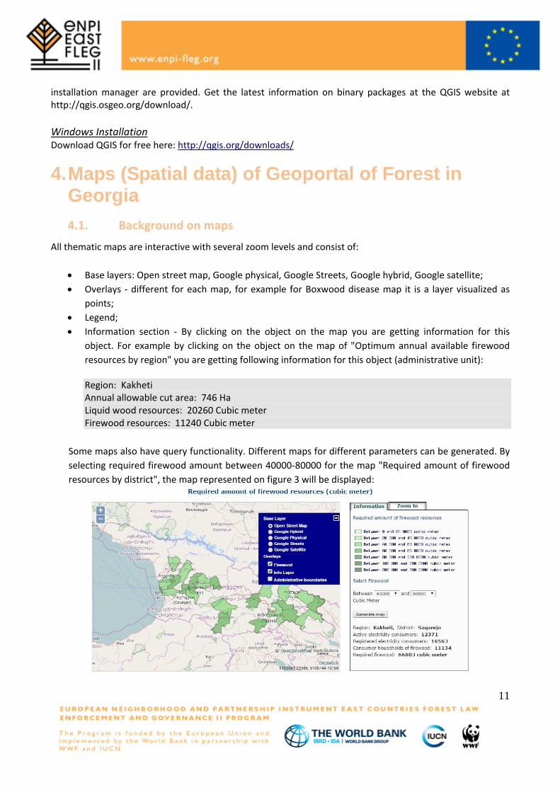
object. For example by clicking on the object on the map of "Optimum annual available firewood resources by region" you are getting following information for this object (administrative unit):
Region: Kakheti Annual allowable cut area: 746 Ha Liquid wood resources: 20260 Cubic meter Firewood resources: 11240 Cubic meter
Some maps also have query functionality. Different maps for different parameters can be generated. By selecting required firewood amount between 40000-80000 for the map "Required amount of firewood resources by district", the map represented on figure 3 will be displayed:
11
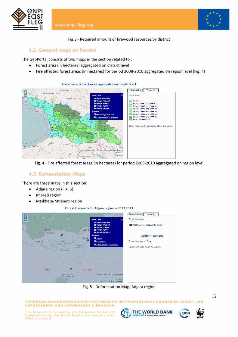
Fig.3 - Required amount of firewood resources by district
4.2. General maps on Forests The GeoPortal consists of two maps in the section related to :
• Forest area (in hectares) aggregated on district level • Fire affected forest areas (in hectares) for period 2008-2010 aggregated on region level (Fig. 4)
Fig. 4 - Fire affected forest areas (in hectares) for period 2008-2010 aggregated on region level
4.3. Deforestation Maps There are three maps in this section:
• Adjara region (Fig. 5) • Imereti region • Mtskheta-Mtianeti region
Fig. 5 - Deforestation Map, Adjara region
12
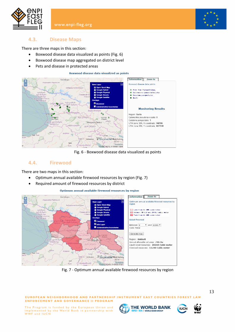
4.3. Disease Maps There are three maps in this section:
• Boxwood disease data visualized as points (Fig. 6) • Boxwood disease map aggregated on district level • Pets and disease in protected areas
Fig. 6 - Boxwood disease data visualized as points
4.4. Firewood There are two maps in this section:
• Optimum annual available firewood resources by region (Fig. 7) • Required amount of firewood resources by district
Fig. 7 - Optimum annual available firewood resources by region
13
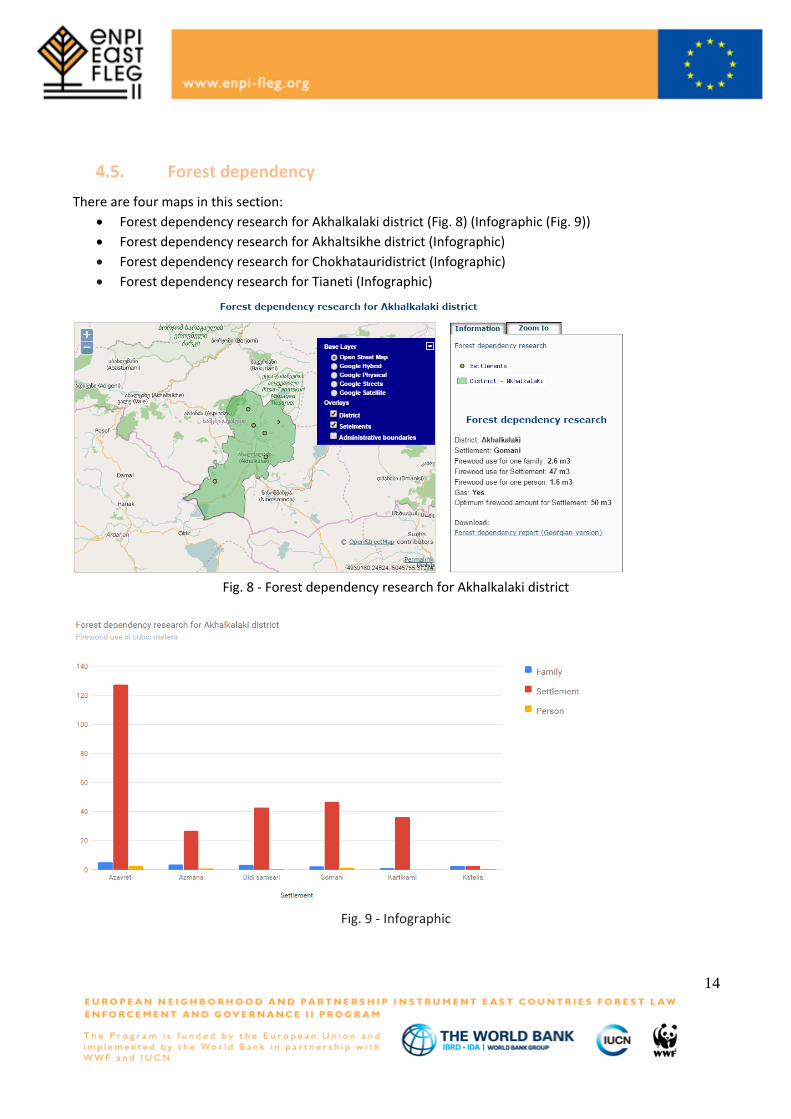
4.5. Forest dependency There are four maps in this section:
• Forest dependency research for Akhalkalaki district (Fig. 8) (Infographic (Fig. 9)) • Forest dependency research for Akhaltsikhe district (Infographic) • Forest dependency research for Chokhatauridistrict (Infographic) • Forest dependency research for Tianeti (Infographic)
Fig. 8 - Forest dependency research for Akhalkalaki district
Fig. 9 - Infographic
14
All data for maps was collected and provided by FLEG experts, stored in PostgreSQL spatial tables and can be requested with WFS requests from WMS Map server as a raw data. There is easy possibility to transfer web site and all spatial and non-spatial data to a new server. Geoportal of forest in Georgia is online: http://enpi-fleg.ge/geoforestportal/
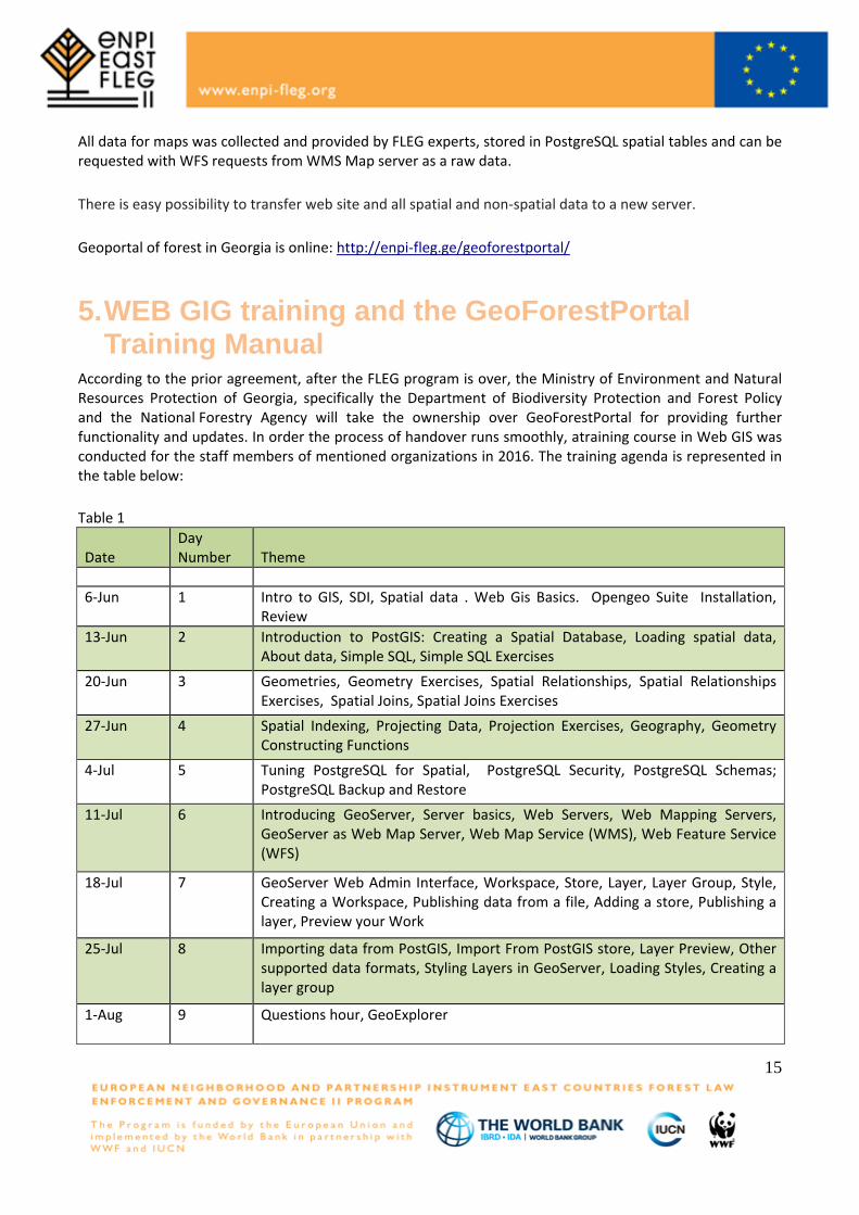
5. WEB GIG training and the GeoForestPortal Training Manual
According to the prior agreement, after the FLEG program is over, the Ministry of Environment and Natural Resources Protection of Georgia, specifically the Department of Biodiversity Protection and Forest Policy and the National Forestry Agency will take the ownership over GeoForestPortal for providing further functionality and updates. In order the process of handover runs smoothly, atraining course in Web GIS was conducted for the staff members of mentioned organizations in 2016. The training agenda is represented in the table below: Table 1
Date Day Number Theme
6-Jun 1 Intro to GIS, SDI, Spatial data . Web Gis Basics. Opengeo Suite Installation, Review
13-Jun 2 Introduction to PostGIS: Creating a Spatial Database, Loading spatial data, About data, Simple SQL, Simple SQL Exercises
20-Jun 3 Geometries, Geometry Exercises, Spatial Relationships, Spatial Relationships Exercises, Spatial Joins, Spatial Joins Exercises
27-Jun 4 Spatial Indexing, Projecting Data, Projection Exercises, Geography, Geometry Constructing Functions
4-Jul 5 Tuning PostgreSQL for Spatial, PostgreSQL Security, PostgreSQL Schemas; PostgreSQL Backup and Restore
11-Jul 6 Introducing GeoServer, Server basics, Web Servers, Web Mapping Servers, GeoServer as Web Map Server, Web Map Service (WMS), Web Feature Service (WFS)
18-Jul 7 GeoServer Web Admin Interface, Workspace, Store, Layer, Layer Group, Style, Creating a Workspace, Publishing data from a file, Adding a store, Publishing a layer, Preview your Work
25-Jul 8 Importing data from PostGIS, Import From PostGIS store, Layer Preview, Other supported data formats, Styling Layers in GeoServer, Loading Styles, Creating a layer group
1-Aug
9 Questions hour, GeoExplorer
15
8-Aug 10 Questions hour, Case study 15-Aug 11 Intro to Quantum GIS (QGIS). Plugins - MapServer Export, SPIT. 22-Aug 12 Intro to "MapServer". Map file review. 29-Aug 13 MapServe Exercises - PostGIS data visualization. 5-Sep 14 Intro to Openlayers. Creating a basic OpenLayers map. Adding Layers and
Controls.
Beside this training, GeoForestPortal installation DVD with all necessary information and data was prepared for GeoPortal deployment and functionality: GeoPortal deployment manual, Training course reader, Geoforestportal general description document, Geoforestportal Spatial data representation document, PostgreSQL spatial database backup, web site MySQL database backup, web site files and raw spatial data files.
GeoPortal deployment manual contains information about geoportal software download, installation and configuration details. How to control enpi-fleg.ge domain registration, create zone enpi-fleg.ge on DNS server and make necessarily records for this zone for providing working URL: http://enpi-fleg.ge/geoforestportal/
6. Presentation of the GeoForestPortal manual tothe Ministry of Environment and NatureResources Protection of Georgia
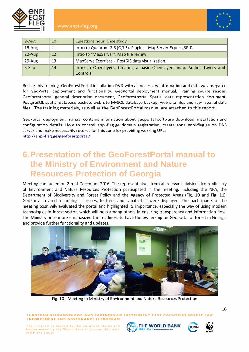
Meeting conducted on 2th of December 2016. The representatives from all relevant divisions from Ministry of Environment and Nature Resources Protection participated in the meeting, including the NFA, the Department of Biodiversity and Forest Policy and the Agency of Protected Areas (Fig. 10 and Fig. 11). GeoPortal related technological issues, features and capabilities were displayed. The participants of the meeting positively evaluated the portal and highlighted its importance, especially the way of using modern technologies in forest sector, which will help among others in ensuring transparency and information flow. The Ministry once more emphasized the readiness to have the ownership on Geoportal of forest in Georgia and provide further functionality and updates.
Fig. 10 - Meeting in Ministry of Environment and Nature Resources Protection
16
The training materials, as well as the GeoForestPortal manual are attached to this report.
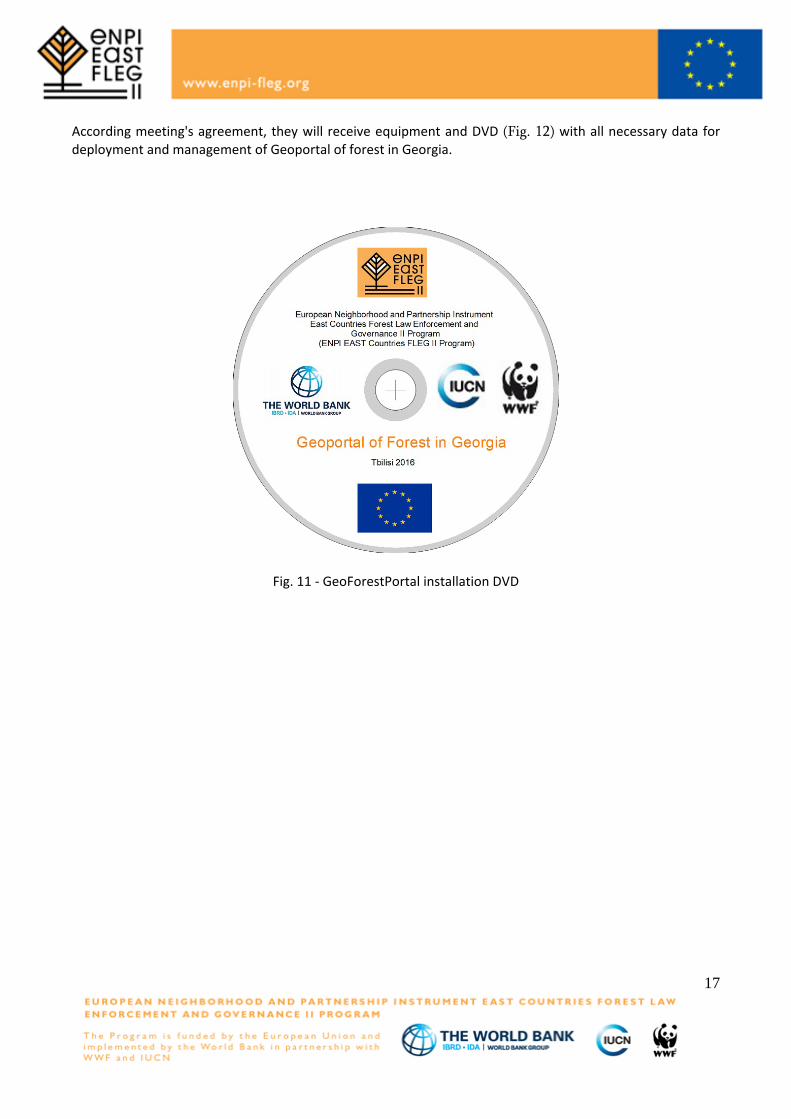
According meeting's agreement, they will receive equipment and DVD (Fig. 12) with all necessary data for deployment and management of Geoportal of forest in Georgia.
Fig. 11 - GeoForestPortal installation DVD
17
References 1. PostgreSQL 8.4.6 Documentation - by The PostgreSQL Global Development Group, Copyright © 1996-2009 2. MapServer Documentation Release 5.6.6 – by The MapServer Team, February 03, 2011 3. Quantum GIS User Guide Version 1.6.0 ’Copiapó’ - by Quantum GIS Development TeamCopyright c 2004 - 2010 5. Spatial Data infrastructure cookbook V.1 – 5 July 2011
18
A
A
About The Forest L(ENPI) East Program aimcommit to a and legal amanagementProgram wilimproved forAzerbaijan, Bhttp://www.e
Projec
FLEGLaw EnforcemCountries Pr
ms to implemtime-bound a
and administ and good fol test and drest governanBelarus, Geornpi-fleg.org
ct Part
G II (ENment and Gorogram supp
ment the 200action plan; atrative strucorest governademonstrate nce practicesrgia, Moldova
tner
NPI Eaovernance (Forts particip
05 St. Petersat the nationtures; and
ance in the pbest practic
s at the field-a, Russia, and
EUROPEAThe EuropeEuropeAid Commissionaid throughowith a focusproactive plaand econompreserving nhttp://ec.euro
WORLD BThe World Bits 188 memowned by thpower withinissues. TheInternationalDevelopmenFinance Corthe Internatiplays a distdecreasing tpercent, andpercent for ehttp://www.wo
IUCN IUCN, Internsolutions to focuses on vof its use, andevelopmenworld, and policy, lawsenvironmentalmost 11,00over 1,000 saround the wwww.iucn.org
WWF WWF is onorganizationcountries. Wand to buildworld’s biolosustainable, www.panda.o
ast) PrFLEG) II Europating countrsburg FLEG al level the Pimprove kno
participating es for susta-level on a pid Ukraine. Th
AN COMMISan Union is thDevelopment a, is responsible
out the world. Es on ensuring ayer in the deve
mic developmennatural resourceopa.eu/index_e
BANKBank Group is onmber-countries.
e governments n the organizatie World Bank l Bank for Rec
nt Association (rporation (IFC);onal Centre fortinct role in thethe percentage d promote shareevery country. Forldbank.org, htt
national Union our most press
valuing and connd deploying nat. IUCN suppobrings governm
s and best ptal organisation00 volunteer ex
staff in 45 officesworld. g
ne of the worlds, with almost
WWF’s mission id a future in whogical diversity,and promoting
org
rogramopean Neighbries’ forest gMinisterial D
Program will owledge of countries, an
ainable foresilot basis. Pahe Program is
SSION he world’s largeand Cooperatioe for designing EuropeAid delivthe quality of
elopment field, Ent and tackle us. n.htm
ne of the world’sThe organizatioof member natons on all mattGroup compris
construction andIDA), which tog the Multilaterar Settlement of e World Bank of people living
ed prosperity byor additional infp://www.ifc.org, h
for Conservatiosing environmenserving natureature-based solurts scientific re
ments, NGOs, tractice. IUCN , with more thaxperts in some s and hundreds
d’s largest and5 million suppos to stop the de
hich humans liv, ensuring thatthe reduction of
m bourhood angovernance. ADeclaration areview or revand suppor
nd at the subst managemearticipating cs funded by t
est donor of ofon, a Directora
European deveers aid throughEU aid and itsEuropeAid promniversal issues
s largest sourceons that make ions, which havters, including pses five closeld Developmentgether form theal Investment GInvestment DisGroup’s missio
g on less than $y fostering the information pleasehttp://www.miga.
on of Nature, hnt and develop, ensuring effecutions to global esearch, managthe UN and cois the world’
an 1,200 govern160 countries.of partners in p
d most respecorters and a gloegradation of thve in harmony wt the use of ref pollution and w
d PartnershiAt the regioand support vise forest sert for sustab-national (loent and the ountries inclthe European
fficial developmate General ofelopment policy
h a set of finans effectiveness.motes good gove, such as fight
es of knowledgeup the World B
ve the ultimate dpolicy, financial y associated i
t (IBRD) and th World Bank; t
Guarantee Agensputes (ICSID). on to end extre$1.25 a day to ncome growth oe visit: org
helps the worldment challenge
ctive and equitachallenges in clges field projecompanies togets oldest and
nment and NGO IUCN’s work i
public, NGO and
ted independenbal network act
he planet’s natuwith nature, by enewable naturwasteful consum
ip Instrumennal level, thecountries to
ector policiesinable fores
ocal) level thefeasibility oude Armenia
n Union.
ment assistancef the Europeany and deliveringcial instruments An active andernance, humaning hunger and
e and funding foBank Group aredecision-makingor membership
institutions: thehe Internationahe Internationacy (MIGA); andEach institution
eme poverty byno more than 3
of the bottom 40
find pragmatices. IUCN’s workable governancelimate, food andcts all over thether to develop
largest globaO members andis supported byd private sectors
nt conservationtive in over 100
ural environmenconserving the
ral resources ismption.
t e o s t e f
a,
.ng sdn d
r e g p ell
dny 30
cke d ep l
dy s
n 0te s