Embed Size (px)
Citation preview
This policy is subject to any specific provisions of the Municipal Government Act or other relevant legislation or Union Agreement.
CITY POLICY
Page 1 of 19
POLICY NUMBER: C542A
REFERENCE: ADOPTED BY:
City Council 26 February 1985 City Council 11 October 2016
City Council 17 February 2010
SUPERSEDES: Top-of-the-Bank Public Roadway
Policy
PREPARED BY: Sustainable Development DATE: 28 September 2016
TITLE: Development Setbacks From River Valley/Ravine Crests
Policy Statement:
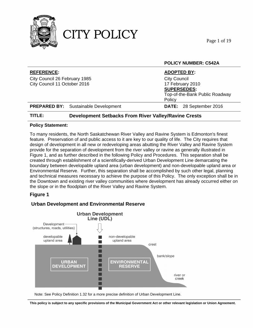
To many residents, the North Saskatchewan River Valley and Ravine System is Edmonton's finest feature. Preservation of and public access to it are key to our quality of life. The City requires that design of development in all new or redeveloping areas abutting the River Valley and Ravine System provide for the separation of development from the river valley or ravine as generally illustrated in Figure 1, and as further described in the following Policy and Procedures. This separation shall be created through establishment of a scientifically-derived Urban Development Line demarcating the boundary between developable upland area (urban development) and non-developable upland area or Environmental Reserve. Further, this separation shall be accomplished by such other legal, planning and technical measures necessary to achieve the purpose of this Policy. The only exception shall be in the Downtown and existing river valley communities where development has already occurred either on the slope or in the floodplain of the River Valley and Ravine System.
Figure 1
Urban Development and Environmental Reserve
Note: See Policy Definition 1.32 for a more precise definition of Urban Development Line.
This policy is subject to any specific provisions of the Municipal Government Act or other relevant legislation or Union Agreement.
CITY POLICY
Page 2 of 19
The purpose of this policy is to:
1. Ensure that urban development is reasonably safe from environmental hazards, such as slope instability and failure, flooding or fire that may result in loss to persons and property.
2. Protect the River Valley and Ravine System from urban development that may compromise its
integrity and long term stability. 3. Maximize access for local residents and the general public to a continuous circulation system along
the entire length of the Upland Area Abutting the River Valley and Ravine System. Public access is provided for circulation and amenity purposes, connection to the park system within the River Valley and Ravine System, slope repair and geotechnical monitoring, fire fighting, emergency and public safety, drainage control, and for dealing with encroachment issues.
4. Ensure preservation of the River Valley and Ravine System as a significant visual and natural
amenity feature, contributor to the ecological functionality of the City’s natural areas system, and recreational opportunity for the citizens of Edmonton.
This policy is subject to any specific provisions of the Municipal Government Act or other relevant legislation or Union Agreement.
CITY POLICY
Page 3 of 19
1. OBJECTIVES AND DEFINITIONS
The following preconditions and definitions are specific to this Policy and implement the four objectives outlined in the purpose of this policy. Definitions used are capitalized. The preconditions and definitions are then applied to "Procedures” which explain how and when the Policy will be implemented. OBJECTIVES Ensure that urban development is reasonably safe from environmental hazards, such as slope instability and failure, flooding or fire that may result in loss to persons and property. 1.01 A number of measures shall be undertaken to ensure the reasonable safety of
urban development.
An assessment of environmental hazards shall be conducted within lands Abutting the Crest. The study area shall be established as a function of the slope height or vertical distance between the Crest and Toe of the Slope. The Estimated Long Term Line of Stability shall be the primary scientific methodology for determining slope instability and failure. An Urban Development Line, which primarily delineates developable and non-developable land, shall be established on the Upland Area. Fire risk shall be considered in the context of the Wildland/Urban Interface and evaluated under the Wildfire Hazard Assessment System. For Major Slopes where the geotechnical assessment identifies landslide hazards or areas deemed to be of higher geotechnical risk, a TOB Roadway shall be the predominant form of urban development used.
1.02 The City shall register a Restrictive Covenant by way of a caveat on the title of
properties backing onto the top of bank, describing building restrictions and other restrictions necessary to protect both urban development and the River Valley and Ravine System.
1.03 Reasonable compensation shall be provided to an owner required to develop a
TOB Roadway. This compensation is to offset higher servicing costs and lost development opportunities associated with a TOB Roadway. The area of the TOB Roadway right of way and any residual land between the roadway and the Urban Development Line shall be deducted from the gross area at the time of subdivision to reduce the municipal reserve entitlement for the affected lands. This residual land shall be incorporated and maintained as part of the adjoining open space. Unless otherwise provided for by the City, the TOB Roadway shall adhere as closely as possible to the Urban Development Line.
This policy is subject to any specific provisions of the Municipal Government Act or other relevant legislation or Union Agreement.
CITY POLICY
Page 4 of 19
Protect the River Valley and Ravine System from urban development that may compromise its integrity and long term stability. 1.04 The previously mentioned assessment of environmental hazards and the determination of a development boundary shall describe lands that are not developable for urban development on the Upland Area. 1.05 The River Valley and Ravine System shall be protected through the City’s taking
of Environmental Reserve at the time of subdivision. TOB Restrictive Covenants shall enshrine additional development restrictions to protect top of bank lands and the valley slopes based on the technical recommendations provided in the geotechnical assessment report. A TOB Roadway and protected greenspace with fronting-on top of bank development shall provide a further measure of protection in comparison to backing-on development.
Maximize access for local residents and the general public to a continuous circulation system along the entire length of the Upland Area Abutting the River Valley and Ravine System. Public access is provided for circulation and amenity purposes, connection to the park system within the River Valley and Ravine System, slope repair and geotechnical monitoring, fire fighting, emergency and public safety, drainage control, and for dealing with encroachment issues. 1.06 A number of measures shall be undertaken to maximize public access for local
residents, the general public, and civic purposes. Planning for public access begin at the area structure plan level to ensure strong neighbourhood connectivity. Much of the technical assessment will be done at the neighbourhood planning level. Public access is maximized when it is based on barrier-free design, highly visible, safe, readily accessible, connected, uninterrupted, open to multi-use, and ensures vehicle parking and roadway access (where necessary). Wayfinding and Crime Prevention Through Environmental Design (CPTED) principles improve the quality of public access. Public access shall be provided along the entire TOB for circulation, amenity, and civic purposes. Public access will be accommodated through a combination of TOB Roadway and TOB Walkway. The walkway will be situated on lands preferably designated as Environmental Reserve and will be provided along the entire length of the Upland Area, subject to the technical specifications identified in the geotechnical assessment report.
1.07 Public access to a TOB Walkway from a public roadway shall accommodate Public and Emergency Access in order to encourage public access for circulation and amenity purposes, and to provide appropriate access for fighting wildland fires.
1.08 The area abutting a minimum of 30% of the Urban Development Line shall be
comprised of either a TOB roadway or land use for municipal purposes (e.g. park) in new plan areas to ensure the objectives of this policy are achieved and to address the following factors:
This policy is subject to any specific provisions of the Municipal Government Act or other relevant legislation or Union Agreement.
CITY POLICY Page 5 of 19
(a) Major Slopes where geotechnical assessment identifies areas deemed to be of higher geotechnical risk;
(b) Public access that ensures curbside parking spaces for public parks and access into the River Valley and Ravine System;
(c) A combination of continuous, uninterrupted public access (i.e. Roadway and Walkway) along the entire TOB interface;
(d) Civic needs including (but not limited to) geotechnical monitoring and repair, drainage management, fire fighting, and public emergency access;
(e) Public access for circulation and amenity purposes to outlying areas within the city;
(f) Visual Connection with the River Valley and Ravine System, Wayfinding and Crime Prevention Through Environmental Design (CPTED) within a neighbourhood;
(g) Public access to Vistas and Views along the TOB; and (h) Ecological separation (i.e. buffer) from urban development and private
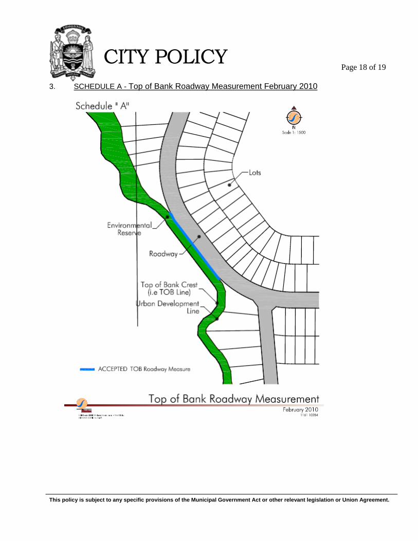
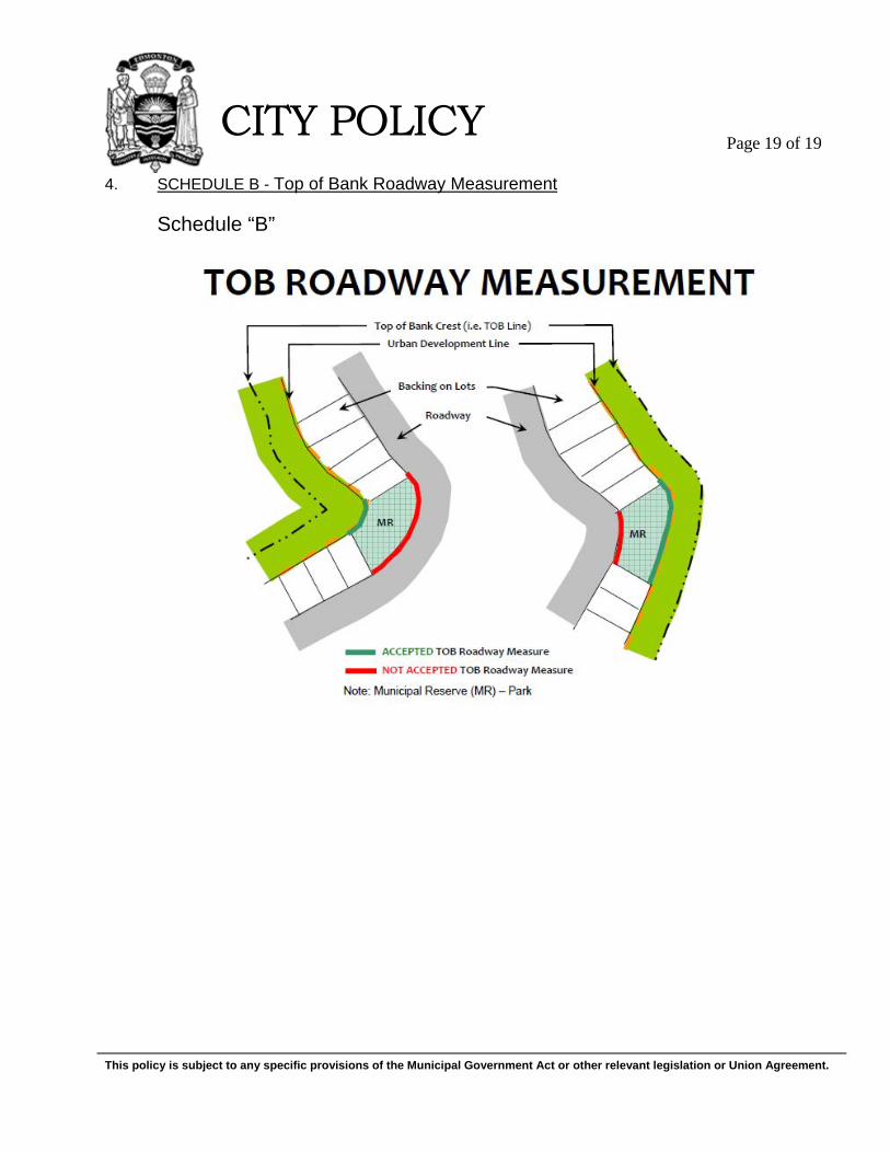
encroachment. Additional TOB Roadway may be required to achieve the aforementioned factors based on final technical and planning assessments and recommendations. In particular, additional TOB Roadway or alternatively, additional setbacks shall be incorporated in those areas, identified by Administration, with significant Vistas or Views to facilitate the provision of public promenade amenities and access. Findings and recommendations from both technical studies and assessments will be used to inform TOB Roadway design at the neighbourhood level. The TOB roadway requirement shall be measured as a percentage of the entire length of the Urban Development Line. The TOB Roadway shall be generally coterminous with the urban Development Line and shall be measured as set out in Schedule A. Where additional land is taken beyond the Urban Development Line for municipal purposes fronting on a top of bank roadway (e.g. park), the calculation shall include the length of the Urban Development Line used for that purpose and shall be measured as set out in Schedule B.
Ensure preservation of the River Valley and Ravine System as a significant visual and natural amenity feature, contributor to the ecological functionality of the City's natural areas system, and recreational opportunity for the citizens of Edmonton. 1.09 Coordination of relevant City policies and plans such as the Natural Area
Systems Policy C531, Urban Parks Management Plan, Ribbon of Green, the North Saskatchewan River Valley Area Redevelopment Plan, and A Plan of Action for the Capital Region River Valley Park with top of bank development shall begin at the area structure plan level to ensure strong planning integration below and above the top of bank. Much of the technical assessment will be done at the neighbourhood planning level.
This policy is subject to any specific provisions of the Municipal Government Act or other relevant legislation or Union Agreement.
CITY POLICY Page 6 of 19
1.10 A number of measures shall be undertaken to enhance the visual appreciation and experience associated with the River Valley and Ravine System. Identification of Vistas and Views along with a strong Visual Connection (e.g. View Corridor) to the River Valley and Ravine System shall begin at the area structure plan level to ensure a high quality of public access. Much of the technical assessments will be done at the neighbourhood planning level.
1.11 Ecological Network function, design, and mechanisms for acquiring lands
within the Upland Area for conservation shall be identified through Ecological Design Report in the preparation of future statutory and non-statutory land use plans.
1.12 This policy and the North Saskatchewan River Valley Area Redevelopment Plan
work together to ensure that appropriate boundaries on the slopes and top of bank or Upland Area are identified to preserve the River Valley and Ravine System.
1.13 The City will work with property owners and developers of lands adjacent to
and/or wholly or partially within the North Saskatchewan River Valley and Ravine System to acquire lands necessary to achieve relevant municipal planning objectives. Where possible, the City will encourage and promote the donation of all or a portion of these lands through innovative measures such as, but not necessarily limited to, income tax receipts (i.e. split receipting) for eco-gifts, environmental reserve easements, transfer of development rights, eco-trusts and non-credit municipal reserve dedication.
This policy is subject to any specific provisions of the Municipal Government Act or other relevant legislation or Union Agreement.
CITY POLICY
Page 7 of 19
Abutting
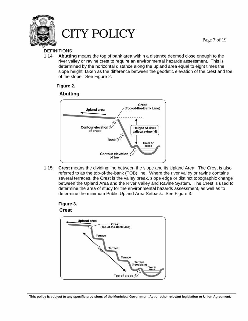
Crest
DEFINITIONS 1.14 Abutting means the top of bank area within a distance deemed close enough to the
river valley or ravine crest to require an environmental hazards assessment. This is determined by the horizontal distance along the upland area equal to eight times the slope height, taken as the difference between the geodetic elevation of the crest and toe of the slope. See Figure 2.
Figure 2.
1.15 Crest means the dividing line between the slope and its Upland Area. The Crest is also referred to as the top-of-the-bank (TOB) line. Where the river valley or ravine contains several terraces, the Crest is the valley break, slope edge or distinct topographic change between the Upland Area and the River Valley and Ravine System. The Crest is used to determine the area of study for the environmental hazards assessment, as well as to determine the minimum Public Upland Area Setback. See Figure 3. Figure 3.
This policy is subject to any specific provisions of the Municipal Government Act or other relevant legislation or Union Agreement.
CITY POLICY
Page 8 of 19
1.16 Crime Prevention Through Environmental Design (CPTED) means the design and effective use of the built environment to reduce fear and incidence of crime while improving overall quality of life.
1.17 Ecological Network means a coherent system of natural and/or semi-natural landscape
elements that is configured and managed with the objective of maintaining or restoring ecological functions as a means to conserve biodiversity. Edmonton’s Ecological Network structure includes:
(a) Regional Biodiversity Corridor – The North Saskatchewan River Valley is the
most critical component for wildlife movement and ecological processes in Edmonton;
(b) Biodiversity Core Areas – Natural areas large enough to support entire populations of different species and may also serve as an important linkage;
(c) Linkages – Non-linear stepping-stones and linear ecological corridors provide structural and or functional connections between biodiversity core areas and the regional biodiversity corridor. These may take the form of either natural linkages (i.e. sites dominated by naturally occurring patterns of native vegetation such as natural areas, naturalized parks or stormwater facilities) or semi-natural linkages (e.g. sites with more manicured green space such as active recreation parks, cemeteries, schoolyards, non-naturalized stormwater facilities or public rights of ways); and
(d) Matrix – Background ecosystems or land uses within which habitat patches (core areas and linkages) lie on a landscape (e.g. sites found within agricultural, residential, commercial and or industrial lands that contribute to the overall habitat and or level of connectivity within the Ecological Network.
1.18 Environmental Reserve means land (as per Section 664(1) of the Municipal Government Act) that consists of:
(a) Swamp, gully, ravine, coulee or natural drainage course; (b) Land that is subject to flooding or is, in the opinion of the subdivision authority,
unstable; or (c) A strip of land, not less than six metres in width, abutting the bed and shore of
any lake, river, stream, or other body of water for the purpose of: (i) Preventing pollution, or (ii) Providing public access to and beside the bed and shore.
Section 671(1) of the MGA states that Environmental Reserve must be left in its natural state or be used as a public park. Under Section 676 of the MGA, a council may, by bylaw, after giving notice in accordance with Section 606 and holding a public hearing in accordance with Section 230, use an Environmental Reserve for a purpose not specified in Section 671(1). Notwithstanding Section 671, roads, public utilities, and oil and gas pipelines or transmission lines may be placed on reserve land.
This policy is subject to any specific provisions of the Municipal Government Act or other relevant legislation or Union Agreement.
CITY POLICY
Page 9 of 19
Estimated Long Term Line of Stability/Urban Development Line
Environmental Reserve, as illustrated in Figures 1, 4, 5, 6, 7 and 8 is further explained by this Policy and demarcated generally by the Urban Development Line, to include: (a) The upland area that is unstable and non-developable due to slope instability or
other physical conditions as identified in the geotechnical assessment report and characterized by the Estimated Long Term Line of Stability;
(b) The Upland Area that is non-developable due to other environmental hazards such as flooding and subsidence or ground collapse due to mines, excavations or sinkholes;
(c) Any other land contemplated as Environmental Reserve under the Municipal Government Act, whichever is the greater.
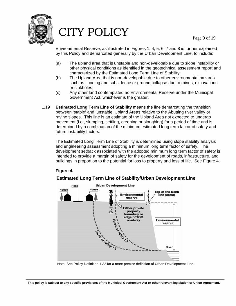
1.19 Estimated Long Term Line of Stability means the line demarcating the transition
between ‘stable’ and ‘unstable’ Upland Areas relative to the Abutting river valley or ravine slopes. This line is an estimate of the Upland Area not expected to undergo movement (i.e., slumping, settling, creeping or sloughing) for a period of time and is determined by a combination of the minimum estimated long term factor of safety and future instability factors.
The Estimated Long Term Line of Stability is determined using slope stability analysis and engineering assessment adopting a minimum long term factor of safety. The development setback associated with the adopted minimum long term factor of safety is intended to provide a margin of safety for the development of roads, infrastructure, and buildings in proportion to the potential for loss to property and loss of life. See Figure 4.
Figure 4.
Note: See Policy Definition 1.32 for a more precise definition of Urban Development Line.
This policy is subject to any specific provisions of the Municipal Government Act or other relevant legislation or Union Agreement.
CITY POLICY
Page 10 of 19
The analysis and assessment of the Estimated Long Term Line of Stability also allows for future instability factors. Future instability factors include such considerations as: the estimated toe erosion over a period of 150 years; the anticipated increase in groundwater levels in a developed urban drainage basin; any anticipated or planned removal of vegetation; any planned placement of fill, re-grading, or related changes in surface water regime; and any instability associated with other physical conditions, such as mines excavations and sinkholes, where applicable. All relevant future instability factors are to be considered over a period of at least one life cycle of development or the estimated life expectancy of the structure. In ‘fronting on’ TOB development situations, where there is a TOB Roadway, a minimum estimated long term factor of safety of 1.3, incorporating future instability factors, is used to establish the boundary of the road right-of-way abutting the non-developable Upland Area. This boundary will be deemed to be the Urban Development Line where it is greater than the setback required for other environmental hazards or the minimum Public Upland Area Setback. In ‘backing on’ TOB development situations, where there is no TOB Roadway, a minimum estimated long term factor of safety of 1.3, incorporating future instability factors, is used to establish the rear property line for development. This boundary is deemed to be the Urban Development Line where it is greater than the setback required for other environmental hazards or the minimum Public Upland Area Setback. A minimum estimated long term factor of safety of 1.5, incorporating future instability factors, is used to establish the rear foundation of any primary dwelling or structure. Based on engineering assessment consistent with the current local state of practice in geotechnical engineering, the recommended setback lines for development and structures shall be determined by the Geotechnical Engineer, and shall be in accordance with the concept of an Estimated Long Term Line of Stability. The recommended development setback lines shall also be suitably documented as part of the geotechnical report submitted for review by the City. The role of the Geotechnical Engineer through their judgment and experience in understanding the site-specific issues and geological setting, and in recognizing the complexities of geotechnical behaviour and the inherent limitations in models and theories, is of considerable importance. The management of geotechnical risk is distributed amongst the many aspects of the overall investigation, analyses and engineering assessment.
1.20 Major Slope means a slope with inclination greater than 15 degrees and height greater
than 10 metres. For non-uniform slope geometries, a Major Slope shall also be indicated by the presence of any intermediate portion of the slope, with inclination greater than 15 degrees and height greater than 10 metres, between two areas of different slope angle.
1.21 Minor Slope means a slope with inclination less than 15 degrees and height less than
10 metres.
This policy is subject to any specific provisions of the Municipal Government Act or other relevant legislation or Union Agreement.
CITY POLICY
Page 11 of 19
1.22 Moderate Slopes means slopes with inclination greater than 15 degrees but having height less than 10 metres.
1.23 Natural Areas means an area of land or water dominated by native vegetation and
relatively undisturbed by human activity. Such areas could include grasslands, forests, wetlands, peatlands or riparian areas. Areas such as groomed parks, sports fields and schoolyards are not natural areas.
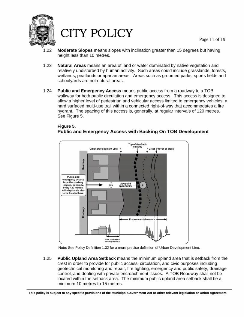
1.24 Public and Emergency Access means public access from a roadway to a TOB
walkway for both public circulation and emergency access. This access is designed to allow a higher level of pedestrian and vehicular access limited to emergency vehicles, a hard surfaced multi-use trail within a connected right-of-way that accommodates a fire hydrant. The spacing of this access is, generally, at regular intervals of 120 metres. See Figure 5. Figure 5.
Public and Emergency Access with Backing On TOB Development
1.25 Public Upland Area Setback means the minimum upland area that is setback from the crest in order to provide for public access, circulation, and civic purposes including geotechnical monitoring and repair, fire fighting, emergency and public safety, drainage control, and dealing with private encroachment issues. A TOB Roadway shall not be located within the setback area. The minimum public upland area setback shall be a minimum 10 metres to 15 metres.
Note: See Policy Definition 1.32 for a more precise definition of Urban Development Line.
This policy is subject to any specific provisions of the Municipal Government Act or other relevant legislation or Union Agreement.
CITY POLICY
Page 12 of 19
Fronting On Top-of-the-Bank (FOTOB) Development Situation
1.26 Restrictive Covenant means a legal instrument entered into by the property owner and the City which contains terms and restrictions on the use of the property which the property owner must abide by and may include the following:
(a) That the City of Edmonton is not liable for any damages resulting from bank
instability, failure or any other environmental hazards; (b) Restrictions pertaining to the required setbacks for development and structures,
site grading and fill placement, surface drainage, slope protection and the maintaining of existing vegetation;
(c) Restrictions that prohibit the construction or installation of swimming pools, ornamental ponds or similar water retention structures, as well as permanent sprinkler or irrigation systems, and other restrictions pertaining to water management and special drainage systems, and;
(d) A restriction based on the recommended guidelines for Priority Zone 1, from “FireSmart: Protecting your Community from Wildfire.”
The Restrictive Covenant will apply to property on or abutting to the Upland Area. The Restrictive Covenant is applied as a subdivision condition.
1.27 River Valley and Ravine System means the existing or former North Saskatchewan
River and its tributary creeks, including the slope or bank up to the Crest.
1.28 Toe of the Slope means the lowest point of the river valley or ravine in cross section. The Toe of the Slope shall be used in the determination of the area of study for the environmental hazards assessment. See Figure 2.
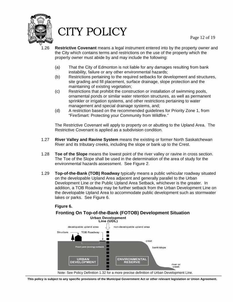
1.29 Top-of-the-Bank (TOB) Roadway typically means a public vehicular roadway situated
on the developable Upland Area adjacent and generally parallel to the Urban Development Line or the Public Upland Area Setback, whichever is the greater. In addition, a TOB Roadway may be further setback from the Urban Development Line on the developable Upland Area to accommodate public development such as stormwater lakes or parks. See Figure 6.
Figure 6.
Note: See Policy Definition 1.32 for a more precise definition of Urban Development Line.
This policy is subject to any specific provisions of the Municipal Government Act or other relevant legislation or Union Agreement.
CITY POLICY
Page 13 of 19
Backing on Top-of-the-Bank (BOTOB) Development Situation
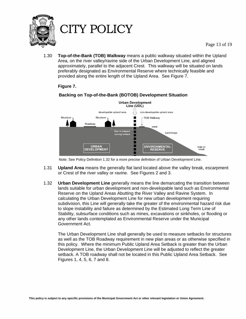
1.30 Top-of-the-Bank (TOB) Walkway means a public walkway situated within the Upland
Area, on the river valley/ravine side of the Urban Development Line, and aligned approximately, parallel to the adjacent Crest. This walkway will be situated on lands preferably designated as Environmental Reserve where technically feasible and provided along the entire length of the Upland Area. See Figure 7.
Figure 7.
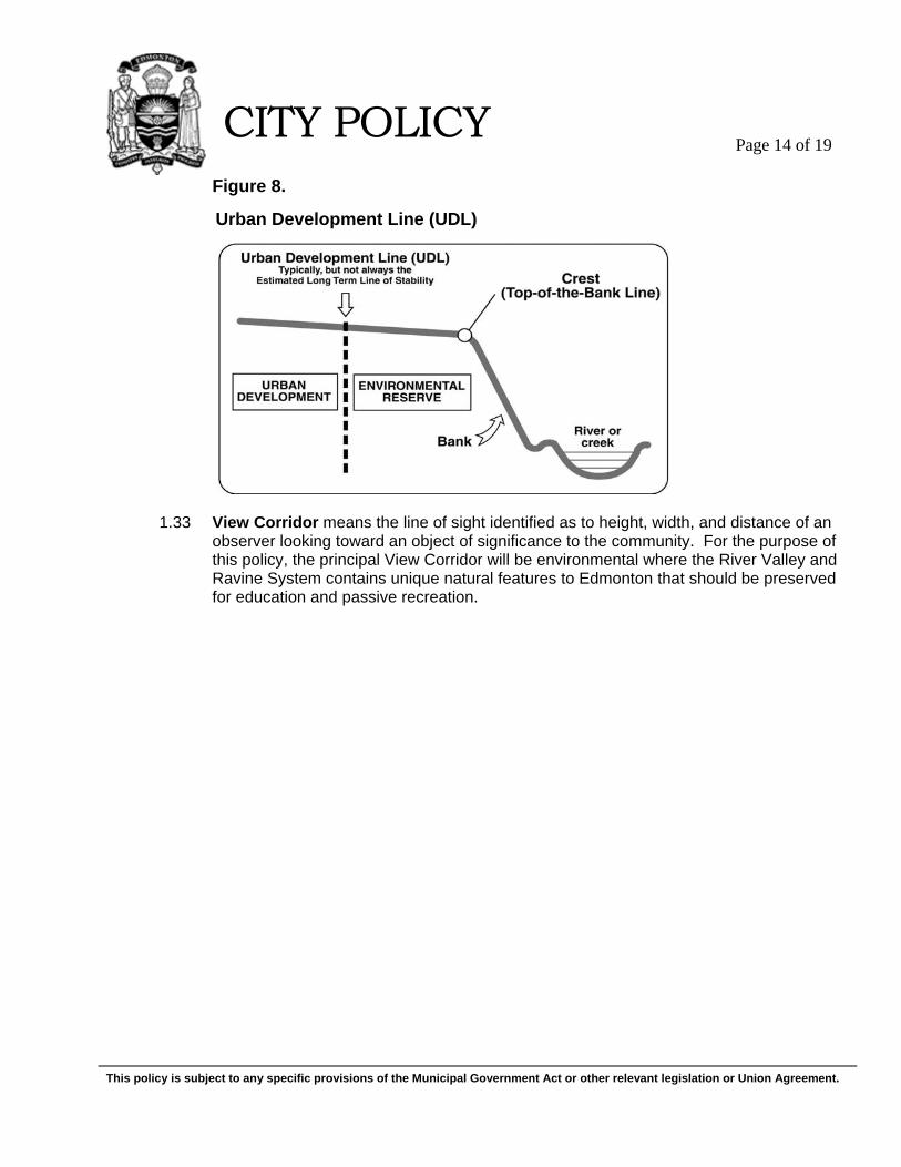
1.31 Upland Area means the generally flat land located above the valley break, escarpment or Crest of the river valley or ravine. See Figures 2 and 3.
1.32 Urban Development Line generally means the line demarcating the transition between
lands suitable for urban development and non-developable land such as Environmental Reserve on the Upland Areas Abutting the River Valley and Ravine System. In calculating the Urban Development Line for new urban development requiring subdivision, this Line will generally take the greater of the environmental hazard risk due to slope instability and failure as determined by the Estimated Long Term Line of Stability, subsurface conditions such as mines, excavations or sinkholes, or flooding or any other lands contemplated as Environmental Reserve under the Municipal Government Act.
The Urban Development Line shall generally be used to measure setbacks for structures as well as the TOB Roadway requirement in new plan areas or as otherwise specified in this policy. Where the minimum Public Upland Area Setback is greater than the Urban Development Line, the Urban Development Line will be adjusted to reflect the greater setback. A TOB roadway shall not be located in this Public Upland Area Setback. See Figures 1, 4, 5, 6, 7 and 8.
Note: See Policy Definition 1.32 for a more precise definition of Urban Development Line.
This policy is subject to any specific provisions of the Municipal Government Act or other relevant legislation or Union Agreement.
CITY POLICY
Page 14 of 19
Figure 8. 1.33 View Corridor means the line of sight identified as to height, width, and distance of an
observer looking toward an object of significance to the community. For the purpose of this policy, the principal View Corridor will be environmental where the River Valley and Ravine System contains unique natural features to Edmonton that should be preserved for education and passive recreation.
Urban Development Line (UDL)
This policy is subject to any specific provisions of the Municipal Government Act or other relevant legislation or Union Agreement.
CITY POLICY
Page 15 of 19
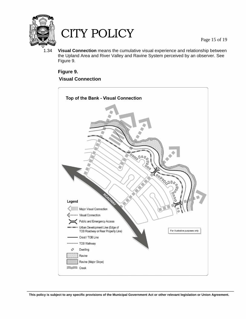
1.34 Visual Connection means the cumulative visual experience and relationship between the Upland Area and River Valley and Ravine System perceived by an observer. See Figure 9. Figure 9.
Visual Connection
This policy is subject to any specific provisions of the Municipal Government Act or other relevant legislation or Union Agreement.
CITY POLICY
Page 16 of 19
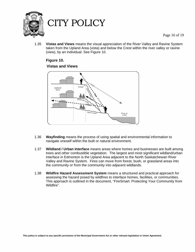
1.35 Vistas and Views means the visual appreciation of the River Valley and Ravine System
taken from the Upland Area (vista) and below the Crest within the river valley or ravine (view), by an individual. See Figure 10.
Figure 10.
1.36 Wayfinding means the process of using spatial and environmental information to navigate oneself within the built or natural environment.
1.37 Wildland / Urban Interface means areas where homes and businesses are built among
trees and other combustible vegetation. The largest and most significant wildland/urban interface in Edmonton is the Upland Area adjacent to the North Saskatchewan River Valley and Ravine System. Fires can move from forest, bush, or grassland areas into the community or from the community into adjacent wildlands.
1.38 Wildfire Hazard Assessment System means a structured and practical approach for
assessing the hazard posed by wildfires to interface homes, facilities, or communities. This approach is outlined in the document, “FireSmart: Protecting Your Community from Wildfire”.
Vistas and Views
This policy is subject to any specific provisions of the Municipal Government Act or other relevant legislation or Union Agreement.
CITY POLICY
Page 17 of 19
2. AREA OF APPLICATION This Policy applies to Upland Areas Abutting the Crest of the North Saskatchewan River Valley and Ravine System. Most though not necessarily all of the river valley and ravine system in Edmonton is located found within the boundaries of the North Saskatchewan River Valley Area Redevelopment Plan (ARP, Schedule A) Bylaw 7188 and Section 811(Appendix I) of the City’s Zoning Bylaw 12800. Notwithstanding the Area Redevelopment Plan or Zoning Bylaw boundaries, the boundary is a general boundary and is subject to more precise determination where such location is established through the approval of plans of subdivision or survey plans of the Crest. In such cases, the boundary will be amended to reflect the more precise boundary.
This policy is subject to any specific provisions of the Municipal Government Act or other relevant legislation or Union Agreement.
CITY POLICY
Page 18 of 19
3. SCHEDULE A - Top of Bank Roadway Measurement February 2010
This policy is subject to any specific provisions of the Municipal Government Act or other relevant legislation or Union Agreement.
CITY POLICY
Page 19 of 19
4. SCHEDULE B - Top of Bank Roadway Measurement
Schedule “B”