Embed Size (px)
Citation preview

Seminar 2nd December, 2015
Department of Geography, University of Cambridge
Developments toward a European Land Monitoring
Framework
Geoff Smith

Seminar 2nd December, 2015
Department of Geography, University of Cambridge
Specto Natura Limited
• Enable clients to deliver useful, accurate and reliable environmental information from EO.
• Positioned at the interface between technology development, service provision and user requirements.
• Experience in national and European R&D and operational programmes.

Seminar 2nd December, 2015
Department of Geography, University of Cambridge
Formerly known as Global Monitoring for Environment and Security (GMES)
… the European Programme for the establishment of a European capacity for Earth Observation.

Seminar 2nd December, 2015
Department of Geography, University of Cambridge
A complex landscape analysis

Seminar 2nd December, 2015
Department of Geography, University of Cambridge
Complex landscape analyses
Ducks Unlimited Canada
Mast Tree Network

Seminar 2nd December, 2015
Department of Geography, University of Cambridge
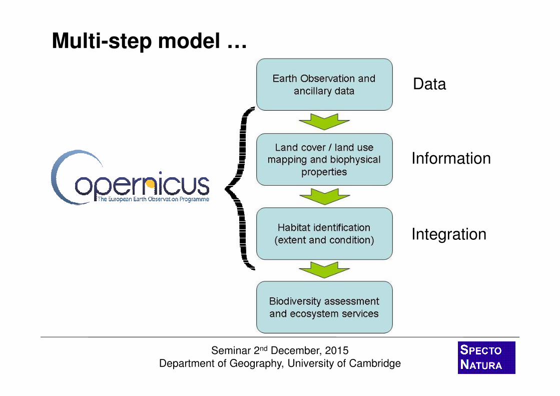
Multi-step model …
Semi-automated analysis and integration
Local knowledge on habitat definitions and pressures
Expert understanding of ecosystems and biodiversity associations
Seminar 2nd December, 2015
Department of Geography, University of Cambridge
Multi-step model …
Data
Information
Integration

Seminar 2nd December, 2015
Department of Geography, University of Cambridge
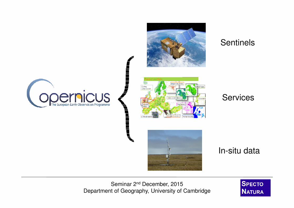
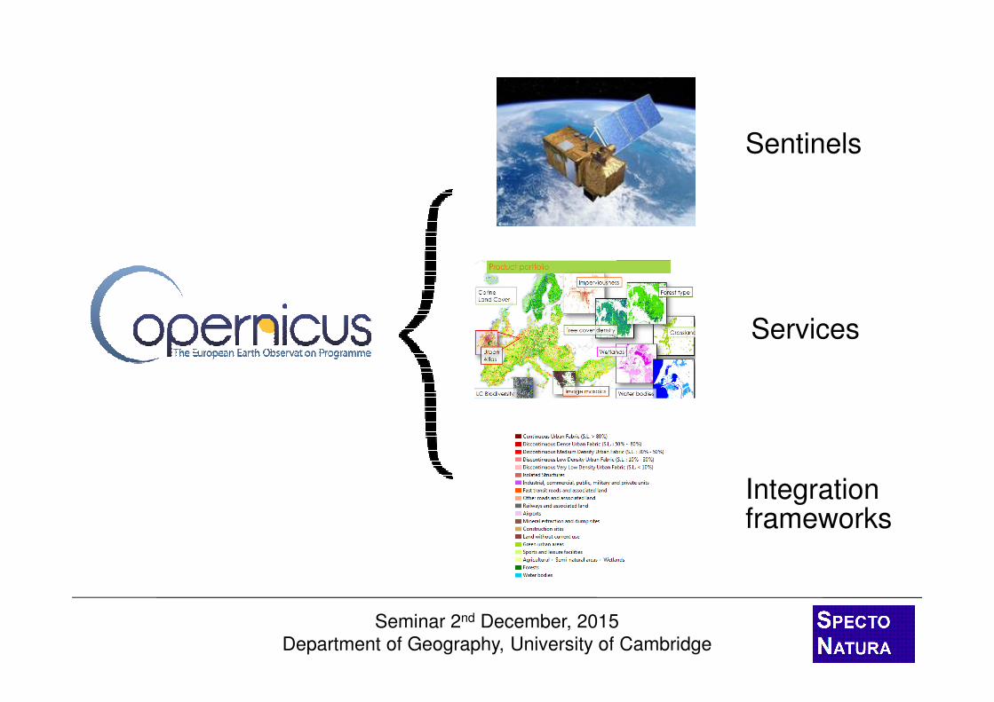
Sentinels
Services
Integration frameworks

Seminar 2nd December, 2015
Department of Geography, University of Cambridge
� Sentinels:� S1 – C-band SAR
� S2 – Super spectral HR optical
� S3 – Super spectral MR optical
� Services:� Local
� Continental / pan-European
� Global
Copernicus

Seminar 2nd December, 2015
Department of Geography, University of Cambridge
Sentinel 1 (C-band SAR, HR)
Sentinel 2 (Super-spectral optical, HR)
Sentinel 3
(Super-spectral,
optical, MR)
Images courtesy of ESA
Sentinel 4 / 5 / 6
(Meteorological / climate missions, links
to MeteoSat, MetOp, optical, LR)
The Sentinel family

Seminar 2nd December, 2015
Department of Geography, University of Cambridge
• Continuity of ERS-1, ERS-2, Envisat and Radarsat
• Synthetic Aperture Radar (SAR) mission.
• All-weather day-and-night operation.
• Two main modes: Interferometric Wide Swath and Wave.
• Swath width of 250 km
• Spatial resolution of 5×20 m.
• Revisit time of 1-3 days across Europe, Canada and shipping lanes.
• First Sentinel-1 launched in April 2014.
Sentinel-1
Seminar 2nd December, 2015
Department of Geography, University of Cambridge
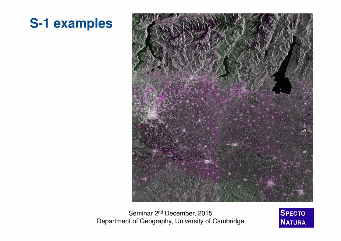
S-1 examples

Seminar 2nd December, 2015
Department of Geography, University of Cambridge
S-1 examples

Seminar 2nd December, 2015
Department of Geography, University of Cambridge
• Continuity of SPOT, IRS LISS and Landsat like data.
• Optical payload with visible, near infrared and shortwave infrared sensors.
• 13 spectral bands.– 4 bands at 10 m, 6 at 20 m and 3 at 60 m.
• Swath width of 290 km.
• With two satellites, revisit time of 5 days at the equator and 2–3 days at mid-latitudes.
• Always on over land
• The first satellite launched on 23 June.
Sentinel-2

Seminar 2nd December, 2015
Department of Geography, University of Cambridge
Sentinel 2 bands(courtesy ESA)
10 m 20 m 60 mSentinel 2simulations(Courtesy ESA)
S-2 spatial and spectral

Seminar 2nd December, 2015
Department of Geography, University of Cambridge
S-2 examples

Seminar 2nd December, 2015
Department of Geography, University of Cambridge
S-2 examples
Seminar 2nd December, 2015
Department of Geography, University of Cambridge
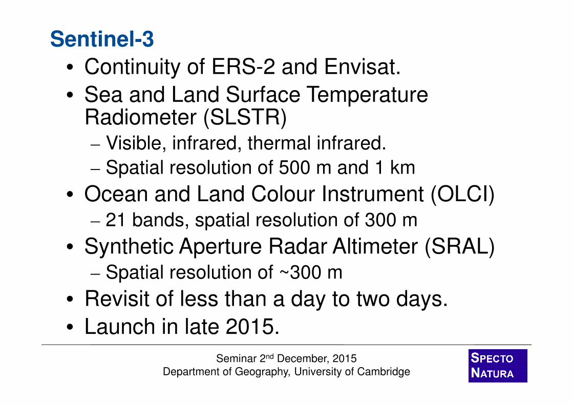
• Continuity of ERS-2 and Envisat.
• Sea and Land Surface Temperature Radiometer (SLSTR)– Visible, infrared, thermal infrared.
– Spatial resolution of 500 m and 1 km
• Ocean and Land Colour Instrument (OLCI) – 21 bands, spatial resolution of 300 m
• Synthetic Aperture Radar Altimeter (SRAL) – Spatial resolution of ~300 m
• Revisit of less than a day to two days.
• Launch in late 2015.
Sentinel-3
Seminar 2nd December, 2015
Department of Geography, University of Cambridge
Sentinels
Services
In-situ data

Seminar 2nd December, 2015
Department of Geography, University of Cambridge
WaterPermanent and transient areas
ImperviousnessSealing density
ForestCrown cover densityForest types
GrasslandGrass surface indicator
WetlandWetland indicator
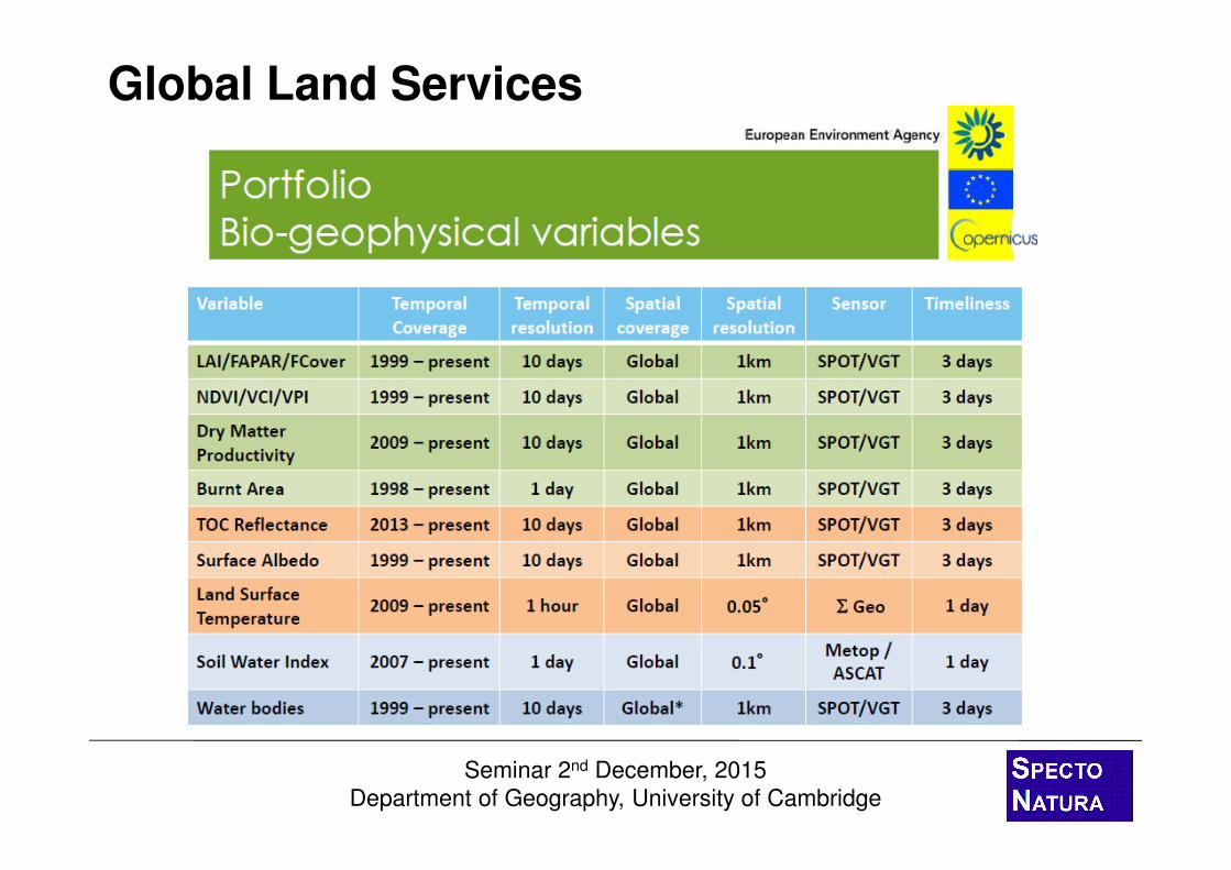
Continental: High Resolution Layers / CLC
Corine Land CoverLand cover / use mapping

Seminar 2nd December, 2015
Department of Geography, University of Cambridge
Land Services: Pan-European Component
• CORINE Land Cover (CLC)– Land cover land use mapping
– 25 ha (5 ha) MMU
– 6 year update cycle
– Member State produced
• Limitations– MMU too coarse
– Changes happen quickly
– Changes are smaller
– Biophysical info needed

Seminar 2nd December, 2015
Department of Geography, University of Cambridge
� Specifications:� Raster format.
� Intermediate products 20 m spatial resolution.
� Final products at 100 m spatial resolution.
� Continuous variables and masks.
� 3 year update cycle.
� Layers:� Imperviousness.� Forest (tree cover density & type).� Permanent grassland.� Wetland.� Permanent water bodies.
Land Services: HRLs

Seminar 2nd December, 2015
Department of Geography, University of Cambridge
Imperviousness (IMD)

Seminar 2nd December, 2015
Department of Geography, University of Cambridge
Forest tree cover density (TCD) & type (FTY)

Seminar 2nd December, 2015
Department of Geography, University of Cambridge
Permanent Grasslands (GRA)

Seminar 2nd December, 2015
Department of Geography, University of Cambridge
Wetlands (WET)

Seminar 2nd December, 2015
Department of Geography, University of Cambridge
Permanent Water Bodies (PWB)

Seminar 2nd December, 2015
Department of Geography, University of Cambridge
HRLs summary….
• Full pan-European validation is underway.
• Grassland and wetland layers being re-defined.
• Organisation of production is also like to change.
• A new way of thinking about EO-based land surface products at sub-global level.
• Not an end product in themselves.
• Consider them as support layers.
• European focus, but applicable at MS and below.
• A lot has been learnt from the GIO exercise.
• Future iterations will include Sentinel data.

Seminar 2nd December, 2015
Department of Geography, University of Cambridge
Local: Urban Atlas (Edinburgh)

Seminar 2nd December, 2015
Department of Geography, University of Cambridge
Local: Urban Atlas

Seminar 2nd December, 2015
Department of Geography, University of Cambridge
Local: Urban Atlas - Change
2006 2012
Seminar 2nd December, 2015
Department of Geography, University of Cambridge
Global Land Services

Seminar 2nd December, 2015
Department of Geography, University of Cambridge
Global: Leaf Area Index (LAI)

Seminar 2nd December, 2015
Department of Geography, University of Cambridge
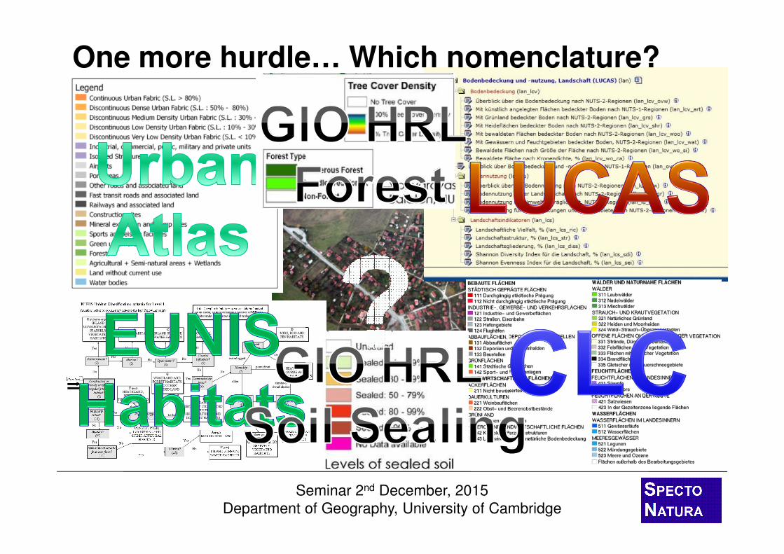
• EAGLE = EIONET Action Group on Land monitoring in Europe
• LC/LU experts from: - National land monitoring initiatives- National Reference Centers (NRC) Land Cover- INSPIRE Technical Working Groups (TWG)- ETC SIA (now ULS) partners - FP7 HELM consortium- Consultations with CLC Technical Team
• Founded through self-initiative of experts from various European countries (DE, HU, RO, CZ, NL, UK, CH, NO, FI, PT, AT, ES, CT)
• Open and voluntary participation
The EAGLE concept
Seminar 2nd December, 2015
Department of Geography, University of Cambridge
One more hurdle… Which nomenclature?

Seminar 2nd December, 2015
Department of Geography, University of Cambridge
• Fragmented user community at many levels.
• Multitude of applications working with land information.
• Many classification systems and nomenclatures.
• Mixture of land cover and land use information.
• Growing need for better integration and harmonization of land monitoring initiatives.
• Bottom-up integration (regional to national) approaches.
• Relevance for all land monitoring activities.
Main land issues …

Seminar 2nd December, 2015
Department of Geography, University of Cambridge
Grassland
Classifications• Grassland ≠ pasture
≠ lawn≠ natural grassland
Characterization• Growth structure
• homogenous
• heterogenous
• Growth density• closed
• sparse
• Moisture • wet soil
• surface water
• Use • intensive
• extensive
• sports
• Management• multiple mowing
• single mowing
• Ecosystem type• inland marsh
Starting point… characterise or classify?

Seminar 2nd December, 2015
Department of Geography, University of Cambridge
Rather than develop a fix nomenclature, information on
landscape is compiled and described within three
separate main general categories …
A.) LAND COVER Components – LCC
Abiotic, Vegetation, Water Surfaces
B.) LAND USE Attributes – LUA
Agriculture, Forestry, Industry, Transportation etc.
C.) further CHARACTERISTICS – CH
Spatial pattern, bio-physical parameters, ecosystem
types, land management practices, etc.
The EAGLE approach

Seminar 2nd December, 2015
Department of Geography, University of Cambridge
Land cover components (LCC):• Conventional buildings,
• Broadleaved trees,
• Herbaceous plants,
• Open sealed surfaces
Land use attributes (LUA):• Permanent residential,
• Agriculture / production for own consumption,
• Road network
Further characteristics (CH): • Soil sealing degree = 35%
• Built-up pattern = discontinuous, single houses
© Gyorgy Büttner
Uses: Describing landscape: Village (Built-up)

Seminar 2nd December, 2015
Department of Geography, University of Cambridge
Examples of two CORINE class definitions
LEVEL 31.1.1. Continuous urban fabric:
Most of the land is covered by structures and transport network.
Buildings, roads and artificially surface areas cover more than
80% of the total surface. Non-linear areas of vegetation and bare
soil are exceptional
1.1.2 Discontinuous urban fabric
Most of the land is covered by structures. Buildings, roads and
artificially surface areas are associated with vegetated areas and
bare soil, which occupy discontinuous but significant surfaces.
Between 10% and 80% of the land is covered by residential
structures.
Intensities
LC
Thresholds
© SIOSE, A. Arozarena
LU
CH
Uses: Decomposing class definitions
Seminar 2nd December, 2015
Department of Geography, University of Cambridge
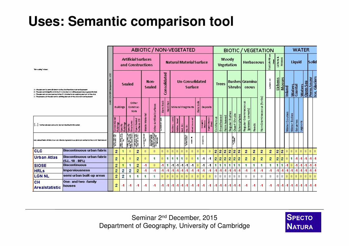
Uses: Semantic comparison tool
Seminar 2nd December, 2015
Department of Geography, University of Cambridge
Sentinels
Services
Integration frameworks

Seminar 2nd December, 2015
Department of Geography, University of Cambridge
Take home messages….
• Copernicus Sentinel data– Step change in observing capacity.
– Sentinel 1A SAR data has been operational for over a year.
– Sentinel 2A optical data is about to become operational.
– Sentinel 3A ready for launch, B units phased in over next years.
– All data available via free and open access at the Sentinels Scientific Data Hub.
– UK Collaborate Ground Segment and STFC-CEDA

Seminar 2nd December, 2015
Department of Geography, University of Cambridge
Take home messages….
• Copernicus Land Services: HRLs– European focus, but applicable at MS level and
below.
– Consider them as support layers.
– Quality is variable between layers and to a lesser extent spatially.
– Opportunities to refine and enhance layers if sufficient user feedback.
– 2012 HRLs will be launched now….?
– 2015 tendering process starting on Friday

Seminar 2nd December, 2015
Department of Geography, University of Cambridge
Take home messages….
• EAGLE concept– Data model available that can be used as a basis
for land monitoring.
– On-line comparison tool used to study and compare nomenclatures.
– Geometric testing supporting CLC2018.
– Integration within Copernicus, revised HRL specs.
– A number of projects adopting / adapting the approach
– The continuation of the exploitation and evolution essential to the harmonisation of land monitoring in Europe.

Seminar 2nd December, 2015
Department of Geography, University of Cambridge
Conclusions• These are exciting times in the use of space for solving
issues at field to continental scales in general.
• Complex landscape analyses such as biodiversty mapping require multi-scale / multi-faceted inputs.
• The Copernicus programme is now beginning to deliver the required data, information and support.
• The Sentinels (1, 2 & 3) are offering the required land surface measurements.
• The Copernicus Land Service is providing a number of suitable support products.
• There is now a major opportunity for end users and downstream service developers to implement innovative solutions which exploit these information sources to address important issues and provide economic growth.

Seminar 2nd December, 2015
Department of Geography, University of Cambridge
Any other questions?
Geoff Smith,
Specto Natura, Ltd.


![Toward Hands-Off Crowdsourcing: Crowdsourced Entity ...pages.cs.wisc.edu › ~anhai › papers › corleone-tr.pdfcrowdsource joins [17], nd the maximal value [10], collect data [25],](https://img.pdfslide.net/doc/110x75/5f109e0e7e708231d449fd03/toward-hands-off-crowdsourcing-crowdsourced-entity-pagescswiscedu-a-anhai.jpg)