Embed Size (px)
Citation preview

Di1a: 1UFFICIO GENERALE PER LA METEOROLOGIA
Short term plans of activities Short term plans of activities related to NWP at UGMrelated to NWP at UGM
Zurich 20-23 Sept. 2005 Massimo Ferri
SummarySummaryComputer resources
Collaborations
HSAF
Dia: 2UFFICIO GENERALE PER LA METEOROLOGIA

Computer resources
To mantain a time critical application at ECMWF based on 3d-Var PSAS D.A., HRM as regional model and Lokal Model as high resolution model (B.C. from IFS)
To implement a Linux cluster facility for NWP application ( current state: benchmarking of LM )
Dia: 3UFFICIO GENERALE PER LA METEOROLOGIA
Collaborations Brasilian Institutes (INMET and Navy) cooperate
with CNMCA in the devolepment of the 3d-var PSAS D.A.
Israeli-Italian cooperation on Modeling System for Urban Air Pollution
Cooperation with PNRA in the development of a forecast system for the antarctica region (research activity in the framework of IPY)
Dia: 4UFFICIO GENERALE PER LA METEOROLOGIA

HSAFThe New H-SAF for HydrologyIn recent years, the interest of the hydrological community for using satellite data has rapidly increased because of improvements of satellite data quality and of performance of hydrological models including their capability to assimilate observational data.H-SAF BackgroundEumetsat started to study how to give operational support to the hydrological community. A consultation among EUMETSAT Member and Cooperating States showed that the best solution to achieve such a support was to establish a new SAF.

HSAF
H-SAF ObjectivesHSAF has to provide new satellite-derived products: precipitation (liquid, solid, rate, cumulate) soil moisture (at surface, in the roots region) snow parameters (cover, melting conditions,
water equivalent); to perform independent validation of the
usefulness of the new products for hydrological applications.

H-SAF ConsortiumItaly (Aeronautica Militare - Ufficio Generale per la Meteorologia) has been selected to lead the HSAF Consortium of the following Eumetsat members and cooperating states.
No Country Main Unit in the Country Role
01 Austria ZAMG Leader for soil moisture
02 Belgium RMI
03 NA ECMWF Contributor for “core” soil moisture
04 Finland FMI Leader for snow parameter
05 France MF
06 Germany Bundesanstalt für
Gewässerkunde 07 Hungary HMS
08 Italy UGM Host+Leader for precipitation
09 Poland IMGW Leader for hydrological validation
10 Romania NIMH
11 Slovakia SHMI
12 Turkey Turkish State Meteorological Service
Contributor for “core” snow param.

HSAFH-SAF Precipitation Products
Italy with other countries will produce, in real time, precipitation observation maps over Europe with a resolution of 10km and best accuracy of 10%. The rain rate directly retrieved from Polar orbiting satellite data will be combined with the Geostationary satellite Data ( Meteosat Second Generation). Below an example of rain rate retrieval from polar orbiting satellite.
HSAF
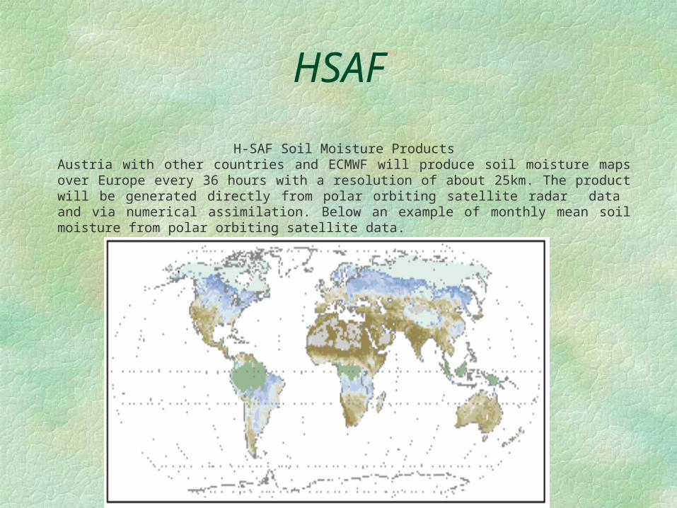
H-SAF Soil Moisture ProductsAustria with other countries and ECMWF will produce soil moisture maps over Europe every 36 hours with a resolution of about 25km. The product will be generated directly from polar orbiting satellite radar data and via numerical assimilation. Below an example of monthly mean soil moisture from polar orbiting satellite data.

HSAF
H-SAF Snow ProductsFinland with other Countries will produce snow maps over Europe with a resolution of 2 – 10 km, giving information on snow coverage, depth, status and water equivalent content. Below an example of snow
depth retrieval form polar orbiting satellite data merged with in situ observations.

HSAF
H-SAF Validation Studies
Countries responsible for impact studies and validation will test the HSAF products versus Hydrological
models over specific basins as in the map below.

HSAF
H-SAF System Architecture
HSAF system architecture takes advantage of input data form both Polar orbiting and geostationary satellites
Soil moistureat surface
layerAUSTRIA
Soil moisturein roots region
ECMWF
Snow parametersin flat land,
forestsFINLAND
Snow parametersin mountain
areasTURKEY
Precipitation products observed
and forecastITALY
CoordinationITALY as
Host
PROCESSING
CENTRES
Various links
Dedicated links
H-SAFArchive
U-MARF
Institutes incharge of
hydrological
validation(led by
POLAND)
Other R&D Institutes
SCIENTIFIC
USERS
U-MARF Client
Satellites bydirect read-out
Localdatabases
Products fromother SAF’s
Ancillary datalocally available
NWP productsand climatology
Satellites viaEUMETCast
INPUTDATA

HSAFH-SAF Product Distribution Scheme
HSAF products will be disseminated world wide in pictorial and numerical format via Eumetcast (Eumetsat satellite broadcast service) and via international meteorological networks as standard World Weather Organisation messages.
Domestic dissemination will be responsibility of participating Countries.


![Corso basico di meteorologia[€Home€] [€Novità€] [€Cosa€bolle€in€pentola€] [€Climatologia€] [€Corso€basico€di€meteorologia€] [€Meteorologia€aeronautica€]](https://img.pdfslide.net/doc/110x75/5e7d9554f30b791b3934d686/corso-basico-di-meteorologia-ahomea-anovita-acosaabolleainapentolaa.jpg)