Embed Size (px)
Citation preview

Bath and North East Somerset
Annex to Schedule of Inspector’s Recommended Main Modifications to the Submitted Core Strategy
Diagrams and Maps
June 2014

Index
Main Modifications - Diagrams and Maps (updated May 2014)
Main Modifications to the Core Strategy Diagrams
Diagram Change Ref
Proposed Change Annex Page
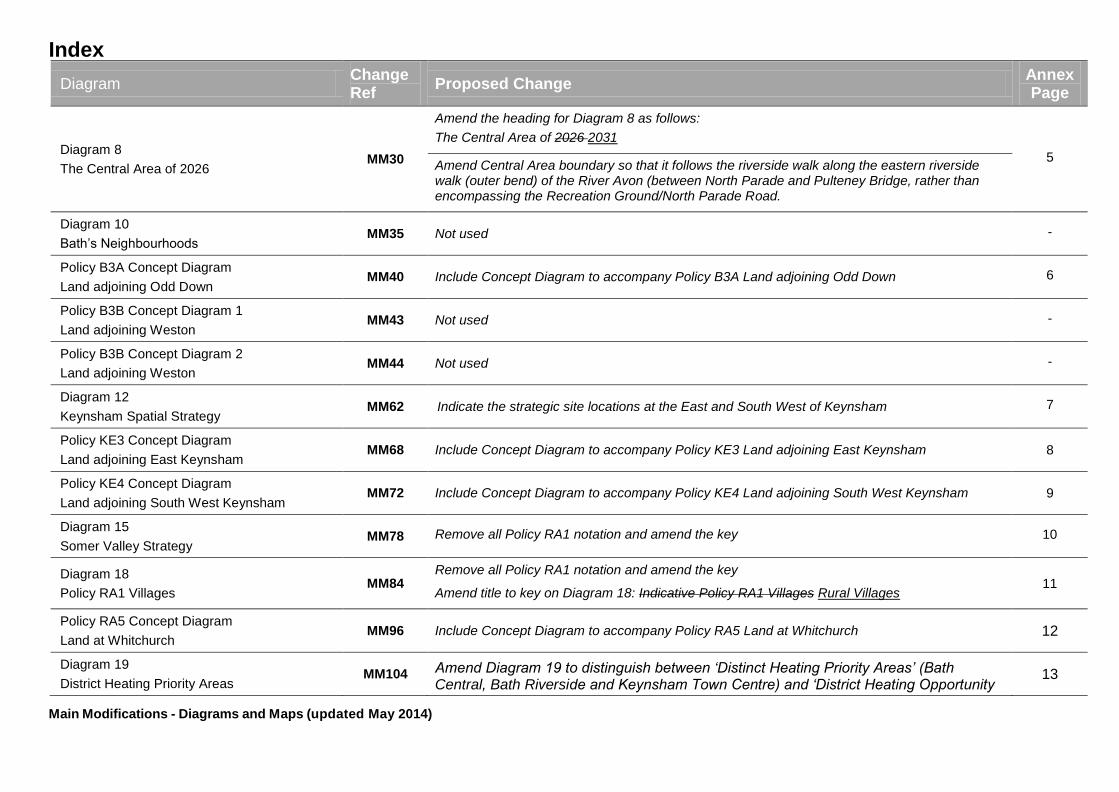
Diagram 4
(Key Diagram) MM19
Remove all Policy RA1 notation and amend the key
1
Amend the housing and employment figures for Bath, Keynsham, the Somer Valley and the Rural Areas
Amend urban area of Bath/Green Belt in the vicinity of Odd Down so that it more accurately illustrates the general extent of the Green Belt (to show the park & ride site and adjoining land within the Green Belt)
Show the general extent of the Green Belt as proposed to be amended and indicate the strategic site locations at Bath, Keynsham and Whitchurch
Update to only include the three “District Heating Priority Areas” – Bath Central, Bath Riverside and Keynsham Town Centre
Diagram 5
Bath Spatial Strategy
MM22
Indicate the strategic site location at Odd Down, Bath.
2
Bath‟s Neighbourhoods label to be amended to reflect revised policy wording.
Amend the area of search for location of flood storage facility to extend westwards following the line of the river.
Amend Central Area boundary so that it follows the riverside walk along the eastern riverside walk (outer bend) of the River Avon (between North Parade and Pulteney Bridge, rather than encompassing the Recreation Ground/North Parade Road.
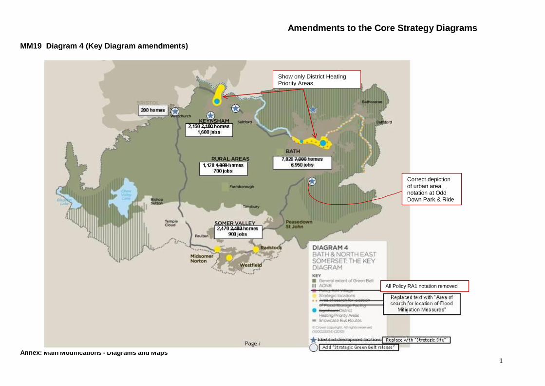
Diagram 6
The Central Area and Western Corridor MM25
Amend Central Area boundary so that it follows the riverside walk along the eastern riverside walk (outer bend) of the River Avon (between North Parade and Pulteney Bridge, rather than encompassing the Recreation Ground/North Parade Road.
3
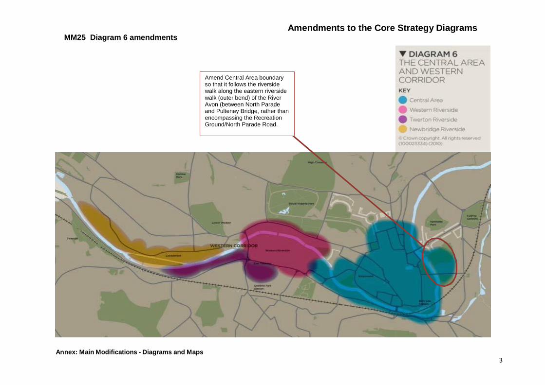
Diagram 7
General Extent of the Central Area MM27
Amend notation Central Area – City Centre (indicative boundary only - detailed boundary is shown on the Proposals Map
4 Amend Central Area boundary so that it follows the riverside walk along the eastern riverside walk (outer bend) of the River Avon (between North Parade and Pulteney Bridge, rather than encompassing the Recreation Ground/North Parade Road.
Index
Main Modifications - Diagrams and Maps (updated May 2014)
Diagram Change Ref
Proposed Change Annex Page
Diagram 8
The Central Area of 2026 MM30
Amend the heading for Diagram 8 as follows:
The Central Area of 2026 2031
5 Amend Central Area boundary so that it follows the riverside walk along the eastern riverside walk (outer bend) of the River Avon (between North Parade and Pulteney Bridge, rather than encompassing the Recreation Ground/North Parade Road.
Diagram 10
Bath’s Neighbourhoods MM35 Not used -
Policy B3A Concept Diagram
Land adjoining Odd Down MM40 Include Concept Diagram to accompany Policy B3A Land adjoining Odd Down 6
Policy B3B Concept Diagram 1
Land adjoining Weston MM43 Not used -
Policy B3B Concept Diagram 2
Land adjoining Weston MM44 Not used -
Diagram 12
Keynsham Spatial Strategy MM62 Indicate the strategic site locations at the East and South West of Keynsham 7
Policy KE3 Concept Diagram
Land adjoining East Keynsham MM68 Include Concept Diagram to accompany Policy KE3 Land adjoining East Keynsham 8
Policy KE4 Concept Diagram
Land adjoining South West Keynsham MM72 Include Concept Diagram to accompany Policy KE4 Land adjoining South West Keynsham 9
Diagram 15
Somer Valley Strategy MM78 Remove all Policy RA1 notation and amend the key 10
Diagram 18
Policy RA1 Villages MM84
Remove all Policy RA1 notation and amend the key
Amend title to key on Diagram 18: Indicative Policy RA1 Villages Rural Villages 11
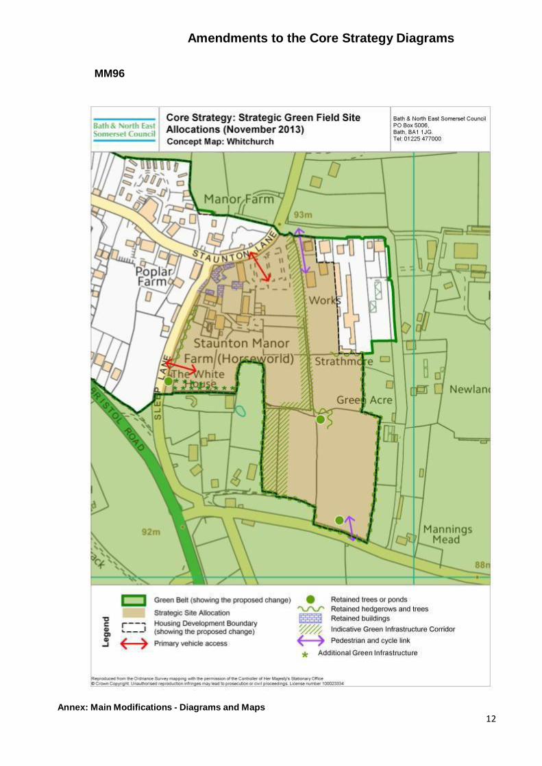
Policy RA5 Concept Diagram
Land at Whitchurch MM96 Include Concept Diagram to accompany Policy RA5 Land at Whitchurch 12
Diagram 19
District Heating Priority Areas MM104 Amend Diagram 19 to distinguish between „Distinct Heating Priority Areas‟ (Bath
Central, Bath Riverside and Keynsham Town Centre) and „District Heating Opportunity 13

Index
Main Modifications - Diagrams and Maps (updated May 2014)
Diagram Change Ref
Proposed Change Annex Page
Areas‟ and amend Key accordingly.
Diagram 20a
General extent of the surface coal Mineral Safeguarding Area
MM116 Include new Diagram 20a showing general extent of the surface coal Mineral Safeguarding Area. 14
Diagram 20b
Geographic two-way split for affordable housing (indicative)
MM125 Include new Diagram 20b to show the geographic two-way split for affordable housing 15
Main Modifications to the Policies Map
Change Ref Proposed Change Annex Page
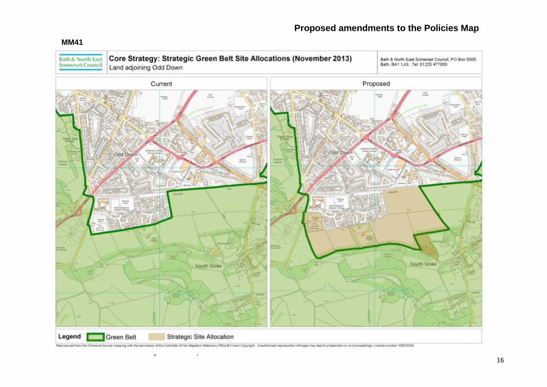
MM41 Show the boundary of the strategic site allocation for Land adjoining Odd Down, Bath and the revised Green Belt boundary. 16
MM45 Not used -
MM69 Show the boundary of the strategic site allocation for Land adjoining East Keynsham and the revised Green Belt boundary. 17
MM70 Not used -
MM73 Show the boundary of the strategic site allocation for Land adjoining South West Keynsham and the revised Green Belt boundary 18
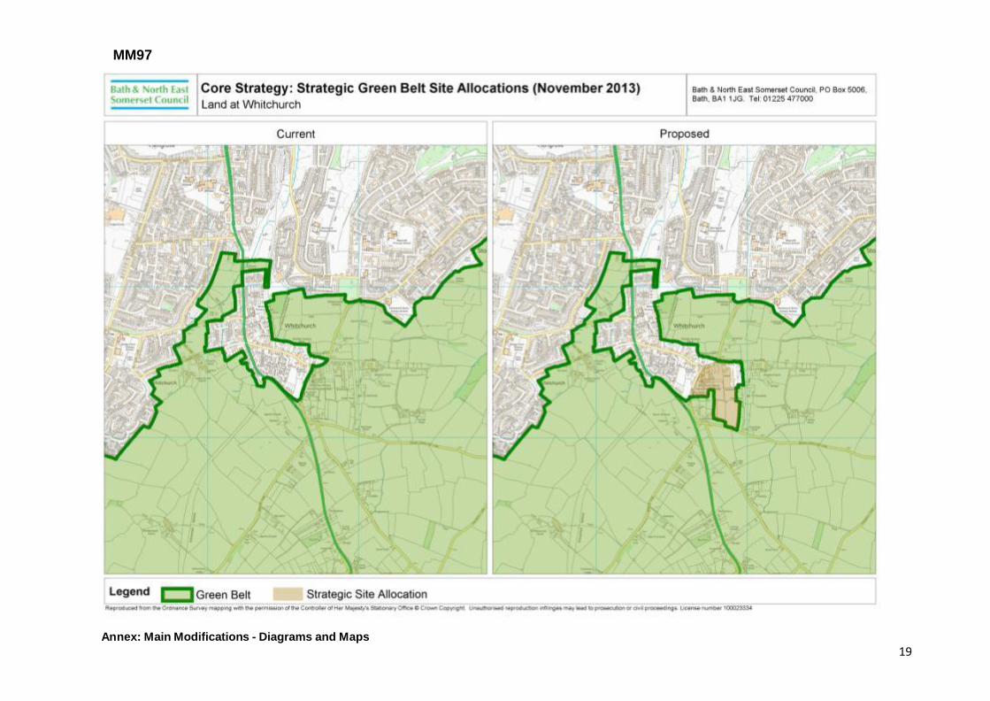
MM97 Show the boundary of the strategic site allocation for Land at Whitchurch and the revised Green Belt boundary 19
Amendments to the Core Strategy Diagrams
Annex: Main Modifications - Diagrams and Maps 1
MM19 Diagram 4 (Key Diagram amendments)
Correct depiction of urban area notation at Odd Down Park & Ride
All Policy RA1 notation removed
Show only District Heating Priority Areas

Amendments to the Core Strategy Diagrams
Annex: Main Modifications - Diagrams and Maps 2
MM22 Diagram 5 amendments
Amend Central Area boundary so that it follows the riverside walk along the eastern riverside walk (outer bend) of the River Avon (between North Parade and Pulteney Bridge, rather than encompassing the Recreation Ground/North Parade Road.
Extend the area of search
for the location of for flood
mitigation measures
Rename ‘Area of search
for location of Flood
Mitigation Measures’
Bath’s Neighbourhoods label to be amended to reflect revised policy wording
Strategic Site Strategic Green Belt release
Amendments to the Core Strategy Diagrams
Annex: Main Modifications - Diagrams and Maps 3
MM25 Diagram 6 amendments
Amend Central Area boundary so that it follows the riverside walk along the eastern riverside walk (outer bend) of the River Avon (between North Parade and Pulteney Bridge, rather than encompassing the Recreation Ground/North Parade Road.
Amendments to the Core Strategy Diagrams MM27 Diagram 7 amendments
Annex: Main Modifications - Diagrams and Maps 4
Amend Central Area notation: City Centre (indicative boundary only - detailed boundary is shown on the Proposals Map)
Amend Central Area boundary so that it follows the riverside walk along the eastern riverside walk (outer bend) of the River Avon (between North Parade and Pulteney Bridge, rather than encompassing the Recreation Ground/North Parade Road.

Amendments to the Core Strategy Diagrams MM30 Diagram 8 amendments
Annex: Main Modifications - Diagrams and Maps 5
Amend Central Area boundary so that it follows the riverside walk along the eastern riverside walk (outer bend) of the River Avon (between North Parade and Pulteney Bridge, rather than encompassing the Recreation Ground/North Parade Road.

Amendments to the Core Strategy Diagrams
Annex: Main Modifications - Diagrams and Maps 6
MM40

Amendments to the Core Strategy Diagrams
Annex: Main Modifications - Diagrams and Maps 7
MM62 Diagram 12 amendments
Strategic Site
Strategic Green Belt release

Annex: Main Modifications - Diagrams and Maps 8
MM68
Amendments to the Core Strategy Diagrams

Annex: Main Modifications - Diagrams and Maps 9
MM72
Amendments to the Core Strategy Diagrams

Amendments to the Core Strategy Diagrams
Annex: Main Modifications - Diagrams and Maps 10
Remove all Policy RA1 notation and
amend the key
MM78 Diagram 15 amendments

Amendments to the Core Strategy Diagrams
Annex: Main Modifications - Diagrams and Maps 11
Remove all Policy RA1 notation and
amend the key
MM84 Diagram 18 amendments
Annex: Main Modifications - Diagrams and Maps 12
Amendments to the Core Strategy Diagrams
MM96

Amendments to the Core Strategy Diagrams MM104 Diagram 19 amendments
Annex: Main Modifications - Diagrams and Maps 13
Amend Diagram 19 to distinguish between ‘Distinct Heating Priority Areas’ (Bath Central, Bath Riverside and Keynsham Town Centre) and ‘District Heating Opportunity Areas’.
District heating priority areas
District heating opportunity areas
Amend key to:

Amendments to the Core Strategy Diagrams MM116 New Diagram 20a
Annex: Main Modifications - Diagrams and Maps 14
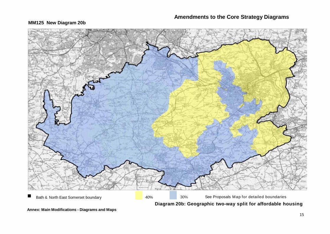
Amendments to the Core Strategy Diagrams MM125 New Diagram 20b
Annex: Main Modifications - Diagrams and Maps 15
Bath & North East Somerset boundary
40% 30% See Proposals Map for detailed boundaries
Diagram 20b: Geographic two-way split for affordable housing
Proposed amendments to the Policies Map
Annex: Main Modifications - Diagrams and Maps 16
MM41

Proposed amendments to the Policies Map
Annex: Main Modifications - Diagrams and Maps 17
Areas of safeguarded land to be shown in pink as defined on the East of Keynsham Concept Diagram (see page 12 of this Annex)
MM69
.
Proposed
"-·

Proposed amendments to the Policies Map
Annex: Main Modifications - Diagrams and Maps 18
MM73
Annex: Main Modifications - Diagrams and Maps 19
MM97


![Ajay mishra sonia cartridge calculus and arithemtic with [a] what [b] how to maps +diagrams](https://img.pdfslide.net/doc/110x75/5562c526d8b42aaf178b4e70/ajay-mishra-sonia-cartridge-calculus-and-arithemtic-with-a-what-b-how-to-maps-diagrams.jpg)