Embed Size (px)
Citation preview
Diamond Drill Report On the Eskay Project
Claims: Aftom 18, Bonsai, Bonsai 3,Harry 2,
John 2, King 3, Polo 7, Unuk 13, Unuk 14
56° 34’ 44.3” N, 130° 28’ 21.4” W
N.T.S 104B 7-10 Skeena Mining Division
For
Heritage Explorations Ltd.
1540 Cornwall Road, Suite 212
Oakville, Ontario Canada
L6J 7W5
By
Warren Ross Bates, P.Geo. St. Andrew Goldfields Limited 1540 Cornwall Road, Suite 212
Oakville, Ontario Canada
L6J 7W5
November 2005
2
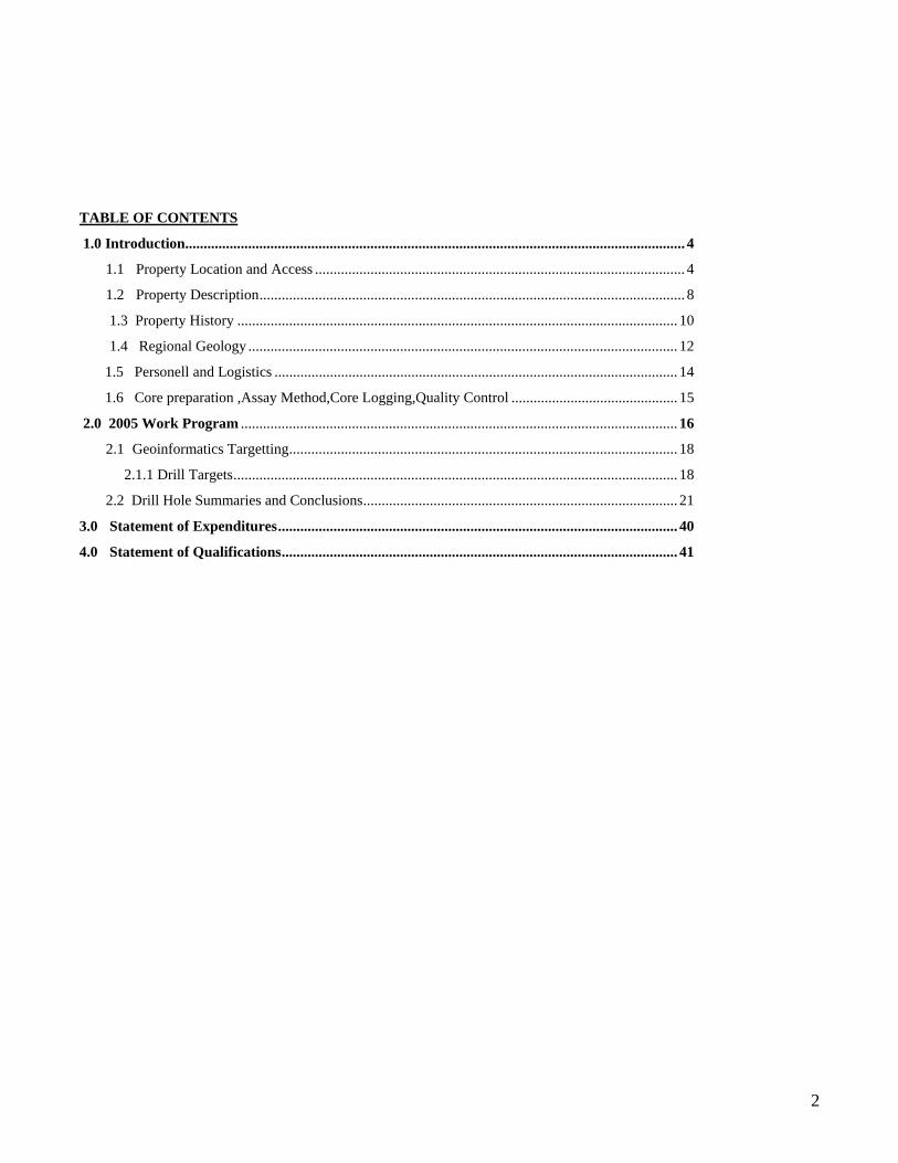
TABLE OF CONTENTS
1.0 Introduction....................................................................................................................................... 4
1.1 Property Location and Access .................................................................................................... 4
1.2 Property Description................................................................................................................... 8
1.3 Property History ....................................................................................................................... 10
1.4 Regional Geology .................................................................................................................... 12
1.5 Personell and Logistics ............................................................................................................. 14
1.6 Core preparation ,Assay Method,Core Logging,Quality Control ............................................. 15
2.0 2005 Work Program ...................................................................................................................... 16
2.1 Geoinformatics Targetting......................................................................................................... 18
2.1.1 Drill Targets........................................................................................................................ 18
2.2 Drill Hole Summaries and Conclusions..................................................................................... 21
3.0 Statement of Expenditures............................................................................................................ 40
4.0 Statement of Qualifications........................................................................................................... 41
3
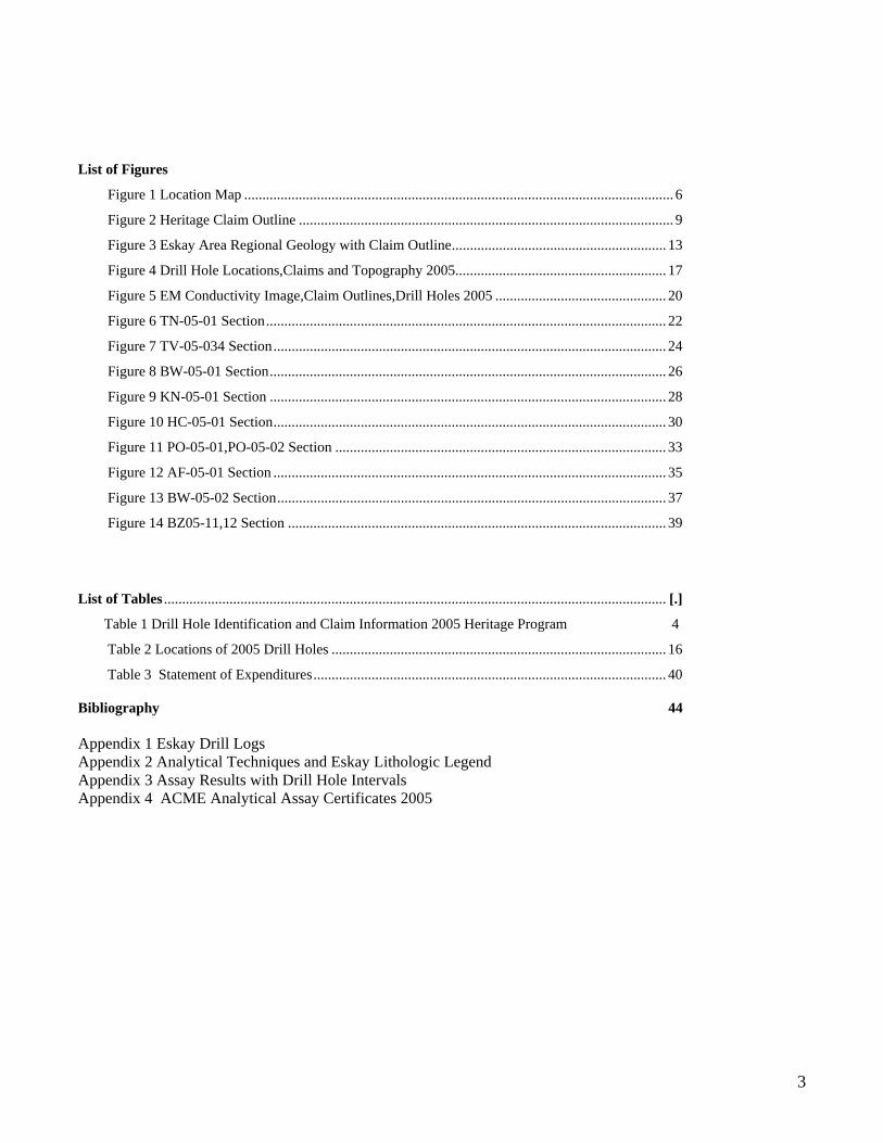
List of Figures
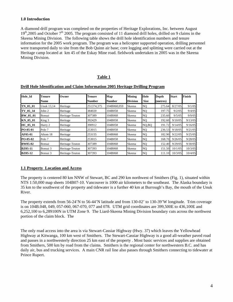
Figure 1 Location Map ...................................................................................................................... 6
Figure 2 Heritage Claim Outline ....................................................................................................... 9
Figure 3 Eskay Area Regional Geology with Claim Outline........................................................... 13
Figure 4 Drill Hole Locations,Claims and Topography 2005.......................................................... 17
Figure 5 EM Conductivity Image,Claim Outlines,Drill Holes 2005 ............................................... 20
Figure 6 TN-05-01 Section.............................................................................................................. 22
Figure 7 TV-05-034 Section............................................................................................................ 24
Figure 8 BW-05-01 Section............................................................................................................. 26
Figure 9 KN-05-01 Section ............................................................................................................. 28
Figure 10 HC-05-01 Section............................................................................................................ 30
Figure 11 PO-05-01,PO-05-02 Section ........................................................................................... 33
Figure 12 AF-05-01 Section ............................................................................................................ 35
Figure 13 BW-05-02 Section........................................................................................................... 37
Figure 14 BZ05-11,12 Section ........................................................................................................ 39
List of Tables .......................................................................................................................................... [.]
Table 1 Drill Hole Identification and Claim Information 2005 Heritage Program 4
Table 2 Locations of 2005 Drill Holes ............................................................................................ 16
Table 3 Statement of Expenditures................................................................................................. 40 Bibliography 44 Appendix 1 Eskay Drill Logs Appendix 2 Analytical Techniques and Eskay Lithologic Legend Appendix 3 Assay Results with Drill Hole Intervals Appendix 4 ACME Analytical Assay Certificates 2005
1.0 Introduction A diamond drill program was completed on the properties of Heritage Explorations, Inc. between August 19th,2005 and October 7th 2005. The program consisted of 11 diamond drill holes, drilled on 9 claims in the Skeena Mining Division. The following table shows the drill hole identification numbers and tenure information for the 2005 work program. The program was a helicopter supported operation, drilling personnel were transported daily to site from the Bob Quinn air base; core logging and splitting were carried out at the Heritage camp located at km 45 of the Eskay Mine road. fieldwork undertaken in 2005 was in the Skeena Mining Division. Table 1 Drill Hole Identification and Claim Information 2005 Heritage Drilling Program Hole_Id Tenure Owner Tenure Map Mining Hole Depth Start Finish
Name Number Number Division Size (metres)
TN_05_01 Unuk 13,14 Heritage 251374,375 104B068,059 Skeena NQ 275.64 8/27/05 9/1/05TV_05_34 John 2 Heritage 384020 104B058 Skeena NQ 197.75 9/2/05 9/4/05BW_05_01 Bonsai Heritage-Teuton 307389 104B068 Skeena NQ 235.60 9/5/05 9/9/05KN_05_01 King 3 Heritage 392429 104B058 Skeena NQ 192.60 9/10/05 9/13/05HC_05_01 Harry 2 Heritage 390912 104B058 Skeena NQ,BQ 191.72 9/14/05 9/16/05PO-05-01 Polo 7 Heritage 253015 104B058 Skeena NQ 236.53 9/18/05 9/21/05AF05-01 Aftom 18 Heritage 253155 104B068 Skeena NQ 182.90 9/22/05 9/25/05PO-05-02 Polo 7 Heritage 253015 104B058 Skeena NQ 168.70 9/26/05 9/28/05BW05-02 Bonsai Heritage-Teuton 307389 104B068 Skeena NQ 152.40 9/29/05 9/30/05BZ05-11 Bonsai 3 Heritage-Teuton 307393 104B068 Skeena NQ 151.50 10/1/05 10/3/05BZ05-12 Bonsai 3 Heritage-Teuton 307393 104B068 Skeena NQ 111.10 10/3/05 10/4/05
1.1 Property Location and Access
The property is centered 80 km NNW of Stewart, BC and 290 km northwest of Smithers (Fig. 1), situated within NTS 1:50,000 map sheets 104B07-10. Vancouver is 1000 air kilometers to the southeast. The Alaska boundary is 35 km to the southwest of the property and tidewater is a further 40 km at Burrough’s Bay, the mouth of the Unuk River. The property extends from 56-24’N to 56-44’N latitude and from 130-02’ to 130-39’W longitude. Trim coverage is on 104B.048, 049, 057-060, 067-070, 077 and 078. UTM grid coordinates are 399,500E to 436,100E and 6,252,100 to 6,289100N in UTM Zone 9. The Liard-Skeena Mining Division boundary cuts across the northwest portion of the claim block. The The only road access into the area is via Stewart-Cassiar Highway (Hwy. 37) which leaves the Yellowhead Highway at Kitwanga, 100 km west of Smithers. The Stewart-Cassiar Highway is a good all-weather paved road and passes in a northwesterly direction 25 km east of the property . Most basic services and supplies are obtained from Smithers, 500 km by road from the claims. Smithers is the regional center for northwestern B.C. and has daily air, bus and trucking services. A main CNR rail line also passes through Smithers connecting to tidewater at Prince Rupert.
4

5
The Heritage camp is located at km 45 of a 60 km gravel road which accesses the Eskay Creek Mine off the Stewart-Cassiar Highway. The property is irregular in shape but overall extends 35 km east-west and 30 km north-south. The bulk of the claims are at the headwaters of the Unuk River which drains southwesterly for 75 km to tidewater in Alaska. All access on the property is by helicopter except in the immediate area of the Eskay mine road.
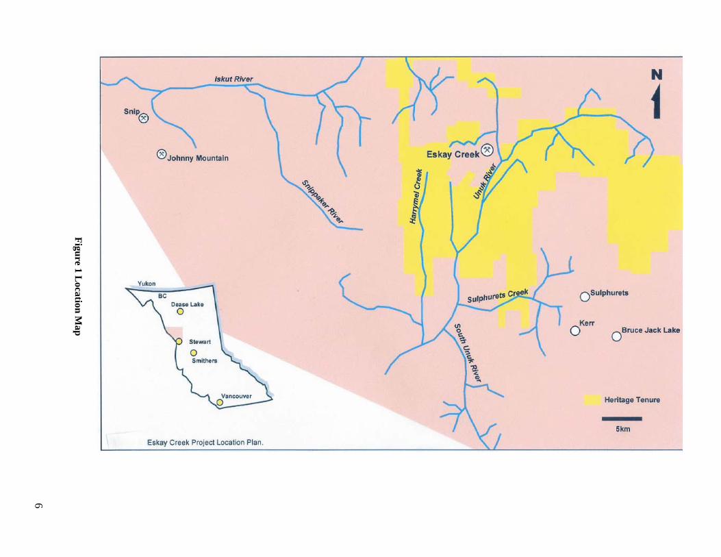
Figure 1 L
ocation Map
6

7
In 2002 , 2003, 2004 and 2005 Heritage worked out of a trailer/tent camp located at km 45 of the 60 km gravel road which accesses the Eskay Creek Mine off the Stewart-Cassiar Highway. This is a private road and permits are required from Barrick Gold Corporation to use the road and the campsite. Fixed wing access to the area can be made to an airstrip located along Hwy. 37 at Bob Quinn Lake 40 km northeast of the property. All access on the property is by helicopter except in the immediate area of the mine road. Elevations above 1000 meters, as in the SIB area, are sparsely timbered and can be easily worked by helicopter. Lower elevations are more difficult, requiring chopper pads or creek/river openings accessible by helicopter. Much of the topography is quite rugged and traversing can be difficult and/or dangerous.
8
1.2 Property Description The property is irregular in shape but overall extends 35 km east-west and 30 km north-south. The bulk of the claims are at the headwaters of the Unuk River which drains southwesterly for 75 km to tidewater in Alaska. A small northwestern group of claims drains northerly into the Iskut River. Property elevations range from 150 meters to 2200 meters. The property is in a coastal climate zone and receives significant rainfall and snowfall. Due to the high precipitation icefields occupy the higher elevations and glaciers extend down the adjoining drainages, although presently the glaciers are in retreat. The Treaty, AP, Tarn and Johns Peak areas in particular have a significant glacier component.
Heritage Explorations Ltd. has acquired mineral rights over an extensive area (53,283 hectares) in the Eskay Creek region of north-western BC. The claims cover highly prospective terrain with potential for polymetallic, precious metal-rich deposits similar to the Eskay Creek mine which is immediately adjacent to the Heritage landholdings. This report documents 11 drill holes completed in August to October 2005. The Eskay property consists of 2,120 claim-units and one mineral lease, together covering approximately 53,283 hectares or 132,906 acres. (Figure 2 Heritage Claim Outline) The western portion of the claim package surrounds the Eskay Creek gold mine, owned and operated by Barrick Gold Corporation. The earliest expiry date for the mineral tenures is August 07, 2008. The single mineral Lease (ML 329001) is located at the summit of the Eskay Creek mine access road. Two blocks of claims are held by Heritage Explorations Ltd. under option from Teuton Resources Ltd. The Bonsai Option covers 9 claims at the headwaters of Harrymel Creek. The Treaty Option covers 5 claims at the head of Treaty Creek.
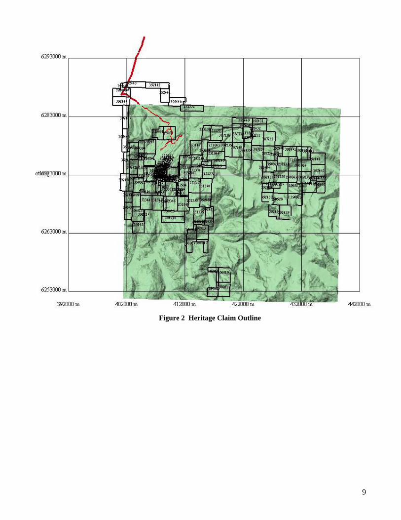
Figure 2 Heritage Claim Outline
9
10
1.3 Property History
The Eskay property lies at the north end of the 150 km long historic Stewart mining district that extends southerly past Stewart to the Anyox area on Alice Arm. Mining in this region dates back to the early 1900s. In the immediate Iskut – Eskay area the first significant exploration began in the early 1930s when Tom Mackay and his associates started prospecting in the Ketchum Creek and Eskay Creek areas. This venture was backed by the Premier Mine at Stewart. Thirty prospects were identified, including the 21 zone. The claims were intermittently explored until 1988 when a joint venture of Stikine Resources and Calpine Resources confirmed massive sulphides at the 21 Zone and drilled hole 109, the “discovery hole” which intersected 61 meters averaging 99 gpt Au and 29 gpt Ag. The Eskay Creek discovery in 1988 initiated a staking rush and generated considerable interest and work in the Iskut area. Most of the prospects and showings on the Heritage claims, such as the Bonsai (1992), TV (1996). Jeff (1988), AP (1989), Tarn (1989) and the R-Grid (1988) were discovered in the exploration activity following the Eskay Creek discovery. The initial work on the Eskay Project for Heritage involved data capture, review and analysis by Geoinformatics beginning in 2001. Data collected included 332 drill holes, 34,000 geochemical samples of various types, 36 geological outcrop and interpretation maps, 29 geophysical datasets, mineral occurrence information, topographic and cadastral data. The culmination of the historical data compilation and processing phase of the project was the creation of a new geological interpretation map for the Eskay region.
The recent period of fieldwork began in 2001 when a geochemical orientation survey was undertaken in the general Eskay area to determine an appropriate stream sediment technique to locate the most prospective terrain (McGuigan and Gilmour, 2001). It was concluded that sieved silts from the high energy environment provided the best setting for consistent gold results. The 2002 field season encompassed a reconnaissance high energy sieved silt sampling program covering potential mineralized areas of the property, geological mapping of the SIB Claims, and 3,075 meters of diamond drilling on the SIB claims. The 2003 field program continued the primary effort on the SIB claims and undertook exploration of other showings/zones on the property, particularly the Bonsai, Polo, TV-Jeff, Tarn and Treaty prospects. The mapping at SIB initiated in 2002 was continued to complete the entire SIB claims at 1:1000 scale. Diamond drilling (3,840 meters in 14 holes) consisted of three holes in the Battleship Knoll area, seven holes on the new Hexagon structure, a large sericite-pyrite alteration zone on the east side of the SIB claims, one hole at the Lulu Zone and three holes on the Bonsai showing. Drilling at Bonsai in 2003 intersected significant low grade gold/silver mineralization in pyritic rhyolite breccia, beneath the main gossan outcrop. The mineralized zone remained open at depth and to the south providing an excellent target for future exploration. One additional hole was added in 2004. This hole was located 69 meters south (along strike) from drill hole BZ 03-08. The hole intersected 28 meters of brecciated rhyolite with a pyrite-rich matrix, similar to the 2003 holes. Assay values were up to 0.35 gpt gold and averaged 0.24 gpt Au over 10.0 meters. Fieldwork at Treaty Creek in 2003 by Peter Lewis greatly improved the knowledge and understanding of the various zones in the area. The geological mapping and evaluation highlighted a number of areas for follow up work. Re-evaluation of airborne EM data indicated a porphyry target 1.5 kms southeast of the East Treaty (Eureka) prospect. The porphyry target was drill tested in 2004 with a 496 meter hole. Results were disappointing. Unaltered intermediate to mafic volcaniclastics with minor argillites were intersected.
An airborne EM-magnetic survey was flown late in the 2004 field season. Both the Eskay-SIB trend and the Treaty Glacier areas were covered. The survey was undertaken by Aeroquest Limited using their AeroTEM time domain system. The survey was flown in the East-West direction at 150 meter line spacing. The survey was completed using a helicopter with terrain clearance of approximately 30 meters. The survey totaled 2508 line kilometers of flying and data acquisition. Time domain EM and magnetic data was captured.
After the data was transmitted to Geoinformatics; conductive anomalies were chosen for drilling in 2005. The selection of anomalies was based on a forward-modeling approach, using the dimensions of the Eskay orebody and an assumed conductivity to calculate the response expected from a similar body. Seven conductive anomalies were selected for drilling, based on conductive response, stratigraphic position, local geochemical anomalism and
11
depth. Some of the conductive anomalies chosen were selected when found in association with Texas Creek plutons, as a possible skarn or SNIP type target.
Nine holes were drilled into seven EM anomalies, an additional two holes were drilled at the Bonsai showing, as follow up to previous drilling. All drill holes were moved with helicopter support and pads built on the steep and rough terrain. None of the drill holes encountered significant gold values, but two holes intersected significant results. Drill hole HC-05-01,drilled west of Harrymel Creek, intersected weak copper, zinc and silver mineralization. Drill hole PO-05-01 intersected a massive pyrite bed and mercury anomalous debris flow mudstones, as well as silicification and stringer pyrite in Salmon River basalt. The mineralization is located below 50 meters of Bowser mudstones. The massive-sulphide style mineralization is located at the top of the Salmon River Formation and is located in the Unuk River Syncline.
12
1.4 Regional Geology
The Eskay Project is located along the western margin of Stikinia, one of the major accreted terranes that became incorporated into western North America along the western boundary of the Intermontane Belt of northwest British Columbia. Stikinia is comprised of well stratified Lower Devonian to Middle Jurassic volcanic and sedimentary strata and plutonic rocks. The volcanics and sediments formed within or adjacent to volcanic arcs and the plutonic rocks are generally co-magmatic with the volcanics. Within the Eskay region Stikinia is composed of four major tectnostratigraphic assemblages: 1) multiple deformed and metamorphosed clastic, carbonate and volcanic rocks of the Upper Paleozoic Stikine Assemblage;
2) Upper Triassic volcanic and sedimentary rocks of the Stuhini group; 3) Lower and Middle Jurassic subaerial and submarine volcanic and sedimentary rocks of the Hazelton Group; and
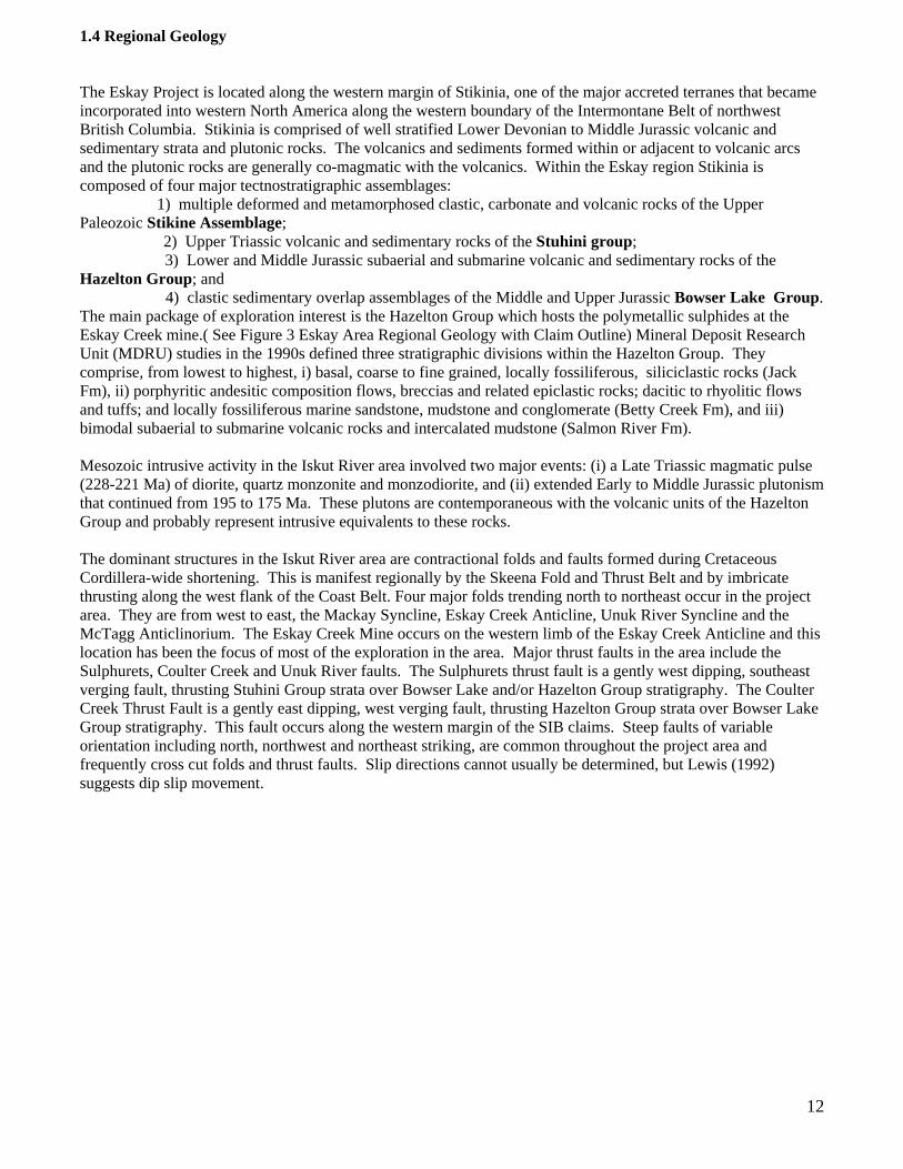
4) clastic sedimentary overlap assemblages of the Middle and Upper Jurassic Bowser Lake Group. The main package of exploration interest is the Hazelton Group which hosts the polymetallic sulphides at the Eskay Creek mine.( See Figure 3 Eskay Area Regional Geology with Claim Outline) Mineral Deposit Research Unit (MDRU) studies in the 1990s defined three stratigraphic divisions within the Hazelton Group. They comprise, from lowest to highest, i) basal, coarse to fine grained, locally fossiliferous, siliciclastic rocks (Jack Fm), ii) porphyritic andesitic composition flows, breccias and related epiclastic rocks; dacitic to rhyolitic flows and tuffs; and locally fossiliferous marine sandstone, mudstone and conglomerate (Betty Creek Fm), and iii) bimodal subaerial to submarine volcanic rocks and intercalated mudstone (Salmon River Fm).
Mesozoic intrusive activity in the Iskut River area involved two major events: (i) a Late Triassic magmatic pulse (228-221 Ma) of diorite, quartz monzonite and monzodiorite, and (ii) extended Early to Middle Jurassic plutonism that continued from 195 to 175 Ma. These plutons are contemporaneous with the volcanic units of the Hazelton Group and probably represent intrusive equivalents to these rocks.
The dominant structures in the Iskut River area are contractional folds and faults formed during Cretaceous Cordillera-wide shortening. This is manifest regionally by the Skeena Fold and Thrust Belt and by imbricate thrusting along the west flank of the Coast Belt. Four major folds trending north to northeast occur in the project area. They are from west to east, the Mackay Syncline, Eskay Creek Anticline, Unuk River Syncline and the McTagg Anticlinorium. The Eskay Creek Mine occurs on the western limb of the Eskay Creek Anticline and this location has been the focus of most of the exploration in the area. Major thrust faults in the area include the Sulphurets, Coulter Creek and Unuk River faults. The Sulphurets thrust fault is a gently west dipping, southeast verging fault, thrusting Stuhini Group strata over Bowser Lake and/or Hazelton Group stratigraphy. The Coulter Creek Thrust Fault is a gently east dipping, west verging fault, thrusting Hazelton Group strata over Bowser Lake Group stratigraphy. This fault occurs along the western margin of the SIB claims. Steep faults of variable orientation including north, northwest and northeast striking, are common throughout the project area and frequently cross cut folds and thrust faults. Slip directions cannot usually be determined, but Lewis (1992) suggests dip slip movement.
Figure 3 E
skay Area R
egional Geology w
ith Claim
Outline
13
14
1.5 Personnel and Logistics Drilling was carried out by Full Force Diamond Drilling of Peachland ,B.C. Full Force provided a hydraulic diamond drill for the program. Full Force employed two drillers and two helpers, working 12-hour shifts seven days a week. Drillers were housed and fed at the Bob Quinn Bed and Breakfast, 2 miles south of the Bob Quinn airstrip on the Cassiar Highway. Helicopter services were provided by Matrix Helicopter Solutions Inc. The helicopter was based out of the Bob Quinn airstrip, completed all drill moves and ferried drillers to the project area at each shift change. Helicopter provided transportation to the field for pad building crews and geologists. Pilots were stationed at Bob Quinn. Location of drill holes, drill hole logging, sample layout, on-site supervision, and investigation of anomaly areas was completed by three geologists. All core was logged and photographed by three geologists.The geologists were Tony Worth B.Sc. of GeoInformatics, Warren Bates B.Sc. P.Geo. Vice President Exploration of St.Andrew Goldfields and Bill Burnett M.Sc. of Mystery Creek Mining. Qualifications are listed in the Statement of Qualifications. Off site supervision and permitting were completed by Jerry Bidwell B.Sc. P. Geo., on Heritage’ behalf by Geoinformatics. Pad building and site preparation were carried out by Arden Braden, Tim Pynn, Paul Macdonald and Jim Donaldson of MinConsult services. Core splitting was completed by Chris Woolverton and John Greenwood of MinConsult Services. Expediting Services were provided by Nugget Expediting of Smithers ,British Columbia. Safety coordination and first aid services were provided by Pat McIntosh contracting for Nuggett Expediting. Hole positioning was accomplished using a WAAS enabled Magellan GPS unit; coordinates and orientations placed with compass. The downhole surveying was completed with a Sperry Sun instrument and acid tests were performed as required. Geologists, field crews, core splitters and the safety coordinator were housed at Bell 2 lodge on Highway 37 Highway. The crews were transported daily by truck to the core splitting facility on the Eskay access road. Work was completed under Mines Act Permit MX-1-587, Approval #05-0101000-0816. All the drill pads were dismantled and lumber flown to two locations southwest of the Eskay mine.
15
1.6 Core Preparation, Assay Method ,Logging ,Quality Control A core logging facility was set up on kilometer 45 of the Eskay Mine access road. Core was transported by helicopter from the drill site to this location. Core was logged and split by core saw at this location. Core resides at a core storage location at kilometer 54 of the Eskay access road. Split core samples were shipped directly from the core logging facility by Bandstra to ACME Analytical Labs in Vancouver for sample preparation and assay. Samples were analyzed by ACME, using ICP-MS Method 1F30. A description of the method is given in Appendix 2- Analytical Techniques. Core was flown directly from the drill and loaded into the core tent. Sample intervals and lithologic contacts were measured and laid out by the geologists. Geologic logging was entered directly into Excel sheets. Core samples were split into halves with a coresaw. For the majority of samples one side of core was submitted for sample,the other side retained in the core box. For every twentieth sample, a re-split of the retained material (1/4 core) was submitted as a sample duplicate. Average sample length was 1-metre. A total of 866 samples were submitted for analysis. ACME provided theirown internal standards for the assaying procedures. Analytical results are given as Assay Results correlated with drill hole interval in Appendix 3, Sample intervals and results. Digital copies of assay certificates are provide in Appendix 4-Assay Certificates
16
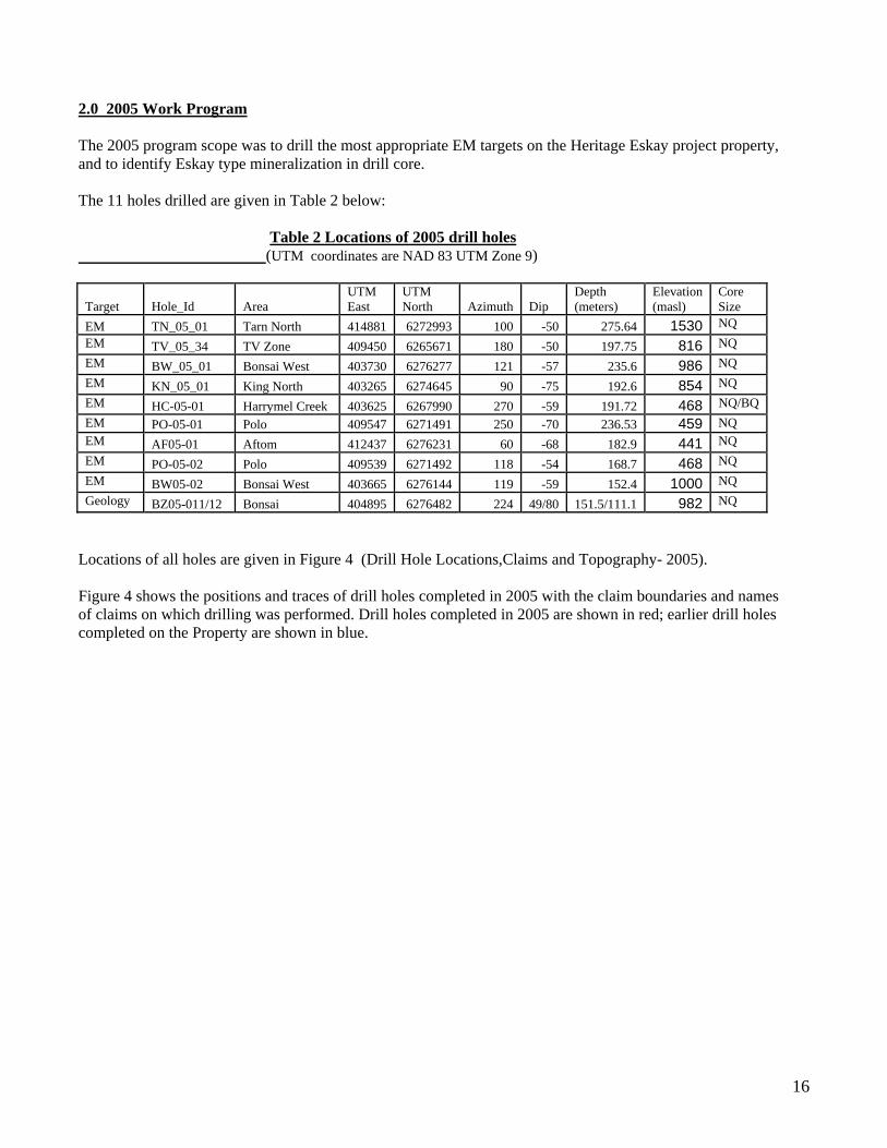
2.0 2005 Work Program The 2005 program scope was to drill the most appropriate EM targets on the Heritage Eskay project property, and to identify Eskay type mineralization in drill core. The 11 holes drilled are given in Table 2 below: Table 2 Locations of 2005 drill holes (UTM coordinates are NAD 83 UTM Zone 9)
Target Hole_Id Area UTM East
UTM North Azimuth Dip
Depth (meters)
Elevation (masl)
Core Size
EM TN_05_01 Tarn North 414881 6272993 100 -50 275.64 1530 NQ EM TV_05_34 TV Zone 409450 6265671 180 -50 197.75 816 NQ EM BW_05_01 Bonsai West 403730 6276277 121 -57 235.6 986 NQ EM KN_05_01 King North 403265 6274645 90 -75 192.6 854 NQ EM HC-05-01 Harrymel Creek 403625 6267990 270 -59 191.72 468 NQ/BQ EM PO-05-01 Polo 409547 6271491 250 -70 236.53 459 NQ EM AF05-01 Aftom 412437 6276231 60 -68 182.9 441 NQ EM PO-05-02 Polo 409539 6271492 118 -54 168.7 468 NQ EM BW05-02 Bonsai West 403665 6276144 119 -59 152.4 1000 NQ Geology BZ05-011/12 Bonsai 404895 6276482 224 49/80 151.5/111.1 982 NQ
Locations of all holes are given in Figure 4 (Drill Hole Locations,Claims and Topography- 2005). Figure 4 shows the positions and traces of drill holes completed in 2005 with the claim boundaries and names of claims on which drilling was performed. Drill holes completed in 2005 are shown in red; earlier drill holes completed on the Property are shown in blue.
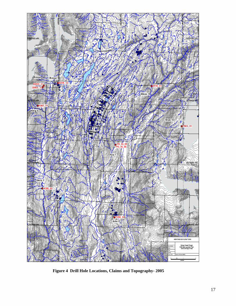
Figure 4 Drill Hole Locations, Claims and Topography- 2005
17
18
2. 1 2005 Geoinformatics Targetting The 2004 airborne EM and magnetic survey data were processed to produce various products including the following:
- The GEX “bag full” of images derived from the complete sets of geoinformatics potential field filters. The recent survey was merged with earlier data to produce a more widespread coverage.
- Magnetic “Worms”. - conductivity depth images (CDI’s) of the EM data produced from 1D inversions along each survey
line. - 3D conductivity grids (figure 1).
Interpretation of profile EM data and CDI’s to identify conductors possibly caused by massive sulphide bodies was completed. Ranking of these conductors was also been completed. The airborne EM and magnetics survey completed in 2004 survey was extensively reviewed and interpreted by Geoinformatics (GXL). GXL identified 32 EM anomalies and considered several of these to be high priority targets for drill testing. The priority targets are discrete EM conductors with a high probability of being sourced from massive sulphide mineralization.
2.1.1 Drill Targets The EM drill targets considered to warrant drill testing in 2005 are outlined below and shown in Figure 5- ( EM Conductivity Image, Claim Outlines, Drill Holes-2005).Figure 5 again shows drill holes completed in red against a background conductivity image developed from the 2005 Aeroqest survey.Claims names on which holes were drilled are shown.
• Tarn North 414950E, 6272940N (UTM, NAD83) A strongly conductive discrete anomaly,300m x 300m dimensions, steeply dipping (discordant to stratigraphy). The target model was fault controlled epithermal massive sulphide veins or lenses. Tested by TN-05-01.
• Bonsai West 403847E, 6276253N – Teuton Joint Venture A moderately conductive discrete anomaly, 600m x 100m x 50m dimensions, steeply dipping (discordant to stratigraphy?). The target model was intrusion related skarn or thermal aureole massive sulphide mineralisation. Tested by BW-05-01 and Bw-05-02.
• Aftom 18 412538E 6276278N
A moderately conductive discrete anomaly, 400m x 150m dimensions, 120m deep, flat dipping (parallel to stratigraphy). Eastern limb of Eskay anticline. The target model was Eskay Creek style massive sulphide mineralisation. Tested by AF-05-01.
• TV 409329E 6265601N A very strongly conductive discrete anomaly, 100m x 400m dimensions, shallow dipping (parallel to stratigraphy). The target model was Eskay Creek style massive sulphide mineralisation. Tested by drill hole TV-05-034
19
• Polo 409499E 6271435N A moderately conductive broad anomaly, 400m x 150m x 100m dimensions, shallow dipping (parallel to stratigraphy?). Eastern limb of Eskay anticline. The target model was Eskay Creek style massive sulphide mineralisation. Tested by drill hole PO-05-01 and PO-05-02
• Harrymel Creek 403593E 6267992N A very strongly conductive discrete anomaly, 250m x 100m dimensions, flat dipping (parallel to stratigraphy?). The target model was Eskay Creek style massive sulphide mineralisation. Tested by drill hole HC-05-01.
• King 3 403257E 6274608N
A moderately conductive discrete anomaly, 250m x 100m dimensions, steeply dipping (discordant to stratigraphy?). The target model is fault controlled epithermal massive sulphide veins or lenses, or intrusion related thermal aureole massive sulphide mineralisation. Tested by drill hole KN-05-01.
Of the 11 holes drilled in 2005, nine were drilled to test EM anomalies, and two were follow-up holes at the Bonsai Zone. On drill holes that were drilled to intersect conductive mineralization; the section will show the interpreted location of the EM anomaly in red outline.
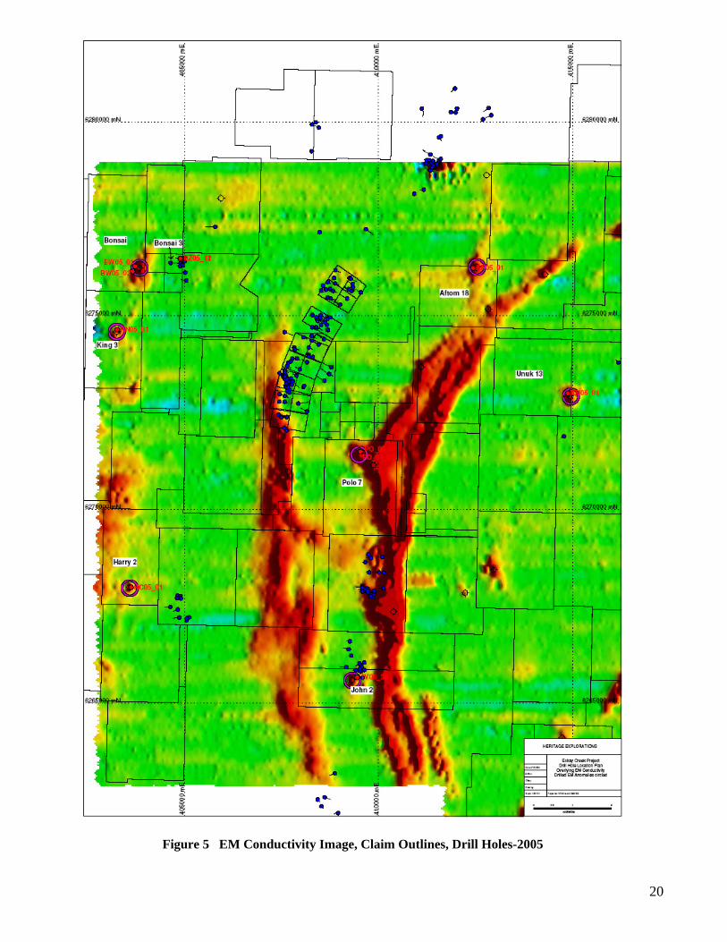
Figure 5 EM Conductivity Image, Claim Outlines, Drill Holes-2005
20
21
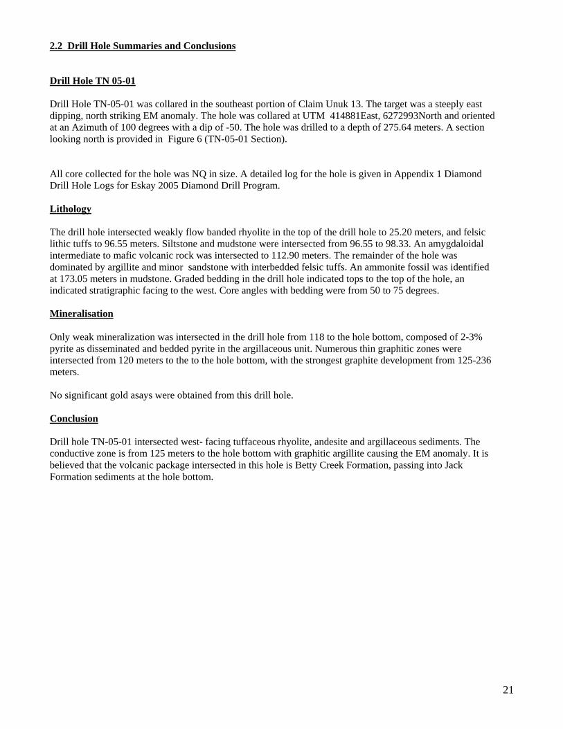
2.2 Drill Hole Summaries and Conclusions Drill Hole TN 05-01 Drill Hole TN-05-01 was collared in the southeast portion of Claim Unuk 13. The target was a steeply east dipping, north striking EM anomaly. The hole was collared at UTM 414881East, 6272993North and oriented at an Azimuth of 100 degrees with a dip of -50. The hole was drilled to a depth of 275.64 meters. A section looking north is provided in Figure 6 (TN-05-01 Section). All core collected for the hole was NQ in size. A detailed log for the hole is given in Appendix 1 Diamond Drill Hole Logs for Eskay 2005 Diamond Drill Program. Lithology The drill hole intersected weakly flow banded rhyolite in the top of the drill hole to 25.20 meters, and felsic lithic tuffs to 96.55 meters. Siltstone and mudstone were intersected from 96.55 to 98.33. An amygdaloidal intermediate to mafic volcanic rock was intersected to 112.90 meters. The remainder of the hole was dominated by argillite and minor sandstone with interbedded felsic tuffs. An ammonite fossil was identified at 173.05 meters in mudstone. Graded bedding in the drill hole indicated tops to the top of the hole, an indicated stratigraphic facing to the west. Core angles with bedding were from 50 to 75 degrees. Mineralisation Only weak mineralization was intersected in the drill hole from 118 to the hole bottom, composed of 2-3% pyrite as disseminated and bedded pyrite in the argillaceous unit. Numerous thin graphitic zones were intersected from 120 meters to the to the hole bottom, with the strongest graphite development from 125-236 meters. No significant gold asays were obtained from this drill hole. Conclusion Drill hole TN-05-01 intersected west- facing tuffaceous rhyolite, andesite and argillaceous sediments. The conductive zone is from 125 meters to the hole bottom with graphitic argillite causing the EM anomaly. It is believed that the volcanic package intersected in this hole is Betty Creek Formation, passing into Jack Formation sediments at the hole bottom.
22 Figure 6 TN-05-01 Section
23
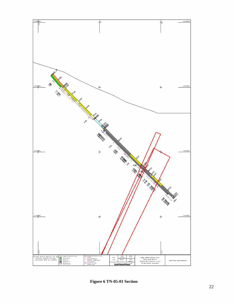
Drill Hole TV-05-34 Drill hole TV-05-34 was drilled to test a flat lying EM anomaly located immediately south of known mineralization at the TV zone. Gold-silver mineralization had been obtained in previous work in the TV area as summarized by MacGuigan (2002). The drill hole was collared at 409450 East, 6265671 North at an elevation of 816 meters, in the north-central portion of the John 2 claim. The hole was drilled to the south (Azimuth 180) at a dip of -50 for 197.75 meters. A section looking west is provided in Figure 7. (TV-05-034 Section) All core collected for the hole was NQ in size. A detailed log for the hole is given in Appendix 1 Diamond Drill Hole Logs for Eskay 2005 Diamond Drill Program. Lithology The drill hole intersected fine grained, amygdaloidal basalt to 77.96 meters. From 77.96 meters to 93.10 meters the drill hole intersected siltstones, sandstones and mudstones. An argillic unit with moderate graphite from 77.96 to 79.10 was weakly conductive using an ohmmeter. From 93.10 the drill hole intersected andesitic lapilli and ash tuff. Mineralisation The dominant mineralisation intersected in TV-05-34 was a system of anastamosing pyrrhotite –pyrite stringers from 93.50 meters to 197.75 meters. The sulphide stringers form 2% to 8% of the rock mass ,are 1-3 mm wide, and are dominated by pyrrhotite with subordinate pyrite. Pyrrhotite is about 4-5 times as abundant as pyrite. No significant gold or silver mineralization was intersected. Anomalous base metals were not present nor were there any significant anomalies in As,Sb, or Hg. Conclusion The conductor is probably caused by graphite in the interval from 77.96 to 79.10, which agrees with the modeled conductor location shown on section. The statigraphic interval intersected is believed to be Upper Salmon River Formation.
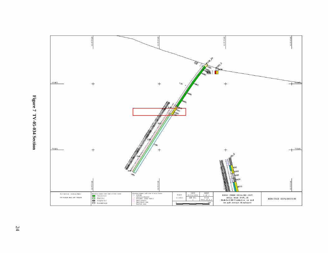
Figure 7 T
V-05-034 Section
24
25
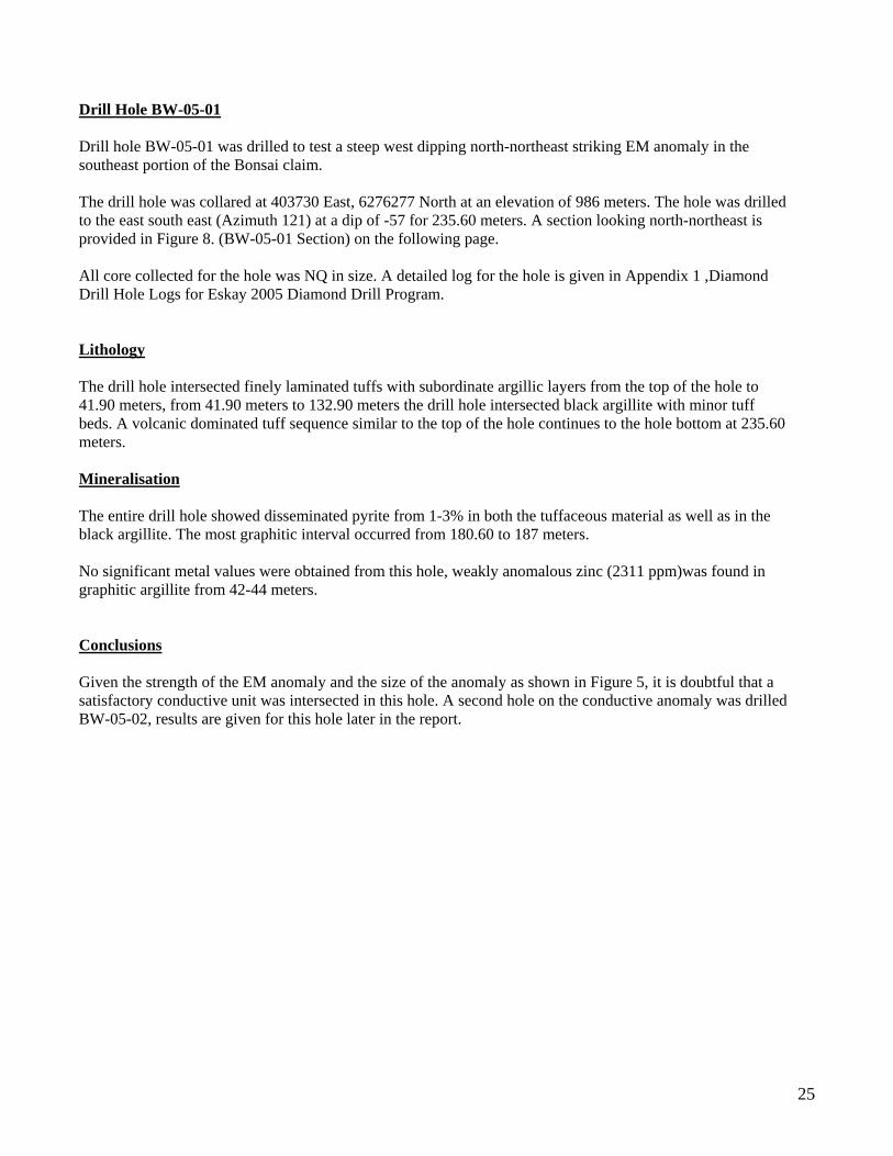
Drill Hole BW-05-01 Drill hole BW-05-01 was drilled to test a steep west dipping north-northeast striking EM anomaly in the southeast portion of the Bonsai claim. The drill hole was collared at 403730 East, 6276277 North at an elevation of 986 meters. The hole was drilled to the east south east (Azimuth 121) at a dip of -57 for 235.60 meters. A section looking north-northeast is provided in Figure 8. (BW-05-01 Section) on the following page. All core collected for the hole was NQ in size. A detailed log for the hole is given in Appendix 1 ,Diamond Drill Hole Logs for Eskay 2005 Diamond Drill Program. Lithology The drill hole intersected finely laminated tuffs with subordinate argillic layers from the top of the hole to 41.90 meters, from 41.90 meters to 132.90 meters the drill hole intersected black argillite with minor tuff beds. A volcanic dominated tuff sequence similar to the top of the hole continues to the hole bottom at 235.60 meters. Mineralisation The entire drill hole showed disseminated pyrite from 1-3% in both the tuffaceous material as well as in the black argillite. The most graphitic interval occurred from 180.60 to 187 meters. No significant metal values were obtained from this hole, weakly anomalous zinc (2311 ppm)was found in graphitic argillite from 42-44 meters. Conclusions Given the strength of the EM anomaly and the size of the anomaly as shown in Figure 5, it is doubtful that a satisfactory conductive unit was intersected in this hole. A second hole on the conductive anomaly was drilled BW-05-02, results are given for this hole later in the report.
Figure 8 BW
-05-01 Section
26
27
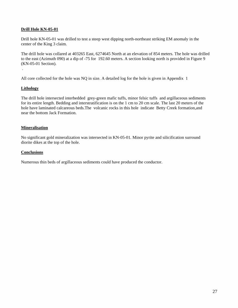
Drill Hole KN-05-01 Drill hole KN-05-01 was drilled to test a steep west dipping north-northeast striking EM anomaly in the center of the King 3 claim. The drill hole was collared at 403265 East, 6274645 North at an elevation of 854 meters. The hole was drilled to the east (Azimuth 090) at a dip of -75 for 192.60 meters. A section looking north is provided in Figure 9 (KN-05-01 Section). . All core collected for the hole was NQ in size. A detailed log for the hole is given in Appendix 1 Lithology The drill hole intersected interbedded grey-green mafic tuffs, minor felsic tuffs and argillaceous sediments for its entire length. Bedding and interstratification is on the 1 cm to 20 cm scale. The last 20 meters of the hole have laminated calcareous beds.The volcanic rocks in this hole indicate Betty Creek formation,and near the bottom Jack Formation. Mineralisation No significant gold mineralization was intersected in KN-05-01. Minor pyrite and silicification surround diorite dikes at the top of the hole. Conclusions Numerous thin beds of argillaceous sediments could have produced the conductor.
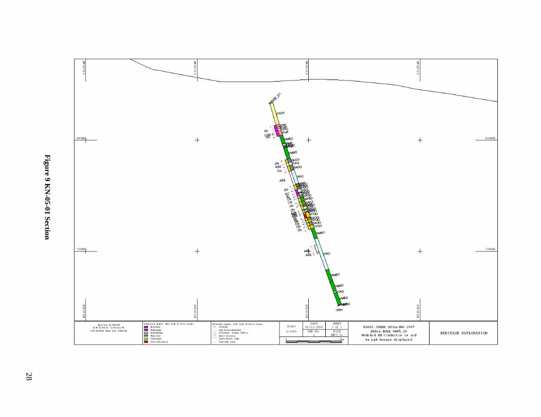
Figure 9 K
N-05-01 Section
28
29
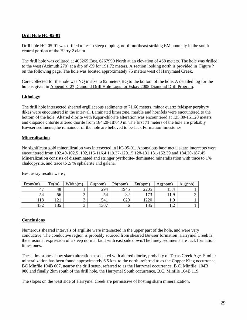
Drill Hole HC-05-01 Drill hole HC-05-01 was drilled to test a steep dipping, north-northeast striking EM anomaly in the south central portion of the Harry 2 claim. The drill hole was collared at 403265 East, 6267990 North at an elevation of 468 meters. The hole was drilled to the west (Azimuth 270) at a dip of -59 for 191.72 meters. A section looking north is provided in Figure ? on the following page. The hole was located approximately 75 meters west of Harrymael Creek. Core collected for the hole was NQ in size to 82 meters,BQ to the bottom of the hole. A detailed log for the hole is given in Appendix 2? Diamond Drill Hole Logs for Eskay 2005 Diamond Drill Program. Lithology The drill hole intersected sheared argillaceous sediments to 71.66 meters, minor quartz feldspar porphyry dikes were encountered in the interval. Laminated limestone, marble and hornfels were encountered to the bottom of the hole. Altered diorite with Kspar-chlorite alteration was encountered at 135.80-151.20 meters and diopside chlorite altered diorite from 184.20-187.40 m. The first 71 meters of the hole are probably Bowser sediments,the remainder of the hole are believed to be Jack Formation limestones. Mineralisation No significant gold mineralization was intersected in HC-05-01. Anomalous base metal skarn intercepts were encountered from 102.40-102.5 ,102,116-116.4,119.37-120.15,128-131,131-152.39 and 184.20-187.45. Mineralization consists of disseminated and stringer pyrrhotite- dominated mineralization with trace to 1% chalcopyrite, and trace to .5 % sphalerite and galena. Best assay results were ; From(m) To(m) Width(m) Cu(ppm) Pb(ppm) Zn(ppm) Ag(ppm) Au(ppb)
47 48 1 294 1945 2205 15.4 1 54 56 2 54 32 173 11.9 2
118 121 3 541 629 1220 1.9 1 132 135 3 1307 6 135 1.2 1
Conclusions Numerous sheared intervals of argillite were intersected in the upper part of the hole, and were very conductive. The conductive region is probably sourced from sheared Bowser formation .Harrymel Creek is the erosional expression of a steep normal fault with east side down.The limey sediments are Jack formation limestones. These limestones show skarn alteration associated with altered diorite, probably of Texas Creek Age. Similar mineralization has been found approximately 6.5 km. to the north, referred to as the Copper King occurrence, BC Minfile 104B 007, nearby the drill setup, referred to as the Harrymel occurrence, B.C. Minfile 104B 080,and finally 2km south of the drill hole, the Harrymel South occurrence, B.C. Minfile 104B 119. The slopes on the west side of Harrymel Creek are permissive of hosting skarn mineralization.
30
Figure 10 HC
-05-01 Section
31
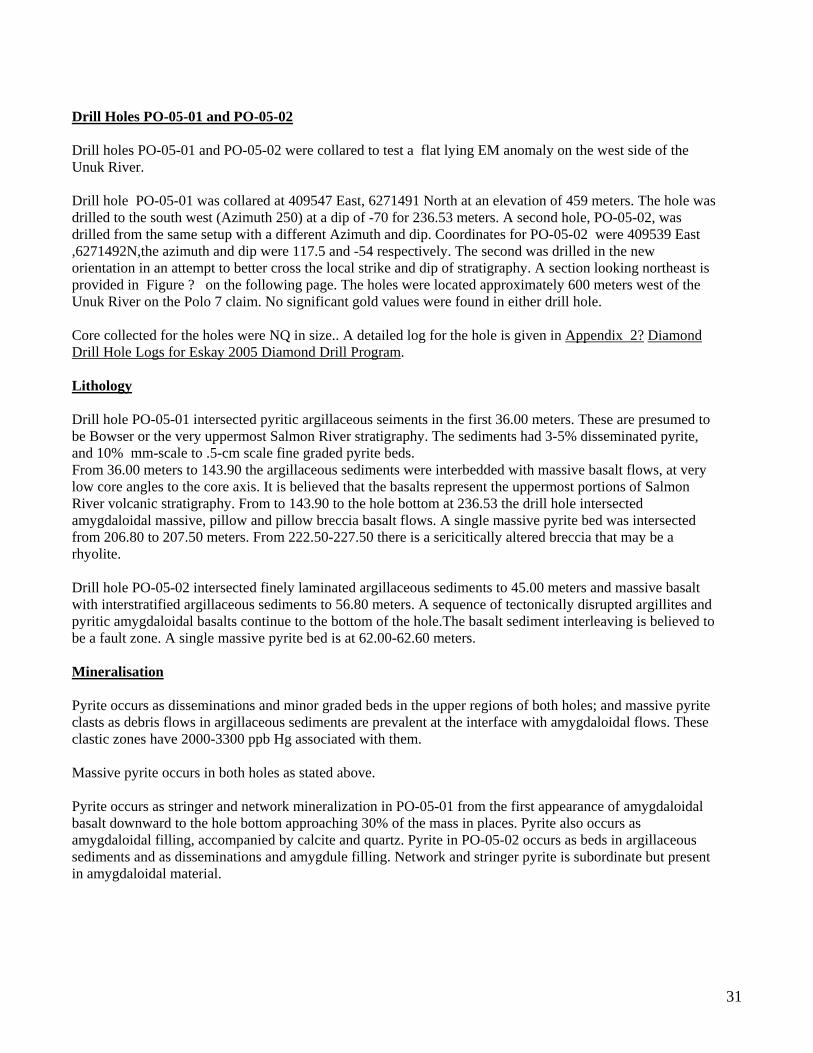
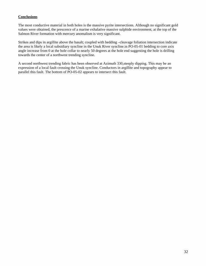
Drill Holes PO-05-01 and PO-05-02 Drill holes PO-05-01 and PO-05-02 were collared to test a flat lying EM anomaly on the west side of the Unuk River. Drill hole PO-05-01 was collared at 409547 East, 6271491 North at an elevation of 459 meters. The hole was drilled to the south west (Azimuth 250) at a dip of -70 for 236.53 meters. A second hole, PO-05-02, was drilled from the same setup with a different Azimuth and dip. Coordinates for PO-05-02 were 409539 East ,6271492N,the azimuth and dip were 117.5 and -54 respectively. The second was drilled in the new orientation in an attempt to better cross the local strike and dip of stratigraphy. A section looking northeast is provided in Figure ? on the following page. The holes were located approximately 600 meters west of the Unuk River on the Polo 7 claim. No significant gold values were found in either drill hole. Core collected for the holes were NQ in size.. A detailed log for the hole is given in Appendix 2? Diamond Drill Hole Logs for Eskay 2005 Diamond Drill Program. Lithology Drill hole PO-05-01 intersected pyritic argillaceous seiments in the first 36.00 meters. These are presumed to be Bowser or the very uppermost Salmon River stratigraphy. The sediments had 3-5% disseminated pyrite, and 10% mm-scale to .5-cm scale fine graded pyrite beds. From 36.00 meters to 143.90 the argillaceous sediments were interbedded with massive basalt flows, at very low core angles to the core axis. It is believed that the basalts represent the uppermost portions of Salmon River volcanic stratigraphy. From to 143.90 to the hole bottom at 236.53 the drill hole intersected amygdaloidal massive, pillow and pillow breccia basalt flows. A single massive pyrite bed was intersected from 206.80 to 207.50 meters. From 222.50-227.50 there is a sericitically altered breccia that may be a rhyolite. Drill hole PO-05-02 intersected finely laminated argillaceous sediments to 45.00 meters and massive basalt with interstratified argillaceous sediments to 56.80 meters. A sequence of tectonically disrupted argillites and pyritic amygdaloidal basalts continue to the bottom of the hole.The basalt sediment interleaving is believed to be a fault zone. A single massive pyrite bed is at 62.00-62.60 meters. Mineralisation Pyrite occurs as disseminations and minor graded beds in the upper regions of both holes; and massive pyrite clasts as debris flows in argillaceous sediments are prevalent at the interface with amygdaloidal flows. These clastic zones have 2000-3300 ppb Hg associated with them. Massive pyrite occurs in both holes as stated above. Pyrite occurs as stringer and network mineralization in PO-05-01 from the first appearance of amygdaloidal basalt downward to the hole bottom approaching 30% of the mass in places. Pyrite also occurs as amygdaloidal filling, accompanied by calcite and quartz. Pyrite in PO-05-02 occurs as beds in argillaceous sediments and as disseminations and amygdule filling. Network and stringer pyrite is subordinate but present in amygdaloidal material.
32
Conclusions The most conductive material in both holes is the massive pyrite intersections. Although no significant gold values were obtained, the prescence of a marine exhalative massive sulphide environment, at the top of the Salmon River formation with mercury anomalism is very significant. Strikes and dips in argillite above the basalt; coupled with bedding –cleavage foliation intersection indicate the area is likely a local subsidiary syncline in the Unuk River syncline.in PO-05-01 bedding to core axis angle increase from 0 at the hole collar to nearly 50 degrees at the hole end suggesting the hole is drilling towards the center of a northwest trending syncline. A second northwest trending fabric has been observed at Azimuth 330,steeply dipping. This may be an expression of a local fault crossing the Unuk syncline. Conductors in argillite and topography appear to parallel this fault. The bottom of PO-05-02 appears to intersect this fault.
33 Figure 11 PO-05-01,PO-05-02 Section
34
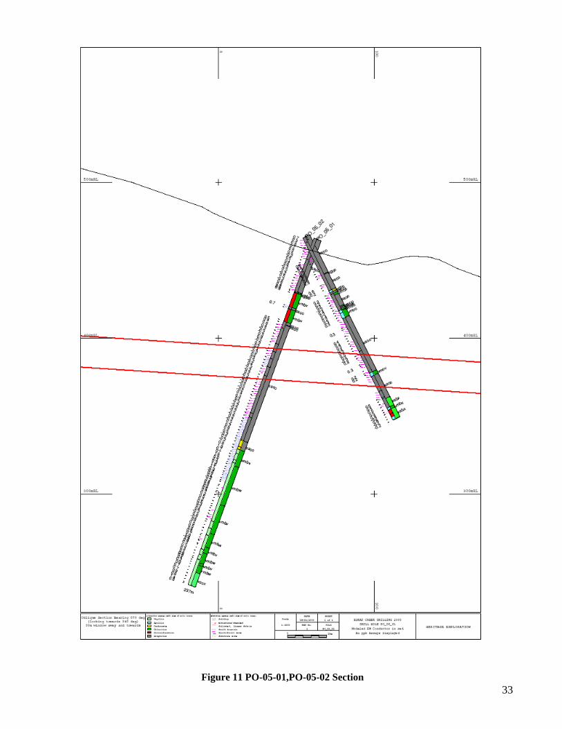
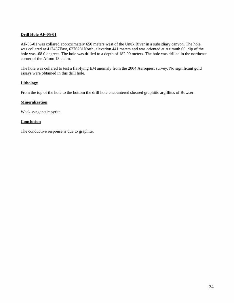
Drill Hole AF-05-01 AF-05-01 was collared approximately 650 meters west of the Unuk River in a subsidiary canyon. The hole was collared at 412437East, 6276231North, elevation 441 meters and was oriented at Azimuth 60, dip of the hole was -68.0 degrees. The hole was drilled to a depth of 182.90 meters. The hole was drilled in the northeast corner of the Aftom 18 claim. The hole was collared to test a flat-lying EM anomaly from the 2004 Aeroquest survey. No significant gold assays were obtained in this drill hole. Lithology From the top of the hole to the bottom the drill hole encountered sheared graphitic argillites of Bowser. Mineralization Weak syngenetic pyrite. Conclusion The conductive response is due to graphite.
Figure 12 AF-05-01 Section
35
36
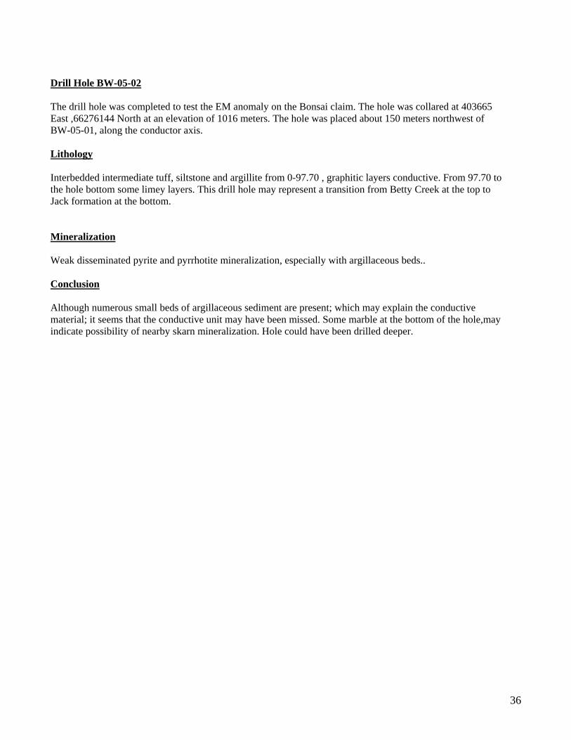
Drill Hole BW-05-02 The drill hole was completed to test the EM anomaly on the Bonsai claim. The hole was collared at 403665 East ,66276144 North at an elevation of 1016 meters. The hole was placed about 150 meters northwest of BW-05-01, along the conductor axis. Lithology Interbedded intermediate tuff, siltstone and argillite from 0-97.70 , graphitic layers conductive. From 97.70 to the hole bottom some limey layers. This drill hole may represent a transition from Betty Creek at the top to Jack formation at the bottom. Mineralization Weak disseminated pyrite and pyrrhotite mineralization, especially with argillaceous beds.. Conclusion Although numerous small beds of argillaceous sediment are present; which may explain the conductive material; it seems that the conductive unit may have been missed. Some marble at the bottom of the hole,may indicate possibility of nearby skarn mineralization. Hole could have been drilled deeper.
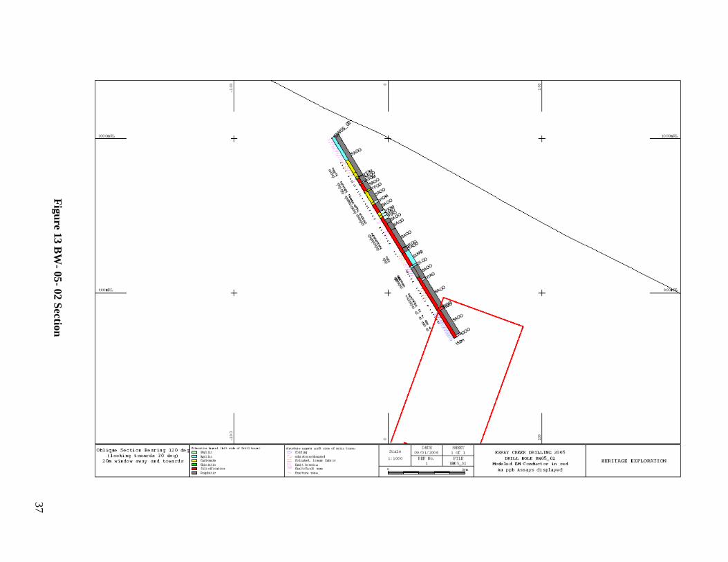
Figure 13 BW
- 05- 02 Section
37
38
Drill holes BZ05-11,12 Two drill holes were drilled off the same setup at 404895 East; 6276482 N with identical azimuth, BZ05-11 was drilled at Azimuth 224 and -49 degrees to a depth of 151.5 meters, BZ05-12 was drilled at -80 dip to a to a depth of 111.1 meters. The holes were completed on the Bonsai 3 claim. Lithologies intersected are thought to represent Salmon River rhyolite and interflow sediments. A section parallel to both holes is given on the next page Figure 14. No significant gold values were found in the two holes. Lithology BZ05-11 encountered interbedded , graphitic,argillaceous mudstones and massive and autoclastic rhyolite.rhyolite through its entire length. Minor diorite was intercepted from 22-30 meters. BZ05-12 encountered similar lithologies to BZ05-11. Mineralization Trace – 2% pyrite was encountered scattered throughout both holes. Rhyolite intervals are very siliceous. Conclusion Could not find extensions to mineralization encountered in 2003 and 2004.
Figure 14 BZ
05-11,12 Section
39
40
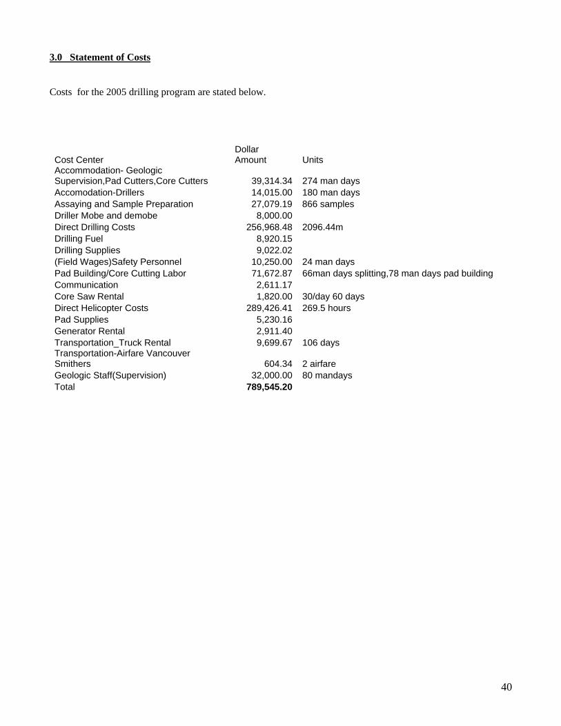
3.0 Statement of Costs Costs for the 2005 drilling program are stated below.
Cost Center Dollar Amount Units
Accommodation- Geologic Supervision,Pad Cutters,Core Cutters 39,314.34 274 man days Accomodation-Drillers 14,015.00 180 man days Assaying and Sample Preparation 27,079.19 866 samples Driller Mobe and demobe 8,000.00 Direct Drilling Costs 256,968.48 2096.44m Drilling Fuel 8,920.15 Drilling Supplies 9,022.02 (Field Wages)Safety Personnel 10,250.00 24 man days Pad Building/Core Cutting Labor 71,672.87 66man days splitting,78 man days pad building Communication 2,611.17 Core Saw Rental 1,820.00 30/day 60 days Direct Helicopter Costs 289,426.41 269.5 hours Pad Supplies 5,230.16 Generator Rental 2,911.40 Transportation_Truck Rental 9,699.67 106 days Transportation-Airfare Vancouver Smithers 604.34 2 airfare Geologic Staff(Supervision) 32,000.00 80 mandays Total 789,545.20

41
4.0 Statement of Qualifications
STATEMENT OF QUALIFICATIONS
I Warren Bates, Bsc.(Hons) P.Geo, of 128 Sparling Court, Oakville, Ontario, Canada, do hereby certify the following:
- I am a geologist employed by St.Andrew Goldfields
- I have been practicing my profession continuously since graduation in 1985, as a geologist in Canada, the United States of America, Venezuela, Chile, Peru, Ecuador, Bolivia, Mexico and Indonesia.
- I am a graduate of the University of Manitoba, with a Bachelor of Science (Hons.) degree in geology in 1985.
- I am a member of the Association of Professional Geologists of Ontario (APGO).
- I have not, directly or indirectly, received or expect to receive, any interests in the properties of Heritage Explorations Ltd. I have no direct or indirect ownership or option on securities of Heritage, nor do I expect to receive any such securities in the future.
Signed Warren Bates
42
STATEMENT OF QUALIFICATIONS Antony W. Worth, Bsc I Tony Worth, Bsc., of 39 Godwin Avenue, Manning (Perth), Western Australia, do hereby certify the following:
- I am a geologist employed by Geoinformatics Exploration Australia Ltd.
- I have been practicing my profession continuously since graduation in 1992, as a geologist in Australia, Africa and Canada.
- I am a graduate of the University of Western Australia, with a Bachelor of Science degree in geology in 1992.
- I am a member of the Australasian Institute of Mining and Metallurgy (AusIMM).
- I have not, directly or indirectly, received or expect to receive, any interests in the properties of Heritage Explorations Ltd. I have no direct or indirect ownership or option on securities of Heritage, nor do I expect to receive any such securities in the future.
43
STATEMENT OF QUALIFICATIONS
Bill Burnett, M.Sc I Bill Burnett, M.Sc, of , do hereby certify the following:
- I am a geologist employed by Mystery Creek Resources Ltd.
- I have been practicing my profession continuously since graduation in (year), as a geologist in the United States and Canada.
- I am a graduate of the University of , with a Bachelor of Science degree in Geology in (year),and the University of ,with a Masters of Science in Geology.
- I am a member of the .
- I have not, directly or indirectly, received or expect to receive, any interests in the properties of Heritage Explorations Ltd. I have no direct or indirect ownership or option on securities of Heritage, nor do I expect to receive any such securities in the future.
44
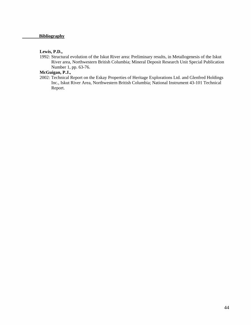
Bibliography
Lewis, P.D., 1992: Structural evolution of the Iskut River area: Preliminary results, in Metallogenesis of the Iskut
River area, Northwestern British Columbia; Mineral Deposit Research Unit Special Publication Number 1, pp. 63-76.
McGuigan, P.J., 2002: Technical Report on the Eskay Properties of Heritage Explorations Ltd. and Glenfred Holdings
Inc., Iskut River Area, Northwestern British Columbia; National Instrument 43-101 Technical Report.