Embed Size (px)
Citation preview

Ursa Major Minerals In,~orporated.
100% Owned Shakespeare Project Property
Shakespeare and Dunlop Townships, Ontario
Sudbury Mining Division
MND&M's, Plan G-3001 &. G-3002
8834
Sutherland Creek Area Diamond Drilling Program
An Attempt to Test a Geophysical Response Which May Correspond with the Potential Trace of the Shakespeare Stratigraphy on the North Limb of the Porter Lake
Synclinorium, West Along Strike From the Shakespeare West Mineral Deposit.
January and February of2006
Project U-03
By:
Harold J. Tracanelli; GETN. P.Geo
June 25 th .,2008

Manitoba
Poe:k1e La"" •
Hudson Bay
IIod lake
• ONTARIO Quebec
"
~. •
U.S.A.
t , '00" :,
Geraldlon
•
• ... .. .....
7dnn~-.ns
• • K"kland lake
Toronto •
• Ottawa
Lau OnIaoo
URSA. Major Minerals Inc. Shakespeare Property
Figure 1: URSA Major Minerals Incorporated - Sutherland Creek Diamond Drilling Program Report, Project Area Location Map
2

TABLE OF CONTENTS
The following information is a categorization of the various components, tables, figures, photographs and drawings provided within this URSA Major Minerals Incorporated, Report on the Diamond Drilling Program, carried out during May and June of 2007, on the Sutherland Creek Property, located north of Agnew Lake and west of the Sudbury Basin in the province of Ontario.
1.0 Introduction ................................................................... . 6
2.0 Property Location and Access ............................................. ,. 6
3.0 Mining Property and Current Access 8
4.0 Physiography and Climate .................................................. . 9
5.0 Vegetation and Wildlife ................................... , ................. . 11
6.0 Exploration History ................................................... . 12
7.0 Regional and Local Geology of the Shakespeare Project Property ................................................ ~ 17-18
8.0 Regional Geology ........................................................... . 18
9.0 Local Geology ................................................................. -19--20
10.00 Brief Geology and Sulphide Mineralization of the Shakespeare Suite-Intrusive Stratigraphy ........................................... , ....................... -20--23
11.0 Standard Lithological Coding .............................................. -23- 24
12.00 Standard Sulphide Coding ..... '" ...................................... , '" 24
13.0 Exploration Work Performed .................................... - 26
14.0 Discussions and Results of the Diamond Drill Program 34
15.0 Conclusions ................................................................. - 41
16.0 Recommendations ......................................................... , 42
17.0 Certificate of Qualifications... .. ......... ...... ......... ..... ........ .... 43
3
Harold J. Tracanelli GETN, P. GEO, 1156
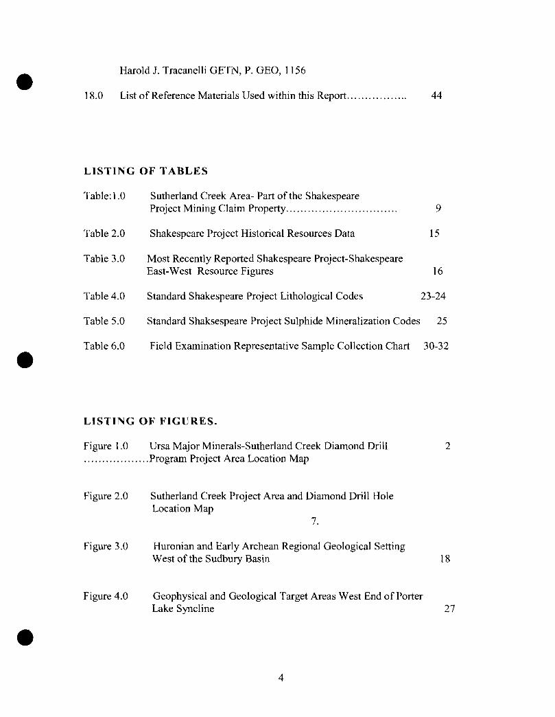
18.0 List of Reference Materials Used within this Report... ...... ........ 44
LISTING OF TABLES
Table: 1.0 Sutherland Creek Area- Part of the Shakespeare Project Mining Claim Property............................... 9
Table 2.0 Shakespeare Project Historical Resources Data 15
Table 3.0 Most Recently Reported Shakespeare Project-Shakespeare East-West Resource Figures 16
Table 4.0 Standard Shakespeare Project Lithological Codes 23-24
Table 5.0 Standard Shaksespeare Project Sulphide Mineralization Codes 25
Table 6.0 Field Examination Representative Sample Collection Chart 30-32
LISTING OF FIGURES.
Figure 1.0 Ursa Major Minerals-Sutherland Creek Diamond Drill 2 .................. Program Project Area Location Map
Figure 2.0
Figure 3.0
Figure 4.0
Sutherland Creek Project Area and Diamond Drill Hole Location Map
7.
Huronian and Early Archean Regional Geological Setting West of the Sudbury Basin 18
Geophysical and Geological Target Areas West End of Porter Lake Syncline 27
4

Figure 5.0 Representative Sample Locations 33
LISTING OF PHOTOGRAPHS.
Photograph 1.0 View Facing East toward the North Shore of Agnew Lake to
Photograph 2.0 Site of Diamond Drill Hole U-03-86 38
Photograph 3.0 Facing South at the Narrows of Sutherland Creek
Photograph 4.0 View Northwards up Sutherland Creek Bay
Photograph 5.0 Facing Southward along Long Axis of Outcrop Exposure of The Nipissing Gabbro Rocks
5
39
40
41
Introduction
The URSA Major Minerals Incorporated., Sutherland Creek Area ofthe Shakespeare Project Property, is located near the north eastern areas of Shakespeare and south eastern portion of Dunlop Township, in the Provincial geographical District of Sudbury, Sudbury Mining Division in Ontario.
The Sutherland Creek Area portion of the mining claim property consists of 5 claims totaling approximately 38 units essentially situated over the mainly south facing Precambrian Huronian sedimentary rocks of the north limb of the Porter Lake Synclinorium, located west - north west along strike from the Shakespeare West mineral deposit. The Sutherland Creek diamond drilling program was essentially carried out in the south east comer of mining claim S-3016237 in south eastern Dunlop Township, and the north east comer of mining claim S-3016239. The primary objective of the diamond drill program was to attempt to test a Crone Geophysics TDEM geophysical which may correspond with the potential trace of the Shakespeare stratigraphy.
The surface TDEM geophysical anomaly as reported by Crone Geophysics is located a short distance to the west of the shore of Sutherland Creek Bay on Agnew Lake. The area is characteristically covered with unconsolidated glacial debris of sand, gravel and silt / clay like materials. To the west and northwest of the target areas there are a number of protruding outcroppings of traditional Nipissing sill gabbros and basil Nipissing pyroxenitic rocks, that in the area are thought to occur below the potentially north facing Shakespeare Intrusion stratigraphy.
In an attempt to explore and explain the cause of the geophysical response detected, two opposing, fairly shallow diamond drill holes were attempted to be put down towards the target, but were faced with extreme difficulties and came up short of the objective due to the aggressive and constricting nature of the overburden materials.
Unfortunately due to the nature of the overburden materials, the inclined diamond drill holes U-03-85 and U-03-86 were not able to penetrate the overburden materials. Efforts were undertaken between February 04th
., 2006 and February 16th., 2006, at which time a
total length of 263 meters ofNQ casing were sunk for the two diamond drill holes in an attempt to reach the target. Despite valiant efforts by the drilling company, they were not successful in reaching the sub crop. As a result of these failed efforts it has not yet been possible to explain the cause ofthe geophysical anomaly. Once a decision was made to abandon the drilling attempts, all ofthe NQ casing and the casing shoes were aU recovered for reuse.
Owing that it has not been possible to explain the geophysical anomaly, careful considerations should be given to initiating further exploration efforts to make a second attempt at exploration of the anomaly. Owing that it proved not to be possible to reach the sub crop target by sinking a flush casing with two inclined diamond drill holes, if future attempts were to be made, consideration should be given to attempting to reach the target by sinking flush casing vertically.
6

As such as an initial recommendation, it should be possible to make a second attempt to test the geophysical anomaly by putting down a vertical diamond drill hole above the anomaly to an estimated depth of approximately 300 meters.
The all inclusive cost to carry out such a program has been estimated to be in the order of $40,000.00 +/-.
2.0 PROPERTY LOCATION AND ACCESS
The following is a depiction as to the limits of the Sutherland Creek Area of the Shakespeare Project Property which is located in Shakespeare and Dunlop Township, Sudbury Mining Division, Ontario.
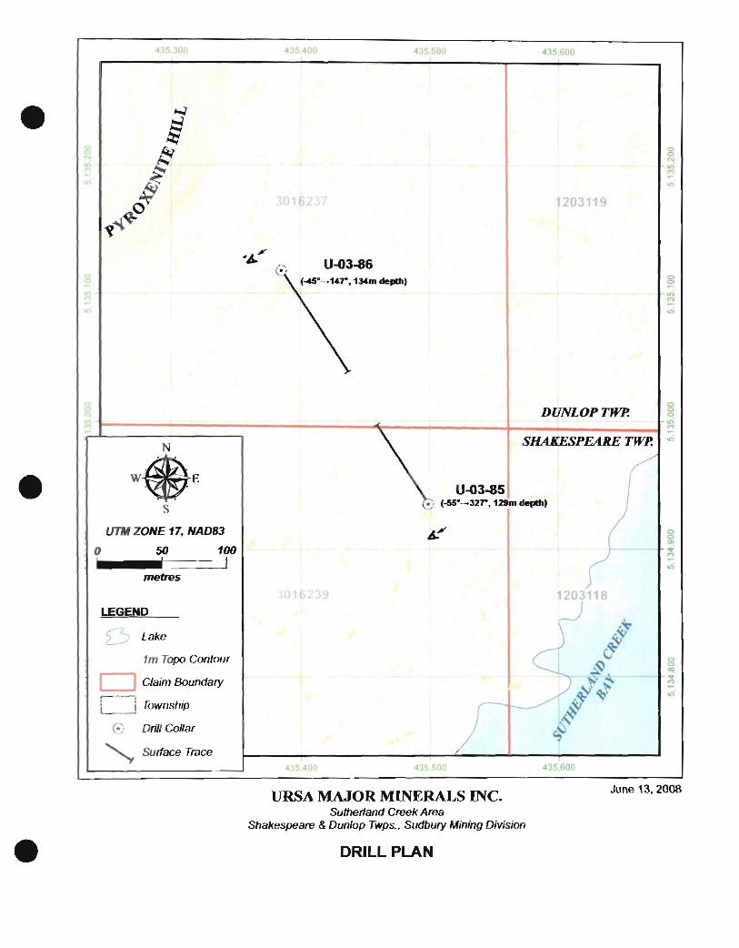
UlWZ-U ...... Figure: 2 Sutherland Creek Project Area and Diamond Drill Hole Location Map
The Ursa Major Minerals Inc., 100% owned Shakespeare Project Property, is located approximately 75 kms west and lOkm north of the Trans Canada Highway 17, from the Greater City of Sudbury, Ontario. The project is located with an easy 5 Yz to 6 hour drive from the City of Toronto.
7
Access to the property and the Sutherland Creek Project area can be afforded from two directions, mainly by traveling approximately 10 kms to the north of Webbwood, Ontario, via the Agnew Lake Road, on to the Agnew Lake Lodge. The project area can easily be reached by at a 10 minute boat trip north of the Agnew Lake Lodge. The project area can also be reached via a network or former forestry roads and ATV trails by traveling west past the existing Shakespeare Nickel Project Road.
Presently the preferred access onto the Shakespeare Property is via a network of former logging roads leading northwest from the small town of Nairn Centre, connecting up with the recently upgraded 7 km long Shakespeare Access Road, which leads directly to the Shakespeare West mineral deposit area. An access road terminates on mining claim S-35594.
By virtue of a current agreement with the Ministry of Natural Resources, and through the Public Lands Act, at the road entrance a chained and securely locked gate has been erected and the appropriate signage has been secured. From the perspective of ensuring that the health and safety of the of the public is not being jeopardized, access onto the Shakespeare Project Access road is strictly controlled and monitored on a regular basis and prior authorization from the local Espanola branch of the MNR, and Ursa Major Minerals Inc., must be obtained before any access might be permitted. Enforcement of the various rules and regulations for controlling access onto public lands is governed by the MNR through the Public Lands Act.
3.0 MINING PROPERTY and CURRENT STATUS
The URSA Major Minerals Incorporated., Sutherland Creek Area portion of the Shakespeare Project Property, is presently in good standing, and more or less straddles the east- west boundary which separates Shakespeare and Dunlop Townships. The mining claims and Townships are all located within the provincial geographical jurisdiction of the District of Sudbury, Sudbury Mining Division, Ontario.
What has been identified as the Sutherland Creek Area of the Shakespeare Property includes three contiguous staked mining claims numbered S-3016237, S-3016238, and S-3016239, in Shakespeare and Dunlop Townships which is also contiguous with two recently leased mining claims numbered S-1203118 and S-1203119 also located in Shakespeare and Dunlop Townships.
8

The property consists of38 mining claim units covering an estimated 1520 acres or 608 Hectares in the Townships of Shakespeare and Dunlop.
Ursa Major Minerals Incorporated
Sutherland Creek Area of the Shakespeare Project Property
Township Status Unit Acres Claim # Dunlop Staked 7 280 S-3016237 Shakespeare Staked 10 400 S-3016238 Shakespeare Staked 6 240 S-31 06239 Shakespeare Leased 8 320 S-1203118 Dunlop Leased 7 280 S-1203119 Total: 38 1520 5
Table: 1 Sutherland Creek Area- Part of the Shakespeare Project Mining Claim Property
1 claim unit is nominally 40 acres or 16 hectares
Please note that the Sutherland Creek Diamond Drilling Program drill holes were put down on mining claims: S-3016237 and S-3016239. The diamond drilling work was carried out very near the geographic center of the project area.
4.0 PHYSIOGRAPHY and CLIMATE
The general geographical region occurs within the limits of the Great Lakes Basin near the rugged north shore of Georgian Bay. It represents the northern limits of the Great Lake Forest region, and is approximately 50km's (30 miles) from the western edge of Sudbury Basin area.
A large drainage basin area has been developed allowing drainage towards the Spanish River which ultimately drains into Georgian Bay towards the south. It has been suggested that the Spanish River may have existed during pre- Wisconsin glacial times and may have been part of a very old pre- existing river system.
Agnew Lake, which was once part of the original Spanish River channel was dammed up by the International Nickel Company of Canada (INCO) in the late 1900's in order to generate hydro electric power for their Copper Cliff smelting operations. The damming of the river resulted in the development of Agnew Lake which is in the order of32 km's (20 miles +1-) in length.
The northeastern and northwestern areas of Shakespeare and Baldwin Townships are noted for there rugged terrain, well marked by a series of northeasterly trending deep gullies and ridges, a quite distinct forming saw toothed topography. Within the property area the topography can be defined as somewhat rolling hills, marked by several well exposed open craggy areas with abrupt scarp - cliff like features, influenced by the resistive nature of the surrounding geology, structures and erosion that occurred in the area. The erosion characteristics of the area are governed in part by the surround geology, which is made up of
9
predominantly highly resistant, fme to course grained, quartz rich sedimentary rocks which were then intruded by younger massive sills and or dyke like features of less resistive gabbroic rocks. This assemblage of rocks were then subjected to assorted epochs of local and regional deformation to include the Penokian Orogeny, which in part resulted in the strongly developed deformation and folding to occur in the area. Large scaled faulting associated with the Murray Fault system - zones, such as the Hunter Lake, Cameron Creek and Fairbanks Lake faults to name a few, were ultimately responsible for further dissecting and over thrusting some of the surrounding geology, which has allowed distinct ridges to fonn as a result of deep erosion occurring along these parallel structural zones.
The surrounding hills in the area are generally well vegetated, with an abundance of tree and animal species, with distinct habitats being observed in gullies and on ridges. The area has been very well glaciated, forming local crag and tail formations with large exposures of geology and boulder piles. Some glacial - divergent river channels are evident, most notably along Stumpy Bay through to the Long Bay area where fine grain sand and silt materials running off from the surrounding hillsides have been visibly cut by the flowing waters. For the most part many of the gully and valley areas have been deeply eroded with some remnant sands, silts and clay like materials having been deposited. Some of these areas were then overgrown and have since developed into wet, poorly drained swampy terrains. Locally, glacial striations have been observed which would appear to indicate ice direction of north and northeast.
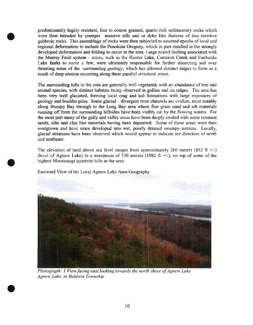
The elevation of land above sea level ranges from approximately 260 meters (852 ft +/-) (level of Agnew Lake) to a maximum of 330 meters 0082 ft +1-), on top of some of the highest Mississaugi quartzite hills in the area.
Eastward View of the Local Agnew Lake Area Geography
Photograph: 1 View facing east looking towards the north shore of Agnew Lake Agnew Lake, in Baldwin Township
10
The seasonal weather patterns that can be observed within the area are typical of the weather patterns known to occur within the Great Lakes Forest of the Georgian Bay region which extends towards the southern limits of the Boreal Forest located only a short distance towards the north.
Winters are typically cold, often with temperatures in the -30 to -40 degree C., range, while it is not uncommon for summer temperatures to reach as high as -+30 or +-35 degrees C The area is known to be notoriously windy, occasionally very strong north winds appear to funnel down the length of the Spanish River valley area and pour out into the area near the west end of Agnew Lake ..
5.0 VEGETATION AND WILDLIFE
The surrounding areas around Agnew Lake are generally well vegetated with a wide variety of second or third growth tree species, which in many places still show some of the remnants of once larger timbered areas which were once dominated by large, towering white and red pine trees. Beginning well over 100 years ago, several companies in the area were involved in large scaled logging operations involving the harvesting of the big pines. Such logging operations were carried out extensively along the shores, and spreading inland from the course of the Spanish River, while using the river as a means of transporting the raw logs to the various saw mills and transportation facilities located downstream. Subsequent to some of these logging operations, the area was frequently subjected to forest fires, with the scars and remnants of such events still being evident to this day. Scattered evidence of the former logging operations can still be seen, as remnants of old campsites, chains and pins in outcroppings, old horse haulage roads that had once been carved through the bush are still evident in many places throughout the surrounding countryside.
The area may be best characterized as being made up of a wide variety of "mixed bush", of that being more or less within a the "transitional zone" between the Boreal Forest to the north and the Great Lakes Forest to the south.
A list of commonly occurring species of wildlife in the general region includes:
White and Trembling Aspen Poplar White Paper Birch, YeHow Birch Black Spruce with the occasional White Spruce Red and White Pine Eastern White Cedar Hemlock, located on the north sides of hills and shaded gullies Sugar, Mountain Maple, Striped Maple Balsam Fir Some larger sized Oak and Oak scrub brush on top of hills Black, Swamp and Mountain Ash in some swamps American Hop Hornbeam, Jack Pine and Tamarack, are occasionally seen Wide variety of Willow, Speckled Alder, Mountain Holly and assorted brush Juniper Beaked Hazel Nut
11
Wild life in the area can be periodically abundant and can include:
White Tailed Deer Moose, less common than deer Black Bear Timber Wolf Mink Martin Muskrat Lynx Red Fox Beaver
6.0 EXPLORATION HISTORY
It is not the intension within the scope of this report to describe in great detail the extensive nature of the exploration history of the area of interest. As such, it is advisable that if more detailed infonnation is being sought, the reader should refer to the extensive collection of assessment files for the Shakespeare, and the adjacent townships of Baldwin, Porter and Hyman areas found at the Ministry of Northern Development and Mines, Resident Geologists Office, located in Sudbury, Ontario.
It would appear that in general the Sutherland Creek area may have received relatively little or no major exploration efforts over the years. Much of the area is covered with locally thick glacial debris with little or no evidence on the ground that would suggest any extensive activities.
It certainly can be said that over the many years of local history, the extensive Spanish River drainage basin and its many tributaries would have offered easy access so as to allow trappers, fur traders, loggers, hunters, fishennen, settlers and prospectors alike to travel quite far inland.
It is highly conceivable that some of these areas were examined for the mineral potential as for example where rusty, or unusual looking rock fonnations such as veining may have been seen. Such occurrences would have most certainly attracted those seeking valuable minerals. Unfortunately in many of the areas there is very little direct visible - physical evidence or documentation that might indicate such efforts ever took place.
Most certainly in the area of the well exposed and highly gossanous exposure at the Shakespeare West mineral deposit, prospectors and the like would have been very quick to pick up on such areas. Unfortunately in close proximity to the Shakespeare West deposit there is the very thick cover of the Mississaugi fonnation quartzite's, which would have quickly discouraged traditional prospecting efforts.
Despite the apparent traffic that one would have expected along the Spanish River corridor, reports have it that it was not until sometime during the 1920's that the original Shakespeare sulphide showings were explored by the Sudbury Shakespeare Gold Copper Syndicate.
12
Atthat time the company was said to have carried out some limited trenching. Judging by the actual size of the original Shakespeare occurrence and the West Shakespeare deposit area, it is quite remarkable just how little surface trenching was carried out. In 1941, Frobisher Exploration staked the property and over the next several years carried out a plane table survey, geological mapping and diamond drilling in the area of the Shakespeare West deposit. Three diamond drill holes were completed in 1942 and another 15 in 1948. Limited metallurgical test work was also carried out in 1941 by Falconbridge Nickel Mines Limited, at which time it was reported that the testing efforts gave favorable results.
In 1947, Falconbridge acquired the claims from Frobisher Exploration, and between 1949 and 1953 Falconbridge completed geological mapping, magnetometer and radiometric surveys, diamond drilling and resource estimation work. Diamond drilling consisted of putting down 12 drill holes totaling some 1,829 meters. These efforts were principally designed to more thoroughly explore and to provide more detailed information with respect to the Shakespeare West mineral deposit. At the time the company explored the mineral deposit down to a depth of about 75 meters vertically.
By 1951 the company had explored the mineral resources down to a depth of about 152 meters (498.56 feet) and to much shallower depths of not more than 30 meters (98.4 feet). The resource estimation calculated to the depth scenario of 152 meters (498.56 feet) proposed extraction by means of both open pit and underground mining methods. Such methods took into consideration that there would be a considerable amount of waste: stripping required to get at the ore materials. Results of this estimation indicated a non 1-43-101 compliant total of 3,273,000 short tons grading 0.34% Ni and 0.40% Cu.
The Non 1-43-101 compliant resource estimation to the conservative depth of30 meters (98.4 feet) depth assumed mining would be done exclusively by means of open pit with steep sided pit walls slopes of80 degrees. Results ofthis work indicated a total of 1,255,000 short tons grading 0.33% Ni and 0.37% Cu. The 1951 estimates included mineralization located between Line 2000 Wand 800 W. The resource evaluation determinations were based on a series of cross-sections and a long section. The long section through the mineral deposit indicates relatively consistent ranges for grade. A few of the drill hole intercepts seemed to be abnormally narrow with some lower grades which appear to correspond to holes which may have passed under the zone.
1 long hiatus of inactivity ensued on the property, and it was not until 1974 when a series of new resource estimates and engineering studies were completed. During this reactivation of efforts, two resource estimates were completed. The fIrst defIned a tonnage available for open pit mining, at a 1: 1 stripping ratio with 60° pit wall slopes, totaling 2,869,000 short tons at grades of 0.33% Ni and 0.36% Cu to a depth of 58 meters (190.24 feet).
The second resource, applying open pit extraction with a stripping ratio 0[0.5:1, totaled 2,195,000 short tons, grading 0.33% Ni and 0.36% Cu.
The engineering study involved a preliminary review of the feasibility for mining the shallow depth resources. The study envisaged mining by open pit methods, barging of ore across Agnew Lake and trucking of ore to a Falconbridge mill approximately 65 miles (40.65 kilometers) away. Unfortunately the results of the study efforts were shown to be negative.
13
With improved metal prices in 1985, Falconbridge once again became interested in exploring the area. As such the company completed further diamond drilling and carried out a new round of resource estimations in conjunction with a number of economic and metallurgical studies to further evaluate the Shakespeare West mineral deposit. The diamond drill program included putting down 16 holes and was essentially designed to intersect the near surface exposures and interpreted expression of the Shakespeare deposit on nominally 30.5 meter (100.00 foot) centers. Most of the drill holes were collared between the grid lines of 200W and 2000W and intersected the zone at depths ofless than 76 meters (249.28 feet) vertically below the surface.
The 1985 resource estimate by Falconbridge included materials between grid lines 500W and 2000Was such the results of these efforts indicated a total resource of2,081,373 short tons, grading 0.36% Ni, 0.42% Cu, 0.22 glt Au, 0.40 glt Pt and 0.46 glt Pd.
A second resource estimate totaling 1,106,703 short tons, grading 0.37% Ni, 0.40% Cu, 0.23 glt Au, 0.41 glt Pt and 0.45 glt Pd to a depth of 30 meters (98.40 feet) was also carried out during that time. In 1985, the company also initiated mineralogical and metallurgical tests which were conducted by both Falconbridge and Lakefield Research, (a division of Falconbridge) which returned results which were considered reasonable, but less favorable than the 1941 tests.
Following the 1985 exploration efforts, the company initiated further engineering studies which were carried out by L.T. Dunks ofL.T. Dunks and Associates and D.M. Smith, of Fa1conbridge. The efforts were to take into consideration a similar mining plan to that which was proposed back in the 1974 study, but incorporating results from the new 1985 metallurgical work. Unfortunately these engineering study efforts also produced negative results.
In 1986, Falconbridge, was again out on the property and completed an additiona14 diamond drill holes, totaling 1,617 m and again an engineering study was carried out. All 4 holes were drilled west of Line 1800W. As such these drill holes were principally designed to test for extensions of the deposit to depths greater than 152 meters (498.56 feet) vertically below the surface. The engineering study was carried out by Walter Thompson and Associates using a similar mining plan to that which was used during the 1985 study. For the 1986 study hauling the ore to the Falconbridge mill on a new road constructed along the north side of Agnew Lake would be factored into the study, which not unlike like the previous studies also returned negative results. It was commonly concluded that profitability may be possible if the deposit were slightly larger and higher in grade in conjunction with higher metal prices and an established truck haulage route. During that time it was not possible to meet the demands of the various parameters and the Shakespeare West mineral deposit I advance prospect was sufficiently remote enough and admittedly difficult to reach, effectively discouraging any further efforts.
Historical mineral resource estimates for the Shakespeare Property as presented in this section are summarized in the table below:
None of these resource estimates that have been reported were found to be compliant with National Instrument 43-101.
14

No further work was perfonned on the property until 2000, when the property was acquired by URSA Major Minerals Incorporated, through a "Joint Venture" agreement with Falconbridge Ltd. Early work carried out by URSA back in 2000 and 2001 had involved digital compilation, geological mapping, sampling, and some limited geophysical surveys. From 2002 through to the present Ursa Major Minerals Inc. has carried out an extensive amount of diamond drilling on the Shakespeare property. In June of 2003 the company discovered the Shakespeare East mineral deposit. From then on, the company carried out an extensive amount of exploration work which included additional ground and bore hole geophysics, surface trenching, geotechnical mapping probing, feasibility and base line environmental studies, public consultations and successful pennitting. To date Ursa Major Minerals Inc., has completed on the Shakespeare East and the Shakespeare West Minerals deposit areas, a total of96 diamond drill holes accounting for 17,572.78 meters (57,638.72 feet) of diamond drilling and to directly explore the deposit areas, from May 22nd
., 2002 to December 06th., 2007.
The historical Ursa Major Minerals Inc., Shakespeare Project diamond drilling so far as those efforts completed in the Shakespeare West and Shakespeare mineral deposit areas include:
DDH's., U-03-03 to U-03-46 DDH's., U-03-48 to U-03-55 DDH's., U-03-59 to U-03-84 DDH's U-03-91 to U-03-97 DDH's U-03-99 to U-03-111
= 8,205.76 meters = 2,214.77 meters = 5,775.00 meters = 386.25 meters = 957.10 meters = 17,538.88 meters
(26,914.89 feet) (7,264.45 feet) (18,942 feet) (1,266.9 feet) (3,250.48 feet (57,527.53 feet)
Pre URSA Major Minerals Incorporated, resources evaluations and reported deposit size and grade estimations were once carried out by Lochhead, Penstone, for Falconbridge Ltd., have been presented below:
Historical Resource Estimations Historical Depth Type Tonnage Ni eu Au Pt Resource (feet) (%) (%) (glt) (glt) Estimates for the Shakespeare Deposit. Date Lochhead 500 Maximum 3,273,000 0.34 OAO (1951 )
100 Minimum 1,255,000 0.33 0.37 Penstone 190 2,869,000 0.33 0.36 (1974)
2,195,000 0.33 0.36
F alconbridge Global 2,081,373 0.36 OA2 0.22 OAO (1985)
100 Open Pit 1,106,000 0.37 OAO 0.23 OA1
Table: 2 Shakespeare Project Historical Resources Data
15
Pd (g/t)
OA6
OA5
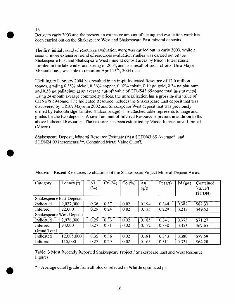
18 Between early 2003 and the present an extensive amount of testing and evaluation work has been carried out on the Shakespeare West and Shakespeare East mineral deposits.
The first initial round of resources evaluation work was carried out in eady 2003, while a second more extensive round of resources evaluation studies was carried out on the Shakespeare East and Shakespeare West mineral deposit areas by Micon International Limited in the late winter and spring of 2004, and as a result of such efforts Ursa Major Minerals Inc .. ; was able to report on April 15th
., 2004 that:
"Drilling to February 2004 has resulted in an in-pit Indicated Resource of 12.0 million tonnes, grading 0.35% nickel, 0.36% copper, 0.02% cobalt, 0.19 glt gold, 0.34 glt platinum and 0.38 glt palladium at an average cut-off value ofCDN$43.65/tonne total in-situ metal. Using 24-month average commodity prices, the mineralization has a gross in-situ value of CDN$79.59/tonne. The Indicated Resource includes the Shakespeare East deposit that was discovered by URSA Major in 2002 and Shakespeare West deposit that was previously drilled by Falconbridge Limited (Falconbridge). The attached table represents tonnage and grades for the two deposits. A small amount ofInferred Resource is present in addition to the above Indicated Resource. The resource has been estimated by Micon International Limited (Micon).
Shakespeare Deposit, Mineral Resource Estimate (At a $CDN43.65 Average*, and $CDN24.09 Incremental**, Contained Metal Value Cutoff)
Modern Recent Resources Evaluations of the Shakespeare Project Mineral Deposit Areas.
Category Tonnes (t)
Grand Total Indicated 12,005,000 Inferred 115,000
Ni Cu (%) Co (%) Au (%) (g/t)
Pt (g/t) Pd (g/t) Contained Valuelt ($CDN)
$82.33 $49.52
$71.27 $67.65
$79.59 $64.20
Table: 3 Most Recently Reported Shakespeare Project I Shakespeare East and West Resource Figures.
* - Average cutoff grade from all blocks selected in Whittle optimized pit
16

** - Marginal cutoff grade at the pit rim, which only has costs applied for haulage, G&A and process mg.
The mineral resource estimate is based on the following assumptions. The resources will be mined by open pit methods at estimated rates of between 4,500 and 5,000 tonnes / day, milled at existing facilities and an estimated 66% of the contained metal value will be payable after concentrator losses and smelter charges.
The resources were reported from a block model with Gemcom software and a pit shell optimized with Whittle 4X software using a $CDNl.75/tonne mining cost, 45° pit slope, $CDN1 0.50/tonne processing cost, $CDNl.OO/tonne G&A and a $CDN4.40/tonne road haulage cost ($0.08/tonne-kilometre). No external dilution has been applied to these calculations.
Contained metal values were calculated using 24-month-average commodity prices (nickel $US4.211Ib, copper $USO.82/lb, cobalt SUS 1 0.48/lb, gold $US351.43/0z, platinum $US635.40/oz and palladium $US300.31/0z) and an I8-month-average Canadian dollar exchange rate ofO. 7067."
The Shakespeare Nickel Project is presently in the pre-production mining stages of advanced exploration - testing and mineral resources evaluation efforts.
Most recently, reports have the Shakespeare deposit containing an open-pit, diluted, Probable Reserve of 11,226,000 tonnes grading 0.33% nickel, 0.35% copper, 0.02% cobalt, and 0.9 glt precious metals.
Presently there has been no decision or official announcement with respect to commercial production from the Shakespeare mineral deposits although URSA Major Minerals Incorporated is an emerging mining company that is focused on grO\vth through nickel, copper, and precious metal development and exploration opportunities primarily in Ontario, Canada.
7.0 REGIONAL and LOCAL GEOLOGY of the SHAKESPEARE PROJECT PROPERTY
In part, much of the following sections on the geological setting presented in this report, including past exploration and resource estimates, have been derived from information presented originally in a report prepared by: Eric A. Kallio, P.Geo., entitled "Technical Report for the Shakespeare Property, Shakespeare Township, Ontario, NTS 41115 for URSA Major Minerals Incorporated" and dated November 28, 2002. Kallio's report is incorporated by reference into Micon's prior Technical Reports.
17
II II J
11 J 11 00. 00
N
o
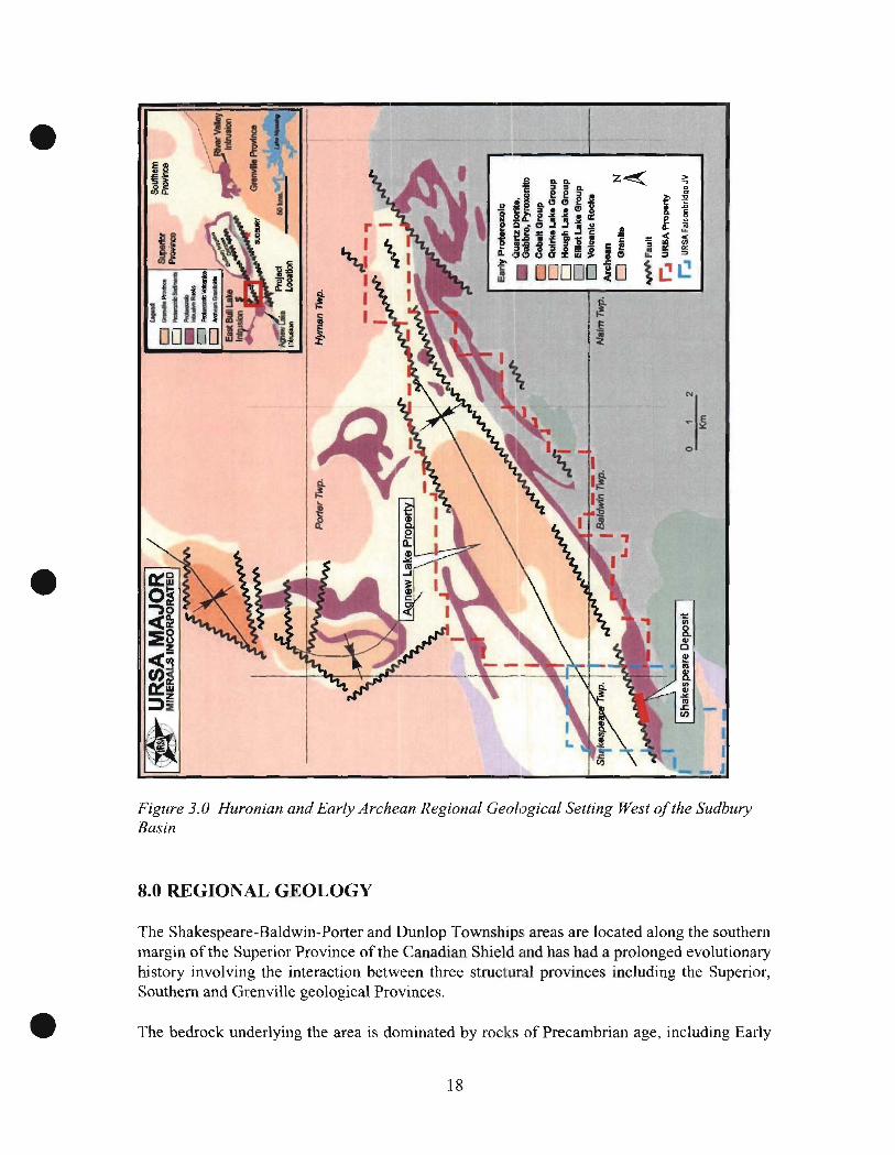
Figure 3.0 Huronian and Early Archean Regional Geological Setting West of the Sudbury Basin
8.0 REGIONAL GEOLOGY
The Shakespeare-Baldwin-Porter and Dunlop Townships areas are located along the southern margin of the Superior Province of the Canadian Shield and has had a prolonged evolutionary history involving the interaction between three structural provinces including the Superior, Southern and Grenville geological Provinces.
The bedrock underlying the area is dominated by rocks of Precambrian age, including Early
18
Precambrian (Archean) felsic plutonic rocks of the Superior Province and Middle Precambrian (Proterozoic) supracrustal rocks of the Huronian Supergroup of the Southern Province. These rocks have been cut by mafic intrusions of several ages including the East Bull Lake Suite, Nipissing Suite and possibly the Sudbury Igneous Complex. The rocks of the Southern Province unconformably overlay the Archean basement rocks. In central Ontario, the Southern Province is defined by the distribution of the Huronian Supergroup succession which is part of a basin forming rift margin.
The Huronian Supergroup consists of a thick sequence of 12,000meters (39,360 feet) of clastic sedimentary rocks. The Huronian rocks include sandstone, conglomerate, siltstone and greywacke, which were derived from the Archean granitoid terrains to the north. Also, mafic to intermediate volcanics, including flows and pyroclastic rocks, are intercalated with the sedimentary units in the basal part of the Huronian Supergroup succession.
The East Bull Lake Suite is part of a major magmatic episode. The intrusions typically occur near the boundary between the Archean Superior Province and the Early Proterozoic Southern Province, and generally appear to have been emplaced as large sills. Magmatism is also manifested in the form of mafic dykes, and as bimodal continental flood basalt sequences (Huronian Volcanics). The most prominent intrusions of the East Bull Lake suite surrounding the project include the East Bun Lake, Agnew and May Township Intrusions.
The Nipissing Suite intrusions are located predominantly within the Huronian Super Group, but are also localized along the Archean-Proterozoic unconformity. The intrusions consist predominantly of gabbros with lesser diabase and granophyre, which range in thickness from a few hundred meters to over a thousand meters and typically outcrop at the present erosion levels as open ring structures, ring dikes, cone sheets, dykes and undulatory si11s. The Nipissing intrusions have traditionally been described as undulatory sheets consisting of a series of basins and arches connected by limbs. The basinal portions of the sills consist of quartz diabase overlain by hypersthene gabbro, and are overlain by vari-textured gabbro with pegmatoidal patches. The arches consist of vari-textured gabbro overlain by quartz diorite, granodiorite, granophyre and aplitic granitoids.
The Sudbury Igneous Complex occurs along the contact between the Superior and the Southern Province and consists of a thick composite mafic-felsic intrusion forming an elliptical ring.
9.0 LOCAL GEOLOGY
The area surrounding the Shakespeare property is underlain predominantly by units of the Huronian-aged Mississaugi quartzite and Nipissing gabbroic intrusives, which trend approximately north-northeast and dip moderately to steeply north. The Mississaugi quartzite's dominate the north and south limit of the land package and are typically whitish, medium grained and uniform.
The ultimate east and west limits for the intrusive have not yet been fully confirmed. The intrusive rock is mainly dark grey and fine grained and consists predominantly of gabbro,
19

however, a range of lithologies from quartz diorite to pyroxenite can be found in various parts of the property. The north and south limits of the intrusion are bounded by the Mississaugi quartzite. Thin units of quartzite also occur locally within the overall limits of the intrusion. The contact between the gabbro and the quartzite's is locally sheared and altered.
One of the major structures underlying the area is the Porter Lake Syncline. The main axis of the syncline is located north of the URSA Major Minerals Incorporated., Shakespeare property and trends in a northeasterly direction. All rocks within the area including the mafic intrusions appear to have been folded into a series of tight to moderately open, upright, complex folds with axes trending roughly parallel to the above syncline. Mapping suggests that there may also be a major anticline located on the Shakespeare Project Property claims, which trends parallel to the Porter Lake syncline. The axis of the projected fold is just south of the Shakespeare deposit and the central part of the fold is defined by a prominent underlying quartzite lens like mass of rocks underlying some of the more visible parts of the anticlinal fold.
There are three main faults crossing the area which appear to be splays of the Hunter Lake Fault. The strike of the faults is generally northeast-southwest and they are steeply dipping. Several more northerly trending cross faults have also been identified in recent mapping.
10.0 BRIEF GEOLOGY and SULPHIDE MINERALIZATION of the SHAKESPEARE INTRUSIVE SUITE and STRATIGRAPHY
The following is a description of the geology and the sulphide mineralization of the Shakespeare Stratigraphy, which has been specifically targeted on the Ursa Major Minerals Inc .. , Shakespeare Project. The descriptions of both the "Regional" and" Local" geology are directly applicable in terms of the mineral exploration efforts on the URSA Major Minerals Incorporated., 100% owned Shakespeare Project Property as well as the adjacent North Shore of Agnew lake Property.
Located on the Ursa Major Minerals Inc., Shakespeare Project Propt!rty, the highly unique Shakespeare Intrusive phase has been identified, which is known to host the very sizable Ni., Cu., and precious metal bearing Shakespeare mineral deposits located north of Agnew Lake in Shakespeare Township. This previously unrecognized intrusive now referred to as the Shakespeare Intrusive - Shakespeare Suite has been traced for a considerable distance along strike off of the Shakespeare Property. Most recently the various rocks which make up the Shakespeare Intrusive Suite have been identified on the Ursa Major Minerals Inc., 100% ground several km's further to the east. There is also some speculation, and some geological and geophysical evidence which may suggest that the Shakespeare stratigraphy, possibly contains sulphide mineralization
The rocks of the Shakespeare Intrusion - Shakespeare suite can be characterized as being made up of a rather unusual assemblage of rocks ranging from a highly felsic dioritic end member through to a highly mafic -- ultramafic, pyroxenitic end member. The rocks which form the hang wall to the Shakespeare stratigraphy include a thick sequence of well bedded
20

and foliated, fine to medium grained quartz arenites rocks with narrow interbeds of more dirty looking arkosic and finer grained silty metasediments.
More specifically the rocks of the Shakespeare intrusion include fine to medium grained biotite quartz diorite. Some of these rocks contain many small to larger scaled fresh to sometimes highly digested faint remnants of highly assimilated quartzite xenolithic materials in the areas that is sometimes referred to as the intrusive roof zone. Where undisturbed, these rocks can vary up to approximately tOo meters (328 feet) in true thickness. The younger quartz diorite rocks overlay the visibly more mafic medium grained, light green to salt and pepper grey - white quartz gabbro materials of approximately 40 to 50 meters (131.20 to 164 feet) in thickness. These rocks contain visibly reduced quartz, an increase in amphiboles and pyroxenes sometimes associated with biotite, illmenite and occasional scattered concentrations of sulphide mineralization. The biotite quartz diorite and the quartz gabbro rocks fonn approximately 12 to 2/3rd
• of the thickness of the stratigraphy and is sometimes referred to as the upper part of the Shakespeare Suite.
The quartz gabbro overlies a markedly increased mafic - melagabbro unit being made up of predominantly amphiboles after pyroxene, associated with 10 to 30 % feldspars, local biotite and illmenite. The melagabbro unit which has an estimated thickness of from approximately 20 to 40 meters (65.60 to 131.20 feet) can be broken into two sub units which include an upper rock fragment bearing Melagabbro, overlying a more massive medium grained, equigranular melagabbro. The rock fragment bearing melagabbro unit is characterized as a 10 to 15 meter thick unit of somewhat altered looking a fine to medium grained amphibole rich rock that has been found to contain an abundance of small mm scaled to large scaled, rarely multi em scaled rounded to angular shard like rock fragments of fonner felsic looking rocks such as the overlying quartzite's and! or quartz gabbros. Occasionally more mafic looking rock fragments have been noted. The underlying fresher looking, more massive equigranular melagabbro which varies in thickness from 10 to 30 meters, (32.80 feet to 98.40 feet) is characterized as containing visibly increased lighter colored feldspars relative to the amphibole pyroxene minerals and has a more distinctive igneous texture.
In places, the lower contact of the Shakespeare Intrusion - Shakespeare Suite fonns a visibly sharp, chilled contact with the adjacent rocks, while at several locations the contact appears evident as a 5 to 15 meter (16.40 feet to 49.20 feet) thick zone of somewhat irregular, sometimes bulbous like admixture of overlying melagabbro rocks and the underlying Nipissing Suite of gabbroic rocks, sometimes referred to as the lower eontact footwall zone.
Sulphide mineralization has been recognized within the entire Shakespeare stratigraphy, but is most concentrated within the lower mafic units. Occasionally small mrn scaled concentrations of fine grained pyrrhotite associated with chalcopyrite, pyrite and I or marcasite, can been seen within the quartz diorite rocks, occurring most notably as sulphide bearing, thin, quartz rich fracture filling veins. Marcasite, and oc(~asionally fme grained dusty like appearances of chalcopyrite, galena and sphalerite have been noted within very tight chlorite rich partings developed within the adjacent quartzite sediments and often within the blue grey hornfels are altered, small to large scaled quartzite xenoliths- megaliths within the quartz diorite rocks.
A visible increase in the presence of strongly developed widespread, spotted to streaky blue grey hornfels alteration of the quartzite xenoliths usually signifies the approaching contact of
21
the area of the underlying quartz gabbro, which usually also marks a significant increase in the visible sulphide content. Quite often the upper parts of the quartz gabbro are often barren of sulphides, or only contain very small, <lmm sized grains as traces of very fine grained pyrrhotite and chalcopyrite, and usually contains no visible pyrite, relative to the overlying rocks. Progressing downwards through the quartz gabbro small Imm to 3mm, sometimes up to 5mm isolated composite blebs of pyrrhotite with minor chalcopyrite can develop, and then will be isolated by more barren quartz gabbro. Within the lower parts of the quartz gabbro unit, an increase in the illmenite content usually signifies an approaching increase in the sulphide content. In these areas there begins an increase in the sulphide content with, in places more concentrated sulphides forming intermittent bands - collections of Imm to 5mm composite blebs of pyrrhotite and chalcopyrite that can develop. One or more of these concentrations collections or bands can form, sometimes being surrounded by relatively barren quartz gabbro.
At or near and sometimes wavering slightly from the often faint contact between the quartz gabbro and the melagabbro rocks, there is a very marked increase in the concentration and collection of 1 to 10mm, sometimes 15 to 20mm well developed composite blebs of fine to medium grained pyrrhotite and chalcopyrite mineralization, forming more consistent looking zones. The overall sulphide content may be slightly erratic and vary from say 1 % to approximately 10% +/- by volume, and can develop for several meters above the contact area.
At or near the contact between the overlying quartz gabbro and the underlying melagabbro there is a very significant increase in the sulphide content which has resulted in a well developed zone of 10% up to 30 or 40% of larger scaled, 5mm to lOmm up to 30mm and 40mm of congealed like, interconnected blebs of fine to medium grained, net textured like pyrrhotite and chalcopyrite. The thickness of these interconnected sulphides range from 0.40 meters to up to 3 meters (1.312 feet to 9.84 feet). Most often the zone of interconnected sulphide mineralization occurs very near the contact between the two rock units, but on occasion was found to waver slightly from one side to the other. Within this collection of sulphides there can be a visible increase in the chalcopyrite content, which equates to noticeably higher grades, and essentially marks the upper ore grade part of the mineral deposit.
The bulk of the sulphide mineralization found within the Shakespeare Intrusion, occurs principally within the melagabbro rocks. Both the rock fragment melagabbro and the massive equigranular melagabbro are consistently mineralized with small blebs and disseminations of fine grained pyrrhotite and chalcopyrite mineralization. Typically the rock fragment bearing melagabbro contains both small scaled 3mm to 5mm to sometimes 10mm blebs associated with small scale <lmm to 3mm individual, interstitial grains, disseminations of tine grained pyrrhotite and chalcopyrite mineralization. The sulphide content of these rocks is very consistent and ranges from 3 to 5%, to 5 to 7%, sometimes up to 10 or 12% pyrrhotite, with 1 to 2% sometime 3% of fine grained chalcopyrite. In the upper part of the melagabbro in contact with the quartz gabbro, the blebby concentrations and finer grained disseminations appear to form a transition zone between the blebby and the disseminated styles of sulphide mineralization. Some of the rock fragments were found to contain fine grained chalcopyrite and pyrrhotite, while in some areas it would appear that sulphides were able to collect or may have been trapped along the edges of some of these rock fragments. Progressing to the lower levels of the unit, there is a noticeable decrease in the dimensions of
22
the sulphide minerals to form a highly consistent collection of smaller scaled mineral grains. Within the upper parts of the melagabbro unit, narrow mm scale to cm scaled chalcopyrite rich, - pyrrhotite bearing quartz, carbonate, chlorite fracture filling veins have commonly developed within these rocks, and becomes less evident lower down in the stratigraphy. Some of the sulphide bearing, fracture fil1ing veins appear to have been somewhat structurally controlled.
Within the massive equigranular melagabbro near the lower most part of the unit, the rocks are very consistently mineralized with 3 to 5%, often 5 to 7% up to 10% or more of well developed small scaled <lmm to 3mm grains of typically fine grained pyrrhotite and 1 to 3% of fine grained chalcopyrite mineralization. On a few rare occasions, small scaled blebs and sulphide bearing fracture filling veins will be present within the unit. The lower part of the consistently mineralized melagabbro marks the lower edge - lower limits of the ore grade portion of the mineral deposit.
The concentrations of sulphide mineralization found to occur within the lower contact zone, the area of the potential mixing of the Shakespeare Intrusive melagabbro with the underlying barren Nipissing gabbro, can be somewhat variable with narrow to wide sections of poorly to well mineralized melagabbro being separated by significant stretches of barren Nipissing gabbros. Within these rocks, concentrations of sulphides are typically in the form of the finer grained disseminations and are consistent with the sulphides found in the massive melagabbro, but can be variable and can range from traces to upwards of 10% by volume in places. These rocks usually do not contain sufficient areas of metal grades to be classified within the main part of the mineral deposit.
The footwall rocks of the Shakespeare stratigraphy include massive fresh looking, usually sulphide poor, quartz gabbro, and pyroxene rich - feldspar gabbros of the Nipissing Suite.
11.0 STANDARD LITHOLOGICAL CODING
Key lithological units have been categorized using an established standardized alphanumeric coding system which was developed initially by Richard Sutcliffe, Geoff Shore, Mike Perkins and Harold Tracanelli during the early stages of the Shakespeare Project mineral exploration programs back in 2002. For a complete listing of the alpha numeric lithological codes please refer to the table below:
Table: 4 Standard Shakes care Project Litholo ical Codes (cont'd next a e)
Standard Lithological Codes as of (October 2002)
Sa granitic dykes and irregular granitic intrusions
7a Lamprophyre dyke
LATE DIABASE DIKES 6a aphanitie olivine diabase dyke materials 6b medium grained olivine diabase
23
FAULT BRECCIA AND RELATED ROCKS 5a Rheomorphic breccia 5b Pseudotachylite, ultramylonite
ULTRAMAFIC TO FELSIC INTRUSIVE ROCKS (MINERALIZED SUITE) 4a aphanitic mafic rocks 4b biotite-pyroxene mela-gabbro «35% felsic minerals) 4c quartz diorite/quartz gabbro 4d biotite quartz diorite (>65% felsic minerals) 4e granophyric / granophyre 4frock fragment phase
MAFIC INTRUSIVE ROCKS (NIPISSING GABBRO) 3a gabbro, amphibole bearing gabbro 3b quartz gabbro (> 10% quartz) 3e coarse-grained to pegmatitic quartz gabbro, granophyric gabbro 3fmetapyroxenite, melagabbro (>65% mafics)
METASEDIMENTS 2a greywacke (25% lithic fragments) 2b siltstone
I a quartzite, quartz arenites 1 b bedded quartzite with siltstone lc arkose 1 d conglomerate
12.0 STANDARD SULPHIDE CODING
Several years ago during the fall and winter of 2003 while conducting one of the earlier Shakespeare Project diamond drilling programs, a sulphide coding system was developed by Harold Tracanelli Getn and was introduced principally to distinguish potential individual parts of the mineralized zone based on the distribution of the contained sulphide mineral occurrences and textures.
The various styles of sulphide mineralization found to be associated with the various parts of the Shakespeare stratigraphy have been categorized in a table below. The bulk of the potentially ore grade type of sulphide mineralization is characterized by an upper section / zone of Blebby "B" style of sulphide mineralization and a lower contiguous section / zone of disseminated "D" style of sulphide mineralization. The blebby like po and cpy mineralization forms the uppermost discemable top part of the Shakespeare mineral deposit, followed by a continuous concentration of disseminated like grains of po and cpy through to the bottom and footwa1l contact of the mineral deposit. The blebby sulphide mineralization constitutes an estimated 8 to 10% of the overall volume of mineralization within the Shakespeare deposit. The bulk of the payable metals contained within this deposit are to be found within the disseminated mineralization.
24
Styles of Sulphide Mineralization, for the Ursa Major Minerals Inc., Shakespeare Project and the Surrounding Areas.
hide Mineralization Codes
I. Intermittent - Peripheral style
• INt Fine grained disseminated py +1- epy +1- po oceurring with the biotite quartz diorite rocks (4d) • [N2 Isolated blebs of po +/- cpy +1- py occurring within the biotite quartz diorite rocks (4d) • IN3 Intennittent development of "band" like features of blebs of po cPY oceurring within the
biotite quartz diorite (4d) • JN4 Secondary py cpy +/- po - marcasite +/- arsenopyrite oecurring within the metasediments
(la) • INS Secondary po cpy py +1- arsenopyrite associated with quartz -- earbonate fraeture fillings
developed within any of the rock types occurring within the peripheral areas of the Shakespeare mineral deposit
2. Blebby Style
• B1 Scattered, to band like features of unconnected blebs of po +/- cpy usually occurring within the quartz diorite 1 quartz gabbro (4c), more specifically quartz gabbro{4c)
• B2 Converged- interconnected blebs of po - cpy, usually developed at or near and often marks the boundary - contact between the quartz gabbro (4c) and the underlying biotite bearing pyroxene melagabbro (4b)
»- BIS Secondary cpy po associated with quartz carbonate fracture fillings which overlapping Bl
»- B2S Secondary cpy po associated with quartz carbonate fracture fillings which overlap B2
3. Disseminated Stvle
• Dl Consistently disseminated po cpy developed within the massive fine medium to coarse grained biotite pyroxene mela gabbro (4b)
• D2 Consistently disseminated po - cpy developed within thc visible rock fragment (4f) bearing, generally fine to medium grained biotite pyroxene mela gabbro (4b)
• DIRB Consistently disseminated po - cpy in gabbroic and or mel a gabbroic rock fragments -xenoliths incorporated within the fine grained matrix of a rheomorphic breccia (5a)
»- Dl f Consistently disseminated po - cpy mineralization which appears to be significantly aligned parallel to an imposcd fabric
» D2f Consistently disseminated po - cpy mineralization which appears to be significantly aligned parallel to an imposed fabric that has been superimposed upon the rock fragment bearing me1a gabbro
»- DIS Secondary cpy po associated with quartz - carbonated fracture fillings which appear to cross cut the Consistently disseminated po - cpy dcveloped within a visible rock fragmcnt (4f) bearing, generally fine to medium grained biotite pyroxene mela gabbro
» D2S Secondary cpy - po associated with quartz ~- carbonatcd fracture t1l1ings which appear to cross cut the consistently disseminated po - cpy devcloped within fine - medium to coarsc grained biotite pyroxene meJa gabbro
»- D3G Primary or secondary remobilization of fine to coarse grained cpy po within se re ations of coarse rained to e mati tic abbroic rocks develo Jed within relativel finer
25
grained mela gabbro
4. Porter - Nipissine Stvle
• PI Fine grained disseminations to occasional blebs of cpy +/- po developed within a gabbro - leuco gabbro (3a)
• P2 Fine grained interstitial disseminations of cpy +/- po developed within fine to coarse grained fibrous metapyroxenite, mela gabbro (3f)
).> PIS Secondary cpy - po +/- py associated with quartz - carbonate fracture fillings which appear to cross cut the fine grained disseminations to occasional blebs of cpy +/- po developed within a gabbro - leuco gabbro
,. P2S Secondary cpy - po +1- py associated with quartz carbonate fracture fillings which appear to cross cut the finc grained interstitial disseminations of cpy +/- po developed within fine to coarse grained fibrous metapyroxenitc, mela gabbro PSC SecondarY - 0 associated with fine ained felsic veinlets
13.0 Exploration Work Performed
Diamond drilling work was performed on the Sutherland Creek Project Area between the dates of February 04th
., 2006 through to February 16th., 2008. Prior to the
commencement of the diamond drill program a thorough review of all the available geological and geophysical was carried out. In addition, despite the fact that there was some snow on the ground, it was still possible to examine some of the elevated exposures of the local geology. The primary objective of the attempted drilling of the two diamond drill holes U-03-85 and U-03-86 was to test and explain the cause of a Time Domain Electromagnetic geophysical anomaly located near the western shore of Sutherland Creek Bay of Agnew Lake.
26

Ursa f\Iajor Minerals Inccorporated C'..eological Interpretations of the West End of the Porter Lake Syncline
• Shakespeare East and West Deposit Area Known occurrences of Shakespeare like rocb Prospectiye location - trend of the
ke~ipeajl~~~i@ suite of
('n ne Geophysics ground IDEM *nODl.alli~s Broulan Reef Mines Ltd .• an m<lly picks
(
I '"
Figure 4:Geophysical and geological target areas-west end of the Porter Lake Syncline
27
•
•
•
lTrsa l\Iajor l\Iiner als Inccorpor~l ted
Geological In terpr etations of the 'Yes t End of the Porter Lake S~-ndine
A g fI ('
Olhine Diabase
.~. :
• Shakespeare East and 'Yes t Deposit Area KnowIl occurrences of Shakespeare like rocks P rospectin locutioll - trend of the Shukespeu ' r ~s·,-~ suite of r ocks
\, I \ - : -~ Ir,'\ I ~ ' <JJ I
:.. t ® Crone Geophysics ground TDEl\I anomali~s V') } . ® Brolll:m Reef I\Iines Ltd .. Airborne El'.J ;J
anomah. - l)ic~s
® Fugro Airborne Geophysics- ' . ",1
C"ltural ~l\I anomalies ~ .- ..:'y ~ ~ ....
.,. ',' , ;. tt.b Il-~ I y! ~w (j".1 ({tt ___
L.--;' -:. -..
I ."
/ -
-
•
43'i 100 4 < 400 435500 435600
....;J
::a ~
0 ~ 0 0
N N 0.()
~ - 0.()
~ 0.()
~ '" 01 6 1203119
~O ~~
,,~ U-03-86
~ 0 ;::
'" '" ~ ~
'" '"
o 0
:5 DUNLOP TWP. ~
t---------------------------------~r_--------------~----------------_J ~ N
W~-E W S
UTM ZONE 17, NAD83
o 50 100 , ! ! I
metres
LEGEND
L Lake
1m Topo Contour
o Claim Boundary
[~-=- i Township
Co:. Drill Collar
~ Surface Trace
SHAKESPEARE TWP. .,.;
U-03-85 . , (-65°-+327°, 129m depdI)
?03 18
~
4 ~ 4 01 1 435 'i0 J 435.600
URSA MAJOR MINERALS INC. Sutherland Creek Area
Shakespeare & Dunlop Twps., Sudbury Mining Division
DRILL PLAN
o o en v M
June 13. 2008
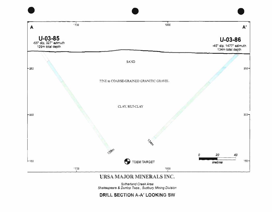
• A
U-03-85 .550 dip, 327 0 azimuth
129m total depth
~250
~200
1-1 50
17'00
• 18'00
SAND
FINE to COARSE·GRAINED GRANITIC GRAVEL
CLAY, SILT·CLAY
S TDEM TARGET
URSA MAJOR MINERALS INC. Sutherland Creek Area
Shakespeare & Dunlop Twps., Sudbury Mining Division
DRILL SECTION A-A' LOOKING SW
o I
• A'
U-03-86 -450 dip, 14770 azimuth
134m total de.Rth
20 I
metre&
40 I
250-
200-
150-

The surface TDEM geophysical anomaly as reported by Crone Geophysics, is located a short distance to the west of the shore of Sutherland Creek Bay of Agnew Lake. The area is characteristically covered with unconsolidated glacial debris of sand, gravel and silt / clay like materials. To the west and north west of the target areas there are a number of protruding outcroppings of traditional Nipissing sill gabbros and basil Nipissing pyroxenitic rocks, that in the area are thought to occur below the potentially north facing Shakespeare Intrusion - stratigraphy.
In an attempt to explore and explain the cause of the geophysical response detected, two opposing, fairly shallow diamond drill holes were attempted to be put down on towards the target, but the drillers were faced with extreme difficulties and came up short of the objective due to the aggressive and constricting nature of the overburden materials.
Unfortunately due to the nature of the overburden materials, the inclined diamond drill holes U-03-85 and U-03-86 were not able to penetrate the overburden materials. Efforts were undertaken between February 04th., 2006 and February 16th., 2006, at which time a total length of263 meters ofNQ casing were sunk for the two diamond drill holes in an attempt to reach the target. Despite valiant efforts by the drilling company, these efforts were not successful in reaching the sub crop. As a result of these fiiled efforts it has not yet been possible to explain the cause of the geophysical anomaly.
Unfortunately due to the highly aggressive nature of the overburden materials, the sub crop was not reached, and therefore no drill core was recovered. As a result of the field examination prior to the drill program, and while drilling was underway 11 representative samples were collected, 3 directly from within the two drill holes and 8 representative grab samples were collected from the surrounding areas where it was possible to examine exposed geology. None of the sample materials collected were ever submitted for assaying, and as such were principally used for examination purposes only. All samples that have been collected are presently being stored at the Ursa - Shakespeare Project Field Office, at the Agnew Lake Lodge.
Diamond Drill Hole Information Charts
Ursa Major Minerals Incorporated
Sutherland Creek TDEM Anomaly Diamond Drilling Exploration
February 20th., 2006
Diamond Drill Hole Locations
Length NAD 83 UTM
Hole-ID Line Station ® Meters Eastings Northings QjQ Start Finish
U-03-85'
U-03-86'
L 1+00E 56+20N 423.12 129.00 0435499 5134935 327 -55 4-Feb-06 8-Feb-06
L1+00E 63+08N 439.52 134.00 0435385 5135118 147 -45 9-Feb-06 16-Feb-06
862.64 263.00 13 Days
Diamond drill holes U-03-85 and U-03-86 were each abandoned in overburden and as such these drill holes
were unable to reach the intended TDEM anomaly target.
28

Ursa Major Minerals Incorporated
Sutherland Creek TDEM Anomaly Diamond Drilling Exploration
February 20th., 2006
Gemcom Header
Hole-ID lS Y. ?; Meters
U-03-85 100 5620 1000 129.00
U-03-86 100 6308 1000 134.00
Ursa Major Minerals Incorporated
Sutherland Creek TDEM Anomaly Diamond Drilling Exploration
February 20th., 2006
Drill Hole Orientations
Date Instrument
Feb 04/06 N/A
Feb 09/06 NIA
Hole-ID
U-03-85*
U-03-86,
Meters
0.00
0.00
distance ll!.l
0.00
0.00
Length (ttl
423.12
439.52
.QiQ
-55
-45
Cumulative
Meterage
129.00
263.00
Azimut'J
327.0
147.0
UTM Coordinates GPS
NAD83 b~ HJT Averaging
0435499 5134935
0435385 5135118 3.00
No diamond drill hole oreintation survey work was out in the drill holes, as no bedrock was reached
Ursa Major Minerals Incorporated
Sutherland Creek TDEM Anomaly Diamond Drilling Exploration
February 20th., 2006
Gemlitho Logging Records
Hole-ID from(ml To(m) Dis!. M's Litho{T ext)
U..Q3-85 0.00 12.00 12.00 08 U-03-85 12.00 39.00 27.00 08 U-03-85 39.00 129.00 90.00 08 U-03-85 129.00 129.00 0.00 EOH
U..Q3-86 0.00 3.00 3.00 08 U-03-86 3.00 46.00 43.00 OB
U-03-86 46.00 130.00 84.00 08 U..Q3-86 130.00 134.00 4.00 OB
U..Q3-86 134.00 134.00 0.00 EOH
29
Comments
Fine grained sand
Fine to coarse grained granitic gravel
Clay - Silt Clay
End of Diamond Drill Hole U-03-85
Fine grained sand
Fine to coarse grained granitic gravel
Clay· Slit Clay
Quartzite, Granitic and Gabbro Boulders with Clay - Silt Clay
End of Diamond Drill Hole U-03-86
Eleven representative samples were collected as result of the initiation of the diamond drilling program.
Table 6: Field Examination Representative Sample Collection Chart
Ursa Major Minerals Incorporated
Sutherland Creel< TDEM Anomaly Diamond Drilling Program
Sutherland Creel< Area of the Shakespeare Project Property
Sutherland Creek Area field examinations and observations carried out by Harold TracaneW, Getn. P.Geo
January 27th., 2006 and Doug MacMillan
For specific sample locations, please see map prepared below being part of the:
OGS Map 2313, GR 139 Shakespeare· Dunlop Township, Ontario.
Representative Sample Collection Chart of Study Purposes
Sample
Number
0385001
0386001
0386002
SCB001
SCB001
SCB001
UTM Nad 83 Coordinates
Easting Northing
DDH U-03-85
DDH U-03-86
DOH U-03-86
435499 5134935
434957 5135034
435007 5134998
Sample Description
Clay materials retrieved from 96 meters down the
diamond drill hole
A fragment of core retrieved from a gabbroic boulder
cut into during attempts to sink caSing thought the
overburden materials at 129 me,ters.
A fragment of core retrieved from a gabbrolc boulder
cut Into during attempts to sink casing thought the
overburden materials at 134 meters.
Sutherland Creek Bay- first sample collected.
Nipissing gabbroic or quartz galjbro possible 4c? like rocks
Couple of small outcrop exposures of mottled ash gray
coloured fine to medium grained massive biotite quartz
gabbro. Possible 4C rocks. (Shakespeare Intrusion)
These rocks contain abundant, visible dark with some
light coloured platy mica, difficu't to estimate the
quartz-amphibole content.
Rocks seem to be a bit grayer than the typical
dispersed grains of cpy.
On some of the broken samples, there is a distinct salt
and pepper textured appearance which is similar in nature to that
of the Shakespeare quartz gabbro materials (4c).
Found a fairly small outcrop of medium to locally coarse grained looks like 3a vari-textured Nipissing gabbro materials, more or less
30

SCB003 434962 5135083
SCB004 435018 5135254
SCBOOS rep grab sample
SCB006 rep grab sample
the typical mottled green and white gabbro.
Rocks contain very small dispersed grains of fine grained
chalcopyrite-pyrrhotite- possible pyrite.
This small outcrop appears to be well surrounded by overburden
area materials, Nipissing gabbro.
Fairly large steep hill like exposure of outcropping and some talus
debris. Massive medium to coarse grained, dark green to nearly
black looking - Nipissing like quartz gabbro?, a lot of visible
dark amphiboles, gray to white feldspars, some visible dark to
bronze looking platy mica minerals.
Rocks contain traces of very fine grained, small scattered grains
of cpy.
The examination of these rocks highly resemble some of the
Nipissing like quartz gabbro. Rocks that Doug MacMillan and I
examined in the areas between the Band C grids on the Ursa
north shore of the Agnew Lake property.
On the northwards facing topo~lfaphic slope, found small oval
shaped outcrop of a medium to coarse grained locally olivine
rich, possible materials of a northeast trending olivine diabase
dyke intruding the surrounding Nipissing gabbro rocks.
Interestingly the location of these particular rocks do not show
any noticeable residual magnetic response. Under favorable
light conditions, the samples of these rocks exhibit what appear
to be cm to sub cm scale feldspar laths.
Although rocks are mildly magnetic, they don't exactly look like
some of the olivine diabase materials examined in the area?
Might it be possible that these rocks may be related to the
Agnew Lake Complex Gabbro-J'northsitic Intrusion that are
exposed to the west side of Agnew Lake?
Well developed cliff like exposure along the shore of Agnew Lake
of a medium grained felty ophitic metapyroxenite-Nipissing. This
is very good exposure to these rocks. In places there is a clearly
distinct fabric-parallel to shore of the lake the needle Ilke
amphiboles appear to be lighter in color than some of the
other Nipissing meta pyroxenite rocks in the area, this may be due
to the effects of the structural deformation in the area.
In a few places it is possible to observe some minor quartz
veining appearing to develop parallel to the fabric in these rocks.
Well developed cliff like exposure of a fine to medium grained
massive Nipissing meta pyroxenite. In places there rocks are quite
massive looking and have some widely spaced, sharp orthogonal
jointing. These rocks were found to contain very small interstitial
31
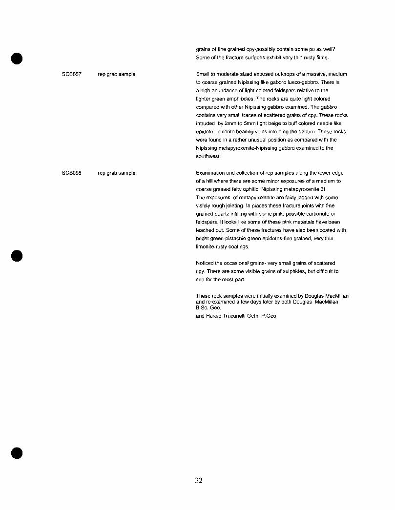
SCB007 rep grab sample
SCB008 rep grab sample
grains of fine grained cpy-possibly contain some po as well?
Some of the fracture surfaces exhibit very thin rusty films.
Small to moderate sized exposed outcrops of a massive, medium
to coarse grained Nipissing like gabbro lueco-gabbro. There is
a high abundance of light colored feldspars relative to the
lighter green amphiboles. The rocks are quite light colored
compared with other Nipissing gabbro examined. The gabbro
contains very small traces of scattered grains of cpy. These rocks
intruded by 2mm to Smm light beige to buff colored needle like
epidote - chlorite bearing veins intruding the gabbro. These rocks
were found in a rather unusual position as compared with the
Nipissing metapyroxenite-Nipissing gabbro examined to the
southwest.
Examination and collection of rep samples along the lower edge
of a hill where there are some minor exposures of a medium to
coarse grained felly ophitic. Nipissing metapyroxenite 3f
The exposures of metapyroxenite are fairly jagged with some
visibly rough jointing. In places these fracture jOints with fine
grained quartz infilling with some pink, possible carbonate or
feldspars. It looks like some of these pink materials have been
leached out. Some of these fractures have also been coated with
bright green-pistachio green epidotes-fine grained, very thin
limonite-rusty coatings.
Noticed the occasional gralns- very small grains of scattered
cpy. There are some visible grains of sulphides, but difficult to
see for the most part.
These rock samples were initially examined by Douglas MacMillan and re-examined a few days later by both Douglas MacMillan B.Sc. Geo.
and Harold Tracanelli Geln. P.Geo
32
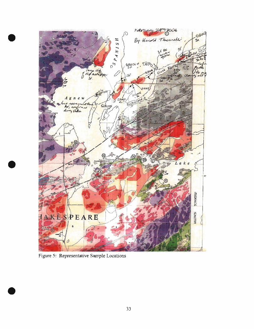
Figure 5: Representative Sample Locations
f~.r,~:~r'("lOV6 ~ '0
8'1 ' U~~ 71'3-tt.a.~ r
~
33

14: Discussions and Results of the Diamond Drilling Program
Following the abandonment of diamond drill hole U-03-85 on mining claim S-30 16239 at a depth of 129 meters in an attempt to intercept the target from the direction of 147 degrees Azimuth, a second attempt to intercept the target from the 327 degree Azimuth direction was made by putting down diamond drill hole U-03-86 located on mining claim S-3106237.
The following is a good description of part of the efforts in terms of the diamond drill crews attempt to sink the casing through the very aggressive overburden materials. The source of the information has been ultimately derived from an internal company memorandum describing the exploration and some speculation as to the potential causes of the Time Domain Electromagnetic (TDEM) target.
The efforts, results and theorization have been presented as follows:
During the night shift of February 15th., 2006, the drm crew was required to sink the NQ
casing a little further to a depth of 134 meters (439.52 feet). Jimmy has reported that during the night, Andrew Downing was able to run the core barrel far enough ahead to jill up the core tube. As it turned out the core tube wasfWed with cobble sized fragments
stones of mainly jine grained quartzite intermixed with pink granite, and the occasional gabbroic stones. The bringing up of the various stones clearly suggests that the casing had not yet reached the bedrock but may be close.
Some time during the night sh(ft last night, while attempting to resume coring operations Andrew Downing, and his helper Tyler experienced some problems which were described as what was thought to be associated with a worn out NQ core bit. As a result the crew proceeded to begin the pulling of the NQ rods so as to do a bit change. At some point during this process the drillers came to the realization that the NQ casing had gotten broken off. A little later, it was determined that the NQ casing had broken off at 54 meters (177.12 feet) above the bottom of the hole. At that time the bottom of the casing -hole was at 134 meters. This morning I received a call from Tom Downing, Bruce Downing's brother, at which time he indicated that there was some potentially serious problems with the drill hole. Tom described that the casing had been broken offin the hole. He and the crew members had gone over the situation and came to the conclusion that there was little that could be done to save this drill hole, and at best all reasonable attempts would be made to recover as much of the drill casing and rods as possible.
Ufifortunately due to the breaking off of the casing, diamond drill hole U-03-86 will have to be abandoned, having sunk 134 meters of casing, and although probably fairly close to the sub crop, no actual solid rock in place l-1laS confirmed.
At approximate~y W:30am a site visit was made to the drill, at which time it was possible to speak directly with Jimmy and Eric about the breaking off of the casing situation, and the drill gear recovery plan.
34

At the time of the visit, Jim was in the midst of pulling out the NQ drill rods, and indicated that it will be possible to recover the entire drill rod string. At that time Jim figured that it would take about 2 hours to complete this task.
Once Jim has completed the pulling of the drill rods he will:
1. Begin to pull out the 80 or so meters (262.4 feet) ofNQ casing. the pulling he says could befairly slow going and may take a few hours to accomplish this task.
2. Once he has completed pulling the 80 meter segment of casing, he will then secure a "rod tap" to the NQ casing, then attempt to re enter the hole where there may be a chance of possib(v tapping into the 54 meter lower segment of the NQ casing, and possibly retrieval. Jim thinks that once he pulls out the upper segment of the casing, the outline of the original hole below the end of the HQ casing could possibly cave in potentially making the way impassable for the tap. Jimmy indicated that it would be worth a try.
3. Once all or part of the NQ casing is recovered, then the HQ casing will be pulled out, and the work on diamond drill hole U-03-86 will have been officially completed.
Once all of the gear has been pulled out, the drillers will still have a fair bit of work to clean off the drill rods of the drilling mud and so on be/ore things get frozen together. By the time the drillers retrieve, clean up and pack up their gear, it will likely be some time tomorrow before they would be able to hook up the skidders and begin moving.
Unfortunately the attempted drilling of Sutherland Creek TDEM target with diamond drm holes U-03-85 and U-03-86 has turned out to be a very disappointing and frustrating exercise. In all the years of having been involved in mineral exploration, 1 have never attempted to drill targets that have been under such great thicknesses of unconsolidated overburden materials. This is also a first for Downing drilling as well, and the Downing drill crew tried very hard to work their way through these veT:V difficult materials, using the LF-70 which is probab(v a bit on the light side/or such difficult situations.
It is also very frustrating that at this time, despite our best efforts and intentions, we have not been able to definitively explain the cause of the Sutherland Creek TDEM anomaly, and we may have actually been pretty close.
It is certain(v possible, and may be valid to suggest that the possible cause of the TDEM anomaly could be the fine grained - wet clay materials that occur below sand and gravel materials in the area. The interpretation o/the positions of where the clays were encountered within diamond drill holes U-03-85 and U-03-86, would suggest that the interface between the over(villg coarse grained, granitic sand and gravel materials and
35
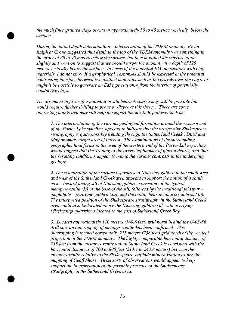
the much finer grained clays occurs at approximately 30 to 40 meters vertically below the surface.
During the initial depth determination interpretation of the TDEM anomaly, Kevin Ralph at Crone suggested that depth to the top of the TDEM anomaly was something in the order of 80 to 90 meters below the surface, but then mod~fied his interpretation slightly and went on to suggest that we should target the anomaly at a depth of 120 meters vertically below the swface. In terms of the potential EM interactions with clay materials, I do not know If a geophysical responses should be expected at the potential contrasting interface between two distinct materials such as the gravels over the clays, or might it be possible to generate an EM type response from the interior of potentially conductive clays.
The argument in favor of a potential in situ bedrock source may still be possible but would require further drilling to prove or disprove this theory. There are some interesting points that may still help to support the in situ hypothesis such as:
1. The interpretation of the various geologicaljormation around the western end of the Porter Lake syncline, appears to indicate that the prospective Shakespeare stratigraphy is quite possibly trending through the Sutherland Creek TDEM and Mag anomaly target area of interest. The examinations of the surrounding geographic landforms in the area of the western end of the Porter Lake syncline, would suggest that the draping of the overlying blanket of glacial debris, and that the resulting landforms appear to mimic the various contrasts in the underlying geology.
2. The examination of the surface exposures of Nipissing gabbro to the south west and west of the Sutherland Creek area appears to support the notion of a south east - inward facing sill of Nipissing gabbro, consisting of the typical metapyroxenite (3j) at the base of the sill, followed by the traditional feldspar amphibole - pyroxene gabbro (3a), and the biotite bearing quartz gabbros (3b). The interpreted position of the Shakespeare stratigraphy in the Sutherland Creek area could also be located above the Nipissing gabbro sill, with over~ving Mississaugi quartzite's located to the east of Sutherland Creek Bay.
3. Located approximately J 10 meters (360.8feet) grid north behind the U-03-86 drill site, an outcropping of metapyroxenite has been confirmed. This outcropping is located horizontally 225 meters (738feet) grid north of the vertical projection of the TDEM anomaly. The highly comparable horizontal distance of 738 feetfrom the metapyroxenite unit at Sutherland Creek is consistent with the horizontal distances of 700 to 800jeet (213.4 to 243.8 meters) between the metapyroxenite relative to the Shakespeare sulphide mineralization as per the mapping of Geoff Shore. These sorts of observations would appear to help support the interpretation of the possible presence of the Shakespeare stratigraphy in the Sutherland Creek area.
36

4. Although the TDEM anomaly could be caused by overburden clay materials in a channel way,it is also coincidental with a Fugro residual magnetic anomaly. In this particular area it may also be possible that the very thick overburden may somehow have some sort of a masking effect on the EM response.
5.Although in this diamond drill hole U-03-86 or U-03-85 it was not possible to reach and actually confirm the location of the bed rock, it is possible that the end location of the casing may have gotten fairly close to the sub crop. It may also be possible that the casing may have been following along the edges of a buried talus slope. Although many of the fragments cobbles and smaller scaled granules were made up of quartzite's and dirty quartzite's, there were also several granite cobbles and a number of gabbroic cobbles and a few larger scaled fragments. It is interesting to note here that within the various granular materials brought up in the core tube, there were three larger scaled fragments in the order of 1 0 to 20 ems in length that were carefully examined, and could be quite exciting as they may relate directly to the favorable Shakespeare stratigraphy, possibly located close by. Two of these fragments examined resemble massive, medium grained Shakespeare like quartz gabbro (4c). These rocks contain clearly visible quartz, both light to darker colored mica minerals, very fine grained traces ("if pyrrhotite and chalcopyrite, and some visible isolated grains of illmenite. One of the three, and most interesting of the fragments resembled Shakespeare melagabbro (4b). These rocks were noticeab(v more mafic than the previous(y described materials. There was no visible quartz noted within these rocks. and some lighter colored mica minerals were observed. There was a visible increase in the pyrrhotite, chalcopyrite and illmenite content. The sulphide content is estimated to be in the order of trace to :0% of visible scattered <lmm sized grains.
A number of the quartzite - dirty sedimentfragment materials exhibited mild to moderate fabrics, which may be suggestive of the presence of near by structural zones.
The area certainly may not be without potential complications which could cause some interpretation problems.
There may be some sort ofstructural zone passing by the Sutherland Creek drilling area, which may have resulted in the formation of a deep canyon like valley which would have later been filled with debris, possibly as part of a former Spanish River channel way.
On the west shore of Sutherland Creek Bay located approximately 1 mile (1.6 kilometers), north east of the Sutherland Creek drilling area, there is an extensive exposure of the Nipissing metapyroxenite. On the opposite side of the bay, a few hundred feet away, there are large, visibly altered exposures of Mississaugi quartzite materials. In this area it is interesting to note that it would appear that the Nipissing sill stratigraphy has been possibly been overturned, relative to the Nipissing sill rocks examined to the south. It is also interesting to note that on the north side of the large
37
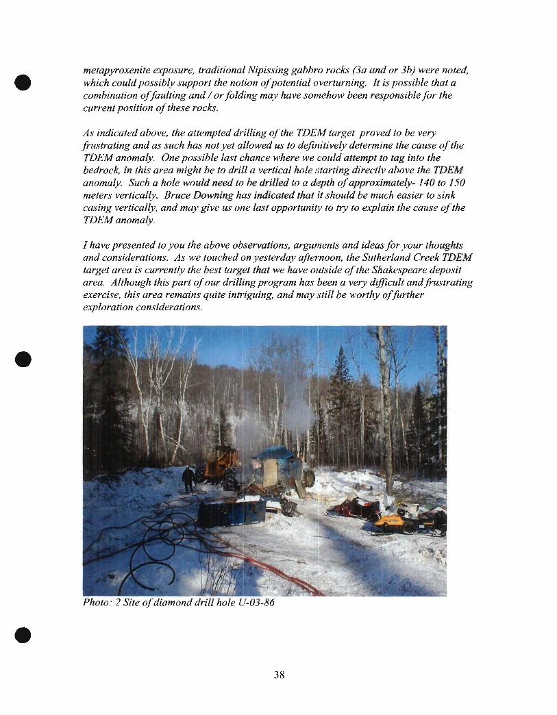
metapyroxenite exposure, traditional Nipissing gabbro rocks (3a and or 3b) were noted, which could possib(y support the notion of potential overturning. It is possible that a combination of faulting and / or folding may have somehow been responsible for the current position of these rocks.
As indicated above, the attempted drilling of the TDEM target proved to be very frustrating and as such has not yet allowed us to definitively determine the cause of the TDEM anomaly. One possible last chance where we could attempt to tag into the bedrock, in this area might be to drill a vertical hole starting direct(y above the TDEM anomaly. Such a hole would need to be drilled to a depth of approximately- 140 to J 50 meters vertically. Bruce Downing has indicated that it should be much easier to sink casing vertically, and may give us one last opportunity to try to explain the cause of the TDEM anomaly.
I have presented to you the above observations, arguments and ideas for your thoughts and considerations. As we touched on yesterday afternoon, the Sutherland Creek TDEM target area is currently the best target that we have outside of the Shakespeare deposit area. Although this part of our drilling program has been a velY difficult and frustrating exercise, this area remains quite intriguing, and may still be worthy offurther exploration considerations.
Photo: 2 Site of diamond drill hole U-03-86
38
Photo: 3 Facing south at the narrows oJSutherland Creek Bay. Large exposure oj Nipissing rnetapyroxenite on the right of the photograph, and Mississaugi quartzites on the left hand side of the photograph.
39
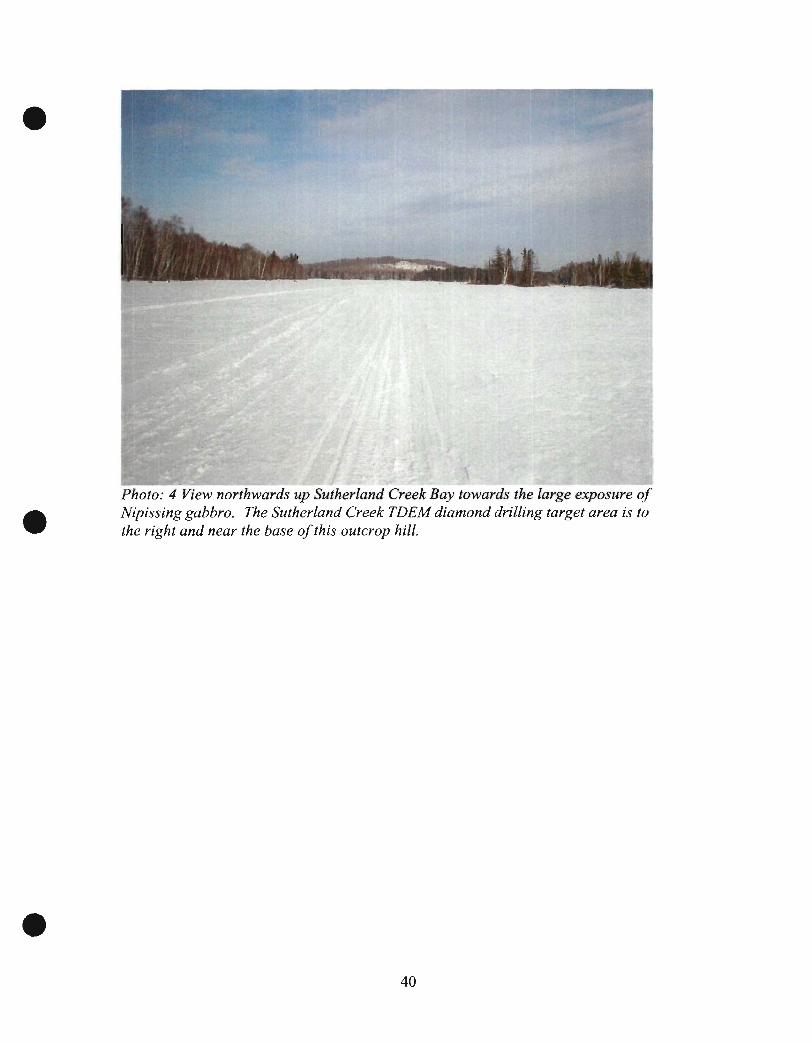
Photo: 4 View northwards up Sutherland Creek Bay towards the large exposure of Nipissing gabbro. The Sutherland Creek TDEM diamond drilling target area is to the right and near the base of this outcrop hill.
40

\ Photo: 5, Facing more or less southwards. along the long axis oJthe outcrop exposures oj the Nipissing gabbro rocks.
15.0 CONCLUSIONS
The URSA Major Minerals Incorporated., Sutherland Creek Area of the Shakespeare Project Property, is located near the north eastern areas of Shakespeare and south eastern portion of Dunlop Township, in the Provincial geographic District of Sudbury, Sudbury Mining Division, Ontario.
The Sutherland Creek Area - portion of the mining claim property consists of 5 claims totaling approximately 38 units essentially situated over the mainly south facing Precambrian Huronian sedimentary rocks of the north limb of the Porter Lake Synclinorium, located west - north west along strike from the Shakespeare West mineral deposit. The Sutherland Creek diamond drilling program was essentially carried out in the south east corner of mining claim S-3016237 in south eastern Dunlop Township, and the north east corner of mining claim S-3016239. The primary objective of the diamond drill program was to attempt to test a Crone Geophysics TDEM geophysical which may correspond with the potential trace of the Shakespeare stratigraphy.
Unfortunately due to the nature of the overburden materials, the inclined diamond drill holes U-03-85 and U-03-86 were not able to penetrate the overburden materials. Efforts were undertaken between February 04th
., 2006 and February 16th., 2006, at which time a
41

total length of263 meters ofNQ casing were sunk for the two diamond drill holes in an attempt to reach the target. Despite valiant efforts by the drilling company, these efforts were not successful in reaching the sub crop. As a result of these failed efforts it has not yet been possible to explain the cause of the geophysical anomaly. Once a decision was made to abandon the drilling attempts, all of the NQ casing and the~ casing shoes were all recovered for reuse.
The primary objective of the diamond drilling exploration program was to test the cause of a ground geophysical anomaly that may possibly be associated with sulphide mineralization associated with the trend of the Shakespeare Intrusive stratigraphy which has been interpreted to occur, rounding the western end of the Porter Lake Syncline.
Owing that it has not been possible to explain the geophysical anomaly, careful considerations should be given to initiating further exploration efforts to make a second attempt at exploration of the anomaly.
16.0 RECCOMMENDATIONS
During the mid winter of 2006 an attempt was made to put down two inclined diamond drill holes to test the cause of a ground geophysical anomaly that had been detected and reported on earlier. The objectives of the diamond drilling program was to determine if such an anomaly may be caused by sulphide mineralization associated with the possible Shakespeare stratigraphy interpreted to occur in that particular area. Unfortunately the diamond drilling efforts were not successful in reaching the target or allowing for a full explanation as to the cause of the anomaly. Some evidence has been brought to light from both the examination of materials brought up from within the drill holes, but also from an examination of the surrounding geology that would possibly support the theory that the cause of the geophysical anomaly may be located in the bedrock below. As such consideration should be given to and a recommendation put forth that would make it possible to continue to explore the cause of the presently unexplained geophysical anomaly. Such efforts could potentially result in the discovery of valuable mineral deposits.
As an initial recommendation, it should be possible to make a second attempt to test the geophysical anomaly by putting down a vertical diamond drill hole to an estimated depth of approximately 300 meters. The all inclusive cost to carry out such a program has been estimated to be in the order 0[$40,000.00 +1-.
42

•
•
•
17: CERTIFICATE OF QUALIFICATIONS
Of
Harold J. Tracanelli, GETN, P.Geo.
I, Harold Joseph Tracanelli,GETN, P.Geo., 1156, currently reside at 192 North Shore Road, Box 122, Onaping, Ontario POM 2RO, Dowling Township, in the City of Greater Sudbury, Ontario.
In 1986 I graduated from Cambrian College of Applied Arts and Technology, Barrydowne Campus in Sudbury, Ontario, with a Geological Engineering Technician Diploma.
I have been involved in prospecting like efforts since 1976, and since 1983 have been actively engaged, as an Exploration Geologist participating in the many required duties and functions and performing an assortment of mineral exploration related work..
I am a member of the Prospectors and Developers Association of Canada, the Sudbury Prospectors and Developers Association, and the Ontario Prospectors Association. I am a member in good standing of the APGO, 1156.
I have participated directly in the diamond drilling program related investigate field work and report preparation activities on the URSA Major Minerals Incorporated, Shakespeare Project Sutherland Creek area, located in Dunlop and Shakespeare Townships, Sudbury Mining Division, Ontario.
This report; describes the nature of the reconnaissance type field work which was carried out on the property during late January and into February of 2006. This report is based exploration activities, results and observations; that have been made and prepared from all pertinent data available both published and or unpublished, and from my personal experiences while working on the project.
My efforts on the Shakespeare Property, Sutherland Creek Area have been as an employee of URSA Major Minerals Incorporated. I presently hold no position of office or retain any interests in the company, either direct or indirectly, nor do I currently own any interest or securities in the company and or its affiliates.
Dated and Signed, in the Greater City of Sudbury, Ontario, this 19th., Day of June 2008.
~ ;2.~;·'flr.?al8 Date
43
18.0 LIST OF REFERENCES USED WITHIN THIS REPORT.
Tracanelli, J Harold. GETN. P.Geo. Field Notes January 26th., 2008
Kallio, Eric A; 2002a;
Technical report for the Shakespeare property, Shakespeare Township, Ontario NTS 41I/5, for URSA Major Minerals Incorporated. Volume 1 of2.
Hennessey, B. Terrence, P GEO and Puritch, Eugene, P Eng. May 2004
Micon International Ltd. An updated mineral resource estimate for the Shakespeare deposit. Shakespeare Property near Espanola, Ontario. Volumes I and II Report.
MND & M's Sudbury Resident Geologist office. 2002
MNR 1 "= Yt mile air photographs (73-4615-11-126)
MND & M's- Provincial Mining Recorders Offices, Sudbury, Ontario 2008.
Claims III, Shakespeare Township, Sudbury Mining Division, Ontario G-300 1.
URSA Major Minerals Incorporated HJT Journals.
Tracanelli, Harold, GETN. P. Geo 2006.
Card, K.D and Palonen, P.A 1976: Geology of the Dunlop-Shakespeare Area, District of Sudbury; Ontario Div. Mines
GR 139, 52p. Accompanied by Map 2313.
44
• APPENDIXl
Field Examinations and
Observations
• By: Harold Tracanelli Getn; P.Geo
And
Douglas MacMillan Geo .
•

Ursa Major Minerals Incorporated Sutherland Creek TDEM Anomaly Diamond Drilling Program
Sutherland Creek Area of the Shakespeare Project Property
Sutherland Creek Area field examinations and observations carried out by Harold Tracanelli, Getn. P.Geo January 27th., 2006 and Doug MacMillan
Representative Sample Collection Chart of Study Purposes Page 1
Sample UTM Nad 83 Coordinates Number Easting Northing 0385001 DDH U-03-85
0386001 DDH U-03-86
0386002 DDH U-03-86
SCB001 435499 5134935
SCBOO1 434957 5135034 possible 4C rocks
SCB001 435007 5134998
3a vari-textured.
•
Sample Description Clay materials retrieved from 96 meters down the diamond drill hole A fragment of core retrieved from a gabbroic boulder cut into during attempts to sink casing thought the overburden materials at 129 meters. A fragment of core retrieved from a gabbroic boulder cut into during attempts to sink casing thought the overburden materials at 134 meters. Sutherland Creek Bay- first sample collected.
Couple of small outcrop exposures of mottled ash gray coloured fine to medium grained massive biotite quartz gabbro. These rocks contain abundant, visible dark with some light coloured platy mica, difficult to estimate the quartz-amphibole content. Rocks seem to be a bit grayer than the typical dispersed grains of cpy. On some of the broken samples, there is a distinct salt and pepper textured appearance which is similar in nature to that of the Shakespeare quartz gabbro materials (4c).
Found a fairly small outcrop of medium to locally coarse grained looks like vari-textured Nipissing gabbro materials, more or less the typical mottled green and white gabbro. Rocks contain very small dispersed grains of fine grained choleopyrite-phyrrotite- possible pyrite,
• •
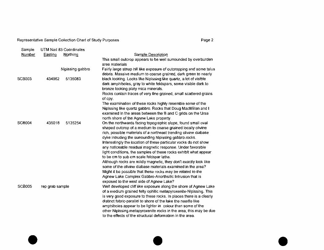
Representative Sample Collection Chart of Study Purposes Page 2
Sample Number
SCB003
SCB004
SCB005
•
UTM Nad 83 Coordinates Easting Northing
Nipissing gabbro
434962 5135083
435018 5135254
rep grab sample
Sample Description This small outcrop appears to be well surrounded by overburden area materials Fairly large steep hill like exposure of outcropping and some talus debris. Massive medium to coarse grained, dark green to nearly black looking. Looks like Nipissing like quartz, a lot of visible dark amphiboles, gray to white feldspars, some visible dark to bronze looking platy mica minerals. Rocks contain traces of very fine grained, small scattered grains of cpy. The examination of these rocks highly resemble some of the Nipissing like quartz gabbro. Rocks that Doug MacMillan and I examined in the areas between the Band C grids on the Ursa north shore of the Agnew Lake property. On the northwards facing topographic slope, found small oval shaped outcrop of a medium to coarse grained locally olivine rich, possible materials of a northeast trending olivine diabase dyke intruding the surrounding Nipissing gabbro rocks. Interestingly the location of these particular rocks do not show any noticeable residual magnetic response. Under favorable light conditions, the samples of these rocks exhibit what appear to be em to sub cm scale feldspar laths. Although rocks are mildly magnetic, they don't exactly look like some of the olivine diabase materials examined in the area? Might it be possible that these rocks may be related to the Agnew Lake Complex Gabbro-Anorthsitic Intrusion that is exposed to the west side of Agnew Lake? Well developed cliff like exposure along the shore of Agnew Lake of a medium grained felty ophitic metapyroxenite-Nipissing. This is very good exposure to these rocks. In places there is a clearly distinct fabric-parallel to shore of the lake the needle like amphiboles appear to be lighter in colour than some of the other Nipissing meta pyroxenite rocks in the area, this may be due to the effects of the structural deformation in the area .
• •
Representative Sample Collection Chart of Study Purposes Page 3
Sample UTM Nad 83 Coordinates Number Easting Northing
SCB006 rep grab sample
SCB007 rep grab sample
SCBQ08 rep grab sample
•
Sample Description I n a few places it is possible to observe some minor quartz veining appearing to develop parallel to the fabric in these rocks.
Well developed cliff like exposure of a fine to medium grained massive Nipissing metapyroxenite. In places there rocks are quite massive looking and have some widely spaced, sharp orthogonal jOinting. These rocks were found to contain very small interstitial grains of fine grained cpy-possibly contain some po as well? Some of the fracture surfaces exhibit very thin rusty films. Small to moderate sized exposed outcrops of a massive. medium to coarse grained Nipissing like gabbro lueco-gabbro. There is a high abundance of light coloured feldspars relative to the lighter green amphiboles. The rocks are quite light coloured compared with other Nipissing gabbro examined. The gabbro contains very small traces of scattered grains of cpy. These rocks intruded by 2mm to 5mm light beige to buff coloured needle like edidate- chlorite bearing veins intruding the gabbro. These rocks were found in a rather unusual position as compared with the Nipissing metapyroxenite-Nipissing gabbro examined to the southwest.
Examination and collection of rep samples along the lower edge of a hill where there are some minor exposures of a medium to coarse grained felty ophitic. Nipissing meta pyroxenite 3F The exposures of metapyroxenite are fairly jagged with some visibly rough jointing. In places these fracture jOints with fine grained quartz infilling with some pink, possible carbonate or feldspars. It looks like some of these pink materials have been leached out Some of these fractures have also been coated with bright green-pistachio green epidotes-fine grained, very thin Iimonate-rusty coatings.
Noticed the occasional grains- very small grains of scattered cpy. There are some visible grains of sulphjides, but difficult to see for the most part .
• •

Representative Sample Collection Chart of Study Purposes Page 4
Sample Number
•
UTM Nad 83 Coordinates Easting Northing §ample Description
These rock samples were initially examined by Douglas MacMillan and re-examined a few days later by both Doug MacMillan and Harold Tracanelli.
• •
M_aJC?rJ",1jn~r.a!§_lnc. "c.o:;)~"' ___ Q.' __ E~oject
t ___-:-LI:_J ---nbridge Grid Location:
UT~J"JAD -83Coordi~ N()rthings __ LEasting~
Azimuth of Diamond DriIlJ:lgle:.l_ Inclination of Diamond Drill Hole:
l?.!l!~ D@f11on~~!ill Hole S(?gtt.e .. :_d_"-------- __ . I Date Diamond Drill Hole Started ;Dat~~DlarlloridQrlll1:!~e Finish-e---d---.-- ... _ ........ __ ._~
JPJ.~!TI(mdJ?rHI Hole LQ9.9.~QJ?:i~ i Drill Core Sampling Carried out By
~ ····~-T~-- r-·-· --------l ...... -~ - -- -_ .. - ~----- ------. -------1------ ____ L -- -----.-.---.- . - ---+---.---
)A~~'!:il:§!> Work Orde~J'_Jurnber ...... _____ ..... _ __L __
______ 151 Mo~~!~te~() intense deformati0rlwith visit:>I~~()~ suspected ~ __ lC!i~locationL~ep...9!atiorl.Qf R<LQ~yelo~l"l1en1.Pf faulL9()uge J. ____ _
.i~2 We~~to _intens~.iil"lt!ct_loca~ to ~!~~sp~~~~ fol iatj~n_J __ . 153 Open, late fracturing I rubble devel'd in the core, jOint sets :
-------- --j ------ .-.------. ----... --.. ----- ------.-- ---- .. -- TStr1"""'- - ... -------... - -- ---- -- ----I Interv~!~Jn-J~~eters EI Minor l:!.tb()109Y_r~tructural Zones
--+-_~ __ I __ '''''''~~_+-.,;;~.=-I . __ Ma[o-r Uthologi- =~::~=~~:-I .. -~':sLkr -- ._ =-BdefDescnptlOn---(~ (j --c-----------
i Fine_g!~!rl~~ sanQ.!TIiJterial~ _____ f____· ---)---j ---.---.. I--~-i
46 134 88
ine(~rJh~surf~e·_~I----·- -~-. 1_ --- ------ ··t·---I , I ,
-. cFi-ne toro~-;~egrained granite·- - -r------ ,--: sa_nd~~dgra~el material. it-- -- ------r----- i
-r --1- -I _____________ .. _._ I __ __'.
Fine g!~ined ~lCly ... silt_materi?t~_J_._ i sam"'ples of som~ofthe Sh~_es['leare T--'
beg!~to e_I'lGounter quartzite- I boulder~were_cQ!lected from the drill
i9!?nite andgGJbb.r:.~i<::-,---s_o_me L ____ _ !Shakespeare like rocks near -- I ..
---}md or~~~_=.~·- - '---+1- sampl~from a dept~of~4 metres
--I ..... -.. -... --.. ~- - ___ .1_
~~---- ._-
iw~i~thi-'!....veryJ.f:lick .?'_n_d_difficult ____ + __ ioverburden conditions, the NQ ,~-~~--- ~-.--~-- .. -~-- --.~
i drill_~?~iD.9.~!pk~ off atJii _Jmetres _~ove the bottom of
jthe hole. _____ _
---1 .. ~ .. __ + ___ b __ ox funQft~~gu?'~tegranite g...?'i:>.~ro_r_u"~ ... __ 1
i currently stored at the Shakespeare core shack ---·-t .-. -----~.-. --. ---'---._--.-_ __ .. 1_'_'--_. __ 1.. ___ . _
I -- +-,
Minerals Inc.

• • •