Embed Size (px)
Citation preview
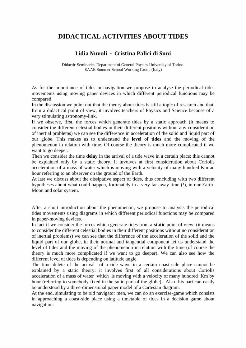
DIDACTICAL ACTIVITIES ABOUT TIDES
Lidia Nuvoli - Cristina Palici di Suni
Didactic Seminaries Department of General Physics University of Torino.
EAAE Summer School Working Group (Italy)
As for the importance of tides in navigation we propose to analyse the periodical tides
movements using moving paper devices in which different periodical functions may be
compared.
In the discussion we point out that the theory about tides is still a topic of research and that,
from a didactical point of view, it involves teachers of Physics and Science because of a
very stimulating astronomy-link.
If we observe, first, the forces which generate tides by a static approach (it means to
consider the different celestial bodies in their different positions without any consideration
of inertial problems) we can see the difference in acceleration of the solid and liquid part of
our globe. This makes us to understand the level of tides and the moving of the
phenomenon in relation with time. Of course the theory is much more complicated if we
want to go deeper.
Then we consider the time delay in the arrival of a tide wave in a certain place: this cannot
be explained only by a static theory. It involves at first consideration about Coriolis
acceleration of a mass of water which is moving with a velocity of many hundred Km an
hour referring to an observer on the ground of the Earth.
At last we discuss about the dissipative aspect of tides, thus concluding with two different
hypotheses about what could happen, fortunately in a very far away time (!), in our Earth-
Moon and solar system.
After a short introduction about the phenomenon, we propose to analysis the periodical
tides movements using diagrams in which different periodical functions may be compared
in paper-moving devices.
In fact if we consider the forces which generate tides from a static point of view (it means
to consider the different celestial bodies in their different positions without no consideration
of inertial problems) we can see that the difference of the acceleration of the solid and the
liquid part of our globe, in their normal and tangential component let us understand the
level of tides and the moving of the phenomenon in relation with the time (of course the
theory is much more complicated if we want to go deeper). We can also see how the
different level of tides is depending on latitude angle.
The time delete of the arrival of a tide wave in a certain coast-side place cannot be
explained by a static theory: it involves first of all considerations about Coriolis
acceleration of a mass of water which is moving with a velocity of many hundred Km by
hour (referring to somebody fixed in the solid part of the globe) . Also this part can easily
be understood by a three-dimensional paper model of a Cartesian diagram.
At the end, simulating to be old navigator men, we can do an exercise-game which consists
in approaching a coast-side place using a timetable of tides in a decision game about
navigation.
The navigators have always had to take into the greatest consideration the problems of
tides.
We have experimented at various school levels and now we propose an activity to promote
the approach of a physical interpretation of the important phenomenon of tides.
We also prepared a card for the experimental survey but, as Turin is not on the sea (!) we
passed our card to a Nautical Institute for the experimentation on the Adriatic Sea.
Now we propose the activity done in Turin that through handmade devices has allowed to
analyse this complicated phenomenon in a comparatively easy and involving way.
The first step brings us to consider the Moon as the cause of the phenomenon and justifies
the existence of high tides every 12 hours.
The second introduces the action of the solar mass and leads to consider the complications
related to the angles between the orbital planes of the Earth-Moon and the Earth-Sun
system.
The third takes us to consider that the Earth-Moon system is like a handle (a two bodies
bounded system) which twists around its gravity centre and takes us to consider in the tides
phenomenon also the centripetal forces beyond the gravitational.
The building of models is accompanied by cards for the discussion in the classes.
It is possible to go deeper into the problem of the high velocity of propagation of the tide
wave and therefore into the consequences of the Coriolis forces depending on the water
velocity connected to a non inertial observer.
At the end we point out the dissipative aspect of this phenomenon that in the course of
centuries has influenced the duration of the day, opening the mind to hypothesis of possible
future and dramatic scenery.
We made this proposal in two levels: the first basic one as a qualitative description suitable
for 12-15 years students and a second one for oldest students already aware of the
gravitational theory, periodical phenomenon and the cinematic of the solar system. In both
cases we cooperated with the Science teachers.
Paper models
Materials needed:
For all the three of them it is necessary to have cardboard A4 : three rigid ones to be used
as bases and three lighter ones in different colours to produce the forms, glue, scissors,
goniometer, clips, a pin and felt pens.
First model:
Aim: to evidence in a simple way the relation between the tides movements and the
presence of a body external to the Earth.
In an ideal equatorial section our globe is shown in its rigid and liquid components by two
concentric discs of different diameters fixed at the base with a pin.
An observer on the dry land observes that the water level is not constant in time and
believes to be possible to associate this phenomenon to the presence of the moon. This
hypothesis however is too simple because it does not explain the appearance of two tides in
a day (one of these when the moon is not visible).
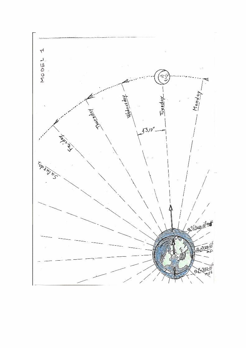
By using our model and arrows of different length it is possible to give a qualitative
gravitational explanation of both the raisings of the water levels in the moon side and in the
opposite.
We note that the numerical differences of the Earth-Moon attraction corresponding to the
three arrows are very little (around one thousandth of the apparent centrifugal acceleration
by which we justify the shape of the Earth) even compared with the “g” acceleration due to
the mass of the Earth.
However such differences explain why the liquid masses at the antipodes are less attracted
and therefore “stay behind” in comparison to the water in front of the Moon.
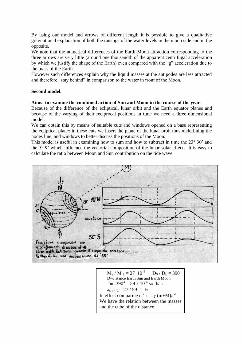
Second model.
Aims: to examine the combined action of Sun and Moon in the course of the year.
Because of the difference of the ecliptical, lunar orbit and the Earth equator planes and
because of the varying of their reciprocal positions in time we need a three-dimensional
model.
We can obtain this by means of suitable cuts and windows opened on a base representing
the ecliptical plane: in these cuts we insert the plane of the lunar orbit thus underlining the
nodes line, and windows to better discuss the positions of the Moon.
This model is useful in examining how to sum and how to subtract in time the 23° 30’ and
the 5° 9’ which influence the vectorial composition of the lunar-solar effects. It is easy to
calculate the ratio between Moon and Sun contribution on the tide wave.
MS / M L = 27 10 5 DS / DL = 390
D=distance Earth Sun and Earth Moon
but 3903 = 59 x 10
5 so that:
as / aL = 27 / 59 ½
In effect comparing 2 r = (m+M)/r
2
We have the relation between the masses
and the cube of the distance.
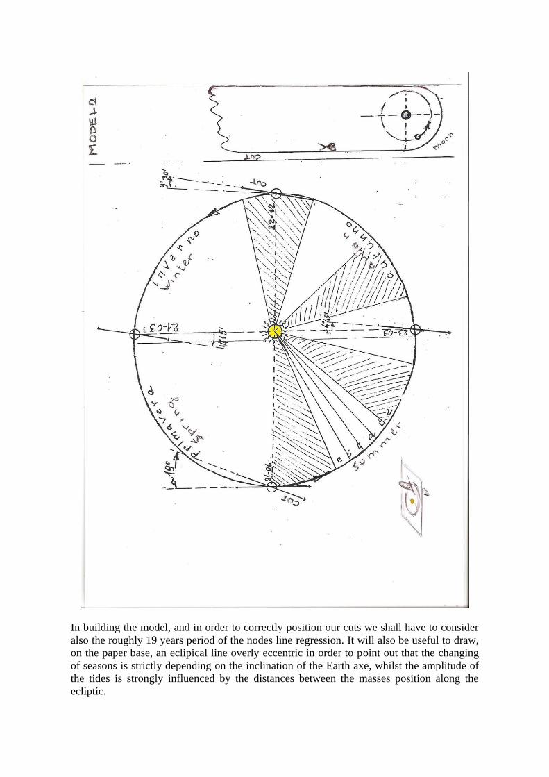
In building the model, and in order to correctly position our cuts we shall have to consider
also the roughly 19 years period of the nodes line regression. It will also be useful to draw,
on the paper base, an eclipical line overly eccentric in order to point out that the changing
of seasons is strictly depending on the inclination of the Earth axe, whilst the amplitude of
the tides is strongly influenced by the distances between the masses position along the
ecliptic.
The tide wave due by two thirds to the Moon and by one third to the Sun shows its
maximum value in the sigizie (when the Moon is opposite or in line with the Sun position).
To confirm all this, you can find data on experimental tables still in use today. See for
instance the hand book of the Everglades fishermen in the South of Florida.
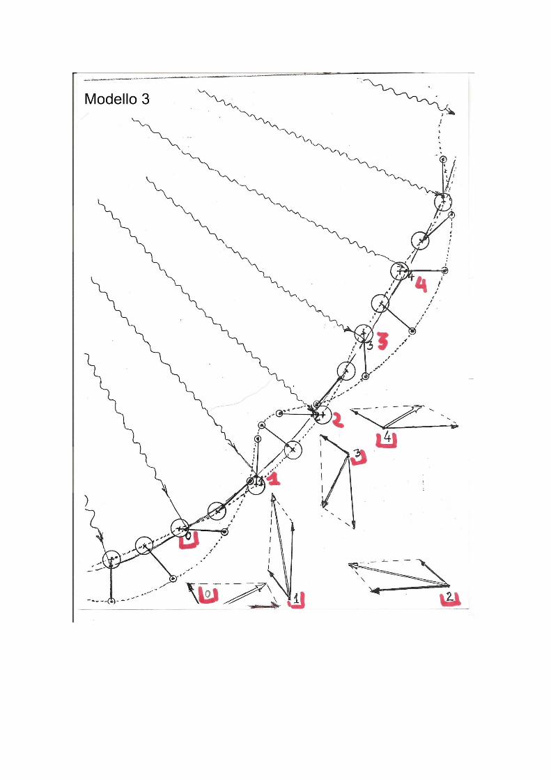
Third model.
Aim: to examine the movement of the Earth-Moon system and its effect on the tides.
Once we construct a handle Earth-Moon, we discuss the successive positions in a simplified
bi-dimensional model during at least four weeks, shifting its barycentre on a wide arch of
ellipse week by week.
This exercise evidences the winding path of the Moon whilst the Earth is only slightly
twisting along the Keplerian ecliptic.
On the same model we can verify the vectorial composition of the gravitational tides-forces
due to the Sun and to the Moon, and we can also use it to study the centripetal forces
caused by the rotation of the handle in different points of the Earth.
Discussion After the students have constructed the models we should discuss the exceptional velocity
of the tide wave that reaches a new maximum after 12 hours in the same place.
There are researches and theories on this problem and we can supply references; here we
limit ourselves to consider the magnitude of the velocity of propagation of the tides
phenomenon at the Equator:
v = equatorial-semi circumference / interval between high tides 6378 / 12 = 1670 Km /h
The research in this sector, thought it does not arrive to describe local situations, has
however been able to build a model of the movement of water masses called “of canals “,
that takes into account the of this phenomenon and the deepness of the ocean.
The high velocity brings us to take into account also the acceleration appearing in non
inertial systems (the situation of a person on the Earth).
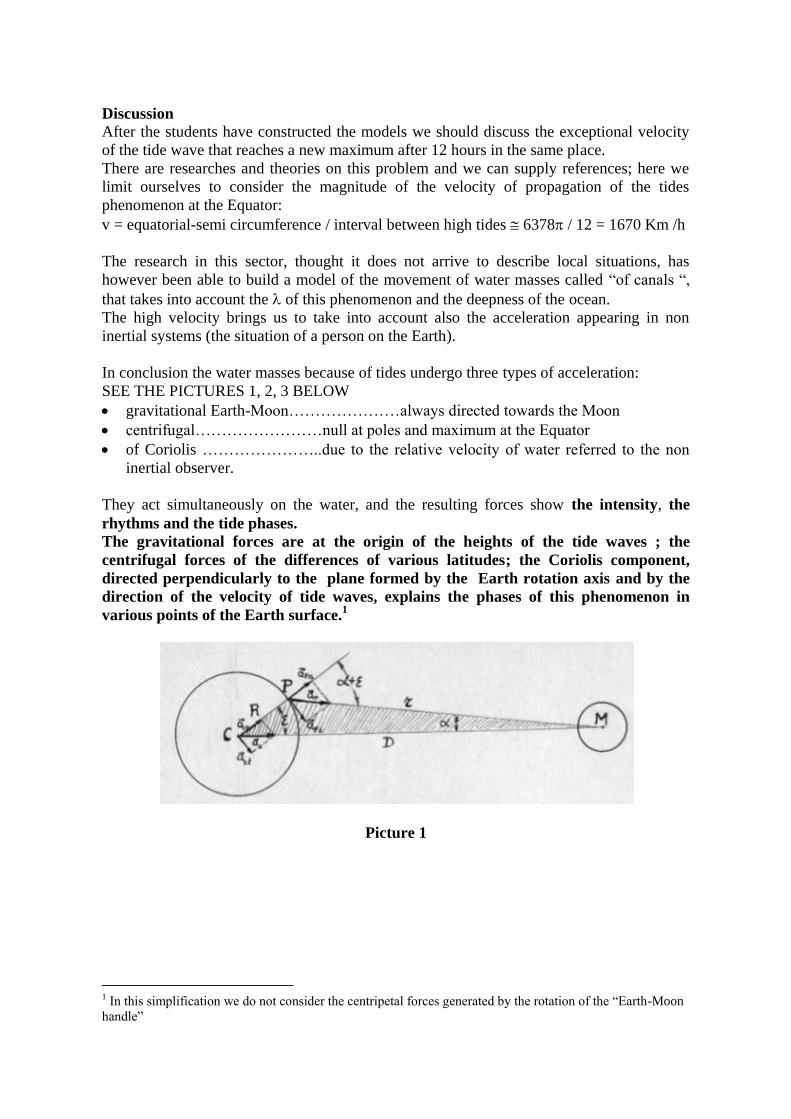
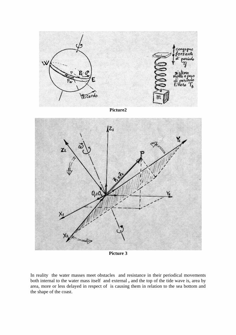
In conclusion the water masses because of tides undergo three types of acceleration:
SEE THE PICTURES 1, 2, 3 BELOW
gravitational Earth-Moon…………………always directed towards the Moon
centrifugal……………………null at poles and maximum at the Equator
of Coriolis …………………..due to the relative velocity of water referred to the non
inertial observer.
They act simultaneously on the water, and the resulting forces show the intensity, the
rhythms and the tide phases.
The gravitational forces are at the origin of the heights of the tide waves ; the
centrifugal forces of the differences of various latitudes; the Coriolis component,
directed perpendicularly to the plane formed by the Earth rotation axis and by the
direction of the velocity of tide waves, explains the phases of this phenomenon in
various points of the Earth surface.1
Picture 1
1 In this simplification we do not consider the centripetal forces generated by the rotation of the “Earth-Moon
handle”
Picture2
Picture 3
In reality the water masses meet obstacles and resistance in their periodical movements
both internal to the water mass itself and external , and the top of the tide wave is, area by
area, more or less delayed in respect of is causing them in relation to the sea bottom and
the shape of the coast.
The phase displacement between the passing of the perturbing celestial body on the local
meridian and the maximum of the tide is called “port hour“. Its knowledge is fundamental
for navigation, but the static theory we have explained cannot take care of this.
By means of the static theory (models 1 and 2) it is possible to correctly evaluate the
amplitude but not the tide phases and even less the “port hours” in various places.
Another topic of discussion is the influence of tides on the duration of the day.
Within the Earth system in the relation to the energy involved in the tide phenomenon, we
can observe that this is a dissipative cycle; in the sense the frictions transform into internal
energy (heat) and into work on the sea bottom and on the coasts a large part of the global
kinetic energy.
The loss of kinetic energy must have caused an extremely slow deceleration of the Earth
rotation. This hypothesis can be verified experimentally only on extremely long times,
unless we can use watches with exceptional resolution.
We have however historical and geological data that confirm its validity.
The very slow deceleration of Earth rotation has allowed the experts to suggest predictions
on a possible future. We shall not follow them in the calculation, but it is stimulating to
note how, basing ourselves on:
The observation of an extension, however very slow, of the duration of a day in the
course of centuries
The simplified hypothesis of a total isolation of the Earth-Moon system
the conviction that in such condition both the total kinetic energy and the total
angular moment must remain constant in time ;
Something changes in the Earth-Moon system as a consequence of the very slow variation
of the distance between the two. In a first hypothesis the moving away of the Moon would
result in its being less linked to the Earth and therefore the tide phenomenon would become
less evident because the height of the tide wave would be only due to the Sun.
In an opposite hypothesis the day would become longer than the lunar month and the Moon
approaching the Earth would be shattered by stronger and stronger forces and would, in the
end, disintegrate.
The most accurate laser measurements seem to confirm that the Earth-Moon distance is
increasing by about 3 cm per year, with a corresponding increase of the lunar period.
FROM A VERY VERY OLD BOOK…
We know how important was for navigation the knowledge of tides to reach a port as well
as to sail in shallow waters. We researched what was the knowledge of tides in the oldest
time, the time of long sailing enterprises and of great discoveries of new lands.
We found a very interesting ancient book, one of the first printed after Gutenberg
discovery, "L'Arte del Navegar"(1555). It is the Italian translation of «Regimento de
Navigacion" composed by Pedro de Medina in 1545 in Sevilla.
For us it has been very involving to get in the way of reasoning about reciprocal positions
of Sun and Moon from a geocentric point of view and to see how great the knowledge
about tides was.
This book was one of the most important treatises in Europe about navigation and in it the
part concerning the tides is widely treated. Here we present a part of the 7th chapter where
it is suggested how to recognise when tides are growing and ebbing. It is interesting to see
the peculiar way by which using the direction of the winds, as you can see in the nice
picture, they arrived to a reference frame useful to indicate the age of the Moon and also the
hour of the day through the position of the Sun.
The overlapping of these two informations gave them the time of a high tide.
They divided the all field of directions in 32 sections (twelve and a half degrees each)
called "rombi".
The book underlines that this rule is available if you use an appropriate counting time
system that is the Roman one so you have at twelve o' clock the Sun in South wind
direction and that at twelve in the night in North wind direction.
As you can see by reading the passages we choose, you can also notice that the old
navigators were aware about the influence on tides of streams, narrow passages, big gulfs
and the presence of a mouth of a great river.
References:
- R. Zambelli - Natura e Scienze Ed Atlas Bergamo 1984;
- proceeding of lectures of prof. Luigi Briatore Didactic Seminaries of Department of
General Physics University of Torino March and November ’96;
- Ancient book “L’Arte del navegar” Translation of “Regimento de navigation…” por
el Maestro Pedro de Medina Sevilla 1545 done by Fra Vincenzo Palatino - Venezia
1554.