Embed Size (px)
Citation preview

“Dig it KingwooD”
San Jacinto River and Lake Houston
Kingwood, TX
2017 - 2018

Devastating Effects of Harvey Flooding in Kingwood
Kingwood Residents & Businesses Demand Solutions!

SJ River
I 69
Target & Costco
Target & Costco
SJ River
I 69
May 24, 2017
August 31, 2017
Major existing & new businesses in the Humble, Kingwood, Atascocita areas are debating their options regarding…… Rebuild vs Relocate?

Perspective on Rainfall Amounts San Jacinto River and Lake Houston Area
Aug 26 – 30, 2017: • 30+ inches of rain
across a large area • Lake level @ 52.5’
May 26 – 28, 2016: • 11.36 inches of rain • Lake level at 47.8’

Somewhat Incorrect Conclusions
• Had excessive rainfall due to Hurricane Harvey
• Due to rain amounts, San Jacinto River & Lake Houston reached historic levels
• High lake level flooded extensive areas of Kingwood
• Lake Conroe releases accelerated the problem
• 500+ year storm conditions that will not happen again
• Rebuild Humble & Kingwood businesses and residential areas
• “Everything will be AOK”

Dig It Kingwood • Kingwood…we have a Problem:
– Massive, new sedimentation deposits along key areas of the San Jacinto River and Upper Lake Houston area near the highly urbanized Kingwood community has contributed to unprecedented flooding events which will only worsen with time.
• The Solution: – Hydrographic surveying and 3D imaging
analysis of the West Fork of the San Jacinto River and upper Lake Houston region in order to accurately define the problem
– Extensive dredging and relocation of the sediment to new areas in order to clear the blockage and help mitigate future flooding concerns
– Eliminate / Restrict the unregulated major sand mining operations occurring along the river
– Partnership between local, state, federal agencies, sand miners, and an experienced dredging vendor with a common goal is a must

River and Lake Sedimentation - Catastrophic Flooding - This is NOT a New Issue

Looking to solve flooding northeast of the city, Councilman Dave Martin will join Mayor Sylvester Turner, members of the city’s Congressional Delegation, and others in a meeting with the U.S. Army Corp of Engineers in Washington. Martin thinks the solution to flooding along the San Jacinto River and around Lake Houston is to dredge the 62-year old lake. “Because of the silt that has gone from various other tributaries that lead into Lake Houston we’ve lost probably about 50% of the holding capacity of the water that sits in Lake Houston,” Martin says. With less room for water in the lake, heavy rains have produced major flooding. Martin believes the cost to dredge the lake could be anywhere from $2-10-billion dollars, and whatever the cost, it will require federal, state and local money. “Anyone who lives in around the Kingwood, Conroe, Huffman and all those areas can look at it, and there is no doubt about it that it’s different today than it ever was,” said Martin. Houston’s recently appointed “Flood Czar” Stephen Costello will also be making the trip to Washington.
“Mayor Turner Heads To DC With Plan For Lake Houston Flooding” July 5, 2016 (U of H – Public Media)

Major Sand Mining Operations on San Jacinto River are DESTROYING the river
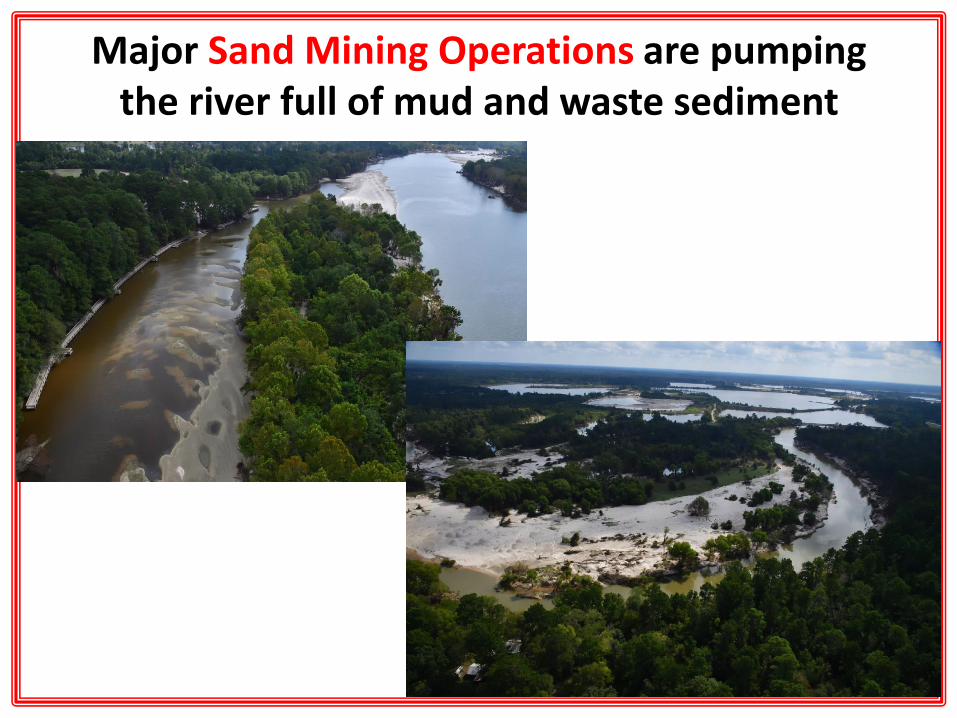
Major Sand Mining Operations are pumping the river full of mud and waste sediment

Lake Conroe San Jacinto River
Lake Houston

Lake Conroe
Lake Houston
San Jacinto River ~32 miles between Lakes
Simple “Road Map” View of the Area Issue is more complex than a simple view

Google Earth Map View of the Area
Lake Conroe
Lake Houston
San Jacinto River Water and Sediment Flow Northwest to Southeast

Lake Houston
San Jacinto River
Lake Houston Localized Watershed Map

Lake Houston True Watershed Map
Lake Houston
Massive drainage area is already heading toward a natural choke point entering Lake Houston.

Lake Houston
Downstream of Lake Houston

Lake Conroe vs Lake Houston

Lake Houston • Created in 1954 with a storage capacity of 158,553 acre-feet • Storage capacity in 2011: 124,661 acre-feet which is 21.4% less than the original capacity • Storage capacity in 2017: Est at < 120,000 acre feet or ~25% reduction over time
“The sedimentation survey indicates sediment accumulation varies throughout the reservoir. Accumulations of sediment are thicker within the natural depressions throughout the reservoir than in the river channels. The heaviest accumulations measured by this survey are between 1.14 and 2.84 miles north of the dam on the western half of the reservoir. TWDB recommends that a similar methodology be used to resurvey Lake Houston in 10 years or after a major flood event.”

Lake Houston vs Lake Conroe
Lake Houston Lake Conroe
Year Built 1954 1973
2010/’11 Storage Capacity 124,661 411,022
Area Covered 11,854 acres 21,000 acres
Water Depth (typ. range) 2’ to 45’ 5’ to 80’
Sedimentation Rate (depth adj.) Rapid Slow
Flooded Residents in Aug 2017 Thousands Zero?

Lake Conroe vs Lake Houston Extremely shallow areas adjacent to Kingwood

Lake Conroe development is on south end of lake in the deeper, non flood prone areas
Kingwood development is on north end of lake in the ultra shallow, flood prone areas
Lake Conroe vs Lake Houston

Lake Conroe Level: • Max of 205.8’ • 5’ above normal • ~2.5% higher • Max on August 27, 2017 • ?? flooded residents
Lake Houston Level: • Max of 52.5’ • 10’ above normal • ~24% higher • Max on August 29, 2017 • Thousands of flooded
residents

West Fork San Jacinto River at I59: • Max of 69.2’ • 27’ above normal • ~65% higher • Max on Aug 29, 2017
Lake Houston Level: • Max of 52.5’ • 10’ above normal • ~24% higher • Max on August 29, 2017
Drone photo Lake Conroe Dam Release – Aug 28th

Lake Conroe 2016 Level: • Max of 204.3’ • 3’ above normal • Max on May 27, 2016 • Zero flooded residents
Lake Houston 2016 Level: • Max of 47.8’ • 5’ above normal • Max on May 29, 2016 • Zero flooded residents?

New Deimos Satellite Imagery

May 24, 2017 August 31, 2017
Lake Conroe Before & After Harvey
Little to no change from flood event

Lake HOUSTON Before & After Harvey
Major Sediment Plug pre-Harvey
Devastating Flood Event Upstream & Downstream

May 24, 2017
August 31, 2017
Major River Sediment Plug
Wide Spread Flooding Event
West Fork of San Jacinto River at Kingwood

Trinity Bay and GOM Before & After Harvey
Massive Sediment Flows

“Kingwood…..we have a Problem”
• Drone view of NEW sediment plugs as of September 15, 2017

W Lake Houston Bridge
Town Center & KWHS
Kingwood Greens
Royal Shores Barrington
Pre-Harvey: Kingwood Target Area

Area 1: Pre-Harvey looking to the west of the West Lake Houston bridge
Area 1: Post-Harvey looking back to the west showing new large sediment plugs and ultra shallow water filled with new mud/sediment.

Entire River complex getting filled with sediment plugs and ultra shallow water depths due west of W. Lake Houston Bridge
W. Lake Houston Bridge

W. Lake Houston Bridge
Entire River complex getting filled with sediment plugs and ultra shallow water
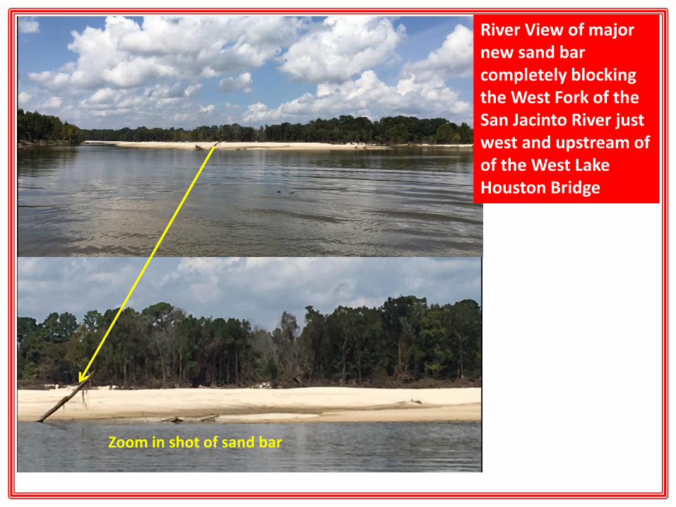
River View of major new sand bar completely blocking the West Fork of the San Jacinto River just west and upstream of of the West Lake Houston Bridge
Zoom in shot of sand bar

People literally walking across the river along the new sand bar. New river blockage and ultra shallow river channel will help to cause MAJOR FLOODING EVENTS in the future.

Entire River complex getting filled with sediment plugs and ultra shallow water
Sediment Plugs will force river to find new pathways during times of extreme rainfall and new flood prone areas will be created

Sediment Plugs serve as “choke points” and will force river to find new pathways during times of extreme rainfall and new flood prone areas will be created
W. Lake Houston Bridge

Major New Residential Developments since 1995
Large Sediment Plugs
Jan 1995
Pre-Harvey 2017

Post Harvey: Major Sediment Plug east of the bridge. Photo shows plug and ultra shallow water covering a very large area

Post Harvey: Major Sediment Plug east of the bridge. Photos shows pre-existing plug getting larger, and ultra shallow water now covering an even larger area

Major new and previously existing sand bars restricting flow along other key areas of the river and entry into Lake Houston, both west and east of the W. Lake Houston Bridge.

Major new and previously existing sand bars restricting flow along other key areas of the river and entry into Lake Houston, both west and east of the W. Lake Houston Bridge.

Area 1: Pre-Harvey River channel west of WLH Bridge

1978
Jan 2017
Sept 2017
Massive amounts of sediment are now covering major areas of the San Jacinto River upstream of Kingwood, and the problem continues to only get worse!

Dec 2002 Dec 1978
Dec 2016 Sept 2017
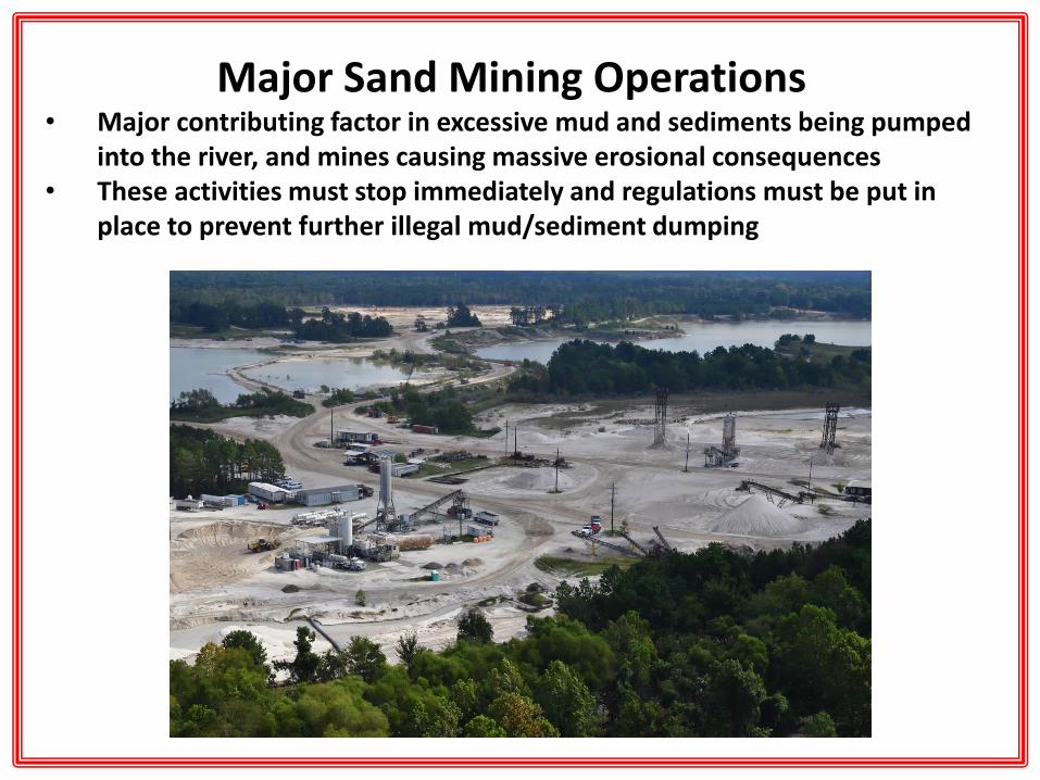
Major Sand Mining Operations • Major contributing factor in excessive mud and sediments being pumped
into the river, and mines causing massive erosional consequences • These activities must stop immediately and regulations must be put in
place to prevent further illegal mud/sediment dumping

• Direct excerpts from Holtcamp article written in June 2006….over 10 years ago!!:

• Excerpts from follow up article in December 2006 in Texas Parks & Wildlife magazine: Although the San Jacinto actually did burn after the 1994 floods caused an oil pipe to burst, this 10-alarm “river
fire” hails from the mining of sand from its bed and banks, and the muddying that has cast a ghostly pall over the river’s once clear, flowing water. In April 2006, American Rivers (a national nonprofit river-conservation group) named the San Jacinto one of the nation’s Most Endangered Rivers.
Though sand mines exist on both sides of the river, earthen levees keep them hidden from our view. The typical Texas sand mine clears riverside land, then gouges sand in deep pits. When finished, nothing regrows because the topsoil has been stripped. Most build their levees only to the annual water line, rather than the 100-year flood plain. Come flood or high water, rains often wash out low levees, emptying the silty water right into the river. Sand mining is not a regulated industry in Texas, unlike in most other states. In other words, so long as they operate on private property, the industry has no regulations to follow, no permits to apply for and no reclamation to complete once finished. But when they affect a public resource — the river — they fall under the jurisdiction of the Clean Water Act.
Aquatic vegetation does not grow well in Lake Houston. In recent months, the City of Houston has dealt with excessive costs for treating Lake Houston drinking water due to taste and odor problems caused by phytoplankton blooms. The lake’s ecosystem is out of whack. Webb’s research found marked differences between ecosystems in Lake Houston and Lake Conroe.
As the river that saw Texas through its revolutionary war and the founding of its largest city, it seems prescient to protect, restore and preserve it — for its value to fish and wildlife and for its importance in providing citizens with clean drinking water and protection from excessive flood damage. Houston has many bayous, but only one river.

All concrete support beams now have extensive, accumulated debris which will also serve to restrict water flowage along the river and entry into the lake along the West Lake Houston Bridge.

Lake Houston Sediment Thickness Map North End near Kingwood

Due to Major Sediment Choke Points
Kingwood Will Not Have a Chance
MAJOR KINGWOOD URBAN AREAS


11 Billion Gallons of Water per HOUR rushing towards MAJOR CHOKE POINTS prevent flowage to Lake Houston

Lake Conroe Dam Release • Drone video • Aug 28th • ~ 2 billion gallons / hour • 2.2x more than previous
record set in 1994
San Jacinto River Gauge at Humble • Aug 27th thru Aug 30th • Level raised from 61’ to over 69’
Any future, massive water releases will further compound the SEDIMENT BUILD UP PROBLEM downstream at identified Kingwood choke points!!

Inaccurate & Misleading Flood Plain Maps

Inaccurate & Misleading Flood Plain Maps due to New Sediment Choke Points

The Solution: Part I • River and Lake Sediment Surveying and 3D mapping with pre &
post-dredging predictive analysis

The Solution Part I: 3D Mapping Project • Map area from I 59 at Humble down San Jacinto River
and upper Lake Houston to the 1960 Bridge • Outlined Area: 6.5 square miles; 4,150 acres • Time to Map: 1-2 months • Estimated Cost: $65,000 • Final analysis needed to design Dredge Project

Major Sand Mining Operations • Parallel with dredging activities, these mining operations must stop immediately
and regulations must be put in place to prevent further illegal mud/sediment dumping, or the dredged areas will fill up once again.

The Solution: Part II • Dredging and Relocation of Sediment Fill

Sediment Plug being dredged out at Mission Lake
in Kansas

Rangers Stadium – Arlington, TX Johnson Creek/Lake
Dredging Project Before and After Photos
Before
After
After


The Solution: Part III • Soil and Sediment Stabilization along the San Jacinto River between Lake Conroe and Lake Houston
• Cement/lime-based solidification is an environmentally sound solution for the management of dredged marine sediments
• Solidified dredged sediments are beneficial for use as a material in road construction. Cement is superior to lime in terms of strength improvement, and adding 6% cement is an economic and reasonable method to stabilize fine sediments.

DIG IT KINGWOOD 12-Month Project Timeline
Q4 2017 Q1 2018 Q2 2018 Q4 2018
Government Awareness *
3D Sedimentation Survey *
Prepare Full Project Report *
Project Funding Secured *
Multi-Faceted Dredging Project * *
River Sediment Stabilization * *

Cars can Stop due to Traffic Jams
River Flood Waters Escape their Boundaries
CHOKE POINTS CAUSE DISASTERS

Since the Kingwood flood of 1994, reports have been written by at least 4 government agencies and Millions of Pages of Reports have been printed…….
and Hundreds of Millions of Dollars have been spent on Kingwood/Humble repairs and rebuilding……
But over this 23 year period, Not a Single Bucket of Sediment mud has been dredged out of the San Jacinto River or Lake Houston…….
Insanity: doing the same thing over and over again and expecting different results.