Embed Size (px)
Citation preview

©DigitalGlobeSurface Engineering Data
PhotoSat | 1-604-681-9770
[email protected] | www.photosat.ca
Maximize the value of existing oil and gas surface engineering and survey data investments
The Challenge As shown in this example from a real project, surveying and other surface engineering location datasets on oil and gas projects are often inconsistent due to different collection times and contractors for each new project work plan. Drilling, completions, and facilities engineers generally re-survey features that may have been surveyed several times already.
Leveraging Existing Survey InvestmentsOn many oil and gas projects there are several hundred thousands of dollars invested in surveying. For a modest investment PhotoSat can reconcile existing oil and gas project location data, including the seismic source and receiver locations, and extend it to a 1m topographic grid accurate to 20cm in elevation. We have invented a process to produce engineering quality topographic surveys from satellite photos.
As shown in the example project, this expansion in the utilization of existing data results in engineering quality surface elevation data for your entire oil and gas project. This new data has the potential to significantly reduce boots on the ground surface scouting and site surveying, streamlining well pad selection and facilities engineering projects.
Upstream Oil and Gas
Image of 5 survey datasets from an oil and gas project. All of these datasets have horizontal or elevation offsets from each other.
Seismic source points,13,730 points
GPS3,13,457 points
Well site
GPS2, 4,040 points
GPS1, 3,669 points

Scatterplot of the elevations of the GPS datasets relative to PhotoSat’s satellite topographic survey, showing elevation offsets of GPS2 and GPS3 from the well location. All three GPS datasets and the seismic data are offset 3.5m horizontally from the well survey.
PhotoSat | 1-604-681-9770
[email protected] | www.photosat.ca
Surface Engineering DataUpstream Oil and Gas
The SolutionPhotoSat has worked with oil and gas companies to develop a highly accurate system for matching engineering datasets to high resolution satellite photos and the derived topographic data.First we determine the relative match between the various datasets and our topographic survey. When we find inconsistencies between them,
we work with your project team to select a reference dataset and shift all others horizontally and vertically to match it. In this example, all other datasets were matched to the well survey. Our process results in matches to within 10cm vertically and 25cm horizontally, and a new reliable elevation dataset for future project work.
Scatterplot of the adjusted elevations of the GPS datasets relative to PhotoSat’s satellite topographic survey. These datasets were also adjusted 3.5m horizontally to match the well survey.
GPS1, 3,669 pointsOffset to well survey3.5m horizontal0m elevation GPS3,13,457 points
Offset to well survey3.5m horizontal1.0m elevation
Well siteGPS2, 4,040 pointsOffset to well survey3.5m horizontal-2.15m elevation
S N
GPS1, 3,669 points
S N
GPS2, 4,040 points
GPS3,13,457 points
Well site

ExperiencePhotoSat has completed over 600 highly accurate topographic surveying projects globally.
We have produced proof-of-accuracy studies, case studies, and demonstration projects which are available on the Experience page of our website.
Surface Engineering DataUpstream Oil and Gas
PhotoSat | 1-604-681-9770
[email protected] | www.photosat.ca
Scatterplot of the elevations of the seismic dataset relative to PhotoSat’s satellite topographic survey, showing a 1.0m elevation offset from the well survey. The seismic data is also offset by 3.5m from the well survey.
Scatterplot of the adjusted elevations of the seismic dataset relative to PhotoSat’s satellite topographic survey, matched to the well survey. The seismic locations were also adjusted 3.5m horizontally to match the well survey.
Well site
Seismic source points, 13,457 pointsOffset to well survey3.5m horizontal1.0m elevation
S N
Well siteSeismic source points, 13,457 points
S N
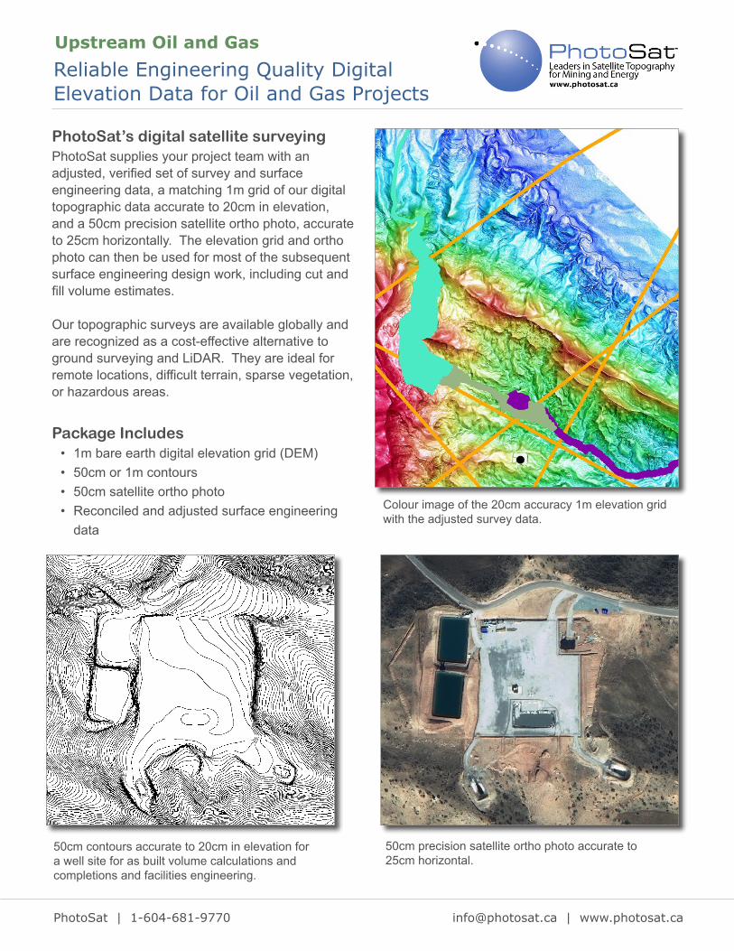
PhotoSat’s digital satellite surveyingPhotoSat supplies your project team with an adjusted, verified set of survey and surface engineering data, a matching 1m grid of our digital topographic data accurate to 20cm in elevation, and a 50cm precision satellite ortho photo, accurate to 25cm horizontally. The elevation grid and ortho photo can then be used for most of the subsequent surface engineering design work, including cut and fill volume estimates.
Our topographic surveys are available globally and are recognized as a cost-effective alternative to ground surveying and LiDAR. They are ideal for remote locations, difficult terrain, sparse vegetation, or hazardous areas.
Reliable Engineering Quality Digital Elevation Data for Oil and Gas Projects
Upstream Oil and Gas
Colour image of the 20cm accuracy 1m elevation grid with the adjusted survey data.
PhotoSat | 1-604-681-9770
[email protected] | www.photosat.ca
Package Includes• 1m bare earth digital elevation grid (DEM)• 50cm or 1m contours• 50cm satellite ortho photo• Reconciled and adjusted surface engineering
data
50cm contours accurate to 20cm in elevation for a well site for as built volume calculations and completions and facilities engineering.
50cm precision satellite ortho photo accurate to 25cm horizontal.