Embed Size (px)
Citation preview
DirectionIntegratedSystemsCompany
Direction integrated systems is a private joint stock company
established under the law of companies of the Republic of Sudan
1925 and is listed under the law of companies
registrationwithGeneral Commercial registrar under the number
(36284).
CompanyAddress:
Republic of Sudan - Khartoum Al Marat - the intersection of 29t
Street with Mohammed Najib Street.
Tel: 249-154882010 Fax: 249-154882040
Website:www.direction-sd.com
E-mail :[email protected]
The Company's goals:
The country has seen a renaissance of development in various
technical fields. And to meet these new advancements and future
challenges,an expansion in use of the latest technologies that save
time and effort becomesverycrucial. So came the idea of creating a
specialized company with clear strategic objectives
toprovidetechnical support to keep pace with technological
developments in Sudan, not to overlook the technical implementation
of key activities and associated activities of the company.
Company's activities:
1. Working in the field of engineering consultancy.
2. Work in the field of electrical and civil engineering.
3. Working in the field of surveying and maps. (Where the
company officially qualified by the Ordnance Survey).
4. Security and safety systems and information security.
5. The company works in the computer fields (maintenance,
programming, networks).
6. Designing specializedprograms for companies and institutions,
security programs in particular.
7. Working in the field of mineral exploration (mechanical,
Geophysical).
8. Working in the field of seismic survey.
9. Working in the field of mining (where the company owns the
name Direction for mining, Al Fares mining)
10. Working in the field Removal rocky obstacles with regard to the
work of water and oil.
11. The company holds internal and external courses for
geographic information systems ,Comuter and Information
security and confidentiality systems.
12. GIS consulting and Designing Services : consulting sevices to
help design spatial database , applications and systems to
meet customer needs in geographic information systems.
13. GIS data conversion and Automation.
14. Spatial analysis: (Spatial Analysis) our team is able to assist in
the spatial analysis process that helps in the decision-making
process.
15. Tracking (Tracking): Direction Integrated Systems provides
integrated tracking and tracing of vehicles and personnel
services or assets.
16. Navigation Services (Navigation Services) to access and
navigate effectively from one point to another, thanks to the
visual guidance or voice, as the system will reset the roads
depending on the applications of Geolocation GPS for joint
According geographical maps, which include side streets and
major in the provinces, as well as the main places "points of
Interest" in the state of Khartoum.
17. Remote Sensing applications:Digital image processing (Digital
Image Processing): Modeling, Enhancement, analysis of
variance (Contrast), Mosaicking .
18. Safety and Security: The Company markets alarming and fire
extinguishing systems,manual or automated.
Bodies that deals with the company:
1. Armed Forces (Communication and Information Commission,
the Military Survey Department, etc.).
2. Ministry of the Interior (central reserves, Civil Registry
Authority, Authority police supply).
3. Governmental institutions.
4. Sudanese company for the distribution of electricity (where
the company officially qualified by the Sudanese company for
the distribution of electricity).
5. Ministry of Electricity and Dams Implementation Unit.
6. The Ministry of Communications (National Information Center).
7. Ordnance Surveyof Khartoum state(where the company
officially qualified by the body).
8. The Ministry of Infrastructure and Urban Development.
9. General Authority of Civil Aviation.
10. Central Bureau of Statistics.
11. Commission to encourage investment.
12. National Water Corporation.
13. Companies that work in the Implementation of roads and
bridges
14. Working in the field of transportation and relocation
companies.
15. Petro Lowell Petroleum Services.
16. Al Mutakamla Chemicals and development Co.Ltd.
17. Security guards companies.
18. Car rental companies.
19. KM Technology Corporation
20. White Nile Sugar factory.
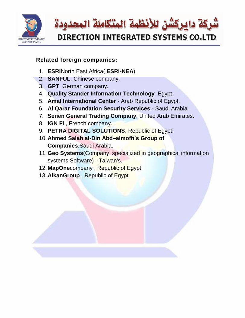
Related foreign companies:
1. ESRINorth East Africa( ESRI-NEA).
2. SANFUL, Chinese company.
3. GPT, German company.
4. Quality Stander Information Technology ,Egypt.
5. Amal International Center - Arab Republic of Egypt.
6. Al Qarar Foundation Security Services - Saudi Arabia.
7. Senen General Trading Company, United Arab Emirates.
8. IGN FI , French company.
9. PETRA DIGITAL SOLUTIONS, Republic of Egypt.
10. Ahmed Salah al-Din Abd–almofh’s Group of
Companies,Saudi Arabia.
11. Geo Systems(Company specialized in geographical information
systems Software) - Taiwan's.
12. MapOnecompany , Republic of Egypt.
13. AlkanGroup , Republic of Egypt.
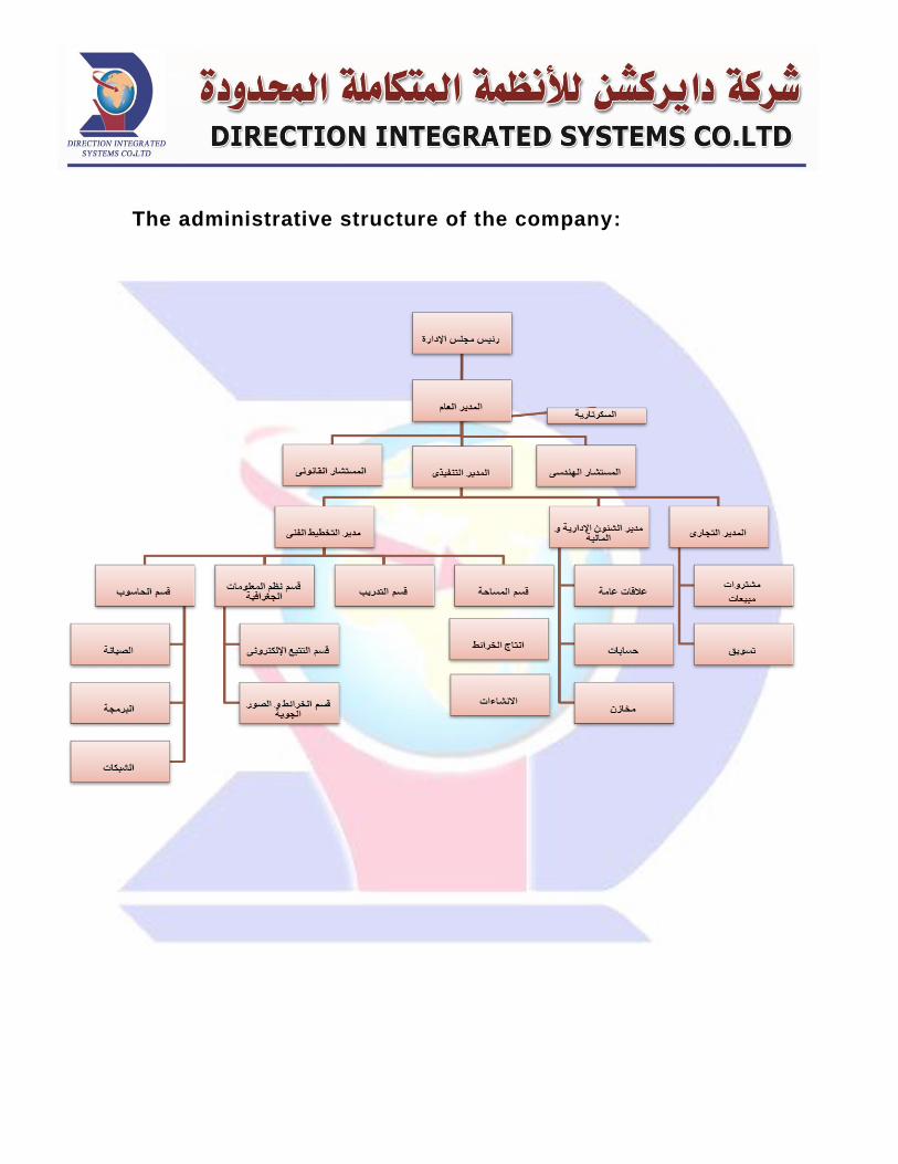
The administrative structure of the company:
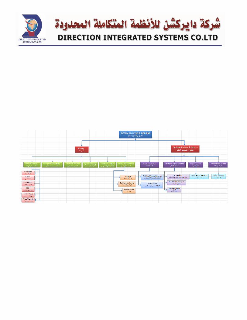

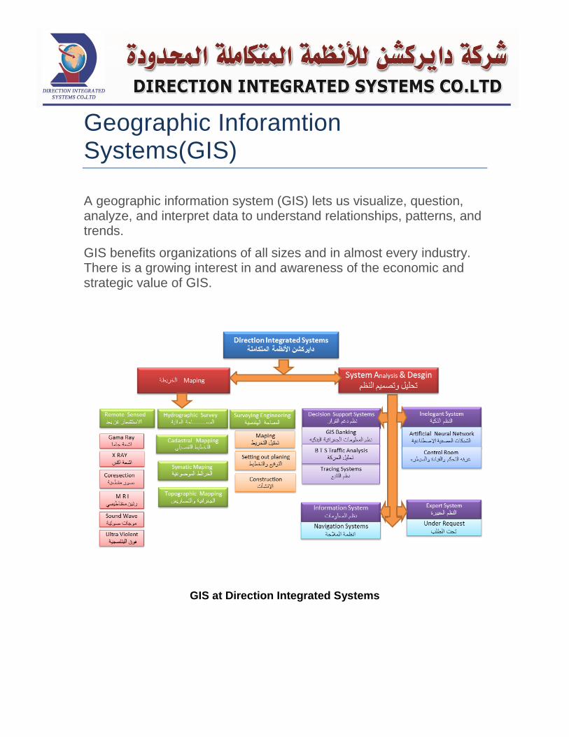
Geographic Inforamtion Systems(GIS)
A geographic information system (GIS) lets us visualize, question, analyze, and interpret data to understand relationships, patterns, and trends.
GIS benefits organizations of all sizes and in almost every industry. There is a growing interest in and awareness of the economic and strategic value of GIS.
GIS at Direction Integrated Systems
Why GIS?
GIS is widely used to optimize maintenance schedules and daily fleet movements. Typical implementations can result in a savings of 10 to 30 percent in operational expenses through reduction in fuel use and staff time, improved customer service, and more efficient scheduling. GIS helped the City of Woodland refine its fleet scheduling, saving fuel and labor
Better Decision Making: GIS is the go-to technology for making better decisions about location. Common examples include real estate site selection, route/corridor selection, evacuation planning, conservation, natural resource extraction, etc. Making correct decisions about location is critical to the success of an organization. This GIS-based disaster decision support system helps Taiwan plan for and respond to typhoons
Cost Savings from Greater Efficiency :GIS-based maps and visualizations greatly assist in understanding situations and in
storytelling. They are a type of language that improves communication between different teams, departments, disciplines, professional fields, organizations, and the public.
Better Record Keeping :Many organizations have a primary responsibility of maintaining authoritative records about the status and change of geography. GIS provides a strong framework for managing these types of records with full transaction support and reporting tools. ROI on Montana's GIS-based statewide cadastral system is more than $9 million annually.
COMPONENTSOF A GIS:
An operational GIS also has a series of components that combine to make the system work. These components are critical to a successful GIS.
Hardware
Hardware is the computer system on which a GIS operates. Today, GIS software runs on a wide range of hardware types, from centralized computer servers to desktop computers used in stand-alone or networked configurations.
Software
GIS software provides the functions and tools needed to store, analyze, and display geographic information. A review of the key GIS software subsystems is provided above.
Data
Perhaps the most important component of a GIS is the data. Geographic data and related tabular data can be collected in-house, compiled to custom specifications and requirements, or occasionally purchased from a commercial data provider. A GIS can integrate spatial data with other existing data resources, often stored in a corporate DBMS. The integration of spatial data (often proprietary to the GIS software), and tabular data stored in a DBMS is a key functionality afforded by GIS.
People
GIS technology is of limited value without the people who manage the system and develop plans for applying it to real world problems. GIS users range from technical specialists who design and maintain the system to those who use it to help them perform their everyday work. The identification of GIS specialists versus end users is often critical to the proper implementation of GIS technology.
Methods
A successful GIS operates according to a well-designed implementation plan and business rules, which are the models and operating practices unique to each organization.
As in all organizations dealing with sophisticated technology, new tools can only be used effectively if they are properly integrated into the entire business strategy and operation. To do this properly requires not only the necessary investments in hardware and software, but also in the retraining and/or hiring of personnel to utilize the new technology in the proper organizational context. Failure to implement your GIS without regard for a proper organizational commitment will result in an unsuccessful system ! Many of the issues concerned with organizational commitment are described in Implementation Issues and Strategies.
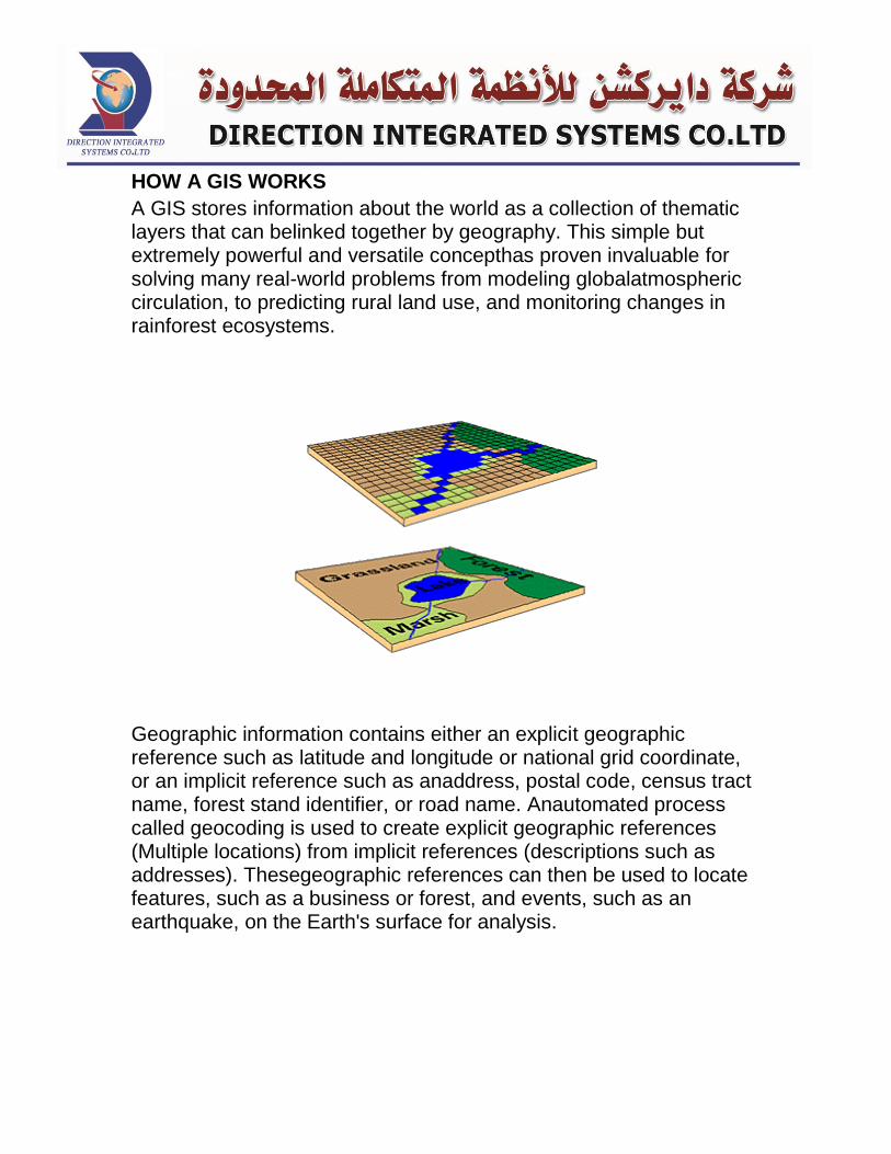
HOW A GIS WORKS
A GIS stores information about the world as a collection of thematic layers that can belinked together by geography. This simple but extremely powerful and versatile concepthas proven invaluable for solving many real-world problems from modeling globalatmospheric circulation, to predicting rural land use, and monitoring changes in rainforest ecosystems.
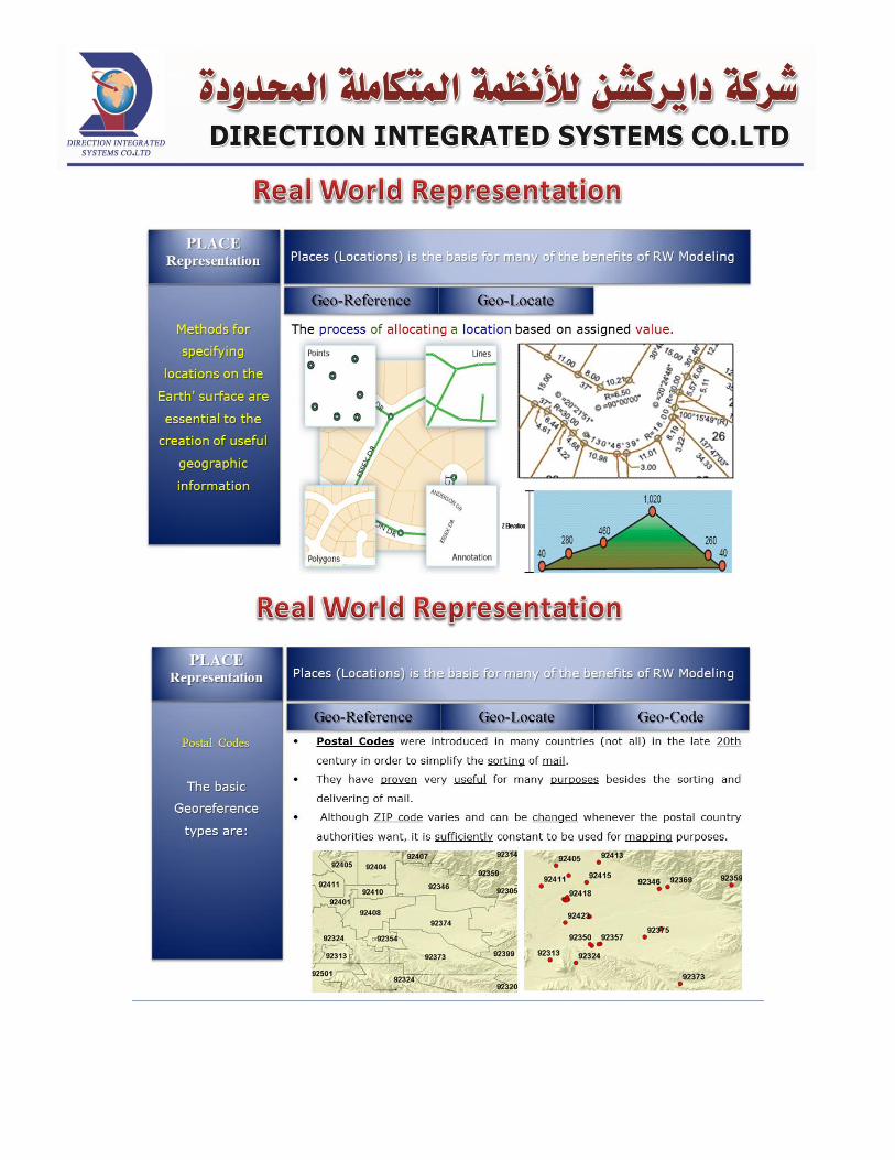
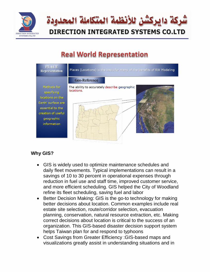
Geographic information contains either an explicit geographic reference such as latitude and longitude or national grid coordinate, or an implicit reference such as anaddress, postal code, census tract name, forest stand identifier, or road name. Anautomated process called geocoding is used to create explicit geographic references (Multiple locations) from implicit references (descriptions such as addresses). Thesegeographic references can then be used to locate features, such as a business or forest, and events, such as an earthquake, on the Earth's surface for analysis.
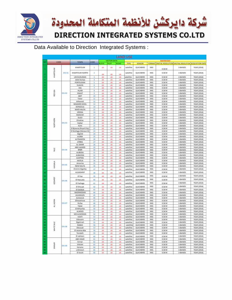
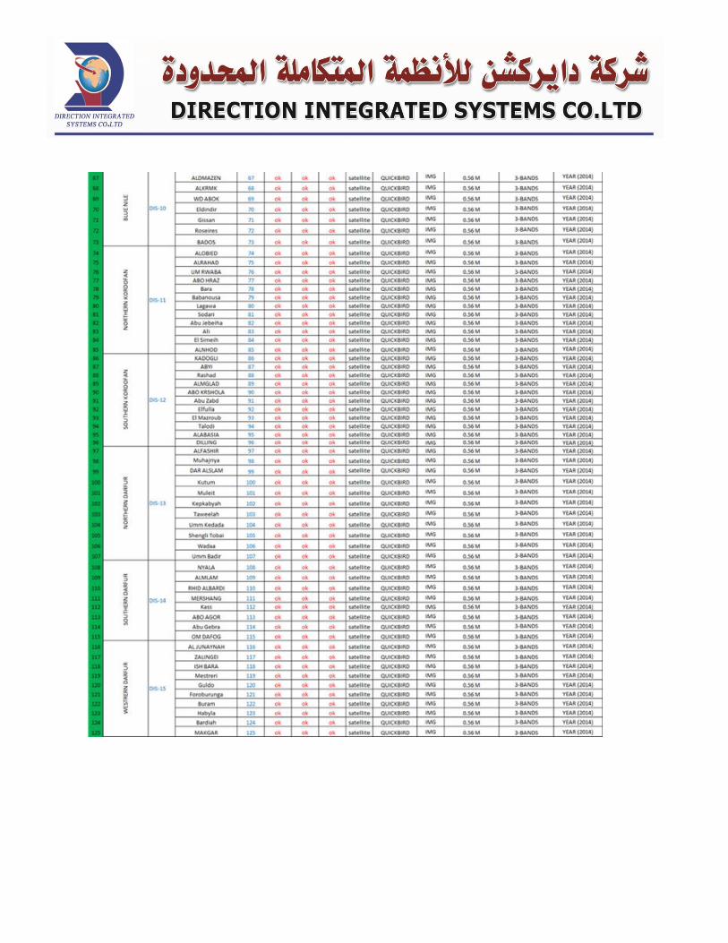
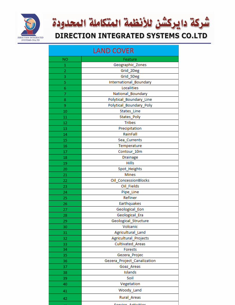
Data Available to Direction Integrated Systems :
Navigation
The Global Positioning System (GPS) is a space-based satellite
navigation system that provides location and time information in all
weather conditions, anywhere on or near the Earth where there is an
unobstructed line of sight to four or more GPS satellites.
Navigation system provides you with following information
when you drive your car :
Smarter destination search: search for the location you want to
visit.
Time remaining to reach your destination.
Quick and intelligent routing and rerouting.
Integration with contacts (and possibly social networks).
Excellent spoken voice features.
A voice command system that works and works well.
A connection to the Web/cloud.
A cohesive interface that's not distracting to the driver.
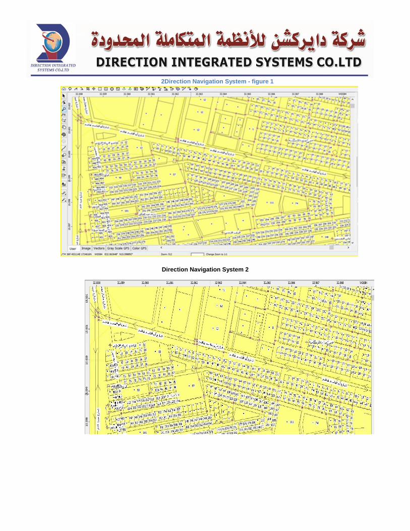
2Direction Navigation System - figure 1
Direction Navigation System 2
Vehicles tracking system
With Full pride Direction Integrated Systems Co. Ltd. developed
its automatic tracking system forvehicles.
Introduction:
Many companies have a huge departments require
them to provide a means for workers to transport goods , such as
sales departments and othertechnical departments responsible for
customer service, these departments have great share in maximizing
the company's profits and play a important role in customer
satisfaction.
Despite this fact ,senior management understands the
importance of maintaining the productivity rates of these
departments, they sometimes ignores the importance of the transport
fleet management serve these departments in order to achieve higher
productivity rates at the lowest possible cost.
The companies that rely on fleets of transport as one of the
main instruments governing the conduct of the work depends upon
such distribution companies are supposed to have sufficient expertise
to manage its own fleet of transport by employees where bother
appointing of them experience in the organization of work and the
fleet.
However, this does not apply to most of the companies that
deal in selling a commodity, market, or maintenance depending on
the means of transport owned, as here, the company is required to
offer this service to work on own and operate vehicles to help those
who work in the implementation of their duties and here consists fleet
management problem transport in non-specialized companies with
access to higher productivity management concerned at the lowest
cost transfer is not easy and helping the difficulty of this matter is that
the nature of the transportation costs in itself it cost does not
centralized and diverse in the sense that the cost is repeated often
and in amounts small in a variety of geographic areas, which
incalculable traditional methods.
Hence it is clear that the transport fleet is a work tools such as
production or computer to machines administration and the process
of binding policies put each company's departments will ensure
monitoring and control the actions of employees to manage this fleet
and staff by established policies allowing access to the operating
efficiency of the transport fleet and provide cost desired helping both
those who work for senior management in achieving their goals....
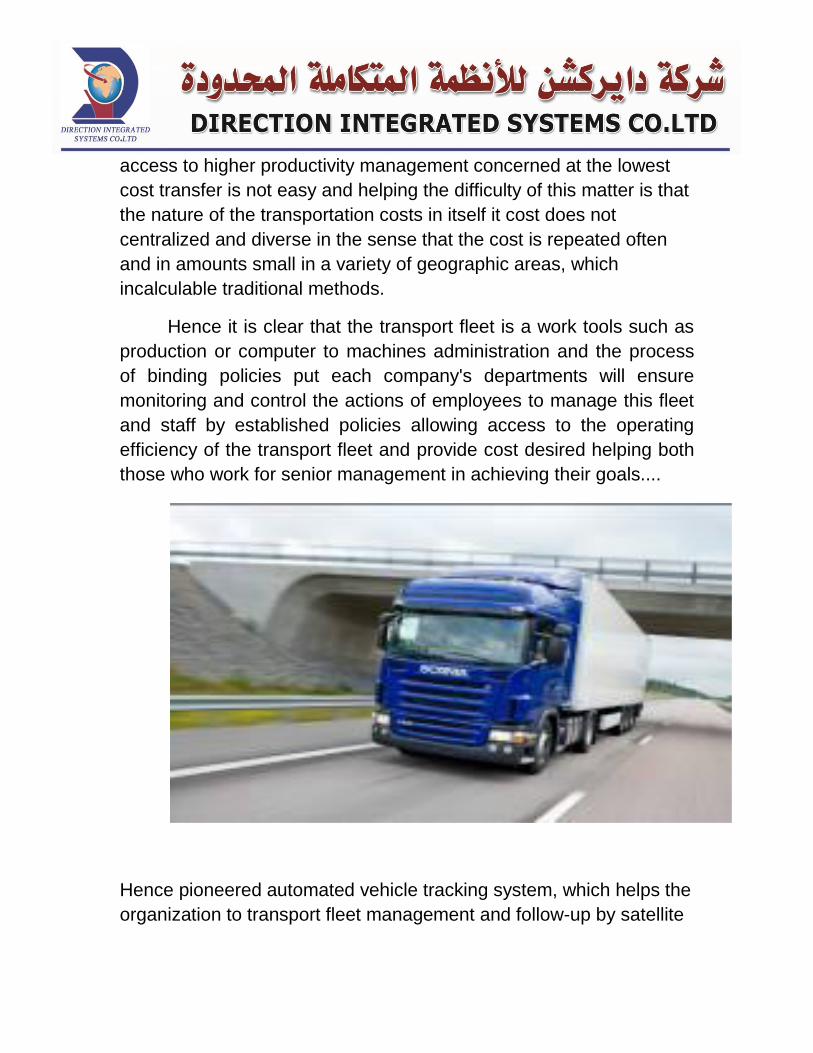
Hence pioneered automated vehicle tracking system, which helps the
organization to transport fleet management and follow-up by satellite
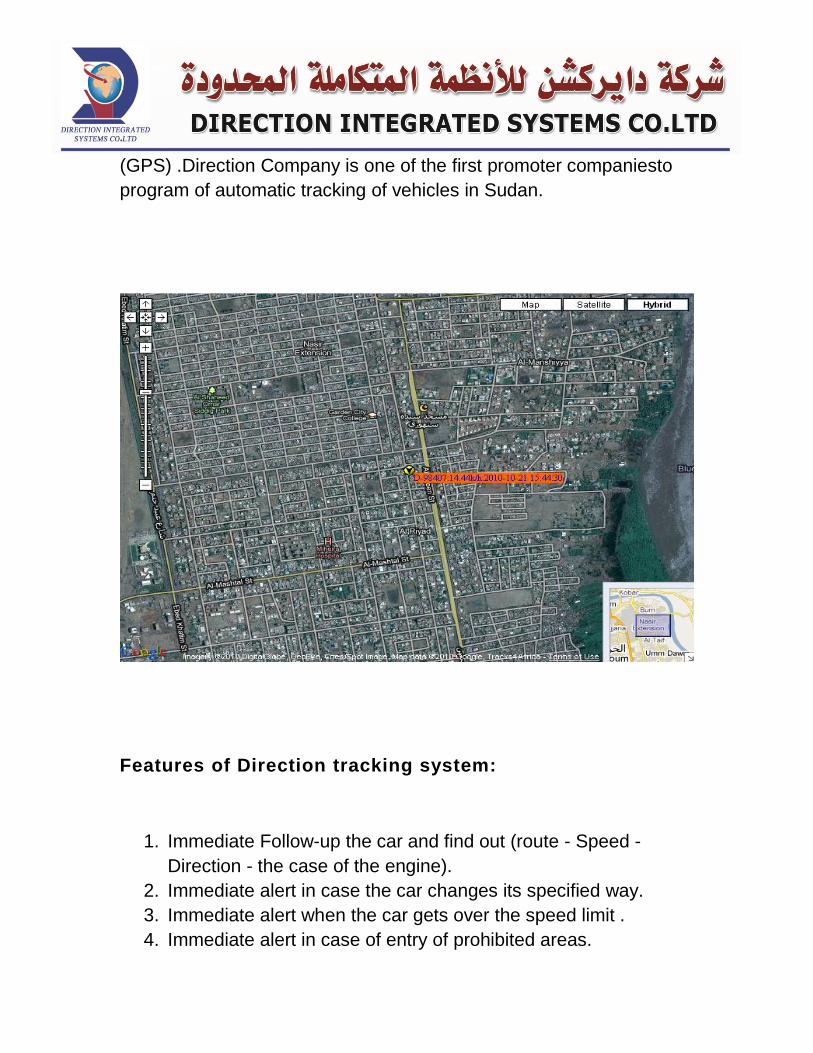
(GPS) .Direction Company is one of the first promoter companiesto
program of automatic tracking of vehicles in Sudan.
Features of Direction tracking system:
1. Immediate Follow-up the car and find out (route - Speed -
Direction - the case of the engine).
2. Immediate alert in case the car changes its specified way.
3. Immediate alert when the car gets over the speed limit .
4. Immediate alert in case of entry of prohibited areas.
5. Contact the driver at any time to help or guidance.
6. The possibility of stopping the car engine.
7. Possibility of following-up of more than a car at a time.
8. Possibility of defining and identifying clients on the map easily.
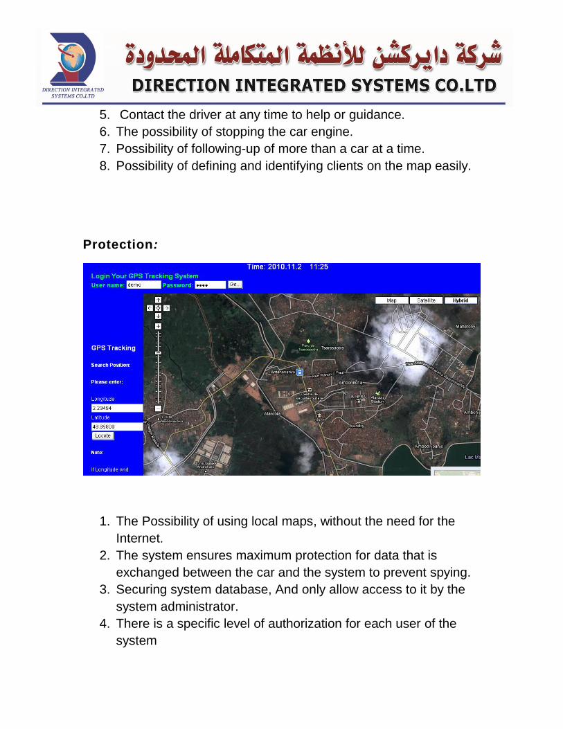
Protection:
1. The Possibility of using local maps, without the need for the
Internet.
2. The system ensures maximum protection for data that is
exchanged between the car and the system to prevent spying.
3. Securing system database, And only allow access to it by the
system administrator.
4. There is a specific level of authorization for each user of the
system
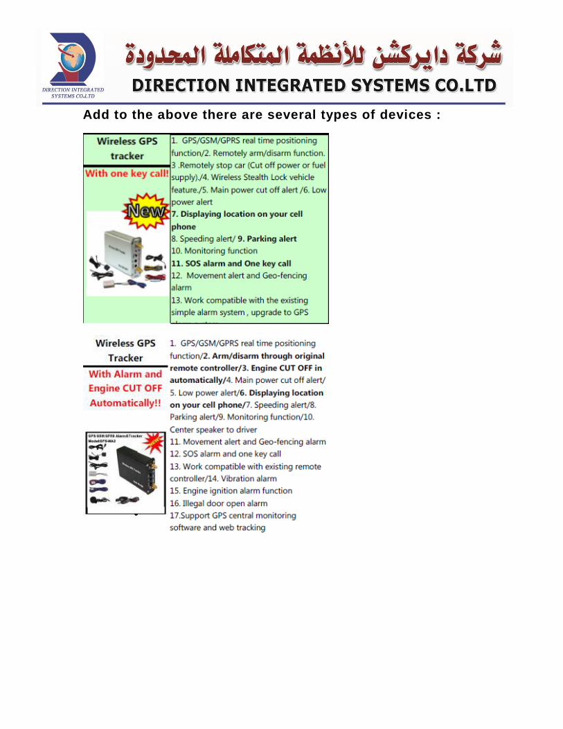
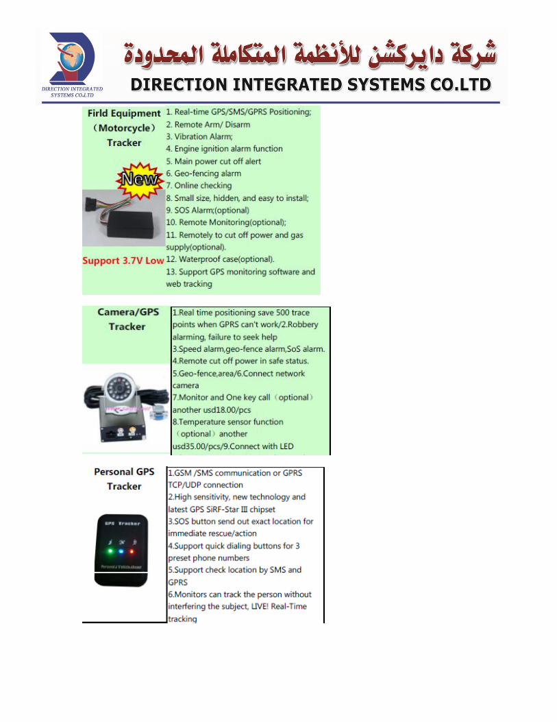
Add to the above there are several types of devices :
Survey Works
Geodetic Survey.
Cadastral Survey.
Contour Maps.
Control Survey.
Route Survey.
Topographic Survey.
Subdivision Survey.
Site Plan Survey.
GPS Real Time (RTK).
Survey Works
• • • • • • • • • GPS Real Time • • • • • • •
GIS
GIS and LIS Surveying and Mapping
Digital Image Processing
Satellites imageries
Applications:-
GPS Tracking Systems.
Vehicle Tracking Systems.
Applications Tracking Systems
Survey Works
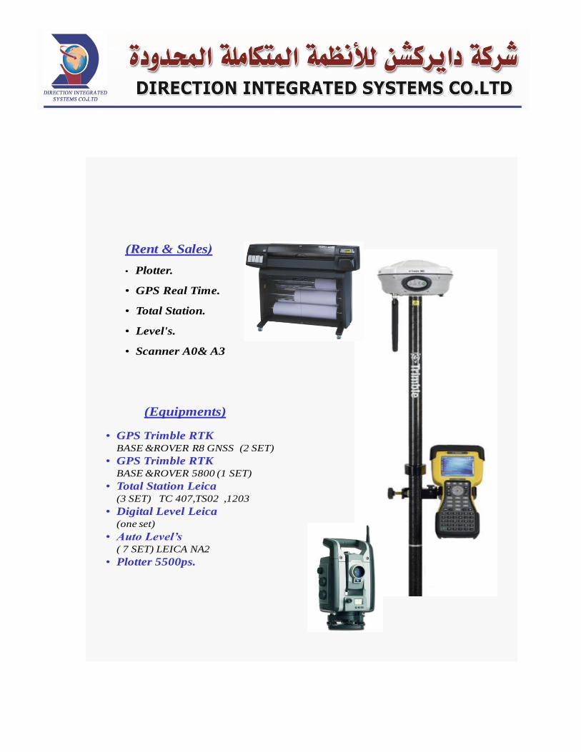
• GPS Trimble RTKBASE &ROVER R8 GNSS (2 SET)
• GPS Trimble RTKBASE &ROVER 5800 (1 SET)
• Total Station Leica(3 SET) TC 407,TS02 ,1203
• Digital Level Leica(one set)
• Auto Level’s( 7 SET) LEICA NA2
• Plotter 5500ps.
(Equipments)
Rent & Sales(
• Plotter.
• GPS Real Time.
• Total Station.
• Level's.
• Scanner A0& A3
Route Survey
Reconnaissance, preliminary survey and location survey for an alignment or linear type feature
such as a road, railroad, canal, pipeline or utility line.
Geodetic Survey
A Land Survey which is affected by and takes into account the curvature of the earth and
astronomic observations.
Topographic Survey
A Land Survey locating natural and man made features such as buildings, improvements, fences,
elevations, land contours, trees, streams, etc. This type of survey may be required by a government
agency, or may be used by Engineers and/or Architects for the design of improvements or
developments on a site.
Control Survey
A Land Survey providing precise locations of horizontal and vertical positions of points for use in
boundary determination, mapping for aerial photographs, construction staking, or other needs.
GIS and LIS Surveying and Mapping
Geographic Information Systems and Land Information Systems.
Satellites imageries
All type of satellites images in the most recent resolutions.
LANDDESK TOP 2004-2009
LANDDESKTOP&EARTH WORK
ArcGIS 9.3, ERDAS 9.2,ENVI & IDRISI
4WD

Fire Fighting System
Saving lives is the primary consideration when fire breaks
down in buildings, and therefore people inside the building need
to be informed so they canevacuatethe building quickly as possible
before the fire spreads out. And therefore should be the means of
notifying system inside the buildings.The primary task of any warning
system is to record and the discovery of fire and transform it into
an electrical signal that operates the alarm, then the fire alarm
system sends electrical impulses to control panel which in
turn creates immediately light signal ; indicates where the sound is
coming from, and it also create a sound signal to be heard by the
responsible person . the master control panel for the existence of
the fire. Must be buildings must be equipped warnings systems
and basics firefighting facilities to protect buildings and their
occupants from the dangers of fire, by providing early warnings
in order to evacuate the building , and firefighting primarily by
trained personnel or by Automatic equipment and then call the Civil
Defense team if necessary.
Fire alarm systems and equipment are divided into thefollowing
main types:
Manual fire alarm systems
Automatic fire alarm systems
First: Manual fire alarm systems:
The break glass call point is a device to enable personnel to raise the
alarm in the event of a fire, by simply breaking a frangible element
and thus activating the alarm system.
The following notes give guidance for the correct siting and
positioning of break glass call points:
1. Break glass call points should be located on exit routes
and in particular on the floor landings of staircases and at
all exits to the open air.
2. Break glass call points should be located so that no
person need travel more than 45m from any position
within the premises in order to give an alarm (30m if
layout is unknown).
3. Generally, call points should be fixed at a height of 1.4m
above the floor, at easily accessible, well-illuminated and
conspicuous positions free from obstruction.
4. The method of operation of all call points in an
installation should be identical unless there is a special
reason for differentiation.
5. Manual and automatic devices may be installed on the
same system although it may be advisable to install the
manual call points on separate zones for speed of
identification.
Second:Automatic Fire Detection and Alarm Systems
Automatic fire detection and alarm systems are designed to warn building occupants of a fire situation, they do not generally intervene in the fire growth process except where interfaced with a fire suppression or other fire control system.
These systems generally use smoke, heat or flame detectors to detect the outbreak of fire and to alert building occupants and the fire brigade. Manual call points which allow an occupant who discovers fire to raise the alarm may also be included in the system..
Single station residential smoke alarms, as installed in most homes, are the simplest system for detecting a fire and warning the building occupants.
The time between the outbreak of fire and the commencement of firefighting is the single most important factor in fire control and can be effectively reduced by having the system monitored directly by the fire brigade.
Fire alarm systems must be heard by the building occupants in all parts of the building. To achieve this, they are often connected to occupant evacuation warning and intercommunication systems which sound a defined "beep - beep - beep" throughout the building when the detection system has been activated.
Sometimes these systems automatically close smoke and fire doors, operate flashing warning lights, stop air-conditioning systems or alert critical staff via personal pagers. Today these systems extensively rely upon computer systems and are changing at the same rapid pace as is computer technology. Today's systems can be "intelligent" defining exactly where the fire is, determining if the smoke is from a fire threat or just burnt toast and advising the maintenance manager when the detector needs cleaning or other routine maintenance work is required.The parts that make up the automatic warning system are:
Detectors sensitive heads is of two types :
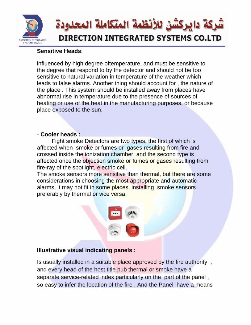
Sensitive Heads:
influenced by high degree oftemperature, and must be sensitive to the degree that respond to by the detector and should not be too sensitive to natural variation in temperature of the weather which leads to false alarms. Another thing should account for , the nature of the place . This system should be installed away from places have abnormal rise in temperature due to the presence of sources of heating or use of the heat in the manufacturing purposes, or because place exposed to the sun.
- Cooler heads : Fight smoke Detectors are two types, the first of which is
affected when smoke or fumes or gases resulting from fire and crossed inside the ionization chamber, and the second type is affected once the objection smoke or fumes or gases resulting from fire-ray of the spotlight, electric cell. The smoke sensors more sensitive than thermal, but there are some considerations in choosing the most appropriate and automatic alarms, it may not fit in some places, installing smoke sensors preferably by thermal or vice versa.
Illustrative visual indicating panels :
Is usually installed in a suitable place approved by the fire authority ,
and every head of the host title pub thermal or smoke have a
separate service-related index particularly on the part of the panel ,
so easy to infer the location of the fire . And the Panel have a means
to experience the connections for the system to make sure the
integrity and validity, and some of these panels have a means to
clarify the false alarm caused by faulty connectionsto the system.
Audible Warning Devices :
Such as bell and whistle , and the voice of warning must be clear and
audible within the building or in a designated portion of the building.
Audible warning device may not be appropriate in some
placeswithspecial status , such as hospitals and department stores
because it leads to panic among people inside the building , and
therefore , the sound of warning device should be heard only in the
control room and the audible warning device should be replaced with
light warning device , which gives light signals in fire situation , until
all the workers know the place where the fire occurred and take
appropriate action or evacute the building in an orderly manner .
calling the fire specialists :
calling fire fighter is an important step after hearing the warning
device so they can control the situation . and this can be done by
installing a direct line between control room of civil defense and the
place where fire breaks out.
Wires and other connections for the system:
Wires used in warning system should conform to the standards and
approved by the technical official , it’s also necessary to have two
sources of electricity for warning device ,electricity mainstreamas
primary source , and Batteries as secondary source to ensure the
warning system works in all circumstances .
Testing and maintenance of alarm system :
Must ensure on ongoing basis the safety and validity of the
warning system and the adequacy of electricity resources
feeding the warning system .. and testing the at regular
intervals . be sure to inform the building occupants before
the testing .
Checking system installation by the technicians in this
business and should test the validity of the batteries of the
warning system at regular intervals and writing the test result
in its own notebook.
Care must be taken for Detector heads for the following :
o Don’t cover the Detector head under the ceiling with
any type of cover , Paint , for example so as not to
lose its sensitivity .
o Put a protector around the detector head to protect it
from shacks or anything unusual but not affect its
sensitivity .
Facts concerns Automatic warning System :
Ceiling Height:
When ceiling height exceeds 10 ft., heat detector
spacing must be reduced. Early detection of smoldering fires
with spot-type smoke detectors installed on high ceilings
(greater than fifteen feet, for instance) is nearly impossible. A
fire plume has an inverted cone shape; as the fire intensifies,
smoke and hear rises and the cone angle narrows. The fire
plume becomes almost nonexistent where there is a smoldering
fire. The smoldering fire is difficult to detect because there is no
flame or heat to drive the combustion products to the ceiling.
Once the fire intensifies, the combustion products will be driven
to the detector, however, detection at this time could hardly be
called early warning.
Air Conditioning:
HVAC effects on air flow and air stratification should
be determined and considered when planning detector
placement. In rooms where forced-air ventilation is present,
detectors should not be located where air from supply diffusers
could dilute smoke before it reaches the detector. This may
require additional detectors, because placing detectors only
near return air openings may leave the balance of the area with
inadequate protection, especially when the HVAC system is not
operating.
False alarms:
False alarms are also common with smoke , heat detectors and
building fire alarm systems. They occur when smoke detectors are
triggered by smoke that is not a result of a dangerous fire. Weather
high temperatures , Smoking cigarettes, cooking at high
temperatures, burning baked goods, blowing out large numbers of
birthday candles, or taking showers at high temperatures near a
smoke detector can all be causes of these false alarms. False alarms
can be avoided by installing less sensitive smoke detectors so as not
to be affected by normal operation conditions .
Computer
1. Maintenance:
Desktop Computermaintenance.
Laptop computers maintenance.
Printing equipment.
Maintenance of photocopiers.
Offers to provide periodic maintenance.
Delivery of Services to the workshop.
2. Networks:
Installation and maintenance of networks (wire / wireless).
Providing networking devices. (Access point / switch /
cables / card / etc.)
3. Computer and accessories:
Computers (PC / Laptop)
Computer accessories provide keyboard / mouse / flash /
etc.))
Computer operating systems. (Windows XP / 7/8 / vista /
2000)
4. Programming:
Using Oracle programming language. (Oracle / Oracle SQL)
Programming using Visual Basic language. (Visual basic)
5. Softwares :
Corporate governance system.
Pharmacy management system.
Restaurantand cafeterias management systems.
Personnel administration. (Human resource) .

POS Management. (Point of sale) .