Embed Size (px)
Citation preview
Bundesamt für LandestopografieOffice fédéral de topographieUfficio federale di topografiaFederal Office of Topography
www.swisstopo.ch
2003
Conventional signs
and further information
to the topographic maps
Swiss topographic maps
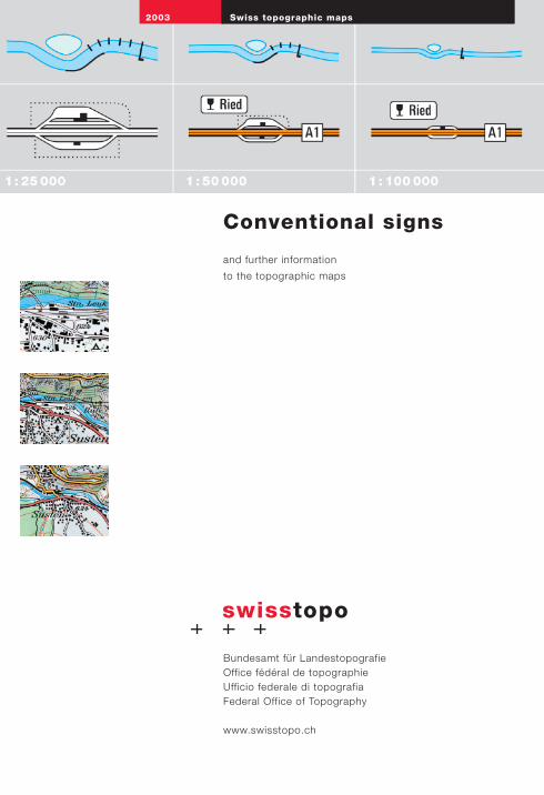
Roads, tracks
Highway (divided lanes)Junction under construction
Rest areaParking
2nd cl. highway (undivided lanes)Exit / Access under construction
Trunk road Main connecting road
1st cl. road (at least 6 m wide) conspicuous bridge
2nd cl. road (at least 4 m wide) conspicuous bridge
Suburban road (at least 4 m wide) conspicuous bridge
3rd cl. road (at least 2.8 m wide) covered bridge
4th cl., narrow road (at least 1.8 m) Bridge
5th cl., path, trail, bicycle path Footbridge, catwalk
6th cl., footpath Passenger ferry, attachedfree
Traces, mountain passage on glacier
Barrier, traffic ban
conspicuous roundabout Parking lot
Level crossings
Underpasses
Overpasses
Tunnels Ventilation shaft
Gallerie
Parklane Tank road
Traces of historic road
Airport, hard surface runwayAirfield, grass strip
National boundary with numbered markers
Cantonal boundary with markers
District boundary with markers
Municipal boundary with markers
Boundary for National Park or protected area
Boundaries
1: 25 000 1: 50 000 1:100 000

Railways
Topography
1: 25 000 1: 50 000 1:100 000
Railway station, tracks Platform roof
Stop with separate track
Stop without separate track
Normal gauge railway: multiple tracks Bridge
Normal gauge railway: single track Bridge
Narrow gauge railway: multiple tracks Bridge
Narrow gauge, rack, cable railway:single track Bridge
Freight or nostalgic railwayRailway out of service Bridge
Intercommunal tramwaywith stop Bridge
Industrial track Bridge
Tunnels
Galleries
Aerial cable way, chairliftwith intermediate station PylonGoods lift Pylon
Skilift
Contour lines earth, scree / shingle, ice / lake
Index contours earth, scree / shingle, ice / lake
Intermediate contours earth, scree / shingle, ice / lake
Small depression Doline
Escarpment, earth Escarpment, stone
Cutting Embankment
Earth slip Gravel pit
Clay pit Quarry
Rock Scree
Glacier Moraine
10 m (Jura Mtns., Plateau)20 m (Alps) 20 m 50 m
100 m 200 m 200 m
5 m / 10 m 10 m 25 m
Rock with 100 m contour lines
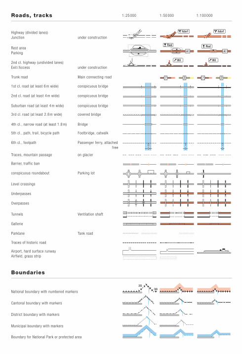
Vegetation
Trigonometric points, spot heights
Individual symbols 1: 25 000 1: 50 000 1:100 000
House Ruin
Remote inn Tower
Greenhouse Storage tank
Allotment (garden) Monument
Church Chapel
Cemetery Shrine, cross
Cooling tower Wind power station
Chimney-stack Castle
Lookout tower Radio transmitter
large antenna small antenna
Camp site Summer toboggan-run
Sports ground Stadium
Rifle range
Race course (horses)
Border of an area Golf course
Ski jump dry wall
Wall Avalanche barricade
Cave, grotto erratic bloc
Trigonometric points 1st to 3rd order and LV95
Spot height
Index contour
Lake level Spot height at lake bottom
Forest, defined outline undefined outline
Scattered forest isolated tree / group of trees
Scrub Hedge
Orchard Tree nursery
Vineyard
only Pyramids
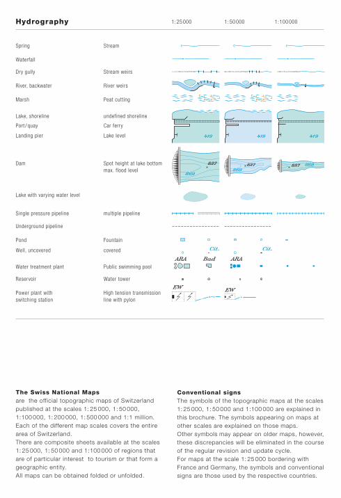
Hydrography 1: 25 000 1: 50 000 1:100 000
Spring Stream
Waterfall
Dry gully Stream weirs
River, backwater River weirs
Marsh Peat cutting
Lake, shoreline undefined shoreline
Port / quay Car ferry
Landing pier Lake level
Dam Spot height at lake bottommax. flood level
Lake with varying water level
Single pressure pipeline multiple pipeline
Underground pipeline
Pond Fountain
Well, uncovered covered
Water treatment plant Public swimming pool
Reservoir Water tower
Power plant with High tension transmissionswitching station line with pylon
The Swiss National Mapsare the official topographic maps of Switzerlandpublished at the scales 1: 25 000, 1: 50 000,1:100 000, 1: 200 000, 1: 500 000 and 1:1 million.Each of the different map scales covers the entirearea of Switzerland.There are composite sheets available at the scales1: 25 000, 1: 50 000 and 1:100 000 of regions thatare of particular interest to tourism or that form ageographic entity.All maps can be obtained folded or unfolded.
Conventional signsThe symbols of the topographic maps at the scales1: 25 000, 1: 50 000 and 1:100 000 are explained inthis brochure. The symbols appearing on maps atother scales are explained on those maps.Other symbols may appear on older maps, however,these discrepancies will be eliminated in the courseof the regular revision and update cycle.For maps at the scale 1: 25 000 bordering withFrance and Germany, the symbols and conventionalsigns are those used by the respective countries.
ARA Bad ARA
EW EW
A. Alp
Bl.err. Bloc erratic
CAS Club Alpin Svizzer
Cna Camona
Cum. Cumün, Cumegn
F. Fuorcla, Furcla
Fda Fermeda, Fermada
Funt. Funtauna
Lav. Lavinar, Laviner
Mgna Muntogna, Muntagna
OE Ouvra electrica
Osp. Ospidel, Ospedel
P. Piz, Pez
Rna Ruina
S. San, Son, Sogn, Sontg
Sar. Sarinera
Ser. Serenera
Stn Staziun
Vad. Vadret
Vscha Vischnanca,Vschinaunca
Clos du Doubs G i b e l e g g w a l d
Surselva Val Malvaglia Chummertälli
Jungfrau Rosablanche Poncione di Braga
Passo del San Gottardo Col de la Croix Fuorcla Surlej
LE RHÔNE Limmat Verzasca Ova Chamuera
LAGO MAGGIORE Lac de Morat Lej da Segl
Aletschgletscher Vadret Pers Gh. dei Cavagnoli Gl. de Darbonneire
BERN GENÈVE ZÜRICHLUGANO CHUR SION
Sumvitg Biasca BuochsCressier (NE) Sagogn Corippo
Cassarate Bruggen Le Sentier
Champƒèr Carasso Mürren
Le Plan Clavaniev Nante
Tri‡thütte SAC La Râpette A. Naucuola
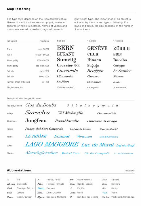
Examples of other topographic names
Regions, Forests
Valleys
Mountains
Passes
Rivers
Lakes
Glaciers
Map lettering
Abbreviations rumantsch
The type style depends on the represented feature.Names of municipalities are set upright, names ofsuburbs or hamlets in italics. Names of valleys andmountains are set in medium, regional names in
light weight type. The importance of an object isindicated by the size and type of lettering. Fortowns and cities, the size depends on the numberof inhabitants.
Settlement Population 1: 25 000 1: 50 000 1:100 000
Town over 50 000
Town 10 000 – 50 000
Municipality 2000 –10 000
Municipality less than 2000
Suburb over 2000
Suburb 100 – 2000
Hamlet, group of houses 50 –100
Single house, hut
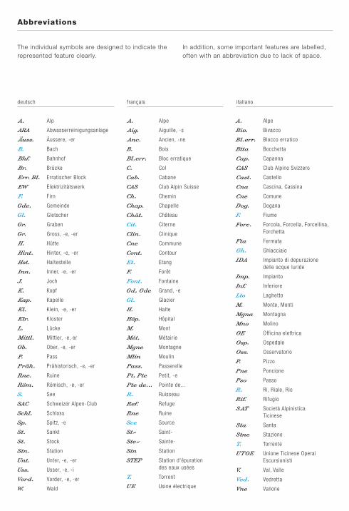
deutsch français italiano
A. Alp
ARA Abwasserreinigungsanlage
Äuss. Äussere, -er
B. Bach
Bhf. Bahnhof
Br. Brücke
Err. Bl. Erratischer Block
EW Elektrizitätswerk
F. Firn
Gde. Gemeinde
Gl. Gletscher
Gr. Graben
Gr. Gross, -e, -er
H. Hütte
Hint. Hinter, -e, -er
Hst. Haltestelle
Inn. Inner, -e, -er
J. Joch
K. Kopf
Kap. Kapelle
Kl. Klein, -e, -er
Klr. Kloster
L. Lücke
Mittl. Mittler, -e, er
Ob. Ober, -e, -er
P. Pass
Präh. Prähistorisch, -e, -er
Rne. Ruine
Röm. Römisch, -e, -er
S. See
SAC Schweizer Alpen-Club
Schl. Schloss
Sp. Spitz, -e
St. Sankt
St. Stock
Stn. Station
Unt. Unter, -e, -er
Uss. Usser, -e, -i
Vord. Vorder, -e, -er
W. Wald
A. Alpe
Aig. Aiguille, -s
Anc. Ancien, -ne
B. Bois
Bl.err. Bloc erratique
C. Col
Cab. Cabane
CAS Club Alpin Suisse
Ch. Chemin
Chap. Chapelle
Chât. Château
Cit. Citerne
Clin. Clinique
Cne Commune
Cont. Contour
Et. Etang
F. Forêt
Font. Fontaine
Gd, Gde Grand, -e
Gl. Glacier
H. Halte
Hôp. Hôpital
M. Mont
Mét. Métairie
Mgne Montagne
Mlin Moulin
Pass. Passerelle
Pt, Pte Petit, -e
Pte de... Pointe de...
R. Ruisseau
Ref. Refuge
Rne Ruine
Sce Source
St- Saint-
Ste- Sainte-
Stn Station
STEP Station d'épurationdes eaux usées
T. Torrent
UE Usine électrique
A. Alpe
Biv. Bivacco
Bl.err. Blocco erratico
Btta Bocchetta
Cap. Capanna
CAS Club Alpino Svizzero
Cast. Castello
Cna Cascina, Cassina
Cne Comune
Dog. Dogana
F. Fiume
Forc. Forcola, Forcella, Forcellina,Forchetta
Fta Fermata
Gh. Ghiacciaio
IDA Impianto di depurazione delle acque luride
Imp. Impianto
Inf. Inferiore
Lto Laghetto
M. Monte, Monti
Mgna Montagna
Mno Molino
OE Officina elettrica
Osp. Ospedale
Oss. Osservatorio
P. Pizzo
Pne Poncione
Pso Passo
R. Ri, Riale, Rio
Rif. Rifugio
SAT Società AlpinisticaTicinese
Sta Santa
Stne Stazione
T. Torrente
UTOE Unione Ticinese Operai Escursionisti
V. Val, Valle
Ved. Vedretta
Vne Vallone
Abbreviations
The individual symbols are designed to indicate therepresented feature clearly.
In addition, some important features are labelled,often with an abbreviation due to lack of space.

Terrestrial photograph

Digital orthophoto «SWISSIMAGE»
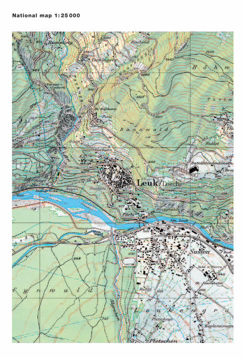
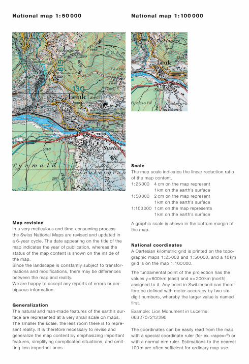
National map 1: 25 000
National map 1: 50 000
Map revisionIn a very meticulous and time-consuming processthe Swiss National Maps are revised and updated ina 6-year cycle. The date appearing on the title of themap indicates the year of publication, whereas thestatus of the map content is shown on the inside ofthe map.Since the landscape is constantly subject to transfor-mations and modifications, there may be differencesbetween the map and reality.We are happy to accept any reports of errors or am-biguous information.
GeneralizationThe natural and man-made features of the earth’s sur-face are represented at a very small scale on maps.The smaller the scale, the less room there is to repre-sent reality. It is therefore necessary to revise andgeneralize the map content by emphasizing importantfeatures, simplifying complicated situations, and omit-ting less important ones.
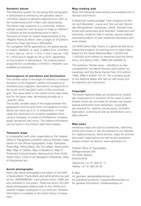
ScaleThe map scale indicates the linear reduction ratioof the map content.1: 25 000 4 cm on the map represent
1 km on the earth’s surface1: 50 000 2 cm on the map represent
1 km on the earth’s surface1:100 000 1 cm on the map represents
1 km on the earth’s surface
A graphic scale is shown in the bottom margin ofthe map.
National coordinatesA Cartesian kilometric grid is printed on the topo-graphic maps 1: 25 000 and 1: 50 000, and a 10 kmgrid is on the map 1:100 000.
The fundamental point of the projection has thevalues y = 600 km (east) and x = 200 km (north)assigned to it. Any point in Switzerland can there-fore be defined with meter-accuracy by two six-digit numbers, whereby the larger value is namedfirst.
Example: Lion Monument in Lucerne:666 270 / 212 290
The coordinates can be easily read from the mapwith a special coordinate ruler (for ex. «rapex»®) orwith a normal mm ruler. Estimations to the nearest100 m are often sufficient for ordinary map use.
National map 1:100 000
Geodetic datumThe reference system for surveying and cartographyin Switzerland is defined by the geodetic datum«CH1903» based on Bessel’s ellipsoid from 1841 atthe fundamental point in Bern (old observatory).The Swiss map projection is a conformal, obliquecylinder projection with its point of origin (y = 600 km /x = 200 km) at the fundamental point in Bern.The point of origin for height measurements is the«Repère Pierre du Niton» with a height of 373.600 mabove the mean sea level in Marseilles.For navigation (GPS) applications, the global geode-tic datum «WGS84» is used. It differs from «CH1903»in the y-axis by –50 to –110 m, in the x-axis by –130to –160 m and in height by 45 to 53 m, dependingon the location in Switzerland. The transformationprograms for coordinates («CH1903» /«WGS84») areavailable at swisstopo.
Convergence of meridians and declinationThe variable value of the angle of westerly or easterlydeviation of the magnetic needle (convergence ofmeridians plus magnetic declination) corresponds tothe south-north line (grid north) of the coordinategrid. The value refers to the center of the map sheetand for the given year, decreasing annually by a–specific value.The locally variable value of the angle between thegeographic and the grid north (convergence of meri-dians) can reach up to 2° in Switzerland. In mostcases the declination is currently negligible whenusing a compass. In zones of interference, however,larger deviations may occur. The relative informationcan be found in the bottom right-hand margin.
Thematic mapsIn cooperation with other organizations, the FederalOffice of Topography publishes various thematic mapsbased on the official topographic maps. Examples:Road Map, Hiking Maps, Ski Tour Maps, MunicipalityMap, Map of Castles, Map of Museums, Map ofProtected Cultural Assets, Aeronautical Chart ICAO,Glider Chart, Chart of Air Navigation Obstacles, Atlasof Switzerland etc.
Aerial photographsEach year aerial photographs are taken of one sixthof Switzerland. These black-and-white photos as wellas the «SWISSIMAGE» color photos (since 1998) arealso available to the public. There are about 350,000aerial photographs (dating back to the 1920s) andsatellite images catalogued in our archives. Detailedinformation is available at the photo library of swiss-topo.
Map-reading aidsNote: the following three articles are available only inGerman and French.
A didactical media package “Vom Umgang mit Kar-ten und Geodaten - Laure und Tom auf den Spurendes Röstigrabens” (swisstopo, 2002). Student note-books with excercises (and teachers’ notebooks withsolutions), media kit (free if rented), special websitewww.laureundtom.ch with additonal information andwork sheets.
CD-ROM Swiss Map Trophy is a game as well as aninteractive program for learning how to read maps,based on the Swiss National Map 1: 25 000 and1: 200 000 (joint edition by swisstopo and the SwissArmy, 2nd edition 2001, ISBN 302-060909-4).
The textbook “Karten lesen - Handbuch zu denLandeskarten” by Martin Gurtner (joint edition byswisstopo and the Swiss Alpine Club, 2nd edition1998, ISBN 3-85902-137-0). The complete guideto the National Maps with tips for self-study andfor teachers and instructors.
CopyrightThe Swiss National Maps are protected by federallaw. Duplications or revisions of the maps or partsthereof which are not solely for private use requirespecial permission from swisstopo. Copyrightsare required for: reprints, photocopies, microfilm,digitization, scanning as well as distribution over adata network.
Map salesswisstopo maps are sold by bookstores, stationerystores and kiosks or can be ordered on our website.For digital products, aerial photos, maps for schoolsand youth organizations as well as any questions,please contact us directly. www.swisstopo.ch
Federal Office of TopographySeftigenstrasse 264CH-3084 Wabern (Switzerland)
Telephone +41 31 963 21 11Telefax +41 31 963 24 59
E-Mail:for geodata: [email protected] published products: [email protected] general information: [email protected]