Embed Size (px)
Citation preview

`
1
Working Paper Series No. 4 | April 2015
© Resilience Development Initiative
Disaster Impacts and Children Welfare in West Java Province, Indonesia
Elisabeth Rianawati
Resilience Development Initiative
Saut Sagala
Institute of Technology Bandung, School of Architecture, Planning and Policy Development
Alpian A. Pratama
Resilience Development Initiative

`
2
WP No : 4
Date : April, 2015
Resilience Development Initiative (RDI) is a think tank initiative based in Bandung, Indonesia that focuses on environmental change and sustainable development. RDI contributes to the body of knowledge on development and disaster research studies in Indonesia and South East Asian Region.
RDI Working Paper Series is published electronically by RDI.
The views expressed in each working paper are those of the author or authors of the paper. They do not necessarily represent the views of RDI or its editorial committee.
Citation of this electronic publication should be made in Harvard System of Referencing.
Editorial Team:
Elisabeth Rianawati
M Wahyu Anhaza Lubis
Dr. Saut Sagala
Contact:
Address: Jalan Imperial II No. 52, Bandung 40135 Jawa Barat – INDONESIA
Phone: +62 22 2536574 Email: [email protected]
Website: www.rdi.or.id
`
3
Disaster Impacts and Children Welfare in West Java Province, Indonesia*
Elisabeth Rianawati1, Saut Sagala2, Alpian A. Pratama1
1Resilience Development Initiative Bandung
2Institute of Technology Bandung, School of Architecture, Planning and Policy Development
Bandung
Corresponding author: [email protected]
Abstract
Children are one of the groups exposed to the impact of natural disasters. Natural disasters can cause fatalities and injuries in children, as well as disruption of teaching and learning activities. Natural disasters can mainly affect children under the age of growth 'golden age', aged 0 to 5 years. At the time of this rapid growth, interference or obstacles that occur in long-term growth can result into adulthood. Interference or obstacles that may occur during this growth may be due to hunger, malnutrition, stress and diseases that occur due to natural disasters. The impact of this natural disaster has been felt by most of the children in Indonesia, which is a country with a high risk of natural disasters. In fact, children are the future generation who will determine the well-being of the country's competitiveness. In addition, children are the largest population in the country. Unfortunately, studies that measure the impact of natural disasters on children in Indonesia are still few. Therefore, this study has a high urgency and immediate, to fill in the gaps of knowledge in terms of the impact of disasters on children, as one of the vulnerable groups. This research study location is in West Java with a case study in Bandung regency and Garut. West Java itself has experienced catastrophic impact of the earthquake, flood and drought. Bandung Regency also has high levels of economic growth and high population, which will trigger the vulnerability of the population, including children. Thus, from this research the disaster impact on children well-being will be mapped out.
Keywords:
Children; Disaster Impact; Vulnerability
1. Introduction
Disaster gives various impacts to a community, in terms of physical, psychological, economic and material. Natural disasters will cause casualties and damage, be it fatalities, injuries, damage to private and public facilities, as well as induces refugees who are generally susceptible to the disease. It impacts the whole community, particularly the vulnerable groups such as elderly, disables and children. Disaster will leave the community in conditions of communities around the affected area after the disaster will usually be in paralyze state due to the infrastructure damage or possession loss that the people suffer. Children and young people represent 30 percent of the world population, making them as the largest group of people currently affected by natural disasters. Children also have a higher susceptibility than adults. This is because the children are in the process of physical development and cognitive, so physically and mentally, they have a lower capacity to handle the consequences caused by climate change and disasters, such as food shortages, loss or stress so that the risk of such exposure is more have a long-term impact on the life of the child.
*The full work of this chapter is published in the book “Masyarakat Tangguh Bencana, Pendekatan Sosial Ekonomi, Tata Kelola dan Tata Ruang.” Chapter 3.3, 1st Edition. Editor: Herryal Z. Anwar. LIPI, 2015
`
4
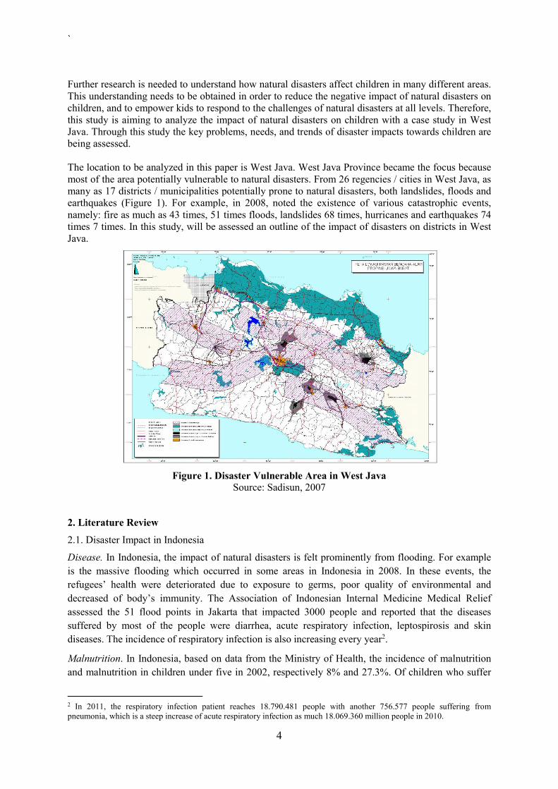
Further research is needed to understand how natural disasters affect children in many different areas. This understanding needs to be obtained in order to reduce the negative impact of natural disasters on children, and to empower kids to respond to the challenges of natural disasters at all levels. Therefore, this study is aiming to analyze the impact of natural disasters on children with a case study in West Java. Through this study the key problems, needs, and trends of disaster impacts towards children are being assessed. The location to be analyzed in this paper is West Java. West Java Province became the focus because most of the area potentially vulnerable to natural disasters. From 26 regencies / cities in West Java, as many as 17 districts / municipalities potentially prone to natural disasters, both landslides, floods and earthquakes (Figure 1). For example, in 2008, noted the existence of various catastrophic events, namely: fire as much as 43 times, 51 times floods, landslides 68 times, hurricanes and earthquakes 74 times 7 times. In this study, will be assessed an outline of the impact of disasters on districts in West Java.
Figure 1. Disaster Vulnerable Area in West Java Source: Sadisun, 2007
2. Literature Review
2.1. Disaster Impact in Indonesia
Disease. In Indonesia, the impact of natural disasters is felt prominently from flooding. For example
is the massive flooding which occurred in some areas in Indonesia in 2008. In these events, the
refugees’ health were deteriorated due to exposure to germs, poor quality of environmental and
decreased of body’s immunity. The Association of Indonesian Internal Medicine Medical Relief
assessed the 51 flood points in Jakarta that impacted 3000 people and reported that the diseases
suffered by most of the people were diarrhea, acute respiratory infection, leptospirosis and skin
diseases. The incidence of respiratory infection is also increasing every year2.
Malnutrition. In Indonesia, based on data from the Ministry of Health, the incidence of malnutrition
and malnutrition in children under five in 2002, respectively 8% and 27.3%. Of children who suffer
2 In 2011, the respiratory infection patient reaches 18.790.481 people with another 756.577 people suffering from pneumonia, which is a steep increase of acute respiratory infection as much 18.069.360 million people in 2010.

`
5
from malnutrition in 2003, there are 150,000 suffer from severe levels of malnutrition called
marasmus, kwashiorkor and marasmus-kwashiorkor (UNICEF, 2011). In 2006 malnutrition increased
to 2.3 million. And increased prevalence of malnutrition continue to occur in 2007, where for 116
districts / cities in Indonesia malnutrition in over 40 per cent of the population under five. It can be
concluded that malnutrition is increasing every year and spread in almost all provinces in Indonesia.
Violations of the right to education. Children in many cases are forced to skip or drop out of school as
a result of school and infrastructure damage or due to the need to help their families recover from the
disaster. After the disaster, the household spending would be reduced, including the decline in
investment in the education of children (Baez J. et al., 2010). In another words, the impact of natural
disasters on the livelihoods generally make parents withdraw their children from school during
emergencies - and have little possibility to go back to school (Plan, 2013).
2.2 Social Vulnerability Assessment
Social vulnerability also affects the level of vulnerability to hazards. The DFID Strategy Paper
Halving World Poverty by 2015 (2000) identifies ‘natural disasters’ as one of many threats to
achieving the poverty reduction target and states that ‘the vulnerability of poor people to shocks needs
to be reduced’ (pp. 14 and 12). It argues that natural disasters are frequent in the poorest countries.
The poor are usually hardest hit ‘because they often only have access to low cost assets (for example
land or housing) which are more vulnerable to disasters.’ (p.26). moreover, the Strategy Paper states
that reducing vulnerability to shocks is one of the three ‘fundamental requirements’ for meeting the
poverty reduction target (Figure 2).
Figure 2 Onset of Social Problem3
In order to understand how people are affected by disasters, it is clearly not enough to understand only the hazards themselves. Instead vulnerability should be taken into consideration. Vulnerability is the term used to describe the condition of people that are at different levels of preparedness, resilience and with varying capacities for recovery. Vulnerability involves much more than the likelihood of being injured or killed by a particular hazard, and includes the type of livelihoods people engange in and the impact of different hazards on them. It is especially important to recognize this social vulnerability. It is crucially about the characteristics of people, and the differential impacts on people of damage to physical structures. Social vulnerability is the complex set of characteristics that include a person conditions as seen in Table 1.
Table 1 Variables of Social Vulnerability
3 All data of social problem in West Java is derived from a report by Statistical Center of West Java (BPS) with title “West Java in Number 2013”.
PovertyUnemployment
HDIHealth
Food Scarcity
Social Vulnera
bility
Drug abuserWomen at risk
ProstituteBroken Homes
Indecent Housing
Social Illness
Early MarriageNeglected
childrenChildren at
WorkChildren at
StreetTraffickingViolence &
abuse
Impact toward Childre
n

`
6
Indicators Description
Initial well-being Nutritional status, physical and mental health, moral
Livelihood and
resilience
Asset pattern and capitals, income and exchange options, qualifications
Self-protection The degree of protection afforded by capability and willingness to build
safe home, use safe site
Social protection Forms of hazard preparedness provided by society more generally, e.g.
building codes, mitigation measures, shelters, preparedness
Social and political
networks and
institutions
Social capital, but also role of institusional environment in setting good
conditions for hazard precautions, peoples’ rights to express needs and of
access to preparedness.
Source: Cannon et. al, 2003
3. Methods
For data analysis, this study relies on mix approaches of quantitative and qualitative analyses based on desk review, graph and matrix, focus group discussions, key informant interviews and questionnaire. Quantitative approaches are from secondary data and small sample questionnaires administered to the FGD participants. Focus group discussions, key informant interviews are analyzed based on content analysis. Furthermore, in order to obtain the desired information about the indicators of climate change adaptation. Flow of analysis is presented and shows discussion and analytical flows (Figure 3).
Figure 3 Flow of Analysis
4. Results
In this section, the disaster overview in West Java will be elaborated described to give a comprehensive overview of disaster risk in each district.
4.1 Hydrometeorological Hazards in West Java
The following section discusses disaster that happened in West Java Province4.
Floods
West Java region affected by floods caused by at least three main factors, namely because of high
rainfall intensity duration than normal resulting in runoff water that exceeds the carrying capacity of
the drainage system, changes in land use that are not controlled and geological and morphological
4 The data was summarized from BNPB website (http://dibi.bnpb.go.id/DesInventar/simple_data.jsp). The period of data used is from 1815-2014. The number of impacted people was the total number of casualties, those who were missing, injured, suffered or evacuated. The number of damaged infrastructure was the total number of houses heavily and midly damaged, damaged health facilities and damaged school facilities or else stated otherwise. In the section of “drought”, the data used is impacted land which measures in hectares (ha).
Disaster Impact to People & Housing
Social Vulnerability
Disaster Impact to Children

`
7
conditions of the land. The districts that are most affected by floods in West Java5 are Karawang
(affecting 684.658 people), Subang (385.263 people), Bekasi (381.485 people), Indramayu
(162.201 people), Cirebon (DAS Cimanuk and Cipunagara). On the other hand, the districts that have
damaged houses due to floods are: Ciamis (12.847 units), Bandung (5.116 units), Sukabumi (2.857
units) and Bandung city (1.860 units). Not only housing, floods also cause tremendous loss in
agriculture sectors in Bandung District, which caused crop failures of 2.255 ha per year between
1989-2000. Extreme cases of flood caused crop failure of nearly 13.000 ha.
Landslides
Based on data from the Directorate of Volcanology and Geological Hazard Mitigation in 2005, in
West Java landslide occurred 24 times, among others in the district of Bandung, Garut, Sukabumi,
and Tasikmalaya. In general, landslides triggered by high intensity of rainfall, in addition to the
condition of the land slope is quite steep and are not covered by vegetation or soil and rock properties
are quite sensitive to flooded conditions.
In term of population impacted by landslides, Bandung (79.153 people), Bogor (11.394 people), Cianjur (8.358 people) and Garut District (4.828 people) are among the largest landslide victims in West Java. Whereas regencies that suffered damaged of infrastructure are Bogor (413 units), Cianjur (273 units) and Ciamis (192 units). In term of impacts to built environment, such as public facilities (education and health), and destroyed houses, Bogor and Cianjur District suffer the most number of impacts. Strong Winds
Areas prone to strong wind could not be determined on a definite zone in West Java. Generally strong winds formed in the event of drastic weather changes and at the area that allow for changes in air pressure due to its slope. Some areas such as the northern coastal area and Purwakarta, Majalengka is an area that is prone to strong wind.
A climate disaster in the form of strong wind was relatively rare in the past. But lately the incidents of strong wind began to commonly occur with the speed that causes damage in some districts and cities. Based on data from BPBDs District Bandung in 2008, strong wind hit five villages in Bandung District, namely: Hamlet, Suka, Mekarwangi, Ibun, and Karyalaksana Ibun village. Hundreds of homes were mildly and severely damaged. Furthermore, in the Village District of Ciparai Pakutandang, strong wind was accompanied by hail. In a separate incident, strong wind also stroke Bojongsoang sub-district in Bandung District and damaged 2.585 houses in 2008.
Droughts
Drought is one of a natural disaster that has been closely linked to poverty, due to its impact to community livelihoods in the sectors of agriculture such as crop failure. It even has been linked further to food shortages, symptoms of malnutrition and even death. The most affected districts in West Java are Indramayu (171.071 ha), Bogor (97.219 ha), Cirebon (50.849 units) and Tasikmalaya (35.218ha) (Fig 4).
In particular, Indramayu and Bogor are more vulnerable to drought since considerable number of the residents work in agriculture and forestry, 279.556 and 266.492 employments respectively.
5 The north coast of West Java is a disaster-prone area tidal flooding/rob. This is due to the high sedimentation on the beach so that when the tide comes, the sea water would inundate the low-lying coastal regions. In addition, river water or water from the sewer cannot flow into the ocean because during high tide, the sea level is higher than the water level in the ground.

`
8
Figure 4 Impacted Lands by Drought in West Java
Coastal Abrasion and Sea Level Rises
Indonesia is vulnerable to sea level rise as high as [0.6 - 0.8] cm per year or as much as 1 meter within a period of 100 years (Ministry of National Development Planning / BAPPENAS, 2009). The most affected districts are Subang (1.043 people) and Indramayu (684 people), whereas in term of housing damaged, the most affected districts are Indramayu (200 unit), Sukabumi (145 units) and Cirebon (100 units).
Another form of disasters from sea is tidal wave, which affect mainly the fishermen. For example, due to tidal wave, hundreds of fishermen along the coast of South Garut could barely catch fish for few months in early 2015. T, the income of the fishermen was greatly reduced as the fishes caught were used solely for daily living. Another loss incurred by tidal wave was house damaged. It was reported that 100 unit of housing were damaged in the South Garut.
Epidemics
During the case of epidemic outbreak, the number of patients would significantly exceed the average number of patients. The highest prevalence of epidemic in West Java is found in Sukabumi District (1.386 people), Cirebon (795 people) and Bekasi (598 people)6 (Figure 5).
Figure 5 The number of affected people by epidemic in West Java
6 This data is obtained from BNPB website (http://dibi.bnpb.go.id/DesInventar/simple_data.jsp)
Indramayu, 171,071
ha
Bogor, 97,219 ha Cirebon;
50.849
Tasikmalaya; 35.218
Sumedang; 21.491
Sukabumi; 20.278
Subang; 19.140
Bandung ; 16.161
Majalengka; 12.330
Ciamis; 10.474
Sukabumi; 1.386
Cirebon, 795 people
Bekasi; 598
Bandung, 392
Karawang; 209
Majalengka; 209
Indramayu; 108

`
9
Source: Analyzed from BNPB website (2014)
4.2 Geological and Other Hazards in West Java
Earthquakes
Earthquake is considered to be a high fatality disaster in West Java due to its impact and low preparedness of the community towards earthquake. In 2006 & 2009, the impacts of Earthquakes and Tsunami induced by earthquake (2006) claimed large number of casualties in term of economic impacts, number of dead and injured people.
The most affected districts in term population impacted are Bandung (76 599 people), Garut (41 114 people), Tasikmalaya (34 149 people) and Ciamis (26 539 people). Similarly, in term of infrastructure damaged the most affected districts are Bandung (47 804 unit), Garut (46 550 unit), Tasikmalaya (45 416 unit) and ciamis (41 903 unit). Volcano Eruption
Due to its geological formation from arc volcanoes, the West Java province has at least six active volcanoes namely Mt. Salak, Mt. Gede, Mt. Tangkubanperahu, Mt. Guntur, Mt. Galunggung, and Mt. Ciremai. All these mountains are categorized as normal-active, signifying their potential to erupt at in the future. The districts that are affected by volcanoes are Garut (10.929 people suffered and 46 000 ha of land damaged), Tasikmalaya (4.011 people affected) and Bandung district (1.500 people affected).
4.3 Summary
In term of impacted people, the most affecting disasters in West Java are flood (2.406.248 people), follow by drought (2.374.957 people) and earthquake (456.142). Similarly, in term of damaged housing, earthquake is singled out as the most affecting disaster, which has damaged a total number of 260.333 houses in 1815-2014. It is followed by flood which damaged 24.112 houses in West Java in the same period. The complete mapping of disaster impact and social vulnerability of children is presented in Figure 6.

`
10
Figure 6 Map of Disaster Victim and Social Problems Faced by Children in West Java
Neglected Children (36%) Neglected toddler (50%) Juvenile (16%) Drug abuser (27%) Street children (6%)
Drought (#1) Landslide (#1) Wildfire (#3) Earthquake (#68) Tsunami (#72)
Neglected Children (5%) Neglected toddler (5%)
Drought (#3) Wildfire (#5) Tsunami (#61)
Wildfire (#8) Tsunami (#16)
Neglected toddler (16%) Drug abuser (7%) Street children (6%)
Landslide (#54) Wildfire (#7) Earthquake (#65) Extreme climate (#5)
Malnourished (22%) Drug abuser (6%) Juvenile (11%)
Beggar (14%)
Volcano (#18) Wildfire (#11) Drought (#2)
Neglected toddler (5%) Street children (9%) Beggar (5%)
Abrasion (#21) Wildfire (#4)
Malnourished (20%) Junvenile (10%)
Volcano (#21)
Malnourished (22%) Beggar (8%)
Extreme Climate (#3)
Beggar (6%)
Flood (#3) Abrasion (#3) Extreme Climate (#4)
Neglected Child (5%)
Neglected child (5%) Juvenile (12%) Drug abuse (28%)
Flood (#1) Extreme climate (#2) Abrasion (#16)
Flood (#4) Extreme Climate (#1)
Neglected child (5%) Juvenile (18%) Street children (42%)
Landslide (#53) Volcano (#19) Earthquake (#60)
Notes:
Social problem of the children (percentage of West Java) Disaster Risk Index (#rank nationally)

`
11
5. Discussion
5.1 The Impact of Flood to Children’s Education
The impact of flood to children’s education can be observed in Baleendah sub-district in Bandung District. Baleendah district is located adjacent to the Citarum River. The condition causes the district to be flooded very frequently. According to the calculation of the Balai Besar Wilayah Sungai (BBWS) Citarum (2011), Baleendah district was included into the 1.000 hectare area that will never be from flooding.
The deepest depth of flood was recorded in 2010, when inundation was 3,5m depth. The recent incident in December 2014 was the worst incidents in 2 decades, recorded a-4-meter flood depth, spread accros Baleendah, Bojongsoang and Dayeuhkolot sub-district.
Figure 7 Elementary School Building in Cieunteung Village, Baleendah District, destroyed by flooding
Another impact was relocation of schooling activities. One of the worst impacted schools was SD Negeri Mekarsari in Cieunteung village. The condition had worsened due to frequent flooding that the building was no longer able to serve its purpose. Finally, the school activities were transferred to another elementary school outside the village of Cieunteung and the former building were simply abandoned due to its situation and condition that was beyond repair. The school was merged into a primary school in an adjactent village. It was chosen due to its vicinity to the former school, which was according to the regulation from the Ministry of Education and Culture number 23 of 2013.
5.2. The Impact of Drought to the Poverty Rate
West Java is ranked as the 3rd province in Indonesia that has the highest poor population (4.382.650 people), with poverty rate of 8,69 in 2013. As comparison, the total poor population in Indonesia is 28.553.930 people in 2013 (BPS, 2014). Further analysis of the districts those are most vulnerable is carried out by plotting the disaster risk index of each district to their respective poverty rate (Fig 8). From this analysis, the most vulnerable districts are Indramayu, Cirebon, Majalengka, Cianjur and Garut district.

`
12
Figure 8 Correlation between disaster risk (2012) and poverty level (2010) in West Java
Figure 9 Vulnerability of Farmers and Fishermen to drought in West Java
The impact of drought to the poverty rate can be observed in Bandung and Garut districts. In 2014, Regional Disaster Management Agency (BPBD) reported that there were 5 regencies in West Java that were plagued by drought. Among which were Garut and Bandung regencies in addition to Tasikmalaya and Majalengka district, as well as Tasikmalaya city. By September 2014, there were 9,000 hectares of rice plants failed to be harvested, while another 120,000 hectares were already in dry condition, among which 2.700 ha located in Bandung District. The staggering number of affected area was because 70% (25.200 ha) of the rice field in Bandung district was rain-fed.
Bandung
Cianjur
Cirebon
Garut
Indramayu
Bandung city
Bogor city
Cimahi city
Depok city
Sukabumi city
Majalengka
Tasikmalaya
0
5
10
15
20
25
0 50 100 150 200 250
Po
vert
y ra
te (
%)
Disaster Risk Index
3rd Priority
Indramayu
Bogor
Tasikmalaya
Cirebon
-
20.000
40.000
60.000
80.000
100.000
120.000
140.000
160.000
180.000
- 100.000 200.000 300.000 400.000 500.000
Are
a im
pac
ted
by
dro
ugh
t (h
a)
People work in Agriculture, Forestry & Fisheries in 2012 (people)
3rd priority

`
13
Figure 10 Flood History in Garut District
Source: Analyzed from BNPB
In Garut the drought impacted land was relatively lower, account for 678 ha in 2014. However, the rice production decreased by hundreds of tons rice.
5.3. The Impact of Sea Level Rise to the Loss of Family Income
The impact of drought to the poverty rate can be observed in Garut coastal area. The most recent incidents of tidal wave in Garut happened in early 2015. During this time hundreds of fishermen along the coast of South Garut, West Java were impacted by the persistence of high tidal wave which caused scarcely fish catched in the last few months. The high sea waves and strong winds is one of the causes of the fishermen could not to sea. Not only the fish cacthed were few but also the risk was high; the boat could be overturned by the coming waves. This happened in the coastal south of Garut district, Reviews such as Cikelet and Caringin sub-district.
However, the highest magnitude of tidal wave incident was in 2007. In 2007, six sub-districts in Garut was stricken by tidal wave. The loss caused from tidal wave was estimated as 5 billion rupiah. The loss was from the hundreds of damaged fishing boats along with their fishing instruments (Disnakkanla, 2007). Another loss incurred by tidal wave was house damaged. It was reported that 100 unit of housing were damaged.
5.4. The impact of disaster to the health
The diseases that are closely related to disaster incidences are diarrhea and dengue fever. In term of dengue fever, the highest prevalence was found in Bandung City (5.096 case), Bogor District (1.570 case), Sukabumi (1.189 case) and Bandung District (1.127 case) in 2012 (BPS, 2013). In the case of diarrhea, the most affected district was Bogor district (159.013 cases), Garut District with (105.889 cases), and Bandung District (94.085 cases) in 2012 (Health Service of West Java, 2013). Overall, the regencies that persistently plagued by epidemic were Sukabumi, Cirebon and Bandung District.
11 32
11 21
5.259 people
3.887
5.228
0
50
100
150
200
250
300
350
400
450
0
10
20
30
40
50
60
2005 2006 2007 2008 2009 2010 2011 2012 2013 2014
Inu
nd
ate
d A
rea
(ha)
Nu
mb
er
of
vict
im &
Fre
qu
en
cy
VictimFrequencyInundated area (ha)

`
14
Figure 11 The Number of Infectious Disease in West Java in 2012 Source: Summarized from West Java in Number, BPS (2013)
6. Conclusions and Recommendations
West Java province has considerable challenges from coping with disaster experiences in the previous
decades. This has caused various impacts such as epidemics, injuries, casualties, housing and
infrastructure damages which eventually contribute to the economic losses and the level of poverty in
the province. The most frequent disaster in West Java is flood, while the most destructive is
earthquake.
The vulnerability of West Java province apart from disaster experience is relatively high due to its
high poor population. Disaster impacts that are observed toward the children in West Java are
disruption to education activities and losses of income to the fishermen and farmers.
This paper concludes that in districts that have high prevalence of disasters, the social problem faced
by children is also high. The districts are Garut, Tasikmalaya and Bandung districts. These districts
could be categorized as the most vulnerable district and consequently the government should focus
their efforts in alleviating the disaster impact in these districts in order to suppress the possible
subsequent impacts towards children. In addition, only that the family unit can function properly and
gaining livelihood resiliency that the children would be safe from social problem and even resuming
their education activities after disaster events.
Acknowledgements
Some data are provided within a research conducted by Resilience Development Initiative which was
commissioned by Save the Children Indonesia. Nonetheless, we maintain confidentiality in this
research.
References
Baez, J. et al. (2010) Do Natural Disasters Affect Human Capital? An Assessment Based on Existing Empirical Evidence. Discussion Paper No 5164, World Bank and the Institute for the Study of Labor in Bonn, Germany.
-
20.000
40.000
60.000
80.000
100.000
120.000
140.000
160.000
180.000
-
1.000
2.000
3.000
4.000
5.000
6.000
7.000
8.000
Dia
rrh
ea
(cas
e)
MalariaTubercolosis
Dengue FeverDiarrhea
`
15
BPS, 2013. West Java in Number 2013. BPS-Statistic of Jawa Barat. BPS, 2014. West Java in Number 2014. BPS-Statistic of Jawa Barat. Cannon, T., Twigg, J. & Rowell, J. 2003. Social vulnerability, sustainable livelihoods and disasters.
London: DFID. Department For International Development - DFID 2000. Halving world poverty by 2015: economic
growth, equity, and security. Ferry and Makhfudli, 2009. Nursing the Community’s Health: Theory and Practice in Nursing.
Jakarta: Salemba Medika. ILO, 2012. Eliminating the child worker in Indonesia. Support in 20 years.
Plan International, 2013. Because I am a Girl. The State of the World’s Girls 2013. In Double Jeapordy: Adolescent Girls and Disasters. Plan.
Ministry Of National Development Planning / BAPPENAS 2009. Indonesia Climate Change Sectoral
Roadmap - ICCSR Synthesis Report. Rianawati, E., & Sagala, S. (2014). Communal Based Flood Mitigation Measures in Bandung City.
Working Paper 10 - Resilience Development Initiative. Sadisun, I. 2007. Peran dan Fungsi Standard Operation Procedure (SOP) dalam Mitigasi dan
Penanganan Bencana Alam di Jawa Barat. Aceh Tsunami Digital Repository. Sagala, S., & Saraswati, S. (2013). Analisis Spasial Ketersediaan Ruang Terbuka Publik Pada
Permukiman Padat Untuk Evakuasi Pada Gempa Susulan (Studi Kasus: Kelurahan Sukahaji, Bandung). Journal of Forum Geografi.
Susanti, R. 2014. Cegah Stres, Ratusan Anak Korban Banjir di Bandung Dihibur Polisi. Available:
http://regional.kompas.com/read/2014/12/25/22070851/Cegah.Stres.Ratusan.Anak.Korban.Banjir.di.Bandung.Dihibur.Polisi.
Tarigan, A. K., Sagala, S., Samsura, D. A. A., Fiisabiilillah, D. F., Simarmata, H. A., & Nababan, M.
(2016). Bandung City, Indonesia. Cities, 50, 100-110. The Lancet (2013) Maternal and Child Nutrition. Executive Summary of the Lancet Maternal and
Child Nutrition Series, June 2013. UNICEF 2011 : Children’s Vulnerability to Climate Change and Disaster Impacts in East Asia and
the Pacific, UNICEF East Asia and Pacific Regional Office UNICEF 2013 : The State of the World’s Children 2013.