Embed Size (px)
Citation preview

___________________________________________________________________________
2008/TFEP/WKSP2/020
Disaster Management in Malaysia
Submitted by: Malaysia
Study Course on Disaster Emergency Response and Recovery
Beijing, China14-22 April 2008

1
DISASTER MANAGEMENT
IN MALAYSIA
National Security Council
Prime Minister’s Department
MALAYSIA

2
Content
� Country Profile
� Total Disaster Risk Management (TDRM)
� Prevention and Mitigation
� Preparedness
� Response
� Rehabilitation

3
Country Profile
� far from severe disasters such as earthquake,
volcanic eruption and typhoon
� south-westerly monsoonal floods occur in
December till January next year
� landslides because of heavy rains or land use at
risk area
� severe haze
� man-made disasters
� tsunami - 26th December 2004

4
SOUTH-WESTERLY MONSOON
(NOVEMBER – MARCH)
NORTH-EASTERLY MONSOON
(MAY – SEPTEMBER)
Malaysia Coast Line = 4,675 km
5
Intensity/ Impact of Disaster in
Malaysia
RM0.25 bil26,300 -NA-12,997 17Flood Nov –
Dec 2005
-NA-512 42,280 1 Flood 11 –
31 Jan 2007
RM1.3 bil-NA-687 48,379 18Flood 17
Dec 2006 –
10 Jan 2007
RM1.0 bil157,507 61691,57533Flood Dec
2007
Estimated Direct
Loss (Govt,
Household,
Agri.)
Affected
Family (incl.
family in evac.
centre)*
Evac.
Centre
Evacuees
(Family)CasualtyDisaster

6
Intensity/ Impact of Disaster in
Malaysia - Tsunami
119Others
69Ram
94Vehicle
538Small Fishing Boat
2,393Fishing Boat (Build-in Engine)
102Jetty Damaged
1,473House Damaged
21Evac. Centre
21Hospitalised (person)
8,648Evacuees (person)
268Injured (person)
5Missing (person)
69Casualty (person)
TOTALPROFILE

7
Natural Disaster is hard to prevent, but mitigation measures can be done to reduce the impact of disaster.
Disaster Management is end-to-end system.

8
Risk Management
Crisis Management
1. Prevention
and Mitigation
2. Prepareness
- Prediction and Early
Warning System
-Awareness
Protection
4. Recovery
- Analysis
- Rehabilitation
- Reconstruction
Recovery
Impact Assessment
CRISIS/
DISASTER
Total Disaster Risk Management
(TDRM)
3. Response
- Search and
Rescue
- Relief
- Medical

9
Disaster Risk Management
Definition of Disaster Risk
� Identifying Asset, Hazards and Vulnerability
� Hazards – Intentional, Accident, Natural e.i. natural disaster
� Asset – community, people (life), buildings and facilities (properties)
� Vulnerability – a condition resulting from physical, social, economic, and environmental factors or processes
� Reduction of vulnerability can be achieved through such measures as mitigation and preparedness

10
PREVENTION &
MITIGATION

11
1. Prevention & Mitigation
� Prevention measures and mitigation aspects to minimize impact of disasters on life, properties and environment
� Preventive by enforcement of laws such as
a. Land conservation Act
b. Environmental Quality Act 1974
c. Local Government Act 1976
d. Road, Drainage and Building Act
e. Occupational Safety and Health Act
f. Uniform Building Bylaws
� Prevention by the practice of disaster awareness and education

12
National Master Plan on Slope
Study
� By Public Works Department;
� Consist of 10 Scope; 1. Policies and Institutional Framework;
2. Hazard Mapping and Assessment;
3. Early Warning and Real-Time Monitoring System;
4. Loss Assessment;
5. Information Collection, Interpretation, Dissemination and Archiving,
6. Training;
7. Public Awareness;
8. Loss Reduction Measures;
9. Emergency Preparedness, Response and Recovery;
10. Research and Development.

13
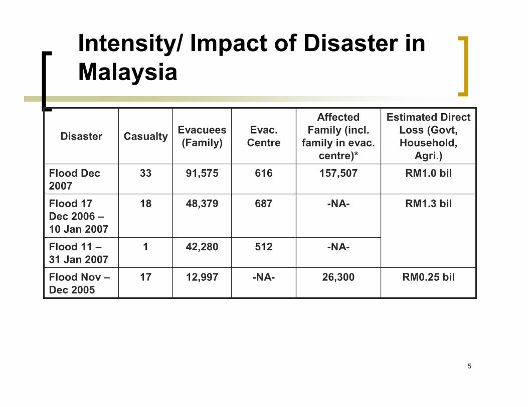
Land Use Planning Appraisal
for Risk Areas (LUPAr)
� By Town and Country Planning Dept.;
� A current research program under 9th Malaysia Plan;
� Component: flood, landslide, tsunami, forest fire, hazardous industries.
� Purpose: to provide general guidelines on the type of development allowed in hazard-prone areas and to provide mitigation measures for policy makers, decision makers, national disaster managers, local authorities.
14
Land Use Planning Appraisal
for Risk Areas (LUPAr)

15
Disaster Management
Application System
� Developed by Malaysia Centre for Remote Sensing (MACRES)
� Has been introduced to establish a central system for collecting, storing, processing, analyzing, and disseminating value-added data and information to support the relevant agencies in the mitigation and relief activities of disaster management in the country.
� Enables all government agencies to be well prepared in handling disasters as it provides important data and information about natural disasters.
� Emphasizes on the utilization of remote sensing technologies, Geographical Information System (GIS) and Global Positioning System (GPS) technologies to provide up-to-date and reliable data to support the three components of disaster management, that are, (i) early warning, (ii) detection and monitoring, and (iii) mitigation and relief for pre, during and post disaster management activities coordinated by NSC and implemented by relevant authorities.

16
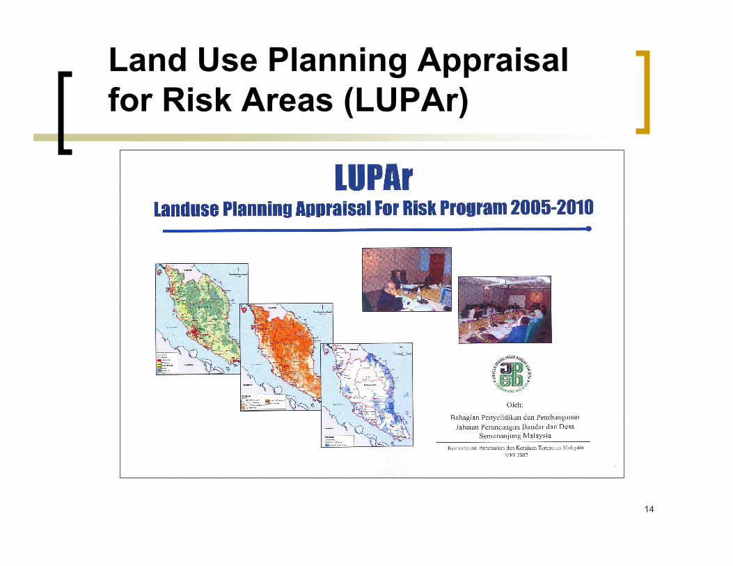
Why Disaster Management
Application System ?
� Previously, effective national planning by central planning agencies is constrained by the absence of a centralized and integrated database on natural resources, environment and related information with full geographic analytical capabilities
� Due to:� Relevant databases are not readily available as they reside in
different operational environment of various agencies;
� Data are not standardized (in terms of format, scale and level of mapping accuracies) and therefore are not readily available for GIS analyses; and
� Some in analogue form
17
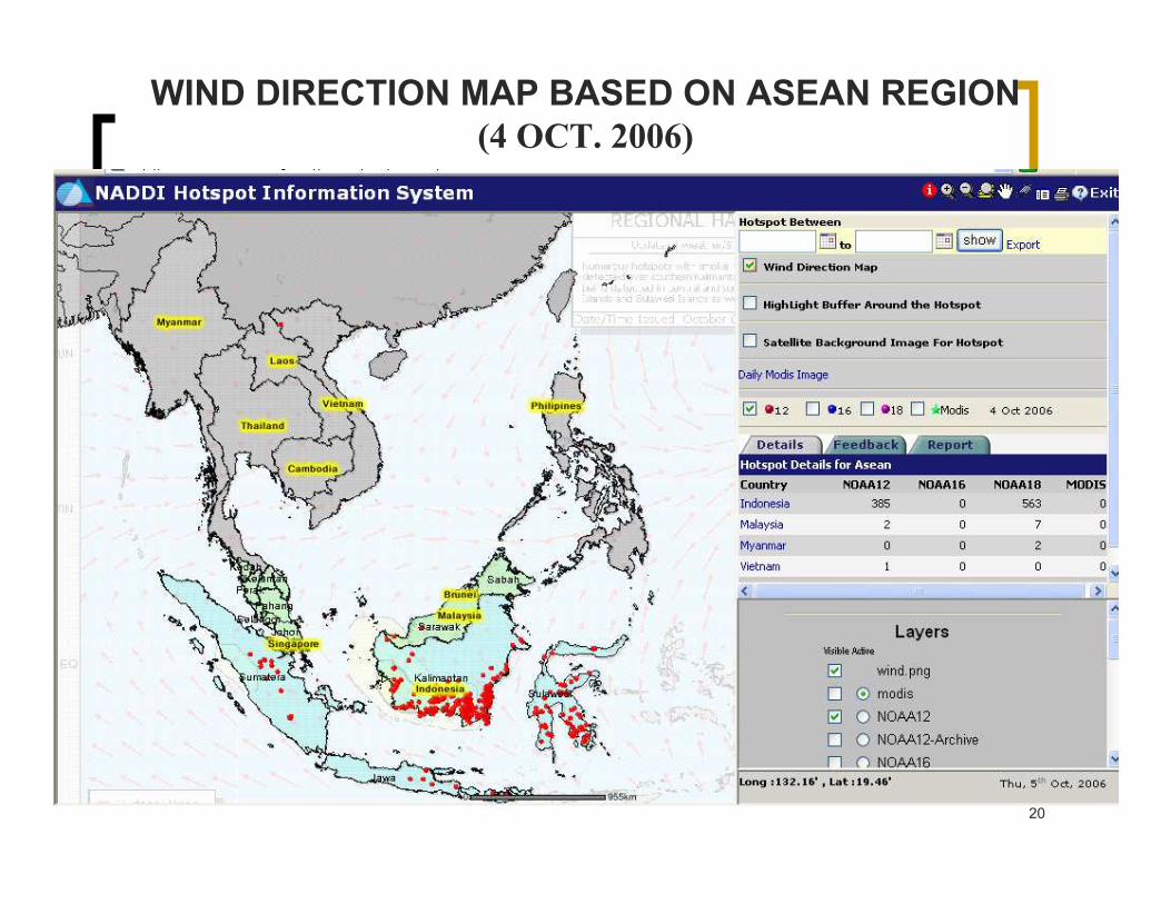
• AUTOMATED DAILY HOTSPOTS
MONITORING SYSTEM
– NOAA 12, 16 AND 18 (ASMC)
– MODIS (MGRS)
– ACTIVE FOREST FIRE MAP
– WIND DIRECTION MAP (ASMC)
Pilot Scale Hazard Mapping

18
PILOT AREA :
� RAJA MUDA MUSA RESERVE FOREST
FOREST FIRE DISASTER MODEL

19
20
WIND DIRECTION MAP BASED ON ASEAN REGION
(4 OCT. 2006)

21NOAA 12
NOAA 18

22
NOAA 16
MODIS

23
PILOT AREA :
� PENANG ISLAND
LANDSLIDE DISASTER MODEL

24

25

26

27
PILOT AREA :
� TANJUNG PIAI
OIL SPILL DISASTER MODEL

28

29
PILOT AREA :
� KELANTAN RIVER
BASIN
FLOOD DISASTER MODEL

30

31
PILOT AREA :
� GEBENG INDUSTRIAL PARK
HOT INSTALLATIONS DISASTER MODEL

32

33

34
33--D TSUNAMI INUNDATION MAP (PENANG)D TSUNAMI INUNDATION MAP (PENANG)
Kuala Pulau Betung
Balik Pulau
Batu Feringgi
1
2
3
1
2
3

35
PREPAREDNESS

36
Directive No. 20
National Security Council
� Directive No. 20 National Security Council: The Policy and Mechanism on National Disaster and Relief Management established on 11th May 1997;
� Takes along the power of Law because it was signed by the Prime Minister as Directive of Operation who derive the power of His Majesty the King in the Emergency (Essential Powers) Ordinance 1970

37
Defining Disaster
� Incident that occurs in a sudden manner, complex in nature, resulting in the loss of lives, damages to property or the environment as well as affecting the daily activities of local community.
� Such incident requires the handling of resources, equipment, frequency and extensive manpower from various agencies as well as effective coordination and the possibility of demanding complex actions over a long period of time.
38
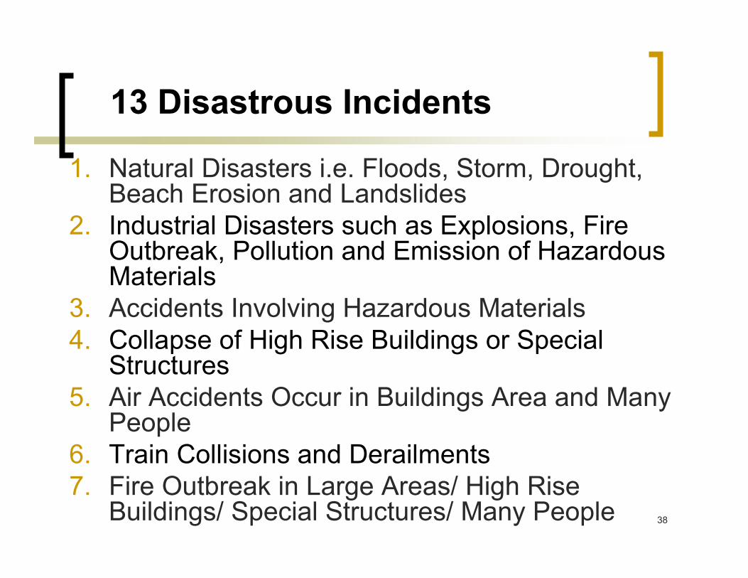
13 Disastrous Incidents
1. Natural Disasters i.e. Floods, Storm, Drought, Beach Erosion and Landslides
2. Industrial Disasters such as Explosions, Fire Outbreak, Pollution and Emission of Hazardous Materials
3. Accidents Involving Hazardous Materials
4. Collapse of High Rise Buildings or Special Structures
5. Air Accidents Occur in Buildings Area and Many People
6. Train Collisions and Derailments
7. Fire Outbreak in Large Areas/ High Rise Buildings/ Special Structures/ Many People

39
13 Disastrous Incidents
8. The Burst of a Hydro Dam or Reservoir
9. Nuclear and Radiology Mishaps Which May Probably Spread and Cause the Loss of Lives, Damage to Properties and Pollute the Environment
10.Emission of Poisonous Gas in Public Places
11.Haze Which Cause an Emergency Situation to the Environment and Jeopardizes Public Order, Govt. Administration and Country’s Economic Activities
12.Air Disasters
13.Sea Disasters

40
Level of The Disaster Management and
Relief Committee (STRATEGIC LEVEL)
� Policy and Strategic Planning
� Level 1: The District Disaster Management and Relief Committee
� Level 2: The State Disaster Management and Relief Committee
� Level 3: The National Disaster Management and Relief Committee
Federal
Deputy Prime Minister
State
State Secretary
District
District Officer
Secretariat:
NSC

41
Operational Approach
� Bottom Up Approach
� If the District has shortage of Manpower,
Fund and Asset, the state level or federal
level will assist and coordinate

42
• Search and
Rescue
• Health and
Medical
Services
• Media
• Support
• Security
Control
• Welfare
• Warnings and
Alerts
Federal Disaster
Operation Control Centre
(Deputy Prime Minister)
State Disaster
Operation Control Centre
(State Secretary)
District Disaster
Operation Control Centre
(District Officer)
On-scene
Post
On-scene
Post
National
Security Council
State
NSC
District
NSC
Federal
Disaster Management
and Relief Committee
State
Disaster Management
and Relief Committee
District
Disaster Management
and Relief Committee
Organizational Structures
Officer in
Charge
Of Police
District (OCPD)
Officer in
Charge
Of Police
District (OCPD)
Officer in
Charge
Of Police
District (OCPD)
On-scene
Post

43
Capacity Building
� Several agencies designated to be lead agency in specific disaster
� Pandemic/ Endemic for human being (Ministry of Health)
� Pandemic/ Endemic for bird/animal (Ministry of Agriculture)
� Sea Disaster (Marine Department)
� Air Disaster (Dept. of Civil Aviation)
� Haze/ Open Burning (Dept. of Environment)
� Nuclear and Radiology (Atomic Energy Licensing Board)
� Chemical (Chemistry Dept.)
� Search and Rescue Team (Multi Function) – Fire and Rescue Dept., Royal Malaysian Police, Malaysian Armed Forces, Special Malaysian Disaster Assistant and Rescue Team (SMART), Emergency Medical Team, Atomic Energy Licensing Board and Civil Defense Dept.

44
Early Warning System
� Malaysian Meteorological Department (MMD)
� Tsunami Early Warning System
� Weather Forecasting
� Disaster Alert System (D.A.S)
� Malaysian Department of Irrigation and Drainage (DID)
� Telemetry System - Flood Forecasting Models and Infobanjir
� Malaysian Centre for Remote Sensing (MACRES)
� Disaster Management Applications System
� Department of Environment (DOE)
� Air Pollutant Index (API) - Haze

45
Malaysian Tsunami Early
Warning System
� After the Asian Tsunami in Dec 2004
� Developed by Malaysian Meteorological Dept.
� Three technologically advanced deep water buoys to be deployed at locations around Malaysia.
� The first buoy was installed near Pulau Rondo, Sumatra on 30 December 2005
� The second buoy installed at Peninjau Island on the South China Sea in early March 2006
� The third buoy will be located in the Sulu/ Sulawasi Sea by end of 2008
� Dissemination System: Short Messaging System (SMS), mass media, telephone, fax and website

46
Flood Forecasting and Warning
System
� Developed by Malaysian Drainage and Irrigation Dept.
� Currently two flood forecasting models have been applied i.e the Linear Transfer Function Model (LTFM) at Pahang River and the Tank Model at Kelantan River
� The agencies involve in flood relief have use the information to decide when they should mobilize their staffs and equipments to the areas that are potentially hit
� Dissemination System: Warning siren, Short Messaging System (SMS), telephone, fax and website http://infobanjir.water.gov.my

47
TELEMETRY SYSTEM
- FOR FLOOD FORECASTING MODELS AND INFOBANJIR
HYDROLOGICAL SENSORS
LAND EARTH STATION
RADIO REPEATER STATION
SATELLITE
NETWORK CONTROL CENTER
RTU
RADIO LINK
WORK STATIONS
MASTER TERMINAL
CONNECTION TO
WORK STATION BY
LAN,WAN,INTERNET
FRONT END PROCESSOR
RAINFALL
WATER LEVEL
SIRENS, WEB CAMERA
SMS TO MOBILE PHONE
LAND LINE

48
3-Tier Communication Approach
GOVERNMENT
1. GIRN
2. FLAS
TV
PUBLIC
3. “999”

2nd Asian Ministerial Conference on Disaster
Risk Reduction
49
Government Integrated Radio
Network (GIRN)
� A Government Integrated Radio Network (GIRN) project was recently introduced to provide secure digital trunk radio system between the various government agencies in Malaysia as a study shows that there are currently more than 12 radio networks used by the various agencies.
� The current radio networks have several limitations:
� Limited radio network coverage over the country;
� Ineffective radio network coverage resulting in limitation for facilities sharing;
� Networks are using various type of technology and do not adhere to any standard;
� Lacks of capability due to outdated technology; and
� Frequencies used are not as recommended in “Standard Radio System Plan” by the Malaysia Communication and Multimedia Commission (MCMC).
� The introduction of the GIRN project preserves the autonomy and freedom of the various agencies while providing a unified network of shared infrastructures.

2nd Asian Ministerial Conference on Disaster
Risk Reduction
50
Government Integrated Radio
Network (GIRN)
� The benefits of the GIRN approach are:
� Shared infrastructure creates “economies of scale”, and the effort to cover the whole country can be reached in a reasonable cost;
� Digital Technology enables the sophisticated and integrated audio and data services;
� The technology used is standardized and the level of “interoperability” increased without interrupting the autonomy;
� The level of security increased in radio and data communication;
� Frequencies used as recommended in Standard Radio System Plan by Malaysian Communications and Multimedia Commission (MCMC) and communication services in the government can be restructured.
� GIRN will certify that every agency’s network would be physically and virtually separated. Every agency would manage the equipments and assets on its own. It can utilise and manage the network using its own and unique command and control policy. The network is virtuallyseparated by using different System Number for each agency.

51
Government Integrated Radio
Network (GIRN)

52
Fixed Line Alert System (FLAS)
� The advantages:
� short and precise message dissemination
� quick
� 24 hours operations
� pre-recorded message or real-time message
� specific area for dissemination.
� simultaneously broadcast thousands calls at any one time
� able to generate statistic or report for successful, unanswered and failed calls

53
Fixed Line Alert System (FLAS)

54
“999” – Dedicated Emergency
Line
� Customer Assistance Service (CAS) by Telekom Malaysia Berhad (TM)
� Response Time Within 10 seconds - > 96.4%

55
Flood Mitigation Structure i.e. The Stormwater
Management and Road Tunnel (SMART)
� Developed by Malaysian Drainage and
Irrigation Department
� The Stormwater Management and Road
Tunnel also known as SMART Project is
being developed to alleviate flash flood
problems in the city. The 9.7 kilometers
and 11.83 meters’ in diameter tunnel
integrates both stormwater management
and motorway in the same tunnel.

56
National Disaster Relief Trust
Fund (NDRTF)
� Annual allocation from the Government
� Change from fund to trust fund in 2005
where public and private also can
contribute
� Base on the experience on tsunami where
RM78.9 mil was contributed by public and
private during the disaster

57
Standard Operating Procedures/
Emergency Response Plan (ERP)
� Standard Operating Procedures (S.O.P.) on preparation, prevention, response, recovery and rehabilitation
� Three major S.O.P.
� S.O.P. for flood (Chapter 1);
� S.O.P. for industrial disasters (Chapter 2);
� S.O.P. for forest fire/open burning and haze (Chapter 3); and
� SOP for Oil, Gas and Petrochemical Disasters.� National Contingency Plan for Oil Spill Combat
� S.O.P. on Pandemic/ Endemic Preparedness Plans
� Earthquake, Tsunami and Drought Disasters – in progress
� Emergency Response Plan (ERP) for each private area

58
Development Program by Town and
Country Planning Dept.
� Applying the Building Code for Seismic Risk on High Rise Buildings for local planning at Kota Kuala Muda, Kedah
� Applying Other Relevant Code and Guideline With Regard to Development
� Urban Stormwater Management Manual (MASMA) Guideline
� Dept. of Environment – permissible density and cutting slope for development
� Guideline on Development within gas pipeline
� Permissible Height for Building Around Airport

59
Bilateral, Regional and International
Cooperation
� Bilateral
� MoU with Thailand
� MoU with Indonesia (Disaster Cooperation and
Assistance)
� MoU with France (Disaster Cooperation and
Assistance)
� Singapore Civil Defense Force (SCDF) (Bilateral
networking/ Cooperation and Assistance)

60
Bilateral, Regional and International
Cooperation
� Regional Membership
� ASEAN
� ASEAN Committee on Disaster Management (ACDM)
� ASEAN Regional Forum (ARF)
� Asian Disaster Reduction Centre (ADRC)
� Asian Disaster Preparedness Centre (ADPC)
� Intergovernmental Coordination Group – Indian Ocean
Tsunami Warning System (ICG-IOTWS)
� APEC Task Force on Emergency Preparedness (TFEP)
� 3rd Asian Ministerial Conference on Disaster Risk
Reduction – Dec 2008 in Kuala Lumpur
� Global Platform on Disaster Risk Reduction – 2009

61
Bilateral, Regional and International
Cooperation
� International Membership
� United Nations Office for the Coordination of Humanitarian Affairs (UN-OCHA)
� United Nations Disaster Assessment and Coordination (UNDAC)
� United Nations – International Search and Rescue Advisory Groups (UN – INSARAG)
� United Nations – International strategy for Disaster Reduction (UN-ISDR)
� United Nations Economic and Social Commission For Asia and The Pacific (UNESCAP)
� Typhoon Committee
� World Meteorological Organization (WMO)
62
RESPONSE AND RELIEF
63
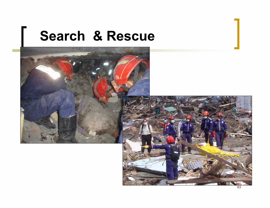
Search & Rescue
64
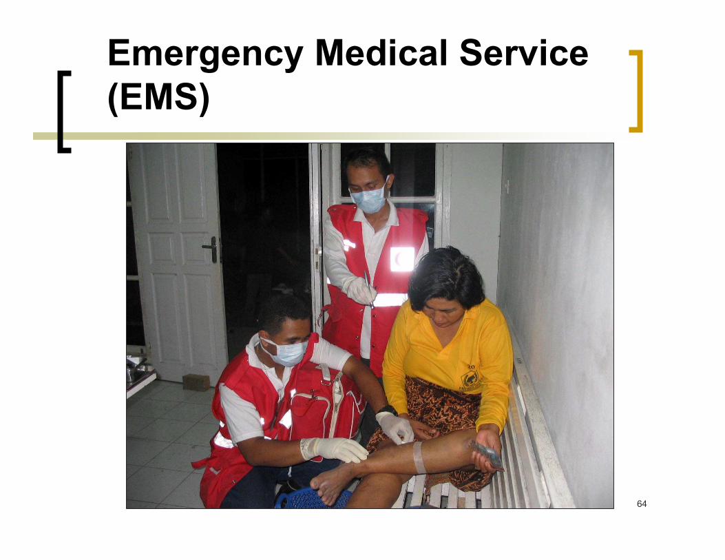
Emergency Medical Service
(EMS)
65
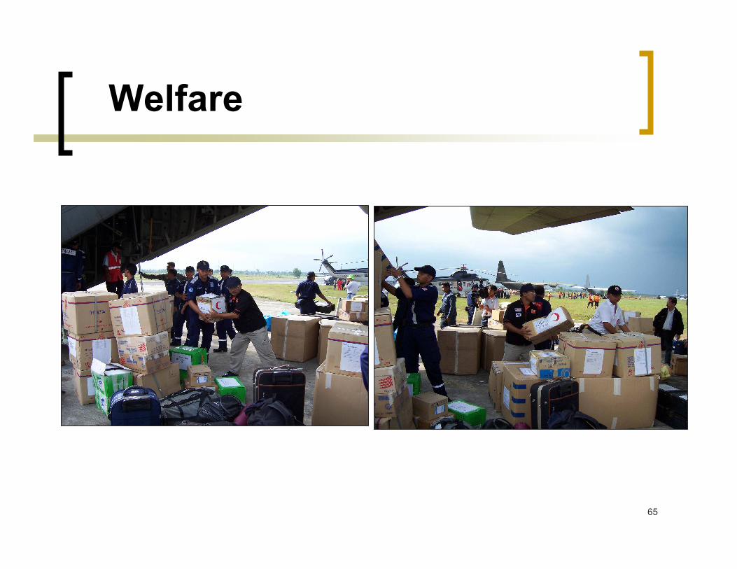
Welfare

66
Evacuation

67
Role of Non Government
Organization (NGOs)
� To provide assistance in disaster mitigation, response,
recovery, rehabilitation and construction;
� Malaysian Red Crescent Society (MRCS) – medical
assistance and rehabilitation
� MERCY – medical assistance and rehabilitation
� Haluan Malaysia – rehabilitation and reconstruction
� Global Peace Malaysia – medical assistance and
rehabilitation
� Global Sikh Malaysia – health assistance and rehabilitation
� AMAN Malaysia – rehabilitation and reconstruction
� St. John Ambulance – medical assistance
� Force of Nature – fund

68
REHABILITATION

69
4. Rehabilitation
� To address the immediate needs of the affected communities � National Disaster Relief Fund
� To reconstruct essential utilities, services and houses
� Medical and health care for victims
� To address the issue of economic well being of affected communities
� Reconstruction and Resettlement of Houses destroyed during tsunami and flood

70
THE CONSTRUCTION OF PERMANENT HOUSES THE CONSTRUCTION OF PERMANENT HOUSES IN KOTA KUALA MUDA, KEDAHIN KOTA KUALA MUDA, KEDAH
Permanent Houses

71
Repair works at the affected areaRepair works at the affected area(Location: (Location: SeberangSeberang PeraiPerai Utara & Daerah Barat Utara & Daerah Barat DayaDaya, Penang), Penang)
BEFORE AFTER
Repair WorksRepair Works

72
Transitional HousesTransitional Houses Transitional Houses
(Location: Kota Kuala (Location: Kota Kuala MudaMuda, Kedah & Daerah , Kedah & Daerah TimurTimur LautLaut, Penang), Penang)

73
The Way Forward
� To extend the development of the
specific disaster hazard mapping at a
larger scale
� To maximise the use of remote sensing
applications as important instruments
for societal well being of the nation

74
Conclusion
� Remote sensing and related
technologies are useful tools for Land
Use Planning and Disaster Management
� Collaboration between technology
provider agencies with disaster
management must be strengthen

75
THANK YOU