Embed Size (px)
Citation preview
Discover PA 2015
NEW FEATURES IN 2015 Discover PA provides a tool that is suited to interactive interpretation and consistent presentation of
geophysical data imported from other standard software applications as well as that created within the
software using one of the numerous processing utilities. The dynamics, interaction and ease-of-use make this
an essential tool to ensure the delivery of the best outcomes for your project.
The 2015 release introduces improved interoperability between it and MapInfo-Discover and Discover 3D. As a
result of this we are excited to be able to bridge the gap between geology and geophysics and combine them
together even more to improve discovery. For example, it is now possible to load packaged session files
generated in Discover 3D into Discover PA or packaged session files generated in Discover PA into the newly
combined Discover Viewer package (replacing the 3D Viewer and PA Viewer packages), which has been
released in conjunction with Discover PA 2015. The release of Discover 2015 later this year will allow packaged
sessions created in Discover PA to be loaded into Discover 3D.
These release notes include descriptions of the changes to and new features in Release 2015 of Discover PA:
New “Discover Viewer” installation
Universal management of Discover PA and Discover 3D session files (.EGS)
“Save View As” option for individual or framed profiles to export displays to MapInfo .TAB files
Improvements to Flight Path Simulator
Feature Manager analysis of surfaces
Updates to IGRF calculations to support 2015 magnetic field corrections
Export Conductivity-Depth sections to Autodesk 3D Studio (.3ds) format
Fully automated licensing system
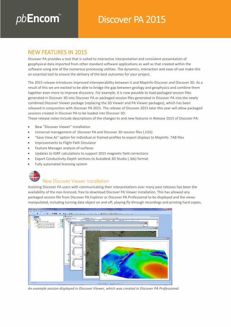
New Discover Viewer Installation Assisting Discover PA users with communicating their interpretations over many past releases has been the
availability of the non-licenced, free to download Discover PA Viewer installation. This has allowed any
packaged session file from Discover PA Explorer or Discover PA Professional to be displayed and the views
manipulated, including turning data object on and off, playing fly-through recordings and printing hard copies.
An example session displayed in Discover Viewer, which was created in Discover PA Professional.

We are excited to introduce a replacement Viewer package for this installation, called Discover Viewer, which
contains the same functionality that the original viewer package provided but now in addition supports
packaged session files created in Discover 3D as well as Discover PA.
New Interoperability options with MapInfo-Discover and Discover 3D
Universal Management of Sessions: In addition to the sharing of session files in the Discover Viewer 2015 installation Pitney Bowes has
implemented universal management of session files (.EGS) in both Discover 3D and Discover PA which in past
releases of both software programs restricted the sharing of session files across interfaces.
With this release of Discover PA 2015 it is possible to load a session file created in Discover 3D and use the
extensive suite of different data objects and data processing utilities to further advance your geological
interpretation. With the release of Discover 2015 (and Discover 3D) later this year it will then be possible to
load a session file created in Discover PA (consisting of a 3D display) into the Discover 3D program to complete
the data collaboration.
Export Profile/Map displays to a MapInfo .TAB file The ability to save any display window in Discover PA as a high resolution image (.PNG, JPG, TIFF, BMP) has
been available in the software for many versions. Now available in the 2015 release is the ability to save a
single view (single profile, map or 3D view) or an entire display window (template) to a high resolution display
which has a MapInfo .TAB file associated with it. The saved image will retain the same Y- and X- axis aspect
ratio scaling as were set in Discover PA.
This improves the collaboration of interpretation concepts realised in Discover PA and MapInfo-Discover and
provides a means for displaying advanced curve profiles of geophysical data in a GIS environment.

A .PNG image of two consecutive conductivity-depth sections displayed in MapInfo Professional.
To access this image saving option, simply view the pop-up menu for the Profile 1 or Map 1 branch in the
workspace tree, or else select the File>Save View As… menu option. To save the view with an associated
MapInfo .TAB file the Create TAB file option must be selected. To display the output immediately in MapInfo
Professional the Open in MapInfo option can also be selected.
Note that the latter option will only work if MapInfo Professional is already running.
The Save View option can be selected from the Profile 1 branch of the workspace tree or the File menu.
Improvements to the Flight Path Simulator The Flight Path Simulator has had some improvements implemented making it more intuitive to use for
designing or simulating airborne surveys.

Point of Origin: The previous version used the centroid of the input DTM as the point of origin but this has been improved so
that the end-user can nominate a target coordinate (X, Y) as the point of origin. This improves the quality of
coverage for known areas or points of interest.
Flight Path Simulator dialog showing the X/Y coordinates for a specific point of origin.
Bounding Polygon .FDB Support It is possible in the utility to load a vector file containing a polygonal region which can be assigned as the
bounds for the survey design. Previous versions only allowed vector file formats of .TAB, .MIF or .SHP. In this
release the input support has been expanded to allow the loading of a feature database polygonal object to be
used as the bounding polygon. If a feature database is used for the input which contains multiple polygons
then only the first polygon will be used.
The labels for the bounds section in this utility have also been changed to “X” and “Y” to be consistent with the
other settings in the interface.
Flight Path Simulator showing the Open Survey Polygon input dialog.

Feature Manager Improvements – Check for Holes A new tool has been added to the Feature Editing toolbar called the Topology Report, which allows the end-
user to run a process to check for consistencies across selected solid features with regards to the number of
Vertices, Edges, Faces and Cells in the selected object.
The button is only selectable if one or more solid feature objects are selected in a 3D display.
If any unclosed surfaces are identified then the user can proceed to edit the feature object using the advanced
feature editing tools. This improves the pre-work required when exporting such a feature object as a
ModelVision .TKM or AutoCAD .DXF file for further use in the magnetics and gravity modelling software,
ModelVision, which only supports closed 3D bodies.
The Topology report dialog can identify any unusual external edges in a 3D solid object.
IGRF Improvements An IGRF coefficient file in Discover PA is used for computing the magnetic field for a dataset prior to
calculating certain processes, such as “reduction to the pole” filtering in grids and line data.
A new IGRF model has been published for 2015 (http://www.ngdc.noaa.gov/IAGA/vmod/igrf.html) and so
this model is now accounted for when using the Grid Filter and Line Filtering utilities.

Pitney Bowes Software, Inc. Is a wholly-owned subsidiary of Pitney Bowes Inc. Pitney Bowes, the Corporate logo, pbEncom, Discover PA and MapInfo Professional are [registered] trademarks of Pitney Bowes Inc. or a subsidiary. All other trademarks are the property of their respective owners. © 2015 Pitney Bowes Software, Inc. All rights reserved.
Updated Fully Automated Licensing System A new fully automated licensing system has been implemented in Discover PA 2015. The advantages of this for
the end-user are:
Significantly faster activation times (less than 20 seconds).
Removal of the need for emails and manual intervention by the user in the activation process
The Licence Manager program requesting licence activation for Discover PA.
Export Conductivity-Depth Section to Autodesk 3D Studio file format
Added ability to convert CDI section (.EGB) to 3D Studio file (.3ds) To improve interoperability with other software applications Discover PA 2015 now has the ability to export a
Conductivity-Depth section to an Autodesk 3D Studio .3DS file. This is accomplished using the same method
available to generate a located image (.EGB file). To create a .3DS file select the Save as Georeferenced
Image… option from the pop-up menu of the Profile 1 branch in the workspace tree.
Creating an Autodesk 3D Studio file for a section profile in Discover PA.