Embed Size (px)
Citation preview
American Geographical Society
Discoveries in Central Asia and TibetSource: Bulletin of the American Geographical Society, Vol. 34, No. 4 (1902), pp. 313-315Published by: American Geographical SocietyStable URL: http://www.jstor.org/stable/197673 .
Accessed: 08/05/2014 18:12
Your use of the JSTOR archive indicates your acceptance of the Terms & Conditions of Use, available at .http://www.jstor.org/page/info/about/policies/terms.jsp
.JSTOR is a not-for-profit service that helps scholars, researchers, and students discover, use, and build upon a wide range ofcontent in a trusted digital archive. We use information technology and tools to increase productivity and facilitate new formsof scholarship. For more information about JSTOR, please contact [email protected].
.
American Geographical Society is collaborating with JSTOR to digitize, preserve and extend access to Bulletinof the American Geographical Society.
http://www.jstor.org
This content downloaded from 169.229.32.137 on Thu, 8 May 2014 18:12:11 PMAll use subject to JSTOR Terms and Conditions
DISCOVERIES IN CENTRAL ASIA AND TIBET.
The expedition to Central Asia and Tibet, sent out in the spring of I899 by the Russian Geographical Society, under the command of Captain P. K. Kozloff, has accomplished very important results. The geographical discoveries relate (i) to the Chinese or Mongo- lian Altai, the great mountain chain extending across western Mon-
golia from Siberia far towards China; (2) to the Gobi, between the eastern part of the Southern Altai and the northern frontier of
China; and (3) to the eastern part of Tibet, known as the Kam. Distinctive features of the expedition were: the sending out of
separate excursions from the main body of the caravan, thus widen-
ing the domain of exploration; the maintenance for fifteen months of a meteorological station in eastern Tsaidam (northeastern Tibet), the first time that such work has been done in Central Asia; and the
study of the depths, flora, and fauna of Central Asian lakes with the aid of a canvas boat.
The Altai were explored both on their northern and southern sides. It was found that the part of the mountains lying to the west of Kobdo (about 92? E. Long.) are high, and contain masses of
glaciers and snow-clad peaks. These mountains have abundant
precipitation and extensive forests. To the east of Kobdo, how-
ever, the mountains rarely reach the snow-line, and, owing to the
dry southern winds from the Sungarian desert and the Gobi, have few forests and Alpine meadows, though the Mongols here raise
many sheep, cattle, horses, and some camels. The Gobi desert was crossed in three directions by various expe-
ditions led by Kozloff and his companions Ladyghin and Kaznakoff.
They found the Gobi very different from the descriptions usually given of it. The Gobi has often been represented as a flat land covered with sand and having no mountain features except in its western part. The northern part of the Gobi, however, for about 200 miles southward, is crossed from east to west and from northwest to southeast by mountains and ranges of hills, among whose valleys Mongols, with their herds of camels, are occasionally found. This part of the Gobi is easy of access, and is crossed by many routes
provided with wells containing sweet or slightly brackish water. The central part of the Gobi is hilly in the northern portions and
sandy in the south. It was crossed successfully by Kaznakoff, with the assistance of the Mongols. The southern part is a barren
313
This content downloaded from 169.229.32.137 on Thu, 8 May 2014 18:12:11 PMAll use subject to JSTOR Terms and Conditions
Discoveries in Central Asia and Tibet.
desert, covered with sand. Here all the riding horses died for want of grass.
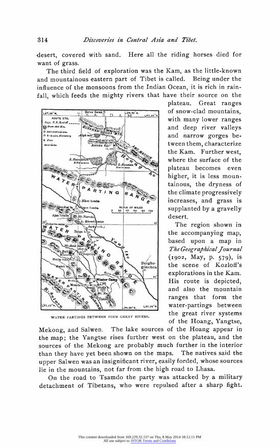
The third field of exploration was the Kam, as the little-known
and mountainous eastern part of Tibet is called. Being under the influence of the monsoons from the Indian Ocean, it is rich in rain-
fall, which feeds the mighty rivers that have their source on the
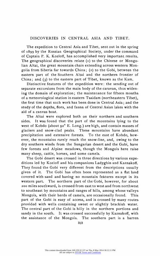
plateau. Great ranges LAT.36?N. BaruZaakO LN.98?. O of snow-clad mountains,
ROUCapt. P.K.ETo:.. A: with many lower ranges
Snow..cadt,t. az) ;, f/,.;.. and deep river valleys ,n .^o., on^,..ry A. y~k'jT/ and narrow gorges be-
..o.a.t :. Amnen, Kra, tween them, characterize
:_^i to tthe Kam. Further west, ,,:W,LE 225E22pe where the surface of the
n'.- ora-o 3 plateau becomes even
'; ~ (2," :s higher, it is less moun-
*
e'
I"V N ..:G N O ^ the climate progressively , ikar homba increases, and grass is
, C m -au . L %i2
homb 0 40 cOF
MILES supplanted by a gravelly
Ajako s..bia . desert. 32? X!,5)^ \. RSfombdRtmtso - * . ,,ao O ,in-o:"~" 32
RAoamb mtll.) 32 The region shown in
L Ta
i 4bhase the accompanying map, ;m^i~i ~~ ^i?\ ^ ''-? fbased upon a map in
M.aaik l^l^ 7 a , r Thze GeeographicalJournal
aH" trtu t t " (1902, May, p. 579), is
eblaL; IS oDe ghe- the scene of Kozloff's
M~'^^ lZf^\S^^^q0 0 explorations in the Kam. :r" .Wnte Ca.? n His route is depicted,
o ra nesgt and also the mountain
L ""' .;
'. . .ranges that form the
-LAT.29 foN. 0.95?E. *LT.9 ? water-partings between the great river systems
WATER PARTINGS BETWEEN FOUR GREAT RIVERS.
of the Hoang, Yangtse, Mekong, and Salwen. The lake sources of the Hoang appear in the map; the Yangtse rises further west on the plateau, and the sources of the Mekong are probably much further in the interior
than they have yet been shown on the maps. The natives said the
upper Salwen was an insignificant river, easily forded, whose sources lie in the mountains, not far from the high road to Lhasa.
On the road to Tsamdo the party was attacked by a military detachment of Tibetans, who were repulsed after a sharp fight.
314
This content downloaded from 169.229.32.137 on Thu, 8 May 2014 18:12:11 PMAll use subject to JSTOR Terms and Conditions
Discoveries in Central Asia and Tibet.
Representatives of the Lhasa authorities, however, implored the Russians not to enter the monastery of Tsamdo, which is one of the great sanctuaries of Tibet. The explorers accordingly turned east and wintered in the warm, wooded valley of the Ra-Chu, a tributary of the Mekong. Here meteorological and astronomical observa- tions were made, numerous specimens of the flora and fauna were collected and many materials relating to the history and ethno-
graphy of the Tibetans. The country was explored as far eastward as the monastery Derghe-gonchen.
The population of this part of Tibet is partly settled and partly nomad. The settled inhabitants have their houses and farms in the valleys and gorges, where they grow cereals up to an altitude of
I2,ooo feet. The nomads pitch their black tents in the region of the Alpine meadows, whose upper limits are some 3,500 feet higher than the limits of the agricultural zone. The settled population, living better than the nomads, occupy houses of small logs or wickerwork covered with clay, usually two to three stories in
height-the lower floor for the cattle and the others for the inhabi- tants, and also for grain and hay storage. The dress of both sexes is sheepskin, though in summer the richer folk wear a sort of woollen dressing gown. They practice polyandry, several brothers often
taking one wife. The work of the expedition included about 8,ooo miles of survey,
forty determinations of geographical positions, daily meteorological observations, many photographs, and very rich natural history col- lections, which are now being studied by specialists in St. Peters- burg. The fullest reports on the work of this fruitful expedition, excepting those in the Izvestiya of the Imperial Russian Geographi- cal Society, have appeared in Petermanns Mitteilungen (I901, pp. 90, i6o, 182, 205, 237, 260; 1902, pp. 137, 163, I84), and in The Geo-
graphical Journal (May, 1902).
315
This content downloaded from 169.229.32.137 on Thu, 8 May 2014 18:12:11 PMAll use subject to JSTOR Terms and Conditions