Embed Size (px)
Citation preview

©2016 Society of Economic Geologists, Inc.Economic Geology, v. 111, pp. 447–466
Dismembered Porphyry Systems near Wickenburg, Arizona: District-Scale Reconstruction with an Arc-Scale Context
Phillip A. Nickerson†,* and Eric SeedorffLowell Institute for Mineral Resources, Department of Geosciences, University of Arizona,
1040 East Fourth Street, Tucson, Arizona 85721-0077
AbstractThis study combines results from reconnaissance-scale mapping of hydrothermal alteration, rock types, and
structures to provide a district-scale cross section and associated palinspastic reconstruction of an area with two previously undescribed Laramide (~70 Ma) porphyry systems at Sheep Mountain and Copper Basin (Crown King). Extension at the district scale is placed in an arc-scale context using an original compilation of strike and dip measurements on Tertiary rocks to reconstruct the Laramide porphyry belt prior to extension.
The study area contains five sequential, partially superimposed sets of normal faults that are nearly planar where exposed. Dips of all normal faults initiated at 60° to 70° and rotated during slip to angles as gentle as 20°. A palinspastic reconstruction reveals that two, spatially distinct hydrothermal systems overlie different cupolas of a Late Cretaceous pluton. Hydrothermal alteration is zoned from greisen to potassic to transitional greisen-potassic assemblages from deep to shallow structural levels. The reconstruction is used to identify two covered exploration targets. The prospects may be porphyry molybdenum systems of the quartz monzonitic-granitic porphyry Mo-Cu subclass, joining others in an arc that is best known for porphyry copper deposits.
The Laramide porphyry belt prior to extension displays a variably well-defined axis, ~100 km wide, with gaps and clusters of deposits along its 700-km strike length. The majority of deposits lie along the axis, but others lie in fore- or rear-arc positions. The interpreted preextensional geometry of the Laramide porphyry belt resem-bles other porphyry belts and the distribution of active volcanoes at convergent margins.
IntroductionIn southwestern North America, the Cenozoic Basin and Range extensional province is superimposed upon the Laramide (80–50 Ma) magmatic arc (Wilkins and Heidrick, 1995; Barton, 1996). The Laramide magmatic arc contains many well-studied porphyry systems (e.g., Titley and Hicks, 1966; Titley, 1982a; Pierce and Bolm, 1995; Fig. 1). However, few previous investigations consider the effect that postmin-eralization normal faulting has had on spatial relationships at the deposit or district scale (e.g., Lowell, 1968; Wilkins and Heidrick, 1995; Wodzicki, 1995; Stavast et al., 2008), and especially at the scale of the magmatic arc (Richard, 1994; Staude and Barton, 2001).
At the deposit and district scale, the superposition of normal faults and porphyry systems creates challenges and benefits for the study of both extensional and hydrothermal processes. Challenges can arise where hydrothermal altera-tion obscures subtle distinctions in certain stratigraphic units that might serve as important structural markers, or where orebodies are dismembered by normal faults. Benefits of this superposition arise when products of one of the geologic processes can be used to help constrain aspects of the other process. For example, predictable patterns in hydrothermal alteration zoning can be used as geologic markers that may better constrain structural reconstructions (e.g., Nicker-son et al., 2010), and, in turn, aid in better discriminating between different styles of extension. Conversely, ore-form-ing processes can be better constrained where deep levels
of ore-forming systems are exhumed and can be examined at the surface (Proffett, 1979; Carten, 1986; Dilles and Ein-audi, 1992; Seedorff et al., 2008).
Regional-scale reconstructions commonly subdivide regions into extensional domains and then restore extension in each of the extended domains (e.g., McQuarrie and Wernicke, 2005). At the arc scale, such reconstructions can aid in understand-ing tectonic processes or, as attempted here, the original dis-tribution of porphyry deposits along a magmatic arc.
This study focuses on a poorly understood segment of the Laramide porphyry copper belt in the White Picacho and Sheep Mountain districts (Keith et al., 1983), near the town of Wickenburg in central Arizona (Fig. 2), and provides the first public description, notwithstanding company reports, of hydrothermal features observed in the Copper Basin (Crown King) and Sheep Mountain porphyry systems. Previous detailed mapping of rocks types and structural geology (Peter-son, 1985; Capps et al., 1986, Stimac et al., 1987; R. Powers, unpub. map) is combined with original, reconnaissance-scale mapping of hydrothermal alteration and examination of areas critical to a structural interpretation of the area, which was made possible by helicopter-assisted access. The data for rock types, structure, and alteration are used to make a structural analysis of the area, including a palinspastic reconstruction of the Oligo-Miocene extension. The reconstruction demon-strates that extension was produced by five superimposed sets of normal faults, and the district-scale reconstruction reveals two new porphyry exploration targets centered on potassic alteration. The results from the Wickenburg area are placed in an arc-scale context by using the equations of Jackson and McKenzie (1983) to generate a new reconstruction of the preextension distribution of porphyry deposits along the Laramide arc.
0361-0128/16/4384/447-20 447Submitted: December 22, 2013Accepted: September 25, 2015
† Corresponding author: e-mail, [email protected] *Present address: Bronco Creek Exploration, Inc., 1815 E. Winsett Street,
Tucson, Arizona 85719-6547.

448 NICKERSON AND SEEDORFF
Geologic Setting
Porphyry deposits in Arizona are among the largest and best studied deposits in the world (e.g., Cooke et al., 2005), and many have been productive mines for over a century (e.g., Miami, Inspiration, Ray, and Morenci; Parsons, 1933; Fig. 1). Nearly all of the known porphyry deposits in Arizona formed during Laramide time (~80–50 Ma) when NE-directed subduction of the Farallon plate beneath the North Ameri-can plate produced a NW-SE-striking magmatic arc (Titley, 1982b; Lang and Titley, 1998; Leveille and Stegen, 2012). The district-scale portion of this study examines a segment of the Laramide arc located between the Globe-Miami district and the Bagdad deposit, within which a major economic deposit has yet to be identified (Fig. 1).
Extension in western Arizona
The study area near Wickenburg is located between the highly extended Harcuvar and Harquahala metamorphic core complexes (Reynolds and Spencer, 1985) to the west and the unextended Bradshaw Mountains (Rehrig et al., 1980) to the
east (Fig. 2) in the Basin and Range extensional province. Pre-vious workers in the Vulture Mountains, ~10 km west of the study area (Fig. 2), proposed that SW-dipping, listric normal faults were responsible for the observed repetition of steeply dipping (up to ~85°) Tertiary sedimentary and volcanic rocks exposed in the Vulture Mountains, as well as for the slightly less tilted (up to ~65°) Tertiary sedimentary and volcanic rocks exposed in the study area (Rehrig et al., 1980).
Subsequent detailed geologic mapping in the study area (Capps et al., 1986; Stimac et al., 1987) at 1:24,000 scale, however, revealed that normal faults are nearly planar where exposed at the surface across multiple kilometers of paleodepth and that higher angle faults cut lower angle faults. Determining the geometry, slip, and relative timing of normal faults (i.e., the style of extension) near Wickenburg is essen-tial to reconstructing the geology of the district. Furthermore, reconstruction of extension in the Laramide porphyry belt is of particular interest to economic geologists, because it can lead to the identification of offset and covered pieces of por-phyry systems (e.g., Lowell, 1968) that might be attractive exploration targets.
●
●●
●●●●
●●●
●
●●
●
● ●
●●●●●
●●
●
●
●●●● ●●
●
●
●
●●
●
● ●
MineralPark
Bagdad
Copper Basin(Prescott)
Copper Basin(Crown King)Sheep Mountain
Globe-MiamiDistrict
Resolution
Vekol
RayChristmas
Poston Sacaton
Santa Cruz
LakeshoreAjo
Silver Bell
San Manuel-
Copper SaffordDistrict
Morenci
TyroneSanta Rita
Hillsboro
PimaDistrict Peach-Elgin
RosemontRed Mountain
Cananea
La Caridad
New
MexicoA
rizon
a
Las Vegas
Phoenix
Tucson
Cal
iforn
iaN
evad
a
Arizona
Butte
Kalamazoo
Creek
Baj
a C
alifo
rnia Sonora
Chihuahua
Opodepe Cumobabi
Gulf of California
Fig. 2
108°W111°W114°W
36°N
33°N
30°N
Porphyry Systems of theLaramide Magmatic Arc
0 100 km
Fig. 1. Index map of porphyry deposits in the Laramide porphyry copper belt. Modified from Titley (1982b). The dashed box indicates the location of Figure 2.

DISMEMBERED PORPHYRY SYSTEMS NEAR WICKENBURG, AZ 449
Rock types
The geologic map of the study area is shown in Figure 3. Pre-vious geologic maps are heavily utilized in its creation (Peter-son, 1985; Capps et al., 1986; Stimac et al., 1987; R. Powers, unpub. map), especially for distribution of rock types. New mapping and field checking influenced interpretation of the nature of many contacts, and structural interpretation and dis-tribution of alteration are entirely a result of this study.
Rocks in the study area consist of Proterozoic amphibo-lite, gneiss, schist, granite, and pegmatite, intruded by Late Cretaceous granite, and overlain by late Oligocene and Mio-cene volcanic rocks (Stimac et al., 1987; Fig. 3). Proterozoic, Paleozoic, and Mesozoic sedimentary rocks, which are locally important ore hosts in certain Laramide porphyry deposits (e.g., Resolution; Manske and Paul, 2002), were denuded in the study area, most likely by erosion during uplift in the Late Cretaceous (Flowers et al., 2008).
The metamorphic Proterozoic rocks exposed in the study area belong to the Yavapai Supergroup (DeWitt et al., 2008). In the Bradshaw Mountains (Fig. 2), the Yavapai Supergroup displays a consistent N-S-striking, moderate to steeply dip-ping foliation. Variations in the foliation are used later in this study to constrain Tertiary deformation in the metamorphic rocks. Late Cretaceous granite, dated at 68.4 ± 1.7 Ma (K-Ar biotite) 10 km west of the study area in the Vulture Mountains (Rehrig et al., 1980), crops out predominantly in the western half of the study area (Fig. 3). The granite is porphyritic to equigranular in texture, containing 30 to 40% orthoclase, 20 to 30% plagioclase, 20 to 30% quartz, 3 to 5% biotite, 1 to 2%
magnetite, and up to 5% sphene, zircon, and other accessory minerals (Stimac et al., 1987).
The crystalline Proterozoic and Cretaceous rocks are over-lain by Tertiary units, which include siliciclastic sedimentary rocks, volcanic rocks, debris flows, and conglomerates. The oldest Tertiary unit is a red to brown conglomerate containing pebble- to boulder-sized clasts of older crystalline rocks and lesser volcanic rocks. The conglomerate is similar in appear-ance to the synextensional red-bed conglomerates of the Whitetail and Cloudburst Formations in southeastern Arizona (Dickinson, 1991). The conglomerate varies in thickness from 1 m to 10s of m and consistently dips steeply at ~55° to 75° to the northeast at its base. Near Buckhorn Creek (Fig. 3), the unit contains clasts of crystalline rocks exhibiting porphyry-style alteration and Cu oxide mineralization.
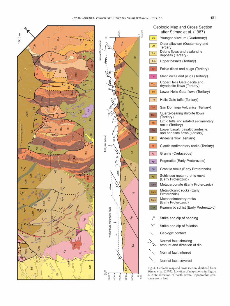
Tertiary volcanic and sedimentary rocks overlie the basal Tertiary conglomerate. The volcanic rocks are approximately 2 km thick near the Wickenburg Mountains but thicken to 4 to 5 km near Buckhorn Creek (Fig. 3). The Tertiary rocks dis-play shallowing dips from the bottom to the top of the Tertiary section, indicating that they are synextensional deposits. The geologic map and cross section in Figure 4 depict a portion of the Tertiary volcanic and sedimentary sequence mapped at 1:24,000 scale near the Wickenburg Mountains (Stimac et al., 1987).
Tertiary volcanic and sedimentary rocks have not been dated in the study area. However, volcanism in the nearby Vulture Mountains (Fig. 2) is known to have occurred between ~25 to 15 Ma (Rehrig et al., 1980). The oldest volcanic unit is a basaltic lava flow (Tlb) that in some places is interbedded with
112°30'W113°W113°30'W
34°N
33°40'N
Harcuvar MCC
Harquahala MCC
Vulture
Mountains
Bradshaw Mountains
Big HornMountains
� Copper Basin(Crown King)
●Wickenburg
Fig. 3
20km
La P
az Yavapai
Maricopa
US 60
US 60
�VultureMine
SheepMountainWickenburg
Mountains
Service Layer Credits: Sources: USGS, ESRI,TANA, AND
�Newsboy
�Hwy 60Target
BuckhornCreek Target
Geologic Map of West-Central Arizona
Quaternary undifferentiated
Tertiary volcanic and sedimentary rocks
Cretaceous and Tertiary intrusive rocks
Mesozoic and Paleozoic sedimentary rocks
Early Proterozoic schist
Early Proterozoic metamorphosed sedimentary rocks
Early Proterozoic metamorphosed volcanic rocks�
County border
Highway
Mine or resource
Exploration target
Early and Mesoproterozoic intrusive rocks
�
�
�
Fig. 2. Generalized geologic map of western Arizona, showing location of the district-scale study area of Figure 3 (gray box) relative to county boundaries and nearby mountain ranges, mines, resources, and exploration targets discussed in the text. MCC = metamorphic core complex (geology from Reynolds, 1988).

450 NICKERSON AND SEEDORFF
6052
65
69
60
66
70
2428
65
55
47
42
66
25
65
65
71
65
112°
25'W
112°
30'W
112°
35'W
112°
20'W
34°5
'N
34°N
112°
20'W
33°5
5'N
5km
�
Geo
logi
c M
ap o
f Wic
kenb
urg
Mou
ntai
ns to
Bra
dsha
w M
ount
ains
Terti
ary
Gra
vels
Upp
er v
olca
nic
and
sedi
men
tary
uni
ts
Low
er v
olca
nic
and
sedi
men
tary
uni
ts
Cre
tace
ous
Gra
nite
Pro
tero
zoic
Yava
pai S
uper
grou
pG
rani
te &
gne
iss
Met
avol
cani
c &
met
ased
imen
tary
Nor
mal
faul
ts
Buc
khor
nC
reek
Wic
kenb
urg
Mou
ntai
nsSh
eep
Mou
ntai
nW
est
She
epM
ount
ain
Eas
t
A'
A
24S
trike
and
dip
of
bed
ding
Brad
shaw
Mou
ntai
nsTg
Tg
Tg
Tvu
Tvu
Tvu
Tvu
Tvl
Tvl
Tvl
Tvl
Tvl
Tvl
Tvl
Tvl
Tvl
Kg
KgKg
KgKg
Kg
Xi
Xi
Xi Xi
Xi
Xm
vs
Xm
vs
Xm
vs
Xm
vs
Xmvs
Xm
vs
Xmvs
Xm
vs
Xm
vs
Fig.
4
Buckhorn
fault
Castle
fault
Creek
Wic
kenb
urg
Mo u
ntai
nsfa
u lt
Mou
n tV e
rnon
fau l
t
4 4
20
4 4
2 9
Trilby Wash fault
Cro
ss C
utFa
u lt
Sheep Mountain
Fig
. 3.
Gen
eral
ized
geo
logi
c m
ap a
cros
s th
e st
udy
area
dep
ictin
g ro
ck u
nits
, fau
lts, s
elec
ted
bedd
ing
orie
ntat
ions
, and
loca
litie
s di
scus
sed
in th
e te
xt. T
ertia
ry v
olca
nic
rock
s in
the
Hel
ls G
ate
For
mat
ion
and
olde
r un
its a
re g
roup
ed in
the
Ter
tiary
low
er v
olca
nic
unit.
Ter
tiary
vol
cani
c ro
cks
youn
ger
than
the
Hel
ls G
ate
For
mat
ion
are
grou
ped
in th
e Te
rtia
ry u
pper
vol
cani
c un
it. N
ote
dire
ctio
n of
nor
th a
rrow
. Geo
logy
from
Pet
erso
n (1
985)
, Cap
ps e
t al.
(198
6), S
timac
et a
l. (1
987)
, R. P
ower
s (u
npub
. m
ap),
and
this
stu
dy. D
ashe
d bo
x ou
tline
s th
e lo
catio
n of
Fig
ure
4.
DISMEMBERED PORPHYRY SYSTEMS NEAR WICKENBURG, AZ 451
400
3600
8004000
4200
4200
4400
4000
3800
4200
4
3400
360
3800400
3
3600
3600
3800
3400
3800
38
4000
4200
3400
3600
3400
3400
3000
3
3400
3200
28000
3000
2600
2400
3400
320034
3200
SW
NE
5000
4000
3000
2000
1000 0
Feet
1000
0M
eter
s
Trilb
y W
ash
faul
tul
tW
ash
fTr
il
63
56
75
73
72
686857
50
65
69
60
34
29
45
35
54
70
65
40
55
47
65
4660
70
78
3044
5052
2347
6545
47
1000
m
N
Xm
s
Xam
Xs
Xp
Tc
Tlb
Tsd 3
Qts
Tdf
Xm
s
Xam
Xam
Xs
Kg
Kg
Xs
Thu
Thu
Thu
Tsd3
Tsd3
Thl
Tlb
Tsd
Tlb
TcTl
b
Tht
Thl
Thl
Tst
Tc
Tc
Tc
Tub
Tub
Tsd3
Tht
Thu
Tst Th
t
Ta
Tsd
Tsd3
Thu
Tlb
Xps
Xps
Xps
Xps
Kg
Thu
Xm
cX
mc
Xam
Tif
Tim
Xg
Xg
Kg
Xm
sX
ms
Xs
Xs
Xs
Xs
Tdf
Xm
s
Xam
Tlb
Tlb
Thu
Thl
Tc
Tsd 3
Tst
Thl
Thu Ta
TcTc
TcTh
lTh
lThu
Tlb
Tlb
Tlb
TcTc
Tst
TcTh
t
Tlb
Tht
Thu
Tlb
Tst
TlbTc
Thu
Xs
Tht
TcTc
TlbTc
Tst
Thu
Kg
Kg
Xm
sX
ms
Xm
s
Xm
s
Xs
Trilb
y W
ash
faul
t
Wic
kenb
urg
Mou
ntai
ns fa
ult
Mou
nt V
erno
n fa
ult
Qs
Qs
Qs
Fig. 4. Geologic map and cross section, digitized from Stimac et al. (1987). Location of map shown in Figure 3. Note direction of north arrow. Topographic con-tours are in feet.
Qs
Qts
Tdf
Tub
Tht
Thu
Thl
Tlb
Tsd3
Tsd
Tst
Ta
Tif
Tim
Kg
Xp
Xg
Xmc
Xs
Xam
Xms
Xps
Tc
Younger alluvium (Quaternary)
Older alluvium (Quaternary and Tertiary)Debris flows and avalanche deposits (Tertiary)
Upper basalts (Tertiary)
Felsic dikes and plugs (Tertiary)
Mafic dikes and plugs (Tertiary)
Upper Hells Gate dacite and rhyodacite flows (Tertiary)
Lower Hells Gate flows (Tertiary)
Hells Gate tuffs (Tertiary)
San Domingo Volcanics (Tertiary)
Quartz-bearing rhyolite flows (Tertiary)Lithic tuffs and related sedimentary rocks (Tertiary)Lower basalt, basaltic andesite, and andesite flows (Tertiary)Andesite flow (Tertiary)
Clastic sedimentary rocks (Tertiary)
Granite (Cretaceous)
Pegmatite (Early Proterozoic)
Granitic rocks (Early Proterozoic)
Schistose metamorphic rocks (Early Proterozoic)Metacarbonate (Early Proterozoic)
Metavolcanic rocks (Early Proterozoic)Metasedimentary rocks (Early Proterozoic)Psammitic schist (Early Proterozoic)
54
65 Strike and dip of bedding
Strike and dip of foliation
Geologic contact
Normal fault showing amount and direction of dip
Normal fault inferred
Normal fault covered
65
Geologic Map and Cross Sectionafter Stimac et al. (1987)

452 NICKERSON AND SEEDORFF
the basal conglomerate (Tc; Fig. 4). Above the basalt, rhyolite lava flows and tuffs of the San Domingo Volcanics occur in the western half of the study area. The Morgan City Rhyolite, Spring Valley Rhyolite, and Castle Creek Volcanics occupy a similar stratigraphic position in the eastern half of the study area (Capps et al., 1986; Stimac et al., 1987). Dacite to rhyo-dacite lava flows and tuffs make up the structurally higher Hells Gate Volcanics. Resting unconformably above the Hells Gate Volcanics are interbedded basalts, tuffs, volcanic megabreccias, and debris flow deposits with nearly horizon-tal bedding attitudes. Northwest-striking and steeply dipping felsic and mafic dikes locally intrude the crystalline basement and the Tertiary volcanic rocks. The youngest Tertiary unit is a brown, consolidated to semiconsolidated conglomerate. A thin layer of Tertiary-Quaternary gravels locally covers the conglomerate.
Economic GeologyThe study area contains mineralization that is related to sev-eral genetic types of deposits and formed at distinctly differ-ent times (DeWitt et al., 2008; this study). Gold and copper associated with small, past-producing, volcanogenic massive sulfide systems are hosted in metamorphosed Proterozoic rocks. Pegmatite dikes of Proterozoic age have been investi-gated for their beryllium and lithium potential (Jahns, 1952; London and Burt, 1978). Epithermal mineralization is locally hosted in Tertiary volcanic rocks. Many of the washes in the study area produced, and continue to produce, gold from small placer deposits hosted in Tertiary and Quaternary grav-els. The Buckhorn Creek area (Fig. 3) has been estimated to contain 100,000 ounces (oz) of gold in Tertiary and Quater-nary gravels (Montclerg Resources Ltd., unpub. report, 1995).
The Vulture lode mine, located just west of the study area in the Vulture Mountains (Fig. 2), produced 340,000 oz Au and 260,000 oz Ag between 1863 and 1942 (White, 1989). Native gold and electrum hosted in Proterozoic and Cretaceous crys-talline rocks is interpreted to be genetically related to a Creta-ceous dike (Spencer et al., 2004).The Newsboy prospect (Fig. 2), also in the Vulture Mountains (Fig. 2), has a resource of 123,000 oz Au and 2,121,800 oz Ag hosted predominantly at the contact between Proterozoic schist and Tertiary rhyolite lava flows (Hastings et al., 2014).
Several Laramide porphyry systems near Wickenburg have defined mineral resources, but there is no significant past or current production from these systems. The largest resource is the Copper Basin prospect, here referred to as the Copper Basin (Crown King) system (e.g., Ball and Closs, 1983), which is located 20 km north of the study area in the Silver Moun-tain mining district of the southern Bradshaw Mountains (Fig. 2). This prospect is distinct from the Copper Basin district near Prescott, Arizona, here referred to as the Copper Basin (Prescott) system, which is described by Johnston and Lowell (1961; Fig. 1).
The Copper Basin (Crown King) system is located 8 km south of the town of Crown King, Arizona. Soldiers stationed at nearby Fort Misery at the end of the 19th century were the first to identify the prospect (Tognoni, 1969). Chalcopyrite and molybdenite, as well as spectacular Cu oxide seeps in the drainages, are exposed at the surface hosted in weakly foli-ated Proterozoic Crazy Basin granite (DeWitt et al., 2008).
The Squaw Peak porphyry system, 60 km to the northeast, is hosted in the similar aged Proterozoic Cherry batholith and has been determined to have an age of ~1.7 Ga based on Re-Os dating of molybdenite (Sillitoe et al., 2014). At Squaw Peak some of the veins in the porphyry system display ductile fabrics near their margins indicative of postmineral deforma-tion. At Copper Basin (Crown King) veins do not display duc-tile fabrics near their margins, and thus the porphyry system is considered to be Laramide aged. Drilling conducted in the late 1960s and early 1970s produced a resource estimate of one billion tons of 0.16% Cu and 0.031% Mo based on eight drill holes (ASARCO, unpub. report, 1974).
Near Sheep Mountain (Fig. 3), two porphyry prospects have been identified. The larger of the two prospects is known as Sheep Mountain (Wilkins and Heidrick, 1995), or Sheep Mountain East (Ullmer, 2007). The prospect contains a resource of 40 million metric tons (Mt) of 1.6% Cu and 0.035% Mo (Ullmer, 2007). The mineralization lies under-neath as much as 700 m of Tertiary volcanic and sedimentary rocks. Molybdenite from drill core at the prospect (hole CC-1 at 611-m depth) has been dated using the Re-Os technique and yielded a Laramide age of 70.34 ± 0.36 Ma (H. Stein, written commun., 2010).
Approximately 5 km to the west is the Sheep Mountain West prospect, where several outcrops of intensely altered Proterozoic granite are exposed beneath the Tertiary-Protero-zoic unconformity in tilted fault blocks (Figs. 3, 5). Several holes have been drilled in the last decade exploring for super-gene copper mineralization, but a significant resource has not been identified.
Hydrothermal AlterationHydrothermal alteration was mapped at reconnaissance scale across the study area (Fig. 5). Three important styles of altera-tion have been identified: greisen, potassic, and transitional greisen-potassic. The term greisen is used here to describe hydrothermal alteration assemblages where coarse-grained (>0.5 mm) white mica is an important constituent (e.g., Shaver, 1991; Seedorff et al., 2005a). Greisen is not widely recognized in porphyry copper systems, but in the porphyry copper systems in which it has been documented, it occurs at deep levels, generally beneath the level of the orebodies, beneath the region of most abundant quartz veins and most intense potassic alteration, and well below the level where sericitic alteration develops (Seedorff et al., 2005a, 2008). In contrast, greisen can occur in porphyry molybdenum deposits of the Mo-Cu subclass in a location that is within and above orebodies and the most intense potassic alteration, analogous to the position of sericitic alteration in many porphyry copper systems in Arizona (Shaver, 1991; Seedorff et al., 2005a).
Greisen
Hosted within the Cretaceous granite (Fig. 6A), NE-striking veins of quartz + white mica + pyrite ± chalcopyrite ± K-feld-spar with white mica ± pyrite ± chalcopyrite envelopes (Fig. 6B) commonly compose 1 to 5% of outcrops in the central Wickenburg Mountains (Fig. 5). Locally, veins and envelopes of greisen are so intensely developed that they constitute up to 20 vol % of outcrops. Vein fillings range from 1 to 200 mm wide and have envelopes with a total width of 5 to 50 mm.

DISMEMBERED PORPHYRY SYSTEMS NEAR WICKENBURG, AZ 453
White mica grains range in size from 0.5 to 5 mm and are found in both the vein filling and alteration halo. Quartz in the vein filling is commonly milky white in color. Sulfides are found predominantly in the vein filling but also in the altera-tion halo. The sulfides range in size from 1 to 15 mm and have a pyrite to chalcopyrite ratio of approximately 10:1. K-feldspar is rarely observed in the greisen veins, where it comprises <1% of the vein filling.
Potassic
In the Buckhorn Creek area, west of Sheep Mountain (Fig. 5), NE-striking veins of quartz + K-feldspar ± white mica ± pyrite ± chalcopyrite with biotitic envelopes cut Yavapai Schist that contains abundant metamorphic muscovite (Fig. 6C). Veins vary in size from 1 to 15 mm wide with alteration halos <10 mm wide. Quartz is the dominant mineral in the vein fill-ing (~65%), accompanied by K-feldspar (~20%), white mica (~10%), and sulfides (~5%) consisting of pyrite and lesser chalcopyrite. White mica ranges in size from 0.1 to 2 mm. Vein density increases to the northeast until it reaches 5 vol % adja-cent to the Tertiary-Proterozoic unconformity that bounds the northeastern side of altered Yavapai Schist (Fig. 5). Alteration gradually decreases in intensity to the northwest of the Buck-horn Creek area until the Yavapai Schist is unaltered.
Transitional greisen-potassic
This term is used here with the meaning of Shaver (1991), who first described this type of coarse-grained, K-feldspar and white mica-bearing style of alteration at the Hall (Nevada Moly) deposit, Nevada, where it overlies potassic alteration and is regarded as a coarser grained analog of sericitic altera-tion (Shaver, 1991). At Sheep Mountain (Fig. 5), veins of quartz + K-feldspar ± white mica ± sulfide (1–5 mm wide) are cut by quartz + K-feldspar + white mica + sulfide veins (1–5 mm wide) with white mica halos (<5 mm wide; Fig 6D). These veins differ from potassic veins, because they lack biotite, and white mica is more abundant. They differ from greisen veins because K-feldspar is much more abundant in the vein fill (up to 50%) and is present in the vein envelope. The vein density is intense in several areas on Sheep Moun-tain, where veins + halos constitute 5 to 10 vol % of outcrops. White mica varies in size from 0.1 to 1 mm. Envelopes sur-rounding quartz of the vein filling of both vein types conspicu-ously change back and forth along strike between white mica and K-feldspar.
Structural GeologyTertiary sedimentary and volcanic units, the Tertiary-Protero-zoic unconformity, contacts between Proterozoic units, and styles of hydrothermal alteration are structural markers in the study area, and the repetition of these markers was determined by previous studies to be the result of movement on Tertiary (~25–15 Ma) normal faults (Rehrig et al., 1980; Peterson, 1985; Capps et al., 1986; Stimac et al., 1987). By scrutinizing crosscutting relationships between the normal faults exposed in the study area, relative ages can be determined, which is critical to constraining the style of deformation and is neces-sary for subsequently grouping faults into sets.
Examination of the normal faults in map view reveals that five distinct sets of Tertiary normal faults, defined by similar
85
8075
7050
53
80
80
58
112°
25'W
112°
30'W
112°
35'W
33°5
5'N
Rec
onna
issa
nce
Map
of H
ydro
ther
mal
Alte
ratio
n
Tran
sitio
nal G
reis
en-P
otas
sic
Pot
assi
cG
reis
en5
km�
Buc
khor
n C
reek
Wic
kenb
urg
Mou
ntai
ns
She
epM
ount
ain
Wes
t
85S
trike
and
dip
of h
ydro
ther
mal
vei
n
Tvu
Tvl
Kg
Xi
Xmvs
Wic
ken b
u rg
Mo u
n ta i
n sfa
ult
Mo u
n tV e
r no n
fau l
t Xm
vsX
mvs
Xm
vs
KgKg
KgKg
Buckhorn
fault
CastlefaultCreek
Tvu
Tvu
Xi
Xi
Tvl
Tvl
Tvl
Tvl
Tvl
Tvl
Tvl
Xi
Xm
vs
Xm
vs
Xmvs
A'
A→
→
Fig
. 5.
Rec
onna
issa
nce
map
of h
ydro
ther
mal
alte
ratio
n in
the
stud
y ar
ea. C
olor
s fad
ed in
bac
kgro
und
are
rock
uni
ts sh
own
in F
igur
e 3.
See
Fig
ure
3 fo
r key
to ro
ck u
nits
. N
ote
dire
ctio
n of
nor
th a
rrow
.

454 NICKERSON AND SEEDORFF
strikes and dips and crosscutting relationships, are present in the study area (Fig. 7). Unless they significantly influence the map pattern, faults determined to have less than 500 m of offset are not shown in the geologic map (Fig. 3) and were not assigned to a set of faults (Fig. 7). Many dozens of such small-offset normal faults were identified in previous work across the study area (e.g., Stimac et al., 1987; Fig. 4).
Set 1: Two faults from this set crop out at the surface in the Wickenburg Mountains (Fig. 7), the Wickenburg Mountains fault and the Mount Vernon fault. These faults have sinuous expressions at the modern surface produced by the intersec-tions of their present-day gentle dips with the modern topog-raphy. A structure contour map, generated by contouring the intersection of the fault surface and topography, reveals that the Wickenburg Mountains fault and the Mount Vernon fault have azimuths of ~125° and dip ~4° to the southwest (Fig. 8). The planes of the two faults are contoured at similar ele-vations, which might lead one to believe that the two faults are one fault plane. However, the faults are separated by the Trilby Wash fault that has approximately 1 km of displacement (Fig. 4), so the similarity in elevations is happenstance.
Previous mapping by Stimac et al. (1987) indicates that por-tions of the contact between Late Cretaceous granite and Pro-terozoic metamorphic rocks in the Wickenburg Mountains are an intrusive contact, not a fault trace. This contact in places is reinterpreted here to be a fault contact because it separates hydrothermally altered granite from fresh metamorphic rock (Fig. 5), and the contact is nearly planar as revealed by the structure contour map (Fig. 8), which would be atypical for an intrusive contact. Across 6 km of downdip exposure on the
Wickenburg Mountains fault (Fig. 8), the fault dip decreases only slightly from 5.1° to 3.3° (curvature of 0.5°/km). The structure contour map also reveals a NE-SW-striking trough in the plane of the Mount Vernon fault. Such mullions are commonly observed in normal faults (e.g., Proffett, 1977; John, 1987a; Wong and Gans, 2008).
Set 2: The NE-SW-striking faults of this set strike nearly perpendicular to faults in all other sets. One fault from this set, named the Cross Cut fault, is exposed in the central por-tion of the study area, where it has a measured dip in outcrop of 45° to the southeast (Fig. 7). The Cross Cut fault places Tertiary volcanic and sedimentary rocks on Proterozoic rocks. Offset on the Cross Cut fault is not well constrained, but apparent offset is estimated to be 1.5 km.
Set 3: Faults from this set crop out across the study area. They strike with an azimuth of ~150° and have dips mea-sured in outcrop that range from ~35° to 50° to the south-west. Ten faults from this set are shown on the map (Fig. 7). Typical offsets on faults from this set are approximately 1 km. The Castle Creek fault, which bounds the western side of Sheep Mountain, and the Trilby Wash fault belong to this set (Fig. 7). In the Wickenburg Mountains, certain contacts between granite and metamorphic rocks were reinterpreted here as faults belonging to set three, as opposed to intrusive contacts, because the contacts are on the projections from the southeast of faults from set three, and contrasts in styles of hydrothermal alteration are observed across the contacts (Fig. 5).
Set 4: Members of the second youngest set of faults have an azimuth of ~150° and dip steeply to the southwest at ~60°
A B
C DCrosscutting
vein
Quartz
White mica
Oxidizedsulfide
K-feldspar
Quartz
White mica
Sulfide site
K-feldspar
Biotite halo
Fig. 6. Photographs of styles of veins and associated alteration in the study area. A. Unaltered Cretaceous granite. B. Quartz-muscovite-pyrite ± chalcopyrite ± K-feldspar vein hosted in Cretaceous granite; an example of greisen-style alteration. C. Quartz + K-feldspar + white mica + pyrite ± chalcopyrite vein with a biotite envelope cutting the Yavapai Schist at Buck-horn Creek; an example of potassic alteration. D. Quartz + K-feldspar ± white mica ± sulfide veins cut by quartz + K-feldspar + white mica + sulfide veins with white mica halos hosted in Proterozoic gneiss at Sheep Mountain West prospect. The cross-cutting vein is an example of the transitional greisen-potassic style of alteration.

DISMEMBERED PORPHYRY SYSTEMS NEAR WICKENBURG, AZ 455
to 70°. Dozens of faults from this set crop out across the study area (Stimac et al., 1987); however, few have significant amounts of offset and only six are shown in Figure 7. The fault with the largest offset is the Buckhorn fault (Fig. 7), which has 1.5 km of slip in the central portion of the study area.
Set 5: Faults belonging to the youngest set have azimuths of ~330° and dip steeply to the northeast at ~70°. Nearly all faults from this set have offsets less than 500 m, and only two faults from this set are depicted in Figure 7.
Structural Interpretation and Palinspastic Reconstruction of Normal Faults
The original observations and compilation of crosscutting relationships between normal faults (Fig. 7), structure con-tour maps of normal faults (Fig. 8), and analysis of Tertiary tilting (Fig. 9) are combined below to interpret the style of extension in the study area. The interpretation provides the means to palinspastically reconstruct Tertiary extension in a 20-km-long cross section through the study area (Fig. 3).
Tertiary tilting
An examination of the strikes and dips of the oldest Tertiary rocks above the Tertiary-Proterozoic unconformity (Fig. 3) shows that, in nearly all instances, these rocks dip ~65° (±5°) to the northeast. This tilting is the result of slip and concur-rent tilting on the SW-dipping normal faults (Stimac et al., 1987). Orientations of foliation in the Proterozoic Yavapai Schist in the study area can also be used to constrain the magnitude of Tertiary tilting recorded in crystalline rocks beneath the Tertiary-Proterozoic unconformity. The orien-tation of foliation in the Yavapai Schist is commonly con-sistent over distances of 10s of kilometers (e.g., DeWitt et al., 2008). Thus, any changes observed in the orientation of foliation are likely the result of deformation subsequent to the Proterozoic foliation-forming event. The most probable candidate for reorienting foliation in the study area is tilting caused by Tertiary extension.
Foliation measurements of the Yavapai Schist in the Wick-enburg Mountains, which have been highly extended (Sti-mac et al., 1987), are compared to foliation measurements (DeWitt et al., 2008) of the Yavapai Schist 20 km to the north in the Bradshaw Mountains (Fig. 2), an area for which there is no evidence for significant Tertiary extension and tilting (Rehrig et al., 1980). Measurements of foliation in the two areas are compared in contoured equal-area stereographic projection in Figure 9A and B, and the average foliation var-ies significantly between the two areas. To test the hypothesis that the rigid body rotation was caused by tilting associated with Tertiary extension, the foliation data from the Wicken-burg Mountains are rotated 65° clockwise about a horizon-tal axis trending 150° (Fig. 9C). This rotation would restore the amount of Tertiary tilting recorded by the oldest Tertiary volcanic and sedimentary rocks across the study area. The mean plane of the rotated Wickenburg Mountains foliation data (Fig. 9C) plots within a few degrees of the mean plane of the foliation data from the unextended Bradshaw Moun-tains, suggesting that the Yavapai Schist and other Proterozoic rocks record the same magnitude of Tertiary tilting observed in the oldest Tertiary volcanic and sedimentary rocks across the study area.
112°
25'W
112°
30'W
112°
35'W
112°
40'W
33°5
5'N
112°
40'W
34°5
'N34
°N
Nor
mal
Fau
lts S
ets
Set
5S
et 4
Set
3S
et 2
Set
15
km�:
::
:
:
:
:
:
:
:
:
::
::
:!:
::
:
:
:
: :
::
:
:
::
:
:
:
:: :
Buckhorn
Castle
:
fault
fault
Creek
45
037
65
4070
4240
40
::
::
:7065
4045
0
30
Fig.
8W
ick e
nbu r
gM
oun t
a in s
f au l
t
Trilby
fault
Wash
Mou
ntVe
rno n
f au l
t
45
70
!
!
!
!!
!
!
!
!!
!
A'
A
: :
Cr o
s s C
ut
fau l
t
:
Fig
. 7.
Des
crip
tive
clas
sific
atio
n of
nor
mal
faul
ts. N
orm
al fa
ults
in st
udy
area
gro
uped
into
five
sets
, num
bere
d fr
om o
ldes
t to
youn
gest
. Fau
lts w
ithin
eac
h se
t hav
e si
mila
r st
rike
s an
d di
ps, a
s w
ell a
s co
mm
on c
ross
cutt
ing
rela
tions
hips
. Not
e di
rect
ion
of n
orth
arr
ow. D
ashe
d bo
x is
loca
tion
of F
igur
e 8.

456 NICKERSON AND SEEDORFF
Style of extension
As mentioned above, debate surrounds the style of exten-sion in the study area, i.e., listric faults (Rehrig et al., 1980) versus more planar, “domino-style” normal faults (Stimac et al., 1987). The threshold of curvature which defines a “listric” normal fault is not universally defined. Buck (1988) showed initial listric fault curvature of 4.5°/km in his “rolling hinge” model for extension, and other authors have proposed cur-vature greater than 10°/km (e.g., Rehrig et al., 1980). Predic-tions of the competing models are outlined here and tested against observations in the study area.
For one set of nearly planar, domino-style normal faults, the amount of tilting is the same from one fault panel to the next, even if there are many faults in the set (e.g., Ramsay and Huber, 1987, p. 518). In contrast, listric normal faults produce greater amounts of tilting in the hanging wall than in the underlying footwall as rocks in the hanging wall slip down a concave-upward fault plane equal to the amount of curvature on the fault multiplied by the displacement of the fault. Where a set of multiple, subparallel listric normal faults are present, the dip of beds in the hanging walls of suc-cessive fault blocks should show progressively steeper dips
in the transport direction, regardless of whether the faults moved concurrently, sequentially in the transport direction, or another order as long as they do not crosscut one another. The progressive change in dips across successive faults can be counteracted, to a certain degree, by the development of drag folds in the hanging wall of the listric faults or by the develop-ment of antithetic listric faults (e.g., Ramsay and Huber, 1987, p. 520). If present, either of the latter mechanisms should be evident in field.
Observations in map view (Fig. 3) and stereographic analy-sis (Fig. 9A-C) are not consistent with the predictions of lis-tric fault geometry for rocks in the Wickenburg area. The Yavapai Schist and the oldest Tertiary volcanic and sedimen-tary rocks in the study area were tilted ~65° NE during Ter-tiary extension. Furthermore, where exposure of fault planes is extensive enough at the surface in the downdip direction to determine the curvature (Fig. 8), the calculated curvature is indeed low (~0.5°/km). Large-scale drag folds or antithetic listric faults are not observed in the study area, so it is unlikely that increased tilting in the transport direction caused by lis-tric faults has been counteracted by such mechanisms. Taken together, evidence in the study area controverts the involve-ment of strongly listric normal faults in extension and suggests
3600
3800
3600
3400
3400
3600
3800
4000
3200
Structure Countour Map3400
Fault surface contour(feet)
Set 1 faults Younger faults N
1000 ft 1000 m
Mount Vernon faultDip =
3.3º
Dip = 5.1
ºTrilby Wash fault
26002800
3000
3000
3200
3400
3600
3200
2800
3000
3200
Wickenburg Mountains fault
Fig. 8. Structure contour map of two faults from Set 1 exposed in the Wickenburg Mountains. Map generated by contouring the elevation of the intersection of the low-angle fault planes with topography. A. Structure contour map of Mount Vernon and Wickenburg Mountains faults with topography as a base layer. Dips are calculated across two intervals of the Wickenburg Mountains low-angle fault in the southwestern part of the map, illustrating that the dips of the two faults change only slightly over 6 km of nearly continuous downdip exposure. The calculated curvature is 0.5°/km. See Figure 7 for location in the map in the study area.

DISMEMBERED PORPHYRY SYSTEMS NEAR WICKENBURG, AZ 457
that the observed brittle extension was accommodated by superimposed sets of nearly planar, domino-style faults. There is no direct evidence in the study area for how extension was accommodated at depth, but in principle, there is no geomet-ric requirement that these upper crustal normal faults neces-sarily merge into detachment faults at depth (e.g., Seedorff and Richardson, 2014).
Interpretation of the normal faults
The grouping of the Tertiary normal faults into fault sets, each set with a distinct relative age, suggests that each set can be viewed as a sequential generation of faults. Hence, each generation is defined as a set of similarly oriented faults that moved more or less contemporaneously during specific time intervals, as evidenced by their consistent crosscutting relationships, i.e., each generation of faults operated as a system of normal faults. As the normal faults within a given set cut and extended the crystalline and supracrustal rocks in the study area, the dip of the active fault planes rotated to lower angles. Once the fault planes of a fault set rotated to angles that were kinematically unfavorable for slippage (less than ~30°; Byerlee, 1978; Sibson, 1994), a new fault set with new fault planes formed. Faults of the new set cut and con-tinued passively rotating rocks of older fault blocks, faults of older fault sets, and any other contained geologic elements, including porphyry systems. This repeated sequence of events produced a cumulative northeastward tilting of ~65°, as evi-denced by the present-day dips of the oldest Tertiary volca-nic and sedimentary rocks and the difference in orientation
of foliation observed in the Yavapai Schist between extended and unextended terranes (Fig. 9).
Approach to restoring movement on normal faults
Figure 10 shows the palinspastic reconstruction of the 20-km-long cross section in the study area (Fig. 3) and an interpre-tation of that reconstruction. In the reconstruction, faults are modeled as perfectly planar, whereas field evidence indicates that the faults are slightly curved in the downdip direction. It is likely that subtle drag folds or small faults in the hanging wall of the normal faults counteracted the slight differential tilting produced by the slip on the gently curved fault planes. Displacement along the normal faults was removed in sequen-tial order, from the youngest to the oldest generations of nor-mal faults (panels A-F, Fig. 10), as determined by relative ages and dip measurements. The magnitude of slip on individual faults was constrained using structural markers, including the Proterozoic-Tertiary unconformity, contacts between various lithologies of Proterozoic metamorphic rocks, the Tertiary stratigraphy, and hydrothermal alteration assemblages. Ter-tiary sedimentary and volcanic rocks were rotated to horizon-tal in the time slice of the reconstruction in which they were deposited. The relative age of the Tertiary sedimentary and volcanic rocks was determined by examining crosscutting and onlapping relationships between the faults and the Tertiary sedimentary and volcanic rocks (i.e., faults either being cut by or being mantled by Tertiary sedimentary and volcanic rocks).
Due to the abundance of crystalline rocks in the study area, and thus the paucity of structural markers in certain areas, a
A B
C
N =
N =N =
Fig. 9. Contoured poles to planes of foliation measurements in the Yavapai Schist depicted on stereonets, using equal-area lower hemi-sphere projections. A. Foliation measurements in the Yavapai Schist from the unextended southern Bradshaw Mountains, 20 km north of Sheep Mountain. Data from DeWitt et al. (2008). B. Foliation measure-ments in the Yavapai Schist from the Wickenburg Mountains. Data from Stimac et al. (1987). C. Rotation of the data in panel B 65° clockwise about a horizontal axis trending 150°. Rotation restores Tertiary tilting in the study area. Rotated data from Wickenburg Mountains closely match data from the Bradshaw Mountains, indicating that congruent amounts of tilting are recorded in the Yavapai Schist, the Proterozoic-Tertiary unconformity, and Tertiary sedimentary and volcanic rocks.

458 NICKERSON AND SEEDORFF
A
B C
DE
F
Wickenburg Mtns.
BuckhornCreekfault
Castle Creekfault
Trilby Washfault
WickenburgMountains
faultMountVernon
fault
Buckhorn Creek Sheep Mtn.Buckhorn Creek TargetA A’
GSW NE
Cross Cutfault
Hwy 60Target
SheepMountainBuckhorn
Creek
WickenburgMountains
BuckhornCreekTarget
Kg
Xi
Xmvs
ModernSurface
Tvl
Fig. 10. Panels depicting the palinspastic reconstruction of cross section line A to A' in Figure 3. Locations of endpoints and key to rock units are located in Figure 3. Bold faults extending above and below the section are the faults being restored, and dashed faults are faults that have already been restored in each panel. A. Modern cross section. B. Restoration of the 5th set of normal faults. C. Restoration of the 4th set of normal faults. D. Restoration of the 3rd set of normal faults. E. Restoration of the 2nd set of normal faults. The fault in this set strikes nearly perpendicular to the line of section. F. Restoration of the 1st set of normal faults. G. An interpretive cross section constrained by the palinspastic reconstruction, including reconstruction of hydrothermal alteration. The interpretation is faded in the background, and pieces of the reconstruction from panel F are shown in the foreground. Geographic locations discussed in the text are indicated with thin lines. The Buckhorn Creek and Highway 60 exploration targets are identified. The targets are located directly above the two cupolas of the Cretaceous plu-ton. The location of the cupolas is interpreted based on mapped patterns in the zonation of hydrothermal alteration.
DISMEMBERED PORPHYRY SYSTEMS NEAR WICKENBURG, AZ 459
number of uncertainties remain in the restoration. The three-dimensional shape of the igneous bodies is unknown; thus the form chosen here is based on relationships that are plausible considering constraints imposed by restoration of hydrother-mal alteration patterns (Fig. 10G). As previously mentioned, dips measurements are not available on some faults, either from this study or previous work, due to lack of exposure. In these cases, crosscutting relationships were used to assess the generation to which such faults belonged, and then dips mea-sured from other faults of the same fault set were used.
In addition, normal faults in the reconstruction are shown locally extending to depths of approximately 20 km below the Tertiary-Proterozoic unconformity (Fig. 10F), whereas expo-sures of the faults at the surface likely only reach paleodepths less than 9 km (Fig. 10G). It is likely that fault displacement switched from a brittle to ductile regime somewhere between the deepest exposures of the normal faults at the surface and the bottom of the cross section in Figure 10F. Modeling duc-tile movement is not possible using the rigid reconstruction approach employed in this study, and instead brittle move-ment was projected below deepest surface exposures. Thus, any portions of the cross section beneath the deepest surface exposure, which are not central to the interpretation of the reconstruction presented below, should be viewed as loosely constrained and speculative.
Examination of the district-scale reconstruction
The reconstruction indicates that two distinct hydrothermal systems formed, each centered on a separate cupola of the Late Cretaceous granite pluton (Fig. 10G). The cupolas do not crop out, and their locations were assigned based on the intensity of alteration in fault blocks observed at the surface. The pluton intrudes metasedimentary and metavolcanic rocks in the west and metaplutonic rocks in the east. Potassic and transitional potassic-greisen hydrothermal alteration exposed at Buckhorn Creek and Sheep Mountain are shown to be sourced from the easternmost cupola of the pluton, whereas the greisen alteration hosted in Late Cretaceous granite in the Wickenburg Mountains is part of a separate hydrother-mal system centered on the western cupola of the pluton (Fig. 10G). Hydrothermal alteration is zoned upward from greisen to potassic to transitional greisen-potassic assemblages (Fig. 10G). The uppermost levels of the system are eroded, as is evidenced by the presence of porphyry-style alteration and Cu oxides in clasts of the Tertiary conglomerate at the base of the Tertiary section near Buckhorn Creek.
The Tertiary volcanic section reaches a maximum thick-ness of approximately 5 km. This thickness is greater than the thickest exposed section of lower volcanic and sedimentary rocks exposed in the map, which is approximately 4 km. The greater thickness in the reconstruction is suggested by res-toration of intrusive contacts between granite and metamor-phic rocks in the Wickenburg Mountains. Restoration of those contacts requires slip on the Wickenburg Mountains fault that elevates part of the lower volcanic and sedimentary rock unit above the thickest exposed section.
Exploration targets
Leading up to, and subsequent to, the discovery of the Kala-mazoo orebody (Lowell, 1968), knowledge and understanding
of postmineralization Tertiary extension in the Basin and Range province began to change exploration strategies. A few orebodies in the Basin and Range province (e.g., Yerington and Hall, Nevada) were previously known to be tilted and dis-membered (J. Proffett, pers. commun., 2014); however, wide-spread recognition of tilting and dismemberment in orebodies in the Basin and Range province postdated discovery of Kala-mazoo (e.g., Proffett, 1977; Shaver and McWilliams, 1987; Seedorff, 1991; Seedorff et al., 1996). Eventually, Wilkins and Heidrick (1995) suggested that all porphyry deposits in the Basin and Range province should be assumed to be faulted and tilted until proven otherwise. During the past decade, the importance of tilting of orebodies across the Basin and Range province has continued to be emphasized (e.g., Seedorff et al., 2005a, p. 276–277; Maher, 2008; Stavast et al., 2008; Nicker-son et al., 2010) and is again demonstrated here.
Despite at least two drilling campaigns in the 1960s and 2000s, economic mineralization has not yet been located at the Sheep Mountain West prospect. The palinspastic reconstruc-tion demonstrates that sulfide-bearing transitional greisen-potassic alteration at Sheep Mountain and potassic alteration at Buckhorn Creek are both pieces of a larger, dismembered porphyry system. Potassically altered pieces of the same por-phyry system are “structurally covered” (as used by Corn and Ahern, 1994) by Tertiary volcanic and sedimentary rocks west of Sheep Mountain in the modern cross section (Fig. 10G). To our knowledge, this target, which we name Buckhorn Creek, has not been tested with a drill hole, but significant mineral-ization could be associated with potassic alteration.
Additionally, it is likely that intense greisen alteration exposed in the Wickenburg Mountains is the expression of a porphyry system, and we name this target the Highway 60 target. Whether the intensity of greisen alteration has any correlation to the development of structurally higher level alteration, including sulfide mineralization, remains uncer-tain. Outcrops in the Wickenburg Mountains, however, dem-onstrate that significant quantities of magmatic hydrothermal fluids were released at least locally from that portion of the Late Cretaceous pluton. Structurally higher levels that may contain porphyry mineralization are not located in the line of section but may lie underneath Quaternary and Tertiary cover southwest of the study area near U.S. Highway 60 (Fig. 2).
The targets generated by the district-scale palinspastic reconstruction provide an example of a geologically based method for exploring beneath postmineralization cover rocks. In the Laramide porphyry province, geologically driven exploration underneath postmineralization cover has yielded several discoveries (e.g., Kalamazoo, Lowell, 1968; Resolu-tion, Paul and Manske, 2005). Continued exploration in the province should incorporate structural interpretations when designing exploration programs, which may also involve geo-physical and geochemical techniques.
Arc-Scale Reconstruction of Tertiary Extension in the Laramide Porphyry Copper Belt
The detailed examination and reconstruction of the porphyry systems near Wickenburg fills a gap between the Globe-Miami district and Bagdad in a previous compilation of por-phyry deposits in the Laramide magmatic arc (Titley, 1982b). These porphyry systems are now placed in their preextension

460 NICKERSON AND SEEDORFF
context at the scale of the entire Laramide porphyry copper belt in order to better understand the original spatial relation-ships between the porphyry systems. To this end, a regional-scale reconstruction of Cenozoic extension is presented for the relevant portions of Arizona, New Mexico, and Sonora (Figs. 11–12), revisiting a topic addressed earlier by Richard (1994) and Staude and Barton (2001) but using a different approach.
Methodology
An original compilation of strikes and dips of the oldest pre- and synextension Oligocene and Miocene sedimentary and volcanic strata across the porphyry belt serves as the data for the reconstruction (Fig. 11). The tilting information recorded
by the bedding attitudes provides a basis for grouping regions where the magnitude of extension was similar. These data are then adapted to estimate a β factor utilizing the following equation from Jackson and McKenzie (1983):
sin θ β = ——– (1) sin θ'
where θ is the dip of a normal fault at its inception and θ' is the dip of the normal fault after fault motion ceases. Sev-eral assumptions are made in the calculations: (1) the dips of syn- and postextension Tertiary rocks record only the effects of Cenozoic extension; (2) normal faults were tilted to lower angles by the same amount that Tertiary beds were tilted to steeper dips; (3) single sets of faults accommodated
Domains of Cenozoic Extension
Fig. 11. Map showing a compilation of strike and dip data of Tertiary sedimentary and volcanic rocks in the vicinity of the Laramide magmatic arc, contoured domains of Cenozoic extension with a similar β factor, and the present and restored loca-tions of porphyry deposits. Strike and dip data are compiled from Anderson (1977, 1978), Arizona Bureau of Mines (1959), Banks et al. (1977), Blacet and Miller (1978), Blacet et al. (1978), Brooks (1985), Capps et al. (1986), Carr (1991), Cooper (1959, 1960), Cox et al. (2006), Dickinson (1987), Dockter and Keith (1978), Gray et al. (1985), Grubensky (1989), Gruben-sky and Demsey (1991); Grubensky et al. (1995), John (1987b), Keith and Theodore (1975), Maher (2008), Reynolds and Skotnicki (1993), Richter et al. (1982), Rytuba et al. (1978), Sherrod and Tosdal (1991), Spencer (1989), Stavast et al. (2008), Stewart and Roldán-Quintana (1994), Stimac et al. (1994), Tosdal et al. (1986), Wilson (1960), Wilson and Moore (1959), Wilson et al. (1959, 1960), and Wolfe (1983).

DISMEMBERED PORPHYRY SYSTEMS NEAR WICKENBURG, AZ 461
FFFFFFooooorrrrrreeeeeeeaaaaarrrrrccccc
El T
enie
nte
Ros
ario
de
Ren
goC
erro
Bla
nco
San
ta C
lara
Wes
t Wal
lP
imen
ton
Vizc
achi
tas
Rio
Bla
nco-
Los
Bro
nces
Rio
de
Las
Vaca
s
Par
amill
os N
orte
Par
amill
os S
ur
Am
os-A
ndre
sC
erro
Bay
o de
Cob
reC
erro
Mer
ceda
rioYu
nque
Los
Pel
ambr
esE
l Pac
hon
El A
ltar
Piu
quen
esLo
s B
argr
es S
urLo
s A
zule
s
Mio
cene
-Ear
ly P
lioce
ne(1
6-4
Ma)
, Cen
tral C
hile
Res
tore
d La
ram
ide
(75-
55 M
a),
Sou
thw
este
rn N
orth
Am
eric
a
34º S
30º S
72º W
68º W
125º
W12
0º W
42º N
49º N
Qua
tern
ary
Cas
cade
(2-0
Ma)
, N
orth
wes
tern
Nor
th A
mer
ica
100
km
100
km
100
kmM
ajor
Vol
cani
c C
ente
rsR
ear-
Arc
Vol
cani
c Fi
elds
Mou
nt M
eage
rM
ount
Cay
ley
Mou
nt G
arib
aldi
Mou
nt B
aker
Gla
cier
Pea
k
Mou
nt R
aini
erG
oat R
ocks
Mou
nt S
aint
Hel
ens
Mou
nt A
dam
sS
imco
e M
ount
ains
Mou
nt H
ood
Mou
nt J
effe
rson
Mid
dle
Sis
ter
Sou
th S
iste
rB
roke
n To
pN
ewbe
rry
Cap
py M
ount
ain
Mou
nt M
azam
a(C
rate
r Lak
e)
Med
icin
e La
ke
Hac
kam
ore
Rai
nbow
Mou
ntai
n
Mou
nt S
hast
aS
now
Mou
ntai
n
Mai
du V
olca
nic
Cen
ter
Lass
en V
olca
nic
Cen
ter
Ditt
mar
Vol
cani
c C
ente
r
A
B
C
AAAAAArrrcccccc aaaaaxxxxxiiiiiissssss
RRRRReeeeeaaaaaarrrrrrr-----aaaaarrrrrccccc
Rear-arc
AAAArrrrcccc aaaaxxxiiiissss
FFooreaarc
FFFFFFFFFFFFFFoooooooooooorrrrrrrrreeeeeeeeeeeeeaaaaaaaaaarrrrrrccccccccc
RRRRRRRRRRRRRRReeeeeeeeaaaaaaaarrrrrrrrrr--------aaaaaaaaaaarrrrrrrrrrccccccccccccc
AAAAAArrrrrccccc aaaaaxxxxxxxxxxiiiiiiiiiisssssssssss
Opo
depe
Cum
obab
i
Cu-
(Mo)
Cu-
(Au-
Mo)
Mo-
(Cu)
Mo-
(Cu)
?
Com
paris
on o
f Mag
mat
ic A
rcs
Min
eral
Par
k
Bag
dad
Cop
per B
asin
(Pre
scot
t)
Cop
per B
asin
(Cro
wn
Kin
g)S
heep
Mou
ntai
n
Sac
aton
Cas
a G
rand
e
Ajo
Res
olut
ion
Glo
be-M
iam
iD
istri
ct
Ray
Veko
lLa
kesh
ore
Silv
er B
ell
San
Man
uel-K
alam
azoo
Cop
per C
reek
Saf
ford
Dis
trict
Mor
enci
Tyro
ne
Chi
no
Hill
sbor
o
Pim
a D
istri
ctP
each
Elg
inR
osem
ont
Red
Mou
ntai
n
Can
anea La
Car
idad
N
N
N
Fig
. 12.
Com
pari
son
of p
orph
yry
syst
ems o
f the
reco
nstr
ucte
d L
aram
ide
porp
hyry
cop
per b
elt t
o fe
atur
es in
oth
er m
agm
atic
arc
s. A
. Rec
onst
ruct
ed lo
catio
n of
por
phyr
y sy
stem
s of
the
Lar
amid
e m
agm
atic
arc
. Top
ogra
phy
in t
he b
ackg
roun
d is
rep
rese
ntat
ive
of s
outh
wes
tern
Nor
th A
mer
ica
at 5
0 M
a (B
lake
y an
d R
anne
y, 2
008)
and
is
inte
nded
for g
ener
al re
fere
nce
only
. The
topo
grap
hy a
nd th
e lo
catio
n of
sele
cted
por
phyr
y de
posi
ts w
ere
rest
ored
usi
ng d
iffer
ent a
ppro
ache
s. B
. Por
phyr
y co
pper
syst
ems
of th
e M
ioce
ne-e
arly
Plio
cene
mag
mat
ic a
rc o
f cen
tral
Chi
le (a
fter
Sill
itoe
and
Pere
lló, 2
005)
. C. Q
uate
rnar
y C
asca
de m
agm
atic
arc
of n
orth
wes
tern
Nor
th A
mer
ica
(aft
er
Hild
reth
, 200
7), s
how
ing
maj
or v
olca
nic
cent
ers.
Not
e th
e ch
ange
in s
cale
from
pan
els
A a
nd B
to p
anel
C.

462 NICKERSON AND SEEDORFF
a maximum of 30° of tilting and initiated with 60° dips; (4) all extension was NE-SW directed; (5) tilting was unidirec-tional; and (6) any post-Laramide strike-slip faulting did not significantly alter locations of porphyry deposits. It is unlikely that these conditions are met across the entire region consid-ered here; however, the generalization of Cenozoic extension in this manner allows for a palinspastic reconstruction of the porphyry systems of the Laramide porphyry copper belt that is more representative of its original form than the current, postextension distribution.
Jackson and McKenzie (1983) demonstrated geometrically that a normal fault that is tilted from 60° to 30° produces a β factor of 1.73, equivalent to 73% extension. In the strike and dip compilation used here, dips are assigned to three groups of dips, 0° to 30°, 30° to 60°, and 60° to 90°. An average amount of extension was assigned for each domain (Fig. 11), and a regional contour map of the magnitude of extension was created. Locations of porphyry deposits were restored to the northeast by removing the cumulative amount of extension between the modern location of a deposit and the unextended terrane outside the Basin and Range (either the Colorado Pla-teau or the southern Rocky Mountains).
In addition to the uncertainties introduced from the assumptions made in its construction, further uncertainties about the distribution of porphyry deposits arise from their degree of preservation and the limited modern exposure of the porphyry copper belt. Denudation prior to or during Tertiary extension in Arizona could have completely eroded porphyry systems in the arc (Barton, 1996). Furthermore, Quaternary and Tertiary sedimentary and volcanic rocks cover greater than 70% of the surface in the Basin and Range prov-ince of Arizona (Reynolds, 1988). These younger rocks likely conceal additional Laramide porphyry systems.
As previously mentioned, this study follows earlier arc-scale reconstructions of porphyry systems in the Laramide mag-matic arc by Richard (1994), and Staude and Barton (2001). Staude and Barton (2001) considered a larger portion of south-western North America in their reconstruction and restored more generalized domains of extension based on the loca-tions and dominant extension directions of metamorphic core complexes. Similar to this study, Richard (1994) delineated extensional domains using a compilation of tilting information recorded in Tertiary rocks and restored extension using the equations of Jackson and McKenzie (1983). The present study uses an independent, albeit partially overlapping set of dip ori-entations used by Richard (1994), including data generated since publication of the earlier study. Moreover, the earlier work by Richard (1994) averaged the dips of Tertiary rocks to determine tilting within domains, as opposed to estimat-ing tilting using the dips of only the oldest pre- or synexten-sion Tertiary rocks. By averaging the dips of all Tertiary rocks, calculations of extension are influenced by rocks which only record a portion of the extension with a domain. Thus, the earlier calculations by Richard (1994) significantly underesti-mated the amount of extension across the porphyry belt.
Examination of the Arc-Scale Reconstruction of the Laramide Porphyry Belt
The Laramide porphyry copper belt is a manifestation of the Laramide magmatic arc of southwestern North America
(Titley, 1982b; Leveille and Stegen, 2012). Hence, when dis-cussing the geometry of the porphyry copper belt, it is appro-priate to make comparisons to continental arcs. Nonetheless, the ages of Laramide porphyry deposits span ~75 to 55 Ma (Titley, 1982b; Seedorff et al., 2005b) so their distribution is a time-integrated pattern rather than a snapshot of an active arc.
The reconstructed distribution of porphyry deposits of the Laramide arc (Fig. 12A) yields a variably well-defined arc axis, with gaps and clusters of deposits along the 700 km of strike length parallel to the Laramide plate margin. The apparent time-integrated axis of the porphyry copper belt (dashed, Fig. 12A) extends from Mineral Park to Red Mountain. Nearly two dozen deposits lie along the axis of the arc. Fore-arc depos-its include those in the Ajo, Cananea, La Caridad, Opodepe, and Cumobabi districts, and rear-arc deposits include those in the Safford, Morenci, Tyrone, Chino, and Hillsboro districts. Along-axis spacing between the known deposits is variable. Deposits in the Globe-Miami, Safford, and Pima districts are separated by only a few kilometers, whereas Sheep Moun-tain and Ajo are separated by an apparent gap of more than 100 km along the axis of the magmatic arc.
Across-axis spacing of known deposits is also highly vari-able. Resolution lies 20 km from the deposits of the Globe-Miami district, but Opodepe is separated from Hillsboro by 325 km. Casa Grande and Vekol, as well as deposits within the Globe-Miami and Pima districts, are separated by less than 10 km across axis. In the Globe-Miami and Pima districts, the clustering of deposits reflects, in part, the dismemberment of porphyry systems by Tertiary normal faults (Stavast, 2006; Maher, 2008; Stavast et al., 2008). That is, the named deposits identified today were once parts of larger porphyry systems, as is the case in the classic example of San Manuel-Kalamazoo (Lowell, 1968).
Discussion
Classification of porphyry systems near Wickenburg
Because an orebody has not been located in the study area, it is speculative to classify the two identified porphyry sys-tems based on an economically dominant metal. Nonetheless, deposit classes are at least partially constrained by composi-tions of igneous source rocks and may display some distinc-tive styles of hydrothermal alteration (Seedorff et al., 2005a). For example, porphyry Au deposits are normally associated with dioritic host rocks, whereas porphyry W and Sn depos-its are associated with rhyolitic and rhyodacitic source rocks, respectively.
The granitic composition of the inferred Late Cretaceous source rocks for the porphyry systems in the study area (Fig. 11) may be indicative of porphyry molybdenum deposits of the quartz monzonitic-granitic porphyry Mo-Cu or granitic porphyry Mo subclasses (Seedorff et al., 2005a). Nonethe-less, porphyry Cu-(Mo) deposits in the Globe-Miami dis-trict (Fig. 1) are sourced from the Schultze Granite, which is compositionally similar (Stavast, 2006; Maher, 2008) to the Late Cretaceous granite in the study area. The conspicuous absence of large numbers of porphyry dikes in the study area is also commonly observed in porphyry Mo-Cu systems (e.g., Hall (Nevada Moly), Shaver, 1991; Buckingham, Loucks and

DISMEMBERED PORPHYRY SYSTEMS NEAR WICKENBURG, AZ 463
Johnson, 1992). The transitional greisen-potassic style of alter-ation documented on Sheep Mountain is perhaps suggestive of a porphyry Mo-Cu system as well, because the only other well-documented instance of this distinctive style of high-level alteration is the Hall (Nevada Moly) porphyry Mo-Cu system (Shaver, 1991). The high Mo contents observed in the nearby porphyry resources at Sheep Mountain East (40 Mt @ 1.6% Cu and 0.035% Mo; Ullmer, 2007) and Copper Basin (Crown King) (1 Gt @ 0.16% Cu and 0.031% Mo; ASARCO, unpub. report, 1974) are also suggestive of possible porphyry Mo-Cu affinities.
Together, this evidence suggests that the porphyry sys-tems identified here are perhaps part of a cluster of porphyry Mo-Cu systems located in the middle of what was previously thought to be a large gap in the Laramide porphyry belt (Titley, 1982b). These systems join other quartz monzonitic-granitic porphyry Mo-Cu deposits, e.g., El Crestón/Opodepe (León and Miller, 1981) and Cumobabi (Scherkenbach et al., 1985) and Mo-rich porphyry copper deposits of the quartz monzodioritic-granitic Cu-(Mo) deposits, e.g., Sierrita (Aiken and Baugh, 2007), in the arc, as well as deposits that have characteristics transitional between those two subclasses, e.g., Mineral Park (Wilkinson et al., 1982).
Comparison of the scale and geometry of the Laramide magmatic arc to other arcs
Whereas exploration in the Laramide porphyry copper belt has evolved to consider deposit-scale (e.g., Lowell, 1968; Wilkins and Heidrick, 1995), district-scale (e.g., Wodzicki, 1995; Stavast et al., 2008), and sometimes regional-scale extension (e.g., Maher, 2008), little attention has been given to the effects of extension at the scale of the Laramide por-phyry belt (Richard, 1994; Staude and Barton, 2001), and a comparison of the preextension geometry of the Laramide porphyry copper belt to magmatic features in other well-stud-ied arcs is lacking.
The length, breath, and spacing between porphyry cen-ters in the reconstructed Laramide porphyry copper belt is compared to other magmatic features in the prolific central Chilean porphyry copper sub-belt in the Miocene-early Plio-cene magmatic arc (Sillitoe and Perelló, 2005) and the Qua-ternary Cascade volcanic arc of northwestern North America (Hildreth, 2007) in Figure 12A-C. The magmatic features in each of the arcs are distinctive. For example, as previously mentioned, the Laramide porphyry belt spans about 20 m.y. of activity (~75–55 Ma, Lang and Titley, 1998; Seedorff et al., 2005b) and was not necessarily stationary during that inter-val. The central Chilean sub-belt—somewhat arbitrarily con-strained in length—was active for about 12 m.y. (16–4 Ma, Sillitoe and Perelló, 2005). The Quaternary portion of the Cascade arc includes only its last 2 m.y. of activity (Hildreth, 2007), and this portion is not yet sufficiently eroded to reveal much about its potential for porphyry mineralization (e.g., John et al., 2005).
The length of the Laramide porphyry copper belt, at 700 km, is greater than the 400-km-long Miocene-early Plio-cene porphyry copper sub-belt of central Chile, but shorter than the 1,250-km-long chain of volcanic fields in the Qua-ternary Cascade arc. Spacing between deposits (and volcanic fields) along strike is similar, with all three arcs having areas of
clustered magmatic activity, as well as apparent gaps in mag-matic activity greater than 100 km. One clear difference is the breadth of the Laramide porphyry copper belt south of Red Mountain, where it reaches a maximum width of 325 km. The maximum across-axis width between magmatic features in the other arcs is less than 150 km.
Clearly, there is no blueprint for magmatic features in con-vergent oceanic-continental plate margin arc. Differences in the interaction between downgoing slabs, mantle wedges, and continental crust will make each arc distinctive. However, when compared at the entire arc scale, differences in geom-etry between the reconstructed Laramide magmatic arc (as revealed by the porphyry copper belt) and other arcs appear to be minimal.
ConclusionsThe effect of Tertiary extension on the geometry of Laramide porphyry systems has been demonstrated at the district and arc scale. Original reconnaissance mapping is combined with previous detailed mapping as the basis for a 20-km-long pal-inspastic reconstruction. The reconstruction reveals that two porphyry-style hydrothermal systems emanate from a Laramide pluton exposed in the study area. Hydrothermal alteration is zoned from greisen at deeper levels, to potassic and transitional greisen-potassic at higher levels. Five super-imposed sets of normal faults, which initially developed at high angles and then rotated to lower angles during exten-sion, dismembered the porphyry systems. Potentially well-mineralized fault blocks are buried underneath Tertiary and Quaternary volcanic and sedimentary rocks. Two exploration targets, Buckhorn Creek and Highway 60, are worthy of fur-ther investigation and perhaps drill testing.
Extension at the scale of the Laramide porphyry belt is quantified using a compilation of strikes and dips documented in pre- and synextension rocks across the porphyry belt. The tilting recorded by the attitudes provides a basis to group regions where the magnitude of extension is similar and then is adapted to estimate a β factor across the southern Basin and Range province. Tertiary extension is restored quantita-tively to reveal the preextension geometry of the porphyry belt, where the majority of porphyry deposits clearly define a 100-km-wide axis and others lie in fore- or rear-arc settings. The arc geometry, once extension is restored, closely resem-bles other magmatic arcs formed at convergent oceanic-conti-nental plate boundaries.
AcknowledgmentsWe would like to thank Bronco Creek Exploration for logis-tical and financial support of this project, including helicop-ter support at Sheep Mountain. Additional financial support came from Science Foundation Arizona and an award from the Society of Economic Geologists student research fund. Dave Maher and David Johnson introduced us to the study area, and discussions in the field with Dave Maher, Doug Kreiner, Mike McCarrel, and Isaac Nelson helped mold our thinking. Early reviews of this manuscript by Mark Barton, George Davis, Charles Ferguson, and Peter Reiners, and later reviews by John Proffett, Jeremy Richards, John-Mark Staude, Carson Richardson, and Joe Colgan greatly improved its quality.

464 NICKERSON AND SEEDORFF
REFERENCES
Aiken, D.M., and Baugh, G.A., 2007, The Sierrita copper-molybdenum deposit: An updated report, Pima mining district, Pima County, AZ: Ari-zona Geological Society, Symposium, Tucson, September 2007, Field Trip 8 Guidebook, 24 p.
Anderson, R.E., 1977, Geologic map of the Boulder City 15–minute quad-rangle, Clark County, Nevada: U.S. Geological Survey Geological Quad-rangle Map GQ-1395, scale 1:62,500.
——1978, Geologic map of the Black Canyon 15–minute quadrangle, Mohave County, Arizona, and Clark County, Nevada: U.S. Geological Sur-vey Geological Quadrangle Map GQ-1394, scale 1:62,500.
Arizona Bureau of Mines, 1959, Geologic map of Cochise County, Arizona: Arizona Bureau of Mines, 1 sheet, scale 1:375,000.
Ball, T.T., and Closs, L.G., 1983, Geology and fluid inclusion investigation of the Crown King breccia pipe complex, Yavapai County, Arizona [abs.]: Geological Society of America Abstracts with Programs, v. 15, p. 276–277.
Banks, N.G., Dockter, R.D., Briskey, J.A., Davis, G.H., Keith, S.B., Budden, R.T., Kiven, C.W., and Anderson, P., 1977, Reconnaissance geologic map of the Tortolita Mountains quadrangle, Arizona: U.S. Geological Survey Mis-cellaneous Field Studies Map MF-864, scale 1:62,500.
Barton, M.D., 1996, Granitic magmatism and metallogeny of southwestern North America: Transactions of the Royal Society of Edinburgh: Earth Sciences, v. 87, and Geological Society of America Special Paper 315, p. 261–280.
Blacet, P.M., and Miller, S.T., 1978, Reconnaissance geologic map of the Jackson Mountain quadrangle, Graham County, Arizona: U.S. Geological Survey Miscellaneous Field Studies Map MF-939, scale 1:62,500.
Blacet, P.M., Bergquist, J.R., and Miller, S.T., 1978, Reconnaissance geologic map of the Silver Reef Mountains quadrangle, Pinal and Pima Counties, Arizona: U.S. Geological Survey Miscellaneous Field Studies Map MF-934, scale 1:62,500.
Blakey, R.C., and Ranney, W., 2008, Ancient landscapes of the Colorado Pla-teau: Grand Canyon, Arizona, Grand Canyon Association, 176 p.
Brooks, W.E., 1985, Reconnaissance geologic map of part of McLendon vol-cano, Yavapai County, Arizona: U.S. Geological Survey Miscellaneous Field Studies Map MF-1783, scale 1:24,000.
Buck, W.R., 1988, Flexural rotation of normal faults: Tectonics, v. 7, p. 959–973.
Byerlee, J., 1978, Friction of rocks: Pure and Applied Geophysics, v. 116, p. 615–626.
Capps, R.C., Reynolds, S.J., Kortemeier, C.P., and Scott, E.A., 1986, Geologic map of the northeastern Hieroglyphic Mountains, central Arizona: Arizona Bureau of Geology and Mineral Technology Open-File Report 86-10, 16 p., scale 1:24,000, text 16 p.
Carr, W.J., 1991, A contribution to the structural history of the Vidal- Parker region, California and Arizona: U.S. Geological Survey Professional Paper 1430, Plate 4, scale 1:125,000.
Carten, R.B., 1986, Sodium-calcium metasomatism: Chemical, temporal, and spatial relationships at the Yerington, Nevada, porphyry copper deposit: Economic Geology, v. 81, p. 1495–1519.
Cooke, D.R., Hollings, P., and Walshe, J.L., 2005, Giant porphyry deposits: Characteristics, distribution, and tectonic controls: Economic Geology, v. 100, p. 801–818.
Cooper, J.R., 1959, Reconnaissance geologic map of southeastern Cochise County, Arizona: U.S. Geological Survey Miscellaneous Field Studies Map MF-213, scale 1:62,500.
——1960, Reconnaissance map of the Willcox, Fisher Hills, Cochise, and Dos Cabezas quadrangles, Cochise and Graham Counties, Arizona: U.S. Geo-logical Survey Miscellaneous Field Studies Map MF-231, scale 1:62,500.
Corn, R.M., and Ahern, R., 1994, Structural rotation and structural cover at the Kelvin porphyry copper prospect, Pinal County, Arizona: Arizona Geo-logical Society Spring 1994 Field Trip Guidebook, 16 April 1994, p. 31–42.
Cox, D.P., Force, E.R., Wilkinson, W.H., Jr., More, S.W., Rivera, J.S., and Wooden, J.L., 2006, The Ajo mining district, Pima County, Arizona—evi-dence for middle Cenozoic detachment faulting, plutonism, volcanism, and hydrothermal alteration: U.S. Geological Survey Professional Paper 1733, plate 1, scale 1:24,000, 46 p.
DeWitt, E., Langenheim, V.E., Force, E.R., Vance, R.K., Lindberg, P.A., and Driscoll, R.L., 2008, Geologic map of Prescott National Forest and the headwaters of the Verde River, Yavapai and Coconino Counties, Arizona: U.S. Geological Survey Scientific Investigations Map 2996, scale 1:100,000, 100 p.
Dickinson, W.R., 1987, General geologic map of Catalina core complex and San Pedro trough: Arizona Bureau of Geology and Mineral Technology Miscellaneous Map Series 87-A, scale 1:62,500.
——1991, Tectonic setting of faulted Tertiary strata associated with the Cata-lina core complex in southern Arizona: Geological Society of America Spe-cial Paper 264, 106 p., map scale 1:125,000.
Dilles, J.H., and Einaudi, M.T., 1992, Wall-rock alteration and hydrothermal flow paths about the Ann-Mason porphyry copper deposit, Nevada: a 6-km vertical reconstruction: Economic Geology, v. 87, p. 1963–2001.
Dockter, R.D., and Keith, W.J., 1978, Reconnaissance geologic map of the Vekol Mountains quadrangle, Arizona: U.S. Geological Survey Miscella-neous Field Studies Map MF-931, scale 1:62,500.
Flowers, R.M., Wernicke, B.P., and Farley, K.A., 2008, Unroofing, inci-sion, and uplift history of the southwestern Colorado Plateau from apatite (U-Th)/He thermochronometry: Geological Society of America Bulletin, v. 120, p. 571–587.
Gray, F., Miller, R.J., Peterson, D.W., May, D.J., Tosdal, R.M., and Kahle, K., 1985, Geologic map of the Growler Mountains, Pima and Maricopa Coun-ties, Arizona: U.S. Geological Survey Miscellaneous Field Studies Map MF-1681, scale 1:62,500.
Grubensky, M.J., 1989, Geologic map of the Vulture Mountains, west-central Arizona: Arizona Geological Survey Map M-27, 3 sheets, scale 1:24,000.
Grubensky, M.J., and Demsey, K.A., 1991, Geologic map of the Little Horn Mountains 15' quadrangle, southwestern Arizona: Arizona Geological Sur-vey Map M-29, 1 sheet, scale 1:50,000, 10 p.
Grubensky, M.J., Haxel, G.B., and Demsey, K.A., 1995, Geologic map of the southeastern Kofa Mountains and western Tank Mountains, southwestern Arizona: U.S. Geological Survey Miscellaneous Investigations Series Map I-2454, scale 1:62,500.
Hastings, M., Olin, E., and Mach, L., 2014, Technical report on resources, Newsboy Gold project, Maricopa County, Arizona—NI 43-101 Technical Report: Bullfrog Gold Corporation Report, 185 p.
Hildreth, W., 2007, Quaternary magmatism in the Cascades—geologic per-spectives: U.S. Geological Survey Professional Paper 1744, 125 p.
Jackson, J.A., and McKenzie, D.P., 1983, The geometrical evolution of nor-mal fault systems: Journal of Structural Geology, v. 5, p. 471–482.
Jahns, R.H., 1952, Pegmatite deposits of the White Picacho district, Mari-copa and Yavapai Counties, Arizona: Arizona Bureau of Mines Bulletin 162, 105 p.
John, B.E., 1987a, Geometry and evolution of a mid-crustal extensional fault system: Chemehuevi Mountains, southeastern California: Geological Soci-ety, London, Special Publication 28, p. 313–335.
——1987b, Geologic map of the Chemehuevi Mountains area San Ber-nardino County, California and Mohave County, Arizona: U.S. Geological Survey Open-File Report 87-666, scale 1:24,000.
John, D.A., Rytuba, J.J., Breit, G.N., Clynne, M.A., and Muffler, L.J.P., 2005, Hydrothermal alteration in Maidu Volcano: A shallow fossil acid-sulfate magmatic-hydrothermal system in the Lassen Peak area, California: Geo-logical Society of Nevada Symposium 2005, Window to the World, Reno, Nevada, May 2005, Proceedings, p. 295–313.
Johnston, W.P., and Lowell, J.D., 1961, Geology and origin of mineral-ized breccia pipes in Copper Basin, Arizona: Economic Geology, v. 56, p. 916–940.
Keith, S.B., Gest, D.E., DeWitt, E., Toll, N.W., and Everson, B.A., 1983, Metallic mineral districts and production in Arizona: Arizona Bureau of Geology and Mineral Technology, Geological Survey Branch, Bulletin 194, 58 p.
Keith, W.J., and Theodore, T.G., 1975, Reconnaissance geologic map of the Arivaca quadrangle, Arizona: U.S. Geological Survey Miscellaneous Field Studies Map MF-678, scale 1:63,360.
Lang, J.R., and Titley, S.R., 1998, Isotopic and geochemical characteristics of Laramide magmatic systems in Arizona and implications for the genesis of porphyry copper deposits: Economic Geology, v. 93, p. 138–170.
León, F.L., and Miller, C.P., 1981, Geology of the Crestón molybdenum-copper deposit, in Ortlieb, L., and Roldán Q., J., eds., Geology of north-western Mexico and southern Arizona: Mexico City, Instituto de Geología, U.N.A.M., p. 223–238.
Leveille, R.A., and Stegen, R.J., 2012, The southwestern North America por-phyry copper province: Society of Economic Geologists Special Publication 16, p. 361–401.
London, D., and Burt, D.M., 1978, Lithium pegmatites of the White Picacho district, Maricopa and Yavapai Counties, Arizona: Arizona Bureau of Geol-ogy and Mineral Technology Special Paper 2, p. 61–73.

DISMEMBERED PORPHYRY SYSTEMS NEAR WICKENBURG, AZ 465
Loucks, T.A., and Johnson, C.A., 1992, Economic geology: U. S. Geological Survey Professional Paper 798-D, p. 101–138.
Lowell, J.D., 1968, Geology of the Kalamazoo orebody, San Manuel district, Arizona: Economic Geology, v. 63, p. 645–654.
Maher, D.J., 2008, Reconstruction of Middle Tertiary extension and Laramide porphyry copper systems, east-central Arizona: Ph. D. thesis, Tucson, Uni-versity of Arizona, 328 p.
Manske, S.L., and Paul, A.H., 2002, Geology of a major new porphyry cop-per center in the Superior (Pioneer) district, Arizona: Economic Geology, v. 97, p. 197–220.
McQuarrie, N., and Wernicke, B.P., 2005, An animated tectonic recon-struction of southwestern North America since 36 Ma: Geosphere, v. 1, p. 147–172.
Nickerson, P.A., Barton, M.D., and Seedorff, E., 2010, Characterization and reconstruction of multiple copper-bearing hydrothermal systems in the Tea Cup porphyry system, Pinal County, Arizona: Society of Economic Geolo-gists Special Publication 15, p. 299–316.
Parsons, A.B., 1933, The porphyry coppers: New York, American Institute of Mining and Metallurgical Engineers, 588 p.
Paul, A.H., and Manske, S.L., 2005, History of exploration at the Magma mine, Superior, Arizona: Geological Society of Nevada Symposium 2005, Window to the World, Reno, Nevada, May 2005, Proceedings, v. 1, p. 629–638.
Peterson, R.R., 1985, The geology of the Buckhorn Creek area, Yavapai County, Arizona: M.S. thesis, Flagstaff, Northern Arizona University, 109 p.
Pierce, F.W., and Bolm, J.G., eds., 1995, Porphyry copper deposits of the American Cordillera: Arizona Geological Society Digest 20, 656 p.
Proffett, J.M., Jr., 1977, Cenozoic geology of the Yerington district, Nevada, and implications for the nature and origin of Basin and Range faulting: Geo-logical Society of America Bulletin, v. 88, p. 247–266.
——1979, Ore deposits in the western U.S.—a summary: Nevada Bureau of Mines and Geology Report 33, p. 13–32.
Ramsay, J.G., and Huber, M.I., 1987, The techniques of modern structural geology, v. 2: Folds and Fractures: London, Academic Press, 381 p.
Rehrig, W.A., Shafiqullah, M., and Damon, P.E., 1980, Geochronology, geol-ogy, and listric normal faulting of the Vulture Mountains, Maricopa County, Arizona: Arizona Geological Society Digest 12, p. 89–110.
Reynolds, S.J., 1988, Geologic map of Arizona: Arizona Geological Survey Map 26, scale 1:1,000,000.
Reynolds, S.J., and Skotnicki, S.J., 1993, Geologic map of the Phoenix South 30' × 60' quadrangle, central Arizona: Arizona Geological Survey Open-File Report 93-18, 1 sheet, scale 1:100,000.
Reynolds, S.J., and Spencer, J.E., 1985, Evidence for large-scale transport on the Bullard detachment fault, west-central Arizona: Geology, v. 13, p. 353–356.
Richard, S.M., 1994, Preliminary reconstruction of Miocene extension in the Basin and Range of Arizona and adjacent areas: Arizona Geological Survey Open-File Report 94-5, 9 p.
Richter, D.H., Klein, D.P., and Lawrence, V.A., 1982, Mineral resource potential map of the Gila-San Francisco Wilderness study area, Graham and Greenlee Counties, Arizona: U.S. Geological Survey Miscellaneous Field Studies Map MF-1315-B, scale 1:62,500.
Rytuba, J.J., Till, A.B., Blair, W., and Haxel, G.B., 1978, Reconnaissance geo-logic map of the Quijotoa Mountains quadrangle, Pima County, Arizona: U. S. Geological Survey Miscellaneous Field Studies Map MF-937, scale 1:62,500.
Scherkenbach, D.A., Sawkins, F.J., and Seyfried, W.E., Jr., 1985, Geologic, fluid inclusion, and geochemical studies of the mineralized breccias at Cumobabi, Sonora, Mexico: Economic Geology, v. 80, p. 1566–1592.
Seedorff, E., 1991, Magmatism, extension, and ore deposits of Eocene to Holocene age in the Great Basin—mutual effects and preliminary pro-posed genetic relationships: Geology and Ore Deposits of the Great Basin: Geological Society of Nevada, Symposium, Reno/Sparks, April 1990, Pro-ceedings, v. 1, p. 133–178.
Seedorff, E., and Richardson, C.A., 2014, Diverse geometries and temporal relationships of normal faults and fault systems in continental extension: A perspective from the Basin and Range province and mineral deposits [ext. abs]: Geological Society of London Conference, London, 23–25 June 2014, Programme and Abstract Volume, p. 20–22.
Seedorff, E., Hasler, R.W., Breitrick, R.A., Fahey, P.L., Jeanne, R.A., Shaver, S.A., Stubbe, P., Troutman, T.W., and Manske, S.L., 1996, Overview of the geology and ore deposits of the Robinson district, with emphasis on its post-mineral structure: Geological Society of Nevada Field Trip Guidebook Compendium, 1995, Reno/Sparks, p. 87–91.
Seedorff, E., Dilles, J.H., Proffett, J.M., Jr., Einaudi, M.T., Zurcher, L., Stavast, W.J.A., Johnson, D.A., and Barton, M.D., 2005a, Porphyry depos-its: Characteristics and origin of hypogene features: Economic Geology 100th Anniversary Volume, p. 251–298.
Seedorff, E., Barton, M.D., Gehrels, G.E., Johnson, D.A., Maher, D.J., Stavast, W.J.A., and Flesch, E., 2005b, Implications of new U-Pb dates from porphyry copper-related plutons in the Superior-Globe-Ray-Christ-mas area, Arizona [abs.]: Geological Society of America Abstracts with Pro-grams, v. 37, no. 7, p. 164.
Seedorff, E., Barton, M.D., Stavast, W.J.A., and Maher, D.J., 2008, Root zones of porphyry systems: Extending the porphyry model to depth: Eco-nomic Geology, v. 103, p. 939–956.
Shaver, S.A., 1991, Geology, alteration, mineralization and trace element geochemistry of the Hall (Nevada Moly) deposit, Nye County, Nevada, in Raines, G.L., Lisle, R.E., Schafer, R.W., and Wilkinson, W.H., eds., Geol-ogy and ore deposits of the Great Basin. Symposium Proceedings: Reno, Nevada, Geological Society of Nevada, p. 303–332.
Shaver, S.A., and McWilliams, M., 1987, Cenozoic extension and tilting recorded in Upper Cretaceous and Tertiary rocks at the Hall molybdenum deposit, northern San Antonio Mountains, Nevada: Geological Society of America Bulletin, v. 99, p. 341–353.
Sherrod, D.R., and Tosdal, R.M., 1991, Geologic setting and Tertiary struc-tural evolution of southwestern Arizona and southeastern California: Jour-nal of Geophysical Research, v. 96, p. 12,407–12,423.
Sibson, R.H., 1994, An assessment of field evidence for “Byerlee” friction: Pure and Applied Geophysics, v. 142, p. 645–662.
Sillitoe, R.H., and Perelló, J.A., 2005, Andean copper province: Tectonomag-matic settings, deposit types, metallogeny, exploration, and discovery: Eco-nomic Geology 100th Anniversary Volume, p. 845–890.
Sillitoe, R.H., Creaser, R.A., Kern, R.R., and Lenters, M.H., 2014, Squam Peak, Arizona: Paleoproterozoic precursor to the Laramide porphyry cop-per province: Economic Geology, v. 109, p. 1171–1177.
Spencer, J.E., 1989, Compilation geologic map of the Buckskin and Rawhide Mountains, west-central Arizona: Arizona Geological Survey Bulletin 198, Plate 3, scale 1:100,000.
Spencer, J.E., Reynolds, S.J., Grubensky, M.J., Duncan, J.T., and White, D.C., 2004, Economic geology of the Vulture mine: Arizona Geological Survey Digital Geologic Map 41 (DGM-41), scale 1:24,000.
Staude, J.-M.G., and Barton, M.D., 2001 Jurassic to Holocene tectonics, magmatism, and metallogeny of northwestern Mexico: Geological Society of America Bulletin, v. 113, p. 1357–1374.
Stavast, W.J.A., 2006, Three-dimensional evolution of magmatic hydrother-mal systems, Schultze Granite and Ruby Star Granodiorite, Arizona: Ph. D. thesis, Tucson, University of Arizona, 414 p.
Stavast, W.J.A., Butler, R.F., Seedorff, E., Barton, M.D., and Ferguson, C.A., 2008, Tertiary tilting and dismemberment of the Laramide arc and related hydrothermal systems, Sierrita Mountains, Arizona: Economic Geology, v. 103, p. 629–636.
Stewart, J.H., and Roldán-Quintana, J., 1994, Map showing late Cenozoic extensional tilt patterns and associated structures in Sonora and adjacent areas, Mexico: U.S. Geological Survey Miscellaneous Field Studies Map MF-2238, scale 1:1,000,000.
Stimac, J.A., Fryxell, J.E., Reynolds, S.J., Richard, S.M., Grubensky, M.J., and Scott, E.A., 1987, Geologic map of the Wickenburg, southern Buck-horn, and northwestern Hieroglyphic Mountains, central Arizona: Arizona Bureau of Geology and Mineral Technology Open-File Report 87-9, 13 p., scale 1:24,000.
Stimac, J.A., Richard, S.M., Reynolds, S.J., Capps, R.C., Kortemeier, C.P., Grubensky, M.J., Allen, G.B., Gray, F., and Miller, R.J., 1994, Geologic map and cross sections of the Big Horn and Belmont Mountains, west-central Arizona: Arizona Geological Survey Open-File Report 94-15, 16 p., 3 sheets, scale 1:50,000.
Titley, S.R., ed., 1982a, Advances in geology of the porphyry copper deposits, southwestern North America: Tucson, University of Arizona Press, 560 p.
——1982b, Geologic setting of porphyry copper deposits, in Titley, S.R., ed., Advances in geology of the porphyry copper deposits, southwestern North America: Tucson, University of Arizona Press, p. 37–58.
Titley, S.R., and Hicks, C.L., eds., 1966, Geology of the porphyry copper deposits, southwestern North America: Tucson, University of Arizona Press, 287 p.
Tognoni, H. C., 1969, Copper Bain, Fort Misery, Yavapai County, Arizona: Unpublished Mineral Economics Corporation report, 7 p.

466 NICKERSON AND SEEDORFF
Tosdal, R.M., Peterson, D.W., May, D.J., LeVegue, R.A., and Miller, R.J., 1986, Reconnaissance geologic map of the Mount Ajo and part of the Pisinimo quadrangles, Pima County, Arizona: U.S. Geological Survey Mis-cellaneous Field Studies Map MF-1820, scale 1:62,500.
Ullmer, E., 2007, Sheep Mountain property, Yavapai County, Arizona—NI 43-101 Technical Report: Unpublished Lebon Gold Mines Limited report, 19 p.
White, D.C., 1989, Geology of the Vulture mine: Mining Engineering, v. 41, p. 1119–1222.
Wilkins, J., Jr., and Heidrick, T.L., 1995, Post-Laramide extension and rota-tion of porphyry copper deposits, southwestern United States: Arizona Geological Society Digest 20, p. 109–127.
Wilkinson, W.H., Jr., Vega, L.A., and Titley, S.R., 1982, Geology and ore deposits at Mineral Park, in Titley, S.R., ed., Advances in geology of the porphyry copper deposits, southwestern North America: Tucson, Univer-sity of Arizona Press, p. 523–541.
Wilson, E.D., 1960, Geologic map of Yuma County, Arizona: Arizona Bureau of Mines, 1 sheet, scale 1:375,000.
Wilson, E.D., and Moore, R.T., 1959, Geologic map of Mohave County, Ari-zona: Arizona Bureau of Mines, 1 sheet, scale 1:375,000.
Wilson, E.D., Moore, R.T., and Peirce, H.W., 1959, Geologic map of Gila County, Arizona: Arizona Bureau of Mines, 1 sheet, scale 1:375,000.
Wilson, E.D., Moore, R.T., and O’Haire, R.T., 1960, Geologic map of Pima and Santa Cruz Counties, Arizona: Arizona Bureau of Mines, 1 sheet, scale 1:375,000.
Wodzicki, W.A., 1995, The evolution of Laramide igneous rocks and porphyry copper mineralization in the Cananea district, Sonora, Mexico: Ph. D. the-sis, Tucson, University of Arizona, 181 p.
Wolfe, E.W., 1983, Geologic map of the Arnold Mesa roadless area, Yavapai County, Arizona: U.S. Geological Survey Miscellaneous Field Studies Map MF-1577, scale 1:24,000.
Wong, M.S., and Gans, P.B., 2008, Geologic, structural, and thermochro-nologic constraints on the tectonic evolution of the Sierra Mazatán core complex, Sonora, Mexico: New insights into metamorphic core complex formation: Tectonics, v. 27, no. 4, TC4013, doi:10.1029/2007TC002173.


![Dismembered: Citizen Sacrifice in Rousseau’s “The Levite of … · 2019. 2. 19. · Dismembered: Citizen Sacrifice in Rousseau’s “The Levite of Ephraïm” What picture [tableau]](https://img.pdfslide.net/doc/110x75/60c296a3da85de25b219c8d6/dismembered-citizen-sacrifice-in-rousseauas-aoethe-levite-of-2019-2-19-dismembered.jpg)


![Resurrecting â•ŸPhantom Limb[s] of the Dismembered Slave](https://img.pdfslide.net/doc/110x75/6205c29d40a58321f66292b3/resurrecting-phantom-limbs-of-the-dismembered.jpg)