Embed Size (px)
Citation preview
Page 1 of 17
CIVIL & ENVIRONMENTAL ENGINEERING | RESEARCH ARTICLE
Distributed GIS for automated natural hazard zonation mapping Internet-SMS warning towards sustainable societyDevanjan Bhattacharya, Jayanta Kumar Ghosh, Jitka Komarkova, Santo Banerjee and Hakan Kutoglu
Cogent Engineering (2014), 1: 961346
GIS-GUI
ArcGIS/ArcIMS GeoNode
Registration
Updated Info
Bhattacharya et al., Cogent Engineering (2014), 1: 961346http://dx.doi.org/10.1080/23311916.2014.961346
CIVIL & ENVIRONMENTAL ENGINEERING | RESEARCH ARTICLE
Distributed GIS for automated natural hazard zonation mapping Internet-SMS warning towards sustainable societyDevanjan Bhattacharya1*, Jayanta Kumar Ghosh2, Jitka Komarkova3, Santo Banerjee4 and Hakan Kutoglu1
Abstract: Today, open systems are needed for real time analysis and warnings on geo-hazards and over time can be achieved using Open Source Geographical Information System (GIS)-based platform such as GeoNode which is being contrib-uted to by developers around the world. To develop on an open source platform is a very vital component for better disaster information management as far as spatial data infrastructures are concerned and this would be extremely vital when huge databases are to be created and consulted regularly for city planning at different scales, particularly satellite images and maps of locations. There is a big need for spatially referenced data creation, analysis, and management. Some of the salient points that this research would be able to definitely contribute with GeoNode, being an open source platform, are facilitating the creation, sharing, and collabora-tive use of geospatial data. The objective is development of an automated natural hazard zonation system with Internet-short message service (SMS) warning utilizing
*Corresponding author: Devanjan Bhattacharya, Faculty of Engineering, Geomatics Engineering Department, Bulent Ecevit University, Zonguldak 67100, Turkey E-mail: [email protected]
Reviewing editor:Sanjay Shukla, Edith Cowan University, Australia
Additional article information is available at the end of the article
ABOUT THE AUTHORSDevanjan Bhattacharya, assistant professor of Geomatics, Bulent Ecevit University, Turkey, works in GIS, remote sensing, KBES & intelligent DSS, GPS, and image processing for utilization of Geomatics towards sustainable development. Jayanta Kumar Ghosh, associate professor of Civil Engineering, Indian Institute of Technology, Roorkee, has interests in Geomatics Engineering, GPS, Remote Sensing, AI, Soft Computations, etc. Jitka Komárková, an associate professor, Institute of Systems Engg & Informatics, faculty of Economics and Administration, vice dean of Study and Teaching at the University of Pardubice, has interests in GIS, Information Systems, Systems Analysis and quality of web-based GIS. Santo Banerjee, research scientist (associate prof. grade), at INSPEM, University Putra, Malaysia, has interests in Dynamical Systems and its chaotic properties, Synchronization of chaotic signals and its applications, etc. Hakan Kutoglu is head of Department, director of Hazard Application Research Center, Bulent Ecevit University, Turkey, with interests in geodesy, satellite geodesy, and computational methods.
PUBLIC INTEREST STATEMENTSystems are needed for real time analysis and warnings on geo-hazards through Open Source Geographical Information System (OS-GIS) platform. To develop such a system is vital for better disaster information management and spatial data infrastructure creation. This also benefits when huge databases are created and consulted regularly for city planning at different scales through satellite images and maps of locations. There is need for spatially referenced data creation, analysis, and management. The objective is development of automated natural hazard zonation system with Internet-SMS warning utilizing geomatics for sustainable societies. There has been a need to develop automated integrated system to categorize hazard and issue warning that reaches users directly. At present, no web-enabled warning system exists which can disseminate warning after hazard evaluation in real time. Research work formalizes a notion of an integrated, independent, generalized, and automated geo-hazard warning system making use of geo-spatial data under popular usage platform.
Received: 05 February 2014Accepted: 26 August 2014Published: 01 October 2014
© 2014 The Author(s). This open access article is distributed under a Creative Commons Attribution (CC-BY) 3.0 license.
Page 2 of 17
Page 3 of 17
Bhattacharya et al., Cogent Engineering (2014), 1: 961346http://dx.doi.org/10.1080/23311916.2014.961346
geomatics for sustainable societies. A concept of developing an internet-resident geospatial geohazard warning system has been put forward in this research, which can communicate alerts via SMS. There has been a need to develop an automated integrated system to categorize hazard and issue warning that reaches users directly. At present, no web-enabled warning system exists which can disseminate warning after hazard evaluation at one go and in real time. The objective of this research work has been to formalize a notion of an integrated, independent, gener-alized, and automated geo-hazard warning system making use of geo-spatial data under popular usage platform. In this paper, a model of an automated geo-spatial hazard warning system has been elaborated. The functionality is to be modular in architecture having GIS-graphical user interface (GUI), input, understanding, rainfall prediction, expert, output, and warning modules. A simplified but working prototype of the system without the GIS-GUI module has been already tested, validated, and reported. Through this paper, a significantly enhanced system integrated with web-enabled-geospatial information has been proposed, and it can be concluded that an automated hazard warning system has been conceptualized and researched. However, now the scope is to develop it further.
Subjects: Geographic Information Systems, Georisk & Hazards, GIS, Remote Sensing & Cartography, Information & Communication Technology (ICT), Information Technology
Keywords: internet-based, geo-spatial, short message service, interfacing, warning, communication, graphical interface
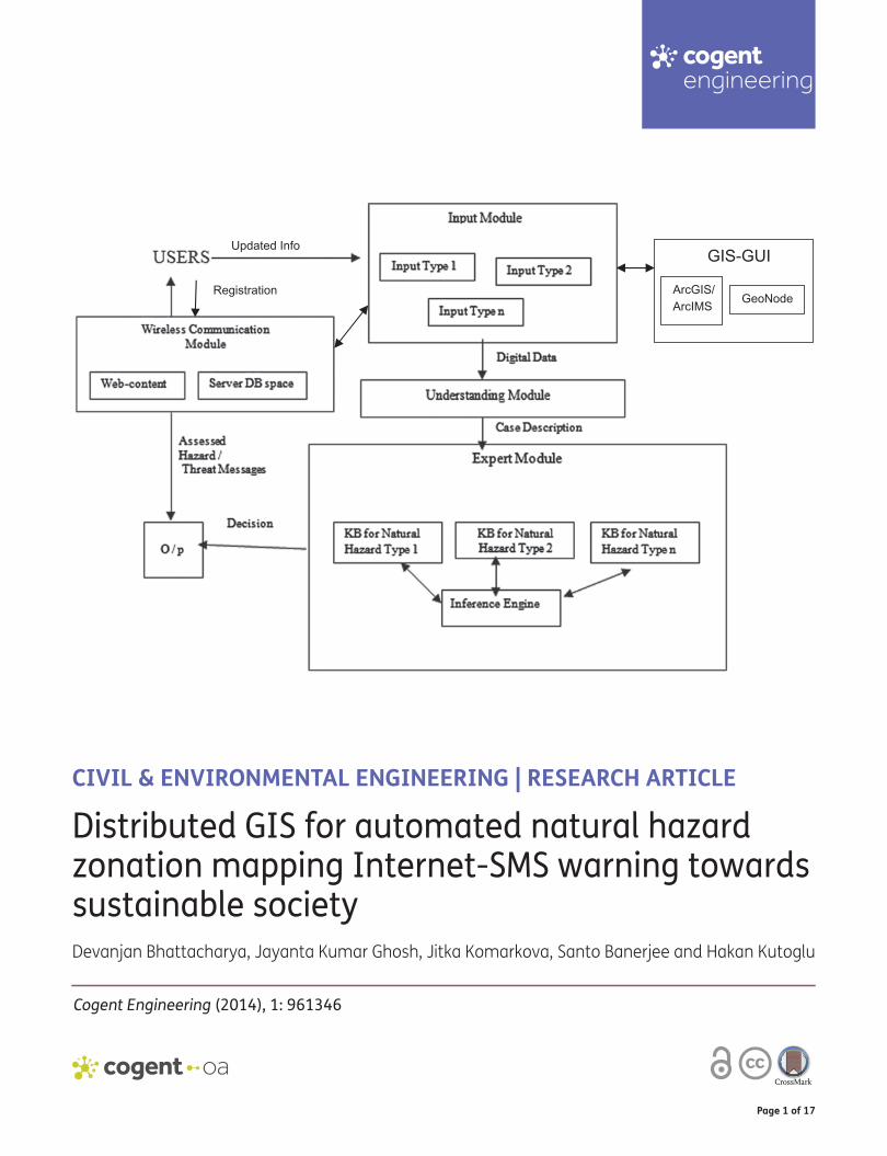
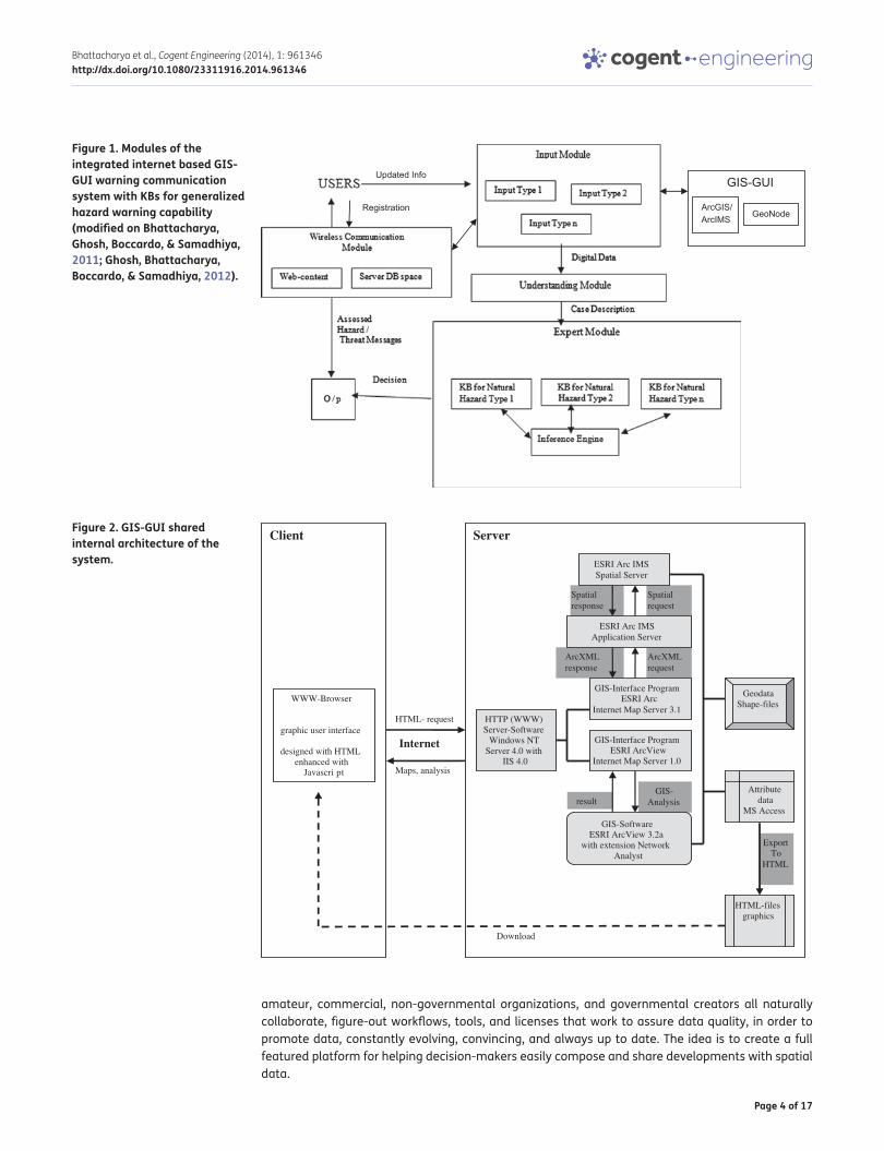
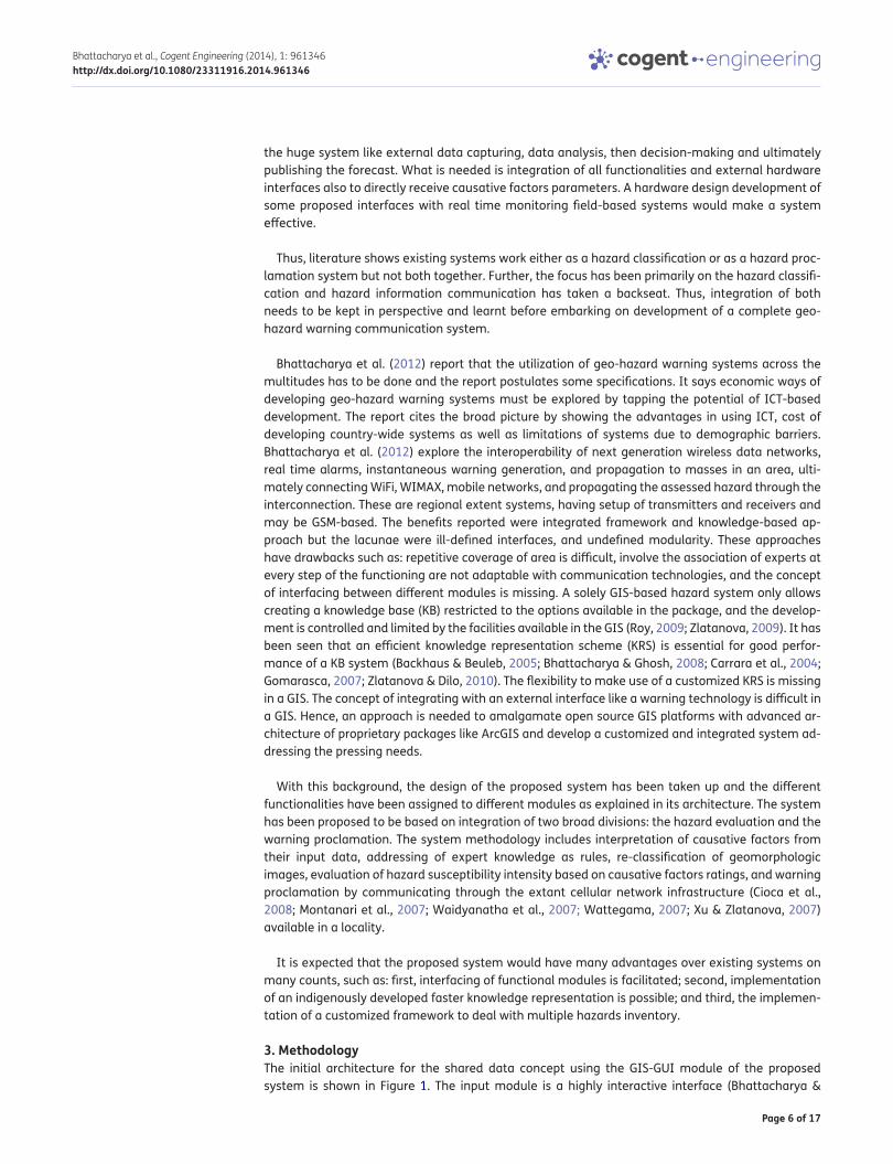
1. IntroductionA warning system capable of disseminating adequate and timely warning to the public is of great value. At present, hazard warning is communicated statically through telephone, television, radio, and internet but not through the short message service (SMS) (Pries, Hobfeld, & Gia, 2006). The increasing number of mobile phone subscriptions, around five billion worldwide, shows that a large number of persons can be reached via a mobile phone service through SMS (Cioca, Cioca, & Buraga, 2008). Real time analysis and warnings on geo-hazards can be issued using Open Source Geographical Information System (GIS)-based platform such as GeoNode allowing a graphical user interface (GUI) and which could be contributed to by developers around the world. To develop on an open source platform is a very vital component for better disaster information management as far as spatial data infrastructures (SDIs) are concerned and this would be extremely vital when huge databases are to be created and consulted regularly for city planning at different scales particularly satellite images and maps of locations. There is a big need for spatially referenced data creation, analysis, and management. Some of the salient points that this research would be able to definitely contribute with GeoNode being an open source platform are facilitating the creation, sharing, and collaborative use of geospatial data and benefitting masses by real-time communication (Figure 1).
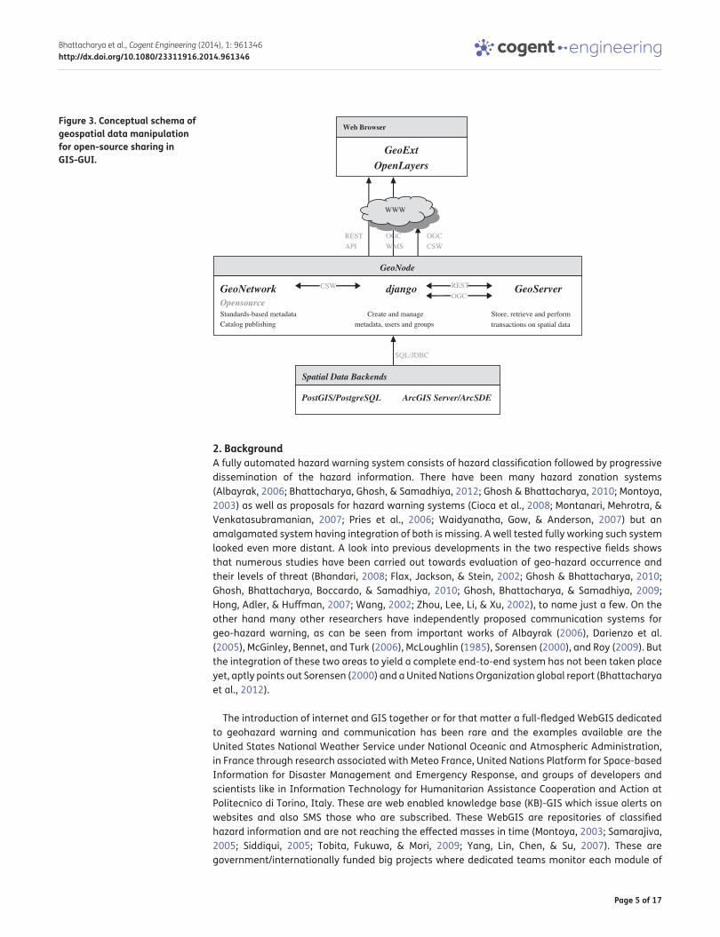
The research is aimed to create a dynamic and real-time SDI solution by the way of continual sharable activity imparted by internet and GeoNode (Figures 2 and 3). At its core, the system is based on open source components GeoServer, GeoNetwork, Django, and GeoExt, elaborated in Figure 3, that provide a platform for sophisticated web browser spatial visualization and analysis. Building on this stack, the present work utilizes a map composer and viewer, tools for analysis, and reporting tools which are facilitated by GeoNode. It is designed on Web 2.0 principles to make it extremely simple to share data; easily add comments, ratings, tags connecting between GeoNode and existing GIS tools. To enhance distribution, the GeoNode enables simple installation and distribution; auto-matic metadata creation; and search via catalogs and search engines. And to promote data collec-tion, the system is aimed to align incentives to create a sustainable SDI to align efforts so that
Page 4 of 17
Bhattacharya et al., Cogent Engineering (2014), 1: 961346http://dx.doi.org/10.1080/23311916.2014.961346
amateur, commercial, non-governmental organizations, and governmental creators all naturally collaborate, figure-out workflows, tools, and licenses that work to assure data quality, in order to promote data, constantly evolving, convincing, and always up to date. The idea is to create a full featured platform for helping decision-makers easily compose and share developments with spatial data.
Figure 1. Modules of the integrated internet based GIS-GUI warning communication system with KBs for generalized hazard warning capability (modified on Bhattacharya, Ghosh, Boccardo, & Samadhiya, 2011; Ghosh, Bhattacharya, Boccardo, & Samadhiya, 2012).
GIS-GUI
ArcGIS/ArcIMS GeoNode
Registration
Updated Info
Figure 2. GIS-GUI shared internal architecture of the system.
Maps, analysis
Internet
HTML- request
Server
GIS- Analysis
Client
WWW-Browser
graphic user interface
designed with HTML enhanced with
Javascri pt
HTTP (WWW) Server-Software
Windows NT Server 4.0 with
IIS 4.0
GIS-Interface Program ESRI ArcView
Internet Map Server 1.0
Geodata Shape-files
Attribute data
MS Access
HTML-filesgraphics
Download
Spatial response
Spatial request
ArcXML response
ArcXML request
GIS-Interface Program ESRI Arc
Internet Map Server 3.1
GIS-Software ESRI ArcView 3.2a
with extension Network Analyst
result
ExportTo
HTML
ESRI Arc IMS Spatial Server
ESRI Arc IMS Application Server
Page 5 of 17
Bhattacharya et al., Cogent Engineering (2014), 1: 961346http://dx.doi.org/10.1080/23311916.2014.961346
2. BackgroundA fully automated hazard warning system consists of hazard classification followed by progressive dissemination of the hazard information. There have been many hazard zonation systems (Albayrak, 2006; Bhattacharya, Ghosh, & Samadhiya, 2012; Ghosh & Bhattacharya, 2010; Montoya, 2003) as well as proposals for hazard warning systems (Cioca et al., 2008; Montanari, Mehrotra, & Venkatasubramanian, 2007; Pries et al., 2006; Waidyanatha, Gow, & Anderson, 2007) but an amalgamated system having integration of both is missing. A well tested fully working such system looked even more distant. A look into previous developments in the two respective fields shows that numerous studies have been carried out towards evaluation of geo-hazard occurrence and their levels of threat (Bhandari, 2008; Flax, Jackson, & Stein, 2002; Ghosh & Bhattacharya, 2010; Ghosh, Bhattacharya, Boccardo, & Samadhiya, 2010; Ghosh, Bhattacharya, & Samadhiya, 2009; Hong, Adler, & Huffman, 2007; Wang, 2002; Zhou, Lee, Li, & Xu, 2002), to name just a few. On the other hand many other researchers have independently proposed communication systems for geo-hazard warning, as can be seen from important works of Albayrak (2006), Darienzo et al. (2005), McGinley, Bennet, and Turk (2006), McLoughlin (1985), Sorensen (2000), and Roy (2009). But the integration of these two areas to yield a complete end-to-end system has not been taken place yet, aptly points out Sorensen (2000) and a United Nations Organization global report (Bhattacharya et al., 2012).
The introduction of internet and GIS together or for that matter a full-fledged WebGIS dedicated to geohazard warning and communication has been rare and the examples available are the United States National Weather Service under National Oceanic and Atmospheric Administration, in France through research associated with Meteo France, United Nations Platform for Space-based Information for Disaster Management and Emergency Response, and groups of developers and scientists like in Information Technology for Humanitarian Assistance Cooperation and Action at Politecnico di Torino, Italy. These are web enabled knowledge base (KB)-GIS which issue alerts on websites and also SMS those who are subscribed. These WebGIS are repositories of classified hazard information and are not reaching the effected masses in time (Montoya, 2003; Samarajiva, 2005; Siddiqui, 2005; Tobita, Fukuwa, & Mori, 2009; Yang, Lin, Chen, & Su, 2007). These are government/internationally funded big projects where dedicated teams monitor each module of
Figure 3. Conceptual schema of geospatial data manipulation for open-source sharing in GIS-GUI.
GeoNode
Spatial Data Backends
GeoExt OpenLayers
GeoNetwork django GeoServerOpensource
Store, retrieve and perform metadata, users and groups
WWW
ArcGIS Server/ArcSDE PostGIS/PostgreSQL
Web Browser
SQL/JDBC
OGC CSW
REST API
OGC WMS
CSW RESTOGC
Standards-based metadata Create and managetransactions on spatial data Catalog publishing
Page 6 of 17
Bhattacharya et al., Cogent Engineering (2014), 1: 961346http://dx.doi.org/10.1080/23311916.2014.961346
the huge system like external data capturing, data analysis, then decision-making and ultimately publishing the forecast. What is needed is integration of all functionalities and external hardware interfaces also to directly receive causative factors parameters. A hardware design development of some proposed interfaces with real time monitoring field-based systems would make a system effective.
Thus, literature shows existing systems work either as a hazard classification or as a hazard proc-lamation system but not both together. Further, the focus has been primarily on the hazard classifi-cation and hazard information communication has taken a backseat. Thus, integration of both needs to be kept in perspective and learnt before embarking on development of a complete geo-hazard warning communication system.
Bhattacharya et al. (2012) report that the utilization of geo-hazard warning systems across the multitudes has to be done and the report postulates some specifications. It says economic ways of developing geo-hazard warning systems must be explored by tapping the potential of ICT-based development. The report cites the broad picture by showing the advantages in using ICT, cost of developing country-wide systems as well as limitations of systems due to demographic barriers. Bhattacharya et al. (2012) explore the interoperability of next generation wireless data networks, real time alarms, instantaneous warning generation, and propagation to masses in an area, ulti-mately connecting WiFi, WIMAX, mobile networks, and propagating the assessed hazard through the interconnection. These are regional extent systems, having setup of transmitters and receivers and may be GSM-based. The benefits reported were integrated framework and knowledge-based ap-proach but the lacunae were ill-defined interfaces, and undefined modularity. These approaches have drawbacks such as: repetitive coverage of area is difficult, involve the association of experts at every step of the functioning are not adaptable with communication technologies, and the concept of interfacing between different modules is missing. A solely GIS-based hazard system only allows creating a knowledge base (KB) restricted to the options available in the package, and the develop-ment is controlled and limited by the facilities available in the GIS (Roy, 2009; Zlatanova, 2009). It has been seen that an efficient knowledge representation scheme (KRS) is essential for good perfor-mance of a KB system (Backhaus & Beuleb, 2005; Bhattacharya & Ghosh, 2008; Carrara et al., 2004; Gomarasca, 2007; Zlatanova & Dilo, 2010). The flexibility to make use of a customized KRS is missing in a GIS. The concept of integrating with an external interface like a warning technology is difficult in a GIS. Hence, an approach is needed to amalgamate open source GIS platforms with advanced ar-chitecture of proprietary packages like ArcGIS and develop a customized and integrated system ad-dressing the pressing needs.
With this background, the design of the proposed system has been taken up and the different functionalities have been assigned to different modules as explained in its architecture. The system has been proposed to be based on integration of two broad divisions: the hazard evaluation and the warning proclamation. The system methodology includes interpretation of causative factors from their input data, addressing of expert knowledge as rules, re-classification of geomorphologic images, evaluation of hazard susceptibility intensity based on causative factors ratings, and warning proclamation by communicating through the extant cellular network infrastructure (Cioca et al., 2008; Montanari et al., 2007; Waidyanatha et al., 2007; Wattegama, 2007; Xu & Zlatanova, 2007) available in a locality.
It is expected that the proposed system would have many advantages over existing systems on many counts, such as: first, interfacing of functional modules is facilitated; second, implementation of an indigenously developed faster knowledge representation is possible; and third, the implemen-tation of a customized framework to deal with multiple hazards inventory.
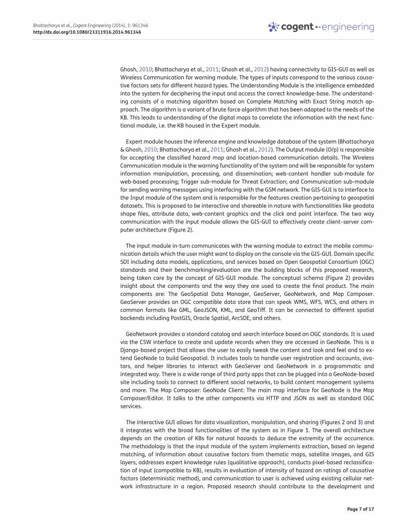
3. MethodologyThe initial architecture for the shared data concept using the GIS-GUI module of the proposed system is shown in Figure 1. The input module is a highly interactive interface (Bhattacharya &
Page 7 of 17
Bhattacharya et al., Cogent Engineering (2014), 1: 961346http://dx.doi.org/10.1080/23311916.2014.961346
Ghosh, 2010; Bhattacharya et al., 2011; Ghosh et al., 2012) having connectivity to GIS-GUI as well as Wireless Communication for warning module. The types of inputs correspond to the various causa-tive factors sets for different hazard types. The Understanding Module is the intelligence embedded into the system for deciphering the input and access the correct knowledge-base. The understand-ing consists of a matching algorithm based on Complete Matching with Exact String match ap-proach. The algorithm is a variant of brute force algorithm that has been adapted to the needs of the KB. This leads to understanding of the digital maps to correlate the information with the next func-tional module, i.e. the KB housed in the Expert module.
Expert module houses the inference engine and knowledge database of the system (Bhattacharya & Ghosh, 2010; Bhattacharya et al., 2011; Ghosh et al., 2012). The Output module (O/p) is responsible for accepting the classified hazard map and location-based communication details. The Wireless Communication module is the warning functionality of the system and will be responsible for system information manipulation, processing, and dissemination; web-content handler sub-module for web-based processing; Trigger sub-module for Threat Extraction; and Communication sub-module for sending warning messages using interfacing with the GSM network. The GIS-GUI is to interface to the Input module of the system and is responsible for the features creation pertaining to geospatial datasets. This is proposed to be interactive and shareable in nature with functionalities like geodata shape files, attribute data, web-content graphics and the click and point interface. The two way communication with the input module allows the GIS-GUI to effectively create client–server com-puter architecture (Figure 2).
The input module in-turn communicates with the warning module to extract the mobile commu-nication details which the user might want to display on the console via the GIS-GUI. Domain specific SDI including data models, applications, and services based on Open Geospatial Consortium (OGC) standards and their benchmarking/evaluation are the building blocks of this proposed research, being taken care by the concept of GIS-GUI module. The conceptual schema (Figure 2) provides insight about the components and the way they are used to create the final product. The main components are: The GeoSpatial Data Manager, GeoServer, GeoNetwork, and Map Composer. GeoServer provides an OGC compatible data store that can speak WMS, WFS, WCS, and others in common formats like GML, GeoJSON, KML, and GeoTiff. It can be connected to different spatial backends including PostGIS, Oracle Spatial, ArcSDE, and others.
GeoNetwork provides a standard catalog and search interface based on OGC standards. It is used via the CSW interface to create and update records when they are accessed in GeoNode. This is a Django-based project that allows the user to easily tweak the content and look and feel and to ex-tend GeoNode to build Geospatial. It includes tools to handle user registration and accounts, ava-tars, and helper libraries to interact with GeoServer and GeoNetwork in a programmatic and integrated way. There is a wide range of third party apps that can be plugged into a GeoNode-based site including tools to connect to different social networks, to build content management systems and more. The Map Composer: GeoNode Client: The main map interface for GeoNode is the Map Composer/Editor. It talks to the other components via HTTP and JSON as well as standard OGC services.
The interactive GUI allows for data visualization, manipulation, and sharing (Figures 2 and 3) and it integrates with the broad functionalities of the system as in Figure 1. The overall architecture depends on the creation of KBs for natural hazards to deduce the extremity of the occurrence. The methodology is that the input module of the system implements extraction, based on legend matching, of information about causative factors from thematic maps, satellite images, and GIS layers, addresses expert knowledge rules (qualitative approach), conducts pixel-based reclassifica-tion of input (compatible to KB), results in evaluation of intensity of hazard on ratings of causative factors (deterministic method), and communication to user is achieved using existing cellular net-work infrastructure in a region. Proposed research should contribute to the development and
Page 8 of 17
Bhattacharya et al., Cogent Engineering (2014), 1: 961346http://dx.doi.org/10.1080/23311916.2014.961346
application of OGC standards. The proposal brings out the benefits of the study towards these goals and the overall requirement of setting up of SDIs in the country.
The proposed system architecture is based on the concepts of interactivity between geo-spatial data management, internet and web-based processing, logical inferencing, and communication technology. Hence the development of different modules, each of which achieves a specific set of tasks related to the mentioned technologies, such as the data needed by the geo-hazard warning communication system and the structure of data maintenance adopted inside the database module.
3.1. Input data to the systemThe data utilized by the system comes in many basic formats like string, numeric, alphanumeric, and arrays. The aggregated data are stored in the database as geo-referenced data, threat strings, com-munication numbers, and instructive messages if any. The data-sets required by the geo-hazard warning communication system are as follows:
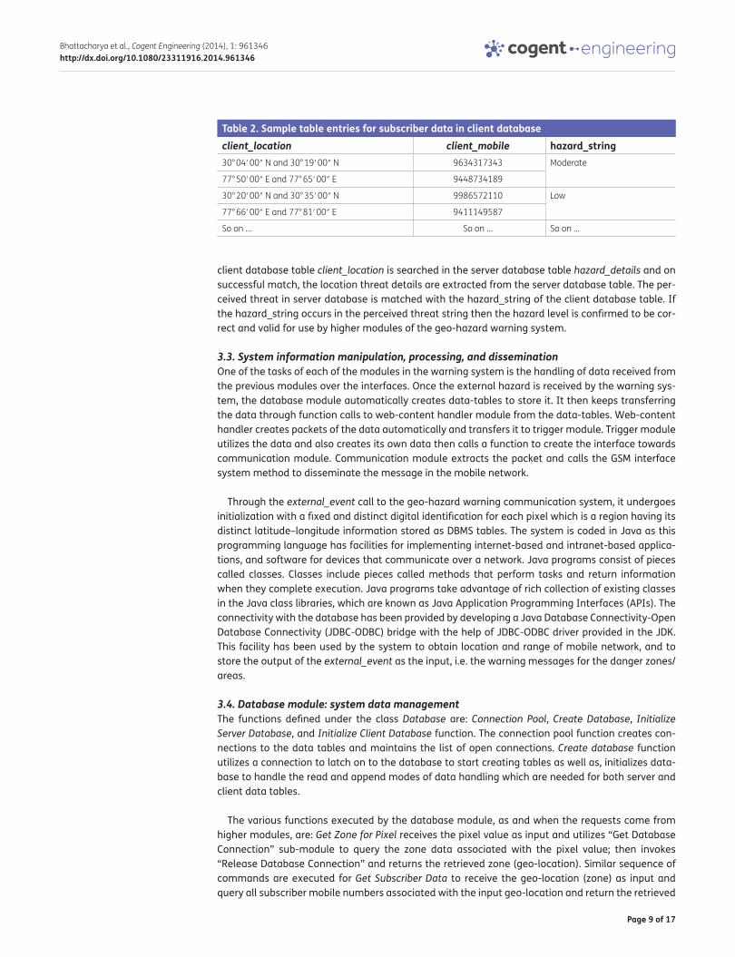
3.2. Geo-referenced dataThe information pertaining to assessed hazard and subscriber mobile data those have been regis-tered in the system and mapped to the region (geo-referenced threat locations) where the mes-sages are to be disseminated. The validation procedure works on landslide threat in a region evaluated a priory as a hazard map. The mobile numbers to be utilized for sending messages are the numbers lying in the region of the map. There could be many maps whose threat data are stored in the database of the warning system at any given time. To select the correct mobile numbers for that region, the hazard location as well as subscriber data both have been geo-referenced. The latitude and longitude for a given location describes the threat level in that location in one table and the same latitude–longitude describes the mobile numbers in that region. The separation of regions has been kept as .25° × .25° latitude × longitude. The latitude–longitude combination has been used as indexes for accessing the tables in the database.
3.2.1. Location dataThe location data consists of spatial as well as the threat details of an area, contained in the server database. The server database holds in its table hazard_details threat messages in association with their geo-location (Table 1). The index column represents the pixel location of the rasterized hazard data having geo-referenced match with the ground location shown in the second column of the table. The classified hazard description constitutes the third column of the table which notifies the local area name as well. The geo-location in the second column is accessed by the client table described next.
3.2.2. Subscriber dataThe subscriber data consists of the spatial details and the mobile numbers existing in that area, and populated with registered users (Table 2). The client database stores the subscribers’ registered mobile numbers in association with their geo-locations in a manner which corresponds to the format that the server database stores its geo-locations. Each entry from the first column of the
Table 1. Sample table entries for location data in server databaseIndex Ground location Perceived threat at that location0 0 0 0 0 0 30° 04′ 00″ N and 30° 19′ 00″ N Moderate landslide threat in Devaprayag
77° 50′ 00″ E and 77° 65′ 00″ E
0 1 0 0 2 0 30° 20′ 00″ N and 30° 35′ 00″ N Low landslide threat in Muni ki reti
77° 66′ 00″ E and 77° 81′ 00″ E
So on … So on … So on …
Page 9 of 17
Bhattacharya et al., Cogent Engineering (2014), 1: 961346http://dx.doi.org/10.1080/23311916.2014.961346
client database table client_location is searched in the server database table hazard_details and on successful match, the location threat details are extracted from the server database table. The per-ceived threat in server database is matched with the hazard_string of the client database table. If the hazard_string occurs in the perceived threat string then the hazard level is confirmed to be cor-rect and valid for use by higher modules of the geo-hazard warning system.
3.3. System information manipulation, processing, and disseminationOne of the tasks of each of the modules in the warning system is the handling of data received from the previous modules over the interfaces. Once the external hazard is received by the warning sys-tem, the database module automatically creates data-tables to store it. It then keeps transferring the data through function calls to web-content handler module from the data-tables. Web-content handler creates packets of the data automatically and transfers it to trigger module. Trigger module utilizes the data and also creates its own data then calls a function to create the interface towards communication module. Communication module extracts the packet and calls the GSM interface system method to disseminate the message in the mobile network.
Through the external_event call to the geo-hazard warning communication system, it undergoes initialization with a fixed and distinct digital identification for each pixel which is a region having its distinct latitude–longitude information stored as DBMS tables. The system is coded in Java as this programming language has facilities for implementing internet-based and intranet-based applica-tions, and software for devices that communicate over a network. Java programs consist of pieces called classes. Classes include pieces called methods that perform tasks and return information when they complete execution. Java programs take advantage of rich collection of existing classes in the Java class libraries, which are known as Java Application Programming Interfaces (APIs). The connectivity with the database has been provided by developing a Java Database Connectivity-Open Database Connectivity (JDBC-ODBC) bridge with the help of JDBC-ODBC driver provided in the JDK. This facility has been used by the system to obtain location and range of mobile network, and to store the output of the external_event as the input, i.e. the warning messages for the danger zones/areas.
3.4. Database module: system data managementThe functions defined under the class Database are: Connection Pool, Create Database, Initialize Server Database, and Initialize Client Database function. The connection pool function creates con-nections to the data tables and maintains the list of open connections. Create database function utilizes a connection to latch on to the database to start creating tables as well as, initializes data-base to handle the read and append modes of data handling which are needed for both server and client data tables.
The various functions executed by the database module, as and when the requests come from higher modules, are: Get Zone for Pixel receives the pixel value as input and utilizes “Get Database Connection” sub-module to query the zone data associated with the pixel value; then invokes “Release Database Connection” and returns the retrieved zone (geo-location). Similar sequence of commands are executed for Get Subscriber Data to receive the geo-location (zone) as input and query all subscriber mobile numbers associated with the input geo-location and return the retrieved
Table 2. Sample table entries for subscriber data in client databaseclient_location client_mobile hazard_string30° 04′ 00″ N and 30° 19′ 00″ N 9634317343 Moderate
77° 50′ 00″ E and 77° 65′ 00″ E 9448734189
30° 20′ 00″ N and 30° 35′ 00″ N 9986572110 Low
77° 66′ 00″ E and 77° 81′ 00″ E 9411149587
So on … So on … So on …
Page 10 of 17
Bhattacharya et al., Cogent Engineering (2014), 1: 961346http://dx.doi.org/10.1080/23311916.2014.961346
subscriber mobile numbers for the zone. Get Location Threat Level receives the geo-location (zone) as input and runs the query to access the threat level associated with the input geo-location and returns the retrieved threat message. Likewise there are other procedures for insertion, authentica-tion and storage of server (operator) and client (subscriber) data available to the database module.
3.5. Web-content handler module: web-based processingThe web-content handler in the warning system application is based on a web platform. Data trans-mission security is ensured by using the HTTP-Secured, which provides a secure channel between the client station and the system residing on the server. The proposed warning communication system, being web-based, has interfaces through the external events of hazard classification, local servers, the internet and the warning system server. Web-content handler module has defined classes Initialize GUI, Create New Subscriber, and User Login for managing various data processing and transmission tasks. These classes have further sub-divided tasks as methods and functions. The information exchange in the warning system starts from receiving the hazard classification of an area, storing it in the local server, invoking the web-content handler which is internet-resident using HTTP connection, selecting the mobile numbers stored in the system server, utilizing the trigger conditions for checking the level of threats, and finally, calling the communication module to dis-seminate the message. The telecommunication commands handle the modem functionality and thus the communication with the mobiles gets established.
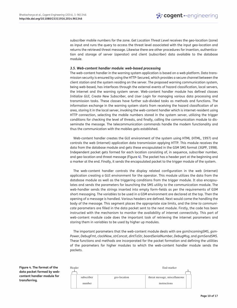
Web-content handler creates the GUI environment of the system using HTML (HTML, 1997) and controls the web (internet) application data transmission applying HTTP. This module receives the data from the database module and gets these encapsulated in the GSM SMS format (3GPP, 1998). Independent packet gets formed for each location consisting of, in sequence, subscriber number, and geo-location and threat message (Figure 4). The packet has a header part at the beginning and a marker at the end. Finally, it sends the encapsulated packet to the trigger module of the system.
The web-content handler controls the display related configuration in the web (internet) application creating a GUI environment for the operator. This module utilizes the data from the database module as well as the triggering conditions from the trigger module. It also encapsu-lates and sends the parameters for launching the SMS utility to the communication module. The web-handler sends the strings inserted into empty form-fields as per the requirements of GSM short messaging. The variables to be used in a GSM environment are declared at the top. Then the opening of a message is handled. Various headers are defined. Next would come the handling the body of the message. This segment places the appropriate size limits, and the time to communicate parameters are filled in the data packet sent to the next module. Firstly, the code has been instructed with the mechanism to monitor the availability of internet connectivity. This part of web-content module code does the important task of retrieving the internet parameters and storing them in variables to be used by higher up modules.
The important parameters that the web-content module deals with are gsmIncomingSMS, gsmPower, DebugFmt, clockNow, strConcat, dintToStr, boardSerialNumber, DebugMsg, and gsmSendSMS. These functions and methods are incorporated for the packet formation and defining the utilities of the parameters for higher modules to which the web-content handler module sends the packets.
Figure 4. The format of the data packet formed by web-content handler module for transferring.
Header
subscriber
number
threat message, miscellaneous
instructions
End-marker
geo-location
Page 11 of 17
Bhattacharya et al., Cogent Engineering (2014), 1: 961346http://dx.doi.org/10.1080/23311916.2014.961346
3.6. Trigger module: threat extractionThe trigger module holds the logic and the algorithm to check that the correct string is being sent as SMS. The level of hazard (at present, there are three levels of hazards, such as low, moderate, and high) is stored as a string which comes from the server database. This string is identified as high or moderate or low and accordingly is determined the trigger to be generated. Trigger module accepts the encapsulated information packet from web-content handler and extracts the appropriate mes-sage for a geo-location and passes it on as a parameter passing mechanism to the communication module. Trigger module has the declarations for setting the THREAT_TO_SMS_FREQUENCY_MAPPING variable which contains the mapping between threat level and frequency of SMS, for defining Process Information Packet sub-module, for Searching and Matching sub-module, for Set SMS Frequency sub-module, and defining Trigger Hazard Warning sub-module.
The mapping variable transfers the value assigned for message dissemination for each level of threat. The process information packet sub-module contains codes for executing the packet data processing tasks. The searching and matching sub-module performs the string operations to search for hazard level and come to a conclusion about the threat. Set SMS Frequency sub-module modifies the packet with new data of frequency of dissemination. Finally, the Trigger Hazard Warning sub-module sends the triggered packet to communication module. The various events taking place in the execution of the trigger-module are, the external event—an event that requires a warning alert (landslide, flooding, etc.); the initiator: part of code that acknowledges and identifies the external event and sends the alert request to the handler; the main method: is invoked in the server where the request is processed; and subsequently is executed the GSM Method which is a specialized soft-ware component that transfers the alert message to the communication module for propagating over mobile communication network.
3.7. Communication module: sending warning messagesThe communication module is responsible for sending the warning messages and hence defines parameters such as definition of DELIVERY_MODE variable to either of INTERNET_SOFTWARE or SELF_HARDWARE, and further defining internet broadcast to mobiles. Finally, the module defines and ex-ecutes Send SMS sub-module. Send SMS accepts the subscriber mobile numbers, zone, associated threat message, and SMS frequency as input parameters, validates the input parameters, and initial-izes a parameter called ROUND_NUMBER to 1 which is meant to execute rounds of hazard warning dissemination. The following steps are processed while ROUND_NUMBER is less than or equal to the value contained in variable SMS frequency:
display the ROUND_NUMBER of the SMS being sent in the client GUI
if DELIVERY_MODE is internet broadcast
call “Send SMS INTERNET_SOFTWARE”
else if DELIVERY_MODE is SELF_HARDWARE
call “Send SMS SELF_HARDWARE” sub-module
else
DELIVERY_MODE is not specified, display error message to user
display the status of SMS sent in client GUI
increment ROUND_NUMBER variable by 1
The communication module receives packet consisting of subscriber number, threat message, and SMS frequency, in sequence. The primary objective of the communication module is to open the SMS sending utility and ensure that the communication goes through the correct gateway. The gateway is responsible for channeling data from internet to mobile network. The network
Page 12 of 17
Bhattacharya et al., Cogent Engineering (2014), 1: 961346http://dx.doi.org/10.1080/23311916.2014.961346
communication broadcast facility will be used to freely send SMS to all users of mobiles moving into an area affected and perceived threat prone. The SMS sending utility is invoked/opened by the com-munication module and is entered with the initial parameters such as username, password and application identity (API ID). These initial parameters are required for authorizing the delivery of each SMS, hence the communication module inserts these parameters into the SMS program each time the program is called.
The warning system uses the location details from the server database and accesses the threat message strings corresponding to each. In its client database, the warning module has the mobile numbers in a pre-determined storage format. Hence, as soon as the mobile numbers in the region are extracted from the table, the SMS Protocol program is called and the mobile numbers filled in the program as command line parameters and the respective hazard messages are sent. The number of mobile numbers selected per region is fed in a loop and the SMS program is called for each number for sending SMS.
The SMS program connects to the SMS gateway via the internet and this gateway forwards the text message to the mobile environment. The steps correspond to the logic of sending an SMS. The first step is to verify the user. The second step consists of creating the SMS message body including gsm_number, sender_name, text_message, name_of_packet, gateway_identification, quality_of_message, and delivery_code. These ensure that the message is delivered correctly; if not then appropriate negative acknowledgment is sent. In the flow of controls, it can be seen that it is mandatory to create a connection and close it upon exit each time SMS is to be sent. After opening a connection, login can be proceeded to, and if login is positive then SMS sending is allowed. Upon detecting the final header of SMS the connection is closed.
3.8. Interfacing with the GSM networkThe internal processing involving the database and web servers maintains the actual data flow con-trolled by the http/s and TCP/IP commands. When an http request is generated by the system after creating the data packet, server hosting web-content module starts processing the requests and accesses the database through a TCP/IP channel. Further internal processing involves the function calls in sequential manner to the trigger module and communication module. The communication module executes the server command ComX (present in attention (AT) command-set) to connect to the modem over a physical channel RS232.
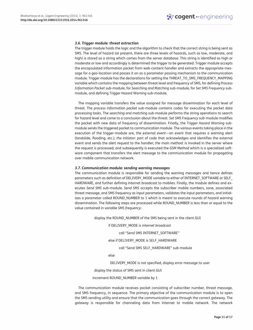
The AT (attention/initiate) communication protocol command-set is a terminal protocol (Cioca et al., 2008). The protocol activates the modem and directly issues modem commands. It facilitates sending of SMS by executing the AT communication protocol command-set. The procedure consists of typing several text commands in a terminal window (Figure 5). The first command shown initial-izes the modem connection, then the mode is set to SMS mode, after that the commands setup the message parameters like size and headers. In order to transmit a text message (SMS) through mo-dem specific instructions are used on the serial interface.
The AT commands follow a sequence as per the logic within the system. The logical steps of sending an SMS are as follows: the first step verifies the authenticity of the user. In the second step, appropriate SMS message body (consisting of gsm_number, sender_name, text_message, name_of_packet, gateway_identification, quality_of_message, and delivery_code) is created to ensure the message gets delivered to correct users. And if not, then negative acknowledgment gets sent. As soon as a message is ready to be sent, a connection gets opened, for permissible login SMS gets sent and on detecting the final header of SMS, the connection is closed. The cycle repeats for each SMS.
Hence, as soon as the mobile numbers in the region are extracted from the table, the SMS protocol program is called and the mobile numbers filled in the program as command line parameters and
Page 13 of 17
Bhattacharya et al., Cogent Engineering (2014), 1: 961346http://dx.doi.org/10.1080/23311916.2014.961346
the respective hazard messages are sent. The number of mobile numbers selected per region is fed in a loop and the SMS program is called for each number for sending SMS. The SMS program connects to the SMS gateway via the internet and this gateway forwards the message to the mobile numbers.
And subsequently, the GSM_Method is executed which provides interfacing between the communication module and external GSM environment. It transfers the alert message from the communication module over mobile communication network. The telecommunication com-mands handle the modem functionality and thus the communication with the mobiles gets established and hence providing interfacing. The GSM method also sends the strings to be in-serted into empty form-fields as per the requirements of GSM short messaging. The variables to be used in a GSM environment are declared at the initiation of the GSM program. Next, the pro-gram handles the opening of a message. Various headers are defined within the body of the program. Next in the program is the section of the code that handles the body of the message. This segment places the appropriate size limits, and the time to communicate parameters are filled in the SMS technical specifications.
The communication module is equipped with two ways of interfacing with the GSM network to send SMS messages from the warning system to mobile phones. The two methods are:
(1) Connectivity of the geo-hazard warning system to the SMS center (SMSC) or SMS gateway of a wireless carrier or SMS service provider through the internet. Subsequently the communication module sends SMS messages using a protocol/interface supported by the SMSC or SMS gate-way. This is the software method of message sending.
(2) Connectivity of GSM modem to the geo-hazard warning system and execution of AT com-mands to instruct the GSM modem to send SMS messages. This is the hardware method.
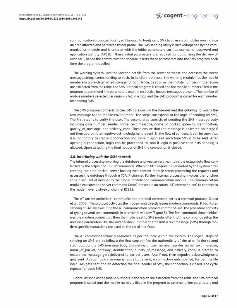
The SMS gateway is the responsible entity to disseminate messages in an SMS messaging system. Hence, the developed system utilizes programming interfaces to SMS gateway (Figure 6) using an open source SMS gateway software package Kannel (2010), which is programmable. Through Kannel, the geo-hazard warning communication system can handle connections to SMSCs, mobile phones, and GSM modems. It has an HTTP/HTTPS interface for the sending and receiving of SMS messages.
Figure 5. A snapshot of AT commands for sending warning SMSs in GSM network.
AT : Initiate modem connection
OK : Result
AT+CMFG=1 : Setting mode – SMS Mode
OK : Result
AT+CMGW=“+0742****” : Setting Number
>Example Text : Message ends with Ctrl Z
+CMGW: 1 : Message Index
OK : Result
AT+CMSS=1 : Send message
+CMSS:20 : Sent message index
OK : Result
Figure 6. SMS gateway acts as a relay between two SMSCs.
Page 14 of 17
Bhattacharya et al., Cogent Engineering (2014), 1: 961346http://dx.doi.org/10.1080/23311916.2014.961346
To connect to an SMS gateway, the developed system uses an SMSC protocol called Short Message Peer to Peer (SMPP). Some features of the developed SMS application are programmed using the HTTP/HTTPS interface also. HTTP/HTTPS are easier to use than SMSC protocol SMPP.
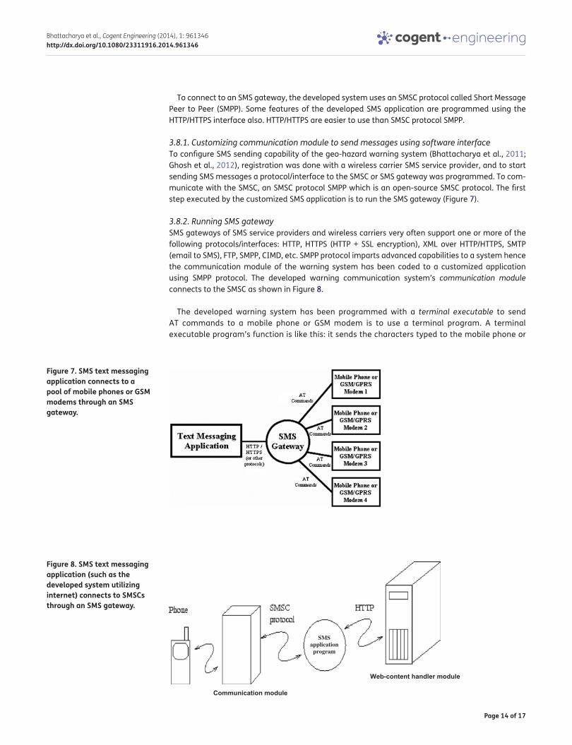
3.8.1. Customizing communication module to send messages using software interfaceTo configure SMS sending capability of the geo-hazard warning system (Bhattacharya et al., 2011; Ghosh et al., 2012), registration was done with a wireless carrier SMS service provider, and to start sending SMS messages a protocol/interface to the SMSC or SMS gateway was programmed. To com-municate with the SMSC, an SMSC protocol SMPP which is an open-source SMSC protocol. The first step executed by the customized SMS application is to run the SMS gateway (Figure 7).
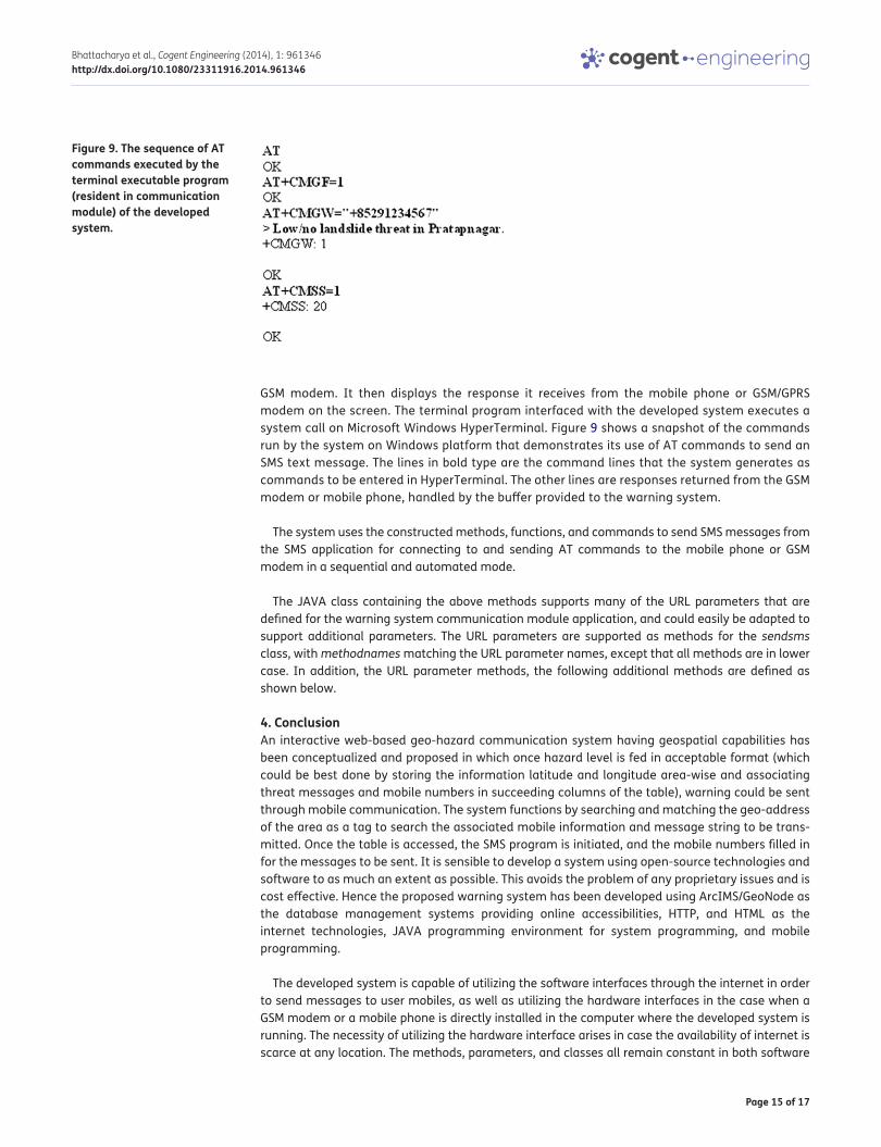
3.8.2. Running SMS gatewaySMS gateways of SMS service providers and wireless carriers very often support one or more of the following protocols/interfaces: HTTP, HTTPS (HTTP + SSL encryption), XML over HTTP/HTTPS, SMTP (email to SMS), FTP, SMPP, CIMD, etc. SMPP protocol imparts advanced capabilities to a system hence the communication module of the warning system has been coded to a customized application using SMPP protocol. The developed warning communication system’s communication module connects to the SMSC as shown in Figure 8.
The developed warning system has been programmed with a terminal executable to send AT commands to a mobile phone or GSM modem is to use a terminal program. A terminal executable program’s function is like this: it sends the characters typed to the mobile phone or
Figure 7. SMS text messaging application connects to a pool of mobile phones or GSM modems through an SMS gateway.
Figure 8. SMS text messaging application (such as the developed system utilizing internet) connects to SMSCs through an SMS gateway.
SMS application
program
Web-content handler module
Communication module
Page 15 of 17
Bhattacharya et al., Cogent Engineering (2014), 1: 961346http://dx.doi.org/10.1080/23311916.2014.961346
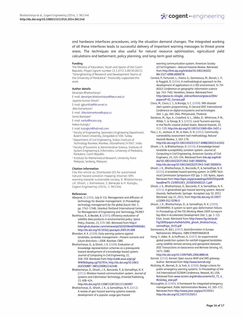
GSM modem. It then displays the response it receives from the mobile phone or GSM/GPRS modem on the screen. The terminal program interfaced with the developed system executes a system call on Microsoft Windows HyperTerminal. Figure 9 shows a snapshot of the commands run by the system on Windows platform that demonstrates its use of AT commands to send an SMS text message. The lines in bold type are the command lines that the system generates as commands to be entered in HyperTerminal. The other lines are responses returned from the GSM modem or mobile phone, handled by the buffer provided to the warning system.
The system uses the constructed methods, functions, and commands to send SMS messages from the SMS application for connecting to and sending AT commands to the mobile phone or GSM modem in a sequential and automated mode.
The JAVA class containing the above methods supports many of the URL parameters that are defined for the warning system communication module application, and could easily be adapted to support additional parameters. The URL parameters are supported as methods for the sendsms class, with methodnames matching the URL parameter names, except that all methods are in lower case. In addition, the URL parameter methods, the following additional methods are defined as shown below.
4. ConclusionAn interactive web-based geo-hazard communication system having geospatial capabilities has been conceptualized and proposed in which once hazard level is fed in acceptable format (which could be best done by storing the information latitude and longitude area-wise and associating threat messages and mobile numbers in succeeding columns of the table), warning could be sent through mobile communication. The system functions by searching and matching the geo-address of the area as a tag to search the associated mobile information and message string to be trans-mitted. Once the table is accessed, the SMS program is initiated, and the mobile numbers filled in for the messages to be sent. It is sensible to develop a system using open-source technologies and software to as much an extent as possible. This avoids the problem of any proprietary issues and is cost effective. Hence the proposed warning system has been developed using ArcIMS/GeoNode as the database management systems providing online accessibilities, HTTP, and HTML as the internet technologies, JAVA programming environment for system programming, and mobile programming.
The developed system is capable of utilizing the software interfaces through the internet in order to send messages to user mobiles, as well as utilizing the hardware interfaces in the case when a GSM modem or a mobile phone is directly installed in the computer where the developed system is running. The necessity of utilizing the hardware interface arises in case the availability of internet is scarce at any location. The methods, parameters, and classes all remain constant in both software
Figure 9. The sequence of AT commands executed by the terminal executable program (resident in communication module) of the developed system.
Page 16 of 17
Bhattacharya et al., Cogent Engineering (2014), 1: 961346http://dx.doi.org/10.1080/23311916.2014.961346
and hardware interfaces procedures, only the situation demand changes. The integrated working of all these interfaces leads to successful delivery of important warning messages to threat prone areas. The techniques are also useful for natural resource optimization, agricultural yield calculations and betterment, policy planning, and long-term goal setting.
FundingThe Ministry of Education, Youth and Sports of the Czech Republic, Project [grant number CZ.1.07/2.3.00/30.0021] “Strengthening of Research and Development Teams at the University of Pardubice”, financially supported this work.
Author detailsDevanjan Bhattacharya1
E-mail: [email protected] Kumar Ghosh2
E-mail: [email protected] Komarkova3
E-mail: [email protected] Banerjee4
E-mail: [email protected] Kutoglu1
E-mail: [email protected] Faculty of Engineering, Geomatics Engineering Department,
Bulent Ecevit University, Zonguldak 67100, Turkey.2 Department of Civil Engineering, Indian Institute of
Technology Roorkee, Roorkee, Uttarakhand 247667, India.3 Faculty of Economic & Administrative Science, Institute of
System Engineering & Informatics, University of Pardubice, Pardubice, Czech Republic.
4 Institute for Mathematical Research, University Putra Malaysia, Serdang, Malaysia.
Citation informationCite this article as: Distributed GIS for automated natural hazard zonation mapping Internet-SMS warning towards sustainable society, D. Bhattacharya, J.K. Ghosh, J. Komarkova, S. Banerjee & H. Kutoglu, Cogent Engineering (2014), 1: 961346.
ReferencesAlbayrak, O. (2006, July 9–13). Management and diffusion of
technology for disaster management. In Proceedings technology management for the global future (Vol. 1, pp. 1742–1748). Istanbul: Portland International Center for Management of Engineering and Technology, PICMET.
Backhaus, R., & Beuleb, B. (2005). Efficiency evaluation of satellite data products in environmental policy. Space Policy, Elsevier, 21, 173–183. Retrieved from http://linkinghub.elsevier.com/retrieve/pii/S0265964605000482; http://dx.doi.org/10.1016/j.spacepol.2005.05.008
Bhandari, R. K. (2008). Early warning systems against landslides, landslide management—Present scenario and future directions—2008. Roorkee: CBRI.
Bhattacharya, D., & Ghosh, J. K. (2008). Evaluation of knowledge representation schemes as a prerequisite toward development of a knowledge-based system. Journal of Computing in Civil Engineering, 22, 348–359. Retrieved from http://cedb.asce.org/cgi/WWWdisplay.cgi?167914; http://dx.doi.org/10.1061/(ASCE)0887-3801(2008)22:6(348)
Bhattacharya, D., Ghosh, J. K., Boccardo, P., & Samadhiya, N. K. (2011). Wireless hazard communication system. Journal of Systems and Information Technology, Emerald Publishing, 13, 408–424. http://dx.doi.org/10.1108/13287261111183997
Bhattacharya, D., Ghosh, J. K., & Samadhiya, N. K. (2012). A review of geo-hazard warning systems towards development of a popular usage geo-hazard
warning communication system. American Society of Civil Engineers—Natural Hazards Review. Retrieved from http://link.aip.org/link/doi/10.1061/(ASCE)NH.1527-6996.0000078
Carrara, P., Fortunati, L., Fresta, G., Gomarasca, M., Bonati, L. P., & Poggioli, D. (2004). A methodological approach to the development of applications in a SDI environment. In 7th AGILE Conference on geographic information science (pp. 743–746). Heraklion, Greece. Retrieved from http://plone.itc.nl/agile_old/conference/greece2004/papers/P-02_Carrara.pdf
Cioca, M., Cioca, L. I., & Buraga, S. C. (2008). SMS disaster alert system programming. In Second IEEE International Conference on digital ecosystems and technologies (Vol. 1, pp. 260–264). Phitsanulok, Thailand.
Darienzo, M., Aya, A., Crawford, G. L., Gibbs, D., Whitmore, P. M., Wilde, T., & Yanagi, B. S. (2005). Local Tsunami warning in the Pacific coastal United States. Natural Hazards, 35, 111–119. http://dx.doi.org/10.1007/s11069-004-2407-z
Flax, L. K., Jackson, R. W., & Stein, D. N. (2002). Community vulnerability assessment tool methodology. Natural Hazards Review, 3, 163–176. http://dx.doi.org/10.1061/(ASCE)1527-6988(2002)3:4(163)
Ghosh, J. K., & Bhattacharya, D. (2010). A knowledge based landslide susceptibility zonation system. Journal of Computing in Civil Engineering, American Society of Civil Engineers, 24, 325–334. Retrieved from link.aip.org/link/doi/10.1061/(ASCE)CP.1943-5487.0000034; http://dx.doi.org/10.1061/(ASCE)CP.1943-5487.0000034
Ghosh, J. K., Bhattacharya, D., Boccardo, P., & Samadhiya, N. K. (2010). A landslide hazard warning system. In ISPRS Technical Commission Symposium VIII (pp. 1–10). Kyoto, Japan. Retrieved from http://isprs.org/proceedings/XXXVIII/part8/headline/TS-23/W01OE3_2010030400224 1.pdf
Ghosh, J. K., Bhattacharya, D., Boccardo, P., & Samadhiya, N. K. (2012). A generalized geo-hazard warning system. Natural Hazards, Netherlands: Springer. Accepted July 10, 2012. Retrieved July 21, 2012, from http://dx.doi.org.10.1007/s11069-012-0296-0
Ghosh, J. K., Bhattacharya, D., & Samadhiya, N. K. (2009). GEOWARNS: A system to warn geo-deformation failure. In Proceedings of the FIG Working Week 2009 Surveyors Key Role in Accelerated Development (Vol. 1, pp. 1–12). Eilat, Israel. Retrieved from http://www.fig.net/pub/Fig2009/papers/ts04b/ts04b_ghosh_bhattacharya_samadhiya_3435.pdf
Gomarasca, M. (Ed.). (2007). GeoInformation in Europe. Netherlands: Millpress. ISBN 9789059660618
Hong, Y., Adler, R., & Huffman, G. (2007). An experimental global prediction system for rainfall-triggered landslides using satellite remote sensing and geospatial datasets. IEEE Transactions on Geoscience and Remote Sensing, 45, 1671–1680. http://dx.doi.org/10.1109/TGRS.2006.888436
Kannel. (2010). Kannel: Open source WAP and SMS gateway. Author. Retrieved from http://www.kannel.org/
McGinley, M., Bennet, D., & Turk, A. (2006). Design criteria for public emergency warning systems. In Proceedings of the 3rd International ISCRAM Conference, Newark, NJ, USA. Retrieved from www.iscram.org/dmdocuments/S2_T1_4_McGinley_etal.pdf
McLoughlin, D. (1985). A framework for integrated emergency management. Public Administration Review, 45, 165–172. Retrieved from http://www.jstor.org/pss/3135011 http://dx.doi.org/10.2307/3135011

Page 17 of 17
Bhattacharya et al., Cogent Engineering (2014), 1: 961346http://dx.doi.org/10.1080/23311916.2014.961346
© 2014 The Author(s). This open access article is distributed under a Creative Commons Attribution (CC-BY) 3.0 license.You are free to: Share — copy and redistribute the material in any medium or format Adapt — remix, transform, and build upon the material for any purpose, even commercially.The licensor cannot revoke these freedoms as long as you follow the license terms.
Under the following terms:Attribution — You must give appropriate credit, provide a link to the license, and indicate if changes were made. You may do so in any reasonable manner, but not in any way that suggests the licensor endorses you or your use. No additional restrictions You may not apply legal terms or technological measures that legally restrict others from doing anything the license permits.
Cogent Engineering (ISSN: 2331-1916) is published by Cogent OA, part of Taylor & Francis Group. Publishing with Cogent OA ensures:• Immediate, universal access to your article on publication• High visibility and discoverability via the Cogent OA website as well as Taylor & Francis Online• Download and citation statistics for your article• Rapid online publication• Input from, and dialog with, expert editors and editorial boards• Retention of full copyright of your article• Guaranteed legacy preservation of your article• Discounts and waivers for authors in developing regionsSubmit your manuscript to a Cogent OA journal at www.CogentOA.com
Montanari, M., Mehrotra, S., & Venkatasubramanian, N. (2007). Architecture for an automatic customized warning system. In IEEE Conference on intelligence security informatics (Vol. 1, pp. 32–39). New Brunswick, NJ.
Montoya, L. (2003). Geo-data acquisition through mobile GIS and digital video: An urban disaster management perspective. Environmental Modelling & Software, 18, 869–876.
Nayak, S., & Zlatanova, S. (2007). Remote sensing and GIS in disaster monitoring. Second Gi4DM Symposium GIM International, 21, 38–39.
Pries, R., Hobfeld, T., & Gia, P. T. (2006). On the suitability of the short message service for emergency warning systems. In Proceedings of the IEEE 63rd Vehicular Technology Conference (Vol. 2, pp. 991–995). Melbourne, Australia.
Roy, D. K. (2009). SATCOM—Early warning system for landslides. Electronics For You, 128–138. Retrieved from http://efylinux/efyhome/cover/January2009/Landslide-Monitoring.pdf
Samarajiva, R. (2005). Mobilizing information and communications technologies for effective disaster warning: Lessons from the 2004 Tsunami. New Media and Society, 7, 731–747. http://dx.doi.org/10.1177/1461444805058159
Siddiqui, A. (2005, March 9–11). Web‐GIS applications in disaster management—Application to the Tsunami. In National Seminar on GIS application in rural development with focus on disaster management. Hyderabad. Retrieved from http://faculty.kfupm.edu.sa/crp/bramadan/crp514/Lectures/9%20-%20Web-GIS.pdf
Sorensen, J. H. (2000). Hazard warning systems: Review of 20 years of progress. Natural Hazards Review, 1, 119–125. http://dx.doi.org/10.1061/(ASCE)1527-6988(2000)1:2(119)
Tobita, J., Fukuwa, N., & Mori, M. (2009). Integrated disaster simulator using WebGIS and its application to community disaster mitigation activities. Journal of Natural Disaster Science, 30, 71–82. Retrieved from http://www.jsnds.org/contents/jnds/30_2_3.pdf
Waidyanatha, N., Gow, G., & Anderson, P. (2007). Hazard warnings in Sri Lanka: Challenges of internetworking with common alerting protocol. In 4th International ISCRAM Conference (Vol. 1, pp. 281–293). Delft, The Netherlands.
Wang, Y. (2002). Mapping extent of floods: What we have learned and how we can do better. Natural Hazards Review, 3, 68–73. http://dx.doi.org/10.1061/(ASCE)1527-6988(2002)3:2(68)
Wattegama, C. (2007). ICT for disaster management. Retrieved April 15, 2008, from www.apdip.net/publications/iespprimers/eprimer-dm.pdf
Xu, W., & Zlatanova, S. (2007). Ontologies for disaster management. In Geomatics solutions for disaster management, lecture notes in geoinformation and cartography (pp. 185–200). Heidelberg: Springer-Verlag Berlin. Retrieved from http://www.gdmc.nl/zlatanova/thesis/html/refer/ps/WX_SZ_2007.pdf
Yang, M. D., Lin, C. C., Chen, S. C., & Su, T. C. (2007, November 27–29). A Web-GIS disaster management system applied in central Taiwan. In 2nd International Conference on urban disaster reduction. Retrieved from http://ncdr.nat.gov.tw/2icudr/2icudr_cd/PDF/5_1_5.pdf
Zhou, C. H., Lee, C. F., Li, J., & Xu, Z. W. (2002). On the spatial relationship between landslides and causative factors. Geomorphology, 43, 197–207. http://dx.doi.org/10.1016/S0169-555X(01)00130-1
Zlatanova, S. (2009). Geoinformation for disaster management. GIM International (Vol. 23/7, ISPRS column). Retrieved from http://www.gim-international.com/issues/articles/id1391-Geoinformation_for_Disaster_Manage-ment.html
Zlatanova, S., & Dilo, A. (2010, February). A data model for operational and situational information in emergency response: The Dutch case. In Proceedings of the Gi4DM Conference—Geomatics for Disaster Management (p. 4). Torino. Retrieved from www.gdmc.nl/publications/2010/Operational_situational_information_emergency.pdf