Embed Size (px)
Citation preview

Journal of Asian Earth Sciences 77 (2013) 12–20
Contents lists available at ScienceDirect
Journal of Asian Earth Sciences
journal homepage: www.elsevier .com/locate / jseaes
Distribution of the crustal magnetic anomaly and geological structurein Xinjiang, China
1367-9120/$ - see front matter � 2013 Elsevier Ltd. All rights reserved.http://dx.doi.org/10.1016/j.jseaes.2013.08.014
⇑ Corresponding author. Tel.: +86 15198892593.E-mail address: [email protected] (G. Gao).
Guoming Gao ⇑, Guofa Kang, Chunhua Bai, Guangquan LiDepartment of Geophysics, Yunnan University, 2 North Green Lake Rd., Kunming, Yunnan 650091, PR China
a r t i c l e i n f o
Article history:Received 22 March 2013Received in revised form 30 July 2013Accepted 9 August 2013Available online 22 August 2013
Keywords:Geomagnetic field modelCrustal magnetic anomalyCurie surfaceMafic dykesXinjiang
a b s t r a c t
Based on the high-order crustal magnetic field model NGDC-720-V3, we investigate the distribution ofcrustal magnetic anomaly, the decay characteristics of the anomaly, and the relationship between themagnetic anomaly and geological structure in Xinjiang, China. Topography of the magnetic layer base-ment is studied through Curie isothermal surface using the power spectrum method. It is found thatsouth Tarim Basin, Junggar Basin, and Turpan–Hami Basin have strong positive magnetic anomaly,whereas west Kunlun Mountain, Altun Mountain, Tianshan Mountain, and Altai Mountain have weakor negative anomaly. The magnetic anomaly well reflects the regional tectonic structure, i.e., three alter-nating mountains intervened by two basins. The magnetic anomaly on the ground surface in Tarim Basinis well corresponding to the mafic dykes. The decay of the magnetic anomaly with altitude indicates thatXinjiang is a large massif composed of several magnetic blocks with different sizes in different directions.The Curie surface presents a feature of being shallow under mountains whereas being deep under basins,roughly having an anti-mirror correspondence with the Moho depth.
� 2013 Elsevier Ltd. All rights reserved.
1. Introduction
Crustal magnetic field arises from magnetic rocks in the crustand upper mantle. Because rocks change in magnetism with tec-tonic evolution, they contain information on crustal magneticmaterial distribution and record of tectonic evolution (Xu, 2009;Hemant and Maus, 2005). Xinjiang is located on the north side ofTibetan Plateau, lying among several paleocontinents such as In-dian Platform, Arabian–Nubian Shield, Russian Platform, and Sibe-rian Platform. Under their mutual actions, tectonics in this region isrelatively active and mineral resources are rich.
Study of the spatial distribution of crustal magnetic field inXinjiang and analysis of the relationship between the magneticanomaly and the geological structure can provide insight on theorigin of the crustal magnetic anomaly. Since 1950s, magneticanomaly and geological structure in Xinjiang have been investi-gated by aeromagnetic survey and satellite magnetic survey. Denget al. (1992) utilized the data from aeromagnetic survey to make apreliminary geological interpretation of magnetic anomaly inXinjiang. Zhang and Zhang (2007) investigated the geologicalstructure and tectonic evolution of Altun Mountain fault zonebased on aeromagnetic survey data. Achache et al. (1987), Arkaniet al. (1988), Zhang (2002), and Kang et al. (2010) studied satellitemagnetic anomaly over Xinjiang and concluded that positive
magnetic anomaly covers most of Xinjiang, with the focus locatedin South Tarim Basin. However, there are limitations in the study ofcrustal magnetic anomaly using aeromagnetic survey or satellitedata alone (Zhou et al., 2002; Xiong, 2009). Aeromagnetic anomalycannot well reflect the deep magnetic source; while satellite mag-netic anomaly just reflects the distribution feature of macro-scalebasement anomaly. In June of 2009, the National Geophysical DataCenter (NGDC) of the United States established a geomagnetic fieldmodel NGDC-720-V3 (see http://geomag.org/models/index.html)by combining data from satellite, ground, oceanic, and aeromag-netic surveys. In that model, the order of spherical harmonic func-tions is up to 740 and the resolvable spatial wavelength is as fine as55 km. Thus the model enables us to study the crustal magneticanomaly in Xinjiang accurately (Kang et al., 2011).
Curie isothermal surface is a thermal boundary for crustal rockminerals to transform from ferromagnetism to paramagnetism. Itis the lower boundary of magnetic layer. Researches on Curie iso-thermal surface can help understand deep structure of crust andhave important application in assessment/exploration of hydrocar-bon resource. Curie isothermal surface can be inverted for fromcrustal magnetic anomaly. For instance, the distribution of theCurie isothermal surface in Tarim Basin was inverted for Lu andYang (1996), Li and Xiao (1999).
In this paper, we shall according to the NGDC-720-V3 model,calculate the spatial distribution of crustal magnetic anomaly inXinjiang, study how the magnetic anomaly decays with altitude,invert for the Curie isothermal surface using the power spectrum
G. Gao et al. / Journal of Asian Earth Sciences 77 (2013) 12–20 13
analysis, and finally discuss the relationship between the magneticanomaly and geological structure in this region.
2. Geotectonic background
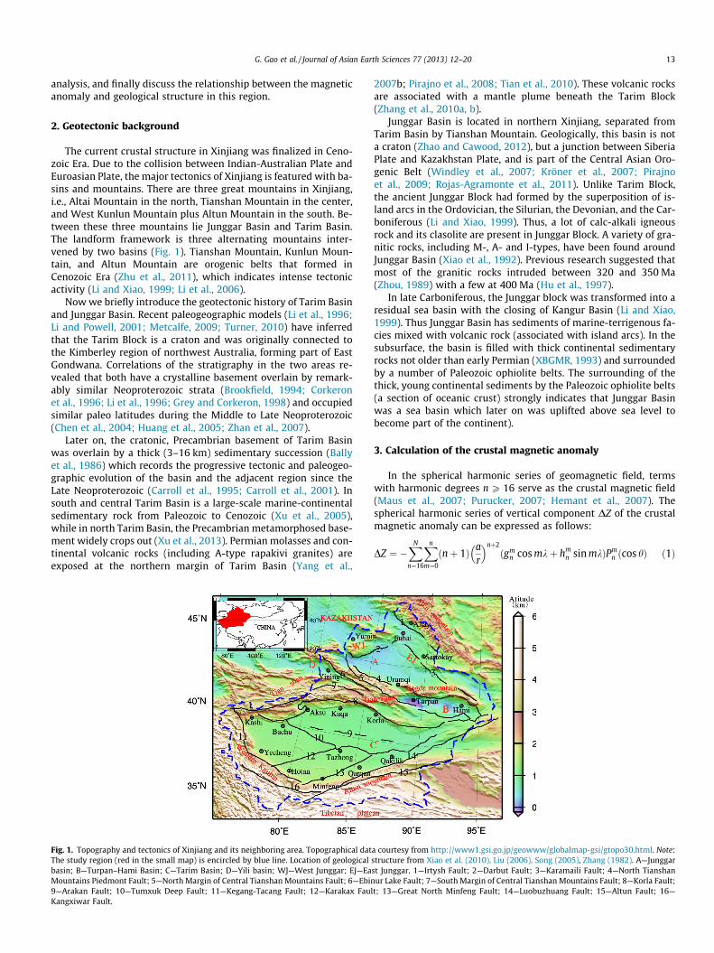
The current crustal structure in Xinjiang was finalized in Ceno-zoic Era. Due to the collision between Indian-Australian Plate andEuroasian Plate, the major tectonics of Xinjiang is featured with ba-sins and mountains. There are three great mountains in Xinjiang,i.e., Altai Mountain in the north, Tianshan Mountain in the center,and West Kunlun Mountain plus Altun Mountain in the south. Be-tween these three mountains lie Junggar Basin and Tarim Basin.The landform framework is three alternating mountains inter-vened by two basins (Fig. 1). Tianshan Mountain, Kunlun Moun-tain, and Altun Mountain are orogenic belts that formed inCenozoic Era (Zhu et al., 2011), which indicates intense tectonicactivity (Li and Xiao, 1999; Li et al., 2006).
Now we briefly introduce the geotectonic history of Tarim Basinand Junggar Basin. Recent paleogeographic models (Li et al., 1996;Li and Powell, 2001; Metcalfe, 2009; Turner, 2010) have inferredthat the Tarim Block is a craton and was originally connected tothe Kimberley region of northwest Australia, forming part of EastGondwana. Correlations of the stratigraphy in the two areas re-vealed that both have a crystalline basement overlain by remark-ably similar Neoproterozoic strata (Brookfield, 1994; Corkeronet al., 1996; Li et al., 1996; Grey and Corkeron, 1998) and occupiedsimilar paleo latitudes during the Middle to Late Neoproterozoic(Chen et al., 2004; Huang et al., 2005; Zhan et al., 2007).
Later on, the cratonic, Precambrian basement of Tarim Basinwas overlain by a thick (3–16 km) sedimentary succession (Ballyet al., 1986) which records the progressive tectonic and paleogeo-graphic evolution of the basin and the adjacent region since theLate Neoproterozoic (Carroll et al., 1995; Carroll et al., 2001). Insouth and central Tarim Basin is a large-scale marine-continentalsedimentary rock from Paleozoic to Cenozoic (Xu et al., 2005),while in north Tarim Basin, the Precambrian metamorphosed base-ment widely crops out (Xu et al., 2013). Permian molasses and con-tinental volcanic rocks (including A-type rapakivi granites) areexposed at the northern margin of Tarim Basin (Yang et al.,
Fig. 1. Topography and tectonics of Xinjiang and its neighboring area. Topographical datThe study region (red in the small map) is encircled by blue line. Location of geologicalbasin; B—Turpan–Hami Basin; C—Tarim Basin; D—Yili basin; WJ—West Junggar; EJ—EaMountains Piedmont Fault; 5—North Margin of Central Tianshan Mountains Fault; 6—Ebin9—Arakan Fault; 10—Tumxuk Deep Fault; 11—Kegang-Tacang Fault; 12—Karakax FaulKangxiwar Fault.
2007b; Pirajno et al., 2008; Tian et al., 2010). These volcanic rocksare associated with a mantle plume beneath the Tarim Block(Zhang et al., 2010a, b).
Junggar Basin is located in northern Xinjiang, separated fromTarim Basin by Tianshan Mountain. Geologically, this basin is nota craton (Zhao and Cawood, 2012), but a junction between SiberiaPlate and Kazakhstan Plate, and is part of the Central Asian Oro-genic Belt (Windley et al., 2007; Kröner et al., 2007; Pirajnoet al., 2009; Rojas-Agramonte et al., 2011). Unlike Tarim Block,the ancient Junggar Block had formed by the superposition of is-land arcs in the Ordovician, the Silurian, the Devonian, and the Car-boniferous (Li and Xiao, 1999). Thus, a lot of calc-alkali igneousrock and its clasolite are present in Junggar Block. A variety of gra-nitic rocks, including M-, A- and I-types, have been found aroundJunggar Basin (Xiao et al., 1992). Previous research suggested thatmost of the granitic rocks intruded between 320 and 350 Ma(Zhou, 1989) with a few at 400 Ma (Hu et al., 1997).
In late Carboniferous, the Junggar block was transformed into aresidual sea basin with the closing of Kangur Basin (Li and Xiao,1999). Thus Junggar Basin has sediments of marine-terrigenous fa-cies mixed with volcanic rock (associated with island arcs). In thesubsurface, the basin is filled with thick continental sedimentaryrocks not older than early Permian (XBGMR, 1993) and surroundedby a number of Paleozoic ophiolite belts. The surrounding of thethick, young continental sediments by the Paleozoic ophiolite belts(a section of oceanic crust) strongly indicates that Junggar Basinwas a sea basin which later on was uplifted above sea level tobecome part of the continent).
3. Calculation of the crustal magnetic anomaly
In the spherical harmonic series of geomagnetic field, termswith harmonic degrees n P 16 serve as the crustal magnetic field(Maus et al., 2007; Purucker, 2007; Hemant et al., 2007). Thespherical harmonic series of vertical component DZ of the crustalmagnetic anomaly can be expressed as follows:
DZ ¼ �XN
n¼16
Xn
m¼0
ðnþ 1Þ ar
� �nþ2ðgm
n cos mkþ hmn sin mkÞPm
n ðcos hÞ ð1Þ
a courtesy from http://www1.gsi.go.jp/geowww/globalmap-gsi/gtopo30.html. Note:structure from Xiao et al. (2010), Liu (2006), Song (2005), Zhang (1982). A—Junggarst Junggar. 1—Irtysh Fault; 2—Darbut Fault; 3—Karamaili Fault; 4—North Tianshanur Lake Fault; 7—South Margin of Central Tianshan Mountains Fault; 8—Korla Fault;
t; 13—Great North Minfeng Fault; 14—Luobuzhuang Fault; 15—Altun Fault; 16—

Fig. 2. Crustal magnetic anomaly from (a) NGDC-720 model and (b) aeromagneticanomaly in Xinjiang, as well as regional faults.
14 G. Gao et al. / Journal of Asian Earth Sciences 77 (2013) 12–20
where k and h are longitude and latitude, respectively, a is the Earthradius (6371.2 km), Pm
n ðcos hÞ is the Schmidt quasi-normalized asso-ciated Legendre function of degree n and orderm, gm
n and hmn are
spherical harmonic coefficients, and N is a truncation level. In thispaper, N is set to degree 720, and the grid is 0.1� � 0.1�. Substitutingthe NGDC-720-V3 spherical harmonic coefficients into Eq. (1) yieldsthe crustal magnetic anomaly on the earth surface for Xinjiang. Thespatial distribution is shown in Fig. 2a.
Based on the 1:5,000,000 aeromagnetic anomaly map of Chinaand its neighboring seas compiled by China Aero Geophysical Sur-vey and Remote Sensing Center for Land and Resources in 2004, wedownward-continued the data to the Earth surface, to obtain theaeromagnetic anomaly distribution in Xinjiang. For the conve-nience of comparing the modeled magnetic anomaly with theaeromagnetic anomaly, we plot the latter in Fig. 2b.
4. Relation between the crustal magnetic anomalyand geological structure
4.1. Basic feature of the crustal magnetic anomaly
As shown in Fig. 2a, the crustal magnetic anomaly distributionis complex, i.e., having positive anomaly zones, negative anomalyzones, dramatic gradient zones, and banded anomaly zones withalternating positive and negative values. Anomaly intensity variessignificantly, from �307 to 465 nT. Magnetic anomaly diverges inthe west of Xinjiang and converges in the east. It extends primarilyin the north–west direction in north Xinjiang, but in the east–westor north–east direction in south Xinjiang. The two groups in thewest merge into approximately the east–west direction in the east,forming a flared planar shape. In terms of polarity, the magneticanomaly divides into two positive zones and one negative zone,demarcated roughly by north Margin of Central Tianshan
Mountain Fault and Arakan Fault (Fig. 2a). One positive anomalyzone is distributed in South Tarim Basin, and the other is fromJunggar Basin to Turpan–Hami Basin. The negative anomaly zoneis distributed in the west and middle of Tianshan Mountain andNorth Tarim Basin.
The south Tarim positive magnetic anomaly zone is distributedin Tarim Basin from 40�N–41�N line southward to the Karghilik–Hotan–Qakilik line, with an extension direction approximately inthe east–west or north–east. This zone is broad in the west andnarrow in the east, like a triangle. Its northern boundary is ArakanFault which divides Tarim Basin magnetic anomaly into south andnorth parts. The north part is negative while the south part is po-sitive. The southwest boundary is Kegang-Tacang Fault which sep-arates the strong positive magnetic anomaly in south Tarim Basinfrom the weak magnetic anomaly in west Kunlun Mountain. Thesoutheast boundary is Great North Minfeng Fault which separatesthe positive anomaly in south Tarim Basin from the weak anomalyin Altun Mountain. This positive anomaly zone has small negativeanomaly appearing in Guma, Hotan and Tazhong–Qakilik.
The other positive anomaly zone, namely, the Junggar–Turpan–Hami positive anomaly zone, lies on the north side of North Tian-shan Mountain, comprising magnetic anomaly of different patterns(Fig. 2a). From central Junggar Basin to its northwest margin is oneannular positive anomaly with anomaly intensity of 100–200 nT.From the south margin of Junggar Basin to Turpan–Hami Basin isa positive anomaly band approximately in the east–west directionwith intensity at 80–310 nT. In Yumin–Fuhai–Ertan is anotherannular positive anomaly. Altai Mountain has a negative magneticanomaly, with the strongest anomaly focus being 310 nT at(92.2�E, 42.2�N). Please note that the positive magnetic anomaliesin Junggar Basin and Turpan–Hami Basin are separated by the neg-ative magnetic anomaly along Bogda Mountain.
The negative magnetic anomaly zone is distributed widely inthe west and center of Tianshan Mountain and in the north of Tar-im Basin, extending in the north–west direction as a whole. Thestrongest negative anomaly focus is �307 nT at (80.3�E, 40.6�N).
4.2. Crustal magnetic anomaly and aeromagnetic anomaly
Comparison of the aeromagnetic anomaly distribution (Fig. 2b)with the crustal magnetic anomalies calculated from NGDC-720-V3 model (Fig. 2a) reveals only a minor discrepancy and a consis-tent trend generally. The crustal magnetic anomaly calculated fromthe model presents clearer magnetic anomaly bands and betterrelationship between the magnetic anomaly and the faults. In con-trast, the aeromagnetic survey cannot be extrapolated to the alti-tude of satellite due to the limitation from the continuationtechnique. Hence, it provides a limited help for studying deepbasement distribution. Fortunately, a high-order geomagnetic fieldmodel constructed using satellite, ground, oceanic, and aeromag-netic survey data can help us obtain magnetic anomalies in allhorizons from the ground surface to the satellite altitude.
4.3. Decay characteristics of the crustal magnetic anomaly
Analyzing the distribution of magnetic anomaly at differentaltitudes above ground can help understand the decay characteris-tics of the anomaly. We calculate the distribution of magneticanomaly on four horizons at altitude 20 km, 100 km, 200 km and400 km, as shown in Fig. 3. The result indicates that local strongmagnetic anomalies decay rapidly with altitude, i.e., high-fre-quency components diminish and the distribution patterns be-come simpler with the increase of altitude.
At altitude 400 km, the magnetic anomaly pattern is simple,with a low intensity. Except a negative anomaly over Yili Basinand Altai Mountain in north Xinjiang, other areas have positive

Fig. 3. Distribution of the crustal magnetic anomaly at altitude (a) 20 km; (b) 100 km; (c) 200 km; and (d) 400 km.
G. Gao et al. / Journal of Asian Earth Sciences 77 (2013) 12–20 15
anomaly. The strongest positive anomaly is located in Tarim Basin,with a focus (81.3�E, 38.2�N) of 8 nT; this anomaly covers thewhole Tarim Basin, extending to Turpan–Hami Basin and JunggarBasin. Because high-frequency components decay, the majoranomaly at altitude 400 km come from long wavelength of thecrust, representing macroscale crustal basement. At altitude200 km, a negative anomaly zone begins to appear in north TarimBasin and Tianshan Mountain, extending to Urumqi. At altitude100 km, small positive anomaly emerges in the central and southof Tarim Basin and spanning Junggar–Turpan–Hami Basin, whilethe contour of Yili wedge-shaped positive magnetic field beginsto appear. At altitude 20 km, the outline of the magnetic anomalybecomes visible. It is worth noting that the negative magneticanomaly over Bogda Mountains only appears at altitude 20 km.
4.4. Relation between the magnetic anomaly and geological structure
Comparing Fig. 1 with 2, we find that the spatial distribution ofmagnetic anomaly in Xinjiang basically agrees with the geologicalstructure, well reflecting the tectonic feature, i.e., alternatingmountain ranges intervened by basins. In general, except northTarim Basin, there are distinct boundaries between the basin’sstrong positive anomaly and negative magnetic anomaly over themountains. The southwest and southeast boundaries of Tarim Ba-sin are bordered by weak magnetic anomalies over West KunlunMountain and Altun Mountain, respectively. Margin of Junggar Ba-sin is mountain-based negative anomaly over east and west Jung-gar Mountain and Tianshan Mountain. The quasi-triangularnegative magnetic anomaly is intervened by the positive magneticanomaly over Junggar Basin. Negative magnetic anomaly overTianshan Mountain is intervened by the positive magnetic anom-aly over Turpan–Hami Basin and Yili Basin.
Crustal magnetic anomaly is caused by magnetic bodies in thecrust, such that the spatial distribution of the magnetic anomalyreflects the distribution of magnetic bodies in the consolidatedcrust. The magnetic anomaly distribution from the ground to the
satellite altitude indicates that the entire Xinjiang is a sophisti-cated massif composed by magnetic bodies with different sizes,different directions, and different depths. The deepest magneticbody is a positive magnetic basement covering Tarim Basin andJunggar–Turpan–Hami Basin. This basement is overlaid by the neg-ative magnetic massif covering north Tarim Basin and TianshanMountains. Yili Basin is a wedge-shaped positive magnetic massifbordered by Ebinur Lake Fault and south Margin of Central Tian-shan Mountains Fault. Tarim Basin may be seen as a double-layerstructure (Li and Xiao, 1999). The lower layer is basin wide,whereas the upper basement is divided into South Tarim positivemagnetic massif and North Tarim negative magnetic massif. Thesouth Tarim magnetic massif is roughly surrounded by ArakanFault, Kegang–Tacang Fault and Great North Minfeng Fault, result-ing in a triangle wide in the west and narrow in the east. The Jung-gar–Turpan–Hami Basin basement is bordered by Darbut Fault,Karamaili Fault and north Margin of Central Tianshan MountainsFault, presenting a fan shape. The Bogda Mountain negativemagnetic anomaly splits Junggar–Turpan–Hami Basin positiveanomaly.
The distribution of intensity of the crustal magnetic anomaly inXinjiang is well corresponding with the faults. This is because onthe two sides of a fault are mountain and basin, which have nega-tive and positive magnetic anomalies, respectively. Thus, the faultshould present a weak intensity in magnetic anomaly. Magneticanomaly on both sides of Arakan Fault has very different features,with negative anomaly on the north side while positive anomalyon the south side. This fact leads to a conclusion that the fault di-vides the whole Tarim Basin into two tectonic parts: to the northare non-magnetic or weak magnetic rocks, while to the south arepartially magnetic cover and magnetic crystalline basement. Tum-xuk Deep Fault divides the south Tarim positive anomaly zone intoone part approximately in east–west strike and the other part innorth–east strike. The distinct anomalous feature exists in mag-netic anomaly on both sides of the faults. Such good correlation be-tween magnetic anomaly and fault zone indicates that major faults

16 G. Gao et al. / Journal of Asian Earth Sciences 77 (2013) 12–20
in Xinjiang acts as the boundary among geologic bodies of differentnatures.
Magnetic anomaly distribution in south Tianshan Mountain isdistinctly different from that in north Tianshan Mountain. SouthTianshan Mountain and north Tarim Basin have negative magneticanomaly with blurred mountain-basin boundary. Studies on deepstructure of lithosphere in Tianshan Mountain and north margin ofTarim Basin (Zhao et al., 2004; Xu et al., 2001) revealed that duringsubduction to the South Tianshan Mountain orogenic belt, the sub-stances in north margin of Tarim Basin were carried to the orogenicbelt and reformed into the crust of south Tianshan Mountain. Thecurrent crust of south Tianshan Mountain was part of Tarim Block.South Tianshan Mountain has no clear mountain root, because themagnetic anomaly in south Tianshan Mountain and north TarimBasin are both negative. This is consistent with the conclusion fromseismic wave inversion (Tang et al., 2011; Li et al., 2007). The north ofCentral Tianshan Mountain Fault has strong positive magneticanomaly, whereas to the south of the Fault is negative magneticanomaly. When underthrusting toward Tianshan Mountain,magnetic substance of Junggar Basin may be blocked by CentralTianshan Mountain Fault, such that north Tianshan Mountain andJunggar Basin have the same positive magnetic anomaly. The distri-bution feature of the magnetic anomaly is consistent with differentmagnetic/density structure (Zhao et al., 2004), and different velocitystructure (Xiong et al., 2011; Lei et al., 2013) between northTianshan Mountain and south Tianshan Mountain.
Now we discuss the correlation between the magnetic anomalyon the ground surface (Fig. 2a) and the mafic dykes in Tarim Basinas shown in Fig. 4 (Zhang, 1982; Li et al., 2009; Zhu et al., 2011). Geo-logically, in north Tarim Basin is a Proterozoic weakly or nonmag-netic basement lithofacies, which is very well corresponding to thenegative magnetic anomaly in the north Tarim Basin in Fig. 2a. Thecentral Tarim Basin is dominated by Paleoproterozoic magneticgranite, also very well corresponding to a clear positive magneticanomaly in the central Tarim Basin. As shown in Fig. 2a, south TarimBasin is characterized with a series of NE belts with alternating po-sitive magnetic anomaly and negative anomaly. On the other hand,in Fig. 4, in the south Tarim Basin is the NE Hotan fold system com-posed of four magnetic basement lithofacies belts separated by threeweakly magnetic basement lithofacies belts. Overall, the maganeticanomaly in Tarim Basin is well corresponding to the mafic dykes.
5. Curie isothermal surface
Crustal magnetic anomaly is a combination of the effects fromshallow and deep crustal magnetic sources. If the wavelength isclose to each other, magnetic anomaly sources at different depthswill mix and lead to aberration in deep magnetic body anomaly,
Fig. 4. Basement lithofacies beneath Tarim Basin, modified from Zhang (1982).
decreasing the accuracy of Curie surface inversion. For this reason,the impact of shallow magnetic bodies has to be filtered away frommagnetic anomaly. Methods of suppressing the effect of shallowmagnetic source include low-pass filter (Gasparini et al., 1981), up-ward continuation (Guan, 2005), multiscale 2D discrete wavelettransform analysis (Maurizio and Tatiana, 1998; Hou and Yang,2011), and calculation of magnetic anomalies over long-to-med-ium wavelength bands using crustal magnetic field model (Kanget al., 2011; Kumar and Alice, 2009; Mita et al., 2009). In this paper,we select NGDC-720-V3 model of suitable order to eliminate influ-ence from shallow magnetic bodies.
According to Lowes-Mauersberger energy spectrum algorithm(Lowes, 1974), the geomagnetic field energy spectrum is
WðnÞ ¼ ðnþ 1ÞXn
m¼0
½ðgmn Þ
2 þ ðhmn Þ
2� ð2Þ
Variation of crustal magnetic field energy spectra in the NGDC-720-V3 model with harmonic orders, as shown in Fig. 5, indicatesthat the crustal magnetic energy spectra is not homogeneous. En-ergy spectra at order 16–60 increases with the increase of har-monic order, called long wavelength zone. Energy spectra atorder 61–220 is relatively stable, called medium wavelength zone.Energy spectra at order 221–720 gradually decreases, called shortwavelength zone. Magnetic anomaly in long to medium wave-lengths primarily reflects magnetic feature of deep and intermedi-ate crustal lithosphere, and magnetic anomaly in short wavelengthis primarily generated by shallow magnetic bodies (Kang et al.,2011). Fig. 6a and b are the modeled magnetic anomaly with order16–220 and that with order 221–720. The latter is dominated bylocal feature reflecting the shallow magnetic sources. Therefore,the magnetic anomaly at order 16–220 is chosen and the powerspectrum method (Spector and Grant, 1970) is employed in thispaper to calculate Curie surface beneath Xinjiang.
The calculation of Curie surface is conducted in the wavenum-ber domain. Assuming that a magnetic-source body extends infi-nitely in the horizontal direction and its depth is much smallercompared with the horizontal scale, depth to the top of the mag-netic-source body, Zt, and depth to the center point Z0 are (Li,2003; Li et al., 2009 )
Zt ¼ln½AðjkjÞ� � ln D
�jkj ð3Þ
Fig. 5. Energy spectra of the NGDC-720-V3 model with the harmonic order.

Fig. 6. The crustal magnetic anomaly at different wavelength bands: (a) n = 16–220; and (b) n = 221–720.
G. Gao et al. / Journal of Asian Earth Sciences 77 (2013) 12–20 17
Z0 ¼ln½AðjkjÞ=jkj� � ln E
�jkj ; ð4Þ
respectively, where A(|k|) is the amplitude spectrum of magneticanomaly, k is wavenumber, and D and E are constants. The lowerboundary of the magnetic body, i.e., the depth of the Curie surface,Zb, is
Zb ¼ 2Z0 � Zt ð5Þ
In the procedure of calculation, we firstly divide the study re-gion into a grid of 37 � 23 squares. Each square has a size of125 km � 125 km, and two neighboring squares have an overlapof 50%. Secondly, we calculate the amplitude spectrum of magnetic
Fig. 7. Depth of the Curie surface in Xinjiang: (a) from
anomaly and the ratio of amplitude spectrum to wavenumber foreach square. Thirdly, we select the amplitude spectra in frequencyinterval 0.053–0.1 rad/km (the high-to-medium wavenumber do-main) to fit Zt via (3), and then select the ratio of amplitude spec-trum to wavenumber in frequency interval 0.001–0.05 rad/km (thelow wavenumber domain) to fit Z0 via (4). The depth to Curie iso-thermal surface is got via (5).
After getting the depths to Curie surface for all squares, we use aminimum curvature method to interpolate the depths of Curie sur-face for the whole study region (Fig. 7a). The histograms in Fig. 7agive a statistical distribution of the depths of Curie surface. Theinversion result shows that the Curie surface in Xinjiang varies sig-nificantly in depth, ranging from 30 to 50 km with an average of39 km. This result agrees well with the Curie surface depths fromaeromagnetic survey (Li and Xu, 1999; Zhang, 2003; Wang et al.,1996).
The most distinct feature of the Curie surface in Xinjiang is thatbeneath mountains is a shallow Curie surface while beneath basinsis a deep Curie surface. This indicates that the basins are cold, rigid,and stable, while the mountains are orogenically active. In thesouth and east of Tarim Basin and Kuqa, in Yili Basin, in the southof Turpan–Hami Basin, in Turpan area, and in the central and westof Junggar Basin, Curie surface is as deep as 46 km. In West KunlunMountain, Altun Mountain, Tianshan Mountain, and Altai Moun-tain, Curie surface is generally shallow with depth less than39 km. The Curie surface in Qarqan is only 30 km deep, being theshallowest in Xinjiang. In mountain-basin transitional zones, espe-cially the transition zone between West Kunlun Mountain, SouthTianshan Mountain and Tarim Basin, on the basin side is a deepCurie surface, while on the mountain side is a shallow Curie sur-face. In Junggar Basin, the Gurbantunggut Desert has a shallowCurie surface with depth at only 38 km,indicating that JunggarBasin is probably a relatively hot basin.
Comparison of the Curie surface depth with the faults shows agood relationship between them. Across major abyssal faults, Curiesurface depth varies significantly. For example, Curie surface isdeep on the south side of Arakan Fault but shallow on the northside. Curie surface is deep on the west side of North Minfeng Faultbut shallow on the east side. Curie surface is deep on the north sideof South Tianshan Mountain Piedmont Fault but shallow on thesouth side.
There exists a certain correlation between the crustal magneticanomaly and the Bouguer gravity anomaly in Xinjiang. The strikingfeature of gravity anomaly (Peng, 2005) is similar to that of mag-netic anomaly, i.e., both are parallel to major mountains. Gravity
the model; and (b) from aeromagnetic anomaly.

Fig. 8. Depth of the Moho in Xinjiang.
Table 1Value of terrestrial heat flow in Xinjiang (Wang et al., 1996, 2000).
Region Terrestrial heat flow (mW/m2)
Tarim Basin 42–56Junggar Basin 41–61Tianshan Mountain 70Turpan–Hami Basin 44Qakilik–Qarqan region 73
18 G. Gao et al. / Journal of Asian Earth Sciences 77 (2013) 12–20
anomaly appears low over mountains but high over basins. Mag-netic anomaly is negative over mountains but positive over basins.The relationship between magnetic anomaly and gravity anomalyis indirectly reflected in Curie surface and Moho interface. Asshown in Fig. 8, the Moho interface (Lin and Liu, 1995) and the Cur-ie surface present an anti-mirror correspondence in TianshanMountain and its south. In Tianshan Mountain, Altun Mountainand West Kunlun Mountain, the Moho is deep, and the Curie sur-face there is shallow. In Tarim Basin, the situation is in reverse, alsopresenting an anti-mirror correspondence.
The depths of the Curie surface and the Moho are basically thesame in the central Junggar Basin. Therefore, in this region, theMoho could be considered as a magnetic boundary. Above is themagnetic lower crust, while below is the nonmagnetic upper man-tle. In the east and west Junggar Basin and Gurbantunggut Desert,the depth of the Curie surface is less than that of the Moho.
The Curie surface has a certain correlation with the terrestrialheat flow in Xinjiang. Table 1 lists terrestrial heat flows in someareas of Xinjiang. From Fig. 5 and Table 1, Curie surface is relativelyshallow in areas with high terrestrial heat flow, but deep in areaswith low terrestrial heat flow. For example, in Qakilik–Qarqan re-gion and Tianshan Mountains, terrestrial heat flow value is highand Curie surface is shallow. In Junggar Basin, Tarim Basin and Tur-pan–Hami Basin, terrestrial heat flow value is low and Curie sur-face is deep. The fact of a high heat flow value in the center buta low flow value in the margins of Tarim Basin (Wang et al.,1996) is well corresponding to a shallow Curie surface in the centerbut a deep surface in the margins of the basin. Junggar Basin is fea-tured with a low terrestrial heat flow in the center and a high valuein the margins (Wang et al., 2000), corresponding to a deep Curiesurface in the center and a shallow surface in the margins of thebasin. The difference between Tarim Basin and Junggar Basin inCurie surface implies different thermal structures and thermal evo-lution histories.
6. Discussion
To validate the Curie isotherm surface inverted for from theNGDC-720-V3 Model, we use aeromagnetic anomaly in Fig. 2b to
compute the Curie surface. Firstly, we continuate the observedaeromagnetic anomaly upward to 20 km over the ground surface,by multiplying a decaying factor in the frequency domain (Liet al., 2009). This step aims to remove the effect from the shallowmagnetic bodies (Hu et al., 2006). Secondly, the aeromagneticanomaly is used to compute the Curie surface, with the same pro-cedure as in Section 5. The Curie surfaces from the NGDC-720-V3model and the aeromagnetic anmoly are plotted in Fig. 7a and b,respectively. Comparing Fig. 7a with b, we find that two ap-proaches leads to roughly the same result. Nonetheless, Fig. 7a ap-pears to be more consistent with the geological structure in Fig. 1.
The magnetic anomaly is negative in north Tarim Basin andnortheast Junggar Basin. The reason why north Tarim Basin has anegative magnetic anomaly is due to a Proterozoic weakly or non-magnetic basement lithofacies; see Fig. 4. Unfortunately, the reasonwhy northeast Junggar Basin has a negative anomaly is difficult toexplain currently due to the lack of geological evidence there.
The average Curie surface depth beneath north Tarim Basin isapproximately 49 km, while that beneath northeast Junggar Basinis approximately 39 km. According to previous study of the geo-thermal field (Liu et al., 2003; Hu et al., 2001), the lithosphere innorth Tarim Basin is cold, with a low terrestrial heat flow(45 mW/m2), whereas the terrestrial heat flow in northeast Jung-gar Basin is at 53 mW/m2. The reason why the two basins have dif-ferent Curie depths is likely due to different terrestrial heat flows.
7. Conclusions
(1) The distribution of crustal magnetic anomaly in Xinjiangagrees well with the geological structure, reflecting the tec-tonic framework in Xinjiang, i.e., alternating mountainsintervened by basins. For instance, west Kunlun Mountainand Altun Mountain have negative magnetic anomaly, inter-vened by strong positive anomaly in South Tarim Basin. Thedistribution of positive and negative magnetic anomaly isconsistent with the striking of major faults. The magneticanomaly on the ground surface presents good correspon-dence with the mafic dykes in Tarim Basin.
(2) The decay of the magnetic anomaly with altitude from theground to altitude 400 km shows that Xinjiang is a sophisti-cated massif composed of magnetic massifs of different sizesin different directions at different depths. The deepest mag-netic body is a positive magnetic basement covering TarimBasin and Junggar–Turpan–Hami Basin. This basement isoverlaid by negative magnetic massifs in North Tarim Basinand Tianshan Mountain. Tarim Basin may be a double layerstructure, with the lower layer being basin-wide.
(3) The depth of Curie isothermal surface reveals a distinct fea-ture, i.e., a shallow surface in mountains but a deep surfacein basins. This indicates that the basins are cold, rigid, andstable, while the mountains are orogenically active. Acrossthe major abyssal faults, Curie surface varies significantly.The Moho interface and the Curie surface present an anti-mirror correspondence in Tianshan Mountain and its south.,i.e., the Curie surface is shallow where the Moho interface isdeep, and vice versa. Curie surface is shallow in areas withhigh terrestrial heat flow, and deep in regions with low ter-restrial heat flow.
Acknowledgements
This study was sponsored by the National Science Foundation ofChina under Grant 41264003, as well as the Foundation of Provin-cial Education Department of Yunnan under contract 2012Y488.
G. Gao et al. / Journal of Asian Earth Sciences 77 (2013) 12–20 19
References
Achache, J., Abtout, A., LeMouel, J.L., 1987. The downward continuation of Magsatcrustal anomaly field over Southeast Asia. Journal of Geophysical Research-Atmospheres 92, 11584–11596.
Arkani, H.J., Zhao, S.K., Strangway, D.W., 1988. Geophysical interpretation of themagnetic anomalies of China derived from MAGSAT data. Geophysical JournalInternational 95, 347–359.
Bally, A.W., Chou, I.M., Clayton, R., Eugster, H.P., Kidwell, S., Meckel, L.D., Ryder, R.T.,Watts, A.B., Wilson, A.A., 1986. Notes on sedimentary basins in China: report ofthe American sedimentary basins delegation to the People’s Republic of China.US Geological Survey, Open File Report 86–327, 108.
Brookfield, M.E., 1994. Problems in applying preservation facies and sequencemodels to Sinian (Neoproterozoic) glacial sequences in Australia and Asia.Precambrian Research 70, 143–147.
Carroll, A.R., Graham, S.A., Hendrix, M.S., Ying, D., Zhou, D., 1995. Late Paleozoictectonic amalgamation of northwestern China: sedimentary record of thenorthern Tarim, northwestern Turpan, and southern Junggar Basins. GeologicalSociety of America Bulletin 107, 571–594.
Carroll, A.R., Graham, S.A., Chang, E.Z., McKnight, C., 2001. Sinian through Permiantectonostratigraphic evolution of the northwestern Tarim basin, China. In:Hendrix, M.S., Davis, G.A. (Eds.), Paleozoic and Mesozoic Tectonic Evolution ofCentral Asia: From Continental Assembly to Intracontinental Deformation, vol.194. Geological Society of America, Memoir, pp. 47–69.
Chen, Y., Xu, B., Zhan, S., Li, Y., 2004. First mid-Neoproterozoic paleomagneticresults from the Tarim Basin (NW China) and their geodynamic implications.Precambrian Research 133, 271–281.
Corkeron, M., Grey, J., Li, Z.X., Powell, C.M., 1996. Neoproterozoic glacial episodes inthe Kimberley region, northwestern Australia. Abstracts of the GeologicalSociety of Australia 41, 97.
Deng, Z.Q., Wang, X.G., Xie, D.S., 1992. Characteristics of geophysical field, Xinjiang.Xinjiang Geology 10 (3), 233–243 (in Chinese with English abstract).
Gasparini, P., Mantovani, M.S.M., Shukowsky, W., 1981. On the posibility of a directautomatic inversion of the D.C. geoelectric data, In: Cassinis, R. (Eds.), TheSolution of the Inverse Problem in Geophysical Interpetation. Plenum Press, pp.112–124.
Grey, K., Corkeron, M., 1998. Late Neoproterozoic stromatolites in glacigenicsuccessions of the Kimberley region. Western Australia: evidence for a youngerMarinoan glaciation. Precambrian Research 92, 65–87.
Guan, Z.N., 2005. Geomagnetic Field and Magnetic Expioration. GeologicalPublishing House (in Chinese), Beijing.
Hemant, K., Maus, M., 2005. Why no anomaly is visible over most of the continent-ocean boundary in the global crustal magnetic field. Physics of the Earth andPlanetary Interiors 149, 321–333.
Hemant, K., Thébault, E., Mandea, M., 2007. Magnetic anomaly map of the world:merging satellite, airborne, marine and ground-based magnetic data sets. Earthand Planetary Science Letters 260, 56–71.
Hou, Z.Z., Yang, W.C., 2011. Multi-scale inversion of density structure from gravityanomalies in Tarim Basin. Science in China Series D-Earth Sciences 54, 399–409.
Hu, A.Q., Wang, Z.G., Tu, G.Z., 1997. Geological evolution and diagenic andmetallogenetic regularity in Northern Xinjiang. Science Press, Beijing, Beijing,pp. 105 (in Chinese).
Hu, S.B., He, L.J., Wang, J.Y., 2001. Compilation of heat flow data in the Chinacontinental area (3rd ed.). Chinese Journal of Geophysics 44 (5), 611–626.
Hu, X.Z., Xu, M.J., Xie, X.A., Wang, L.S., Zhang, Q.L., Liu, S.W., Xie, G.A., Feng, C.G.,2006. A characteristic analysis of aeromagnetic anomalies and Curie pointisotherms in Northeast China. Chinese Journal of Geophysics 49 (6), 1674–1681.
Huang, B., Xu, B., Zhang, C., Li, Y., Zhu, R., 2005. Paleomagnetism of the Baiyisivolcanic rocks (ca. 740 Ma) of Tarim, Northwest China: a continental fragmentof Neoproterozoic Western Australia? Precambrian Research 142, 83–92.
Kang, G.F., Gao, G.M., Bai, C.H., Wang, J., Shao, D., 2010. Distribution of the magneticanomaly for the CHAMP satellite in China and adjacent areas. Chinese Journal ofGeophysics 53 (4), 895–903.
Kang, G.F., Gao, G.M., Bai, C.H., Shao, D., Feng, L.L., 2011. Characteristics of thecrustal magnetic anomaly and regional tectonics in the Qinghai-Tibet Plateauand the adjacent areas. Science in China Series D-Earth Sciences 6, 1028–1036.
Kröner, A., Windley, B.F., Badarch, G., Tomurtogoo, O., Hegner, E., Jahn, B.M.,Gruschka, S., Khain, E.V., Demoux, A., Winjgate, M.T.D., 2007. Accretionarygrowth and crustformation in the central Asian Orogenic Belt and comparisonwith the Arabian–Nubian shield. Geological Society of America, Memoir 200,181–209.
Kumar, H., Alice, M., 2009. Magnetic field modelling and interpretation of theHimalayan–Tibetan Plateau and adjoining north Indian Plains. Tectonophysics487, 87–99.
Lei, X.Q., Chen, Y.P., Zhao, C.B., Zhao, J.M., 2013. Three-dimensional thermo-mechanical modeling of the Cenozoic uplift of Tianshan moutains driventectonically by the Pamir and Tarim. Journal of Asian Earth Sciences 62, 797–811.
Li, C.F., 2003. Rescaled-range and power spectrum analyses on well-logging data.Geophysical Journal International 153, 201–212.
Li, Z.X., Powell, C.Mc.A., 2001. An outline of the paleogeographic evolution of theAustralasian region since the beginning of the Neoproterozoic. Earth-ScienceReviews 53, 237–277.
Li, J.Y., Xiao, X.C., 1999. Brief reviews on some issues of framework and tectonicevolution of Xinjiang crust, NW China. Scientia Geologica Sinica 34, 405–419.
Li, Q.C., Xu, B.R., 1999. The characteristic and geological meaning of Curie isothermicsurface under the Tarim basin. Oil Geophysical Prospecting 34, 590–594 (inChinese with English abstract).
Li, Z.X., Zhang, L., Powell, C.Mc.A., 1996. Positions of the East Asian cratons in theNeoproterozoic supercontinent Rodinia. Australian Journal of Earth Sciences 43,593–604.
Li, J.Y., He, G.Q., Xu, X., Li, H.Q., Sun, G.H., Yang, T.N., Gao, L.M., Zhu, Z.X., 2006.Crustal tectonic frame work of northern Xinjiang and adjacent regions and itsformation. Acta Geologica Sinica 80, 148–168.
Li, Y., Liu, Q.Y., Chen, J.H., Li, S.C., Guo, J., Lai, Y.G., 2007. Crust and upper mantleshear velocity structure beneath Tian Shan. Science in China Series D-EarthSciences 37, 344–352.
Li, C.F., Chen, B., Zhou, Z.Y., 2009. Deep crustal structures of eastern China andadjacent seas revealed by magnetic data. Science in China Series D-EarthSciences 52, 984–993.
Lin, G.L., Liu, C.Y., 1995. Basic characteristics of deep-seated tectonics in Xinjiang.Xinjiang Geology 13, 56–66 (in Chinese with English abstract).
Liu, X., 2006. Problems of crustal tectonics and evolution in Xinjiang, NorthwestChina. Earth Science Fronotiers 13, 111–117.
Liu, S.W., Wang, L.S., Li, C., Li, H., Han, Y.B., Jia, C.Z., Wei, G.Q., 2003. The northernmargin of the Tarim Basin lithospheric thermo-rheological structure andGeodynamic significance. Science in China Series D-Earth Sciences 33, 852–863.
Lowes, F.J., 1974. Spatial power spectrum of the main geomagnetic field andextrapolation to the core. Geophysical Journal of the Royal Astronomical Society36, 717–730.
Lu, X.B., Yang, L., 1996. Deep-seated lithospheric structrue of Tarim Basin andneighboring area of Xinjiang. Xinjiang Geology 14, 289–296 (in Chinese withEnglish abstract).
Maurizio, F., Tatiana, Q., 1998. Wavelet analysis for the regional residual andlocal separation of potential field anomalies. Geophysical Prospecting 46,507–525.
Maus, S., Sazonova, T., Hemant, K., Fairhead, J.D., Dhananjay, R., 2007. Nationalgeophysical data centers candidate for the world digital magnetic anomalymap. Geochemistry, Geophysics, Geosystems 8, Q06017.
Metcalfe, I., 2009. Late Palaeozoic and Mesozoic tectonic and palaeogeographicalevolution of SE Asia. In: Buffetaut, E., Cuny, G., Le Loeuff, J., Suteethorn, V. (Eds.).Late Palaeozoic and Mesozoic Ecosystems in SE Asia, vol. 315. The GeologicalSociety, London, pp. 7–23 (special publications).
Mita, R., Anand, S.P., Hemant, K., Purucker, M.E., 2009. Curie isotherm map of Indiansubcontinent from satellite and aeromagnetic data. Earth and Planetary ScienceLetters 281, 147–158.
Peng, C., 2005. Bouguer anomalies and cruatal density structure in western China.Acta Geoscientica Sinica 26, 417–422 (in Chinese with English abstract).
Pirajno, F., Mao, J.W., Zhang, Z.C., Zhang, Z.H., Chai, F.M., 2008. The association ofmafic–ultramafic intrusions and A-type magmatism in the Tian Shan and Altayorogens, NW China: implications for geodynamic evolution and potential forthe discovery of new ore deposits. Journal of Asian Earth Sciences 32, 165–183.
Pirajno, F., Erns, R.E., Borisenko, A.S., Fedoseev, G., Naumov, E.A., 2009. Intraplatemagmatism in Central Asia and China and associated metallogeny. Ore GeologyReviews 35 (2), 114–136.
Purucker, M.E., 2007. Magnetic anomaly map of the World. EOS Transactions –American Geophysical Union 88, 263–274.
Rojas-Agramonte, Y., Kröner, A., Demoux, A., Xia, X., Wang, W., Donskaya, T., Liu, D.,Sun, M., 2011. Detrital and xenocrystic zircon ages from Neoproterozoic toPalaeozoic arc terranes of Mongolia: significance for the origin of crustalfragments in the Central Asian Orogenic Belt. Gondwana Research 19, 751–763.
Song, H.P., 2005. The relation between characteristics of deep and big faults andearthquakes in Xinjiang. Inland Earthquake 19, 193–202 (in Chinese withEnglish abstract).
Spector, A., Grant, F.S., 1970. Statistical models for interpreting aeromagnetic data.Geophysics 35, 293–302.
Tang, X.Y., Fan, W.Y., Feng, Y.G., Tang, Y.C., Chen, Y.S., Zhu, L.X., 2011. Phase velocitytomography of Rayleigh wave in Xinjiang from ambient noise. Chinese Journalof Geophysics 54, 2042–2049.
Tian, W., Campbell, I.H., Allen, C.M., Guan, P., Pan, W.Q., Chen, M.M., Yu, H.J., Zhu,W.P., 2010. The Tarim picrite–basalt–rhyolite suite, a Permian flood basalt fromnorthwest China with constrasting rhyolites produced by fractionalcrystallization and anatexis. Contributions to Mineralogy and Petrology 160,407–425.
Turner, S.A., 2010. Sedimentary record of Late Neoproterozoic rifting in the NWTarim Basin, China. Precambrian Research 181, 85–96.
Wang, L.S., Li, C., Yang, C., 1996. The lithospheric thermal structure beneath TarimBasin, western China. Chinese Journal of Geophysics 6, 794–803.
Wang, S.J., Hu, S.B., Wang, Y., 2000. The characteristics of heat flow and geothermalfield in Junggar Basin. Chinese Journal of Geophysics 43, 771–779.
Windley, B.F., Alexeiev, D., Xiao, W.J., Kröner, A., Badarch, G., 2007. Tectonic modelsfor accretion of the Central Asian Orogenic Belt. Journal of the GeologicalSociety, London 64, 31–47.
XBGMR (Xinjiang Bureau of Geology and Mineral Resources), 1993. RegionalGeology of Xinjiang Uygur Autonomous Region, Geological Memoirs, Series 1,No. 32, Ministry of Geology and Mineral Resources, China. Geological PublishingHouse, Beijing, p. 846 (in Chinese).
Xiao, X.C., Tang, Y.Q., Feng, Y.M., Zhu, B.Q., Li, J.Y., Zhou, M., 1992. Tectonics inNorthern Xinjiang and its neighboring Areas. Geological Publishing House,Beijing, pp. 126 (in Chinese).

20 G. Gao et al. / Journal of Asian Earth Sciences 77 (2013) 12–20
Xiao, X.C., He, G.Q., Xu, X., Li, J.Y., Hao, J., Cheng, S.D., Deng, Z.Q., Li, Y.A., 2010.Crustal Tectonic Framework and Geological Evolution of Xinjiang UygurAutonomous Region of China. Seismological Press, Beijing, pp. 56–60 (inChinese)
Xiong, S.Q., 2009. The present situation and development of airborne gravity andmagnetic survey techniques in China. Progress in Geophysics 24, 113–117 (inChinese with English abstract).
Xiong, X.S., Gao, R., Li, Q.S., Wang, H.Y., Lu, Z.W., Hou, H.S., 2011. The deep structureof Tianshan orogenic belt. Progress in Geophysics 26, 1906–1914 (in Chinesewith English abstract).
Xu, W.Y., 2009. Physics of Electromagnetic Phenomena of the Earth. University ofScience and Technology of China Press (in Chinese), Hefei.
Xu, Y., Liu, F.T., Liu, J.H., Chen, H., Sun, R.M., 2001. Deep features of continentalcollision belts in Northwestern China and their dynamic implications. ChineseJournal of Geophysics 44, 40–48.
Xu, B., Jian, P., Zheng, H., Zou, H., Zhang, L., Liu, D., 2005. U–Pb zircon geochronologyand geochemistry of Neoproterozoic volcanic rocks in the Tarim Block ofnorthwest China: implications for the breakup of Rodinia supercontinent andNeoproterozoic glaciations. Precambrian Research 136, 107–123.
Xu, Z., He, B., Zhang, C., Zhang, J., Wang, Z., Cai, Z., 2013. Tectonic framework andcrustal evolution of the Precambrian basement of the Tarim Block in NW China:new geochronological evidence from deep drilling samples. PrecambrianResearch 235, 150–162.
Yang, S.F., Li, Z.L., Chen, H.L., Santosh, M., Dong, C.W., Yu, X., 2007. Permian bimodaldyke of Tarim Basin, NW China: geochemical characteristics and tectonicimplications. Gondwana Research 12, 113–120.
Zhan, S., Chen, Y., Xu, B., Wang, B., Faure, M., 2007. Late Neoproterozoicpaleomagnetic results from the Sugetbrak Formation of the Aksu area. Tarimbasin (NW China) and their implications to paleogeographic reconstructionsand the snowball Earth hypothesis. Precambrian Research 154, 143–158.
Zhang, Y.X., 1982. The characteristics of regional geological structure of Tarim Basin,China. Chinese Journal of Geophysics 25, 243–251.
Zhang, C.D., 2002. The magnetic characteristics of crust beneath Xizang (Tibetan)Plateau deduced from satellite magnetic anomaly. Progress in Geophysics 17,325–330 (in Chinese with English abstract).
Zhang, C.D., 2003. Deduction of magnetic characteristics of lithosphere in Chinafrom results on satellite and aeromagnetic measurements. Progress inGeophysics 18, 103–110 (in Chinese with English abstract).
Zhang, Y.J., Zhang, K.J., 2007. Evolution of the Altyn Tagh fault based onaeromagnetic data. Geophysical and Geochemical Exploration 31, 489–494 (inChinese with English abstract).
Zhang, C.L., Li, Z.X., Li, X.H., Xu, Y.G., Zhou, G., Ye, H.M., 2010a. A Permian largeigneous province in Tarim and Central Asian orogenic belt, NW China: results ofa ca. 275 Ma mantle plume? Geological Society of America Bulletin 122, 2020–2040.
Zhang, C.L., Xu, Y.G., Li, Z.X., Wang, H.Y., Ye, H.M., 2010b. Diverse permianmagmatism in the Tarim Block, NW China: genetically linked to the PermianTarim mantle plume? Lithos 119, 537–552.
Zhao, G.C., Cawood, P.A., 2012. Precambrian geology of China. Precambrian Research222–223, 13–54.
Zhao, J.M., Li, Z.C., Cheng, H.G., Yao, C.L., Li, Y.S., 2004. Structure of lithosphericdensity and geomagnetism beneath the Tianshan orogenic belt and theirgeodynamic implications. Chinese Journal of Geophysics 47, 1061–1067.
Zhou, L.R., 1989. Zircon geochronology of granitoids and its implication for geologyin the west Junggar of Xinjiang, China. Geology of NW China 6, 30–31 (inChinese with English abstract).
Zhou, F.H., Yao, Z.X., Liu, Z.J., Zhang, Y.J., 2002. The origin implication of the NNE-trending deep negative magnetic anomaly zone in Qing-Hai-Tibet Plateau.Geophysical and Geochemical Exploration 26, 12–16 (in Chinese with Englishabstract).
Zhu, W.B., Zhang, B.H., Shu, L.S., Ma, D.S., Wan, J.L., Zheng, D.W., Zhang, Z.Y., Zhu,X.Q., 2011. Geochemistry and SHRIMP U–Pb zircon geochronology of the Korlamafic dykes: Constrains on the Neoproterozoic continental breakup in theTarim Block, northwest China. Journal of Asian Earth Sciences 42, 791–804.


![FOREIGN BROADCAST If uirf/ INFORMATION …Textile Industry Adjusts Product Structure [XINJIANG RIBAO 16 Mar] 11 Xinjiang Official Describes Causes, Solutions to Inflation [XINJIANG](https://img.pdfslide.net/doc/110x75/5fb5b3e123d56a3a9d730569/foreign-broadcast-if-uirf-information-textile-industry-adjusts-product-structure.jpg)