Embed Size (px)
Citation preview
[District Disaster Management Plan] Page 1
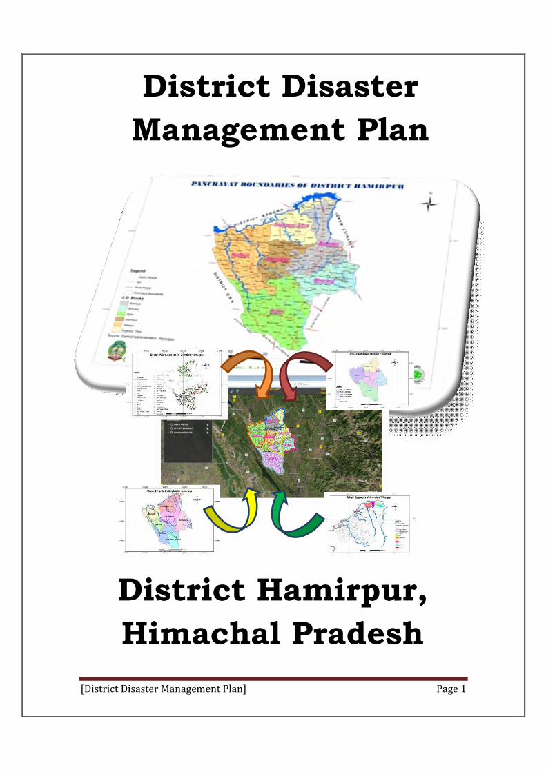
District Disaster
Management Plan
District Hamirpur,
Himachal Pradesh
[District Disaster Management Plan] Page 2
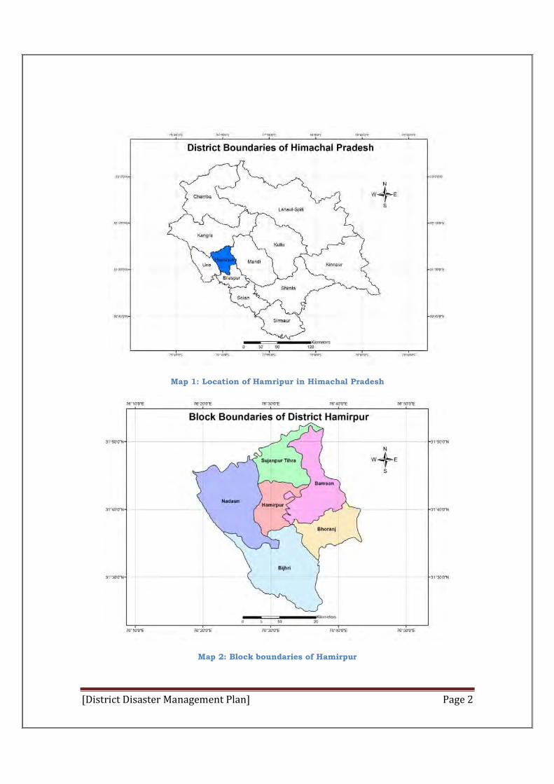
Map 1: Location of Hamripur in Himachal Pradesh
Map 2: Block boundaries of Hamirpur
[District Disaster Management Plan] Page 3
District Disaster Management Plan
Hamirpur
Overall Guidance - Shri Madan Chauhan (IAS)
Deputy Commissioner
Supervision - Mrs. Rupali Thakur, ADC
Coordination - Shri Bal Krishan Chaudhary,
DRO

[District Disaster Management Plan] Page 4
izkDdFku
21oha lnh ds izkjfEHkd o’kksZ esa vkink izcU/ku eqík fo”o esa ekuoh; dq”ky{kse ls tqM+h izeq[k fpark ds :Ik esa lkeus vk;k gSA orZeku esa ;s v/;;u dk vewrZ fo’k; ugha jgk gS vfirq bldk ljksdkj gekjh HkkSfrd izd`fr] gekjs ekufld o “kkjhfjd LokLF;] laLd`fr ] fodkl ds lja{k.k o [kq”kgkyh ds volj rFkk gekjs vfLrRo ls gSA
vkink lacU/kh [krjs dks eq[;r% izkd`frd o ekuo d`r nks oxksZ esa foHkkftr fd;k tk ldrk gSA
Izkkd`frd vkink ls gekjk rkRi;Z ok;qe.My ]tye.My] HkwxHkZ ¼HkwdEi o Tokykeq[kh½ esa gksus okyh ,slh ?kVukvksa o izHkkoksa ls gS ftudh xaHkhjrk o vko`fr euq’; rFkk mldh xfrfof/k;ksa rFkk ljapukvksa ij izfrdwy vlj Mkyus dh {kerk j[krh gSA izkd`frd vkinkvksa dks jksdk ugha tk ldrk gS ijUrq dq”ky izca/ku }kjk buds dqizHkkoksa dks de fd;k tk ldrk gSA
Rksth ls fodflr gksrh gqbZ rduhd vkSj vkfFkZd iz.kkyh }kjk lqlfTtr gekjh vk/kqfud lH;rk viuh xfrfof/k;ksa ] nkf;Roghu izdf̀r nksgu rFkk vuqRrjnk;h fodkl }kjk fujarj vkink lacU/khj [krjs dks c<+kok ns jgh gSA gekjs tSoe.My dh thou dks vk/kkj nsus okyh iz.kkyh rsth ls u’V gks jgh gSA blds QyLo:Ik mRiUu vkinkvksa }kjk u flQZ ekuo tkfr dk Hkfo’; [krjs esa iM+ x;k gS] cfYd /kjrh ij lewps thou dk vfLrRo Hk;adj [krjs esa gSA
vkink izcaU/ku ;kstuk ds fuekZ.k rFkk fdz;kUo;u dh i`’BHkwfe esa gekjk eq[; mís”; ukxfjdksa ds thou laifRr rFkk fodkl ds ykHkksa dk laj{k.k fufgr gS bl ;kstuk ds izpkj o izlkj }kjk ge Hkh lqfuf”pr djsaxsa fd vkink ls iwoZ ] nkSjku rFkk Ik;ZUr ukxfjd fdl izdkj dh lko/kkfu;ka ys ldrs gS rFkk viuh lqj{kk gsrq og dSls O;fDrxr iz;kl dj ldrs gSA
vkink lacU/kh rS;kjh ds fy, vko”;d gS fd lHkh fgr/kkjdksa ds chp usVofdZx gksA ;|fi vkink izca/ku esa jktLo foHkkx dh dsUnzh; Hkwfedk gS rFkkfi dksbZ Hkh ,dy foHkkx rc rd visf{kr ifj.kke ikus esa lQy ugha gksxk tc rd fd vU; izR;sd foHkkx viuh&2 ftEesnkfj;ksa dks lgh izdkj ls le>rs gq, xaHkhjrk ls viuh Hkwfedk dk fuoZgu u djsA vr% fu’d’kZr% ;s fo”okliwoZd dgk tk ldrk gS fd lQy vkink izcU/ku ds fy, lHkh foHkkxksa vkSj fgr/kkjdksa ds ,dhd`r iz;kl vko”;d gSA
vUr esa rRdkyhu bZ- vuqie dqekj MMoky rglhynkj (fjdojha) o cyoku pUn ] mi e.My vf/kdkjh ¼uk0-½ Hkksjat dks Hkh /kU;okn djuk pkgrk gaw ftUgksus ftyk vkink izac/ku ;kstuk ds fuekZ.k gsrq lwpuk ladyu] :iys[kk fuekZ.k ] ys[ku vkSj daI;wVjhdj.k dk Jelk/; dk;Z fd;k gSA
enu pksgku ¼Hkk0iz0ls0½ mik;qDr gehjiqjA
[District Disaster Management Plan] Page 5
Table of Contents List of Maps: ................................................................................................ 10
List of tables: ............................................................................................... 10
Chapter-I ..................................................................................................... 12
Introduction .............................................................................................. 12
1.1 National Vision ................................................................................. 12
1.2 Purpose of District Disaster Management Plan ................................... 12
1.3 Key Objectives .................................................................................. 12
1.4 District Disaster Management Plan: An Approach .............................. 13
1.5 GOAL OF DISTRICT DISASTER MANAGEMENT PLAN ...................... 144
1.6 WHY MULTI HAZARD APPROACH???........ ..................................... 15
1.7 PROBABLE HAZARDS IN DISTRICT:- ................................................ 15
Chapter-II .................................................................................................. 166
District Profile of Hamirpur ...................................................................... 166
2.1 Administrative set-up .................................................................... 166
Demographic Profile of the Hamirpur District : Census 2011 data ......................... 19
An official Census 2011 detail of Hamirpur, a district of Himachal Pradesh has
been released by Directorate of Census Operations in Himachal Pradesh. ....... 19
Physical features .................................................................................... 20
Physiographic ........................................................................................ 20
(i) Western Hamirpur Forested Shivalik: .................................................. 21
(ii) Eastern Hamirpur Shivalik: .............................................................. 22
(iii) Beas Basin: ..................................................................................... 22
Climate: ................................................................................................. 24
Forests: ................................................................................................. 28
(i)Slikhiwa Chil Pine Forests: ................................................................ 288
(ii)Northern Dry Mixed Deciduous forests: ............................................... 29
Fauna .................................................................................................... 29
Minerals and Mining .............................................................................. 29
Soil and Cropping Pattern ....................................................................... 29
Land, Land use Pattern and Tenancy ...................................................... 29
Agriculture ............................................................................................. 30
Irrigation .............................................................................................. 311
[District Disaster Management Plan] Page 6
Horticulture ......................................................................................... 331
Sericulture ........................................................................................... 322
Animal Husbandry ............................................................................... 322
Fisheries .............................................................................................. 333
Industries ............................................................................................ 333
Health.................................................................................................. 344
Education ............................................................................................ 344
Trade, Commerce and Banking ............................................................. 344
Transport ............................................................................................. 355
Gram Panchayats ................................................................................. 366
Chapter-III ................................................................................................. 388
Hazard, Risk, Vulnerability and Capacity Analysis ...................................... 38
3.1Hazards & Vulnerability In Hamirpur ............................................... 388
EARTHQUAKE .................................................................................. 39-41
LANDSLIDES, DEBRIS FLOW AND SUBSIDENCE ................................. 411
DROUGHT: .......................................................................................... 422
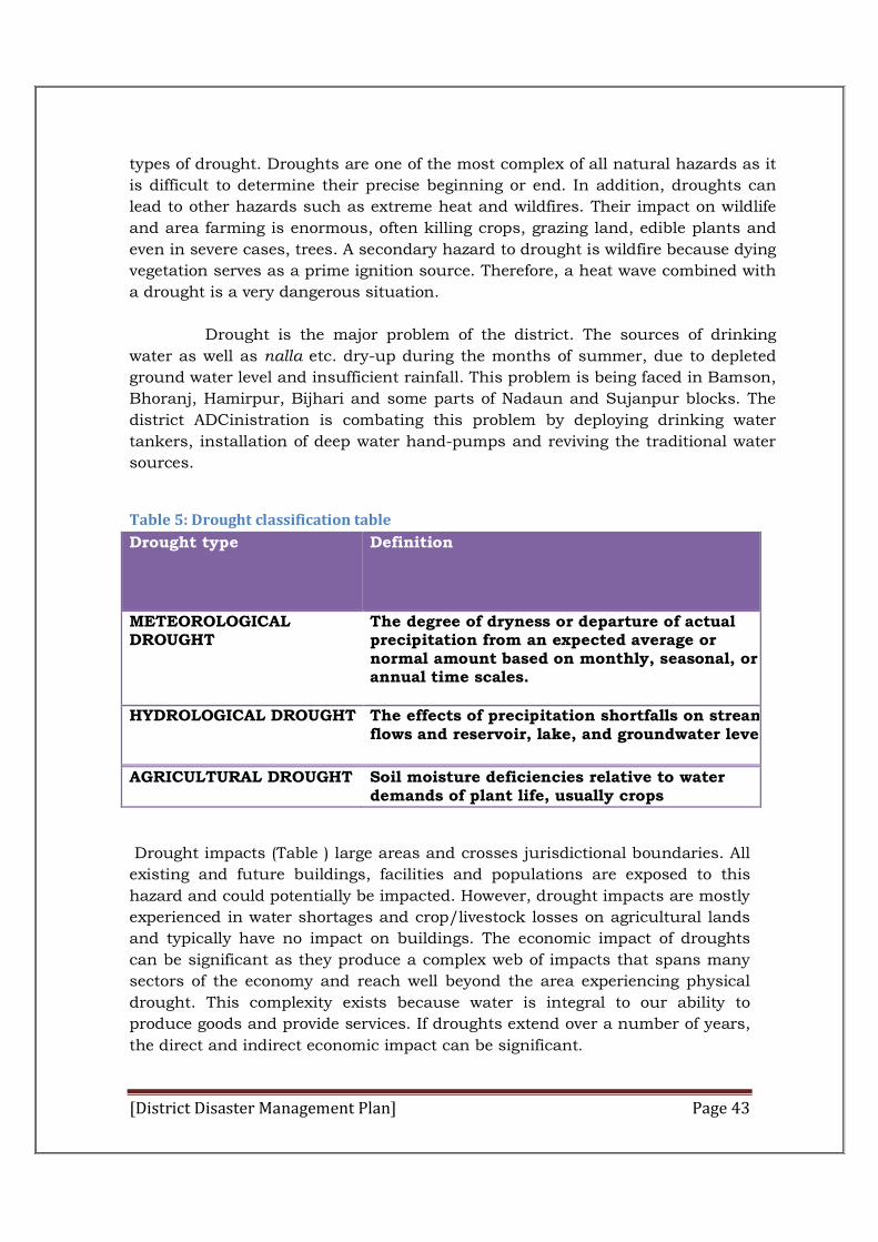
Table 4: Drought classification table ..................................................... 433
FLOODS: ............................................................................................. 444
FOREST FIRE AND URBAN, RURAL FIRE: ............................................ 455
Road Traffic Injuries and Deaths ........................................................... 466
3.2 Risk Identification ……………………………………………………………….. 47
3.3 Overall vulnerability of District Hamirpur……………………………………47
3.4 History of Disaster and Hazard profile of District Hamirpur…………….48
Chapter-IV ................................................................................................. 511
Institutional Mechanism .......................................................................... 511
4.1 Institutional Mechanism: ................................................................ 511
District Disaster Management Authority ............................................. 51-54
District Disaster Management Advisory Committee ................................ 544
Sl No Appointment/Name Designation in the Committee ....................... 544
Organization and Responsibility ............................................................ 555
SUB-DIVISIONAL LEVEL DISASTER MANAGEMENT COMMITTEE: ........ 566
TEHSIL LEVEL DISASTER MANAGEMENT COMMITTEE: ...................... 577
[District Disaster Management Plan] Page 7
BLOCK LEVEL DISASTER MANAGEMENT COMMITTEE: ....................... 588
SUB-TEHSIL LEVEL DISASTER MANAGEMENT COMMITTEE:................. 59
Gram Panchayat/Village Disaster Management Committee .................... 600
4.2 Other Institutional Arrangements.......................................................62
4.3 District Emergency Operation Centre (DEOC)......................................63
Measures to be taken for Disaster Management.........................................64
Functioning of the Emergency Operation Centre........................................65
4.4 TRIGGER MECHANISM & INCIDENT RESPONSE SYSTEM (IRS) ...... 666
Chapter-V ............................................................................................ 688
Mitigation Plan ........................................................................................ 688
5.1 MITIGATION PLAN ......................................................................... 688
5.2 Community Level Training and Public Awareness Activities: ............... 71
5.3 Local Level Preparedness....................................................................71
5.4 Primary agencies for community level training and public awareness
are: ...................................................................................................... 722
5.5 Mobilizing Community Efforts for Mitigation Measures: .................... 722
CULTURE OF MITIGATION: .................................................................. 733
Culture of Strategic Thinking: ............................................................... 744
5.6 Hazard Specific Mitigation Plan...........................................................74
Action Plan for Earthquake Mitigation......................................................74
Action Plan for Landslide Mitigation..........................................................75
Action Plan for Drought Mitigation............................................................76
Action Plan for Fire Mitigation...................................................................77
Mitigation Strategy for Fire.......................................................................77
Illustrations of various Govt. Schemes & Development Programme...........77
Chapter-VI ................................................................................................. 800
6.1 Response Plan .................................................................................. 800
Roles and Responsibilities of District Magistrate as RO ............................ 80
Roles of Local Authorities PRIs and ULBs .............................................. 811
Response Structure……………………………………………………………………82
[District Disaster Management Plan] Page 8
Incident Response System (IRS) & Incident Response Team (IRT) ............. 82
Incident Response System (IRS) - Facilities ............................................ 833
Incident Command Post (ICP) ............................................................... 833
Deployment of IRT ................................................................................ 844
Objectives of the Emergency Operations Centre ..................................... 844
Location of EOC ................................................................................... 844
Communication Network of EOCs ......................................................... 844
DEOC .................................................................................................. 855
DEOC Layout ......................................................................................... 85
Equipment Requirements ..................................................................... 866
Resource Inventories ............................................................................ 866
Inventories include the following basic elements, and other locally relevant
information: ......................................................................................... 877
6.2 Roles and Responsibilities of Nodal Agencies (General) ................ 89-101
Chapter-VII .............................................................................................. 1022
Standard Operating Procedures for Responsible (SOPs)…………………….1022
The Objectives of SOPs………………………………………………………………….102
Department of Revenue and Relief ......................................................... 1022
Police Department .............................................................................. 1044
Department of Transport .................................................................... 1055
Department of Public Works ............................................................... 1066
Department of Irrigation and Public Health ......................................... 1077
Department of Agriculture .................................................................. 1088
Department of Animal Husbandry ....................................................... 1099
Department of Education .................................................................... 1100
Department of Technical Education and vocational training ................. 1100
Department of Rural Development ...................................................... 1111
Department of Health ......................................................................... 1111
Forest Department ............................................................................. 1122
Department of Urban Development ..................................................... 1122
Department of Food, civil supplies and consumer affairs ...................... 1133
Department of PanchayatiRaj ............................................................. 1144
Department of Information and Public Relations .................................. 1144
[District Disaster Management Plan] Page 9
Department of Power .......................................................................... 1155
District Disaster management Plan, Hamirpur .................................... 1155
Department of Social Justice and Empowerment ................................... 116
Indian Red Cross and National NGOs .................................................... 116
THE EMERGENCY SUPPORT FUNCTIONS ............................................ 118
Emergency Support Functions (ESFs) Plan at District Level ................... 120
Primary and Secondary Agencies .......................................................... 121
SOPs OF EACH HAZARD ...................................................................... 124
Earthquake-Pre Disaster Preventive Measure ........................................ 124
II. Identification of target groups:- .................................................... 125
III. Strategies Regarding “Pre Earthquake Preventing Measures”:- ...... 126
Involvement of NIT/SRI for conducting training and workshops: ............ 126
Additional Concrete and reinforcement required: ................................... 127
IV. Awareness about “ Safety Measures And Techniques”:- ..................... 128
EARTHQUAKE –PREDISASTER PREVENTIVE MEASURES: ................ 12929
FOREST FIRE AND URBAN, RURAL FIRE: ............................................ 131
Chapter-VIII Relief, Recovery, Rehabitilation & Reconstruction Plan..............132
Chapter-IX Financial Provision & Implementation of DDMP..........................135
Chapter-X Monitoring, Evaluation, Updation & Maintainance of
DDMP..........137
PART II ...................................................................................................... 138
ANNEXURE ................................................................................................ 138
LIST OF NODAL OFFICERS ..................................................................... 139
District Disaster Resource Inventory..........................................................158
Resource Inventory Available in the district...................................................159
Office of the Superintendent of Police, District- Hamirpur Himachal
Pradesh……………………………………………………………………………………..159
Police Stations and available of Staff.............................................................159
Commandant Home Guard 10th Battalion Hamirpur District.........................160
Nehru Yuva Kendra Sangathan Organization, Hamirpur...............................161
Health and Family Welfare Department, Hamirpur........................................162
[District Disaster Management Plan] Page 10
Other Rescue Operation Tools available in the District Hamirpur..................163
Format for First Information Report on occurrence of natural calamity ......... 165
DAMAGE ASSESSMENT FORMS: ................................................................ 166
List of Maps: MAP 1: LOCATION OF HAMRIPUR IN HIMACHAL PRADESH ....................................................... 2 MAP 2: BLOCK BOUNDARIES OF HAMIRPUR ......................................................................... 2 MAP 3: TEHSIL MAP OF HAMIRPUR ................................................................................... 17 MAP 4: BLOCK MAP OF HAMIRPUR ................................................................................... 18 MAP 5: POLICE CIRCLES OF HAMIRPUR ............................................................................. 19 MAP 6: LAND COVER MAP OF HAMIRPUR ........................................................................... 21 MAP 7: DRAINAGE MAP OF HAMIRPUR............................................................................... 24 MAP 8:RAINFALL PATTERN MAP OF HAMIRPUR .................................................................... 28 MAP 9: ROAD NETWORK OF HAMIRPUR ............................................................................. 36 MAP 10: PANCHAYAT MAP OF HAMIRPUR ........................................................................... 37 MAP 11: EARTH QUAKE HAZARD MAP OF HAMIRPUR ............................................................ 41
MAP12: LANDSLIDE HAZARD MAP OF HAMIRPU.................................................……42
MAP13: VULNERABLE VILLAGES FOR FLASH FLOODS……………………………….……45
MAP 14: FOREST FIRE HAZARD MAP OF HAMIRPUR…………………………………….….46
MAP 15: OVERALL VULNERABILITY MAP……………………………………………………….48
List of figures: FIGURE 1: DISASTER MANAGEMENT HOLISTIC MODEL .......................................................... 13 FIGURE 2: DISTRICT-LEVEL INCIDENT COMMAND TEAM CORE MANAGEMENT STRUCTURE ........... 67 FIGURE 3: CULTURE OF PREPAREDNESS ........................................................................... 73 FIGURE 4: CULTURE OF STRATEGIC THINKING ................................................................... 74 FIGURE 5:IRS STRUCTURE ............................................ ERROR! BOOKMARK NOT DEFINED.
FIGURE6: IRT FRAMEWORK………………………………………………………………………..83
Figure 7: Conceptual Layout of Emergency Operations Centre…………….. 86
FIGURE 8: REVENUE DEPARTMENT STRUCTURE ............................................................... 104
List of tables: TABLE 1 DETAIL OF SUBDIVISIONS, TEHSILS, SUBTEHSILS, KANGO CIRCLES, PATWAR CIRCLES IN
HAMIRPUR DISTRICT .............................................................................................. 16 TABLE 2: BANK BRANCHES IN HAMIRPUR .......................................................................... 35 TABLE 3 BLOCK WISE NUMBER OF PANCHAYAT ................................................................... 37 TABLE 4 TYPES OF DISASTER IN HAMIRPUR DISTRICT…………………………………….……………39 TABLE 5: DROUGHT CLASSIFICATION TABLE ....................................................................... 43 TABLE 6: DROUGHT CATEGORIES AND IMPACTS .................................................................. 44
[District Disaster Management Plan] Page 11
TABLE 7 FLASH FLOOD VULNERABLE VILLAGES ................................................................... 44 TABLE 8: RISK ASSESSMENT TABLE .................................................................................. 48
TABLE 9: DISTRICTS OF HIMACHAL PRADESH WITH SEISMIC INTENSITIES .............................. 4118
TABLE 10: ROAD TRAFFIC INJURIES AND DEATHS……………………………………………………..50
TABLE11: ILLUSTRATION OF VARIOUS GOVT. SCHEMES & DEVELOPMENT
PROGRAMME…………………………………………………………………………………………..79
TABLE12: ROLES AND RESPONSIBILTIES OF THE ESF…………………………………118
TABLE 13: PRIMARY AGENCY FOR EACH ESF .................................................................. 121 TABLE 14 :LIST OF NODAL OFFICERS ............................................................................. 139 TABLE 15: TELEPHONE DIRECTORY OF OFFICERS IN RESPECT OF DISTRICT HAMIRPUR ............ 141 TABLE 16: OFFICE OF THE SUPERINTENDENT OF POLICE , HAMIRPUR ................................... 143 TABLE 17: OFFICE OF THE CHIEF MEDICAL OFFICER, HAMIRPUR ........................................ 143 TABLE 18: OFFICE OF THE EXECUTIVE ENGINEER (C&W) OPERATION CIRCLE ...................... 144 TABLE 19: OFFICE OF THE COMMANDANT HOME GUARDS 10TH BATTALION, HAMIRPUR ........... 144 TABLE 20: OFFICE OF THE EXECUTIVE ENGINEER, IPH DIVISION BARSAR. ....................... 14545 TABLE 21: OFFICE OF THE EXECUTIVE ENGINEER , HAMIRPUR DIVISION HPPWD, HAMIRPUR . 145 TABLE 22: OFFICE OF THE EXECUTIVE ENGINEER, BARSAR DIVISION HPPWD BARSAR .......... 146 TABLE 23: OFFICE OF THE EXECUTIVE ENGINEER, TAUNIDEVI DIVISION HPPWD TAUNIDEVI.. 147
TABLE 24: OFFICE OF THE ANIMAL HUSBANDARY, HAMIRPUR………………………147
TABLE 25: STATUS OF GOSADANS IN RESPECT OF HAMIRPUR DISTRICT………….147
TABLE 26: LIST OF NODAL OFFICERS IN GOSADANS IN DISTRICT HAMIRPUR……149
TABLE 27: LIST OF VOLUNTEERS SELECTED FOR DISASTER MANAGEMENRT
(DDRR) BY NYK HAMIRPUR……………………………………………………………………….150
TABLE 28: LIST OF LIFE LINE BUILDINGS IN DISTRICT HAMIRPUR…………………153
TABLE 29: HELICOPTER REQUEST……………………………………………………………156
[District Disaster Management Plan] Page 12
Chapter-I
Introduction
1.1 National Vision
The national vision is to build a safer and disaster resilient India
by developing a holistic, proactive, multi-disaster and technology driven
strategy for DM. This will be achieved through a culture of prevention,
mitigation and preparedness to reduce the impact of disasters on people. The
entire process will centre stage the community and will be provided momentum
and sustenance through the collective efforts of all goverment agencies
supported by Non-Governmental Organizations (NGOs).
1.2 Purpose of District Disaster Management Plan
To respond promptly in a coordinated manner in a disaster like
situation, it is mandatory to mitigate the potential impact of disasters in order
to save lives of people and property in Hamirpur District.
1.3 Key Objectives
The aim of the district plan is to ensure that the following components of Disaster Management (DM) are addressed to facilitate planning, preparedness, operational, coordination and community participation. Flowing from the national vision and the aforementioned approach, the objectives & guiding principles for the plan formulation are:
Promoting a culture of prevention and preparedness by ensuring that DM receives the highest priority at all levels.
Ensuring that community is the most important stakeholder in the DM process.
Encouraging mitigation measures based on state-of-the-art technology and environmental sustainability.
Mainstreaming DM concerns into the developmental planning process. Developing contemporary forecasting and early warning systems backed
by responsive and fail-safe communications and Information Technology (IT) support.
Promoting a productive partnership with the media to create awareness and contributing towards capacity development.
Ensuring efficient response and relief with a caring approach towards the needs of the vulnerable sections of the society.
Undertaking reconstruction as an opportunity to build disaster resilient structures and habitat.
Undertaking recovery to bring back the community to a better and safer level than the pre-disaster stage
[District Disaster Management Plan] Page 13
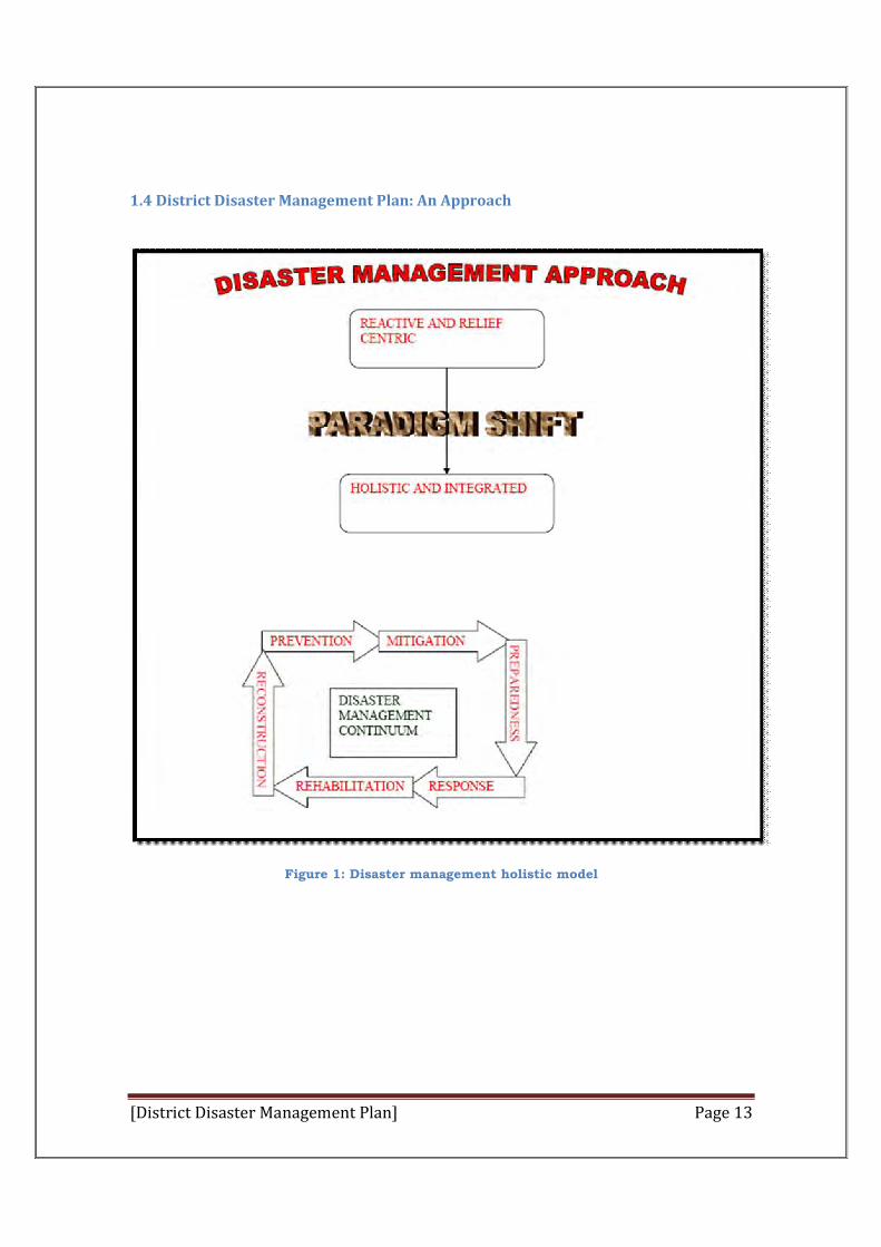
1.4 District Disaster Management Plan: An Approach
Figure 1: Disaster management holistic model
[District Disaster Management Plan] Page 14
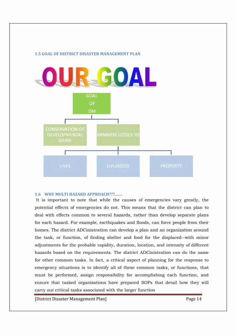
1.5 GOAL OF DISTRICT DISASTER MANAGEMENT PLAN
1.6 WHY MULTI HAZARD APPROACH???........
It is important to note that while the causes of emergencies vary greatly, the
potential effects of emergencies do not. This means that the district can plan to
deal with effects common to several hazards, rather than develop separate plans
for each hazard. For example, earthquakes and floods, can force people from their
homes. The district ADCinistration can develop a plan and an organization around
the task, or function, of finding shelter and food for the displaced--with minor
adjustments for the probable rapidity, duration, location, and intensity of different
hazards based on the requirements. The district ADCinistration can do the same
for other common tasks. In fact, a critical aspect of planning for the response to
emergency situations is to identify all of these common tasks, or functions, that
must be performed, assign responsibility for accomplishing each function, and
ensure that tasked organizations have prepared SOPs that detail how they will
carry out critical tasks associated with the larger function
[District Disaster Management Plan] Page 15
1.7 PROBABLE HAZARDS IN DISTRICT:-
The state of Himachal Pradesh is susceptible to 25 types of hazard according to
Himachal Pradesh state disaster management plan. Hamirpur district which is
situated in lower Shivalik hills is vulnerable to 24 of them.
There are five types of hazard to which Hamirpur District is prone to
(A) Geologically related hazards
Earth quake Land slide and fluid flow Dam failure
(B) Water and climate the related hazards
Floods Hail storm Heat wave and cold wave Droughts Thunder and lightening Cloud burst
(C)Chemical industrial and nuclear hazards
Chemical and industrial disaster Nuclear disaster
(D) Accident related hazards
Forest Fire Urban Fire Major Building Collapse Serial Bomb Blast Festival related disasters Electrical Disasters and Fires Air, Road accidents Boat Capsizing Village Fire
(E) Biologically Related hazards
Biological Disasters and Epidemics Pest Attacks Cattle Epidemics Food Poisoning
[District Disaster Management Plan] Page 16
Chapter-II
District Profile of Hamirpur
2.1 Administrative set-up
The district is located in the south-western part of the state and
constitutes a part of Central Himachal Pradesh micro region. Presently district
has five tehsils viz. Hamirpur, Barsar, Bhoranj, Nadaun and Tira Sujanpur and
two sub-tehsils i.e. Dhatwal with headquarters at Bijhri and Galore.
The district is divided into four Revenue Sub-divisions namely Hamirpur,
Barsar Nadaun and Bhoranj having their headquarters at the same place(Table
1). The Hamirpur sub-division is comprised of tehsil Hamirpur and Tira
Sujanpur, Barsar sub-division comprises of Barsar tehsil and sub-tehsil
Dhatwal. Whereas Nadaun sub-division has tehsil of Nadaun and sub-tehsil
Galore, Bhoranj sub-division has single tehsil at Bhoranj.
Table 1 Detail of subdivisions, Tehsils, Subtehsils, Kango circles, Patwar circles in Hamirpur District
Subdivisions Tehsil/Subtehsil Kanungo Circles Patwar circles
(1) Hamirpur Hamirpur (Tehsil) 05 35
Taunidevi 01 19
(2) Sujanpur Sujanpur (Tehsil) 02 24
(3) Bhoranj Bhoranj (Tehsil) 04 34
(4) Barsar Barsar (Tehsil) 03 26
Dhatwal ( Subtehsil)
01 17
(5) Nadaun Nadaun(Tehsil) 03 28
Galore (Subtehsil)
01 15
[District Disaster Management Plan] Page 17
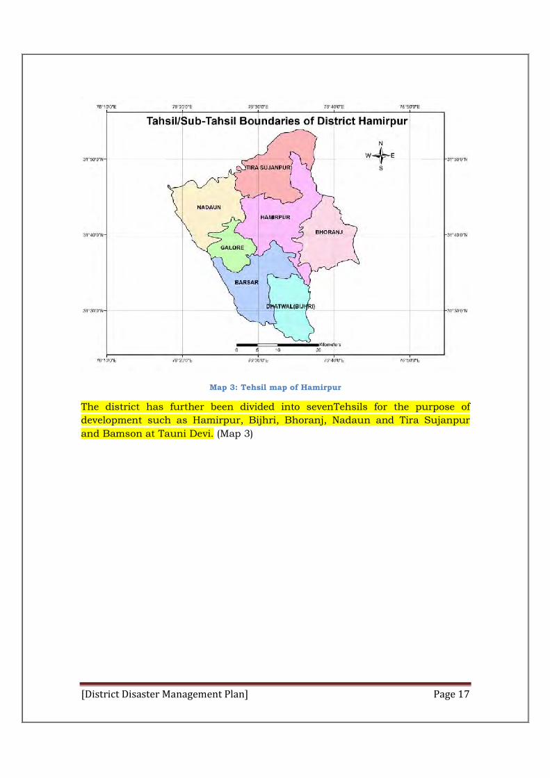
Map 3: Tehsil map of Hamirpur
The district has further been divided into sevenTehsils for the purpose of
development such as Hamirpur, Bijhri, Bhoranj, Nadaun and Tira Sujanpur
and Bamson at Tauni Devi. (Map 3)
[District Disaster Management Plan] Page 18
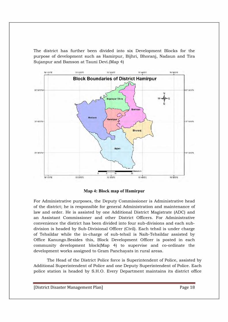
The district has further been divided into six Development Blocks for the
purpose of development such as Hamirpur, Bijhri, Bhoranj, Nadaun and Tira
Sujanpur and Bamson at Tauni Devi.(Map 4)
Map 4: Block map of Hamirpur
For Administrative purposes, the Deputy Commissioner is Administrative head
of the district; he is responsible for general Administration and maintenance of
law and order. He is assisted by one Additional District Magistrate (ADC) and
an Assistant Commissioner and other District Officers. For Administrative
convenience the district has been divided into four sub-divisions and each sub-
division is headed by Sub-Divisional Officer (Civil). Each tehsil is under charge
of Tehsildar while the in-charge of sub-tehsil is Naib-Tehsildar assisted by
Office Kanungo.Besides this, Block Development Officer is posted in each
community development block(Map 4) to supervise and co-ordinate the
development works assigned to Gram Panchayats in rural areas.
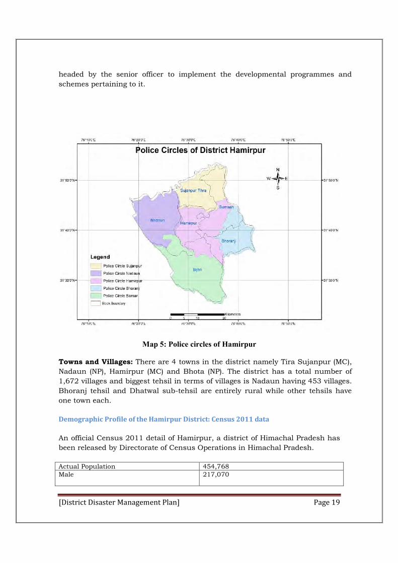
The Head of the District Police force is Superintendent of Police, assisted by
Additional Superintendent of Police and one Deputy Superintendent of Police. Each
police station is headed by S.H.O. Every Department maintains its district office
[District Disaster Management Plan] Page 19
headed by the senior officer to implement the developmental programmes and
schemes pertaining to it.
Map 5: Police circles of Hamirpur
Towns and Villages: There are 4 towns in the district namely Tira Sujanpur (MC),
Nadaun (NP), Hamirpur (MC) and Bhota (NP). The district has a total number of
1,672 villages and biggest tehsil in terms of villages is Nadaun having 453 villages.
Bhoranj tehsil and Dhatwal sub-tehsil are entirely rural while other tehsils have
one town each.
Demographic Profile of the Hamirpur District: Census 2011 data
An official Census 2011 detail of Hamirpur, a district of Himachal Pradesh has
been released by Directorate of Census Operations in Himachal Pradesh.
Actual Population 454,768 Male 217,070

[District Disaster Management Plan] Page 20
Female 237,698
Population Growth 10.19%
Area Sq. Km 1,118 Density/km 2 407
Proportion to Himachal Pradesh Population 6.62% Sex Ratio (Per 1000) 1095
Child Sex Ratio (0-6 Age) 887
Average Literacy 88.15
Male Literacy 94.36 Female Literacy 82.62 Total Child Population (0-6 Age) 48,548 Male Population (0-6 Age) 25,722 Female Population (0-6 Age) 22,826
Literates 358,091
Male Literates 180,555 Female Literates 177,536 Child Proportion (0-6 Age) 10.68%
Boys Proportion (0-6 Age) 11.85% Girls Proportion (0-6 Age) 9.60%
Physical features
The district is located in the south-western part of the state. It forms a
part of central Himachal Pradesh and is situated predominantly in outer
Himalaya or Shiwalik Zone. It lies between 310 24’ 48” and 310 53’ 35” North
latitudes and 760 17’ 50” and 760 43’ 42” east longitudes and is separated from
Kangra district by the Beas river in the north, Bakara and Sir Khads from
Mandi District in the east while Una District falls in its west and Bilaspur
District touches it in the south.
Physiographic
Physiographically the entire tract of this District is hilly and Covered by
lower Himalayas known as Shiwalik range. The elevation of this District varies
between 470 metres and 1,235 metres the mean sea level. The District has
many low hill ranges which run north-west to south-east direction and of them
Jajiar Jakh Dhar, Chaumukhi Dhar, Sola Singhi Dhar and Chabutra Dhar are
prominent. Jhak Dhar runs in continuation of kali Dhar range in Kangra
District. It enters in Hamirpur District near Nadaun and traverses it into south-
eastern direction. The town of Hamirpur lies to the east of this range where
country is undulating but in north and north-east bare and rugged hills. Deep
[District Disaster Management Plan] Page 21
ravines with precipitous sides transforms the landscape into what has been
described as an agitated sea suddenly arrested and fixed stones. The Chabutra
hills have the same dip and strike as in the Jakh Dhar and are continued
beyond the Beas to what is known as the Changar, a mass of rugged and
broken hills. Sola Singhi Dhar is longest range of the tract and is known is
known under various names such as Chintpurni and Jaswan Dhar in Una and
by Sola Singhi Dhar in Hamirpur. Thus Dhar enters Hamirpur to the east of
tappa Daruhi and traverses it in a south-easterly direction more or less parallel
to the Jakh Dhar and terminated on the Satluj. Main Khads of this District are
Bakar, Kunah, Man, Pung, Sukar and Sir Khads. Sukar Khad drains into Sir
khad which ultimately merges in the Satluj river outside the District while all
other khads drain into the Beas river. The valleys of these khads are almost flat
and fertile. The District falls in the humid sub-tropical zone and mean annual
rainfall varies between 1,000 to 1,400mm.
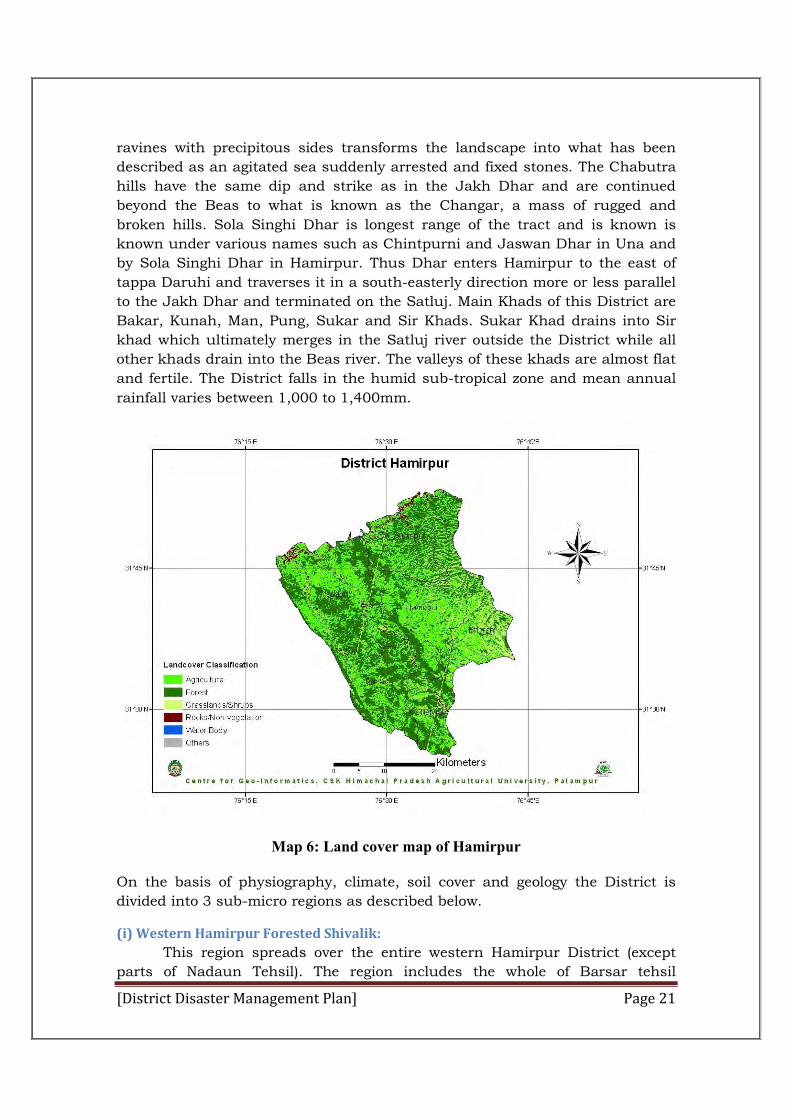
Map 6: Land cover map of Hamirpur
On the basis of physiography, climate, soil cover and geology the District is
divided into 3 sub-micro regions as described below.
(i) Western Hamirpur Forested Shivalik:
This region spreads over the entire western Hamirpur District (except
parts of Nadaun Tehsil). The region includes the whole of Barsar tehsil
[District Disaster Management Plan] Page 22
excluding north-eastern corner, southern Nadaun tehsil, small pocket of south-
western Tira Sujanpur tehsil and south-western part of Hamirpur tehsil (Map
1). It makes its limits with Beas basin in the north, Una District in the west,
Bilaspur District in the south and eastern Hamirpur Shiwalik region in the
east. In terms of area, this region is one of the biggest sub-micro regions of the
district. This region has many low hills and fertile valleys with an altitude
ranging from 518 metres to 1,112 metres above the mean sea level. According
to village papers the area of the entire region comes to 483.70 sq. kms. The
prominent Dhars falling in this region are Chaumukhi Dhar, Sola Singhi Dhar
and Jajiar Jakh Dhar.
(ii) Eastern Hamirpur Shivalik:
The region is situated in the eastern Hamirpur embracing whole of
Bhoranj tehsil, major parts of Hamirpur tehsil except north-eastern and south-
western parts and small pockets of Barsar tehsil. It is surrounded by BeasBasin
from north-west Hamirpur forested Shivalik from west, Bilaspur district from
south and Mandi district from east. This region is most populous among all the
three regions of the district.
The region is undualating and contains fertile valleys along the streams.
The elevation of this region varies between 710 metres and 1,235 metres above
the mean sea level. The total area of this region comes out to 318.76 sq.kms.
(iii) Beas Basin:
This region extends over northern Hamirpur district, covering whole of
Tira Sujanpur tehsil except its north-western part, north-eastern fringe of
Hamirpur tehsil and northern part of Nadaun tehsil. The northern boundary of
this region is formed by Beas river which flows from east to westerly direction
and separates it from Kangra district. In the east, Bakar khad makes its limit
and separates it from Mandi district while in the south it is bounded by eastern
Hamirpur Shivalik and western Hamirpur forested Shivalik regions. Masinh
khad makes its western limit and separates it from Kangra district. The region
is long in the east-west and narrow in width.
This region is characterized by low hills and fertile valleys with an
altitude ranging from 470 metres to 1,078 metres above the mean sea level. The
total area of this region comes to 300.12 sq. kms.
The geological structure of this district is mainly formed of Shivalik
formations. In this district, upper reaches of Jajiar Jakh, Sola Singhi and
Chaumukhi Dhars have fairly dense concentration of chir forests while thin
vegetation cover is found in lower areas. In north-eastern and eastern parts of
this district, scrub type of vegetation is found scattered here and there. The soil
in general is brown and varies in texture from loamy sand to clay loam but
under scientific analysis of the soils as classified by the N.B.S.S. and L.U.P.
[District Disaster Management Plan] Page 23
(I.C.A.R) Nagpur, soils are mainly ochrepts-orthents (72) whereas ochrepts (70),
orthents-ochrepts (58) and ochrepts-orthents-ustalfs (74) types of soils are
found in the northern and eastern parts of this district.
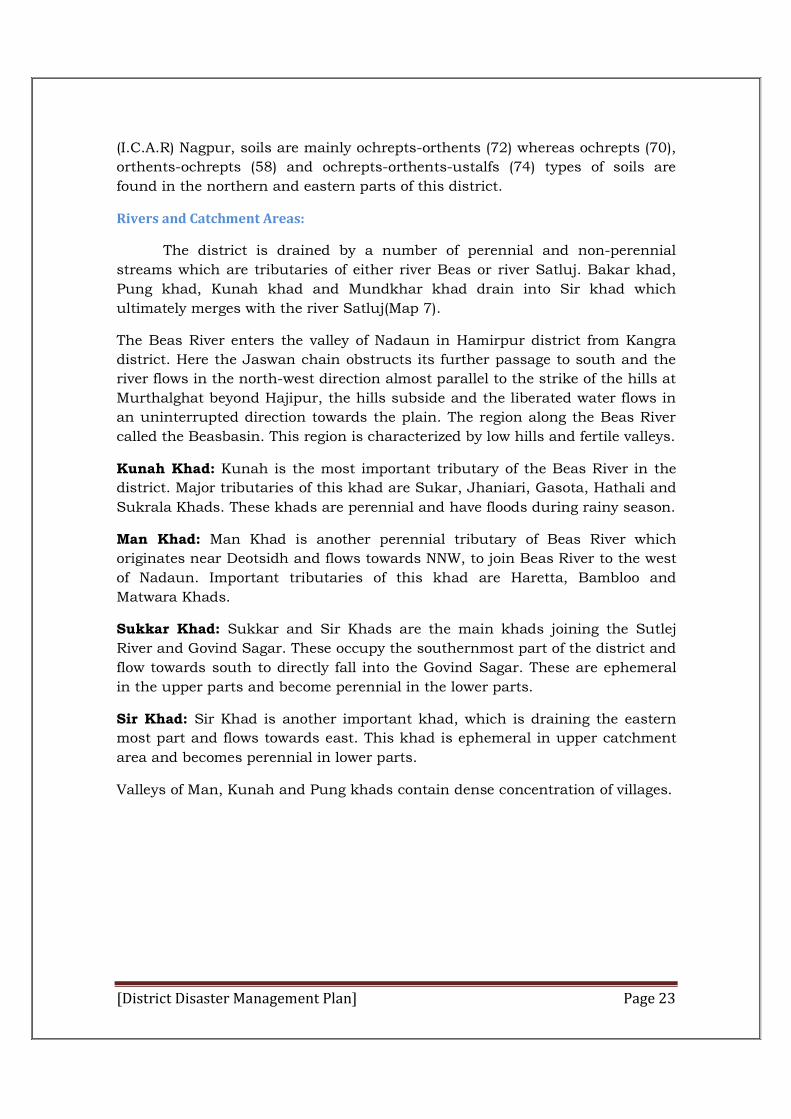
Rivers and Catchment Areas:
The district is drained by a number of perennial and non-perennial
streams which are tributaries of either river Beas or river Satluj. Bakar khad,
Pung khad, Kunah khad and Mundkhar khad drain into Sir khad which
ultimately merges with the river Satluj(Map 7).
The Beas River enters the valley of Nadaun in Hamirpur district from Kangra
district. Here the Jaswan chain obstructs its further passage to south and the
river flows in the north-west direction almost parallel to the strike of the hills at
Murthalghat beyond Hajipur, the hills subside and the liberated water flows in
an uninterrupted direction towards the plain. The region along the Beas River
called the Beasbasin. This region is characterized by low hills and fertile valleys.
Kunah Khad: Kunah is the most important tributary of the Beas River in the
district. Major tributaries of this khad are Sukar, Jhaniari, Gasota, Hathali and
Sukrala Khads. These khads are perennial and have floods during rainy season.
Man Khad: Man Khad is another perennial tributary of Beas River which
originates near Deotsidh and flows towards NNW, to join Beas River to the west
of Nadaun. Important tributaries of this khad are Haretta, Bambloo and
Matwara Khads.
Sukkar Khad: Sukkar and Sir Khads are the main khads joining the Sutlej
River and Govind Sagar. These occupy the southernmost part of the district and
flow towards south to directly fall into the Govind Sagar. These are ephemeral
in the upper parts and become perennial in the lower parts.
Sir Khad: Sir Khad is another important khad, which is draining the eastern
most part and flows towards east. This khad is ephemeral in upper catchment
area and becomes perennial in lower parts.
Valleys of Man, Kunah and Pung khads contain dense concentration of villages.
[District Disaster Management Plan] Page 24
Map 7: Drainage map of Hamirpur
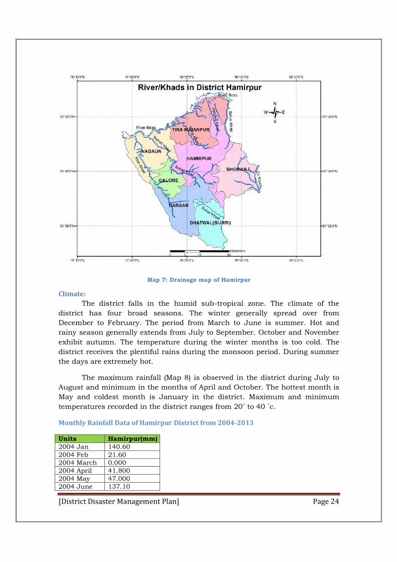
Climate:
The district falls in the humid sub-tropical zone. The climate of the
district has four broad seasons. The winter generally spread over from
December to February. The period from March to June is summer. Hot and
rainy season generally extends from July to September. October and November
exhibit autumn. The temperature during the winter months is too cold. The
district receives the plentiful rains during the monsoon period. During summer
the days are extremely hot.
The maximum rainfall (Map 8) is observed in the district during July to
August and minimum in the months of April and October. The hottest month is
May and coldest month is January in the district. Maximum and minimum
temperatures recorded in the district ranges from 20˚ to 40 ˚c.
Monthly Rainfall Data of Hamirpur District from 2004-2013
Units Hamirpur(mm) 2004 Jan 140.60 2004 Feb 21.60 2004 March 0.000 2004 April 41.800 2004 May 47.000 2004 June 137.10

[District Disaster Management Plan] Page 25
2004 July 303.600 2004 Aug 319.300 2004 Sept 98.300 2004 Oct 138.800 2004 Nov 3.100 2004 Dec 38.700 2005 Jan 70.200 2005 Feb 166.800 2005 March 74.400 2005 April 9.700 2005 May 23.000 2005 June 57.900 2005 July 407.600 2005 Aug 298.100 2005 Sept 141.700 2005 Oct 3.200 2005 Nov 0.000 2005 Dec 0.000 2006 Jan 57.200 2006 Feb 2.100 2006 March 99.700 2006 April 20.300 2006 May 112.000 2006 June 166.500 2006 July 482.900 2006 Aug 394.900 2006 Sept 189.000 2006 Oct 31.700 2006 Nov 7.000 2006 Dec 28.000 2007 Jan 0.000 2007 Feb 136.800 2007 March 163.100 2007 April 41.200 2007 May 33.100 2007 June 129.700 2007 July 247.200 2007 Aug 548.500 2007 Sept 95.200 2007 Oct 2.100 2007 Nov 0.000 2007 Dec 19.700 2008 Jan 41.900 2008 Feb 46.800 2008 March 0.000 2008 April 47.900 2008 May 57.900 2008 June 359.100 2008 July 325.800 2008 Aug 396.100 2008 Sept 111.800 2008 Oct 30.400 2008 Nov 0.000

[District Disaster Management Plan] Page 26
2008 Dec 1.000 2009 Jan 17.300 2009 Feb 20.100 2009 March 26.900 2009 April 43.500 2009 May 49.100 2009 June 55.200 2009 July 330.500 2009 Aug 403.700 2009 Sept 196.300 2009 Oct 9.400 2009 Nov 10.800 2009 Dec 0.000 2010 Jan 11.800 2010 Feb 52.200 2010 March 5.800 2010 April 4.700 2010 May 38.200 2010 June 118.100 2010 July 325.100 2010 Aug 346.400 2010 Sept 250.200 2010 Oct 12.900 2010 Nov 13.300 2010 Dec 67.700 2011 Jan 31.300 2011 Feb 109.600 2011 March 35.700 2011 April 40.800 2011 May 70.300 2011 June 240.700 2011 July 223.00 2011 Aug 512.100 2011 Sept 138.400 2011 Oct 3.300 2011 Nov 0.000 2011 Dec 15.200 2012 Jan 132.00 2012 Feb 32.100 2012 March 25.500 2012 April 44.900 2012 May 1.300 2012 June 14.800 2012 July 374.600 2012 Aug 557.300 2012 Sept 235.700 2012 Oct 5.000 2012 Nov 4.000 2012 Dec 28.100 2013 Jan 45.100 2013 Feb 121.400 2013 March 80.300 2013 April 9.700
[District Disaster Management Plan] Page 27
Source: IMD Govt. of India
Average annual rainfall data of Hamirpur District
Year Average annual rainfall(mm)
2004 1289.9
2005 1252.6
2006 1591.3
2007 1416.6
2008 1414.6
2009 1179.2
2010 1247.1
2011 1420.4
2012 1455.3
2013 1428.0
Source: Meterological Department Govt of India
2013 May 13.900 2013 June 295.000 2013 July 441.400 2013 Aug 280.800 2013 Sept 73.400 2013 Oct 24.400 2013 Nov 12.800 2013 Dec 29.800
[District Disaster Management Plan] Page 28
Map 8: Rainfall pattern map of Hamirpur
The climatic conditions prevailing in the district are very suitable for
growing citrus crops, forestry and other economic resources.
Forests:
The forest plays a vital role in shaping the characteristic of an area. Besides,
these also influence the economic and social life of the people considerably. The
forest provides valuable timber, medicinal herbs, and raw materials for
industries and also provides employment and plays a vital role in conserving
the soil and ensure timely rains. As per state forest report of 1999, forest area
in the District is 219 kms which constitutes 19.6 per cent of the total
geographical area of the district. According to a revised forest survey done by
H.G. Champion and S.K.Seth, the forests in this district have been classified in
the following types:
(i)Slikhiwa Chil Pine Forests:
The chilis the dominant species and occurs in the zone ranging from 600
meters to 1.100 meters height. It generally form pure forest on the western and
south-western slopes of the Jakh Dhar and in the Chabutra Dhar, the
proportion of Chil is reduced and scrub of miscellaneous broad leaved species
cover the ground. The majority of forests in Hamirpur District consist of Chil

[District Disaster Management Plan] Page 29
forests. But these forests are very prone to fire causing much damage to their
density.
(ii)Northern Dry Mixed Deciduous forests:
Khair is the predominant species. However, besides it other broad leaved
species are also found. The altitudinal range is from 400 meters to 850 meters.
The various species of plants and forests trees are found in the district such as
Kikar, Ambla, Neem, Karal, Taur, Bil, Khair, Ber and Chil etc.
With the increase in human population there is pressure on the forests for
timber. Firewood and fodder for cattle. Commercial exploitation of the forest is
being done through H.P. State Forest Corporation. Besides, fodder yielding tree
were introduced and the increasing requirement for fire wood and timber is
being compensated by planting chil in government and private waste land. New
Social Forestry Project, known as Social Forestry Umbrella Project, was taken
up in the district from the year 1984-85. Under the project, private, community,
government waste land and forest land are to be planted to bring more area
under forest cover. Besides, plants are being distributed among the people at
the subsidized rates for the plantation on farm land so that fuel, fodder and
timber could be supplied to the people. During the year 1999-2000 the area
under different types of forest cover in the district was 9,558.28 hectares under
protected forests, unprotected forests 6,083.84 hectares and 6,214.12 hectares
other type of forests under the management of forest department.
Fauna
The species of animals commonly found in the district are, namely, leopard
(bagher), hare, wild boar (jangli soor), jackal, barking deer (kakkar), monkey
and sambhar. Among the birds commonly found are namely chakor, crow, red
jangle fowl (jangli murga), black partridge (kala titar), grey partridge (safed titar)
and wood packer. Forests in the district are important source of fodder, fuel
wood and timber.
Minerals and Mining
The rivers and khads of the district provide stones, bajri and sand used
in construction of buildings and roads. There is good scope for stone crushing
industry in the district.
Soil and Cropping Pattern
Soil in the district varies from sandy loam to clay. Agricultural operation in the
district is carried out in two spells i.e. spring and autumn. The spring crops are
called ‘Ravi’ and the autumn crops are known as ‘Kharif’.
Land, Land use Pattern and Tenancy
First regular land settlement in Hamirpur tehsil, which part of Kangra
district, took place in 1868. This was done by Sir James Loyal who later became
[District Disaster Management Plan] Page 30
Financial Commissioner, Punjab. In this settlement the tenants were classified
as occupancy and non-occupancy. Apart from this, there were ‘Kismi’ tenants
known as ‘Kismi’ tenants of ‘Mad Alf’, ‘Bey’, Jeem Dal’ depending on as to who
supplies seeds and other where withal to till the land, also, whether the
landlord constructs the hut for the tenants or not. These tenants were known
by the name of ‘Bsiku’, ‘Hal Chuk’, ‘Opahu’, ‘Basanu’ etc. The ‘Kismi’ tenants
could acquire occupancy rights through revenue courts under section 8 of
Punjab Tenancy Act.
After the merger of erstwhile Kangra district in old Himachal, the people of
merged area demanded that the tenants of merged area should have the same
treatment as the tenants of old areas. Therefore, ‘inter alia’, one of the
measures taken was that these ‘Kismi’ tenants were made occupancy tenants
by amending section 5 of the Punjab Tenancy Act. Subsequently under the H.P.
Tenancy and Land Reforms Act, 1972 these tenants got proprietary rights
The Himachal Pradesh Tenancy and Land Reforms Act gives a lot of safeguards
to tenants. A land owner is duly bound to furnish receipt of rent. If tenant fails
to pay rent and a decree is passed by a court for arrears, he can be discharged
from it within 6 months. The tenancy can not be relinquished in favour of the
owner. It can be relinquished in favour of the Government only. Even non-
occupancy tenancies are inheritable. This was not the position previously when
only occupancy tenancies were inheritable.
Agriculture
Agriculture is the main occupation of the people in the district. The agro-
climatic conditions prevailing in the district are favorable for the growing of
crops such as wheat, paddy, maize, oil seeds, potato, sugarcane etc. Ravi and
Kharif are the two main crops in the district. The main rabi crops are namely
wheat, barley, gram and oil seeds. The kharif crops are namely maize, paddy,
oil seeds, pulses and potatoes. The land holdings of the farmers in the district
are small and scattered. The farmers grow more than two crops in a year so as
to get maximum production from the land. The crop rotations followed in this
district are: 1. maize-toria-wheat 2.maize-potato and 3. maize-toria-wheat-
Baisakh Moong. In addition to these rotations the farmers also follow paddy-
wheat, maize-wheat rotations.
Hamirpur district falls under humid sub-tropical zone. The altitude of
the district varies from 400 metres to 1,100 metres above mean sea level. The
soils are young, shallow and sandy loam in texture. About 95 per cent of the
total cultivated area in the district is rain fed. Hence the production of different
crops depends entirely on rains. However, 70 per cent of the rain fall in the
district is received during monsoon. Most of the water is drained away. It also
creates problems of soil conservation. Some efforts have been made for water
harvesting by constructing water storage like small irrigation tanks, ponds,
[District Disaster Management Plan] Page 31
check dams etc. Besides, improved high yielding varieties of seeds of maize,
paddy, wheat, mash and moong have been introduced in the district and
fertilizers are made available to the cultivators. In addition to it, efforts are also
being made to encourage the farmers for growing vegetables and improved
varieties of seeds of vegetables like peas, radish, turnip, lady’s finger, tomato
etc.
Irrigation
To increase the crop production, the importance of irrigation is well established,
adequate and timely supply of irrigation water to crops is essential in the
agriculture production, particularly in areas where the rainfall is scanty and
irregular. The growth in production is possible through multiple cropping,
which in turn depends upon irrigation.The main sources of irrigation in the
district are government’s lift canals, government’s tube wells and well etc. The
percentage of net irrigated area is only 18.75 per cent of total net sown area
during this period. The development of irrigation system is difficult as most of
streams/khads flowing within the district are non-perennial and become dry
during the summer season. The rivers/streams which have perpetual source of
water have deep ravine and lifting of water for irrigation is costly.Out of the
total 1784 hectares irrigated area, 1,670 hectares were irrigated more than once
during year 2008-2009.The proportion of paddy area under irrigation was 41.25
per cent in 2008-2009. The percentage of area irrigated under wheat is 4.78 per
cent and maize is 2.75 per cent in the district. About 28 per cent of area under
vegetables is irrigated.
Horticulture
Horticulture is of great significance to the people of the state. It goes a long way
in improving the economic conditions of the people. District Hamirpur falls in
the sub-tropical zone of the state. As such apple, the main fruit crop of
Himachal Pradesh, is not grown in the district. However, a variety of other fruits
are being grown in the district. According Horticulture department area and
production of different fruits for the year 2009-2010 was 2639.18 hectares and
2567.29 Tons in the district. The district has three progeny-cum-
Demonstration Orchard at Bhumpal in Nadaun tehsil where pear, mango,
kinnow are being grown for the benefit of the farmers and the necessary at
Gagal is providing plants of Lime, Kinnow, Mango etc. to farmers at subsidized
rates. Another progeny-cum-demonstration orchard is located in Badiana in
Bhoranj tehsil. Since there is no established market of fruits in the district, the
fruit growers themselves send their fruits to neighbouring state of Punjab.
H.P.M.C. a state public undertaking is marking fresh fruits and vegetables,
processing the unmarketable surplus and marketing the processed
products.Fertilizers to the fruit growers are being supplied by the HIMFED
organization through the agriculture services societies. All pesticides are
supplied to the growers through the A.D.O. (Horticulture) posted in the Block.
[District Disaster Management Plan] Page 32
Besides, horticulture inputs are provided on subsidized rates to the farmers for
the development of horticulture. In recent years mango has emerged as the
important fruit crop. Litchi is also gaining importance in certain regions of the
district.
Sericulture
Sericulture is an agro-based intensive industry. The climatic conditions are
quite congenial for the subsidiary occupation to several poorer families.
Sericulture has been give the status of priority industry and is ADCissible for all
those facilities, which are being given to the priority industries in the
Pradesh.The silk worm rearers are given silk seed and mulberry samplings at
highly subsidized rates. Hamirpur district has six sericulture farms/centres at
Nadaun, Kangoo, Ladraur, Bhareri, Jangal Berri and Bijhri. These
farms/centres provide silk seed and mulberry samplings to farmers besides the
technical guidance in rearing
Animal Husbandry
Livestock is the main wealth next to agriculture of rural population.
Almost every household in rural areas invariable keeps a few cows, buffaloes,
sheep and goats besides some rear pigs and keep poultry birds. Animals are
kept for milk, meat and providing manure to the fields. The district has a large
number of livestock. As per the livestock census of 2008 the total buffalos were
113946 and total domestic animals were 192965 (including buffalos) in the
district.
Among the livestock, the proportion of buffaloes was 59.05 per cent of
total livestock, 17.3 per cent of cows, 7.02 per cent sheep and 16.05 per cent of
goats. The livestock of the district is dominated by the milch cattle which
mainly provide milk for local consumption. The poultry farming is also
becoming popular among the enterprising farmers recently. The total number of
poultry birds was 40579 in 2003. Among the poultry birds, the proportion of
chickens was 99.9 per cent, 0.01 per cent of ducks.For the prevention of
common infectious diseases of livestock, veterinary aid is of great importance.
During the year 2011 there were 138 veterinary institutions in the
district.These institutions are providing veterinary aid for common ailment and
also helping in prevention and control of contagious diseases. In order to
improve the life standard of the people, vigorous efforts are being made to
improve the production of milk. A milk is chilling plant at Jalari has been set
up. The milk is collected through farmers and then sold in Hamirpur town.
Efforts are being made through District Rural Development Agency Hamirpur to
improve the breed of the livestock in the district.For the development of sheep
and wool, Hamirpur district has the privilege to have the Government sheep
breeding farm at Tal. This farm is making constant efforts to improve the wool
quality of the sheep through the cross breeding. Dairy production is an integral
[District Disaster Management Plan] Page 33
part of the Animal Husbandry and aims at improving the economic conditions
of farming community in the state. The Himachal Pradesh State Co-operative
Milk Producers federation is implementing dairy development activities in the
state by providing a remunerative outlet for the surplus milk to the rural milk
producers residing in remote and for flung areas.
Fisheries
Hamirpur district has limited inland sources of water in the shape of river,
rivulets, ponds and tanks. As already stated, Main River of the district is Beas,
Which flows along the boundary of Kangra district and covers about 45 kms of
length of running water in the district from Sachuhi to Chamukhas. Two
rivulets namely Kunah khad (37 kms.) and Man khad (40kms.) are the main
tributaries of the Beas. The fisheries of district Hamirpur comprises of natural
fish fauna, inhabiting in the river and its two main tributaries and other
streams, which are Tor Putitora (Mahaseer), Gulguli, Gid, Kalbans, Bam, Sal,
Malhi, Singhara, Singhi, Kunhi and Mori.
The major schemes under fisheries in order to uplift the economic
conditions of the people in the district relate to management and development
of riverine fisheries and pond fisheries. These schemes aim at increasing the
output of better quality of fish in the rural areas of the district. Besides
trainings, subsidies are also being provided to the fishermen,
The local Panchayats also auction the panchayat ponds to the fishermen
which earn revenue to them. During year 2009-2010, there were 343 registered
fishermen in the district and they caught 255 metric tones of fish. With the
efforts of the state government, the government of India has not only increased
substantially the subsidy component being paid to the beneficiaries under the
on going ‘fish Farming Development Schemes’ but also initiated number of new
schemes.
Industries
There have been no large scale industrial units in the district due to lack of
infrastructural facilities, resources and demand. An industrial estate has been
set up at the distance of 2 kms from Hamirpur. Some of the unit has been
established. These are M/s Verma Steel Fabricators, M/s Dev Raj Sewing
Machine Assembling, M/s Jagdamba Association has set up resin and
turpentine factory at Kahdru assisted by village and Khadi Board and P.V.C.
shoes at Hamirpur.
The district has engineering college, polytechnic and ITI. A good number of
skilled ex-serviceman are also available in the district. Under various
programmes, incentives and subsidies are being provided to entrepreneurs to
promote the industrial growth in the district. Financial assistance is being given
to educated unemployed youths in this regard. Whatever industrial units have
[District Disaster Management Plan] Page 34
been set up in the past are either servicing units such as atta chakki, cotton
carding, oilseed crushing, automobile workshops and other mechanical
workshops etc. Some smallscale establishments such as cottage type units
undertaking production of gate, grills, agricultural implements, water tanks,
furniture both steel and wooden, soap units, polythene sheet, dhoop making
etc. have come up on the basis of demand. There are also some cottage type
hosiery, knit wear, bakery and candles manufacturing units functioning in the
district.
The State Handicraft Board runs a training and production centre and also
procurement units in the district. The Board has shawl producing centers at
Hamirpur and Dugna. A bamboo basket making centre is functioning at Bhalet
and a carpet weaving centre at Ranghr in Tira Sujanpur tehsil. All the aforesaid
units are quite small.
As per economic census conducted by the Department of Econmics & Statistce,
Himachal Pradesh in the year 2005 the number of enterprises in the district
was 23446. In rural area agriculture related are 11 and non- agricultural are
3473. In urban area agriculture related are 355 and non-agricultural are
19607.
While analyzing the distribution of non-agricultural enterprises by major
activity groups, it is revealed that both in rural and urban areas retail trade,
community, social, personal services and manufacturing were the most
important activity groups followed by hotels and restaurants.
Health
There are one Hospital , one Civil Hospital , 5 CHC/Block Hospital (Sujanpur,
Bhoranj, Barsar, Galore & Nadaun) 24 PHC with available bed capacity.
Similarly there are 3 Ayurvedic Hospitrals & 69 Dispensaries in Hamirpur
District.
Education
The literacy percentage in the Hamirpur district 84.53 % are per 2011
census which is higher than the national average. As per 2011 Census data the
number of primary school 508, 118 Middle School , 96 High School, 75 Senior
Secondary School , 1 Post graduate College, 5 College , 1 Polytechnic College, 1
Engineering College, 4 I.T.I College, 1 Sainik School & 1 Jawahar Navodaya
Vidyalya .
Trade, Commerce and Banking
The district has no big trading centres. The trade and commerce in the
district is by and large confined to the local requirements only. The main
centres of whole sale business are Hamirpur, Nadaun, Bhota, Tira Sujanpur,
Mehre, Bijhari, Bhoranj and Chakmoh. Almost all the major items of the daily
[District Disaster Management Plan] Page 35
requirement are imported from the plains except few cereals like wheat and
maize which are locally grown and marketed. Among the exports the main
articles are fish, dhoop, citrus fruits, sub-tropical fruits like mango, papaya etc.
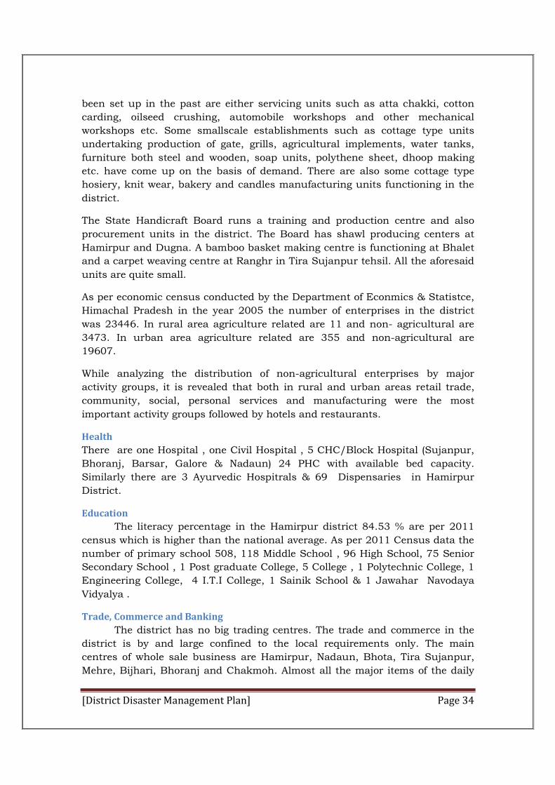
The banking services have a great role in economic growth. The district
has adequate banking facilities, most of the banks are situated at district, tehsil
and block headquarter. During the year 2013-2014, 133 branches of
commercial banks were functioning in the district. The Punjab National Bank is
the lead bank of the district.
Table 2: Bank branches in Hamirpur
Sr. No. Bank Group No. of Branches in District
Deposit (Crores)
Advance Debt‐Deposit Ratio
1. Punjab National bank 35 1799.16 292.86 16.28
2. Allahabad bank 1 40.08 10.15 25.32
3. BOI 1 9.13 2.60 28.48
4. CB 3 74.90 13.21 17.64
5. CBI 4 137.43 25.79 18.77
6. OBC 2 96.32 17.80 18.48
7. SBI 10 678.66 107.54 15.85
8. SBP 8 437.60 83.15 19.00
9. UCO 8 320.10 71.87 22.45
10. UBI 1 8.97 1.80 20.07
11. VB 1 10.27 2.58 25.12
12. SYN 1 11.02 3.48 31.57
13. CORP 1 10.17 5.19 51.03
14. IDBI 1 13.85 2.28 16.46
15. IOB 1 0.70 0.03 4.08
16. Pb& Sindh 1 0.57 0.04 7.02
17. HGB 7 40.25 15.40 38.26
18. ALBB 4 4.94 17.97 100
19. KCCB 40 1250.74 445.25 93.14
20. HDFC 2 30.04 7.64 25.43
21. ICICI 1 19.24 3.73 19.39
Total 133 4994.14 1130.36 22.63
Transport
Road transportation is the life of the economy of the district. In view of
topographical constraints, road are the only means of transportation in the
district. The district is neither linked with air nor with railway line. Therefore,
the entire goods transportation is done by road in the district. The district has a
good number of roads and it is connected by road to the outside areas.The
goods transport is almost in the hands of private truck operators while in case
[District Disaster Management Plan] Page 36
of passenger transport, the buses of various regions are mainly plied. Himachal
Pradesh Road Transport Corporation, HRTC Hamirpur is plying a fleet of 107
buses. Punjab Roadways are also plying buses on various routes in the district.
The district headquarters Hamirpur is linked with the state capital by a bus
route. The main bus routes linking up the district with other states are, namely
Hamirpur-Haridwar, Awahdevi-Delhi, Hamirpur-Amritsar, tira Sujanpur-Delhi,
Hamirpur-Chandigarh and Hamirpur-Manali-Ladakh.
Map 9: Road network of Hamirpur
The state highways Nos. 32 & 39 and national highway nos. 70 & 88 pass
through the district.
During the period 2008-09, total 5101 vehicles were registered in the district.
The following statement shows the number and type of motor vehicles
registered during year, 2008 & 2009.
Gram Panchayats
There is 229 Gram Panchayats (Table 3) in the district by the end of
December, 2011. Each Gram Panchayat consists of one Pradhan, one Up-
Pardhan and five members duly elected by voters of that Gram Panchayat.
Number of members varies according to the population of Gram Panchayat.

[District Disaster Management Plan] Page 37
Map 10: Panchayat map of Hamirpur
Table 3 Block wise number of panchayat
District Hamirpur
Sr. No. Name of Block No. of Panchayats
1. Nadaun 58
2. Sujanpur 20
3. Hamirpur 24
4. Bamson 46
5. Bijhadi 48
6. Bhoranj 33
Total 06 229
[District Disaster Management Plan] Page 38
Chapter-III
Hazard, Risk, Vulnerability and Capacity Analysis
3.1Hazards & Vulnerability In Hamirpur
Hamirpur district is situated at the elevation varies from 400 meters to 1232
meters having the configuration ranging from the almost flat-lands that border
the portion of rivers Beas to the lofty heights of cliffs and precipitous slopes of
hill-ranges. There are three principal ranges which run in a South-Easterly
direction. It is situated at lower elevation and comparatively warmer but has
some hilly ranges covered with Pine forests. It is located between Latitude 31
24’28”-31 53’35” north latitudes and 76 17’50” -76 43’42” east longitudes. It
has a deeply dissected topography, complex geological structure and a rich
temperate flora in the sub-tropical latitudes. Located in Shivalik region,
Hamirpur is highly vulnerable to the natural disasters.Earthquakes, landslides,
cloudbursts, flash floods; forest fires, avalanches etc have caused tremendous
loss to the State. Besides loss of lives, these disasters also resulted into
considerable loss to state exchequer.
Apart from the hazard prone geographical conditions, Hamirpur is also
vulnerable due to the unplanned developments, rapid urbanization, and growth
in the population and temporary settlements in urban areas. Difficult
accessibility in the rural areas along with lack of awareness on disaster risk
reduction and preparedness has also contributed to increase in risk of the
District’s population. As per the Vulnerability Atlas of India, in Himachal
approximate 70percent houses are made of mud, un-burnt brick and stone wall
and as Hamirpur is part of Himachal Pradesh, the condition is not different in
this district. This is a sign of very high vulnerability, considering probability of
Earth quake, Landslides, Flash flood and Cloud burst etc. Beas river flows
through the northern part of and Satluj river flows through the southern part of
district Hamirpur. Both of these two rivers namely Beas and Satluj are the
famous rivers in Himachal Pradesh. The District has a total area of 1,118 sq.
kms, forming 2.01 per cent of the total area of the state. It ranks 12th in area
amongst the Districts of the state.
In the disaster prone map of the country, Himachal Pradesh has attained its
position among first five states in respect of natural hazards, i.e., earthquakes,
flash floods triggered by cloud burst, landslides, avalanches and forest fires,
consequently Hamirpur as part of Himachal Pradesh can be categorized in the
same category. Frequent droughts in summers are also falling in zone (IV) of
seismic belt. These disasters have caused immense loss of property, natural
wealth, and human lives. In addition to the natural causes, various manmade
[District Disaster Management Plan] Page 39
activities have also added the multiplier effect and created the imbalance in
overall ecology of the area. All these factors have combined to turn this state
into a vulnerable state, affected by almost all the types of natural and manmade
disasters.
A brief overview of all these hazards and their potential impact is documented
in the following sections. The disasters, which generally occur in this district,
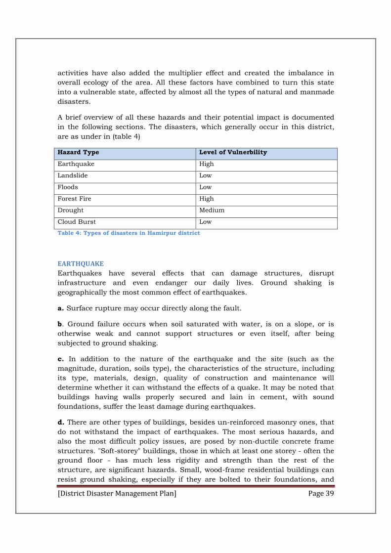
are as under in (table 4)
Hazard Type Level of Vulnerbility
Earthquake High
Landslide Low
Floods Low
Forest Fire High
Drought Medium
Cloud Burst Low
Table 4: Types of disasters in Hamirpur district
EARTHQUAKE
Earthquakes have several effects that can damage structures, disrupt
infrastructure and even endanger our daily lives. Ground shaking is
geographically the most common effect of earthquakes.
a. Surface rupture may occur directly along the fault.
b. Ground failure occurs when soil saturated with water, is on a slope, or is
otherwise weak and cannot support structures or even itself, after being
subjected to ground shaking.
c. In addition to the nature of the earthquake and the site (such as the
magnitude, duration, soils type), the characteristics of the structure, including
its type, materials, design, quality of construction and maintenance will
determine whether it can withstand the effects of a quake. It may be noted that
buildings having walls properly secured and lain in cement, with sound
foundations, suffer the least damage during earthquakes.
d. There are other types of buildings, besides un-reinforced masonry ones, that
do not withstand the impact of earthquakes. The most serious hazards, and
also the most difficult policy issues, are posed by non-ductile concrete frame
structures. "Soft-storey" buildings, those in which at least one storey - often the
ground floor - has much less rigidity and strength than the rest of the
structure, are significant hazards. Small, wood-frame residential buildings can
resist ground shaking, especially if they are bolted to their foundations, and
[District Disaster Management Plan] Page 40
have strong first stories. Most deaths and injuries during earthquakes are
caused by the failure of buildings and structures. The number of casualties also
depends upon the time of occurrence of the earthquake.
e. The impact of earthquakes differs for urban and rural areas, primarily
because of the nature of infrastructure, the quality of housing and occupational
differences. In rural areas, it is primarily the housing and physical structures,
including irrigation infrastructure, which may suffer extensive damage, without
necessarily destroying crops. In the urban areas on the other hand, in addition
to housing and physical infrastructures, it may also disturb the service
infrastructure such as water supply, sewage, telephones, electricity, piped gas
supply etc. which are essentially underground installations and hence exposed
to direct impact.
Located on south western part of Himachal Pradesh, Hamirpur district
lies in the hilly tract covered by the lower Himalayas in Shivalik range It is
situated between 76 17’50” -76 43’42” east longitudes and 31 24’28”-31 53’35”
north latitudes. Although it is a seismic prone area but in the recent past the
district has not witnessed any major earth quake, minor tremors however have
been occurring off and on.
In this district most of the houses are made of mud, un-burnt and stone brick
wall, which can’t resist the shaking of earthquake. In rural areas most of the
construction is un- engineered construction, which is highly vulnerable to
earthquakes. In urban areas the housed have been built in haphazard manner.
The number of multistory buildings is rampantly increasing. All these factors
are contributing in increase of risk.
The Hamirpur district is vulnerable to multi-hazards viz. earthquake, road
accidents. Forest fires, urban fires, floods, landslides, hailstorms, dam burst,
drought, but particularly EARTHQUAKE, as the district falls in the highest
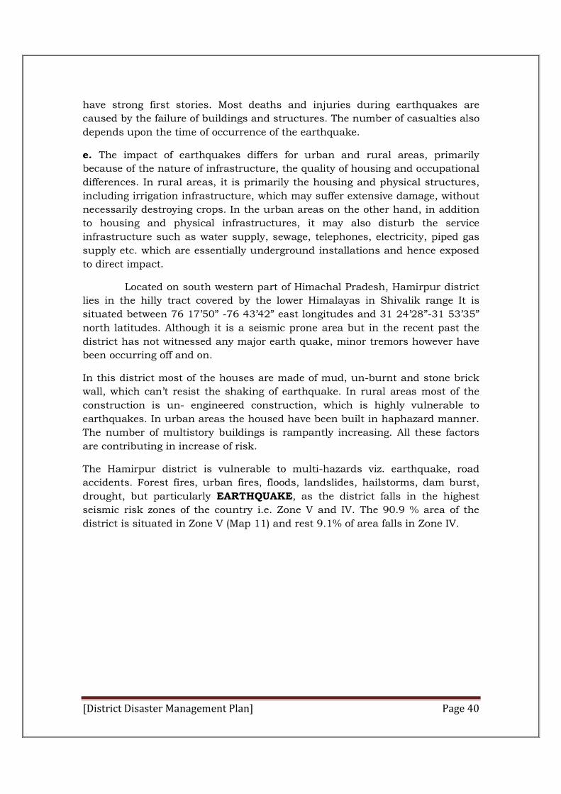
seismic risk zones of the country i.e. Zone V and IV. The 90.9 % area of the
district is situated in Zone V (Map 11) and rest 9.1% of area falls in Zone IV.
[District Disaster Management Plan] Page 41
Map 11: Earth quake hazard map of Hamirpur
The Earthquake Hazard Map shows that 90.9 % area of the Hamirpur district is
situated in Zone V and rest 9.1% of area falls in Zone IV.
Besides loss of lives, these disasters also resulted into considerable loss
to state exchequer. Due to the unplanned developments, rapid urbanization, and
growth in the population and temporary settlements in urban areas increases the
risk of loss due to eathquake hazard. Difficult accessibility in the rural areas along
with lack of awareness on disaster risk reduction and preparedness has also
contributed to increase in risk of the District’s population. As per the Vulnerability
Atlas of India, in Himachal approximate 70 percent houses are made of mud, un-
burnt brick and stone wall and as Hamirpur is part of Himachal Pradesh, the
condition is not different in this district increases the loss due to earthquake
hazard.
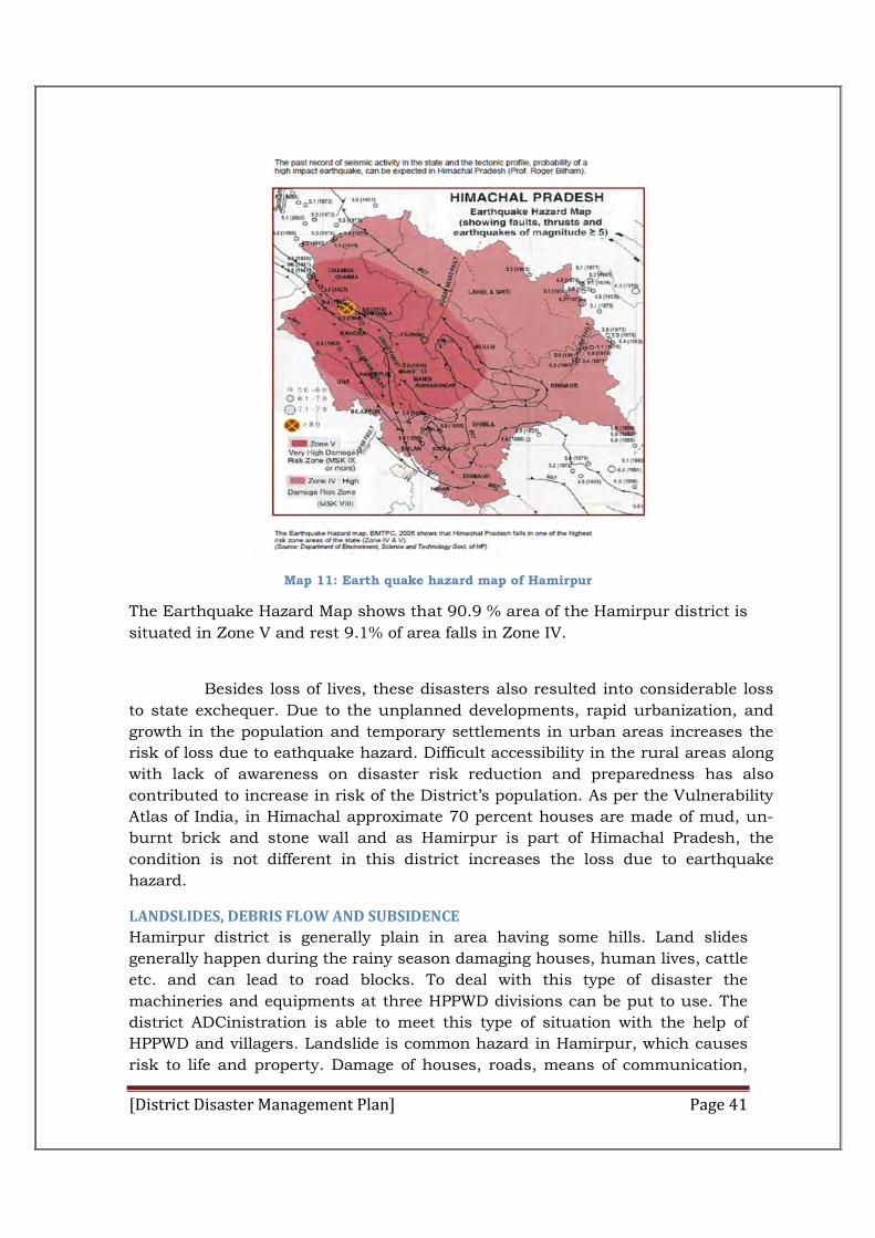
LANDSLIDES, DEBRIS FLOW AND SUBSIDENCE
Hamirpur district is generally plain in area having some hills. Land slides
generally happen during the rainy season damaging houses, human lives, cattle
etc. and can lead to road blocks. To deal with this type of disaster the
machineries and equipments at three HPPWD divisions can be put to use. The
district ADCinistration is able to meet this type of situation with the help of
HPPWD and villagers. Landslide is common hazard in Hamirpur, which causes
risk to life and property. Damage of houses, roads, means of communication,
[District Disaster Management Plan] Page 42
agricultural land, are some of the major consequences of landslides. The fragile
nature of rocks forming the mountains, along with the climatic conditions and
various anthropogenic activities has made the district vulnerable to the
Landslides. The vulnerability of the geologically young, unstable and fragile
rocks has increased many times in the recent past due to various unscientific
developmental activities. Deforestation, unscientific road construction, terracing
and water intensive agricultural practices, encroachment on steep hill slopes
are the anthropogenic activities, which have increased the intensity and
frequency of landslides. Man induced unplanned construction activities are very
much responsible for landslides. Unscientific land use pattern is the major
cause for the deteriorating situation. Experts point out that unplanned
expansion of town is overloading and destabilising slopes. Overloaded slopes
may initially cause minor landslides , but in later stage these could trigger
larger landslide.
Map 12: Landslide hazard map of Hamirpur
Source: Himachal Pradesh Vulnerability Atlas
DROUGHT:
Drought is a period of time without substantial rainfall that persists from one year
to the next. Drought is a normal part of virtually all climatic regions, including
areas with high and low average rainfall. Drought is the consequence of anticipated
natural precipitation reduction over an extended period of time, usually a season
or more in length. Droughts can be classified as meteorological, hydrologic,
agricultural, and socioeconomic. (Table ) presents definitions for these different
[District Disaster Management Plan] Page 43
types of drought. Droughts are one of the most complex of all natural hazards as it
is difficult to determine their precise beginning or end. In addition, droughts can
lead to other hazards such as extreme heat and wildfires. Their impact on wildlife
and area farming is enormous, often killing crops, grazing land, edible plants and
even in severe cases, trees. A secondary hazard to drought is wildfire because dying
vegetation serves as a prime ignition source. Therefore, a heat wave combined with
a drought is a very dangerous situation.
Drought is the major problem of the district. The sources of drinking
water as well as nalla etc. dry-up during the months of summer, due to depleted
ground water level and insufficient rainfall. This problem is being faced in Bamson,
Bhoranj, Hamirpur, Bijhari and some parts of Nadaun and Sujanpur blocks. The
district ADCinistration is combating this problem by deploying drinking water
tankers, installation of deep water hand-pumps and reviving the traditional water
sources.
Table 5: Drought classification table
Drought type Definition
METEOROLOGICAL DROUGHT
The degree of dryness or departure of actual precipitation from an expected average or normal amount based on monthly, seasonal, or annual time scales.
HYDROLOGICAL DROUGHT The effects of precipitation shortfalls on stream flows and reservoir, lake, and groundwater levels.
AGRICULTURAL DROUGHT Soil moisture deficiencies relative to water demands of plant life, usually crops
Drought impacts (Table ) large areas and crosses jurisdictional boundaries. All
existing and future buildings, facilities and populations are exposed to this
hazard and could potentially be impacted. However, drought impacts are mostly
experienced in water shortages and crop/livestock losses on agricultural lands
and typically have no impact on buildings. The economic impact of droughts
can be significant as they produce a complex web of impacts that spans many
sectors of the economy and reach well beyond the area experiencing physical
drought. This complexity exists because water is integral to our ability to
produce goods and provide services. If droughts extend over a number of years,
the direct and indirect economic impact can be significant.
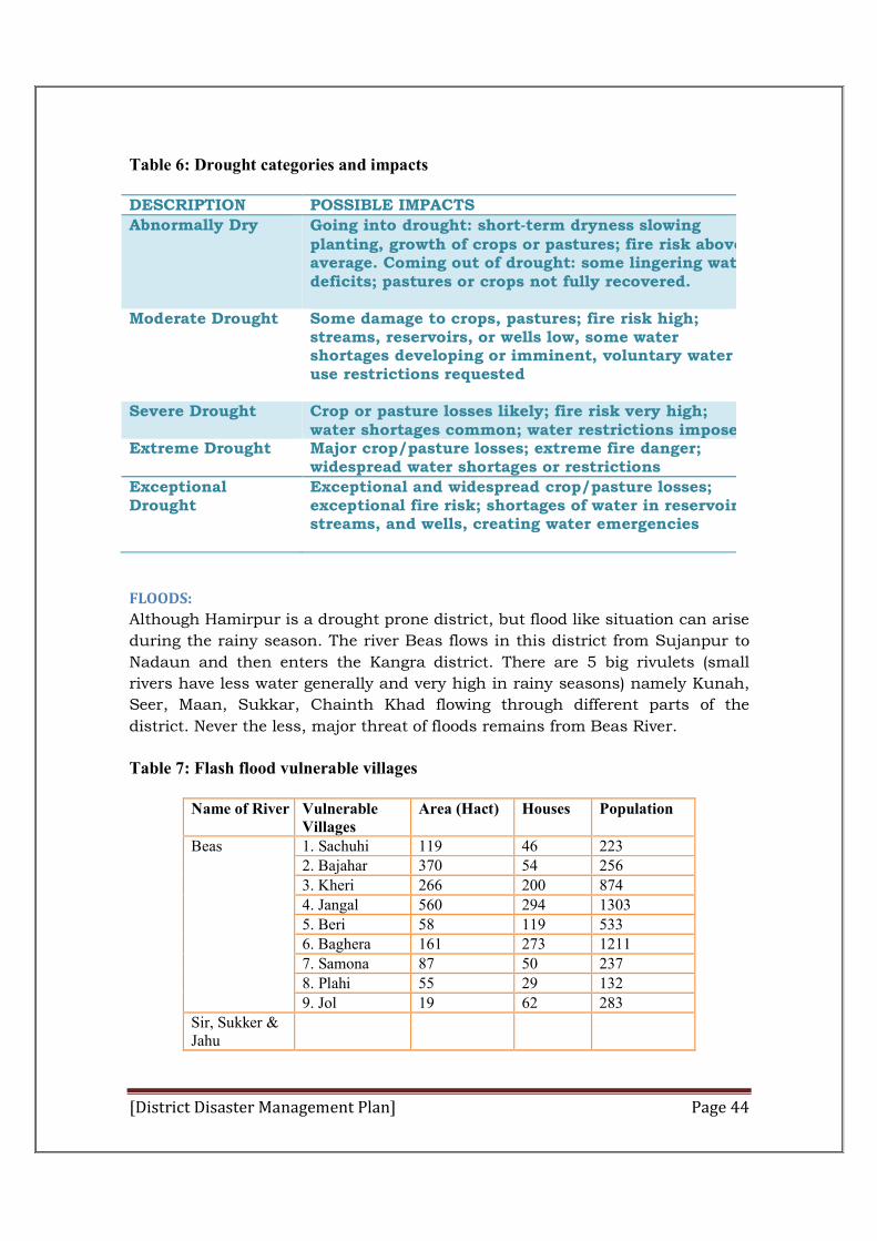
[District Disaster Management Plan] Page 44
Table 6: Drought categories and impacts
DESCRIPTION POSSIBLE IMPACTS
Abnormally Dry Going into drought: short‐term dryness slowing planting, growth of crops or pastures; fire risk above average. Coming out of drought: some lingering water deficits; pastures or crops not fully recovered.
Moderate Drought Some damage to crops, pastures; fire risk high; streams, reservoirs, or wells low, some water shortages developing or imminent, voluntary water use restrictions requested
Severe Drought
Crop or pasture losses likely; fire risk very high; water shortages common; water restrictions imposed
Extreme Drought Major crop/pasture losses; extreme fire danger; widespread water shortages or restrictions
Exceptional Drought
Exceptional and widespread crop/pasture losses; exceptional fire risk; shortages of water in reservoirs, streams, and wells, creating water emergencies
FLOODS:
Although Hamirpur is a drought prone district, but flood like situation can arise
during the rainy season. The river Beas flows in this district from Sujanpur to
Nadaun and then enters the Kangra district. There are 5 big rivulets (small
rivers have less water generally and very high in rainy seasons) namely Kunah,
Seer, Maan, Sukkar, Chainth Khad flowing through different parts of the
district. Never the less, major threat of floods remains from Beas River.
Table 7: Flash flood vulnerable villages
Name of River Vulnerable Villages
Area (Hact) Houses Population
Beas 1. Sachuhi 119 46 223 2. Bajahar 370 54 256 3. Kheri 266 200 874 4. Jangal 560 294 1303 5. Beri 58 119 533 6. Baghera 161 273 1211 7. Samona 87 50 237 8. Plahi 55 29 132 9. Jol 19 62 283
Sir, Sukker & Jahu
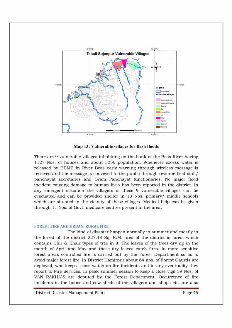
[District Disaster Management Plan] Page 45
Map 13: Vulnerable villages for flash floods
There are 9 vulnerable villages inhabiting on the bank of the Beas River having
1127 Nos. of houses and about 5050 population. Whenever excess water is
released by BBMB in River Beas early warning through wireless message is
received and the message is conveyed to the public through revenue field staff/
panchayat secretaries and Gram Panchayat functionaries. No major flood
incident causing damage to human lives has been reported in the district. In
any emergent situation the villagers of these 9 vulnerable villages can be
evacuated and can be provided shelter in 13 Nos. primary/ middle schools
which are situated in the vicinity of these villages. Medical help can be given
through 11 Nos. of Govt. medicare centres present in the area.
FOREST FIRE AND URBAN, RURAL FIRE:
The kind of disaster happen normally in summer and mostly in
the forest of the district 227.48 Sq. K.M. area of the district is forest which
contains Chir & Khair types of tree in it. The leaves of the trees dry up in the
month of April and May and these dry leaves catch fires. In more sensitive
forest areas controlled fire is carried out by the Forest Department so as to
avoid major forest fire. In District Hamirpur about 64 nos. of Forest Gaurds are
deployed, who keep a close watch on fire incidents and in any eventuality they
report to Fire Services. In peak summer season to keep a close vigil 59 Nos. of
VAN RAKHA`S are deputed by the Forest Department. Occurrence of fire
incidents in the house and cow sheds of the villagers and shops etc. are also

[District Disaster Management Plan] Page 46
reported in the district. The major fire incident which occurred in the district
was at Nadaun on 23rd
July, 05 where a shop caught fire damaging property
worth 10.00 lakhs; with the timely help Fire Brigade property worth 30.00
lakhs was saved.
Map 14: Forest Fire hazard map of Hamirpur
Source: Himachal Pradesh Vulnerability Atlas
Road Traffic Injuries and Deaths
In a 2005 report by the World Health Organization (WHO), injury was described
as “one of the leading causes of mortality and morbidity worldwide.” More
specifically, road traffic injuries were identified as the second leading cause of
death worldwide for people aged 5-14 years, the leading cause of death for those
aged 15-29 years, and the third leading cause for people aged 30-44 years.
What is particularly concerning about these statistics is the fact the 15-44 year-
old age group also represents the most economically productive age group of
any society
In light of increased motorization, industrialization, and rapid economic growth
– it can be reasonably expected that the incidence of road traffic injuries will
likewise increase. In 1996, WHO projected that injuries would be the first or
second leading cause of healthy years of life lost worldwide by 2020 – an
increase of 109% from 1990, surpassed only by cancer – and the fifth leading
cause of death for all ages combined by 2030.
The consequences of these increases have the potential to overwhelm low- and
middle-income countries (LMICs) in particular. As it stands now, in the case of
[District Disaster Management Plan] Page 47
road traffic injuries, which account for one quarter of all injury-related deaths,
LMICs suffer over 90% of the word’s road fatalities while owning less than 50%
of the world’s registered vehicles. Furthermore, the majority of road traffic
injury victims are not vehicle drivers, but rather pedestrians and vehicle
passengers, implying a vulnerability to traffic-related injuries regardless of
ownership. A clearer example of this disparity can be found in India, which has
“1% of the motor vehicles in the world, but bears the burden of 6% of the global
vehicular accidents.”
Nonetheless, the effects of injury go beyond fatalities alone; after all, not every
injury results in death. Both temporary and permanent disability can have
equally significant consequences on individuals, families, and their
communities – loss of income due to disability can extend beyond the victim
when family members have to leave work to stay at home and provide care for
the victim, as well as subsequent losses in productivity within the local work
force.
3.2 Risk Identification:
As previously seen in the previous section, the Hamirpur district is highly
vulnerable to various natural disasters. This coupled with a multiple of other
factors like limited awareness on disaster risk reduction and preparedness and
improper planning have contributed to increase in risk to the people. It is
certainly possible to reduce the potential impact of disasters by evolving
appropriate preparedness, preventive and response plans. Risk identification
and assessment constitutes the first step in developing the District plan.Every
care has been taken to provide accurate information in the atlas to draw a
realistic picture of the pertinent and latent risks. Any discrepancy present in
the Atlas can be attributed to limited access to the available data. This
document can be further refined by adding more information from the available
resources and taking into account the dynamic nature of risks.
3.3 Overall Vulnerability of District Hamirpur: Overall Vulnerability of district Hamirpur on the basis of above analysis and
according to the figure that compiled below by the H.P state cuncil of science &
Technology shows that Hamirpur district to be moderately vulnerable to hazard
suspetability.
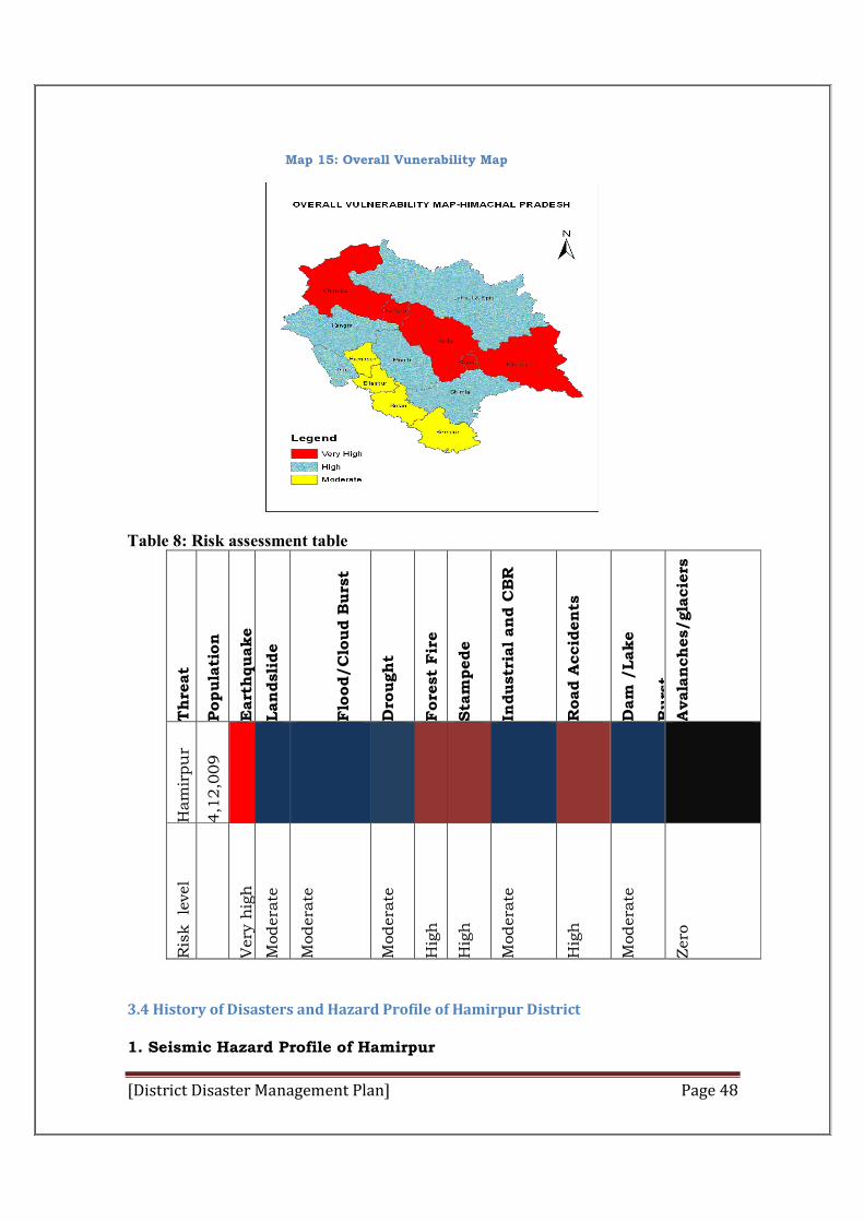
[District Disaster Management Plan] Page 48
Map 15: Overall Vunerability Map
Table 8: Risk assessment table
Th
reat
Popula
tion
Eart
hquake
Lan
dsli
de
Flo
od/C
loud B
urs
t
Dro
ugh
t
Fore
st
Fir
e
Sta
mpede
Industr
ial an
d C
BR
Road A
ccid
en
ts
Dam
/Lake
Burs
t A
vala
nch
es/gla
cie
rs
Ham
irpu
r
4,1
2,0
09
Ris
k
level
Very
hig
h
Modera
te
Modera
te
Modera
te
Hig
h
Hig
h
Modera
te
Hig
h
Modera
te
Zero
3.4 History of Disasters and Hazard Profile of Hamirpur District
1. Seismic Hazard Profile of Hamirpur
[District Disaster Management Plan] Page 49
Hamirpur was the part of KANGRA district until 1st September 1971.
Date Locations affected Magnitude /
Intensity
Damage
4th April, 1905 Hamirpur, Kangra Magnitude 8.0 Approx. 19,800
people died
Table 9: Districts of Himachal Pradesh with Seismic Intensities
Sr. No. Name of District S e i s m i c Zones Intensity MSK IX or
more % Area
MSK VIII % area
1. Kangra V/IV 98.6 1.4
2. Mandi V/IV 97.4 2.6
3. Hamirpur V/IV 90.9 9.1
4. Chamba V/IV 63.2 36.8
5. Kullu V/IV 53.1 46.9
6. Una V/IV 37.0 63.0
7. Bilaspur V/IV 25.3 74.7
8. Solan V/IV 2.4 97.6
9. Lahaul & Spiti V/IV 1.1 98.9
10. Bilaspur V/IV --- 100
11. Shimla V/IV --- 100
12. Sirmour V/IV --- 100
2. Landslide Vulnerable areas in Hamirpur (in square kilometres)
The regions around the Kakker Sub division, 3.0 to 3/300 kms near village Palahi
Sujanpur Bagehra Sandhol road, and 17 to 18 kms near village Bajahar Sujanpur
Bagehra Sandhol road and 3.0 to 3/800 km area near village Bereda kakker
Sachuhi road are identified as the sliding prone areas of Hamirpur.
As per BMTPC, Landslide Hazard Zonation Atlas of India, a total of 851 sq. km of
Hamirpur district fall under high landslide vulnerable area, 204 sq. km area fall
Severe to very high 0
High 851 Moderate to low 204
Unlikely 45
Total area(Approx.) 1100
[District Disaster Management Plan] Page 50
under moderate to low lanslide vulnerable area out of total area of about 1100 sq
kms.
3. Flood Hazard of the District Hamirpur
On 13th Aug, night due to heavy rainfall causing flood in Sear Khadd, due to this
Jahu Valley Bridge broke down and in this incident 3 local people of hamirpur
district washed away and lost their lives.
4. Road traffic injuries and deaths
The highly mountainous terrain of district also results in many road accidents. With the increasing number of vehicles the cases of road accidents are also increasing. The history of road accidents is given in the following table:
Table 10: Road traffic injuries and deaths in Hamirpur
Year Incidents No. of deaths Injured Vehicles involved
2005 176 45 252 249
2006 148 27 317 189
2007 146 27 251 164
2008 134 27 226 172
2009 143 38 210 197
2010 159 27 270 226
2011 126 31 220 165 2012 128 35 334 168
2013 151 54 209 211
2014upto 31.07.2014
90 15 287 125
[District Disaster Management Plan] Page 51
Chapter-IV
Institutional Mechanism
4.1 Institutional Mechanism:
PREMISE
The District ADCinistration has principal responsibility for natural,
technological, human induced and biological emergency preparedness,
response, relief and rehabilitation, yet other departments has also shared
responsibility with respect to any grave or imminent danger which can cause
loss to life and property.
Disasters could, individually or in combination, cause a grave emergency
condition in any area of the district. It can differ in scope and intensity, from a
small local incident with minimal damage to a multi-district disaster with
extensive loss of life and collateral damage.
The actions of prevention, preparedness, mitigation and response and
recovery operations are conducted by the District ADCinistration. Local
authorities will exhaust their resources, and then use resources of other
support agencies volunteer groups, the private sector, community, and/or
neighboring districts.
State assistance will supplement District ADCinistration efforts, if it is
clearly demonstrated that it is beyond the local capability to fend the disaster
situation.
District Disaster Management Authority
The District Disaster Management Authority (DDMA) will act as the district
planning; coordinating and monitoring body in accordance with the guidelines
lay down by the State Authority.
As per Section 25 of the DM Act 05, A DDMA for Hamirpur district has also
been constituted, consisting of the following members:
S.No. Officials Designation
DDMA
1. Deputy Commissioner Chairperson 2. Superintendent of Police Member 3. Chief Medical Officer Member 4. Superintending engineer (PWD) Member 5. Superintending Engineer (I & PH) Member 6. Superintending Engineer (MPP & P) Member 6. Chairperson of the Zila Parishad Member 7. Additional District Magistrate Member
[District Disaster Management Plan] Page 52
DDMA
The roles and responsibilities of the DDMA
The roles and responsibilities of the DDMA have been elaborated in Section 30 of
the DM Act, 2005. The DDMA will act as the planning, coordinating and
implementing body for DM at the District level and take all necessary measures for
the purposes of DM in accordance with the guidelines laid down by the NDMA and
SDMA. It will, inter alia prepare the District DM plan for the District and monitor
the implementation of the National Policy, the State Policy, the National Plan, the
State Plan and the District Plan. The DDMA will also ensure that the guidelines for
prevention, mitigation, preparedness and response measures lay down by the
NDMA and the SDMA are followed by all the Departments of the State Government
at the District level and the local authorities in the District. The DDMA will further
ensure that the areas in the district vulnerable to disasters are identified and
measures for the prevention of disasters and the mitigation of its effects are taken,
ensure that the guidelines for prevention of disasters, mitigation of its effects,
preparedness and response measures as laid down by the National Authority and
the State Authority are followed by all departments, lay down guidelines for
prevention of disaster management plans by the department of the Government at
the districts level and local authorities in the district, monitor the implementation
of disaster management plans prepared by the Departments of the Government at
the district level, lay down guidelines to be followed by the Departments of the
Government at the district level for purposes of integration of measures for
prevention of disasters and mitigation in their development plans and projects and
monitor the implementation of the same, review the state of capabilities and
[District Disaster Management Plan] Page 53
preparedness level for responding to any disaster or threatening disaster situation
at the district level and take steps for their up gradation as may be necessary,
organise and coordinate specialised training programmes for different levels of
officers, employees and voluntary rescue workers in the district, facilitate
community training and awareness programmes for prevention of disaster or
mitigation with the support of local authorities, governmental and non-
governmental organisations, setup, maintain, review and upgrade the mechanism
for early warnings and dissemination of proper information to public, prepare,
review and update district level response plan and guidelines. The DDMA will also
coordinate response to any threatening disaster situation or disaster, coordinate
with, and provide necessary technical assistance or give advice to the local
authorities in the district for carrying out their functions, examine the construction
in any area in the district and issue direction the concerned authority to take such
action as may be necessary to secure compliance of such standards as may be
required for the area, and identify buildings and places which could, in the event of
any threatening disaster situation or disaster, be used as relief centres or camps
and make arrangements for water supply and sanitation in such buildings or
places, establish stockpiles of relief and rescue materials or ensure preparedness
to make such materials available at as or notice. The DDMA will encourage the
involvement of non- governmental organisations and voluntary social-welfare
institutions working at the grassroots level in the district for disaster management
ensure communication systems are in order, and disaster management drills are
carried out periodically. An effective disaster management strategy must be
supported by a quick decision making process which will include the issues related
to warning, conduct evacuation and rescue & relief operations in the event of a
disaster. This requires a core team of senior decisionmaker shaving ADCinistrative
control over the key resource organisations. Therefore,it is utmost need to
constitute a DCG (District Crisis Group) with District Deputy Commissioner as its
leader. The organisational structure for disaster management in the district has
been proposed here, which recommends the District Magistrate as the nodal officer
for control and co-ordination of emergency activities.
DISTRICT DISASTER MANAGEMENT AUTHORITY
This authority has been constituted under section 25 (1) of the Disaster
Management Act 2005 under the chairmanship of District collector i.e. Deputy
Commissioner with the following officers as its members:-
1) Superintendent of Police
2) Chief Medical Officer
3) Superintending Engineer (PWD)
4) Superintending Engineer (IPH)
[District Disaster Management Plan] Page 54
5) Superintending Engineer (MPP &Power)
6) Chairperson Zila Parishad
7) Additional District Collector/Additional Deputy Commissioner (Protocol) as Chief
Executive Officer of the Authority.
POWERS AND FUNCTIONS OF DISTRICT AUTHORITY
As per section 30 of the Disaster management Act 2005, this authority has
been vested with the following powers and functions:-
1) It shall act as the planning, coordinating and implementing body in the district
for disaster management and take all measures for disaster management in the
district as per the guidelines in the National/state Disaster management plans
2) To prepare the District Disaster management Plan of the district and its periodic
review and update.
3) To identify the areas vulnerable to the different hazards in the district and
measures for its prevention, mitigation thereof by the different departments and
the local authorities at the district level.
4) Give direction to the different departments and the local authorities to take
measures for prevention and mitigation of the disasters in the district.
5) Monitor the implementation of the disaster management plans prepared by the
departments at the district level.
District Disaster Management Advisory Committee
District level Disaster Management Advisory Committee(s) has been appointed by
the District Disaster Management Authority (DDMA) to take advice on various
subject specific fields within the overall context of disaster management.
Sl No Appointment/Name Designation in the Committee
1. Deputy Commissioner, Chairman 2. Chairman ZP, Co-Chairman 3. Superintendent of Police, Member 4. Additional DM, Member Secretary 5. District Revenue Officer, Member 6. SDM,Hamirpur,Member 7. Chief Medical Officer, Member 8. Superintending Engineer PWD, Member 9. Superintending Engineer I&PH, Member 10. Superintending Engineer HPSEB, Member 11. District Food and Supplies Controller, Member 12. Commandant Home Guards, Member
[District Disaster Management Plan] Page 55
13. Fire Officer, Member 14. District Public Relations Officer, Member 15. GM Telecommunications, Member 16. Divisional Forest Officer, Member 17. Dy Director Animal Health & Breeding, Member 18. Executive Officer, Municipal Council Hamirpur, Member
Non Official Members
Prof.Prem Kumar Dhumal (Honble MLA) Sh Ishwar Dass Dhiman (Honble MLA) Sh. Inder Dutt Lakhanpal (Honble MLA) Sh Vijay Agnihotri (Honble MLA) Sh Narender Thakur (Honble MLA)
Organization and Responsibility
The Deputy Commissioner Hamirpur (Chairperson DDMA) has the
overall responsibility for disaster management in the District. In case of
emergency situation the Incident Commander activates the Incident Command
System (ICS). On activation of the ICS, based on the emergency situation the
relevant Emergency Support Functions (ESFs) will be utilized.
Since this District Disaster Management Plan (DDMP) is concerned with
the many hazards to which the district and the citizens may be exposed before,
during and after a disaster occurs, responsible authorities operate in
accordance with the six phases of disaster management:
1. Prevention – Preventive actions may include the inquisitiveness about intelligence and other information to a range of activities that may include deterrence, heightened security for potential targets, investigations to determine the nature and source of the threat, public health surveillance and testing, disrupting illegal activities etc.
2. Preparedness – Actions may be taken to eliminate or reduce the impact
of a disaster. Such measures include zoning and land-use measures, formulating and enforcing building codes, public education about hazards and protective measures, hazard and vulnerability analysis (hrva) and preventative health care.
3. Mitigation – It includes moderation of (a quality or condition) in force or
intensity. Any cost-effective action taken to eliminate or reduce the short-term risk to life and property from natural and technological hazards is called mitigation. These actions are taken over the short-term to return vital life support systems to minimum standards. Actions may be taken in advance of a disaster to develop operational capabilities and help
[District Disaster Management Plan] Page 56
communities respond to and recover from a disaster. Such measures include undertaking theCommunity Based Disaster Preparedness Management(CBDM), construction and equipping of EOC’s with warning and communications systems, recruitment, and training of emergency management personnel, development of plans, procedures, arrangements, and agreements, and mock exercises of personnel and systems.
4. Response – Response actions are taken before, during, or after a disaster
/disaster to save lives, minimize damages and enhance recovery operations. Such measures include activation of: Emergency operation centers/ control room, plans and procedures, arrangements and agreements, the emergency alert system, public warning, notification of public officials, provision of mass care, shelter, search and rescue, and security.
5. Recovery and Reconstruction – These are long-term actions to return
life to normal or improved levels. Such measures include damage assessment, assessment of plans, procedures, arrangements, and agreements, and the development of economic impact studies and methods. Reconstructionrefers to the full restoration of all services, and local infrastructure, replacement of damaged physical structures, the revitalization of economy and the restoration of social and cultural life. Reconstruction must be fully integrated into long-term development plans, taking into account future disaster risks and possibilities to reduce such risks by incorporating appropriate measures. Damaged structures and services may not necessarily be restored in their previous form or location. It may include the replacement of any temporary arrangements established as part of emergency response or rehabilitation.
SUB-DIVISIONAL LEVEL DISASTER MANAGEMENT COMMITTEE:
At Sub-Divisional Headquarters, such a committee is chaired by the Sub-
Divisional Magistrate. The constitution of Sub-Divisional Level Committee is as
under:
1. Sub-Divisional Magistrate …………………………… Chairman
2. Deputy Superintendent of Police Member
3. Block Medical Officer. Member
4. President, Nagar Panchayat concerned. Member
5. President, Block Development Committee. Member
6. Executive Engineer, HPPWD. Member
7. Executive Engineer, HPSEB. Member
[District Disaster Management Plan] Page 57
8. Executive Engineer, I & PH. Member.
9. Forest Officer. Member
10. Inspector, Food & Supplies. Member
11. Regional Manager, HRTC. Member
12. Platoon Commander, Home Guards. Member
13. Block Development Officer(S) Member.
14. In-charge, Fire Station. Member
15. Assistant Public Relations Officer. Member
16. Divisional Engineer, Telecommunication. Member
17. Tehsildar ………………………………… Member Secretary.
NON-OFFICIAL MEMBERS:
I. The voluntary bodies (NGOs) at Tehsil/Sub-Divisional Level shall also be
associated.
II. Elected representatives of the area and a few prominent citizens.
TEHSIL LEVEL DISASTER MANAGEMENT COMMITTEE:
At Tehsil Headquarters, such a committee is chaired by the Tehsildar. The
constitution of Tehsil Level Committee is as under:
1. Tehsildar………………………………………………. Chairman
2. Medical Officer Incharge, Dispensary. Member
3. Pradhans, Gram Panchayat. Member
4. Station House Officer. Member
5. Assistant Engineer, I& PH Member
6. Assistant Engineer, PWD Member
7. Assistant Engineer, HPSEB Member

[District Disaster Management Plan] Page 58
8. Inspector, Food & Supplies. Member
9. Home Guards Platoon Commander Member
10. S.E.B.P.O. Member
11. Range Forest Officer. Member
12. Incharge, Fire Station. Member
13. Sub-Division Officer, Telecom. Member
14. Naib Tehsildar (Office Kanungo) ………… Member Secretary
NON-OFFICIAL MEMBERS:
I. The voluntary bodies (NGOs) at Tehsil/Block Level shall also be associated. III. Elected representatives of the area and a few prominent citizens.
BLOCK LEVEL DISASTER MANAGEMENT COMMITTEE:
At Block Headquarters, such a committee is chaired by the Block Development
Officer. The constitution of Block Level Committee is as under:
1. Block Development Officer…………………………. Chairman
2. Medical Officer In-charge, Dispensary. Member
3. Pradhans, Gram Panchayat. Member
4. Station House Officer. Member
5. Assistant Engineer, I& PH Member
6. Assistant Engineer, PWD Member
7. Assistant Engineer, HPSEB Member
8. Inspector, Food & Supplies. Member
9. Home Guards Platoon Commander Member
10. Range Forest Officer. Member
11. In-charge, Fire Station. Member
12. Junior Engineer, Telecom (JTO). Member
[District Disaster Management Plan] Page 59
13. S.E.B.P.O. ……………………….………… Member Secretary
NON-OFFICIAL MEMBERS : I. The voluntary bodies (NGOs) at Block Level shall also be associated. II. Elected representatives of the area a few prominent citizens.
SUB-TEHSIL LEVEL DISASTER MANAGEMENT COMMITTEE:
At Sub-Tehsil Headquarters, such a committee is chaired by the Naib Tehsildar.
The constitution of Sub-Tehsil Level Committee is as under:
1. Naib Tehsildar ………..……………………………… Chairman
2. Medical Officer In-charge, Dispensary. Member
3. Pradhans, Gram Panchayat. Member
4. Station House Officer. Member
5. Assistant Engineer, I& PH Member
6. Assistant Engineer, PWD Member
7. Assistant Engineer, HPSEB Member
8. Inspector, Food & Supplies. Member
9. Home Guards Platoon Commander Member
10. Range Forest Officer. Member
11. In-charge, Fire Station. Member
12. Junior Telecom Officer (J.T.O.). Member
13. S.E.B.P.O. ……………………….………… Member Secretary
NON-OFFICIAL MEMBERS:
I. The voluntary bodies (NGOs) at Sub-Tehsil Level shall also be associated. II. Elected representatives of the areas and a few prominent citizens. The constitution of Kanungo Level Committee will be as under:
1. Field Kanungo ……………………………………. Coordinator.
[District Disaster Management Plan] Page 60
2. Patwaris concerned in Field Kanungo Circle. Member.
3. Pradhan, Gram Panchayat concerned. Member.
4. Junior Engineers of various Govt. establishments. Member.
5. Forest Guards of Forest Department. Member.
6. Telecom Technician Member.
7. Gram Panchayat Vikas Adhikari……………. Member Secretary.
NON-OFFICIAL MEMBERS:
I. All voluntary bodies such as Mahila Mandals, Yuvak Mandals may be associated in management of disasters. II. Elected representatives of the areas and a few prominent citizens.
Gram Panchayat/Village Disaster Management Committee
Subject to the directions of the District Authority, the Gram Panchayat Disaster
Management committees will be responsible for the development and implementation of
GP level disaster management plans.
DISTRICT DISASTER MANAGEMENT AUTHORITY (DDMA), HAMIRPUR
In addition to the District Incident Command Team (DICT), there will be four
Sub divisional levels Incident Command Teams (SICTs) which can be deployed
at the site of a complex emergency/disaster. As and when required, these SICTs
will be deployed at the site of an emergency/disaster for on-scene management.
The teams will focus on the operational aspects of response management, duly
supported by other functions in ICS, e.g. Planning, Logistics, Finance / ADCn, etc.
The District-level Incident Command Team core management structure Shown in
Fig.15
[District Disaster Management Plan] Page 61
CBDM - COMMUNITY BASED DISASTER MANAGEMENT
IRT - INCIDENT RESPONSE TEAM
DISTRICT ADMINISTRATION
At the District level, DDMAs will act as the District planning, coordinating and
implementing body for disaster management and will take all measures for the
purposes of disaster management in the District in accordance with the guidelines
laid down by NDMA and SDMA or the SEC.
Tehsil/Subtehsil/Block/I
RT Disaster Management
Committee
Kango level/PRI/ Edu.
Institution IRT (EOC)
Village Level Committee
CBDM (EOC)
Subdivision Disaster
Management Committee
/Subdivision Incident
command Team (SICT)
(SDM)
Subdivision
Emergency Operation
Centre (EOC)
Teh/Subteh
/ Block EOC
INCIDENT COMMANDER (ADC)
DISTT INCIDENT COMMAND TEAM
District DM
Advisory Committee
DEPUTY COMMISSIONER
CUM
CHAIRMAN DDMA
District
Emergency
Operation Centre
[District Disaster Management Plan] Page 62
4.2 OTHER INSTITUTIONAL ARRANGEMENTS
Armed Forces
Conceptually, the Armed Forces are called upon to assist the civil ADCinistration
only when the situation is beyond their coping capability. In practice, however, the
Armed Forces for man important part of the Government’s response capacity and
are immediate responders in all serious disaster situations. On account of their
vast potential to meet any adverse challenge, speed of operational response and the
resources and capabilities at their disposal, the Armed Forces have historically
played a major role in emergency support functions. These include communication,
search and rescue operations, health and medical facilities, and transportation,
especially in the immediate aftermath of a disaster. Airlift, heli-lift and movement
of assistance to neighbouring countries primarily fall within the expertise and
domain of the Armed Forces. The Armed Forces will participate in imparting
training to trainers and DM managers, especially in CBRN aspects, heli- insertion,
highaltitude rescue, waterman ship and training of paramedics. At the National
level, the Chief of the Integrated Defence Staff to the Chairman Chiefs of Staff
Committee has already been included in the NEC. Similarly, at the District level,
the local representatives of the Armed Forces will be opted in the DDMA meetings
to ensure closer coordination and cohesion.
Central Paramilitary Forces
The Central Paramilitary Forces (CPMFs), which are also the Armed Forces of the
Union, play a key role at the time of immediate response to disasters. Besides
contributing to the NDRF, they respond to disasters which may occur in the areas
where they are posted. The local representatives of the CPMFs located in the
district Kullu will be co- opted/invited in the DDMA meeting for better
coordination.
State Police Forces and India Reserve Battalions
The State Police Forces and the India Reserve Battalions are crucial for immediate
response to disasters. The existing Police Forces located in the district will be
trained in advanced SAR and MFA techniques so that their services can be utilised
in disaster situations/events. Fire Services and
Home Guard
The Home Guards and Fire Services will be assigned an effective role in the field of
disaster management. They will be deployed for community preparedness, conduct
of mock drill and public awareness. A culture of voluntary reporting to duty
stations in the event of any disaster will be promoted. The Fire Services upgraded
to acquire multihazard rescue capability. The existing set up of these services
would be strengthened to take up the new role more effectively. NCC, NSS, NYKS,
[District Disaster Management Plan] Page 63
Scouts and Guides, Mahilla and Yuvak Mandals as organisations would be roped
in DM. They will be trained in search and rescue (SAR) and medical first aid (MFA)
and other aspects of Disaster Management as per the need. The potential of these
organisations would also be used for education and awareness generation in
Disaster Management. A database of trained personnel would be created and
uploaded regularly in the DDMA website.
4.3 DISTRICT EMERGENCY OPERATION CENTRE (DEOC)
District ADCinistration shall set up District Emergency Operation Centre
and provide adequate manpower for manning them on 24x7 basis round the year
and arrange training for the EOC Staff on EOC operations. District ADCinistration
shall develop SOP/ Protocol for activation of DEOCs during emergency/disasters.
The DEOC would perform the following functions:-
i. District control room would be the nerve centre for the disaster management;
ii. To monitor, coordinate and implement the actions for disaster management;
iii. Activate the ESF in the event of a disaster and coordinate the actions of various
departments/ agencies;
iv. Ensure that all warning, communication systems and instruments are in
working conditions;
v. Receive information on a routine basis from the district departments on the
vulnerability of the various places and villages (parts of the districts);
vi. Receive reports on the preparedness of the district level departments and the
resources at their disposal to arrange and meet their requirements;
vii. Upgrade the Disaster Management Action according to the changing scenario;
viii. Maintain a web-based inventory of all resources through the India Disaster
Resource Network (IDRN);
ix. Provide information to the Relief Commissioner’ Office of the disaster
/emergencies /accidents taking place in the district regularly and maintain a data
base of disasters and losses caused by them;
x. Monitor preparedness measures and training activities;
xi. Providing information at district level, local level and to disaster prone areas
through appropriate media;
xii. Brief the media of the situations and prepare day to day reports during the
disasters;
[District Disaster Management Plan] Page 64
xiii. To report the actual scenario and the action taken by the District
ADCinistration;
xiv. Maintain a data base of trained personnel and volunteers who could be
contacted at any time; xv. Lease with on-site operation centre, State EOC and other
emergency services
The Additional District Magistrate shall be the Nodal Officer for Disaster
Management and would be in-charge of the DEOC. The design, layout, equipment
and operation of the DEOC would be as per the EOC Manual prepared at the State
level.
MEASURES TO BE TAKEN FOR DISASTER MANAGEMENT
Generally speaking the following measure would help in dealing with disasters in
the district:-
i. Preparation of Disaster Management Plans at District and local level
ii. Implementing of Disaster Management Plans
iii. Holding regular meetings at District and Sub-Division level to reviewing the
readiness of the ADCinistrative machinery to deal with disasters.
iv. Constitution of Relief Committees at all levels.
v. Regular training programmes of Government functionaries, PRIs, ULBs and
other stakeholders in various facets of disaster management.
vi. Public awareness and education in disaster management.
vii. Community training and empowerment.
viii. Taking preventive and mitigation measures for the identified hazards.
ix. Integration of Disaster Risk Reduction (DRR) into on-going development
programmes of all departments.
x. Establishing effective early warning system for the vulnerable areas and
communities.
xi. Improving the response capacities of the search and rescue teams.
xii. Conducting regular mock drills.
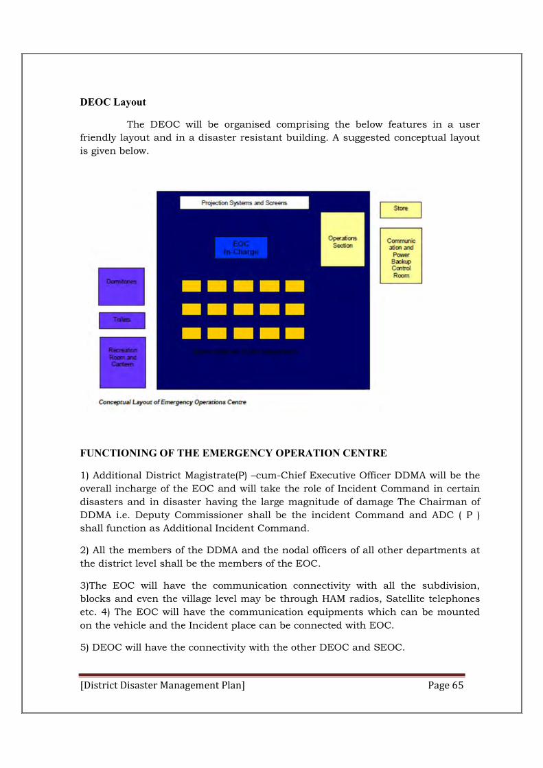
[District Disaster Management Plan] Page 65
DEOC Layout
The DEOC will be organised comprising the below features in a user
friendly layout and in a disaster resistant building. A suggested conceptual layout
is given below.
FUNCTIONING OF THE EMERGENCY OPERATION CENTRE
1) Additional District Magistrate(P) –cum-Chief Executive Officer DDMA will be the
overall incharge of the EOC and will take the role of Incident Command in certain
disasters and in disaster having the large magnitude of damage The Chairman of
DDMA i.e. Deputy Commissioner shall be the incident Command and ADC ( P )
shall function as Additional Incident Command.
2) All the members of the DDMA and the nodal officers of all other departments at
the district level shall be the members of the EOC.
3)The EOC will have the communication connectivity with all the subdivision,
blocks and even the village level may be through HAM radios, Satellite telephones
etc. 4) The EOC will have the communication equipments which can be mounted
on the vehicle and the Incident place can be connected with EOC.
5) DEOC will have the connectivity with the other DEOC and SEOC.
[District Disaster Management Plan] Page 66
6) DEOC will have the Disaster management plan of the different departments of
the district and other agencies operating in the district along with the Subdivision
and block level DM plans.
7) Resource inventories of all the departments at the district level along with their
locations.
8) Demographic. Socioeconomic data of the district village wise.
4.4 TRIGGER MECHANISM & INCIDENT RESPONSE SYSTEM (IRS)
This Trigger Mechanism prescribes the manner in which the disaster response
system shall be automatically activated after receiving early warning signals of a
disaster happening or likely to happen or on receipt of information of an
incident. Activities envisaged in this SOP under the response Phase shall be
initiated simultaneously without loss of time to minimize the loss and damage
and mitigate the impact of disaster.
The objective of having a trigger mechanism for natural disasters is to have a
suo- motto activation mechanism for spontaneous response to set in motion
command, control and management of the situation. There shall be two types of
situation with different trigger mechanisms for natural disasters:
(i) Situation I – Where Early Warning signals are available
(ii) Situation II- Where Disaster occurs without early warning
In addition to the District Incident Command Team (DICT), there will be four
Subdivisional level Incident Command Teams (SICTs) which can be deployed at
thesite of a complex emergency/disaster. Asand when required, these SICTs will be
deployed at the site of an emergency/disaster for on-scenemanagement. The
teams will focus on the operational aspects of response management,
dulysupported by other functions in ICS, e.g. Planning, Logistics, Finance / ADCn,
etc. The District-level Incident Command Team core management structure Shown
inFigure
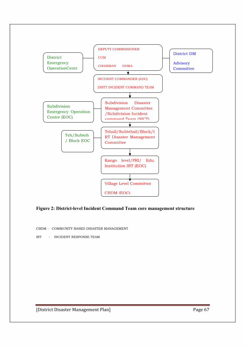
[District Disaster Management Plan] Page 67
Figure 2: District-level Incident Command Team core management structure
CBDM - COMMUNITY BASED DISASTER MANAGEMENT
IRT - INCIDENT RESPONSE TEAM
Tehsil/Subtehsil/Block/I
RT Disaster Management
Committee
Kango level/PRI/ Edu.
Institution IRT (EOC)
Village Level Committee
CBDM (EOC)
Subdivision Disaster
Management Committee
/Subdivision Incident
command Team (SICT)
Subdivision
Emergency Operation
Centre (EOC)
Teh/Subteh
/ Block EOC
INCIDENT COMMANDER (ADC)
DISTT INCIDENT COMMAND TEAM
District DM
Advisory
Committee
DEPUTY COMMISSIONER
CUM
CHAIRMAN DDMA
District
Emergency
OperationCentr
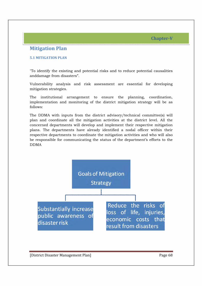
[District Disaster Management Plan] Page 68
Chapter-V
Mitigation Plan
5.1 MITIGATION PLAN
"To identify the existing and potential risks and to reduce potential causalities
anddamage from disasters”.
Vulnerability analysis and risk assessment are essential for developing
mitigation strategies.
The institutional arrangement to ensure the planning, coordination,
implementation and monitoring of the district mitigation strategy will be as
follows:
The DDMA with inputs from the district advisory/technical committee(s) will
plan and coordinate all the mitigation activities at the district level. All the
concerned departments will develop and implement their respective mitigation
plans. The departments have already identified a nodal officer within their
respective departments to coordinate the mitigation activities and who will also
be responsible for communicating the status of the department’s efforts to the
DDMA
[District Disaster Management Plan] Page 69
Hamirpur district is prone to 24 types of hazards out of the 25 types of hazards to
which Himachal Pradesh as a whole is vulnerable to as identified by the High
Power Committee Government of India. Mitigation plans will be developed and
adapted locally. Mitigation strategies need to ensure the higher level of community
involvement and participation. In rural areas, characterized by inadequate
infrastructure and poverty groups, all mitigation efforts will have to be backed up
by a strong and committed programme of social development for the communities.
Constant re-examination, therefore, of development Policies and programmes,
leading to equity and social justice, will be pre-requisite to ensure the success of
mitigation efforts that are being proposed.
Keeping in view the hazard and vulnerability profile of the district the following
mitigation actions would be taken to mitigate the impacts of various hazards.
The main elements of mitigation strategy are:
1) Risk Assessment and Vulnerability Analysis
Every department at district level will analyze the specific risks faced by the
department in that area or subject on which the department has the
jurisdiction. The concerned department will do a risk and vulnerability analysis
and prepare a report and present it to DDMA. The NODAL OFFICER of
concerned department will be responsible for the said assignment. DDMA will
take cognizance of the report and action will be taken accordingly.
2) Construction work
As and when the earthquake resistant features will be incorporated in the
building by-laws of the State and adequate zoning laws will be put in place to
regulate development away from unsafe locations, the concerned department
will be responsible for implementation and raising public awareness about
these laws.
3) Infrastructure and Housing Repair and Maintenance
Housing and Roads and Bridges are the two issues which are important in view
of disaster.For mitigation of earthquake retrofitting and renovation of lifeline
buildings has paramount importance. Lifeline buildings represent critical
infrastructure for the state, such as schools andhospitals. The Public works
department will be the primary agency responsible of conducting structural
assessment, retrofitting and renovation of lifeline buildings. Existing
development programmes may be examined to incorporate disaster resistant
technologies in all existing and new public buildings. PWD will be responsible
for preparing a risk and vulnerability analysis report and present it to DDMA.
The NODAL OFFICER of PWD department will be responsible for the said
assignment. DDMA will take cognizance of the report and action will be taken
[District Disaster Management Plan] Page 70
accordingly. Embankments/Banks/Dams and water resources, construction,
strengthening of micro level protection features need to be identified andtaken
on priority in areas with recurrent threat of floods, and other water related
disasters. IPH will be responsible for preparing a risk and vulnerability analysis
report and present it to DDMA. The NODAL OFFICER of IPH department will be
responsible for the said assignment. DDMA will take cognizance of the report
and action will be taken accordingly.
All the departments will have to ensure that mitigation measures are
incorporated into repairs, major alterations, new development, and
redevelopment practices, especially in areas subject to substantial risk from
hazards.
For the rural areas, the Rural development department will coordinate with the
district and authority to ensure that mitigation measures all been implemented.
Under the National Rural Employment Guarantee Act, provide for strengthening
and maintenance of such physical features that may vitally protect/help in rescue
of communities during disaster situations.
For the urban areas, the Urban Development department will coordinate with the
district authorities to ensure that mitigation measures are included.
4) Research and Technology Transfer
Under the guidance of Science and Environment department, PWD will
establish and maintain partnerships between all levels of government, the
private sector, community groups, and institutions of higher learning that
improve and implement methods to protect life and property.
DDMA has identified research institution NIT Hamirpur to evolve mitigation
strategies.
5) Training and Capacity Building
Training and Capacity Building of Government Officials:
At the district level, training programmes had been conducted in coordination
with NGOs, NIT Hamirpur and government training/research institutions.
6) Climate Change adaptation
There are evidences to indicate that Himalayas are warming at a higher rate than
the global average rate. Himalayas are the maker of climate of much of the South
Asia, and the Himalayas glaciers are receding faster than glaciers of the other parts
of world. Alpine ecosystems are particularly vulnerable to warming. Many
important forest species are likely to fail to regenerate if the synchrony between
[District Disaster Management Plan] Page 71
their seed ripening and commencement of monsoon rains is broken due to the
climate change. Therefore, climate change is likely to impact our glacial reserves,
water balance, agriculture, forestry, bio-diversity and human and animal health.
There are definite indications that climate change would increase the frequency
and intensity of natural disasters like cyclones, floods, cloudbursts, flash floods
and droughts in the coming years. In order to meet these challenges in a sustained
and effective manner, synergies in our approach and strategies for climate change
adaptation and disaster risk reductions hall be encouraged and promoted.
7) Structural & Non structural Measures
1) Structural Measures
2) Non Structural measures
3) Disaster Mitigation Projects
These measures should be taken by all the departments while preparing and
execution of the plans.
5.2 Community Level Training and Public Awareness Activities:
HIPA has already organized a workshop on community based disaster
management (CBDM) in July, 2014.The community awareness and training
activities has been basically carried out in the form of training programmes
through NGOs, Private Sector, and Government Training Institutions. Apart
from spreading awareness of disasters, the focus will essentially be on
community capacity building.
Special focus will be given to local contractors and masons, who are the prime
responsible for construction work. Training programmes will target the informal
construction sector by building their capacities on safe construction practices
and retrofitting of existing structures. An institutional arrangement is required
to ensure that in the long term, contractors and mason ensure safe
construction practices.
5.3 Local Level Preparedness:
The Government realizes the fact the first responder at the time of any disaster is
the local level community and hence there is no alternate other than to train them
in a way so that they are competent to respond to any incident in an effective way.
The areas which are required to be specifically addressed during these trainings
are :-
1) Search and rescue methods and procedures so as to minimize the loss of life
2) Medical First Aid required to be given on the spot.
[District Disaster Management Plan] Page 72
3) Fire Fighting techniques
4) Dos and dont’s during such disaster
5) How to use communication systems like ham radios, satellite stations etc.
5.4 Primary agencies for community level training and public awareness are:
Environment, scientific and technology department, Technical Education
Department, NGO, Private sectors, The NGOs, private sector organizations and
other government training institutions will, in turn, organize training and
simulation exercises at the district and community level, in order to ensure
preparedness from the grass-roots.
5.5 Mobilizing Community Efforts for Mitigation Measures:
The community will be encouraged to reduce the impact of the next disaster.
Demonstration housing units indicating the various technology features and
options will be built by the Government/NGOs/Community. This should
prioritize buildings like village offices, primary health centers, community
centre, schools etc. The objective of such activity will be to encourage local
communities to undertake either at individual, household or community level to
avoid loss of life, damage to property and crop.
Land Use Planning and Regulations
The office of department of Town and Country planning will be primary agency
to encourage new development to occur in locations avoiding or minimizing
exposure to hazards or enhance design requirements to improve resiliency in
future disasters. This office should also ensure proper enforcement of existing
regulations and acts.
Incentives and Resources for Mitigation
The main source for funding will be State Disaster Mitigation Fund to
implement the above stated mitigation strategy. The fund will be used to
provide incentives to developmental projects where mitigation measures have
been adopted. Leveraging of funds from other developmental schemes also
needs to be taken into account.
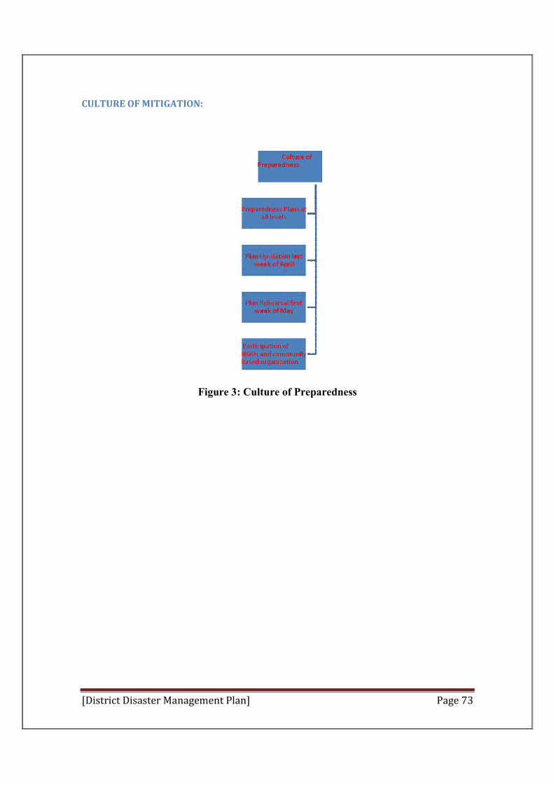
[District Disaster Management Plan] Page 73
CULTURE OF MITIGATION:
Figure 3: Culture of Preparedness
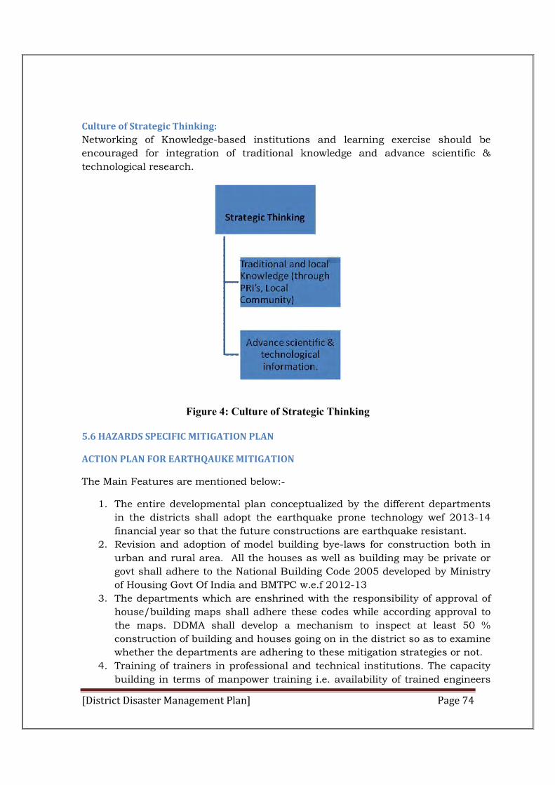
[District Disaster Management Plan] Page 74
Culture of Strategic Thinking:
Networking of Knowledge-based institutions and learning exercise should be
encouraged for integration of traditional knowledge and advance scientific &
technological research.
Figure 4: Culture of Strategic Thinking
5.6 HAZARDS SPECIFIC MITIGATION PLAN
ACTION PLAN FOR EARTHQAUKE MITIGATION
The Main Features are mentioned below:-
1. The entire developmental plan conceptualized by the different departments
in the districts shall adopt the earthquake prone technology wef 2013-14
financial year so that the future constructions are earthquake resistant.
2. Revision and adoption of model building bye-laws for construction both in
urban and rural area. All the houses as well as building may be private or
govt shall adhere to the National Building Code 2005 developed by Ministry
of Housing Govt Of India and BMTPC w.e.f 2012-13
3. The departments which are enshrined with the responsibility of approval of
house/building maps shall adhere these codes while according approval to
the maps. DDMA shall develop a mechanism to inspect at least 50 %
construction of building and houses going on in the district so as to examine
whether the departments are adhering to these mitigation strategies or not.
4. Training of trainers in professional and technical institutions. The capacity
building in terms of manpower training i.e. availability of trained engineers
[District Disaster Management Plan] Page 75
in public as well as in private sector shall be enhanced by the DDMA by way
of imparting training and certifying.
5. Launching public awareness campaigns on seismic safety and risk reduction
and sensitising all stakeholders to earthquake mitigation.
6. Assessing the seismic risk and vulnerability of the existing built
environment by carrying out structural safety audits of all critical lifeline
structures.
7. Training and capacity building of the informal masons who are deployed by
the general public for construction of houses in the rural areas. DDMA shall
maintain a directory of such masons so trained through the BDOS.
8. Introducing earthquake safety education and preparation of DM plans by
schools, colleges, universities and and conducting mock drills in these
institutions.
9. Introducing earthquake safety education in hospitals, main buildings visited
by large number of public etc. Conducting of mock drills so that they should
have a safe plan in case of such disaster.
10. Preparing community and village level DM plans, with specific reference to
management of earthquakes and carrying out mock drills up to the block
level /village level for enhancing preparedness.
11. Strengthening the medical preparedness for effective earthquake response.
ACTION PLAN FOR LANDSLIDE MITIGATION The Main Features to be incorporated is mentioned below:‐
1. The Town planning department at the district level in urban areas shall
resurvey the areas and make land use plan town wise so that the areas
which are vulnerable to land slide could not be used for construction of
buildings for residential as well as commercial purpose.
2. Revision of town planning bye-laws and adoption of model land use bye-
laws in hilly areas.
3. The local bodies which are ADCinistering the approval of map shall
ensure while according approval that no such approval be given in the land
slide zone areas.
4. Drawing up a stategy and plan of action for mitigating the impacts of
landslides, provide advice and guidance on various aspects of landslide
mitigation, monitor the activities relating to landslide mitigation includind
landslide zonation and to evolve early warning system and protocol for
landslide reduction.
5. Training of trainers in professional and technical institutions.
6. Training of professionals like engineers and geologists for landslide
mapping, investigation techniques, analysis, and observational practices.
[District Disaster Management Plan] Page 76
7. Launching public awareness campaigns on land slide hazard and risk
reduction, and sensitising all stakeholders on landslide hazard mitigation.
8. Assessing the status of risk and vulnerability of the existing built
environment.
9. Preparing an inventory of existing landslides, active or inactive, in the
area.
10. Developing an inventory of the existing built environment in areas
around existing landslides and in high hazard zones as per the LHZ maps.
11. Preparation of DM plans by educational and health
institutes/organisations, government offices, etc., and carrying out mock
drills for enhancing preparedness in vulnerable areas. 12. Strengthening the
DEOC and communication network.
13. Streamlining the mobilisation of communities, government agencies, the
corporate sector, and other stakeholders.
14. Preparing community and village level DM plans, with specific reference
to the management of landslides.
ACTION PLAN FOR DROUGHT MITIGATION
Main features of mitigation plan includes:‐
1. Drought management plans for the entire season will be prepared by
the Agriculture Department in advance in the month of May, based
on the long season forecast issued by IMD in April and also the
previous season’s rainfall.
2. The agriculture department at the district level shall prepare the
mitigation plan for such occurrence block wise.
3. As the season progresses from June onwards, the DDMA will review
the plans prepared earlier at the onset of the monsoon and revise the
strategy if required.
4. Weekly monitoring of these as on and crop condition from June
onwards till the DDMP end of the season and make necessary mid-
season corrections as and when required.
5. Agriculture department shall use the remote sensing and GIS
technology while providing inputs to the DDMA.
6. A sound data base shall be prepared by the agriculture department
on weather, crop conditions, and input supply to assist the DDMA.
7. The techniques of rain water harvesting technology will be
disseminated among the farmers in the rural areas.
8. The DDMA will make use of the frontier techniques like remote
sensing and GIS.
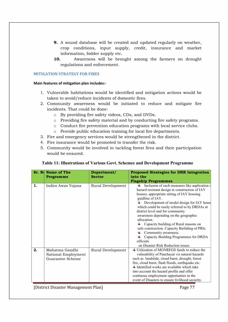
[District Disaster Management Plan] Page 77
9. A sound database will be created and updated regularly on weather,
crop conditions, input supply, credit, insurance and market
information, fodder supply etc.
10. Awareness will be brought among the farmers on drought
regulations and enforcement.
MITIGATION STRATEGY FOR FIRES
Main features of mitigation plan includes:‐
1. Vulnerable habitations would be identified and mitigation actions would be
taken to avoid/reduce incidents of domestic fires.
2. Community awareness would be initiated to reduce and mitigate fire
incidents. That could be done:
o By providing fire safety videos, CDs, and DVDs.
o Providing fire safety material and by conducting fire safety programs.
o Conduct fire prevention education programs with local service clubs.
o Provide public education training for local fire departments.
3. Fire and emergency services would be strengthened in the district.
4. Fire insurance would be promoted to transfer the risk.
5. Community would be involved in tackling forest fires and their participation
would be ensured.
Table 11: Illustrations of Various Govt. Schemes and Development Programme
Sr. No.Name of The Programme
Department/ Sector
Proposed Strategies for DRR Integration into the Flagship Programmes
1. Indira Awas Yojana Rural Development Inclusion of such measures like aaplication of hazard resistant design in construction of IAY houses, appropriate sitting of IAY housing guidline of IAY.
Development of model design for IAY houses which could be easily referred to by DRDAs at district level and for community awareness depending on the geographic allocation.
Capacity building of Rural masons on safe construction. Capacity Builiding of PRIs.
Community awareness. Capacity Building Programmes for DRDA
officials on Disaster Risk Reduction issues.
2. Mahatma Gandhi National Employment Guarantee Scheme
Rural Development Utilization of MGNREGS funds to reduce the vulneability of Panchayat vis natural hazards
such as landslide, cloud burst, drought, forest fire, cloud burst, flash floods, earthquake etc.
Identified works are available which take into account the hazard profile and offer continous employment oppertunties in the event of Disasters to ensure livlihood security.
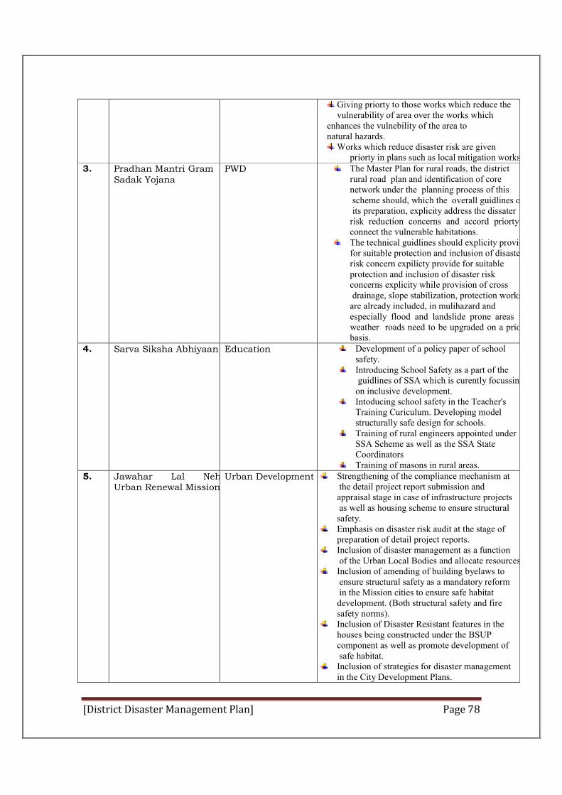
[District Disaster Management Plan] Page 78
Giving priorty to those works which reduce the vulnerability of area over the works which
enhances the vulnebility of the area to natural hazards.
Works which reduce disaster risk are given priorty in plans such as local mitigation works.
3. Pradhan Mantri Gram Sadak Yojana
PWD The Master Plan for rural roads, the district rural road plan and identification of core network under the planning process of this scheme should, which the overall guidlines of its preparation, explicity address the dissater risk reduction concerns and accord priorty to connect the vulnerable habitations.
The technical guidlines should explicity provide for suitable protection and inclusion of disasterrisk concern expilicty provide for suitable protection and inclusion of disaster risk concerns explicity while provision of cross drainage, slope stabilization, protection works are already included, in mulihazard and especially flood and landslide prone areas fair weather roads need to be upgraded on a priorty basis.
4. Sarva Siksha Abhiyaan Education Development of a policy paper of school safety.
Introducing School Safety as a part of the guidlines of SSA which is curently focussing on inclusive development.
Intoducing school safety in the Teacher's Training Curiculum. Developing model structurally safe design for schools.
Training of rural engineers appointed under SSA Scheme as well as the SSA State Coordinators
Training of masons in rural areas. 5. Jawahar Lal Nehru
Urban Renewal MissionUrban Development Strengthening of the compliance mechanism at
the detail project report submission and appraisal stage in case of infrastructure projects as well as housing scheme to ensure structural safety.
Emphasis on disaster risk audit at the stage of preparation of detail project reports.
Inclusion of disaster management as a function of the Urban Local Bodies and allocate resources.
Inclusion of amending of building byelaws to ensure structural safety as a mandatory reform in the Mission cities to ensure safe habitat development. (Both structural safety and fire safety norms).
Inclusion of Disaster Resistant features in the houses being constructed under the BSUP component as well as promote development of safe habitat.
Inclusion of strategies for disaster management in the City Development Plans.
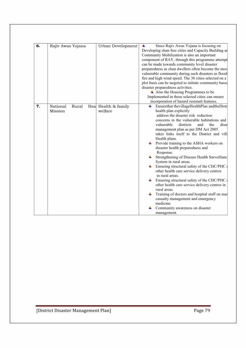
[District Disaster Management Plan] Page 79
6. Rajiv Awas Yojana Urban Development Since Rajiv Awas Yojana is focusing on Developing slum free cities and Capacity Building and Community Mobilization is also an important component of RAY, through this programme attempts can be made towards community level disaster preparedness as slum dwellers often become the most vulnerable community during such disasters as floods, fire and high wind speed. The 30 cities selected on a plot basis can be targeted to initiate community based disaster preparedness activities.
Also the Housing Programmes to be Implemented in these selected cities can ensure
incorporation of hazard resistant features. 7. National Rural Health
Mission Health & family welfare
Ensurethat thevillageHealthPlan andtheDistrict health plan explicitly address the disaster risk reduction concerns in the vulnerable habitations and the vulnerable districts and the disaster management plan as per DM Act 2005 takes links itself to the District and village Health plans.
Provide training to the ASHA workers on disaster health preparedness and Response.
Strengthening of Disease Health Surveillance System in rural areas.
Ensuring structural safety of the CHC/PHC and other health care service delivery centres in rural areas.
Ensuring structural safety of the CHC/PHC and other health care service delivery centres in rural areas.
Training of doctors and hospital staff on mass casualty management and emergency medicine.
Community awareness on disaster management.
[District Disaster Management Plan] Page 80
Chapter-VI
6.1 Response Plan In view of the provisions of the DM Act 2005 and the ADCinistrative structure
existing in the country at the District and State levels, the roles of the Chief
Secretary (CS) and theDistrict Magistrates / DC are all encompassing as
regards response. In the IRS, a need was felt to clearly identify a designated
authority responsible and accountable by law to respond to disasters and
therefore a position of Responsible Officer (RO) has been introduced. Incident
response management may however not always require the direct intervention
of the RO. On the ground, the management will be done by the IC to whom
powers will have to be delegated by the RO. District Magistrates/DCs will
perform the role of ROs in their respective ADCinistrative jurisdictions and will
be overall responsible for all response activities during any incident or crisis.
As per the DM Act, the District Magistrate / DC is the Chairperson of the
DDMA and has been assigned all encompassing role of planning, coordination
and execution of DM in his jurisdiction assisted by all line departments and
local bodies. The responsibility for disaster response clearly lies with the
District Magistrate/DC being the head of the District ADCinistration. It will only
be the ADCinistrative machinery – District Magistrate / DC and their team of
officers who will be responsible and accountable for effective response in their
jurisdictions.
Roles and Responsibilities of District Magistrate as RO
Ensure that IRTs are formed at District, Sub-Division, Tehsil/Block levels and IRS is integrated in the District DM Plan as per Section 31 of the DM Act, 2005. This may be achieved by issuing a Standing Order by the RO to all SDOs, SDMs and Tehsildars/ BDOs;
Ensure web based / on line Decision Support System (DSS) is in place in EOC and connected with Sub-Division and Tehsil / Block level IRTs for support;
Ensure that toll free emergency numbers existing for Police, Fire and Medical support etc. are linked to the EOC for response, command and control. For e.g., if there is any fire incident, the information should not only reach the fire station but also the EOC and the nearest hospital to gear up the emergency medical service;
Obtain funds from State Government as recommended by the 13th Finance Commission and ensure that a training calendar for IRTs of District is prepared and members of IRTs are trained through training institutions of the District;
Delegate authorities to the IC;
[District Disaster Management Plan] Page 81
Activate IRTs at District headquarter, Sub-Division, Tehsil / Block levels, as and when required;
Appoint / deploy, terminate and demobilize IC and IRT(s) as and when required;
Decide overall incident objectives, priorities and ensure that various objectives do not conflict with each other;
Ensure that IAP is prepared by the IC and implemented; Remains fully briefed on the IAP and its implementation; Coordinates all response activities;
Give directions for the release and use of resources available with any department of the Government, Local Authority, private sector etc. in the District;
Ensure that local Armed Forces Commanders are involved in the planning process and their resources are appropriately dovetailed, if required;
Appoint a NO at the District level to organize Air Operations in coordination with the
State and Central Government NO. Also ensure that all ICs of IRTs of the District are aware of it;
Ensure that the NGOs carry out their activities in an equitable and non- discriminatory manner;
Deploy the District Headquarter IRTs at the incident site, in case of need; Ensure that effective communications are in place; Ensure that telephone directory of all ESF is prepared and available with
EOC and members of IRTs; Ensure provision for accountability of personnel and a safe operating
environment; In case the situation deteriorates; the RO may assume the role of the IC
and may seek support from the State level RO; Mobilize experts and consultants in the relevant fields to advise and
assist as he may deem necessary; Procure exclusive or preferential use of amenities from any authority or
person; Conduct post response review on performance of IRTs and take
appropriate steps to improve performance; and Take other necessary action as the situation demands.
Roles of Local Authorities PRIs and ULBs
The DM Act, 2005 has defined the roles of NACs, Municipalities, Municipal
Corporations, Municipal Councils and PRIs under section 41 (1) (2). These
bodies will ensure that their officials and employees are trained in DM and
resources relating to DM are also maintained in order to be readily available for
use in any threatening disaster situation or disaster. These bodies are also
required to carry out relief activities in the affected areas in accordance with
District DM Plans. The DDMAs will lay down the specific roles and
responsibilities of these local bodies in the DM Plan and suitably integrate them
with relevant IRTs.
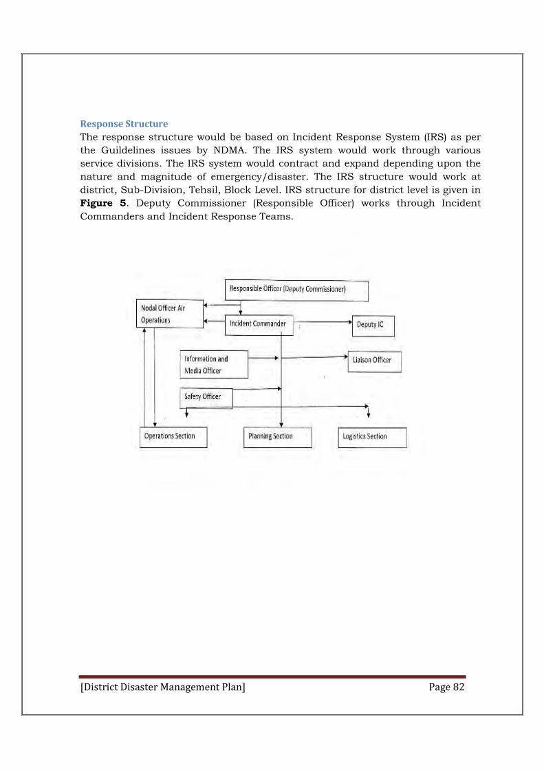
[District Disaster Management Plan] Page 82
Response Structure
The response structure would be based on Incident Response System (IRS) as per
the Guildelines issues by NDMA. The IRS system would work through various
service divisions. The IRS system would contract and expand depending upon the
nature and magnitude of emergency/disaster. The IRS structure would work at
district, Sub-Division, Tehsil, Block Level. IRS structure for district level is given in
Figure 5. Deputy Commissioner (Responsible Officer) works through Incident
Commanders and Incident Response Teams.

[District Disaster Management Plan] Page 83
Figure 6: IRT Framework
Incident Response Team (IRT)
The RO of the District will constitute IRTs from among officers at District level. The
members of IRTs will be properly trained and sensitized regarding their roles
during the pre-disaster phase itself. Selection of different section chiefs will be
guided by the nature and type of disaster. The headquarters IRT will provide
continuous support to the on-scene IRT(s) and if required join them or take over
response on the directions of the RO.
Incident Response System (IRS) - Facilities
For effective response the following facilities may be required to be established
depending on the needs of the incidents, the length and time the facilities are
needed to be used, the cost to establish it and prevailing weather conditions etc.
Incident Command Post (ICP)
The ICP is the location at which the primary command functions are performed.
The IC will be located at the ICP. There will only be one ICP for each incident.
This also applies to situations with multi-agencies or multi jurisdictional
incidents operating under a single or Unified command. The ICP can be located
with other incident facilities like Incident Base.
[District Disaster Management Plan] Page 84
The ICP may be located at Headquarters of various levels of ADCinistration
(State, District, Sub-Division, Tehsil / Block). In case of total destruction or
reasons of non availability of any other space, the ICP may be located in a
vehicle, trailer or tent. It should however have adequate lighting, effective
communication system and other such facilities so that one can function
effectively.
Deployment of IRT
Some of the natural hazards have a well established early warning system.
States andDistricts also have a functional 24 x 7 EOC / Control Room. On
receipt of information regarding the impending disaster, the EOC will inform the
RO, who in turn will activate the required IRT and mobilize resources. The scale
of their deployment will depend on the magnitude of the incident. At times the
information about an incident may be received only on its occurrence without
any warning. In such cases the local IRT (District, Sub-Division, Tehsil / Block)
as the case may be, will respond and inform the higher authority and if
required seek reinforcement and guidance.
Objectives of the Emergency Operations Centre
The EOCs/Control Rooms at District, Subdivision, Tehsil, Block levels will be the nerve centre for coordination and management of disasters. The objectives of the EOCs shall be to provide centralized direction and control of any or all of the following functions:
Receive and process disaster alerts and warnings from nodal agencies and other sources and communicate the same to all designated authorities.
Monitor emergency operations Facilitate Coordination among primary and secondary ESF
Departments/Agencies. Requisitioning additional resources during the disaster phase Issuing
disaster/incident specific information and instructions specific to all concerned;
Consolidation, analysis, and dissemination of damage, loss and needs assessment data;
Forwarding of consolidated reports to all designated authorities.
Location of EOC
The EOC will be set up at a suitable location and the building should be
disaster proof so as to withstand the impact of disasters and remain functional
during the emergency phase. In district Hamirpur, DEOC is established in
Room no. 308, Office of the Deputy Commissioner, Hamirpur.
Communication Network of EOCs
Under the National Communication Plan being implemented by the Government
of India, the EOCs at all the three levels shall have a fail proof communication
network with triple redundancy of NICNET of NIC, POLNET of Police and
[District Disaster Management Plan] Page 85
SPACENET of ISRO in addition to the terrestrial and satellite based
communication to ensure voice, data and video transfer.
Under the network, the EOCs/Control Rooms of all the States will be directly
connected with the NEOC/ Control Room of MHA at the National level. The
district EOCs/ Control
Rooms will be connected with the respective State EOCs/Control Room. All
these control rooms will function on 24x7 basis and will be functional round
the year. Suitable personnel will be selected and imparted training in the
operation of Control Rooms will be posted to man these EOCs/Control Rooms.
In EOC, Hamirpur, 4 TSPN Lines (1077) toll free no. is available.
DEOC
District Administration shall set up District Emergency OperationCentre and
provide adequate manpower for manning them on 24x7 basis round the year
and arrange training for the EOC Staff on EOC operations. District
Administration shall develop SOP/ Protocol for activation of DEOCs during
emergency/disasters. During moonsoon season, District Administration dipute
2 persons in DEOC for proper communication at the time of disaster.
DEOC Layout
The DEOC will be organised comprising the below features in a user friendly layout
and in a disaster resistant building. A suggested conceptual layout is given below.
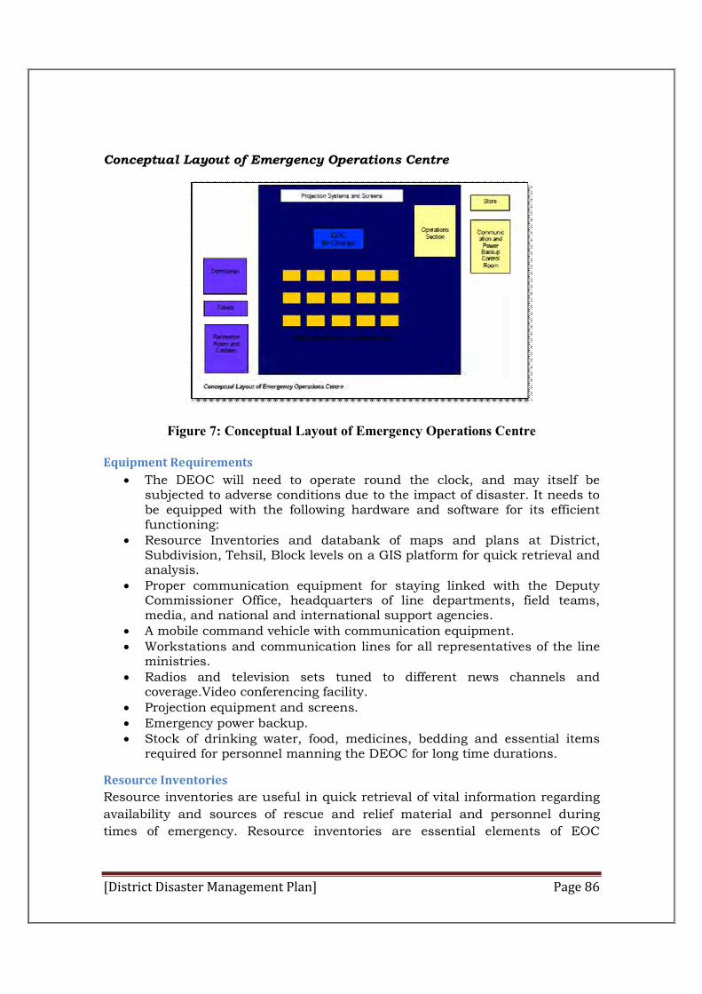
[District Disaster Management Plan] Page 86
Conceptual Layout of Emergency Operations Centre
Figure 7: Conceptual Layout of Emergency Operations Centre
Equipment Requirements
The DEOC will need to operate round the clock, and may itself be subjected to adverse conditions due to the impact of disaster. It needs to be equipped with the following hardware and software for its efficient functioning:
Resource Inventories and databank of maps and plans at District, Subdivision, Tehsil, Block levels on a GIS platform for quick retrieval and analysis.
Proper communication equipment for staying linked with the Deputy Commissioner Office, headquarters of line departments, field teams, media, and national and international support agencies.
A mobile command vehicle with communication equipment. Workstations and communication lines for all representatives of the line
ministries. Radios and television sets tuned to different news channels and
coverage.Video conferencing facility. Projection equipment and screens. Emergency power backup. Stock of drinking water, food, medicines, bedding and essential items
required for personnel manning the DEOC for long time durations.
Resource Inventories
Resource inventories are useful in quick retrieval of vital information regarding
availability and sources of rescue and relief material and personnel during
times of emergency. Resource inventories are essential elements of EOC
[District Disaster Management Plan] Page 87
operations. Such inventories has been prepared and maintained through
regular updating at the District level.
Inventories include the following basic elements, and other locally relevant
information:
Contact details of all personnel and organizations concerned with emergency management
List, with specifications and availability procedures, of all equipment that may be useful for responding to an emergency. This will include communication equipment, transport vehicles, earth moving equipment, cranes, and tools etc. that are available with agencies within the jurisdiction.
List, with specifications and rate schedules, of relief material that can be sourced from local aid agencies and markets. This will include dry rations, tents and bedding, clothing, utensils, first-aid items and other basic necessity items
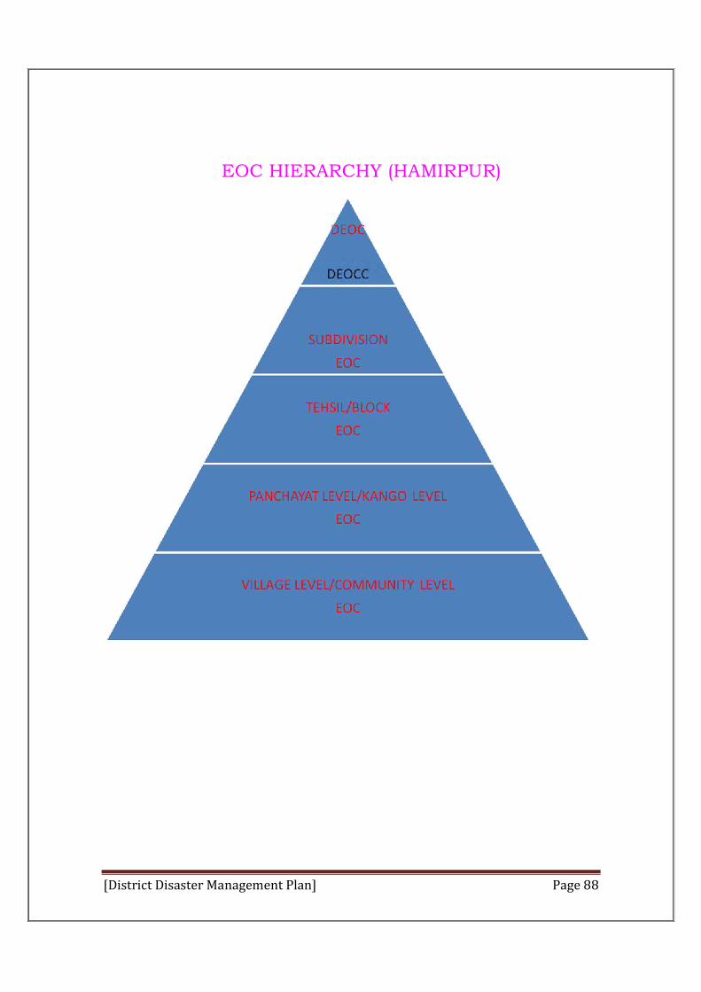
[District Disaster Management Plan] Page 88
EOC HIERARCHY (HAMIRPUR)
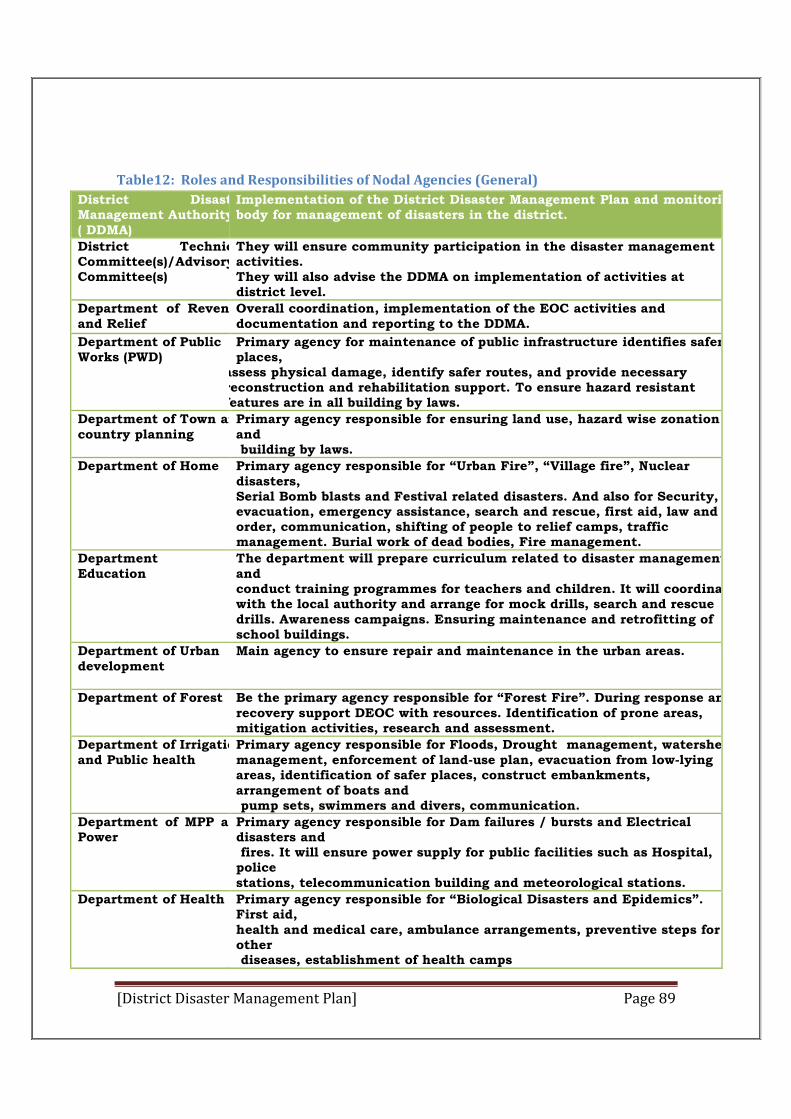
[District Disaster Management Plan] Page 89
Table12: Roles and Responsibilities of Nodal Agencies (General)
District Disaster Management Authority( DDMA)
Implementation of the District Disaster Management Plan and monitoring body for management of disasters in the district.
District Technical Committee(s)/Advisory Committee(s)
They will ensure community participation in the disaster management activities. They will also advise the DDMA on implementation of activities at district level.
Department of Revenue and Relief
Overall coordination, implementation of the EOC activities and documentation and reporting to the DDMA.
Department of Public Works (PWD)
Primary agency for maintenance of public infrastructure identifies safer places,
assess physical damage, identify safer routes, and provide necessary reconstruction and rehabilitation support. To ensure hazard resistant features are in all building by laws.
Department of Town andcountry planning
Primary agency responsible for ensuring land use, hazard wise zonation and building by laws.
Department of Home Primary agency responsible for “Urban Fire”, “Village fire”, Nuclear disasters, Serial Bomb blasts and Festival related disasters. And also for Security, evacuation, emergency assistance, search and rescue, first aid, law and order, communication, shifting of people to relief camps, traffic management. Burial work of dead bodies, Fire management.
Department of Education
The department will prepare curriculum related to disaster management and conduct training programmes for teachers and children. It will coordinate with the local authority and arrange for mock drills, search and rescue drills. Awareness campaigns. Ensuring maintenance and retrofitting of school buildings.
Department of Urban development
Main agency to ensure repair and maintenance in the urban areas.
Department of Forest
Be the primary agency responsible for “Forest Fire”. During response and recovery support DEOC with resources. Identification of prone areas, mitigation activities, research and assessment.
Department of Irrigationand Public health
Primary agency responsible for Floods, Drought management, watershed management, enforcement of land-use plan, evacuation from low-lying areas, identification of safer places, construct embankments, arrangement of boats and pump sets, swimmers and divers, communication.
Department of MPP and Power
Primary agency responsible for Dam failures / bursts and Electrical disasters and fires. It will ensure power supply for public facilities such as Hospital, police stations, telecommunication building and meteorological stations.
Department of Health
Primary agency responsible for “Biological Disasters and Epidemics”. First aid, health and medical care, ambulance arrangements, preventive steps for other diseases, establishment of health camps
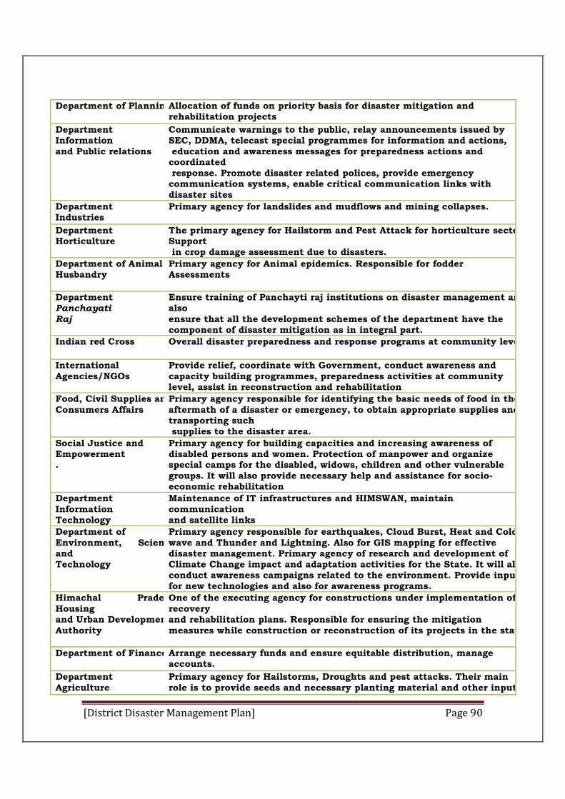
[District Disaster Management Plan] Page 90
Department of Planning
Allocation of funds on priority basis for disaster mitigation and rehabilitation projects
Department of Information and Public relations
Communicate warnings to the public, relay announcements issued by SEC, DDMA, telecast special programmes for information and actions, education and awareness messages for preparedness actions and coordinated response. Promote disaster related polices, provide emergency communication systems, enable critical communication links with disaster sites
Department of Industries
Primary agency for landslides and mudflows and mining collapses.
Department of Horticulture
The primary agency for Hailstorm and Pest Attack for horticulture sector. Support in crop damage assessment due to disasters.
Department of Animal Husbandry
Primary agency for Animal epidemics. Responsible for fodder Assessments
Department of Panchayati Raj
Ensure training of Panchayti raj institutions on disaster management and also ensure that all the development schemes of the department have the component of disaster mitigation as in integral part.
Indian red Cross Overall disaster preparedness and response programs at community level
International Agencies/NGOs
Provide relief, coordinate with Government, conduct awareness and capacity building programmes, preparedness activities at community level, assist in reconstruction and rehabilitation
Food, Civil Supplies andConsumers Affairs
Primary agency responsible for identifying the basic needs of food in the aftermath of a disaster or emergency, to obtain appropriate supplies and transporting such supplies to the disaster area.
Social Justice and Empowerment .
Primary agency for building capacities and increasing awareness of disabled persons and women. Protection of manpower and organize special camps for the disabled, widows, children and other vulnerable groups. It will also provide necessary help and assistance for socio-economic rehabilitation
Department Information Technology
Maintenance of IT infrastructures and HIMSWAN, maintain communication and satellite links
Department of Environment, Science and Technology
Primary agency responsible for earthquakes, Cloud Burst, Heat and Cold wave and Thunder and Lightning. Also for GIS mapping for effective disaster management. Primary agency of research and development of Climate Change impact and adaptation activities for the State. It will also conduct awareness campaigns related to the environment. Provide inputs for new technologies and also for awareness programs.
Himachal Pradesh Housing and Urban DevelopmentAuthority
One of the executing agency for constructions under implementation of recovery and rehabilitation plans. Responsible for ensuring the mitigation measures while construction or reconstruction of its projects in the state.
Department of Finance
Arrange necessary funds and ensure equitable distribution, manage accounts.
Department of Agriculture
Primary agency for Hailstorms, Droughts and pest attacks. Their main role is to provide seeds and necessary planting material and other inputs
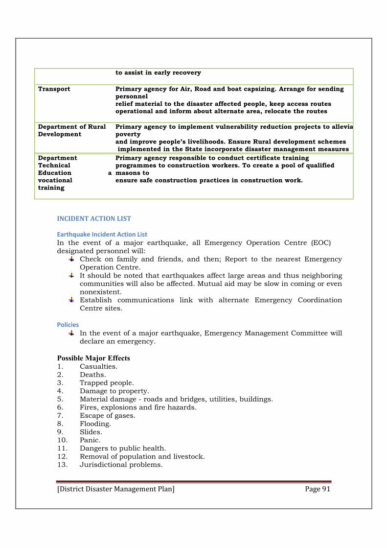
[District Disaster Management Plan] Page 91
to assist in early recovery
Transport
Primary agency for Air, Road and boat capsizing. Arrange for sending personnel relief material to the disaster affected people, keep access routes operational and inform about alternate area, relocate the routes
Department of Rural Development
Primary agency to implement vulnerability reduction projects to alleviate poverty and improve people’s livelihoods. Ensure Rural development schemes implemented in the State incorporate disaster management measures
Department of Technical Education and vocational training
Primary agency responsible to conduct certificate training programmes to construction workers. To create a pool of qualified masons to ensure safe construction practices in construction work.
INCIDENT ACTION LIST
Earthquake Incident Action List In the event of a major earthquake, all Emergency Operation Centre (EOC) designated personnel will:
Check on family and friends, and then; Report to the nearest Emergency Operation Centre.
It should be noted that earthquakes affect large areas and thus neighboring communities will also be affected. Mutual aid may be slow in coming or even nonexistent.
Establish communications link with alternate Emergency Coordination Centre sites.
Policies
In the event of a major earthquake, Emergency Management Committee will declare an emergency.
Possible Major Effects 1. Casualties. 2. Deaths. 3. Trapped people. 4. Damage to property. 5. Material damage - roads and bridges, utilities, buildings. 6. Fires, explosions and fire hazards. 7. Escape of gases. 8. Flooding. 9. Slides. 10. Panic. 11. Dangers to public health. 12. Removal of population and livestock. 13. Jurisdictional problems.
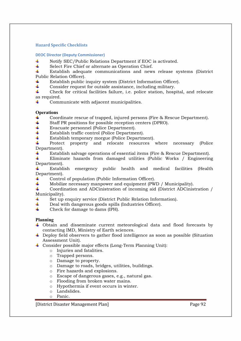
[District Disaster Management Plan] Page 92
Hazard Specific Checklists
DEOC Director (Deputy Commissioner)
Notify SEC/Public Relations Department if EOC is activated. Select Fire Chief or alternate as Operation Chief. Establish adequate communications and news release systems (District
Public Relation Officer). Establish public inquiry system (District Information Officer). Consider request for outside assistance, including military. Check for critical facilities failure, i.e. police station, hospital, and relocate
as required. Communicate with adjacent municipalities.
Operations
Coordinate rescue of trapped, injured persons (Fire & Rescue Department). Staff PR positions for possible reception centers (DPRO). Evacuate personnel (Police Department). Establish traffic control (Police Department). Establish temporary morgue (Police Department). Protect property and relocate resources where necessary (Police
Department). Establish salvage operations of essential items (Fire & Rescue Department). Eliminate hazards from damaged utilities (Public Works / Engineering
Department). Establish emergency public health and medical facilities (Health
Department). Control of population (Public Information Officer). Mobilize necessary manpower and equipment (PWD / Municipality). Coordination and ADCinistration of incoming aid (District ADCinistration /
Municipality). Set up enquiry service (District Public Relation Information). Deal with dangerous goods spills (Industries Officer). Check for damage to dams (IPH).
Planning
Obtain and disseminate current meteorological data and flood forecasts by contacting IMD, Ministry of Earth sciences.
Deploy field observers to gather flood intelligence as soon as possible (Situation Assessment Unit).
Consider possible major effects (Long-Term Planning Unit): o Injuries and fatalities. o Trapped persons. o Damage to property. o Damage to roads, bridges, utilities, buildings. o Fire hazards and explosions. o Escape of dangerous gases, e.g., natural gas. o Flooding from broken water mains. o Hypothermia if event occurs in winter. o Landslides. o Panic.
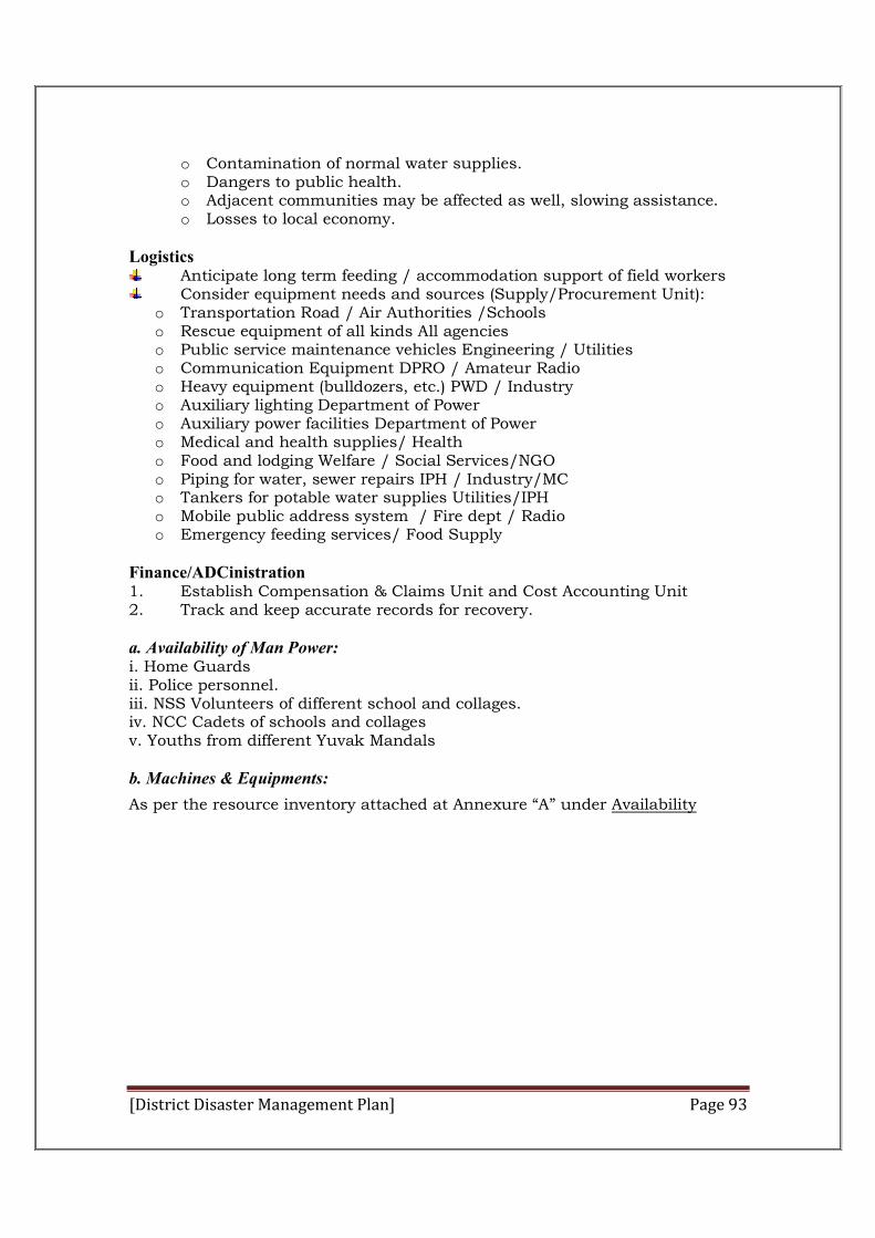
[District Disaster Management Plan] Page 93
o Contamination of normal water supplies. o Dangers to public health. o Adjacent communities may be affected as well, slowing assistance. o Losses to local economy.
Logistics Anticipate long term feeding / accommodation support of field workers Consider equipment needs and sources (Supply/Procurement Unit): o Transportation Road / Air Authorities /Schools o Rescue equipment of all kinds All agencies o Public service maintenance vehicles Engineering / Utilities o Communication Equipment DPRO / Amateur Radio o Heavy equipment (bulldozers, etc.) PWD / Industry o Auxiliary lighting Department of Power o Auxiliary power facilities Department of Power o Medical and health supplies/ Health o Food and lodging Welfare / Social Services/NGO o Piping for water, sewer repairs IPH / Industry/MC o Tankers for potable water supplies Utilities/IPH o Mobile public address system / Fire dept / Radio o Emergency feeding services/ Food Supply
Finance/ADCinistration 1. Establish Compensation & Claims Unit and Cost Accounting Unit 2. Track and keep accurate records for recovery. a. Availability of Man Power: i. Home Guards ii. Police personnel. iii. NSS Volunteers of different school and collages. iv. NCC Cadets of schools and collages v. Youths from different Yuvak Mandals
b. Machines & Equipments:
As per the resource inventory attached at Annexure “A” under Availability
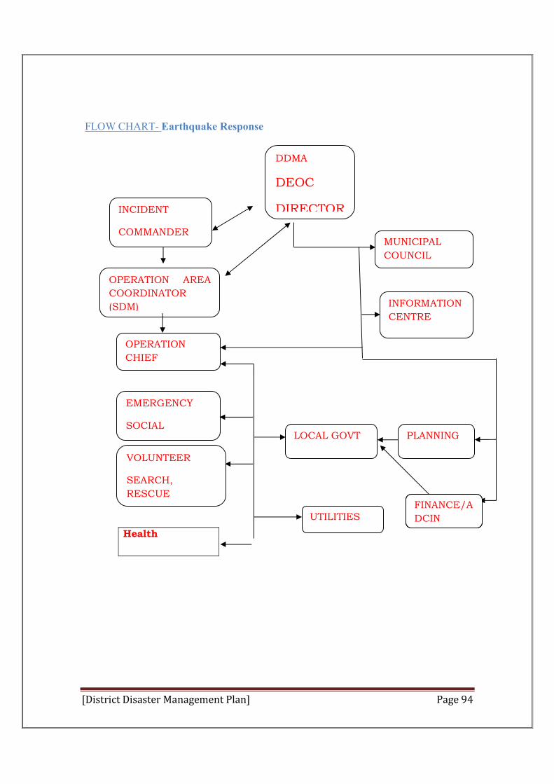
[District Disaster Management Plan] Page 94
FLOW CHART- Earthquake Response
Health
INCIDENT
COMMANDER
OPERATION AREA
COORDINATOR
(SDM)
MUNICIPAL
COUNCIL
INFORMATION
CENTRE
OPERATION
CHIEF
EMERGENCY
SOCIAL
SERVICES
VOLUNTEER
SEARCH,
RESCUE
LOCAL GOVT
PRI ETC.
PLANNING
DDMA
DEOC
DIRECTOR
UTILITIES FINANCE/A
DCIN
FINANCE/A
DCIN
FINANCE/A
DCIN
[District Disaster Management Plan] Page 95
Landslide, Debris Flow, and Subsidence.
In case of a landslide:
Possible Major Effects 1. Casualties. 2. Deaths. 3. Trapped people. 4. Damage to property. 5. Material damage - roads and bridges, utilities, buildings. 6. Flooding. 7. Panic. 8. Dangers to public health. 9. Removal of population and livestock. 10. Disruption of traffic and communications.
Policies
Regardless of where the incident occurs, responder safety will be considered first.
Hazard Specific Checklists
DEOC Director
Activate DEOC.
Ensure members of DDMA are contacted and asked to assemble at headquarter.
Establish adequate communications and news release systems (District Information Officer).
Establish public inquiry system (District Information Officer). Establish proper jurisdiction. Notify adjacent municipalities to as required.
Operations
Coordinate search and rescue of victims (Fire & Rescue Branch). Staff PR positions for possible reception centers (DPRO). Evacuate personnel, (Police Branch). Evacuate livestock (Agriculture, and Revenue). Establish traffic control (Police Branch). Protect property and relocate resources where necessary (Revenue and
Police department). Coordinate removal and disposal of slide material as required (Public
Works). Eliminate hazards from damaged utilities (Public Works).
[District Disaster Management Plan] Page 96
Planning
Deploy field observers to gather damage intelligence as soon as possible (Situation Assessment Unit).
To consider further slide potential, obtain current meteorological data. Consider possible major effects (Long-Term Planning Unit):
o Damage to property. o Closure of roads and highways. o Damage to utilities and communication systems. o Contamination of normal water supplies. o Evacuation of population from danger areas. o Dangers to public health. o Possible convergence of families and friends to help with search. o Disruption of community. o Losses to local economy. o Casuality
Logistics
Identify additional heavy equipment in anticipation of field requests (PWD). Anticipate long term feeding / accommodation support of field workers.
(DFSC) Consider equipment needs and sources:
o Transportation Road / Air Authorities o Communication Equipment o Heavy equipment (bulldozers, etc.) PWD / Industry o Auxiliary lighting Power / Utilities o Auxiliary power facilities Power / Utilities o Medical and health supplies, Health o Food and lodging ,DFSC, Revenue Finance/Administration
Establish Compensation & Claims Unit and Cost Accounting Unit. Track and keep accurate records for recovery from field.
Flood
Minor Flooding – is defined as a flooding incident that involves a single or small number of dwellings in a small geographical area. Minor flood events would normally be handled by the appropriate response agency, and are confined to a single jurisdiction. In case of a minor flood:
Possible Major Effects 1. Property damage. 2. Evacuations. 3. Damage to sewer and drainage systems.
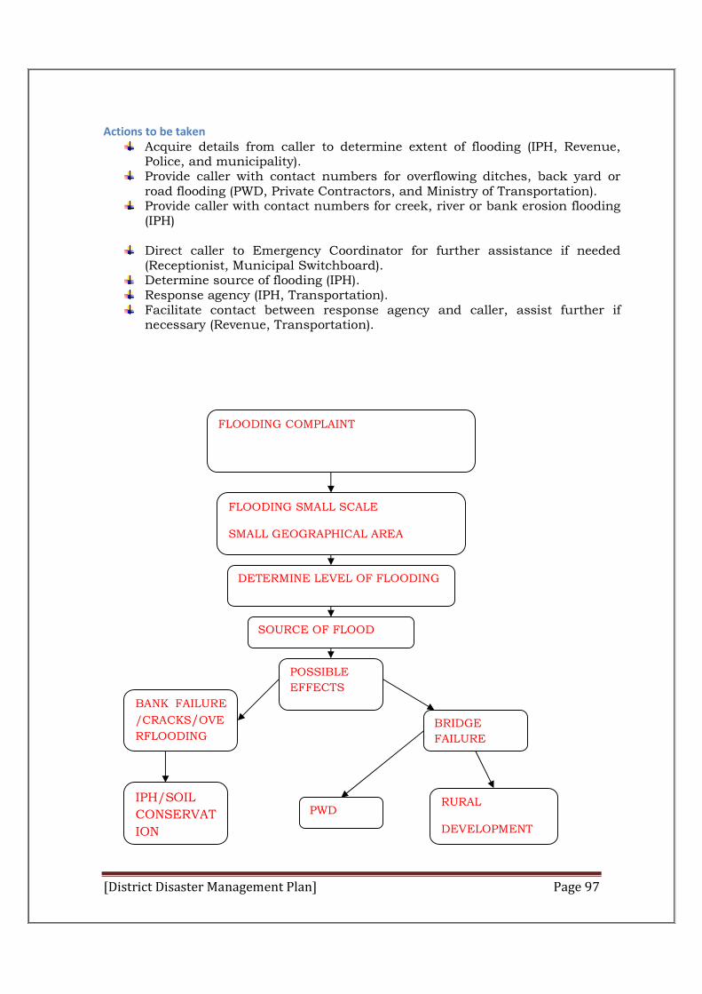
[District Disaster Management Plan] Page 97
Actions to be taken Acquire details from caller to determine extent of flooding (IPH, Revenue,
Police, and municipality). Provide caller with contact numbers for overflowing ditches, back yard or
road flooding (PWD, Private Contractors, and Ministry of Transportation). Provide caller with contact numbers for creek, river or bank erosion flooding
(IPH)
Direct caller to Emergency Coordinator for further assistance if needed (Receptionist, Municipal Switchboard).
Determine source of flooding (IPH). Response agency (IPH, Transportation). Facilitate contact between response agency and caller, assist further if
necessary (Revenue, Transportation).
FLOODING COMPLAINT
FLOODING SMALL SCALE
SMALL GEOGRAPHICAL AREA
DETERMINE LEVEL OF FLOODING
SOURCE OF FLOOD
BANK FAILURE
/CRACKS/OVE
RFLOODING BRIDGE
FAILURE
IPH/SOIL
CONSERVAT
ION
PWD RURAL
DEVELOPMENT
POSSIBLE
EFFECTS
[District Disaster Management Plan] Page 98
Fire
In case of a Forest / urban /rural fire:
Possible Major Effects:
1. Casualties. 2. Deaths. 3. Evacuation. 4. Trapped People. 5. Disruption of Traffic. 6. Disruption of Utilities. 7. Property damage. 8. Public Health Issues and Concerns.
Policies
Interface fires will be managed using unified command with Incident Commanders supplied by DFO and the Fire Department.
Hazard Specific Checklists
DEOC Director
1. Establish link with Incident Commander and EOC 2. Ensure fire command is unified 3. Alert DPRO 4. Establish news release system ( DPRO) 5. Establish public inquiry system (DPRO) 6. Establish proper jurisdiction (Emergency Coordinator) 7. Notify adjacent municipalities.
Operations
Establish communication link with Incident Commander. Determine need for evacuation through Fire Chief or declaration (Fire &
Rescue Department). Warn of potential spread of fire and need for fire breaks (Fire & Rescue
Branch). Evacuate personnel, (Police Branch). Evacuate livestock (Ministry of Agriculture). Define working area and establish control perimeter (Police). Secure ignition start area for subsequent investigation (Police). Establish traffic control and routes for emergency vehicles (Police). Protect property and relocate resources where necessary (Police). Eliminate hazards from damaged utilities (PWD /IPH/Power). Notify hospitals of casualties (Ambulance Service-108). Establish emergency public health facilities (Health Branch). Establish temporary morgue, if needed (Police Branch, Revenue). Arrange security in evacuated areas. Activate reception centre(s). Establish Family Reunification function. Determine supplementary water needs and access (IPH). Assist public with smoke induced respiratory distress (Ministry of Health).
[District Disaster Management Plan] Page 99
Planning
Supervise damage assessment. Consider possible major effects (Long-Term Planning Unit):
o Injuries and fatalities. o Fire. o Damage to property. o Collapse of buildings and other structures. o Sudden hospital requirements. o Release of toxic smoke, fumes. o Disruption of traffic and communications. o Disruption of utilities. o Convergence of media, photographers, politicians. o Possible need to relocate primary EOC.
Logistics
Anticipate requests for additional supplies. Anticipate requests for food. Consider equipment needs and sources (PWD/IPH/Power):
o Fire fighting and rescue equipment Fire / PWD/IPH/Industry o Water tankers (IPH) o Auxiliary lighting Power / Utilities o Blankets and food and clothing Welfare / Social Services o Mobile public address system DPRO / Fire dept / Radio stations o Chemical response team Fire / Industry o Traffic barricades (Police)
Finance/Administration Anticipate compensation/claim. Track and keep accurate records for recovery.
Transportation Accident
In case of a major motor vehicle crash:
Possible Major Effects Casualties. Deaths. Fires and explosions. Trapped persons. Disruption of traffic. Dangers to public health. Convergence. Possible mass casualties for buses. Dangerous goods spill.
Policies
All major motor vehicle crashes should be managed at the scene.
[District Disaster Management Plan] Page 100
The EOC will provide support and assistance to the Incident Commander as needed or requested. Hazard Specific Checklists
DEOC Director
Establish an Incident Command Post. Activate EOC as required (Emergency Coordinator etc. appointed). Make contact with motor carrier and request attendance at EOC. Establish news release system (DPRO). Establish family inquiry system (DPRO). Establish adequate communications. (BSNL) Support Incident Commander in defining working area, establishing
control perimeter, and securing the scene for subsequent investigation (Police Branch).
Notify adjacent municipalities as required.
Operations Establish routes for emergency vehicles (Police Branch). Request ambulance, wreckers, fire trucks and heavy equipment, as needed. Establish traffic and crowd control (Police Branch). Notify hospitals of casualties, including number and type (Ambulance
Service-108). Eliminate hazards from damaged utilities ((PWD /IPH/Power). Request additional police assistance (Police Branch). Establish a Reception and Information Centre (DPRO / Red Cross). Establish routes for emergency vehicles (Police Branch). Establish temporary morgue (Police Branch). Request additional buses (HRTC, Private Transportation). Request additional ambulance, heavy equipment, wreckers, and specialized
equipment as required (Police Branch). Organize rescue parties as required (Fire Rescue). Arrange temporary reception area for casualties (Health, Ambulance). Dispatch ambulances for proper distribution of casualties (Health,
Ambulance). Define a working area and establish a control perimeter (Fire Rescue). Restrict entrance to work area if hazardous or radioactive materials involved
(Police Branch, Ministry of Science, and Environment). Secure and protect property (Police Branch).
Planning Consider possible major effects (Long-Term Planning Unit):
o Injuries and fatalities. o Fire. o Explosion. o Trapped passengers. o Damage to property. o Involvement of dangerous goods, e.g., fuels. o Sudden hospital requirements. o Disruption of traffic and communications.
[District Disaster Management Plan] Page 101
o Convergence of media, photographers, politicians. o Convergence of friends and family members and need for grieving.
Logistics Prepare to support long-term recovery and investigation operations. Identify potential temporary morgue facilities (Health, Revenue). Consider equipment needs and sources (PWD /IPH/Power):
o Fire fighting and rescue equipment, Fire o Ambulances , Health o Communication equipment o Auxiliary lighting Power o Traffic barricades Police o Mobile public address system DPRO/Radio Station o Chemical response team Fire / Industry o Relief transportation Private Industry o Heavy recovery equipment PWD, Private Industry o Cutting torches PWD /IPH/Power, Private Industry o Specialized equipment to deal with radioactive material Fire Rescue /
Industry / Ministry of Environment o Emergency feeding facilities DFSC
Finance/Administration Prepare to track expenditures. Track and keep accurate records for recovery from Transport Company
(HRTC) and/or insurer. In the aftermath of disasters the affected people must be looked after for their safety, security and the well being and provided food, water, shelter, clothing, medical care etc. so as to ensure that the affected people live with dignity. DDMA shall be responsible for providing prompt and adequate relief assistance to the victims of disasters. The minimum standards of relief shall be laid down by the NDMA and by the SDMAs in terms of sections 12 and 19 respectively.
[District Disaster Management Plan] Page 102
Chapter-VII
Standard Operating Procedures for Responsible (SOPs) A standard operating procedure is “a set of instructions constituting a
directive that establishes a standard course of action.” Standard operating
procedures or SOPs, clearly spell out what is expected and required of peg a
disaster simultaneously sets into motion required prevention and mitigation
measures with minimum loss of time. Operation of Trigger Mechanism requires
clear delineation of duties & functions including identification of key personnel.
Adequate delegation to act in the first critical 24-28 hours without loss of time
in planning or seeking clearance/ approval/ direction from superiors is sought.
Standard Operating Procedures (SOPs) are required to be evolved in meticulous
detail for effective operation of the Trigger Mechanism.
The objectives of the SOPs (a) To provide, in a concise and convenient form, a list of major executive
actions involved in responding to natural disasters and necessary measures for preparedness, response and relief required to be taken;
(b) To ensure that all concerned Departments and Organisations of the District ADCinistrations know the precise measures required of them at each stage of the process and also to ensure that all actions are closely and continuously coordinated;
(c) To indicate various actions this would be required by the District ADCinistration within its sphere of responsibilities so that it may prepare and review the Contingency Action Plans accordingly.
Department of Revenue and Relief Department hasdesignated one Nodal Officer of the department. She/he
willmaintain contact with forecasting agencies and gather all possible
information regarding the alert. She/he willorganise survey of buildings and
installations for using as shelters/relief centres during disaster times. She/he
will ensure that structural and non-structural mitigation measures are taken
by all its department offices. She/he will ensure activation of District
Emergency Operation Centre (DEOC) in standby mode and in full form. She/he
willinstruct all ESFs to remain in readiness for responding to the emergency
and will coordinate and plan all activities with the ESFs. She/he will advice
District collector to carry out evacuations where required, and to keep
transport, relief and medical teams ready to move to the affected areas at a
short notice. She/he will conduct Rapid Assessment and launch Quick
Response. She/he will conduct survey in affected areas and assess
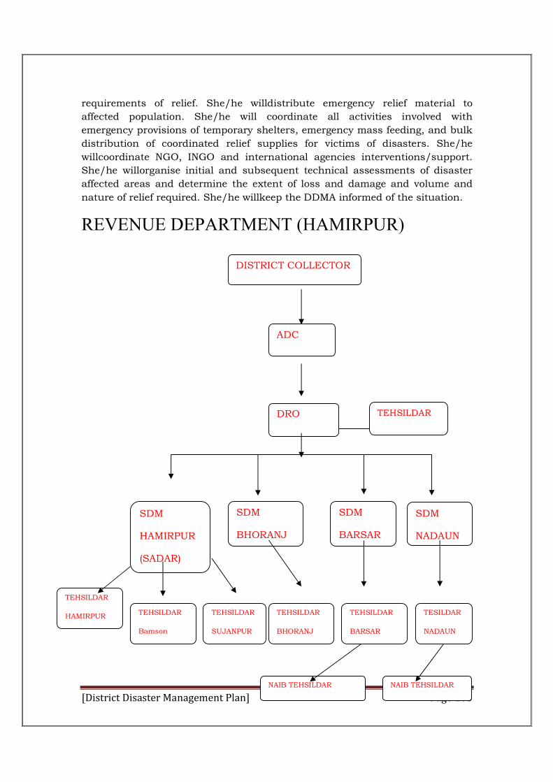
[District Disaster Management Plan] Page 103
requirements of relief. She/he willdistribute emergency relief material to
affected population. She/he will coordinate all activities involved with
emergency provisions of temporary shelters, emergency mass feeding, and bulk
distribution of coordinated relief supplies for victims of disasters. She/he
willcoordinate NGO, INGO and international agencies interventions/support.
She/he willorganise initial and subsequent technical assessments of disaster
affected areas and determine the extent of loss and damage and volume and
nature of relief required. She/he willkeep the DDMA informed of the situation.
REVENUE DEPARTMENT (HAMIRPUR)
DISTRICT COLLECTOR
ADC
SDM
HAMIRPUR
(SADAR)
SDM
BHORANJ
SDM
NADAUN
SDM
BARSAR
DRO
TEHSILDAR
SUJANPUR
TEHSILDAR
Bamson
TEHSILDAR
BHORANJ
TEHSILDAR
BARSAR
TESILDAR
NADAUN
NAIB TEHSILDAR NAIB TEHSILDAR
TEHSILDAR
(RECOVERY)
TEHSILDAR
HAMIRPUR
[District Disaster Management Plan] Page 104
Figure 8: Revenue Department structure
Department hasdesignated one Nodal Officer of the department Shri Phone No.
224757 Mobile No. 9418467267
She/he willmaintain contact with forecasting agencies and gather all possible
information regarding the alert. She/he willorganise survey of buildings and
installations for using as shelters/relief centres during disaster times. She/he
will ensure that structural and non-structural mitigation measures are taken
by all its department offices. She/he will ensure activation of District
Emergency Operation Centre (DEOC) in standby mode and in full form. She/he
willinstruct all ESFs to remain in readiness for responding to the emergency
and will coordinate and plan all activities with the ESFs. She/he will advice
District collector to carry out evacuations where required, and to keep
transport, relief and medical teams ready to move to the affected areas at a
short notice. She/he will conduct Rapid Assessment and launch Quick
Response. She/he will conduct survey in affected areas and assess
requirements of relief. She/he willdistribute emergency relief material to
affected population. She/he will coordinate all activities involved with
emergency provisions of temporary shelters, emergency mass feeding, and bulk
distribution of coordinated relief supplies for victims of disasters. She/he
willcoordinate NGO, INGO and international agencies interventions/support.
She/he willorganise initial and subsequent technical assessments of disaster
affected areas and determine the extent of loss and damage and volume and
nature of relief required. She/he willkeep the DDMA informed of the situation.
She/he will ensure supply of food, drinking water, medical supplies and other
emergency items to the affected population.
Police Department
Police Department hasdesignated one nodal Officer in the department.
(see annexure)
In Hamirpur District Police Department has an important role of providing
security, logistics, and if necessary, assistance in distribution of relief items and
provision of equipment for emergency response. . It will prepare an operational
Plan for responding to any type of disaster.
Police Department willestablish, maintain and train district search and rescue
response team. It will impart training to the members of Police Force in first aid,
evacuation, rescue and relief operations. It will conduct Search and Rescue
training to local volunteers. It will prepare an inventory of all man power and
equipment available. It will prepare an inventory of volunteers who have already
completed training courses successfully and can be utilized in the search and
[District Disaster Management Plan] Page 105
rescue operations. It willidentify the 'High Risk' and 'Risk' areas for different
disasters and instruct the existing police installations located in those areas for
keeping themselves in readiness for undertaking emergency rescue, evacuation
relief operations. It willarrange drills for fire extinguishing, rescue, evacuation
and transportation of injured persons and prepare coordinated Action Plans in
cooperation with District ADCinistration and concerned local agencies. It
willhold annual drills on disaster preparedness and response. It will maintain
communications with the police installations in the areas likely to be affected by
disaster. It willinform nearest police station (from the likely disaster affected
area) for dissemination of warning. It willinstruct all concerned to accord
priority to disaster related wireless messages if required by appropriate
officials.On receipt of directives from the DEOC for evacuation - organize
personnel and equipment for evacuation and undertake evacuation operations.
It will earmark a reserve task force, if needed. It willmove task forces to the
convenient positions, if needed. It willcarry out search and rescue operations. .
It willcarry out fire fighting operations. It will maintain law and order,
especially during relief distribution. It will keep close watch for any criminal
and anti-state activity in the area. . It will keep direct contact with different
officers like District EOC for taking any steps to combat any situation. . It
willdispatch situation reports to the DEOC.
It willassist local ADCinistration in removing the dead bodies and debris in
affected area. It will arrange security of government property and installations
damaged in a disaster. It will coordinate with other offices for traffic
management in and around damaged areas. It will assist the local
ADCinistration in putting a stop to theft and misuse in relief operation.
Department of Transport
Department hasdesignated one Nodal Officer of the department Sh.
Pardeep Singh , Regional Manager HRTC Hamirpur Phone No. 01972222326
During preparedness stage department willdevelop a disaster management
plan. It will carry out survey of condition of all highway systems at state and
district level. It will carry out survey of condition of all aircraft landing facilities.
It willidentify transport vehicles available and ensure that they are all in good
working condition. It willensure availability of fuel, recovery vehicles and
equipment. It willtake steps for arrangement of vehicles for possible evacuation
of people during disaster situations, the department would need to take steps to
arrange for sending personnel and relief material to the disaster affected area,
relocate the affected people, keep access routes operational and inform about
alternate routes.
During emergency it will remain in contact with the DEOC and will take steps
for transportation of relief personnel and material to affected areas. It willtake
steps for movement of affected population to safer areas. It will disseminate
[District Disaster Management Plan] Page 106
information regarding operational and safe routes and alternative routes; fuel
availability etc. to personnel operating in the field. It willlaunch recovery
missions for stranded vehicles. It willlaunch repair missions for damaged
critical infrastructure and routes. During recovery and rehabilitation time, it
will assess damage to transportation infrastructure and will take steps to
ensure speedy repair and restoration of transport links.
Department of Public Works
It hasdesignated one Nodal Officer in the department (see annexure)
The Department of Public Works has a vital role in provision and maintenance
of vital public infrastructure. During preparedness time department willtake
precautionary steps for the protection of government property against possible
loss and damage during disaster. It willformulate guidelines for safe
construction of public works. It willprepare list, with specifications and
position, of heavy construction equipment in Hamirpur district.It will organize
periodic training of engineers and other construction personnel on disaster
resistant construction technologies. It will actively work to develop a
sustainable state-wide hazard mitigation strategy. It will be responsible for
repair, Maintenance and retrofitting of public infrastructure. Identify / prioritize
mitigation activities of lifeline buildings and critical infrastructure and
coordinate with the DDMA members for its implementation.
In Alert and Warning Stage it willinstruct all officials at construction sites to
keep manpower and materials prepared for protection and repair of public
works. It will direct construction authorities and companies to preposition
necessary workers and materials in or near areas likely to be affected by
disaster. It will get vehicles inspected, fuel tanks filled and batteries and
electrical wiring covered as necessary. It will ensure thatextra transport vehicles
should be dispatched from headquarters and stationed at safe strategic spots
along routes likely to be affected. It willinspect all roads, road bridges by a
bridge engineer, including underwater inspection of foundations and piers. A
full check should be made on all concrete and steel works. It willinspect all
buildings and structures of the state government (including hospital buildings)
by a senior engineer and identify structures which are endangered by the
impending disaster. The designation of routes strategic to evacuation and relief
should be identified and marked, in close coordination with police and district
control room. It will establish a priority listing of roads which will be opened
first. Among the most important are the roads to hospitals and main trunk
routes. It willgive priority attention to urgent repair works that need to be
undertaken in disaster affected areas.Work under construction should be
secured with ropes, sandbags, and covered with tarpaulins if necessary.
Emergency inspection by mechanical engineer of all equipments in the district
workshops should be done.If people are evacuating an area, the evacuation
[District Disaster Management Plan] Page 107
routes should be checked and people be assisted. The locations for setting up
transit and relief camps, feeding centres should be identified and DEOC should
be informed accordingly.
During disaster it willprovide assistance to the damage assessment
teams for survey of damage to buildings and infrastructure. Adequate road
signs should be installed to guide and assist the drivers.Casual labourers to be
assembled to work with experienced staff for clearing roads.It will mobilize
community assistance for road clearing by contacting community
organizations.It willundertake cleaning of ditches, grass cutting, burning or
removal of debris, and the cuttingof dangerous trees along the roadside in the
affected area through maintenance engineer’s staff and will undertake repair of
all paved and unpaved road surfaces including edge metalling, pothole patching
and any failure of surface, foundations in the affected areas by maintenance
engineer's staff and keep monitoring their conditions. It willundertake
construction of temporary roads to serve as access to temporary transit and
relief camps, and medical facilities for disaster victims.As per the decisions of
the District Emergency Operations Centre undertake construction of temporary
structures required, for organizing relief work and construction of relief camps,
feeding centres, medical facilities, cattle camps . It will take steps to clear debris
and assist search and rescue teams. It will provide sites for rehabilitation of
affected population. After Disaster during recovery and rehabilitation it will
carry out detailed technical assessment of damage to public works. It will assist
in construction of temporary shelters. It will organize repairs of buildings
damaged in the disaster. It will prepare detailed programs for rehabilitation of
damaged public works. It will arrange technical assistance and supervision for
reconstruction works as per request.
Department of Irrigation and Public Health
In Hamirpur district one Nodal Officer has been designated (see annexure)
The Department is involved in disaster mitigation in relation to drought
and floods, as they affect agricultural production, irrigation systems and water
supply and management. Some of these mitigation activities include
rehabilitation and management of watersheds and water catchment areas and
enforcement of land use patterns. This role is critical for improving and
expanding irrigation systems to cope with drought situations and manage flood
problems.
During preparedness time department will ensure efficient management
of flood forecasting and warning centres and improve procedure of flood
forecasts and intimation to appropriate authorities.
It willidentify flood prone rivers and areas and activate flood monitoring
mechanisms in all flood
[District Disaster Management Plan] Page 108
prone areas. It willoperate Flood Information Centre in the flood season every
year. It will inform all concerned about daily weather news and issue regular
press bulletins. It willtake steps for strengthening of flood protection works
before the flood season. It will make departmental mitigation plan and ensure
its implementation. In the stage of alert and warning it will alert DEOC. Since
flash floods get triggered within short time-spans, take steps to alert all though
telephone and wireless according to needs.
During Disaster it will be responsible fortransportation of water with
minimum wastage (in coordination with the transport department. It willidentify
and mark damaged water pipelines and contaminated water bodies and inform
disaster victims against using them.
During recovery and rehabilitation it will carry out Environmental Impact
Assessment of the disaster. It will take up sustained programs for rehabilitation
of flood protection works.
Department of Agriculture
In Hamirpur district one Nodal Officer has been designated. (see annexure)
This department has a role in assessment of damage to agricultural
crops, and impact of possible locust attacks. Its main role is to provide seeds
and necessary planting material and other inputs to assist in early recovery.
During preparedness timeidentify areas likely to be affected andorganize
distribution of seeds, seedlings, fertilizer and implements to the affected people
under loan/grant.Arrange for keeping stock of seeds, fertilizers and pesticides.
During warning stage, it should check available stocks of equipments
and materials which are likely to be most needed after the disaster. It should
stock agricultural equipments which may be required after a disaster. it should
determine what damage, pests or diseases may be expected, and what drugs
and other insecticide items will be required, in addition to requirements of
setting up extension teams for crop protection, and accordingly ensure that
extra supplies and materials, be obtained it quickly. It should provide
information to all concerned, about disasters, likely damages to crops and
plantations, and information about ways to protect the same.
During disaster it willmonitor damage to crops and identify steps for
early recovery. It willestimate the requirement of Seeds, Fertilizers Pesticides,
and Labour. It shouldorganise transport, storage and distribution of the above
with adequate record keeping procedures. It shouldensure that adequate
conditions through cleaning operations are maintained to avoid water-logging
and salinity.A pests and disease monitoring system should be developed to
ensure that a full picture of risks is maintained.
[District Disaster Management Plan] Page 109
After disaster it willquantify the loss and damage within the quickest
possible time and finalizes planning of agriculture rehabilitation. It will also
ensure availability of adequate supply of seeds, seedlings, fertilizers, pesticides
and agricultural implements. It will assist farmers to re-establish their contacts
with agriculture produce market and ensure that appropriate prices be offered
to them.
Department of Animal Husbandry
In Hamirpur district one Nodal Officer has been designated (see
annexure)
The Department of Animal Husbandry has responsibility towards mitigation
prevention of suffering of livestock during disaster, prevention of any animal
epidemic, zoonetic disease epidemic, fodder assessment and management
during disaster after coordination with DDMA through DEOC (District
Emergency Operation Centre).
During preparedness stage it will identify disaster prone areas, livestock
population at risk, requirement of medicine, vaccines, equipments,
disinfectants and other materials material require any material during disaster
in prone area.
During warning stage it will check available stocks of equipments and
materials which are likely to be most needed after the disaster.
It will stock Veterinary equipments which may be required after a disaster. It
shoulddetermine what damage, pests or diseases may be expected, and what
drugs and other insecticide items will be required, in addition to requirements
of setting up extension teams for animal protection, and accordingly ensure
that extra supplies and materials, be obtained quickly.
During disaster it willrush Rapid Assessment Team to Incident site to
assess the quantum of damage and immediate requirement for relief and rescue
to share with DEOC. It will rush quick team along with the needed medicines
equipments and other materials for relief and rescue operation at disaster site
to minimize further loss and damage. It willarrange for quick and proper
disposal of carcasses with disinfection of the premises with the help of local
people, other line department by coordination of DOEC to check spread
epidemic. It will take immediate preventive measures like quarantine,
immunization and culling etc. as per requirement of the situation.
After disaster it will quantify the loss and damage within the quickest
possible time and finalizes planning for rehabilitation. It will coordinate with
revenue Department to ensure relief distribution as per direction of the State
Govt. / already laid down norms by the Govt.
[District Disaster Management Plan] Page 110
Department of Education
In Hamirpur district one Nodal Officer has been designated (see annexure)
The department will prepare curriculum related to disaster management
and conduct training programme for teachers and children. The department will
coordinate with the local authority and arrange for mock drills, search and
rescue drills.
During preparedness in consultation with DDMA, include disaster related
subjects in the curricula in schools, and colleges. It willarrange for training of
teachers and students of disaster prone areas about the steps to be taken at
different stages of disaster and organise them, in coordination with volunteers
and inspire them for rescue, evacuation and relief works. It will ensure that all
schools and colleges develop their disaster management plans. It will ensure
that construction of all educational institutions in earthquake zones is
earthquake resistant.
During Alert and Warning Stage identify structural and non structural
mitigation measures.
It willin coordination with the SSA and/or Public works department assess
schools and colleges buildings conditions. It willmake departmental mitigation
plan and ensure its implementation. It willensure that earthquake resistant
features are included in new school buildings.
During response it will place required number of education institutions and
their buildings, under the DEOC for use as emergency shelter and relief centre
if necessary.Students and staff can provide local voluntary assistance for
distribution of relief material and assistance to special needy people in the
locality.
During recovery and rehabilitation it will determine the extent of loss in
educational institutions and prepare plans for their rehabilitation.
Department of Technical Education and vocational training
The department will play a vital role in the State mitigation strategy. Its main
role will be to conduct training programs to the construction workers, involved
at the community level. It will encourage disaster resistant technological
practices in buildings and infrastructure.It will encourage the people in
earthquake prone areas to adopt earthquake resistant technologies. It will in
coordination with PWD conduct regular training to the engineers of the
department. It will arrange for training programs and certificate course of
construction workers. It will prepare a disaster management plan for the
department. It will prepare an inventory of volunteers who have already
completed training courses successfully and can be utilized in implementation
[District Disaster Management Plan] Page 111
of mitigation measures and new construction. During response, recovery and
rehabilitation, it willcoordinate with DDMA.
Department of Rural Development
In Hamirpur district one Nodal Officer has been designated(see annexure)
Department of Rural development is one of the main departments that have the
mandate to implement vulnerability reduction projects to alleviate poverty and
improve people’s livelihoods.
During preparedness it willprepare maps showing population concentration and
distribution of resources. It willalert all concerned about impending disaster. It
will ensure safety of establishments, structures and equipment in the field. It
will ensure formation of committee for rescue, relief and rehabilitation work and
local volunteer teams.
During response it will ensure information flow from affected block and
maintain regular contact with DEOC (24 hrs). It will ensure availability of
drinking water at times of need. It will provide necessary infrastructure to carry
out relief works. It will assess initial damage
During recovery and rehabilitation it will quantify the loss/damage. It will
organise reconstruction of damaged houses on self help basis with local assets
and materials received from the government. It will take up
repair/reconstruction work of infrastructure damaged by disaster.
Department of Health
In Hamirpur district one Nodal Officer has been designated(see annexure)
The department of Health has a responsibility in the reduction and prevention
of suffering during natural and man-made disasters.The emergency department
is responsible for prevention and response of natural disasters and man-made
disasters, as well as in the investigation and response to outbreak of
communicable diseases.During preparedness stage it will develop a plan on
emergency preparedness and response within the health sector. It willcarry out
and disseminate a risk evaluation of the population. It will ensure disaster
management plans are developed in health centres and hospitals. It will ensure
that all hospital staff has been informed about the possible disasters in the
district, likely damages and effects, and information about ways to protect life,
equipment and property. It will ensure that orientation and training for disaster
response plans and procedures are undertaken. Special skills required during
disaster situations are imparted to the officials and the staff. It will ensure
adequate availability of Emergency Health Kits in high risk areas. It willtrain
volunteers on emergency preparedness programmes such as first aid and
preventive measure against diseases in disaster prone areas. It willprepare a list
of medical and Para-medical personnel in disaster prone areas and disseminate
[District Disaster Management Plan] Page 112
it to concerned governors and ADCinistrators. It will establish and operate an
early warning system for health threats based on the routine health information
and in collaboration with other departments.In Alert and Warning Stage it will
conduct damage assessment of hospital infrastructure and request of medical
equipment required. It will prepare and keep ready Mobile Hospitals and stock
them with emergency equipment that may be required after the disaster. It will
assess likely health impacts and share with DEOC for planning purpose. It will
ensure pre-positioning of Emergency Health Kits and Personnel. It will direct
the activation of health/medical personnel, supplies and equipment as
required.During disaster it will mobilise medical teams and Para-medical
personnel to go to the affected areas as part of the Rapid Assessment and Quick
Response Teams. It will provide medical assistance to the affected population. It
will provide chlorine tablets to people in affected area. It will take special care
for women with infants and pregnant women. It will carry out technical
assessment on health infrastructure availability and need.
Forest Department
In Hamirpur district one Nodal Officer has been designated (see annexure)
During preparedness stage it will prepare a department disaster management
plan. It will identifyforest fire prone areas and extra vigilance be ensured in
such cases. It willorganise community awareness programs. It will prepare and
maintain forest lines. It will prepare mitigation plan for the department
buildings and infrastructure.In Alert and Warning Stage it will establish a rapid
response team at division/sub-division level, which will have all tools and
equipments readily available.During response it will respond in accordance with
department disaster management planAfter Disaster it will preparedamage
assessment report and share it with DEOC.
Department of Urban Development
In Hamirpur district one Nodal Officer has been designated (see annexure)
In preparedness stage it will develop a disaster management plan for the
department, including the identification of location of camps for different type of
disasters, existing locations that can be used as shelters, inventories of
agencies that can be used for tent establishment. It will conduct regular
training the staff on minimum standards for shelter, relief camps and tent
structures.
In mitigation stage it will coordinate with the DDMA members for
implementation of mitigation activities in the urban areas.
In Alert and Warning Stage it will locate adequate relief camps based on
prediction of damage.Quick assessment of functional and stable building
structures will be done by this department. It willclear areas for setting up relief
[District Disaster Management Plan] Page 113
camps. In case of damage to offices, it will assist local authorities to establish
and house important telecom equipment and officials at the earliest
It will develop alternative arrangements for population living in structures that
might be affected after the disaster. It will setting up water point in key
locations and in relief camps
In the response stage it will locate relief camps close to open traffic and
transport links. It will set up relief camps and tents using innovative methods
that save time. It will provide adequate and appropriate shelter to the entire
population. It will coordinate with other ESFs in equipping shelter and relief
sites with basic needs of communication and sanitation. It will help in
maintaining and providing clean water and also procurement of clean drinking
water. It will coordinate with DEOC for proper disposal of dead bodies in the
urban areas.
During recovery and rehabilitation stage it will implement recovery and
rehabilitation schemes through municipalities for urban areas.
Department of Food, civil supplies and consumer affairs
In Hamirpur district one Nodal Officer has been designated (see annexure)
The department will be mainly responsible for identifying the basic needs of
food in the aftermath of a disaster or emergency, to obtain appropriate supplies
and transporting such supplies to the disaster area.
In preparedness stage it will develop a disaster management plan for the
department, through this plan it will ensure timely distribution of food to the
affected population. It will ensure maintaining a stock of food relief items for
any emergency.
During Alert and Warning Stage it will determine the critical need of food for the
affected area. It will prepare a catalogue of available resources of food. It will
ensure that food distributed is fit for human consumption and also ensure
quality and control the type of food. It will allocate food in different packs that
can be given to families on a taken home basis while others that can be
distributed in relief camps
During disaster it will coordinate with local authorities and other ESFs to
determine requirements of food for affected population. It will mobilise and
coordinate with other ESFs for air dropping of food to affected site. It will
prepare separate food packs for relief camps as well as large quantity
containers. It will control the quality and quantity of food that is distributed to
the affected population.
[District Disaster Management Plan] Page 114
It will ensure that special care in food distribution is taken for women with
infants, pregnant women and children.
After disaster it will establish PDS points as per the changed
scenario/resettlements (If any). It will alsoissue duplicate ration cards to the
disaster victims, who lost their papers.
Department of PanchayatiRaj
In Hamirpur district one Nodal Officer has been designated (see annexure)
During preparedness stage prepares a department disaster management plan
update it annually. It will analyse the training needs of the department’s
personnel, which include its officials and elected representatives of Gram
panchayat, panchayat samiti’s and zila panchayat and organise trainings with
the help of HIDM or other agencies. It will conduct gram panchayat level mock
drills as part of preparedness.During disaster it will coordinate with local
authorities and support the response efforts also it will coordinate the support
from unaffected gram panchayats.After disaster it will ensure proper
distribution of reconstruction schemes and monitoring of the same during
Block development committee and zila parishad meetings.
Department of Information and Public Relations
In Hamirpur district one Nodal Officer has been designated (see annexure)
The Department has to play a major role in education and awareness
programmes for better organized preparedness and response at government and
community levels. It also plays a main role to collect reliable information on the
status of the disaster and disaster victims for effective coordination of relief
work at District level.
In preparedness stage it will develop a disaster management plan for the
department. It will conduct education and awareness for local community. It
will popularize the techniques for preparedness and survival during pre-
disaster, disaster and post-disaster period through television, radio and other
publicity media. It will ensure strict performance of the allotted duties by radio,
television, news media, films and publications related departments. It will take
proper and adequate security steps for the protection of own installations and
properties. It will prepare guidelines / policy for necessary action by mass
media on reporting disasters. During Alert and Warning Stage, it will acquire
accurate scientific information from the Scientific and technology department. It
will flash warning signals on all TV and radio networks. Disseminate
information to all victims in the affected area. It will take measures to curb the
spread of rumours. It will caution the victims about the do’s and don’ts during
a disaster.During disaster it will coordinate with the EOCs for required
information for relief workers. It will provide information of emergency numbers

[District Disaster Management Plan] Page 115
and other key contact numbers on television, through newspapers,
loudspeakers and radio networks. It will send news flashes of latest updates /
donation requirements for disaster area. It will ensure that the news to be
broadcasted reflects the true and clear presentation of the actual position and
does not create panic in the minds of the people and also advises them to desist
from taking unreasonable steps. It will take steps for publicity of news and
directives relating to the situation issued by the DDMA. It will curtail normal
programmes to broadcast essential information on disaster if requested by the
EOC. It will arrange visit to the affected area by the local and foreign journalists
in the interest of publication of accurate and true report in the news. It will help
victims as well as emergency workers in providing information regarding
hospitals, help desk. It will inform unaffected population about hospitals where
they can find victims and where assistance is required.After disaster it will
arrange dissemination of information of the short and long term measures of
different ministries, Departments/Agencies for relief and rehabilitation of the
affected people.
Department of Power
In Hamirpur district one Nodal Officer has been designated (see annexure)
In the preparedness stage it will develop a disaster management plan for the
department. It will carry out survey of condition of all power supply at district
level.
In the Alert and Warning Stage it will establish radio communications with the
DEOC and SEOC.It will prepare a First assessment report in conjunction with
other ESFs for the DEOC to take further decision. It will check emergency
toolkits.
During response it will establish contact with the DEOC and SEOC. It will
assist authorities to reinstate generators for public facilities such as Hospital,
water supply, police stations, telecommunication building and meteorological
stations. It will dispatch emergency repair teams equipped with tools, tents and
food. It will establish temporary electricity supplies for relief material
warehouses.
During recovery and rehabilitation: It will facilitate restoration of energy systems
after a natural /manmade disaster. It will review total extent o damage to power
supply installations. It will take steps to ensure speedy repair and restoration of
power supply installations.
District Disaster management Plan, Hamirpur
In Hamirpur district one Nodal Officer has been designated (see annexure)
In the preparedness stage it will develop a disaster management plan for the
department Non Disaster Time it will ensure all possible steps for the security
of manpower, implements, stock, installations /factories etc. It will prepare
[District Disaster Management Plan] Page 116
listing and locations of industries and establishments for possible sourcing of
relief material during disasters. It will ensure training on preparedness
programmes to be adopted at different levels for all manpower employed in
factories and establishments in disaster vulnerable areas. It will promote the
preparation of installation emergency preparedness plans by all industrial
units. It will take measures for preventing environmental disaster in chemical
industry or industries emitting toxic gases and effluents. It will issue detailed
instructions to the employees about their duties and responsibilities in
precautionary, disaster and post-disaster stages of normal disaster. It will
arrange regular training for mining employees in the disaster prone areas on
disaster issues.
During alert and Warning Stage evacuation of the mineworkers from the mines
on the receipt of early warning.
During response it will request industries to provide emergency relief material
such as food products, temporary shelter, medicines and medical equipment
and search and rescue equipment. It will provide labour to other departments
for relief supply and distribution. It will provide skilled labour for maintenance
of equipment and tools. It will help in establishment of camps. It will ensure
minimum wages to labour during relief work in drought or other disasters. It
will take steps to plan for rehabilitation of industries adversely affected by
disasters. It will issue disaster management guidelines to all the industries and
ensure on-site and offsite plans for all industries. It will prepare and
disseminate guidelines for the labour security and safety. It willprepare and
implement rules and regulations for industrial safety and hazardous waste
management. It willprepare and disseminate public awareness material related
to chemical accidents. After disaster it will take appropriate steps to provide
labour assistance to concerned departments in reconstruction and
rehabilitation programmes. It will introduce employment generation schemes
and alternate livelihoods for affected populations.
Department of Social Justice and Empowerment
In Hamirpur district one Nodal Officer has been designated (see annexure)
The department will arrange for protection of manpower and organize special
camps for the disabled, widows, children and other vulnerable groups. It will
also provide necessary help and assistance for socio-economic rehabilitation.In
the preparedness stage it will develop a disaster management plan for the
department.
Indian Red Cross and National NGOs
In Hamirpur district one Nodal Officer has been designated. (see annexure)
[District Disaster Management Plan] Page 117
The Indian Red Cross would perform the following duties within the ambit of its
own rules and regulations and organisational structure, in association with
various governmental organisations.In the preparedness stage it will take steps
for preparing community based disaster management plans.It willidentify
volunteers in disaster prone areas and arrange for their training. It will organise
awareness raising programs, seminars and meetings with the people for
improving their capacity to face disasters.It willmaintain contacts with District
ADCinistrators on its activities. It will ensure road communication and pre-
positioning of relief material as close as possible to disaster prone communities.
In Hamirpur district one Nodal Officer has been designated. (see annexure)
It willarrange for the necessary funds as per decision of the State
Government/DDMA during disaster. It will ensure quick allocation of funds for
meeting relief operations. It will control all accounts under the responsibility of
the Government. It will start mobilizing resources for construction of
infrastructure, public facilities and structures required for recovery.
After disaster it will allocate and monitor government plan expenditure towards
relief and rehabilitation of disaster affected areas.
In Alert and Warning Stage it will issue warning notice to all concerned. It will
keep the survey and relief team of head quarters on stand-by in readiness with
required transport and equipment. It will mobilise volunteers and issue
instructions for sending them to potential disaster affected areas. It will take
part in evacuation programme of population with close cooperation of
volunteers. It will coordinate with pre identified NGOs for possible joint
operations.
During disaster it will ensure survey of loss and damage in affected areas and
dispatch of relief teams from concerned Red Crescent Society Units. It will
assist the Government to determine loss, damage and needs related
information.
It willgive emergency assistance to disaster affected people especially in the
following cases:
1.Help in rescue and evacuation work, temporary shelter, first aid, food and
clothing,
2.Arrange for distribution of relief material received from Red Crescent Unit of
areas not affected by disaster and from headquarters.
3.Send request for requirement of relief and rehabilitation to the International
Federation of Red Cross and Crescent Societies (IFRC) after informing about
loss and damage due to disaster.
[District Disaster Management Plan] Page 118
After disaster it will participate in reconstruction and rehabilitation
programmes in special circumstances. It will take steps for correct and effective
evaluation of preparedness work and for correcting errors/weakness in such
work. It will extend Cooperation to the district/state EOC for disaster
documentation.
THE EMERGENCY SUPPORT FUNCTIONS
Disaster response is a multi-agency function. There will be one Lead or Primary
Agency which will be responsible for managing and coordinating the response
while other agencies will support and provide assistance in managing the
incident. These ESFs will form integral part of the Emergency Operation
Centres (EOCs) and each ESF should coordinate its activities from the allocated
EOC. Extension teams and workers of each ESF will be required to coordinate
the response procedures at the disaster affected site.
Table 12: Roles and responsibilities of the ESF
ESF
Responsibilities
Transport
Provide coordination of state transport support and local government. Coordinate the use of transportation resources to support the need of emergency support forces requiring transportation capacity to perform their emergency response, recovery and assistance missions. It will works with outside agencies for transportation, coordination and preparedness resource request for assistance when needed.
Power
To facilitate restoration of energy systems after a natural disaster
CommunicationsWill ensure the provision of state wide telecommunication, support to the state, and district in response efforts
Public health andsanitation
Provide coordinated assistance to supplement state and local resources in response to public health and medical care needs following significance natural or manmade disaster. Resources will be furnished when the state and district resource are overwhelmed and medical and public health assistance is requested from the State government.
Search and Rescue
Provide specialized life saving assistance to state and local authorities. In the event of a major disaster or emergency. Its operational activities include locating, extricating and providing on site medical treatment to victims trapped in collapsed structures.
Donations
Donation management is necessary to control the flow of goods and services into a disaster area. If trucks, trains, and planes are allowed into the disaster area to draw their donations, they can easily interfere with other ongoing disaster response operation. Uncontrolled donations can also put undue burden on disaster response operations as they required scarce response resources. Above all it is necessary to manage the flow of donated gods to be sure that the needs of disaster victims are being met as effectively as possible. Expedite delivery of voluntary gods and
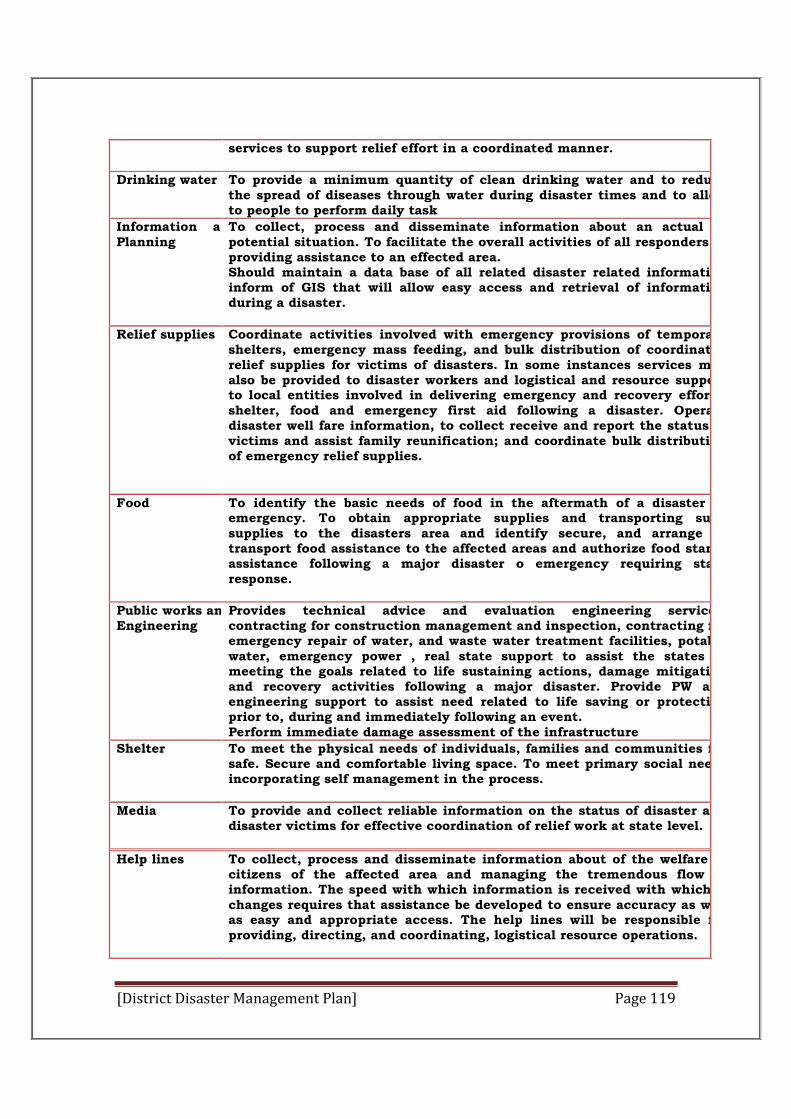
[District Disaster Management Plan] Page 119
services to support relief effort in a coordinated manner.
Drinking water
To provide a minimum quantity of clean drinking water and to reduce the spread of diseases through water during disaster times and to allow to people to perform daily task
Information and Planning
To collect, process and disseminate information about an actual or potential situation. To facilitate the overall activities of all responders in providing assistance to an effected area. Should maintain a data base of all related disaster related information inform of GIS that will allow easy access and retrieval of information during a disaster.
Relief supplies
Coordinate activities involved with emergency provisions of temporary shelters, emergency mass feeding, and bulk distribution of coordinated relief supplies for victims of disasters. In some instances services may also be provided to disaster workers and logistical and resource support to local entities involved in delivering emergency and recovery efforts, shelter, food and emergency first aid following a disaster. Operate disaster well fare information, to collect receive and report the status of victims and assist family reunification; and coordinate bulk distribution of emergency relief supplies.
Food
To identify the basic needs of food in the aftermath of a disaster or emergency. To obtain appropriate supplies and transporting such supplies to the disasters area and identify secure, and arrange to transport food assistance to the affected areas and authorize food stamp assistance following a major disaster o emergency requiring state response.
Public works andEngineering
Provides technical advice and evaluation engineering services, contracting for construction management and inspection, contracting for emergency repair of water, and waste water treatment facilities, potable water, emergency power , real state support to assist the states in meeting the goals related to life sustaining actions, damage mitigation and recovery activities following a major disaster. Provide PW and engineering support to assist need related to life saving or protecting prior to, during and immediately following an event. Perform immediate damage assessment of the infrastructure
Shelter
To meet the physical needs of individuals, families and communities for safe. Secure and comfortable living space. To meet primary social needs incorporating self management in the process.
Media
To provide and collect reliable information on the status of disaster and disaster victims for effective coordination of relief work at state level.
Help lines
To collect, process and disseminate information about of the welfare of citizens of the affected area and managing the tremendous flow of information. The speed with which information is received with which it changes requires that assistance be developed to ensure accuracy as well as easy and appropriate access. The help lines will be responsible forproviding, directing, and coordinating, logistical resource operations.
[District Disaster Management Plan] Page 120
During non disaster times the ESF will operate in preparedness mode for their
respective departments.
Each ESF is headed by a primary agency, which has been selected based on its
authority, resources and capabilities to support the functional area.
The designated primary agencies will be assisted by one or more support
agencies (secondary agencies) and will be responsible for managing the
activities of the ESF and assisting the DDMA in the rescue and relief activities
and ensuring that the mission is accomplished.
The primary and secondary agencies have the authority to execute response
operations to directly support the DDMA needs
Emergency Support Functions (ESFs) Plan at District Level
In the aftermath of a major natural disaster wherein DDMA’s assistance is to be
provided to Subdivisions/ Tehsils/ Panchayats, the command, control and
coordination will be carried out under the ESFs Plan.
DEOC shall activate the ESFs and the concerned Department/Agency of each
ESFs shall identify requirements in consultation with their counterparts in
affected subdivisions, mobilize and deploy resources to the affected areas to
assist the DDMA in its response action. The DEOC will maintain a close link
with the Subdivisions/ Tehsils/ Panchayats.
ESFs shall be responsible for the following:
1. They will coordinate directly with their functional counterpart in Subdivisions/ Tehsils/ Panchayats to provide the DDMA assistance required. Request for assistance will be channelled from the district level through the designated departments/agencies. Based on the identified requirements by the Subdivisions/ Tehsils/ Panchayats appropriate DDMA assistance shall be provided by an ESF Department/Agency to Subdivisions/ Tehsils/ Panchayats or at the district’s request, directly to an affected area.
2. The designated authorities for each of the ESF shall constitute quick response teams and assign the specific task to each of the member.
3. The designated authorities for each of the ESF shall identify and earmark the resources i.e. manpower and materials to be mobilized during the crisis.
4. An inventory of all the resources with details shall be maintained by each of the designated authority for each of the ESF.
5. The designated authority for each of the ESF will also enter into precontracts for supply of resources, both goods and services to meet the emergency requirements.
6. The designated authority for each of the ESF will be delegated with adequate ADCinistrative, legal and financial powers for undertaking the tasks assigned to them.
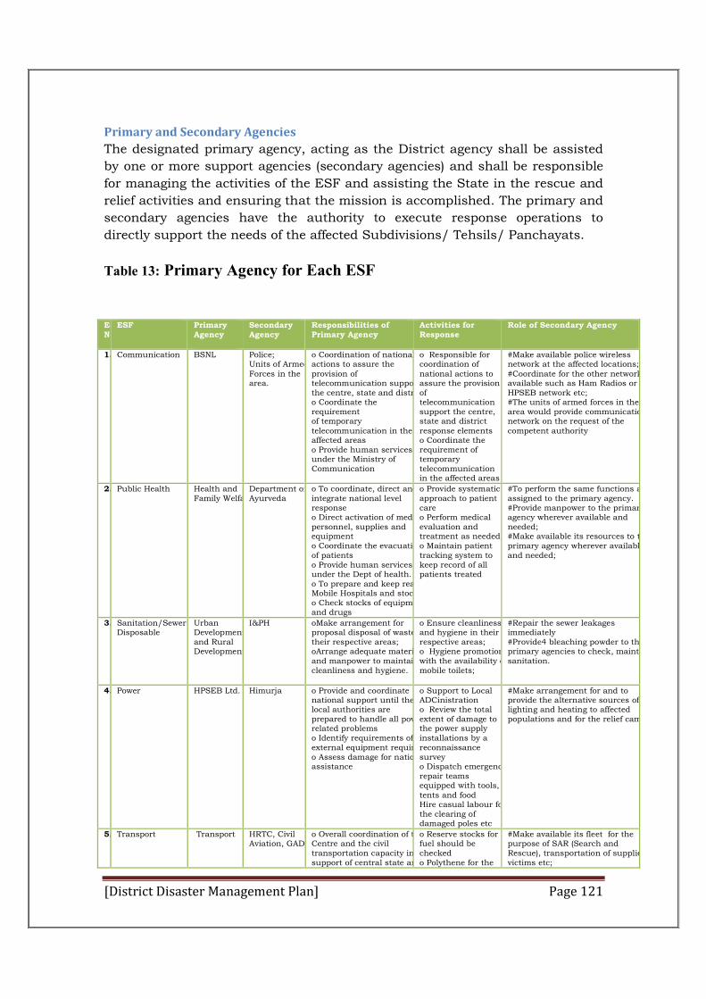
[District Disaster Management Plan] Page 121
Primary and Secondary Agencies
The designated primary agency, acting as the District agency shall be assisted
by one or more support agencies (secondary agencies) and shall be responsible
for managing the activities of the ESF and assisting the State in the rescue and
relief activities and ensuring that the mission is accomplished. The primary and
secondary agencies have the authority to execute response operations to
directly support the needs of the affected Subdivisions/ Tehsils/ Panchayats.
Table 13: Primary Agency for Each ESF
ESFNo
ESF Primary Agency
Secondary Agency
Responsibilities of Primary Agency
Activities for Response
Role of Secondary Agency
1. Communication BSNL Police; Units of Armed Forces in the area.
o Coordination of nationalactions to assure the provision of telecommunication supportthe centre, state and districto Coordinate the requirement of temporary telecommunication in the affected areas o Provide human services under the Ministry of Communication
o Responsible for coordination of national actions to assure the provision of telecommunication support the centre, state and district response elements o Coordinate the requirement of temporary telecommunication in the affected areas
#Make available police wireless network at the affected locations;#Coordinate for the other networks available such as Ham Radios or HPSEB network etc; #The units of armed forces in the area would provide communication network on the request of the competent authority
2. Public Health Health and Family Welfare
Department of Ayurveda
o To coordinate, direct andintegrate national level response o Direct activation of medicalpersonnel, supplies and equipment o Coordinate the evacuationof patients o Provide human services under the Dept of health. o To prepare and keep ready Mobile Hospitals and stocko Check stocks of equipmentand drugs
o Provide systematic approach to patient care o Perform medical evaluation and treatment as needed o Maintain patient tracking system to keep record of all patients treated
#To perform the same functions as assigned to the primary agency. #Provide manpower to the primary agency wherever available and needed; #Make available its resources to the primary agency wherever available and needed;
3. Sanitation/Sewerage Disposable
Urban Development and Rural Development.
I&PH oMake arrangement for proposal disposal of waste in their respective areas; oArrange adequate material and manpower to maintain cleanliness and hygiene.
o Ensure cleanliness and hygiene in their respective areas; o Hygiene promotion with the availability of mobile toilets;
#Repair the sewer leakages immediately #Provide4 bleaching powder to the primary agencies to check, maintain sanitation.
4. Power HPSEB Ltd. Himurja o Provide and coordinate national support until thelocal authorities are prepared to handle all powerrelated problems o Identify requirements ofexternal equipment requiredo Assess damage for nationalassistance
o Support to Local ADCinistration o Review the total extent of damage to the power supply installations by a reconnaissance survey o Dispatch emergencyrepair teams equipped with tools, tents and food Hire casual labour forthe clearing of damaged poles etc
#Make arrangement for and to provide the alternative sources of lighting and heating to affected populations and for the relief camps.
5. Transport Transport HRTC, Civil Aviation, GAD
o Overall coordination of theCentre and the civil transportation capacity insupport of central state and
o Reserve stocks for fuel should be checked o Polythene for the
#Make available its fleet for the purpose of SAR (Search and Rescue), transportation of supplies, victims etc;
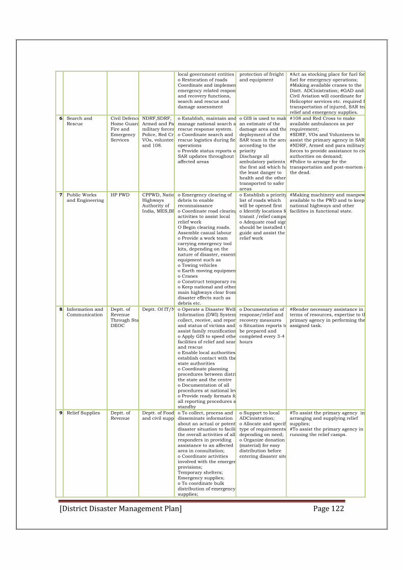
[District Disaster Management Plan] Page 122
local government entities o Restoration of roads Coordinate and implementemergency related responseand recovery functions, search and rescue and damage assessment
protection of freight and equipment
#Act as stocking place for fuel for fuel for emergency operations; #Making available cranes to the Distt. ADCinistration; #GAD and Civil Aviation will coordinate for Helicopter services etc. required for transportation of injured, SAR team, relief and emergency supplies.
6. Search and Rescue
Civil Defence, Home Guards, Fire and Emergency Services
NDRF,SDRF, Armed and Para military forces, Police, Red Cross, VOs, volunteers and 108.
o Establish, maintain and manage national search and rescue response system. o Coordinate search and rescue logistics during fieldoperations o Provide status reports ofSAR updates throughout theaffected areas
o GIS is used to makean estimate of the damage area and thedeployment of the SAR team in the areaaccording to the priority Discharge all ambulatory patients forthe first aid which hasthe least danger to health and the otherstransported to safer areas
#108 and Red Cross to make available ambulances as per requirement; #SDRF, VOs and Volunteers to assist the primary agency in SAR;#NDRF, Armed and para military forces to provide assistance to civil authorities on demand; #Police to arrange for the transportation and post-mortem of the dead.
7. Public Works and Engineering
HP PWD CPPWD, National Highways Authority of India, MES,BRO
o Emergency clearing of debris to enable reconnaissance o Coordinate road clearingactivities to assist local relief work O Begin clearing roads. Assemble casual labour o Provide a work team carrying emergency tool kits, depending on the nature of disaster, essentialequipment such as o Towing vehicles o Earth moving equipmentso Cranes o Construct temporary roadso Keep national and othermain highways clear fromdisaster effects such as debris etc.
o Establish a prioritylist of roads which will be opened first o Identify locations fortransit /relief campso Adequate road signsshould be installed toguide and assist the relief work
#Making machinery and manpower available to the PWD and to keep national highways and other facilities in functional state.
8. Information and Communication
Deptt. of Revenue Through State DEOC
Deptt. Of IT/NICo Operate a Disaster Welfare Information (DWI) System to collect, receive, and report and status of victims and assist family reunifications;o Apply GIS to speed otherfacilities of relief and searchand rescue o Enable local authorities toestablish contact with thestate authorities o Coordinate planning procedures between district,the state and the centre o Documentation of all procedures at national levelo Provide ready formats forall reporting procedures as astandby
o Documentation of response/relief and recovery measures o Situation reports tobe prepared and completed every 3-4 hours
#Render necessary assistance in terms of resources, expertise to the primary agency in performing the assigned task.
9. Relief Supplies Deptt. of Revenue
Deptt. of Food and civil supplies
o To collect, process and disseminate information about an actual or potential disaster situation to facilitate the overall activities of all responders in providing assistance to an affected area in consultation; o Coordinate activities involved with the emergency provisions; Temporary shelters; Emergency supplies; o To coordinate bulk distribution of emergency supplies;
o Support to local ADCinistration; o Allocate and specify type of requirements depending on need; o Organize donation (material) for easy distribution before entering disaster site.
#To assist the primary agency in arranging and supplying relief supplies; #To assist the primary agency in running the relief camps.
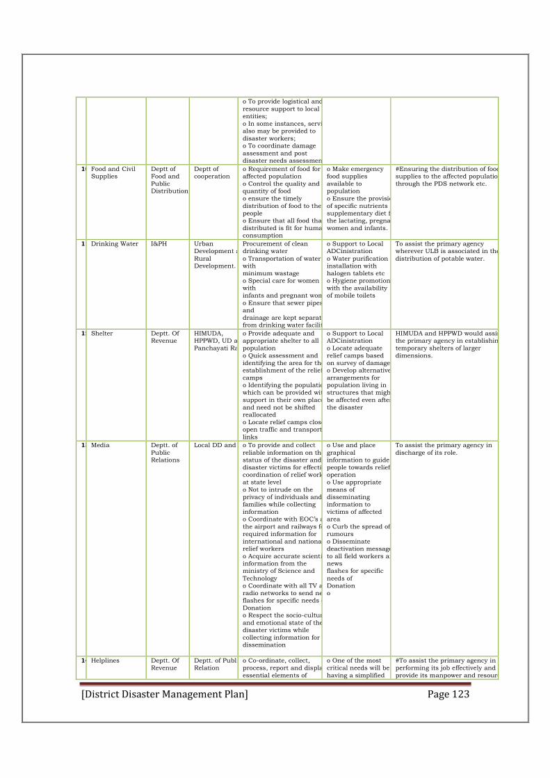
[District Disaster Management Plan] Page 123
o To provide logistical and resource support to local entities; o In some instances, services also may be provided to disaster workers; o To coordinate damage assessment and post disaster needs assessment.
10.Food and Civil Supplies
Deptt of Food and Public Distribution
Deptt of cooperation
o Requirement of food for affected population o Control the quality and quantity of food o ensure the timely distribution of food to the people o Ensure that all food that isdistributed is fit for humanconsumption
o Make emergency food supplies available to population o Ensure the provision of specific nutrients and supplementary diet for the lactating, pregnant women and infants.
#Ensuring the distribution of food supplies to the affected population through the PDS network etc.
11.Drinking Water I&PH Urban Development and Rural Development.
Procurement of clean drinking water o Transportation of water with minimum wastage o Special care for women with infants and pregnant womeno Ensure that sewer pipes and drainage are kept separate from drinking water facilitie
o Support to Local ADCinistration o Water purification installation with halogen tablets etc o Hygiene promotionwith the availability of mobile toilets
To assist the primary agency wherever ULB is associated in the distribution of potable water.
12.Shelter Deptt. Of Revenue
HIMUDA, HPPWD, UD and Panchayati Raj
o Provide adequate and appropriate shelter to all population o Quick assessment and identifying the area for theestablishment of the reliefcamps o Identifying the populationwhich can be provided withsupport in their own placeand need not be shifted reallocated o Locate relief camps close toopen traffic and transportlinks
o Support to Local ADCinistration o Locate adequate relief camps based on survey of damageo Develop alternativearrangements for population living in structures that mightbe affected even afterthe disaster
HIMUDA and HPPWD would assist the primary agency in establishing temporary shelters of larger dimensions.
13.Media Deptt. of Public Relations
Local DD and AIRo To provide and collect reliable information on thestatus of the disaster and disaster victims for effectivecoordination of relief workat state level o Not to intrude on the privacy of individuals andfamilies while collecting information o Coordinate with EOC’s atthe airport and railways forrequired information for international and nationalrelief workers o Acquire accurate scientificinformation from the ministry of Science and Technology o Coordinate with all TV andradio networks to send newsflashes for specific needs ofDonation o Respect the socio-culturaland emotional state of thedisaster victims while collecting information for dissemination
o Use and place graphical information to guide people towards reliefoperation o Use appropriate means of disseminating information to victims of affected area o Curb the spread ofrumours o Disseminate deactivation messageto all field workers and news flashes for specific needs of Donation o
To assist the primary agency in discharge of its role.
14.Helplines Deptt. Of Revenue
Deptt. of Public Relation
o Co-ordinate, collect, process, report and displayessential elements of
o One of the most critical needs will be having a simplified
#To assist the primary agency in performing its job effectively and provide its manpower and resources
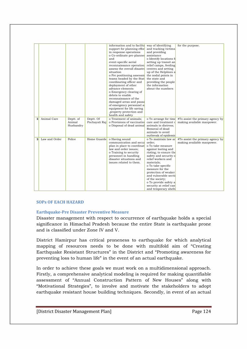
[District Disaster Management Plan] Page 124
information and to facilitatesupport for planning effortsin response operations o Co-ordinate pre-planned and event-specific aerial reconnaissance operations toassess the overall disastersituation o Pre positioning assessmentteams headed by the Statecoordinating officer and deployment of other advance elements o Emergency clearing of debris to enable reconnaissance of the damaged areas and passageof emergency personnel andequipment for life saving ,property protection and health and safety
way of identifying and tracking victims and providing assistance o Identify locations forsetting up transit andrelief camps, feeding centres and setting up of the Helplines atthe nodal points in the state and providing the people the information about the numbers
for the purpose.
15.Animal Care Deptt. of Animal Husbandry
Deptt. Of Pnchayati Raj
o Treatment of animals; o Provisions of vaccination;o Disposal of dead animals.
o To arrange for timely care and treatment of animals in distress; Removal of dead animals to avoid outbreak of epidemics.
#To assist the primary agency by making available manpower.
16.Law and Order Police Home Guards o Having sound communication and security plan in place to coordinate law and order issues; o Training to security personnel in handling disaster situations and issues related to them.
o To maintain law and order; o To take measure against looting and rioting; to ensure the safety and security of relief workers and materials; o To take specific measure for the protection of weaker and vulnerable sections of the society; o To provide safety and security at relief camps and temporary shelters.
#To assist the primary agency by making available manpower.
SOPs OF EACH HAZARD
Earthquake-Pre Disaster Preventive Measure
Disaster management with respect to occurrence of earthquake holds a special
significance in Himachal Pradesh because the entire State is earthquake prone
and is classified under Zone IV and V.
District Hamirpur has critical proneness to earthquake for which analytical
mapping of resources needs to be done with multifold aim of “Creating
Earthquake Resistant Structures” in the District and “Promoting awareness for
preventing loss to human life” in the event of an actual earthquake.
In order to achieve these goals we must work on a multidimensional approach.
Firstly, a comprehensive analytical modeling is required for making quantifiable
assessment of “Annual Construction Pattern of New Houses” along with
“Motivational Strategies”, to involve and motivate the stakeholders to adopt
earthquake resistant house building techniques. Secondly, in event of an actual
[District Disaster Management Plan] Page 125
earthquake scenario public is required to be guided and made aware about
“Safety Measures and Techniques”.
IIT Roorki has been indentify as Disaster Resource Institute for Northern States
and NIT Hamirpur has been identify as State Resource Institute for Hamirpur
for imparting training and conducting workshops for sensitizing the
stakeholders.
Blocks: The information regarding new construction in the rural areas can be collected through Gram Panchayats. In District Hamirpur there are 229 Grams Panchayat and therefore data regarding new constructions can be collected through sampled Panchayats. Out of 229 Gram Panchayats 40 Gram Panchayats have been randomly selected for getting information regarding new constructions.
Municipal Corporation and notified Area Committees. In municipal Committee and Notified Area Committees the construction is regulated by these Urban Local Bodies. Municipal Committee grants permission for construction of building in the meeting of Committee as per Himachal Pradesh Municipal Committee 1994 and Municipal Committee Hamirpur building Bylaws. The information regarding person intending to construct house can be collected through Executive Officer of MC/NAC.
Town & country Planning Department: Town and Country Planning Department gives sanction to housing plans. The person planning to construct houses apply to Town & Country Planning for approval of their plans, therefore, data regarding potential individuals intending to construct house can be collected from Town and Country Planning Department.
II. Identification of target groups:-
In order to associate and sensitized people to adopt Earthquake
Resistant Structural Design, we need to identify the Stakeholders involved. The
following is the list of “Target Group” which needs to be oriented toward
Earthquake Resistant Structural Design:-
House Owners. Contractors. Engineers. Architects. Masons.
We also need to outline the source from where information about above
mentioned target group can be obtained.
House Owners. The possible source from where information about people
intending to construct houses can be obtained is as follows:-
Banks : Applications received for house loans
NAC/MC: Application to whom permission for new construction is granted
[District Disaster Management Plan] Page 126
Gram Panchayats: Ward Members can be asked to inform G.P. Secretary as and when the
construction of new building starts. This information can be collected at Block Level through
Panchayat Secretaries.
Contractors:- At present we have 125 registered contractors with HPPWD in District Hamirpur.
Engineers: - Baseline survey needs to be done to find out exact number of Private Engineers working in the field of construction of buildings in the District Hamirpur.
Architects: -The information regarding registered Architects in the District van be collected from Town & Country Planning Department. At present there are 25 registered Architect in the District.
Masons:-Baseline survey is required to be done to obtained information regarding nos. of masons engaged in the building construction work in the District Hamirpur. Also, a mechanism can be worked out wherein this resource directory can be easily prepared by collecting information from BDO’s through Panchayats Secretaries.
III. Strategies Regarding “Pre Earthquake Preventing Measures”:-
It is not the earthquake rather it is the building that kills people. If the collapse
of single building can because possible to stop, it can save many lives residing
in that building. It is not possible to abandon to abandon all the old buildings,
under the potential threat of earthquake. However it is quite possible that all
the newly constructed buildings and structures must be brought under strict
building code that resists earthquake damage. For pre Earthquake Preventive
Measures following strategy can be adopted:
Orientation of the Target Group: To train and educate people regarding
“Earthquake Resistant Structures” the identified target group would be trained
and sensitized through a series of workshops and seminars to be organized
through NIT and State Council of Science and Technology for adopting
“Earthquake Resistant Techniques”. They shall also be exposing to low cost.
“Earthquake Resistant Housing Technologies” so that the new housing has
“Earthquake Resistant’ features. If 300 persons n(Target Group) are to be
sensitized, then 25 to 30 one day training/ orientation camps are required for a
batch of 100 persons.
Cost of Training:At a rate Rs. 100 per person per day, cost of conducting
training/orientation camps shall be approximately Rs3 lacs.
Involvement of NIT/SRI for conducting training and workshops:
Training and workshops regarding Earthquake Resistant Structures can be
organized with the help of NIT Hamirpur. NIT shall be the nodal agency for
conducting training workshop for identified target groups.
Cost effective designs of Earthquake Resistant Structures can be
prepared with the help of NIT. Wherein a guide book of cost calculation for
houses having “Earthquake Resistant” features can be designed for different
categories of construction. To educate people about “inexpensive” structural
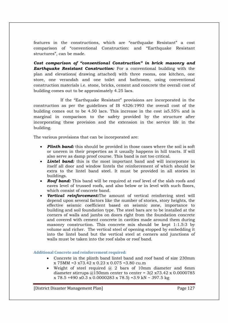
[District Disaster Management Plan] Page 127
features in the constructions, which are “earthquake Resistant” a cost
comparison of “conventional Construction: and “Earthquake Resistant
structures”, can be made.
Cost comparison of “conventional Construction” in brick masonry and
Earthquake Resistant Construction: For a conventional building with the
plan and elevations( drawing attached) with three rooms, one kitchen, one
store, one verandah and one toilet and bathroom, using conventional
construction materials i.e. stone, bricks, cement and concrete the overall cost of
building comes out to be approximately 4.25 lacs.
If the “Earthquake Resistant” provisions are incorporated in the
construction as per the guidelines of IS 4326:1993 the overall cost of the
building comes out to be 4.50 lacs. This increase in the cost is5.55% and is
marginal in comparison to the safety provided by the structure after
incorporating these provision and the extension in the service life in the
building.
The various provisions that can be incorporated are:
Plinth band: this should be provided in those cases where the soil is soft or uneven in their properties as it usually happens in hill tracts. If will also serve as damp proof course. This band is not too critical.
Lintel band: this is the most important band and will incorporate in itself all door and window lintels the reinforcement of which should be extra to the lintel band steel. It must be provided in all stories in buildings.
Roof band: This band will be required at roof level of the slab roofs and eaves level of trussed roofs, and also below or in level with such floors, which consist of concrete band.
Vertical reinforcement:The amount of vertical reinforcing steel will depend upon several factors like the number of stories, story heights, the effective seismic coefficient based on seismic zone, importance to building and soil foundation type. The steel bars are to be installed at the corners of walls and jambs on doors right from the foundation concrete and covered with cement concrete in cavities made around them during masonry construction. This concrete mix should be kept 1:1.5:3 by volume and richer. The vertical steel of opening stopped by embedding it into the lintel band but the vertical steel at corners and junctions of walls must be taken into the roof slabs or roof band.
Additional Concrete and reinforcement required:
Concrete in the plinth band lintel band and roof band of size 230mm x 75MM =3 x73.42 x 0.23 x 0.075 =3.80 cu.m
Weight of steel required @ 2 bars of 10mm diameter and 6mm diameter stirrups @150mm center to center = 3(2 x73.42 x 0.0000785 x 78.5 +490 x0.3 x 0.0000283 x 78.5) =3.9 kN ~ 397.5 kg
[District Disaster Management Plan] Page 128
Weight of steel required around the openings and near corners and T-junctions in the walls = 30 x 2.90x 0.000078 x 78.5 =0,53 kN ~ 54 kg
Total steel = 451.5 kg Cost of concrete = 3.80 x 2102.28 = Rs. 7988.66 Cost of steel = 451.5 x 37.47 = Rs. 16917.70 Total increase in cost = 24906.36 ~ Rs. 25000
Result : (%age increase in the cost = 5.55%)
Thecost comparison of “Conventional Construction” in brick
masonry and “Earthquake Resistant” constructions shows that there is an
increase of 5.55% in the cost of construction with “Earthquake Resistant”
features. This increase is marginal as compared to the safety provided by the
structure in the event of an Earthquake.
Legislative Inclusions to make Earthquake Resistant feature a mandatory
part of house/building constructions in Urban as well as in rural areas is
required. Moreover reframing of building code guidelines, manuals and bylaws
and their strict implementation is needed.
Instructions are required to be given to all Financial Instructions to make
advance to that person only who submit “Earthquake Resistant Design” of the
building.
MCs/NACs are also required to be directed to give approval in case of
those constructions, where proposals are certified by “Structural Engineer”
having Earthquake Resistant Features.
For regulating construction in Rural Area Panchayati Raj Act is
required to be amended. A Provision of approval of Gram Panchayat regarding
new constructions is required to be incorporated.
IV. Awareness about “Safety Measures and Techniques”:-
In order to create awareness among public regarding “ Earthquake Safety Measures and Techniques”, an information booklet containing do’s and don’t in Hindi and English can prepared, which may be circulated to:
All Educational Institutional i.e. Middle/Secondary Schools, Private Schools and Colleges.
All Gram Panchayats & Public Institutions.
Suggestions:
Identification of all “LifeLineBuilding” in the District is required I to be done.
These building may be got “Seismological Assessed” and if necessary
“Retrofitting Measures” may be adopted.
[District Disaster Management Plan] Page 129
Efforts are required to “Evolve Educational Curricula” in architecture and Engineering Institutions and Technical training in polytechnics and Schools to include disaster, related topics.
Private Engineers and Masons should be registered and their activities be regulated though appropriate rules and regulations.
Instructions are required to be given to all Financial Institutions to make advances to those persons only who submit an “Earthquake Resistant Design” of the building that is intended to be constructed.
Ward Panch can be asked to inform the Gram Panchayat Secretary as and when construction of new building starts so that concerned mason and the owner may be provided information regarding “Earthquake Resistant Techniques” for the construction of the buildings.
EARTHQUAKE –PREDISASTER PREVENTIVE MEASURES:
Disaster management with respect to occurrence of earthquake holds a
special significance in Himachal Pradesh because the entire State is earthquake
prone and is classified under Zone IV.
District Hamirpur has critical proneness to earthquake for which
“Earthquake Preventive Measures” are required to be taken. These measures
include “Constructing Earthquake Resistant Structure” and “Creating
Awareness” About “Safety Measure and Techniques”.
In order to achieve these goals we must work on a multidimensional
approach. Firstly, a comprehensive analytical modeling is required for making
quantifiable assessment of “Annual Construction Pattern of New Houses” along
with “Motivational Strategies”, to involve and motivate the stakeholders to adopt
“Earthquake Resistant” “House building Techniques”. In event of an actual
earthquake scenario, public is required to be guided and made aware about
“Safety Measures and Techniques”.
The assessment of “ Annual Construction Pattern” in District Hamirpur
can be done by collecting data through Banks (on the basis of loan application
sanctioned), Blocks(regarding construction in Rural Area), MC/NAC & T&CP
(regarding construction in Urban Area)/ Trends in the sanctioning of house
loans by the banks during 2003-04,2004-05,2005-06 show an annual average
increase of 7.15%,. This annual average increase is a growth factor for the
construction on the basis of which projections for new construction can be
made. During 2005-06 2415 Nos. new houses were constructed in the District
and for 2006-07 2539 Nos. of houses are projected to be constructed.
In order to associate and sensitized people regarding “Earthquake
Resistant Structures, we have identified “Target Groups”, these are House
Owner, Contractors, Engineers, Architects and Masons.
For Pre Earthquake Preventive Measure different strategies are required
to be adopted. Firstly identified “Target Groups” would be trained and sensitized

[District Disaster Management Plan] Page 130
regarding “Earthquake Resistant Structure” through workshops and seminars.
Secondly Specialized institute i.e. NIT/SRI can be involved for conducting
training and workshops “Target Group” shall be exposed to low cost
“Earthquake Resistant Housing Technologies”. “Cost Effective Designs” of
“Earthquake Resistant Structures” can be prepared with the help of NIT where
in a guide book of cost calculation for houses having “Earthquake Resistant’
feature can be designed for different categories of constructions. Cost
compression of conventional constructions in the brick masonry and
“Earthquake Resistant Structure” shows that there is an increase of 5.5% in the
cost of construction with “Earthquake Resistant” features. This increase is
marginal as compared to safety provided by the structures in the event of actual
Earthquake. Legislative measure to make “Earthquake Resistant” features as a
mandatory part of house/ building construction in Urban as well as in Rural
area are require to be taken. Instructions are required to be given to all
Financial Instructions to make advances to those persons only who submit
“Earthquake Resistant Design” of the building MCs/NACs are also required to
be directed to give approval incase of those constructions, where proposals are
certified by “Structural Engineer” having Earthquake Resistant features.
Awareness about safety measures is required to be created among public. For
this booklet containing do’s and don’ts can be prepared, which can be
circulated to all Educational and other Public Institutional”. It is suggested that
private Engineers and Masons should be registered and their activities be
regulated though appropriate rules and regulations.
Drought:
This problem is being faced in Bamson, Bhoranj, Hamirpur, Bijhari and some
parts of Nadaun and Sujanpur blocks. The district ADCinistration is combating
this problem by deploying drinking water tankers, installation of deep water
hand-pumps and reviving the traditional water sources.
In order to check this problem district has 4 Nos. of Watershed/ Hariyali
Projects, which are at various stages of implementation. The total outlay of
these projects is 20.49 Crores. A watershed project Rs. 5.00 crores in respect of
development block Hamirpur and Sujanpur has been completed. In these
projects stress has been laid on soil moister conservation by constructing small
nalla bandhs and big check dams. In total 612 Nos. of check dams/ Nalla
bandh have been constructed. Out of these 86 Nos. check dams are relatively of
big size. Out of 612 check dams/ nalla bandhs 526 Nos. have water stored in
them. The construction of these check dams has lead to the charging of the
ground water and as a result some of the dry traditional water sources have
been revived. Hand pumps were installed in the areas/ villages of water scarcity
where there was a possibility of installation of hand pumps(Table ). The detail of
the hand pumps installed is as follows:
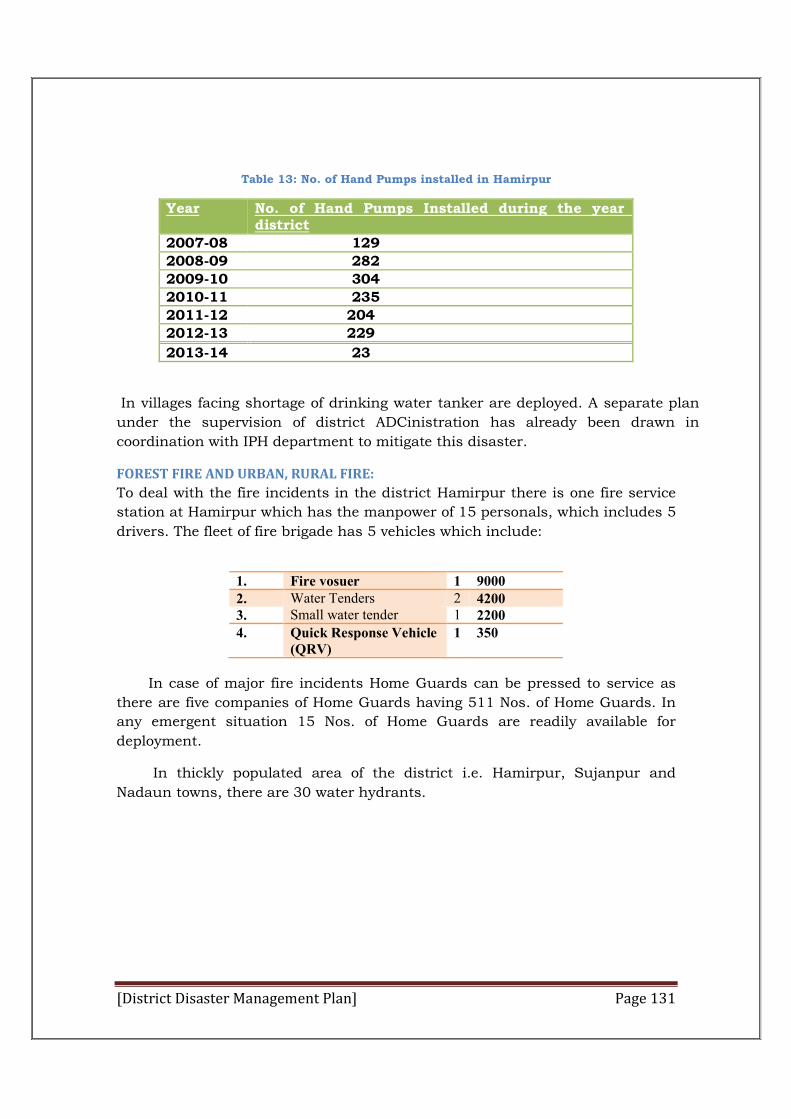
[District Disaster Management Plan] Page 131
Table 13: No. of Hand Pumps installed in Hamirpur
Year No. of Hand Pumps Installed during the year in district
2007-08 129
2008-09 282
2009-10 304
2010-11 235
2011-12 204
2012-13 229
2013-14 23
In villages facing shortage of drinking water tanker are deployed. A separate plan
under the supervision of district ADCinistration has already been drawn in
coordination with IPH department to mitigate this disaster.
FOREST FIRE AND URBAN, RURAL FIRE:
To deal with the fire incidents in the district Hamirpur there is one fire service
station at Hamirpur which has the manpower of 15 personals, which includes 5
drivers. The fleet of fire brigade has 5 vehicles which include:
1. Fire vosuer 1 9000 2. Water Tenders 2 4200 3. Small water tender 1 2200 4. Quick Response Vehicle
(QRV) 1 350
In case of major fire incidents Home Guards can be pressed to service as
there are five companies of Home Guards having 511 Nos. of Home Guards. In
any emergent situation 15 Nos. of Home Guards are readily available for
deployment.
In thickly populated area of the district i.e. Hamirpur, Sujanpur and
Nadaun towns, there are 30 water hydrants.
[District Disaster Management Plan] Page 132
Chapter-VIII
RELIEF, RECOVERY, REHABILITATION AND RECONSTRUCTION PLAN
Relief, rehabilitation, reconstruction and recovery are important phases of post
disaster response. Relief is no longer perceived only as gratuitous assistance or
provision of emergency relief supplies on time. It is on the contrary, viewed as an
overarching system of facilitation of assistance to the victims of disaster for their
rehabilitation in States and ensuring social safety and security of the affected
persons. The relief needs to be prompt, adequate and of approved standards.
The recovery phase starts after the immediate threat to human life has subsided.
During reconstruction it is recommended to consider the location or construction
material of the property. The approach to the reconstruction process has to be
comprehensive so as to convert adversity into opportunity. Incorporating disaster
resilient features to ‘build back better’ will be the guiding principle. This phase
requires the most patient and pain staking effort by all concerned. The
ADCinistration, the stakeholders and the communities need to stay focused on the
needs of this phase, as, with the passage of time, the sense of urgency gets diluted.
The appropriate choice of technology and project impact assessment needs to be
carried out to establish that the projects contemplated do not create any side
effects on the physical, socio- cultural or economic environment of the
communities in the affected areas or in their neighbourhood. The involvement of
community in decision making is important. Systems for providing psycho social
support and trauma counselling would be developed for implementation during the
reconstruction and recovery phase.
OWNER DRIVEN CONSTRUCTION
Reconstruction plans and designing of houses need to be participatory process
involving the affected community, NGO, corporate sector and the Government.
Having a clear cut policy on entitlement, criteria for GIA and land ownership,
relocation, exchange of land will facilitate speedy reconstruction. After the planning
process is over, while the owner driven construction is preferred option,
participation of NGO, corporate sector and technical experts will be encouraged to
ensure safe and better reconstruction. Reconstruction programme will be within
the confines and the qualitative specifications laid down by the Government. In
order to have acceptability for the safe and quality standards construction norms,
designs and guidelines will be finalised during normalcy so that community is well
aware of them. Services of CBO, CSOs, and faith based organisation will be taken
for this purpose to gain acceptance.
[District Disaster Management Plan] Page 133
RECONSTRUCTION OF SOCIAL INFRA STRUCTURE
Essential services, social infrastructure and intermediate shelters/camps will be
established in the shortest possible time. For permanent reconstruction, ideally,
the work including the construction of houses must be completed within two to
three years. State Government and Departments of State Government should
create dedicated project teams to speed up there construction process. Involvement
of PRIs and ULBs for reconstruction at local level will be encouraged.
SOCIO-ECONOMIC REHABILITATION
Disasters destroy development and livelihood sources. In the post disaster
situation there is great need to generate temporary livelihood options for the
affected community. The relief and reconstruction programmes would be used to
generate livelihood options for the needy. On-going or new programmes may be
launched which may help the affected community to earn their livelihood. It would
be ensured that such programmes result in the creation of assets, infrastructure,
and amenities that such assets are hazard resistant, durable, and sustainable.
Disasters may also end up in destroying the existing village or housing site sand
re-settlement in the existing locations may no longer be possible. Possible sites for
re-location of habitation would be identified.
LINKING RECOVERY WITH SAFE DEVELOPMENT/ RECONSTRUCTION – “BUILDING BACK
BETTER”
It will be ensured that the post disaster development/ reconstruction do not end
up in rebuilding the existing vulnerability. The reconstruction phase would be
utilised to incorporate the building codes, safe construction practices, and zoning
regulations. Contingency plans for reconstruction in highly disaster prone areas
would be drawn out during the period of normalcy, which would include
architectural and structural designs in consultation with the various stakeholders.
Emphasis will be laid on plugging the gaps in the social and economic
infrastructure and infirmities in the backward and forward linkages. Efforts will be
made to support and enhance the viability of livelihood systems, education, health
care facilities, care of the elderly, women and children, etc. Other aspects
warranting attention will be roads, housing, drinking water sources, provision for
sanitary facilities, availability of credit, supply of agricultural inputs, up-gradation
of technologies in the on-farm and off-farm activities, storage, processing,
marketing, etc.
RELIEF
The victims of disaster would need to be provided relief as per the relief code of the
State. Displaced population may require to be housed in temporary shelters. The
DDMAs would identify locations for setting up temporary camps and make an
inventory in advance of them. Use of premises of educational institutions for
[District Disaster Management Plan] Page 134
setting up relief camps need to be discouraged as it hampers DDMP early recovery.
Relief camps will have adequate provision of drinking water, and bathing,
sanitation and essential health care facilities. The PRIs, ULBs, CSOs and CBOs
shall be trained in handling and running relief camps. The disaster affected
population can also be roped in to manage community kitchens. Guidelines/SOPs
for efficient governance of relief camps such as identification cards, rationing,
entitlement, management of donations, procurement, packaging, transportation
and storage etc. may be issued in advance. The stock- piling of essential relief
material at suitable locations is also important. Pre-contracting of relief supplied
with agencies is important during pre-disaster phase. In case of devastating
disaster extreme weather conditions can be life threatening or when the period of
stay in temporary shelters is likely to be long and uncertain, construction of site
specific be fitting the local environment, ecology and culture, immediate shelters
with suitable sanitary facility will be undertaken to ensure are as on able quality of
life to the affected people. The DDMAs in consultation with the SDMA will plan
such shelters which are cost effective and as per the local needs with multi-use
potential. Pre-identification of their availability, supply and testing in the local
conditions will be done. The relief supplies would pay attention to the needs of
special categories such as pregnant or lactating mothers, infants, new-borns,
adolescents, and aged people.
[District Disaster Management Plan] Page 135
Chapter-IX
Financial Provision and Implementation of DDMP
With the paradigm shift in DM from the relief-centric to proactive approach of
prevention, mitigation, capacity building, preparedness, response, evacuation,
rescue, relief, rehabilitation and reconstruction, effort would be made to
mainstream and integrate disaster risk reduction and emergency response in
development process, plans and programmes of the Government at all levels. This
would be done by involving all the stakeholders–Government organisations,
research and academic institutions, private sector, industries, civil society
organisation and community. DDMA will ensure mainstreaming of disaster risk
reduction in the developmental agenda of all existing and new developmental
programmes and projects which shall incorporate disaster resilient specifications
in design and construction. Due weightage will be given to these factors while
allocating resources. Project which help in reducing the existing vulnerability of the
area would be given preference over projects which are likely to enhance it.
DISASTER RESPONSE AND MITIGATION FUNDS
District Disaster Response Fund and District Disaster Mitigation fund would be
created at the District Level as mandated in the Act (Section 48).The disaster
response funds at the district level would be applied by the DDMA towards meeting
expenses for emergency response, relief, rehabilitation in accordance with the
guidelines and norms laid down by the Government of India and the State
Government. The mitigation funds shall be applied by the DDMAs for the purpose
of mitigation as per the HPDM Rules, 2011.
RESPONSIBILITIES OF THE STATE DEPARTMENTS AND AGENCIES
All State Government Departments, Boards, Corporations, PRIs and ULBS will
prepare their DM plans including the financial projections to support these plans.
The necessary financial allocations will be made as part of their annual budgetary
allocations, and ongoing programmes. They will also identify mitigation projects
and project them for funding in consultation with the SDMA/DDMA to the
appropriate funding agency. The guidelines issued by the NDMA Visa Vis various
disasters may be consulted while preparing mitigation projects.
TECHNO-FINANCIAL REGIME
Considering that the assistance provided by the Government for rescue, relief,
rehabilitation and reconstruction needs cannot compensate for massive losses on
account of disasters, new financial tools such as catastrophe risk financing, risk
insurance, catastrophe bonds, micro-finance and insurance etc., will be promoted
[District Disaster Management Plan] Page 136
with innovative fiscal incentives to cover such losses of individuals, communities
and the corporate sector. In this regard, the Environmental Relief Fund under the
Public Liability Insurance Act, 1991, enacted for providing relief to chemical
accident victims is worth mentioning. Some financial practices such as disaster
risk insurance, micro-finance and micro-insurance, warranty on newly constructed
houses and structures and linking safe construction with home loans will be
considered for adoption.
[District Disaster Management Plan] Page 137
Chapter-X
Monitoring, Evaluation, Updation and Maintance of DDMP
The following monitoring and evaluation procedure would be followed to make the
plan functional and a living document:-
The DDMA shall regularly review the implementation of the plan.
In order to improve the plan the DDMA would check the efficacy of the plan
after any major disaster/emergency in the district and see what did work
and what did not work and make amendments to the plan accordingly.
As per Sub Section (4) of Section 31 of the Disaster Management Act, 2005
the plan would be reviewed and updated annually and the year in which the
plan has been reviewed would be clearly mentioned in shape of header in
each page of the plan.
Resource inventory of the district fed into the IDRN would be regularly
updated and appended to the plan.
Names and contact details of the officers/officials who are the nodal officers
or the in charge of resources to be updated on regular basis.
A soft copy of the plan would always be kept in the DDMA website for
reference by all concerned.
A Copy of the plan would be sent to all the stakeholder departments,
agencies and organisations so that they know their role and responsibilities
and they are also prepare their own plans.
Regular Mock Drills should be conducted to test the efficacy of the plan and
check the level of preparedness of various departments and other
stakeholders.
Regular training and orientation of the officers/officials responsible to
implement the plan should be done so that it becomes and useful document
to the district ADCinistration.
Regular interaction and meetings with the CPMFs and Army or any other
central government agency would be done by the DDMA should that there is
no problem of coordination during disasters. The representatives of these
organisations should be invited as expert for the DDMA meeting. A copy of
the DDMP should also be shared with them.
The DEOC would assist the DDMA in keeping the plan in updated form and
collecting, collating and processing the information.
The DDMP would be comprehensively reviewed in the year 2013 latest by
March and incorporating feedback from the departments and field officers.
[District Disaster Management Plan] Page 138
PART II
ANNEXURE
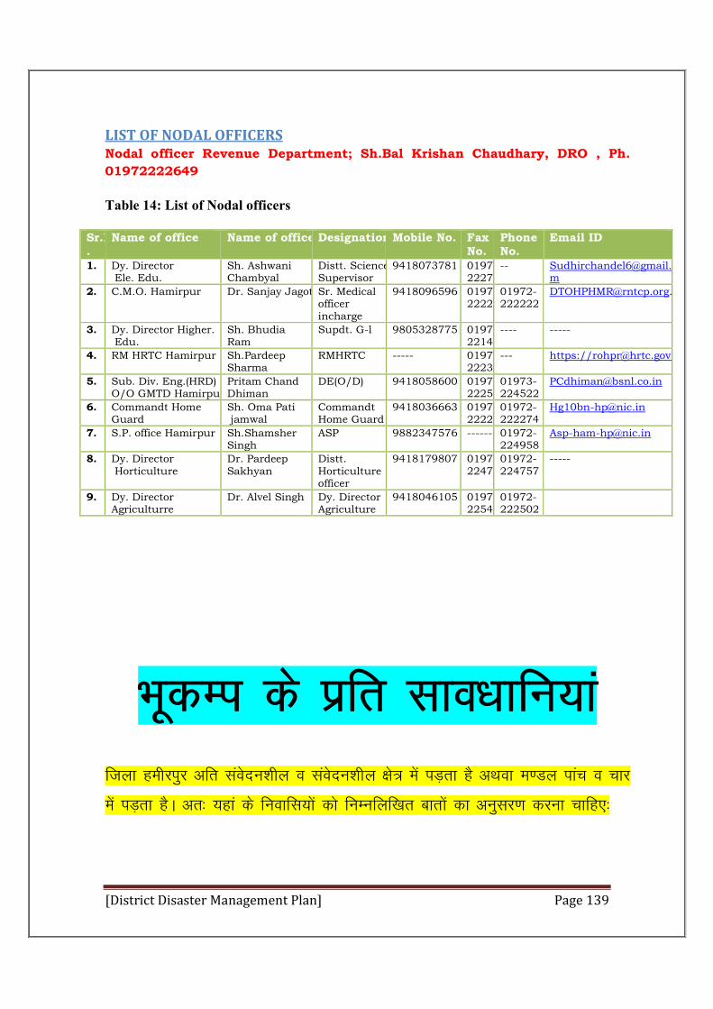
[District Disaster Management Plan] Page 139
LIST OF NODAL OFFICERS Nodal officer Revenue Department; Sh.Bal Krishan Chaudhary, DRO , Ph.
01972222649
Table 14: List of Nodal officers
Sr.No.
Name of office Name of officerDesignation Mobile No. Fax No.
Phone No.
Email ID
1. Dy. Director Ele. Edu.
Sh. Ashwani Chambyal
Distt. Science Supervisor
9418073781 01972222749
2. C.M.O. Hamirpur Dr. Sanjay JagotaSr. Medical officer incharge
9418096596 01972222203
01972-222222
3. Dy. Director Higher. Edu.
Sh. Bhudia Ram
Supdt. G-l 9805328775 01972221499
---- -----
4. RM HRTC Hamirpur Sh.Pardeep Sharma
RMHRTC ----- 01972222326
--- https://[email protected]
5. Sub. Div. Eng.(HRD) O/O GMTD Hamirpur
Pritam Chand Dhiman
DE(O/D) 9418058600 01972222580
01973-224522
6. Commandt Home Guard
Sh. Oma Pati jamwal
Commandt Home Guard
9418036663 01972222274
01972-222274
7. S.P. office Hamirpur Sh.Shamsher Singh
ASP 9882347576 --------01972-224958
8. Dy. Director Horticulture
Dr. Pardeep Sakhyan
Distt. Horticulture officer
9418179807 01972224757
01972-224757
-----
9. Dy. Director Agriculturre
Dr. Alvel Singh Dy. Director Agriculture
9418046105 01972225482
01972-222502
HkwdEi ds izfr lko/kkfu;ka ftyk gehjiqj vfr laosnu”khy o laosnu”khy {ks= esa iM+rk gS vFkok e.My ikap o pkj
esa iM+rk gSA vr% ;gka ds fuokfl;ksa dks fuEufyf[kr ckrksa dk vuqlj.k djuk pkfg,%
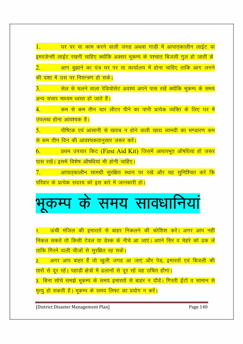
[District Disaster Management Plan] Page 140
1. ?kj ij ;k dke djus okyh txg vFkok xkM+h eas vkikr~dkyhu ykbZV ;k
bejtsUlh ykbZV j[kuh pkfg, D;ksafd vDlj HkwdEi ds Ik”pkr fctyh xqy gks tkrh Gsa
2. vkx cq>kus dk ;a= ?kj ij ;k dk;kZy; esa gksuk pkfg, rkfd vkx yxus
dh n”kk eas ml ij fu;U=.k gks ldsA
3. lsy ls pyus okyk jsfM;kslsV vo”; vius ikl j[ksa D;ksafd HkwdEi ds le;
vU; lapkj ek/;e /oLr gks tkrs gSaA
4. de ls de rhu pkj yhVj ihus dk ikuh izR;sd O;fDr ds fy, ?kj esa
miyO/k gksuk vko”;d gSA
5. ikSf’Vd ,oa vklkuh ls [kjkc u gksus okyh [kk| lkexzh dk Hk.Mkj.k de
ls de rhu fnu dh vko”;drkuqlkj t:j djsaA
6. izFke mipkj fdV (First Aid Kit) ftlesa vk/kkjHkwr vkS’kf/k;ka gksa t:j
ikl j[ksaA blesa fo”ks’k vkS’kf/k;ka Hkh gksuh pkfg,A
7. vkikr~dkyhu lkexzh lqjf{kr LFkku ij j[ksa vkSj ;g lqfuf”pr djsa fd
ifjokj ds izR;sd lnL; dks bl ckjs esa tkudkjh gksA
HkwdEi ds le; lko/kkfu;ka 1- Åaph eafty dh bekjrksa ls ckgj fudyus dh dksf”k”k djsaA vxj vki ugha
fudy ldrs rks fdlh Vsoy ;k MsLd ds uhps vk tk,aA vius flj o psgjs dks <d ysa
rkfd fxjus okyh phtksa ls lqjf{kr jg ldsaA
2- vxj vki ckgj gSa rks [kqyh txg vk tk,a vkSj isM]+ bekjrksa ,oa fctyh dh
rkjksa ls nwj jgsaA igkM+h {ks+=ksa esa <ykuksa ls nwj jgsa ;g mfPkr gkssxkA
3- fcuk lksps le>s HkwdEi ds le; bekjrksa ls ckgj Uk nkSMsaA fxjrh bZaVksa o lkeku ls
e`R;q gks ldrh gSA HkwdEi ds le; fy¶V dk iz;ksx u djsaA
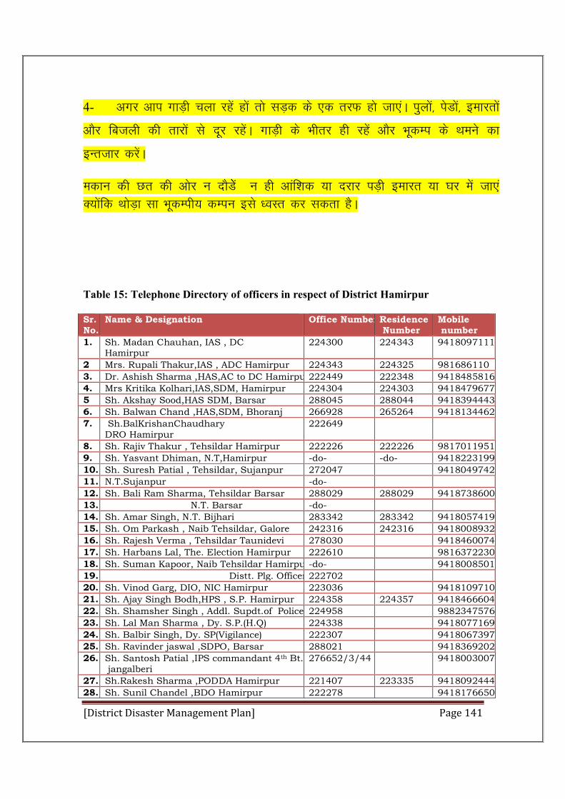
[District Disaster Management Plan] Page 141
4- vxj vki xkM+h pyk jgsa gksa rks lM+d ds ,d rjQ gks tk,aA iqyksa] isMksa] bekjrksa
vkSj fctyh dh rkjksa ls nwj jgsaA xkM+h ds Hkhrj gh jgsa vkSj HkwdEi ds Fkeus dk
bUrtkj djsaA
edku dh Nr dh vksj u nkSMssa u gh vkaf”kd ;k njkj iM+h bekjr ;k ?kj esa tk,a D;kasfd FkksM+k lk HkwdEih; dEiu bls /oLr dj ldrk gSA
Table 15: Telephone Directory of officers in respect of District Hamirpur
Sr. No.
Name & Designation Office Number Residence Number
Mobile number
1. Sh. Madan Chauhan, IAS , DC Hamirpur
224300 224343 9418097111
2 Mrs. Rupali Thakur,IAS , ADC Hamirpur 224343 224325 981686110
3. Dr. Ashish Sharma ,HAS,AC to DC Hamirpur222449 222348 9418485816
4. Mrs Kritika Kolhari,IAS,SDM, Hamirpur 224304 224303 9418479677
5 Sh. Akshay Sood,HAS SDM, Barsar 288045 288044 9418394443
6. Sh. Balwan Chand ,HAS,SDM, Bhoranj 266928 265264 9418134462
7. Sh.BalKrishanChaudhary DRO Hamirpur
222649
8. Sh. Rajiv Thakur , Tehsildar Hamirpur 222226 222226 9817011951
9. Sh. Yasvant Dhiman, N.T,Hamirpur -do- -do- 9418223199
10. Sh. Suresh Patial , Tehsildar, Sujanpur 272047 9418049742
11. N.T.Sujanpur -do-
12. Sh. Bali Ram Sharma, Tehsildar Barsar 288029 288029 9418738600
13. N.T. Barsar -do-
14. Sh. Amar Singh, N.T. Bijhari 283342 283342 9418057419
15. Sh. Om Parkash , Naib Tehsildar, Galore 242316 242316 9418008932
16. Sh. Rajesh Verma , Tehsildar Taunidevi 278030 9418460074
17. Sh. Harbans Lal, The. Election Hamirpur 222610 9816372230
18. Sh. Suman Kapoor, Naib Tehsildar Hamirpur-do- 9418008501
19. Distt. Plg. Officer 222702
20. Sh. Vinod Garg, DIO, NIC Hamirpur 223036 9418109710
21. Sh. Ajay Singh Bodh,HPS , S.P. Hamirpur 224358 224357 9418466604
22. Sh. Shamsher Singh , Addl. Supdt.of Police 224958 9882347576
23. Sh. Lal Man Sharma , Dy. S.P.(H.Q) 224338 9418077169
24. Sh. Balbir Singh, Dy. SP(Vigilance) 222307 9418067397
25. Sh. Ravinder jaswal ,SDPO, Barsar 288021 9418369202
26. Sh. Santosh Patial ,IPS commandant 4th Bt. jangalberi
276652/3/44 9418003007
27. Sh.Rakesh Sharma ,PODDA Hamirpur 221407 223335 9418092444
28. Sh. Sunil Chandel ,BDO Hamirpur 222278 9418176650
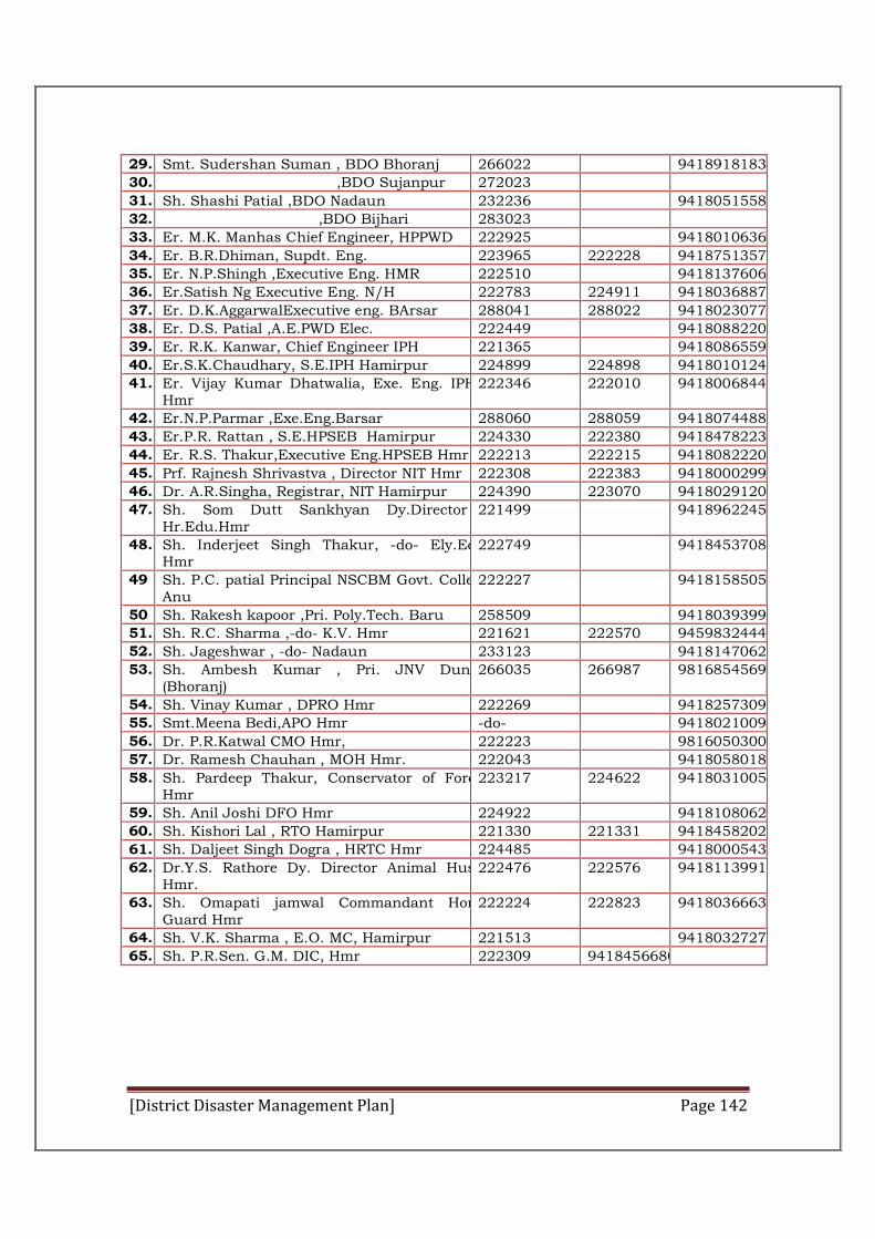
[District Disaster Management Plan] Page 142
29. Smt. Sudershan Suman , BDO Bhoranj 266022 9418918183
30. ,BDO Sujanpur 272023
31. Sh. Shashi Patial ,BDO Nadaun 232236 9418051558
32. ,BDO Bijhari 283023
33. Er. M.K. Manhas Chief Engineer, HPPWD 222925 9418010636
34. Er. B.R.Dhiman, Supdt. Eng. 223965 222228 9418751357
35. Er. N.P.Shingh ,Executive Eng. HMR 222510 9418137606
36. Er.Satish Ng Executive Eng. N/H 222783 224911 9418036887
37. Er. D.K.AggarwalExecutive eng. BArsar 288041 288022 9418023077
38. Er. D.S. Patial ,A.E.PWD Elec. 222449 9418088220
39. Er. R.K. Kanwar, Chief Engineer IPH 221365 9418086559
40. Er.S.K.Chaudhary, S.E.IPH Hamirpur 224899 224898 9418010124
41. Er. Vijay Kumar Dhatwalia, Exe. Eng. IPH , Hmr
222346 222010 9418006844
42. Er.N.P.Parmar ,Exe.Eng.Barsar 288060 288059 9418074488
43. Er.P.R. Rattan , S.E.HPSEB Hamirpur 224330 222380 9418478223
44. Er. R.S. Thakur,Executive Eng.HPSEB Hmr 222213 222215 9418082220
45. Prf. Rajnesh Shrivastva , Director NIT Hmr 222308 222383 9418000299
46. Dr. A.R.Singha, Registrar, NIT Hamirpur 224390 223070 9418029120
47. Sh. Som Dutt Sankhyan Dy.Director . Hr.Edu.Hmr
221499 9418962245
48. Sh. Inderjeet Singh Thakur, -do- Ely.Edc. Hmr
222749 9418453708
49 Sh. P.C. patial Principal NSCBM Govt. ColleAnu
222227 9418158505
50 Sh. Rakesh kapoor ,Pri. Poly.Tech. Baru 258509 9418039399
51. Sh. R.C. Sharma ,-do- K.V. Hmr 221621 222570 9459832444
52. Sh. Jageshwar , -do- Nadaun 233123 9418147062
53. Sh. Ambesh Kumar , Pri. JNV Dungri (Bhoranj)
266035 266987 9816854569
54. Sh. Vinay Kumar , DPRO Hmr 222269 9418257309
55. Smt.Meena Bedi,APO Hmr -do- 9418021009
56. Dr. P.R.Katwal CMO Hmr, 222223 9816050300
57. Dr. Ramesh Chauhan , MOH Hmr. 222043 9418058018
58. Sh. Pardeep Thakur, Conservator of Forest Hmr
223217 224622 9418031005
59. Sh. Anil Joshi DFO Hmr 224922 9418108062
60. Sh. Kishori Lal , RTO Hamirpur 221330 221331 9418458202
61. Sh. Daljeet Singh Dogra , HRTC Hmr 224485 9418000543
62. Dr.Y.S. Rathore Dy. Director Animal Husb. Hmr.
222476 222576 9418113991
63. Sh. Omapati jamwal Commandant Home Guard Hmr
222224 222823 9418036663
64. Sh. V.K. Sharma , E.O. MC, Hamirpur 221513 9418032727
65. Sh. P.R.Sen. G.M. DIC, Hmr 222309 9418456680
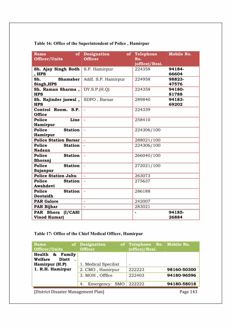
[District Disaster Management Plan] Page 143
Table 16: Office of the Superintendent of Police , Hamirpur
Name of Officer/Units
Designation of Officer
Telephone No. (office)/Resi.
Mobile No.
Sh. Ajay Singh Bodh , HPS
S.P. Hamirpur 224358 94184-66604
Sh. Shamsher Singh,HPS
Addl. S.P. Hamirpur 224958 98823-47576
Sh. Raman Sharma , HPS
DY.S.P.(H.Q) 224358 94180-81788
Sh. Rajinder jaswal , HPS
SDPO , Barsar 289840 94183-69202
Control Room. S.P. Office
- 224339
Police Line Hamirpur
- 258410
Police Station Hamirpur
- 224306/100
Police Station Barsar - 288021/100
Police Station Nadaun
- 224306/100
Police Station Bhoranj
- 266040/100
Police Station Sujanpur
- 272021/100
Police Station Jahu - 263073
Police Station Awahdevi
- 275637
Police Station Deotsidh
- 286188
PAR Galore - 242007
PAR Bijhar - 283021
PAR Bhora (I/CASI Vinod Kumar)
- 94185-26884
Table 17: Office of the Chief Medical Officer, Hamirpur
Name of Officer/Units
Designation of Officer
Telephone No. (office)/Resi.
Mobile No.
Health & Family Welfare Distt . Hamirpur (H.P) 1. R.H. Hamirpur
1. Medical Specilist
-
2. CMO , Hamirpur 222223 98160-50300
3. MOH , Offfice 222403 94180-96596
4. Emergency SMO 222222 94180-58018

[District Disaster Management Plan] Page 144
Office
2. –do- CHC Tauni Devi
BMO , Office 278434 94181-14909
3. –do- CHC Barsar -do- Office 288388 & 288034
94180-37580
4. –do- CHC Bhoranj
-do- Office 266026 94180071143
5. –do- CHC Nadaun
-do- Office 232248 94181-25935
6. –do- CHC Sujanpur
-do- Office 272043,272707 94181-54102
Table 18: Office of the Executive Engineer (C&W) Operation Circle
Name of Office /Institution
Name of Officer
Designation of Officer
Telephone No. (Office ) /Resi.
Mobile No.
HPSEBL Hamirpur
Er. Baldev Chand
A.E. Sub Division No.2 Hamirpur
01972-222218
94180-58013
o/o A.E.Sub Division Nadaun
Er. Arun Sharma
A.E.Sub Div. Nadaun
01972-232226
94184-20001
o/o A.E.Sub Division Barsar
Er. Yashveer Singh Thakur
A.E.Sub Div. Barsar
01972-288023
94180-82255
Table 19: Office of the Commandant Home Guards 10th Battalion, Hamirpur
Name of Office/ Institution
Name of Officer
Designation of Officer
Telephone No (Office/Resi.)
Mobile No.
Fire Brigade Sh. Devi Chand Sharma
Office Incharge Fire Brigade
222533/101 94183-30507
o/o Commanddant Home Guards 10th Battalian Hamirpur
1. Sh. Ramesh Chand
Company Commander
- 94596-49139
2. Sh. Ashok Rangra
Platoon Commander
- 94181-65465
3. Sh. Parvin Kumar
-do- - 98056-56247
Company Sujanpur
Sh. Madan Lal -do- - 97360-46258
Company Nadaun
1.Sh. Surinder Paul 2. Sh. Amrit Lal
Company Commander Platoon Commander
- -
94595-04763
[District Disaster Management Plan] Page 145
94184-50708
Company Bhota
Sh. Nanak Chand
Company Commander
- 94185-32641
Company Barsar
1.Sh. Ashwani Kumar 2. Sanjeev Kumar
1.Senior Company Commander 2.Company Commander
- -
94181-78513 98161-29807
Table 20: Office of the Executive Engineer, IPH Division Barsar.
Name of officer Designation of Officer
Telephone No (Office) /Resi.
Mobile No.
Er. Narender Paul Sharma
Executive Engineer
01972-288060 9418074488
Er. P.C. Sharma A.E. Barsar -do- 9418498199
Er. R.C. Katoch A.E. Bhota - 9418459368
Er.Jitender Kumar Garg
A.E.Galore - 9418473100
Er. Rajesh Kanungo A.E. Bhoranj - 9418073912
Er. Vikram Singh Thakur
J.E. Bijhari - 9418406233
Er. Suresh Kumar Anand
J.E. Chakmoh - 9805130630
Table 21: Office of the Executive Engineer, Hamirpur Division HPPWD, Hamirpur
Name of Office /Institution
Name of Officer
Designation of Officer
Telephone No. (Office ) /Resi.
Mobile No.
Hamirpur Sub Div.
Er. N.P. Singh Executive Engineer
222510/222230 9418137606
Er. Ajay Bhaskar
Asstt. Eng. 225333 9418034555
Er.P.C. Verma -do- 272034 9418046444
Er.Suresh Kumar Walia
-do- 232399 9418471223
Er. Dev Raj Addl. Asstt. Eng.
225333 9418022989
Er. Hari Ram -do- -do- 9418056824
Er. Naresh Jamwal
Jr. Eng. -do- 9817065625
Er. Sanjeev Gautam
-do- -do- 9418028588
[District Disaster Management Plan] Page 146
Er.Ashok Kumar
-do- -do- 9817770325
Sujanpur Sub. Div.
Er. B.D. Rana Addl. –do- 272034 9816726898
Er. Sanjay Kumar
Jr. Eng. -do- 9816218752
Er. Gian Chand
-do- -do- 9418057681
Er. R.K.Saklani
-do- -do- 94180-18371
Nadaun Sub. Div.
Er. Ashok Sharma
Addl.-do- 232399 9418456123
Er. Jeewan Lal Sharma
-do- -do- 9418019629
Er. Ramesh Nanda
-do- -do- 9418138568
Table 22: Office of the Executive Engineer, Barsar Division HPPWD Barsar
Name of Office /Institution
Name of Officer
Designation of Officer
Telephone No. (Office ) /Resi.
Mobile No.
Barsar Sub Div.
Er. Bhag Singh Sem
Asstt. Engineer
01972-2988041
94180-49663
Er. Suresh Kumar
JE - 94184-60175
Er. T.N. Garg -do- - 94182-70460
-do- Dhaneta Er. Deepak Kapil
Asstt. Engineer
- 9418058531
Er. Pawan Kumar
JE - 9816182390
Er. Vinod Kumar
-do- - 9418004010
Er. Vijay Kumar Dhiman
-do- - 9418113700
-do- Bhoranj Er. R.V. Verma
Asstt. Engineer
- 9418457723
Er. Vipan Sharma
JE - 9418383179
Er. Rajesh Kumar
-do- - 9418485072
[District Disaster Management Plan] Page 147
Table 23: Office of the Executive Engineer, Taunidevi Division HPPWD Taunidevi
Name of Office /Institution
Name of Officer
Designation of Officer
Telephone No. (Office ) /Resi.
Mobile No.
Taunidevi Sub Div.
Er. R.K.Sharma
EE 278422 9418103303
Er. B.D.Ruhan
AE 278302 9418047520
Lambloo-do- Er. P.P.Singh -do- 248505 9418417906
Samirpur-do- Er. J.C. Kanungo
-do- 275459 9418023797
Kakkar-do- Er. Hargivind Kaushal
AE to EE Kakkar
- 9816671899
T/Sub Div. Er. Ravi Kumar Jaswal
AAE 278302 9418055015
-do- Er. Rattan Chand
-do- -do- 9418337122
Lambloo-do- Er. Kishore Chand Kamal
AAE 248505 8988387265
-do- Er. Chander Bhanu
JE -do- 9816413644
Table 24: Office of the Animal Husbandry, Hamirpur
Name of Office/ Institution
Name of Officer Designation of Officer
Telephone No (Office/Resi.)
Mobile No.
o/o Deputy Director Animal Health./Breeding
Dr. Y.S. Rathor Deputy Director 01972-222476 94181-13991
Dr. Avinash Kumar Sharma
A.D(Ext.) -do- 94181-03272
Dr.Parvesh kaushal A.D. (Project) -do- 98160-53322
o/o Distt. Statistical officer
Sg. Tarlok Chand Distt. Statistical Officer
01972-222397 94180-18231
Table 25: Status of Gosadans in respect of District Hamirpur
Name & Address Of the Gosadan
Name and Address with Tel. No & the NGO managing the Gosadan
Te. No./Mobile No.
Land Available
Carrying Capacity
Present Strength
1. 2. 3. 4. 5. 6.
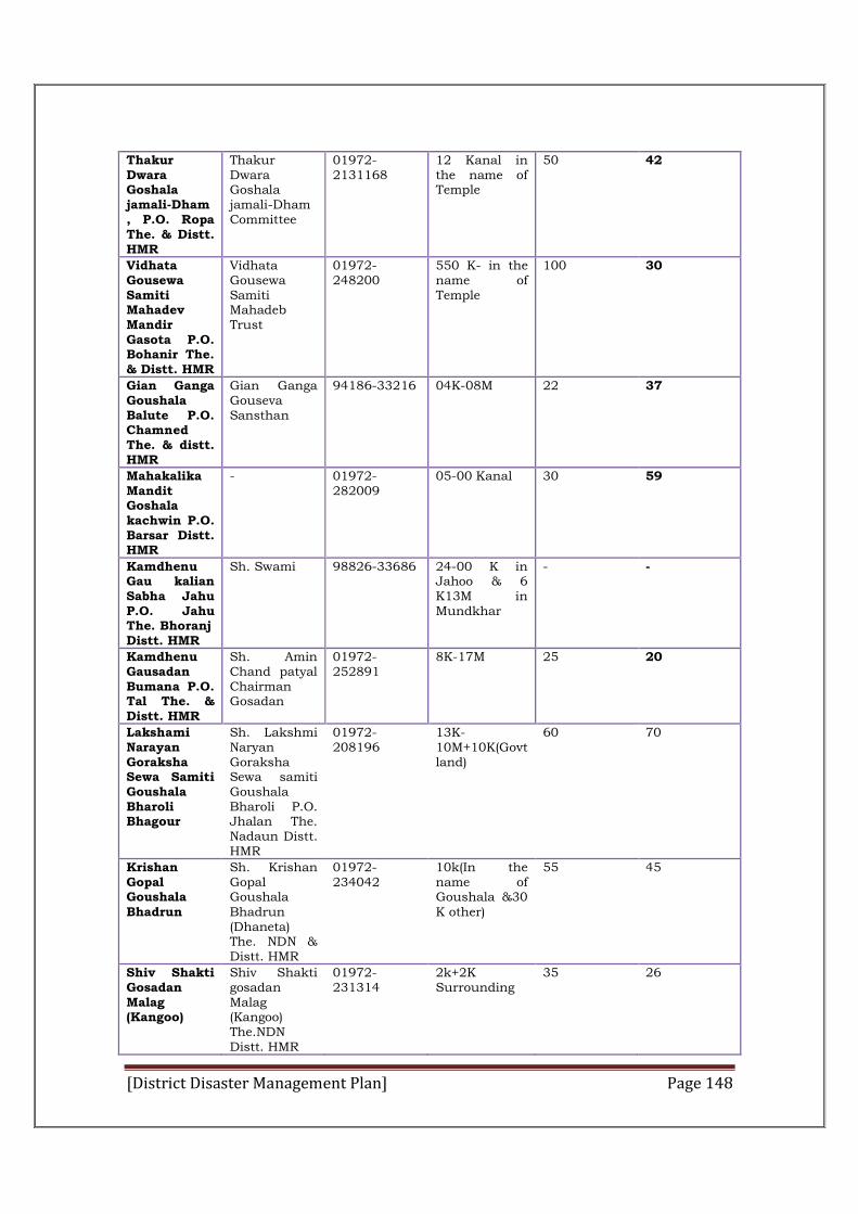
[District Disaster Management Plan] Page 148
Thakur Dwara Goshala jamali-Dham , P.O. Ropa The. & Distt. HMR
Thakur Dwara Goshala jamali-Dham Committee
01972-2131168
12 Kanal in the name of Temple
50 42
Vidhata Gousewa Samiti Mahadev Mandir Gasota P.O. Bohanir The. & Distt. HMR
Vidhata Gousewa Samiti Mahadeb Trust
01972-248200
550 K- in the name of Temple
100 30
Gian Ganga Goushala Balute P.O. Chamned The. & distt. HMR
Gian Ganga Gouseva Sansthan
94186-33216 04K-08M 22 37
Mahakalika Mandit Goshala kachwin P.O. Barsar Distt. HMR
- 01972-282009
05-00 Kanal 30 59
Kamdhenu Gau kalian Sabha Jahu P.O. Jahu The. Bhoranj Distt. HMR
Sh. Swami 98826-33686 24-00 K in Jahoo & 6 K13M in Mundkhar
- -
Kamdhenu Gausadan Bumana P.O. Tal The. & Distt. HMR
Sh. Amin Chand patyal Chairman Gosadan
01972-252891
8K-17M 25 20
Lakshami Narayan Goraksha Sewa Samiti Goushala Bharoli Bhagour
Sh. Lakshmi Naryan Goraksha Sewa samiti Goushala Bharoli P.O. Jhalan The. Nadaun Distt. HMR
01972-208196
13K-10M+10K(Govt land)
60 70
Krishan Gopal Goushala Bhadrun
Sh. Krishan Gopal Goushala Bhadrun (Dhaneta) The. NDN & Distt. HMR
01972-234042
10k(In the name of Goushala &30 K other)
55 45
Shiv Shakti Gosadan Malag (Kangoo)
Shiv Shakti gosadan Malag (Kangoo) The.NDN Distt. HMR
01972-231314
2k+2K Surrounding
35 26
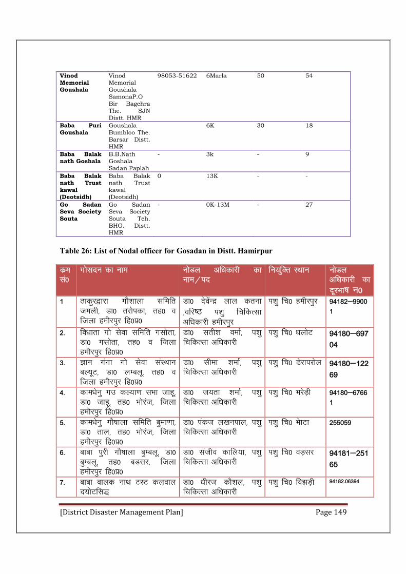
[District Disaster Management Plan] Page 149
Vinod Memorial Goushala
Vinod Memorial Goushala SamonaP.O Bir Bagehra The. SJN Distt. HMR
98053-51622 6Marla 50 54
Baba Puri Goushala
Goushala Bumbloo The. Barsar Distt. HMR
6K 30 18
Baba Balak nath Goshala
B.B.Nath Goshala Sadan Paplah
- 3k - 9
Baba Balak nath Trust kawal (Deotsidh)
Baba Balak nath Trust kawal (Deotsidh)
0 13K - -
Go Sadan Seva Society Souta
Go Sadan Seva Society Souta Teh. BHG. Distt. HMR
- 0K-13M - 27
Table 26: List of Nodal officer for Gosadan in Distt. Hamirpur
dze la0
xkslnu dk uke uksMy vf/kdkjh dk uke@in
fu;fqDr LFkku uksMy vf/kdkjh dk nwjHkk"k u0
1 Bkdqj}kjk xkS”kkyk lfefr teyh] Mk0 rjksidk] rg0 o ftyk gehjiqj fg0iz0
Mk0 nsosaUnz yky druk ]ofj"B i'kq fpfdRlk vf/kdkjh gehjiqj
Ik”kq fp0 gehjiqj 94182&99001
2- fo/kkrk xks lsok lfefr xlksrk] Mk0 xlksrk] rg0 o ftyk gehjiqj fg0iz0
Mk0 lrh”k oekZ] i'kq fpfdRlk vf/kdkjh
Ik”kq fp0 /kyksV 94180&69704
3- Kku xaxk xks lsok laLFkku cY;wV] Mk0 yEcyw] rg0 o ftyk gehjiqj fg0iz0
Mk0 lhek ”kekZ] i'kq fpfdRlk vf/kdkjh
Ik”kq fp0 Msjkijksy 94180&12269
4- dke/ksuq xm dY;k.k lHkk tkgw] Mk0 tkgw] rg0 Hkksjat] ftyk gehjiqj fg0iz0
Mk0 t;rk “kekZ] i'kq fpfdRlk vf/kdkjh
Ik”kq fp0 HkjsM+h 94180&67661
5- dke/ksuq xkS’kkyk lfefr cqek.kk] Mk0 rky] rg0 Hkksjat] ftyk gehjiqj fg0iz0
Mk0 iadt y[kuiky] i'kq fpfdRlk vf/kdkjh
Ik”kq fp0 HkskVk 255059
6- Ckkck iqjh xkS’kkyk cqEcyw] Mk0 cqEcyw] rg0 cMlj] ftyk gehjiqj fg0iz0
Mk0 latho dkfy;k] i'kq fpfdRlk vf/kdkjh
Ik”kq fp0 oM+lj 94181&25165
7- ckck okyd ukFk VLV dyoky n;ksVfl)
Mk0 /khjt dkS”ky] i'kq fpfdRlk vf/kdkjh
Ik”kq fp0 fo>M+h 94182-06394
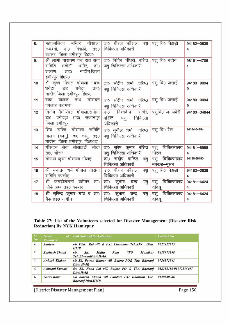
[District Disaster Management Plan] Page 150
8- egkdkfydk efUnj xkS”kkyk dPNoha] Mk0 fc>M+h] rg0 cMlj] ftyk gehjiqj fg0iz0
Mk0 /khjt dkS”ky] i'kq fpfdRlk vf/kdkjh
Ik”kq fp0 fo>M+h 94182&06394
9- Jh y{eh ukjk;.k xm j{kk lsok lfefr HkMksyh HkxkSj] Mk0 >yk.k] rg0 uknkSu]ftyk gehjiqj fg0iz0
Mk0 fofiu pkS/kjh] ofj"B i'kq fpfdRlk vf/kdkjh
Ik”kq fp0 unkSu 98161&47061
10 Jh d`".k xksiky xkS’kkyk Hkn:a /kusVk] Mk0 /kusVk] rg0 uknkSu]ftyk gehjiqj fg0iz0
Mk0 lanhi “kekZ] ofj"B i'kq fpfdRlk vf/kdkjh
Ik”kq fp0 tlkbZ 94180&90949
11 ckck okyd ukFk xkslnu iiykg ogkze.kk
Mk0 lanhi “kekZ] ofj"B i'kq fpfdRlk vf/kdkjh
Ik”kq fp0 tlkbZ 94180&90949
12 fouksn eSeksfj;y xks’kkyk]leksuk Mk0 oxsgM+k rg0 lqtkuiqj ftyk gehjiqj
Mk0 fo”onhi jkBkSj] ofj"B i'kq fpfdRlk vf/kdkjh
Ik”kqfp0 taxyosjh 94180&34844
13 f”ko 'kfDr xkS”kkyk lfefr ekyx (dkaxq)] Mk0 dkaxq] rg0 uknkSu] ftyk gehjiqj (fg0iz0)
Mk0 lquhy “kekZ ofj"B i'kq fpfdRlk vf/kdkjh
Ik”kq fp0 jSy 94184-64784
14 xkSlnu lsok lkslkbVh lkSVk rg0 Hkksajt
Mk0 lqjs’k dqekj cfj"B Ik”kq fpfdRlk vf/kdkjh
Ik”kq fpfdRlky; Hkksjt
94181&69884
15 xksiky d`".k xkS”kkyk xksyg Mk0 lanhi ikfVy Ik”kq fpfdRlk vf/kdkjh
Ik”kq fpfdRlky; eDdM&ewlu
94180-66490
16 Jh lukru /keZ xksiky xkslsok lfefr iiyksg
Mk0 /khjt dkS”ky] i'kq fpfdRlk vf/kdkjh
Ik”kq fp0 fo>M+h 94182&06394
17 Jh txnh”k“kekZ o<hrj Mk0 tkSMs vEc rg0 cMlj
Mk0 lqHkk"k pUn i’kq fpfdRlk vf/kdkjh
Ik”kq fpfdRlky; nkanMw
94181&64244
18 Jh lqfjUnz dqekj xkao o Mk0 eSM rg0 uknkSu
Mk0 lqHkk"k pUn Ik”kq fpfdRlk vf/kdkjh
Ik”kq fpfdRlky; nkanMw
94181&64244
Table 27: List of the Volunteers selected for Disaster Management (Disaster Risk Reduction) By NYK Hamirpur
Sr. No.
Name of Volunteer
Full Name of the Volunteer Contact No.
1. Sanjeev s/o Tilak Raj vill. & P.O. Chamiana Teh.SJN . Distt. HMR
9625422815
2. Subhash Chand s/o Sh. Mallu Ram VPO Mundkar Teh.BhoranjDistt.HMR
9418973898
3. Ankush Thakur s/o Sh. Pawan Kumar vill. Balore PO& The. Bhoranj Distt. HMR
9736572541
4. Ashwani Kumari d/o Sh. Nand Lal vill. Balore PO & The. Bhoranj Distt.HMR
988212130/01972315497
5. Gorav Rana s/o Suresh Chand vill Lundari P.O Dhanwin The. Bhoranj Distt.HMR
9129640286
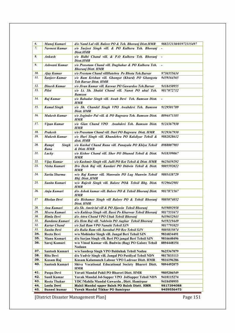
[District Disaster Management Plan] Page 151
6. Manoj Kumari d/o Nand Lal vill. Balore PO & Teh. Bhoranj Distt.HMR 988212130/01972315497 7. Navneet Kumar s/o Surjeet Singh vill. & PO Kulhera Teh. Bhoranj
Distt.HMR -
8. Ankush s/o Bidhi Chand vill. & P.O Kulhera Teh. Bhoranj Distt.HMR
-
9. Ashwani Kumar s/o Prasotam Chand vill. Dughahar & PO Kulhera Teh. Bhoranj Distt. HMR
-
10. Ajay Kumar s/o Preetam Chand villHatehra Po Bhota Teh.Barsar 9736555634 11. Sanjeev Kumar s/o Ram Krishan vill. Ghangot (Khurd) PO Ghangota
Teh Barsar Distt. HMR 9459164565
12. Dinesh Kumar s/o Jivan Kumar vill. Kaswar PO Gawardoo Teh.Barsar 9418450955 13. Pilot s/o Lt. Sh. Shakti Chand vill. Nanot PO uhal Teh.
Bamson 9817072712
14. Raj Kumar s/o Bahadur Singh vill. Awah Devi Teh. Bamson Distt. HMR
-
15. Kamal Singh s/o Sh. Chandel Singh VPO Awahdevi Teh. Bamson Distt. HMR
9129501709
16. Mukesh Kumar s/o Joginder Pal vill. & PO Bagwara Teh. Bamson Distt. HMR
8894471185
17. Vipan Kumar s/o Gian Chand VPO Awahdevi Teh. Bamson Distt. HMR
9124367930
18. Prakesh s/o Prasotam Chand vill. Dari PO Bagwara Distt. HMR 9129367930 19. Mukesh Kumar s/o Hari Singh vill. Khandehra PO Kakdiyar Tehsil &
distt. HMR 9882828612
20. Rampi Singh Rana
s/o Kushal Chand Rana vill. Panayala PO Khiya Tehsil & Distt. HMR
8988007903
21. Lucky s/o Kishor Chand vill. Sher PO Dhaned Tehsil & Distt. HMR
9418399067
22. Vijay Kumar s/o Kashmir Singh vill. Julli PO Kot Tehsil & Distt. HMR 9625659292 23. Nisha Kumari D/o Desh Raj vill. Kandari PO Didwin Tehsil & Distt.
HMR 9805592022
24. Sarita Sharma w/o Raj Kumar vill. Manwain PO Lag Manwin Tehsil Bhj. Distt.,HMR
9805438729
25. Sunita Kumari w/o Rajesh Singh vill. Balore PO& Tehsil Bhg. Distt. HMR
9129642981
26. Anju Kumari d/o Ashok kumar vill. Balore PO & Tehsil Bhoranj Distt. HMR
9817871567
27 Bholan Devi d/o Bishamer Singh vill Balore PO & Tehsil Bhoranj Distt. HMR
9805074052
28. Anu Kumari d/o Sh. Amrit lal vill & PO Jijawin Tehsil Bhoranj 9459892958 29. Meera Kumari w/o Kuldeep Singh vill. Bassi Po Kharwar Tehsil Bhoranj 9817551673 30. Bimla Devi d/o Attru Chand VPO Uhak Tehsil Bhoranj 9459652943 31. Bandana Kumari d/o Hem Raj vill. Nahlwin PO Aaghar Tehsil Bhoranj 9459219449 32. Kartar Chand s/o Sail Ram VPO Nanahi Tehsil SJN 9817791025 33. Sunita Devi d/o Rulia Ram vill. Sawahal PO Ree Tehsil SJN 9805835074 34. Reeta Devi w/o Mohinder Singh vill. Jangal Beri Tehsil SJN 9816834491 35. Manu Kumari d/o Surjan Singh vill. Beri PO jangal Beri Tehsil SJN 9816640496 36. Saroj Kumari w/o Vinod Kumar vill. Budwin (Bag) PO Galore Tehsil
Nadaun 8894448154
37. Santosh Kumari w/o Sandeep Singh VPO Balduhak Tehsil Nadau 9625367079 38. Rita Devi d/o Yudvir Singh vill. Jangal PO Putdiyal Tehsil NDN 9817833113 39. Kusam Raj Kusam Kalamunch Labour VPO Ladrour Distt. HMR 9816196286 40. Santosh Kumari Shiva Vocational Educational Society Bhareri Distt.
HMR 9894492075
41. Puspa Devi Yuvati Mandal Pahil PO Bhareri Distt. HMR 9805206549 42. Sunil Kumar Yuvak Mandal Jol-Sapper VPO JolSapper Tehsil NDN 9418115274 43. Reeta Thakur YDC/Mahila Mandal Gawardu , Distt. Hamirpur 9418450955 44. Leela Devi Mahil Mandal upper Baloh PO Baloh Distt. HMR 9817394088
45. Suneel kumar Yuvak Mandal Tikkar PO Samirpur 9459556473
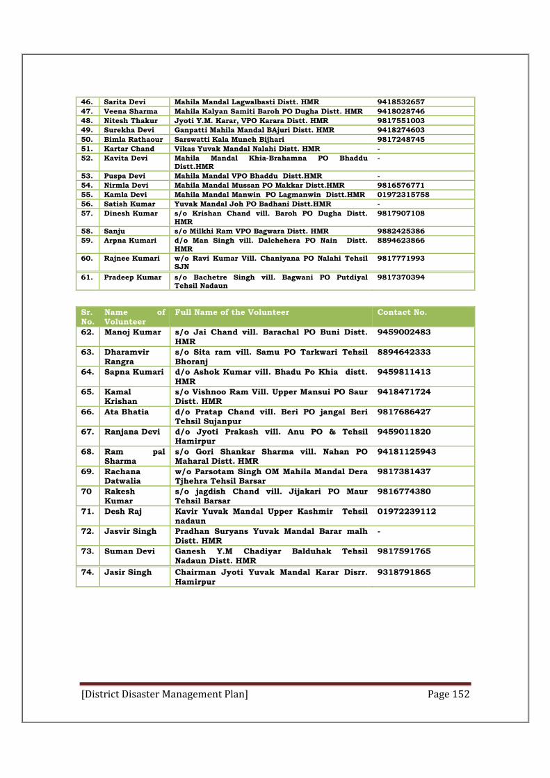
[District Disaster Management Plan] Page 152
46. Sarita Devi Mahila Mandal Lagwalbasti Distt. HMR 9418532657
47. Veena Sharma Mahila Kalyan Samiti Baroh PO Dugha Distt. HMR 9418028746
48. Nitesh Thakur Jyoti Y.M. Karar, VPO Karara Distt. HMR 9817551003
49. Surekha Devi Ganpatti Mahila Mandal BAjuri Distt. HMR 9418274603
50. Bimla Rathaour Sarswatti Kala Munch Bijhari 9817248745
51. Kartar Chand Vikas Yuvak Mandal Nalahi Distt. HMR -
52. Kavita Devi Mahila Mandal Khia-Brahamna PO Bhaddu Distt.HMR
-
53. Puspa Devi Mahila Mandal VPO Bhaddu Distt.HMR -
54. Nirmla Devi Mahila Mandal Mussan PO Makkar Distt.HMR 9816576771
55. Kamla Devi Mahila Mandal Manwin PO Lagmanwin Distt.HMR 01972315758
56. Satish Kumar Yuvak Mandal Joh PO Badhani Distt.HMR -
57. Dinesh Kumar s/o Krishan Chand vill. Baroh PO Dugha Distt. HMR
9817907108
58. Sanju s/o Milkhi Ram VPO Bagwara Distt. HMR 9882425386
59. Arpna Kumari d/o Man Singh vill. Dalchehera PO Nain Distt. HMR
8894623866
60. Rajnee Kumari w/o Ravi Kumar Vill. Chaniyana PO Nalahi Tehsil SJN
9817771993
61. Pradeep Kumar s/o Bachetre Singh vill. Bagwani PO Putdiyal Tehsil Nadaun
9817370394
Sr. No.
Name of Volunteer
Full Name of the Volunteer Contact No.
62. Manoj Kumar s/o Jai Chand vill. Barachal PO Buni Distt. HMR
9459002483
63. Dharamvir Rangra
s/o Sita ram vill. Samu PO Tarkwari Tehsil Bhoranj
8894642333
64. Sapna Kumari d/o Ashok Kumar vill. Bhadu Po Khia distt. HMR
9459811413
65. Kamal Krishan
s/o Vishnoo Ram Vill. Upper Mansui PO Saur Distt. HMR
9418471724
66. Ata Bhatia d/o Pratap Chand vill. Beri PO jangal Beri Tehsil Sujanpur
9817686427
67. Ranjana Devi d/o Jyoti Prakash vill. Anu PO & Tehsil Hamirpur
9459011820
68. Ram pal Sharma
s/o Gori Shankar Sharma vill. Nahan PO Maharal Distt. HMR
94181125943
69. Rachana Datwalia
w/o Parsotam Singh OM Mahila Mandal Dera Tjhehra Tehsil Barsar
9817381437
70 Rakesh Kumar
s/o jagdish Chand vill. Jijakari PO Maur Tehsil Barsar
9816774380
71. Desh Raj Kavir Yuvak Mandal Upper Kashmir Tehsil nadaun
01972239112
72. Jasvir Singh Pradhan Suryans Yuvak Mandal Barar malh Distt. HMR
-
73. Suman Devi Ganesh Y.M Chadiyar Balduhak Tehsil Nadaun Distt. HMR
9817591765
74. Jasir Singh Chairman Jyoti Yuvak Mandal Karar Disrr. Hamirpur
9318791865
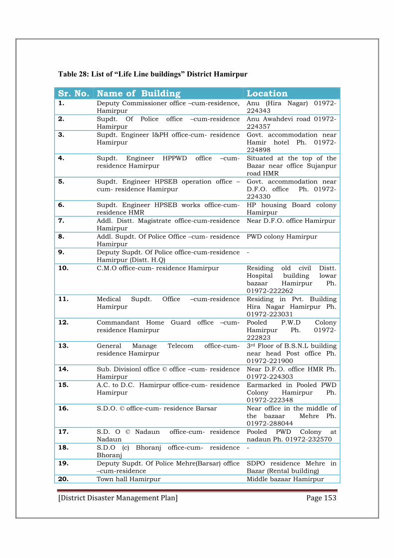
[District Disaster Management Plan] Page 153
Table 28: List of “Life Line buildings” District Hamirpur
Sr. No. Name of Building Location 1. Deputy Commissioner office –cum-residence,
Hamirpur Anu (Hira Nagar) 01972-224343
2. Supdt. Of Police office –cum-residence Hamirpur
Anu Awahdevi road 01972-224357
3. Supdt. Engineer I&PH office-cum- residence Hamirpur
Govt. accommodation near Hamir hotel Ph. 01972-224898
4. Supdt. Engineer HPPWD office –cum- residence Hamirpur
Situated at the top of the Bazar near office Sujanpur road HMR
5. Supdt. Engineer HPSEB operation office –cum- residence Hamirpur
Govt. accommodation near D.F.O. office Ph. 01972-224330
6. Supdt. Engineer HPSEB works office-cum-residence HMR
HP housing Board colony Hamirpur
7. Addl. Distt. Magistrate office-cum-residence Hamirpur
Near D.F.O. office Hamirpur
8. Addl. Supdt. Of Police Office –cum- residence Hamirpur
PWD colony Hamirpur
9. Deputy Supdt. Of Police office-cum-residence Hamirpur (Distt. H.Q)
-
10. C.M.O office-cum- residence Hamirpur Residing old civil Distt. Hospital building lowar bazaar Hamirpur Ph. 01972-222262
11. Medical Supdt. Office –cum-residence Hamirpur
Residing in Pvt. Building Hira Nagar Hamirpur Ph. 01972-223031
12. Commandant Home Guard office –cum-residence Hamirpur
Pooled P.W.D Colony Hamirpur Ph. 01972-222823
13. General Manage Telecom office-cum- residence Hamirpur
3rd Floor of B.S.N.L building near head Post office Ph. 01972-221900
14. Sub. Divisionl office © office –cum- residence Hamirpur
Near D.F.O. office HMR Ph. 01972-224303
15. A.C. to D.C. Hamirpur office-cum- residence Hamirpur
Earmarked in Pooled PWD Colony Hamirpur Ph. 01972-222348
16. S.D.O. © office-cum- residence Barsar Near office in the middle of the bazaar Mehre Ph. 01972-288044
17. S.D. O © Nadaun office-cum- residence Nadaun
Pooled PWD Colony at nadaun Ph. 01972-232570
18. S.D.O (c) Bhoranj office-cum- residence Bhoranj
-
19. Deputy Supdt. Of Police Mehre(Barsar) office –cum-residence
SDPO residence Mehre in Bazar (Rental building)
20. Town hall Hamirpur Middle bazaar Hamirpur
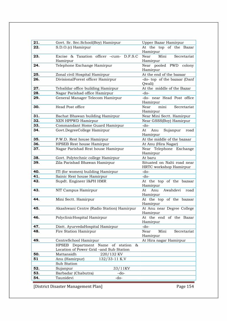
[District Disaster Management Plan] Page 154
21. Govt. Sr. Sec.School(Boy) Hamirpur Upper Bazar Hamirpur
22. S.D.O.(c) Hamirpur At the top of the Bazar Hamirpur
23. Excise & Taxation officer –cum- D.F.S.C Hamirpur
Near Mini Secretariat Hamirpur
24. Telephone Exchange Hamirpur Near pooled PWD colony Hamirpur
25. Zonal civil Hospital Hamirpur At the end of the bazaar
26. DivisionalForest officer Hamirpur -do- top of the bazaar (Danf Qwali)
27. Tehsildar office building Hamirpur At the middle of the Bazar
28. Nagar Parishad office Hamirpur -do-
29. General Manager Telecom Hamirpur -do- near Head Post office Hamirpur
30. Head Post office Near mini Secretariat Hamirpur
31. Bachat Bhawan building Hamirpur Near Mini Sectt. Hamirpur
32. XEN HPPWD Hamirpur Near GSSS(Boy) Hamirpur
33. Commandant Home Guard Hamirpur -do-
34. Govt.DegreeCollege Hamirpur At Anu Sujanpur road Hamirpur
35. P.W.D. Rest house Hamirpur At the middle of the bazaar
36. HPSEB Rest house Hamirpur At Anu (Hira Nagar)
37. Nagar Parishad Rest house Hamirpur Near Telephone Exchange Hamirpur
38. Govt. Polytechnic college Hamirpur At baru
39. Zila Parishad Bhawan Hamirpur Situated on Nalti road near HRTC workshop Hamirpur
40. ITI (for women) building Hamirpur -do-
41. Sainic Rest house Hamirpur -do-
42. Supdt. Engineer I&PH HMR At the top of the bazaar Hamirpur
43. NIT Campus Hamirpur At Anu Awahdevi road Hamirpur
44. Mini Sectt. Hamirpur At the top of the bazaar Hamirpur
45. Akashwani Centre (Radio Station) Hamirpur At Anu near Degree College Hamirpur
46. PolyclinicHospital Hamirpur At the end of the Bazar Hamirpur
47. Distt. AyurvedaHospital Hamirpur -do-
48. Fire Station Hamirpur Near Mini Secretariat Hamirpur
49. CentreSchool Hamirpur At Hira nagar Hamirpur
HPSEB Department Name of station & Location of Power Grid –and Sub Station
50. Mattansidh 220/132 KV
51 Anu (Hamirpur) 132/33-11 K.V
Sub Station
52. Sujanpur 33/11KV
53. Barbadar (Chabutra) –do-
54. Taunidevi -do-
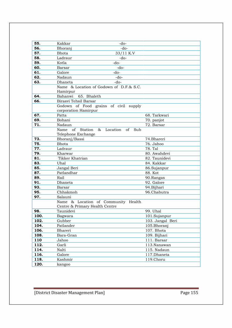
[District Disaster Management Plan] Page 155
55. Kakkar -do-
56. Bhoranj -do-
57. Bhota 33/11 K.V
58. Ladraur -do-
59. Kotla -do-
60. Barsar -do-
61. Galore -do-
62. Nadaun -do-
63. Dhaneta -do-
Name & Location of Godown of D.F.& S.C. Hamirpur
64. Bahanwi 65. Bhaleth
66. Birasvi Tehsil Barsar
Godown of Food grains of civil supply corporation Hamirpur
67. Patta 68. Tarkwari
69. Bohani 70. panjot
71. Nadaun 72. Barsar
Name of Station & Location of Sub Telephone Exchange
73. Bhoranj/Bassi 74.Bhareri
75. Bhota 76. Jahoo
77. Ladraur 78. Tal
79. Kharwar 80. Awahdevi
81. Tikker Khatrian 82. Taunidevi
83. Uhal 84. Kakkar
85. Jangal Beri 86.Sujanpur
87. Patlandhar 88. Kot
89. Rail 90.Rangas
91. Dhaneta 92. Galore
93. Barsar 94.Bijhari
95. Chhakmoh 96.Chabutra
97. Salauni
Name & Location of Community Health Centre & Primary Health Centre
98. Taunidevi 99. Uhal
100. Bagwara 101.Sujanpur
102. Gubber 103. Jangal Beri
104. Patlander 105.Bhoranj
106. Bhareri 107. Bhota
108. Bara-Gran 109. Bijhari
110 Jahoo 111. Barsar
112. Garli 113.Nanawan
114. Nalti 115. Nadaun
116. Galore 117.Dhaneta
118. Kashmir 119.Choru
120. kangoo

[District Disaster Management Plan] Page 156
Table 29: Helicopter Request
For Aircraft/Helicopter Requisitioning at Disaster Time
Wing Commander Vineet Sharma , Chief Operation Officer
Air Force Station Sarsawa-247232, Saharanpur (U.P)
Mobile: 07599342240, Phone 01331-244822,01331-245280
E-Mail: vinysim@gmail .com
[District Disaster Management Plan] Page 157
ANNEXURE
District Disaster Resource Inventory
Disaster Response Resource Inventory
Disaster Response Resource Inventory refers to the resources available
within the jurisdiction and these resources will easily available during any
crisis in this district. For such purpose nationwide data base portal has
developed by National Institute of Disaster Management i.e. Indian Disaster
Resource Network (IDRN).
IDRN utilized through district and data updated through web portal, IDRN
consist online data base of equipments, skilled men power and critical supplies.
These data base can be utilizes at the equipments, skilled men power and
critical supplies. These data base can be utilizes at the time of crisis; the hard
copy of updated equipment related details is having with DEOC separately. For
utilization of the same anyone can use the link www.idrn.gov.in
Role of District ADCinistration
1. District Emergency Operation Centre, Hamirpur is overall in charge of
updating the resource inventory.
2. Every department in the district has been provided with individual
username and password for data updation on the website.
3. Every department should nominate Nodal Officer for the Disaster
Management and this inventory is updated under the guidance of Nodal
Officer. During the time of record entries in the system following has to
be checked by
a.) Quality of Data
b.) Maintenance of Hard Copies
c.) Monitoring & Usage of Hard Copies
4. Every department of this district is own responsible for updation of
resource inventory timely on the portal.

[District Disaster Management Plan] Page 158
5. Resource Inventory data is updated within every 3 months by the
departments or whenever seems necessary.
Resource Inventory Available in the district
Office of the Superintendent of Police, District- Hamirpur
Himachal Pradesh.
Nodal Officer: - Sh. Lal Man Sharma
Contact No. : - Mobile No. 9418077169; Phone No. 224338
Fax No. 222053; Email Id: - [email protected]
Sr. no Item Name Qu Quality Available
1. C Circular Saw with Diamond Blade (electric)
01
2 . Sl Sledge Hammer 03 3. Heavy Axe 01
4. Set of Rope tackle (3 sheave- 2 sheave) 02
5. Blankets 02
6. Helmet 50
7. Axe 01
8. Public Address System 02
9. Rope 02
10. Bucket 02
11. I Inflatable Light Tower 01
12. Electric Generator 02
13. Extension Ladder 01
14. Aluminium Ladder 01
15. VHF Sets static 15
16. VHF Sets Mobile 32
17. W Walkie Talkies Sets 43 18. HF Sets Static 16
19. C Cranes- Heavy Duty, fork type 01
20. 4 Wheel Drive Vehicle 06
21. Motor Cycle 19
22. Truck 01
23. Mini Bus 01
24. Bus 01
Police Stations and available of Staff.
Sr.No Location of Police Station
Name of Officer Contact No.
Nos of Staff Available
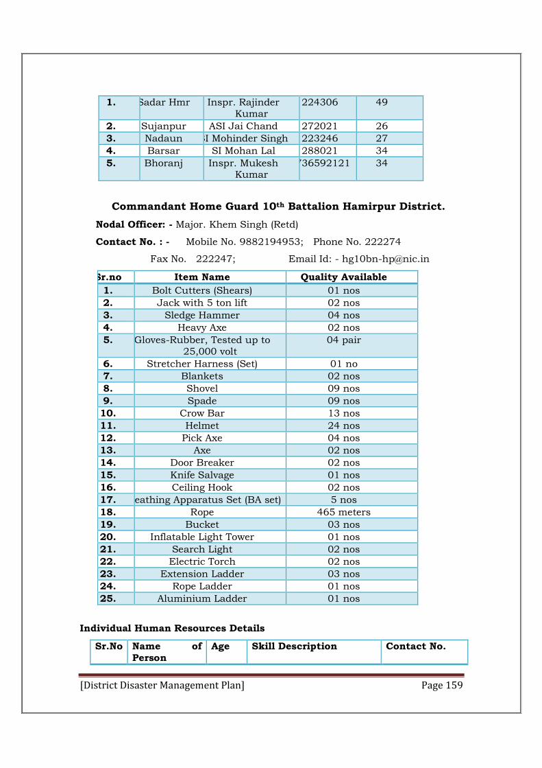
[District Disaster Management Plan] Page 159
1. Sadar Hmr Inspr. Rajinder Kumar
224306 49
2. Sujanpur ASI Jai Chand 272021 26
3. Nadaun SI Mohinder Singh 223246 27
4. Barsar SI Mohan Lal 288021 34
5. Bhoranj Inspr. Mukesh Kumar
9736592121 34
Commandant Home Guard 10th Battalion Hamirpur District.
Nodal Officer: - Major. Khem Singh (Retd)
Contact No. : - Mobile No. 9882194953; Phone No. 222274
Fax No. 222247; Email Id: - [email protected]
Sr.no Item Name Quality Available
1. Bolt Cutters (Shears) 01 nos
2. Jack with 5 ton lift 02 nos
3. Sledge Hammer 04 nos
4. Heavy Axe 02 nos
5. Gloves-Rubber, Tested up to 25,000 volt
04 pair
6. Stretcher Harness (Set) 01 no
7. Blankets 02 nos
8. Shovel 09 nos
9. Spade 09 nos
10. Crow Bar 13 nos
11. Helmet 24 nos
12. Pick Axe 04 nos
13. Axe 02 nos
14. Door Breaker 02 nos
15. Knife Salvage 01 nos
16. Ceiling Hook 02 nos
17. Breathing Apparatus Set (BA set) 5 nos
18. Rope 465 meters
19. Bucket 03 nos
20. Inflatable Light Tower 01 nos
21. Search Light 02 nos
22. Electric Torch 02 nos
23. Extension Ladder 03 nos
24. Rope Ladder 01 nos
25. Aluminium Ladder 01 nos
Individual Human Resources Details
Sr.No Name of Person
Age Skill Description Contact No.
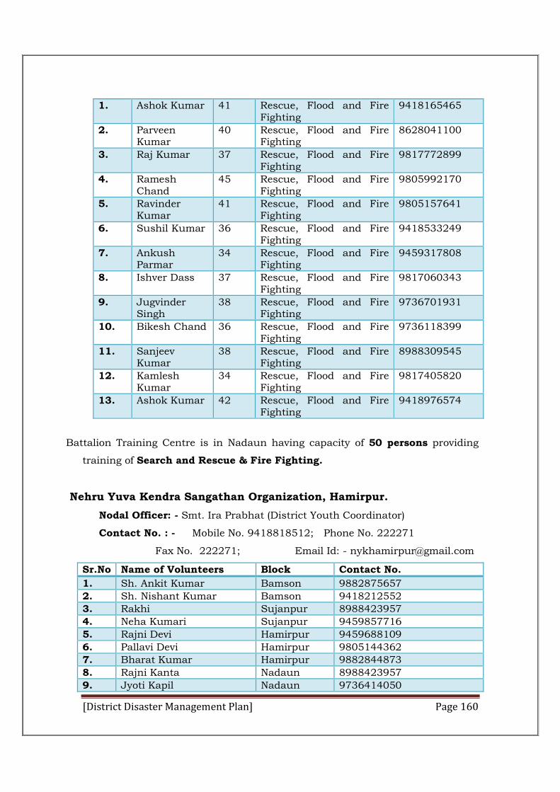
[District Disaster Management Plan] Page 160
1. Ashok Kumar 41 Rescue, Flood and Fire Fighting
9418165465
2. Parveen Kumar
40 Rescue, Flood and Fire Fighting
8628041100
3. Raj Kumar 37 Rescue, Flood and Fire Fighting
9817772899
4. Ramesh Chand
45 Rescue, Flood and Fire Fighting
9805992170
5. Ravinder Kumar
41 Rescue, Flood and Fire Fighting
9805157641
6. Sushil Kumar 36 Rescue, Flood and Fire Fighting
9418533249
7. Ankush Parmar
34 Rescue, Flood and Fire Fighting
9459317808
8. Ishver Dass 37 Rescue, Flood and Fire Fighting
9817060343
9. Jugvinder Singh
38 Rescue, Flood and Fire Fighting
9736701931
10. Bikesh Chand 36 Rescue, Flood and Fire Fighting
9736118399
11. Sanjeev Kumar
38 Rescue, Flood and Fire Fighting
8988309545
12. Kamlesh Kumar
34 Rescue, Flood and Fire Fighting
9817405820
13. Ashok Kumar 42 Rescue, Flood and Fire Fighting
9418976574
Battalion Training Centre is in Nadaun having capacity of 50 persons providing
training of Search and Rescue & Fire Fighting.
Nehru Yuva Kendra Sangathan Organization, Hamirpur.
Nodal Officer: - Smt. Ira Prabhat (District Youth Coordinator)
Contact No. : - Mobile No. 9418818512; Phone No. 222271
Fax No. 222271; Email Id: - [email protected]
Sr.No Name of Volunteers Block Contact No.
1. Sh. Ankit Kumar Bamson 9882875657
2. Sh. Nishant Kumar Bamson 9418212552
3. Rakhi Sujanpur 8988423957
4. Neha Kumari Sujanpur 9459857716
5. Rajni Devi Hamirpur 9459688109
6. Pallavi Devi Hamirpur 9805144362
7. Bharat Kumar Hamirpur 9882844873
8. Rajni Kanta Nadaun 8988423957
9. Jyoti Kapil Nadaun 9736414050
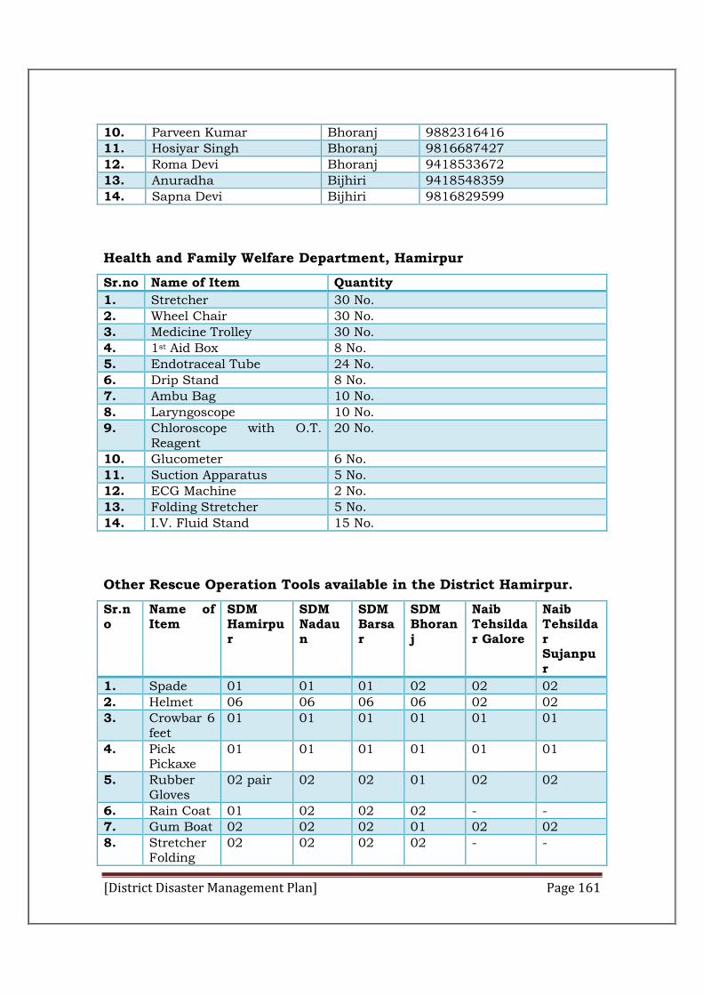
[District Disaster Management Plan] Page 161
10. Parveen Kumar Bhoranj 9882316416
11. Hosiyar Singh Bhoranj 9816687427
12. Roma Devi Bhoranj 9418533672
13. Anuradha Bijhiri 9418548359
14. Sapna Devi Bijhiri 9816829599
Health and Family Welfare Department, Hamirpur
Sr.no Name of Item Quantity
1. Stretcher 30 No.
2. Wheel Chair 30 No.
3. Medicine Trolley 30 No.
4. 1st Aid Box 8 No.
5. Endotraceal Tube 24 No.
6. Drip Stand 8 No.
7. Ambu Bag 10 No.
8. Laryngoscope 10 No.
9. Chloroscope with O.T. Reagent
20 No.
10. Glucometer 6 No.
11. Suction Apparatus 5 No.
12. ECG Machine 2 No.
13. Folding Stretcher 5 No.
14. I.V. Fluid Stand 15 No.
Other Rescue Operation Tools available in the District Hamirpur.
Sr.no
Name of Item
SDM Hamirpur
SDM Nadaun
SDM Barsar
SDM Bhoranj
Naib Tehsildar Galore
Naib Tehsildar Sujanpur
1. Spade 01 01 01 02 02 02
2. Helmet 06 06 06 06 02 02
3. Crowbar 6 feet
01 01 01 01 01 01
4. Pick Pickaxe
01 01 01 01 01 01
5. Rubber Gloves
02 pair 02 02 01 02 02
6. Rain Coat 01 02 02 02 - -
7. Gum Boat 02 02 02 01 02 02
8. Stretcher Folding
02 02 02 02 - -
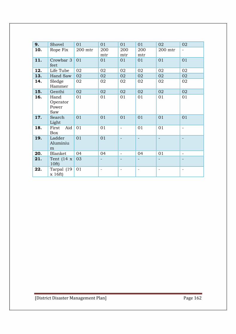
[District Disaster Management Plan] Page 162
9. Shovel 01 01 01 01 02 02
10. Rope Fix 200 mtr 200 mtr
200 mtr
200 mtr
200 mtr -
11. Crowbar 3 feet
01 01 01 01 01 01
12. Life Tube 02 02 02 02 02 02
13. Hand Saw 02 02 02 02 02 02
14. Sledge Hammer
02 02 02 02 02 02
15. Genthi 02 02 02 02 02 02
16. Hand Operator Power Saw
01 01 01 01 01 01
17. Search Light
01 01 01 01 01 01
18. First Aid Box
01 01 - 01 01 -
19. Ladder Aluminium
01 01 - - - -
20. Blanket 04 04 - 04 01 -
21. Tent (14 x 10ft)
03 - - - - -
22. Tarpal (19 x 16ft)
01 - - - - -
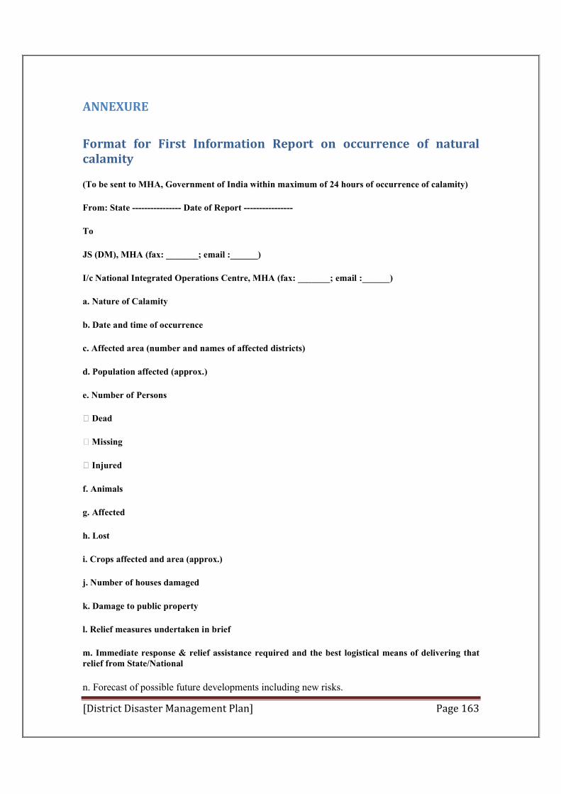
[District Disaster Management Plan] Page 163
ANNEXURE
Format for First Information Report on occurrence of natural calamity
(To be sent to MHA, Government of India within maximum of 24 hours of occurrence of calamity)
From: State ---------------- Date of Report ----------------
To
JS (DM), MHA (fax: _______; email :______)
I/c National Integrated Operations Centre, MHA (fax: _______; email :______)
a. Nature of Calamity
b. Date and time of occurrence
c. Affected area (number and names of affected districts)
d. Population affected (approx.)
e. Number of Persons
Dead
Missing
Injured
f. Animals
g. Affected
h. Lost
i. Crops affected and area (approx.)
j. Number of houses damaged
k. Damage to public property
l. Relief measures undertaken in brief
m. Immediate response & relief assistance required and the best logistical means of delivering that relief from State/National
n. Forecast of possible future developments including new risks.
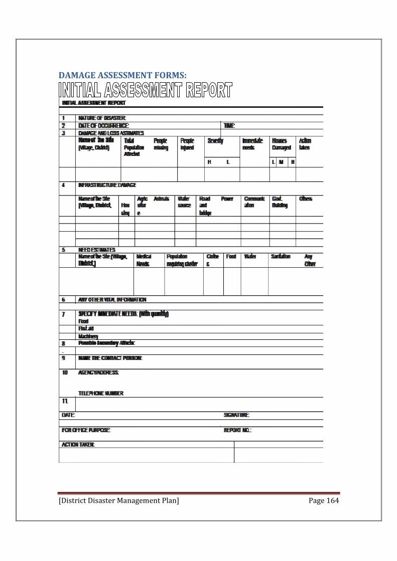
[District Disaster Management Plan] Page 164
DAMAGE ASSESSMENT FORMS:
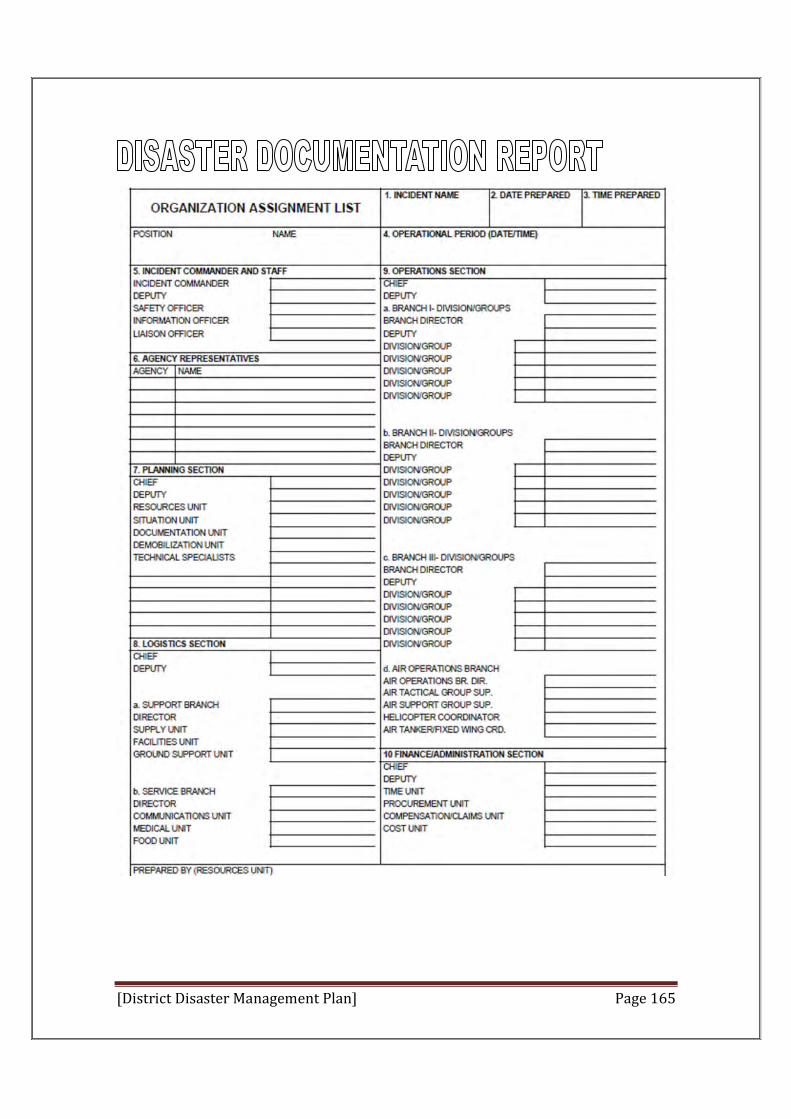
[District Disaster Management Plan] Page 165
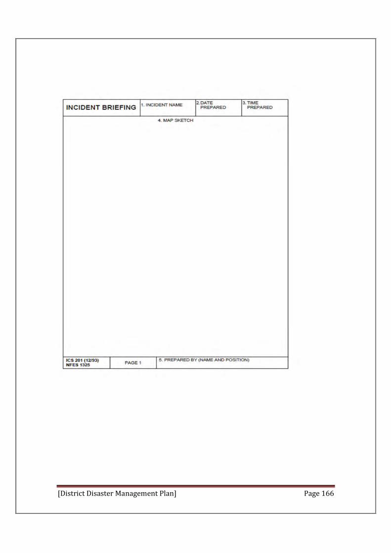
[District Disaster Management Plan] Page 166
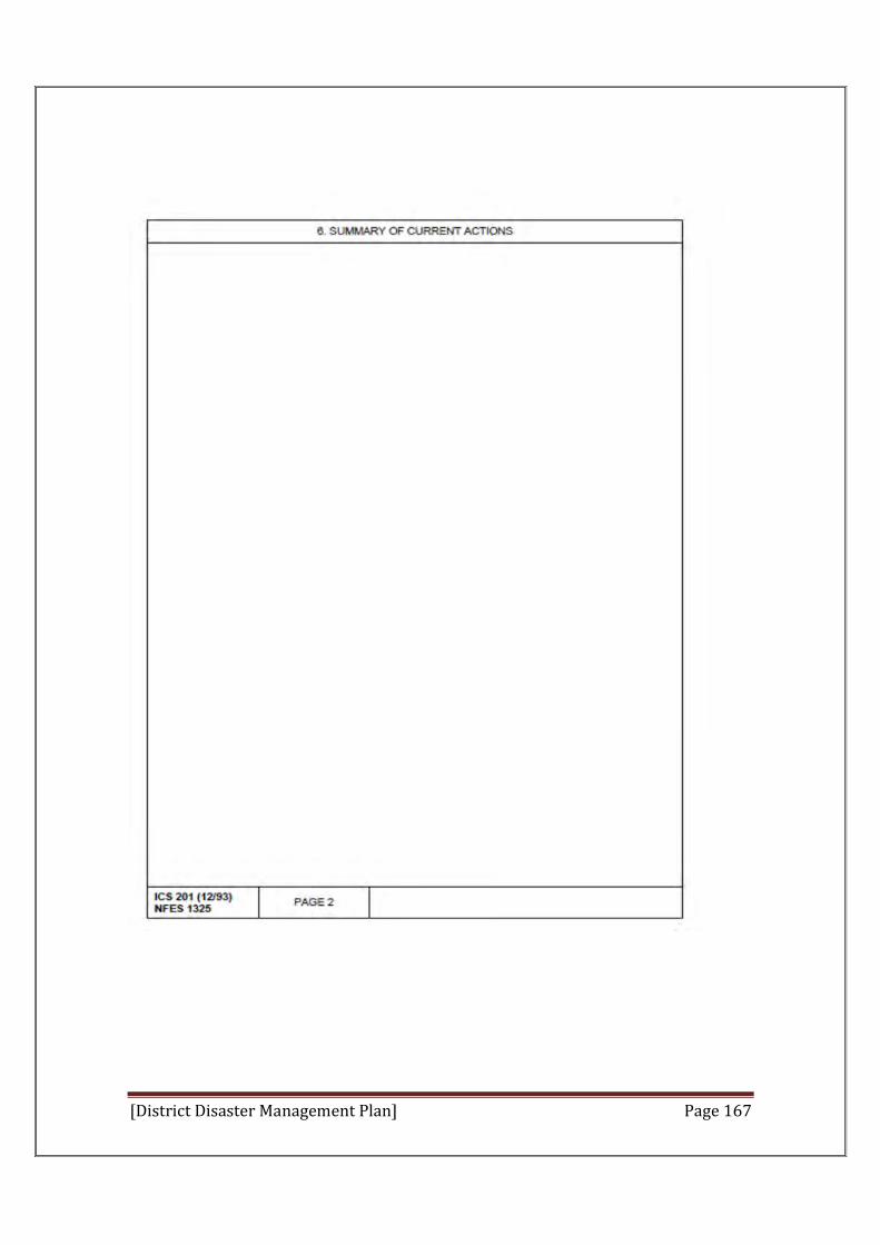
[District Disaster Management Plan] Page 167
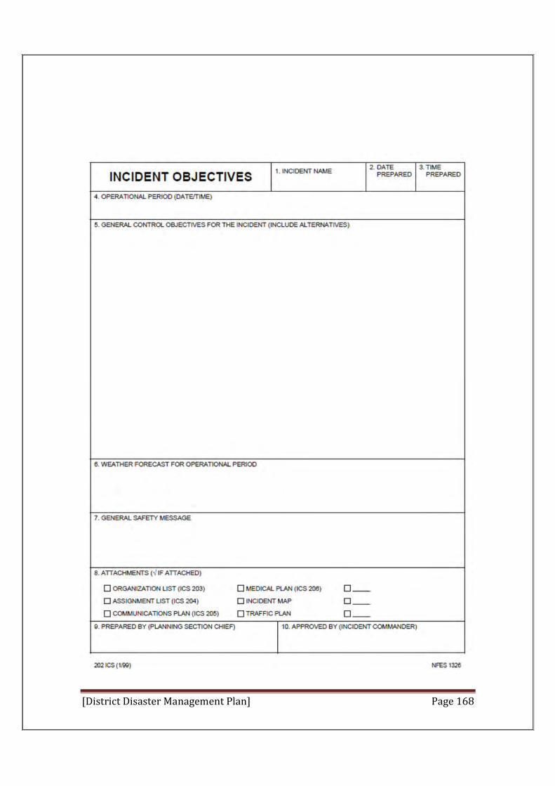
[District Disaster Management Plan] Page 168
[District Disaster Management Plan] Page 169