Embed Size (px)
Citation preview
BLM LIBRARY
88045135 United States Department of the Interior
Bureau of Land Management
Lewistown District Office September 1994
RECORD OF DECISION andRESOURCE MANAGEMENT PLAN SUMMARY
Judith-Valley-Phillips
Resource Management Plan andEnvironmental Impact Statement
HD211• M9L491994
The Bureau of Land Management is responsible for the stewardship of our public lands. It is committed to manage, protect, and improve these
lands in a manner to serve the needs of the American people for all times. Management is based on the principles of multiple use and sustained
yield of our nation's resources within a framework of environmental responsibility and scientific technology. These resources include recreation;
rangelands; timber; minerals; watershed; fish and wildlife; wilderness; air; and scenic, scientific, and cultural values.
BLM/MT/PL-95/001+1610
TD8?o4$/35
TAKE 1.
PRIDE INUnited States Department of the Interior America'
BUREAU OF LAND MANAGEMENTLewistown District Office
Airport Road
P.O. Box 1160
Lewistown. Montana 59457-1160
IN RKPI.V RKKKRTO:
/ft?
x//
•Ml
Dear Reader:
This is a copy of the Record of Decision (ROD) and the approval of portions ofthe Judith-Valley-Phillips Resource Management Plan (RMP) . This ROD approvesthe Bureau of Land Management's (BLM) decisions for managing 2,806,157 surfaceacres and 3,387,687 acres of mineral estate with the exception of decisionsrelating to oil and gas leasing and development. The land use decisions willguide future uses and activities on BLM land within the Judith, Valley, andPhillips Resource Areas.
This document has been sent to all recipients of the proposed Judith-Valley-Phillips RMP and final Environmental Impact Statement (EIS) published in
October 1992. The Lewistown District has also prepared a separate approvedresource management plan for each resource area within the Judith-Valley-Phillips planning area. The approved plan consists of those decisionspertaining to a particular resource area. Copies of the approved RMPs areavailable by writing to the respective resource area office:
Judith RMPJudith Resource AreaP.O. Box 1160Lewistown, MT 59457-1160
Valley RMPValley Resource AreaRoute 1, Box 4775Glasgow, MT 59230
Phillips RMPPhillips Resource Area501 S 2nd Street EastMalta, MT 59538
We are pleased to provide this copy for your reference and we extend ourappreciation for your cooperation and assistance during this planning process,
Sincerely,
So
<%
.YVUl^^David L. MariDistrict Manager

RECORD OF DECISIONand
RESOURCE MANAGEMENT PLAN SUMMARY
for the
approval of portions of the
JUDITH-VALLEY-PHILLIPS
RESOURCE MANAGEMENT PLANand
ENVIRONMENTAL IMPACT STATEMENT
September 1994
Prepared by
U.S. Department of the Interior
Bureau of Land Management
Montana State Office
Lewistown District Office
-&/l~<xo /^~L^\a^>~-fS / September 9, 1994
Francis R. Cherry, Jr. ^2/ Date
Acting State Director, Montana
Bureau of Land Management

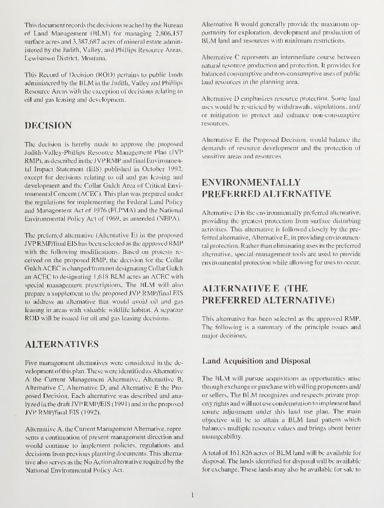
This document records the decisions reached by the Bureau
of Land Management (BLM) for managing 2,806,157
surface acres and 3,387,687 acres of mineral estate admin-
istered by the Judith, Valley, and Phillips Resource Areas,
Lewistown District, Montana.
This Record of Decision (ROD) pertains to public lands
administered by the BLM in the Judith, Valley and Phillips
Resource Areas with the exception of decisions relating to
oil and gas leasing and development.
DECISION
The decision is hereby made to approve the proposed
Judith-Valley-Phillips Resource Management Plan (JVP
RMP), as described in the JVPRMP and final Environmen-
tal Impact Statement (EIS) published in October 1992,
except for decisions relating to oil and gas leasing and
development and the Collar Gulch Area of Critical Envi-
ronmental Concern (ACEC). This plan was prepared under
the regulations for implementing the Federal Land Policy
and Management Act of 1976 (FLPMA) and the National
Environmental Policy Act of 1969, as amended (NEPA).
The preferred alternative (Alternative E) in the proposed
JVP RMP/final EIS has been selected as the approved RMPwith the following modifications. Based on protests re-
ceived on the proposed RMP, the decision for the Collar
Gulch ACEC is changed from not designating Collar Gulch
an ACEC to designating 1,618 BLM acres an ACEC with
special management prescriptions. The BLM will also
prepare a supplement to the proposed JVP RMP/final EIS
to address an alternative that would avoid oil and gas
leasing in areas with valuable wildlife habitat. A separate
ROD will be issued for oil and gas leasing decisions.
ALTERNATIVES
Five management alternatives were considered in the de-
velopment of this plan. These were identified as Alternative
A the Current Management Alternative, Alternative B,
Alternative C, Alternative D, and Alternative E the Pro-
posed Decision. Each alternative was described and ana-
lyzed in the draft JVP RMP/EIS ( 1 99 1 ) and in the proposed
JVP RMP/final EIS (1992).
Alternative A, the Current Management Alternative, repre-
sents a continuation of present management direction and
would continue to implement policies, regulations and
decisions from previous planning documents. This alterna-
tive also serves as the No Action alternative required by the
National Environmental Policy Act.
Alternative B would generally provide the maximum op-
portunity for exploration, development and production of
BLM land and resources with minimum restrictions.
Alternative C represents an intermediate course between
natural resource production and protection. It provides for
balanced consumptive and non-consumptive uses of public
land resources in the planning area.
Alternative D emphasizes resource protection. Some land
uses would be restricted by withdrawals, stipulations, and/
or mitigation to protect and enhance non-consumptive
resources.
Alternative E, the Proposed Decision, would balance the
demands of resource development and the protection of
sensitive areas and resources.
ENVIRONMENTALLYPREFERRED ALTERNATIVE
Alternative D is the environmentally preferred alternative,
providing the greatest protection from surface disturbing
activities. This alternative is followed closely by the pre-
ferred alternative, Alternative E, in providing environmen-
tal protection. Rather than eliminating uses in the preferred
alternative, special management tools are used to provide
environmental protection while allowing for uses to occur.
ALTERNATIVE E (THEPREFERRED ALTERNATIVE)
This alternative has been selected as the approved RMP.
The following is a summary of the principle issues and
major decisions.
Land Acquisition and Disposal
The BLM will pursue acquisitions as opportunities arise
through exchange or purchase with willing proponents and/
or sellers. The BLM recognizes and respects private prop-
erty rights and will not use condemnation to implement land
tenure adjustment under this land use plan. The main
objective will be to attain a BLM land pattern which
balances multiple resource values and brings about better
manageability.
A total of 161,826 acres of BLM land will be available for
disposal. The lands identified for disposal will be available
for exchange. These lands may also be available for sale to
facilitate an individual land exchange or meet other plan
objectives.
During any purchase or exchange action, the BLM will
attempt to maintain the respective county tax base and
allow no overall net gain in BLM land over the life of this
plan. The BLM will monitor land tenure adjustments to
identify potential problems in achieving this objective.
BLM land may be sold to facilitate a purchase or exchange
action or maintain the respective county tax base.
Access to BLM Land
3. Snowmobiles will be allowed off-road travel on BLMland in the Little Belt and Snowy Mountains.
4. Off-road vehicle use will be allowed for game re-
trieval. In some areas, retrieval may be restricted.
The BLM will pursue cooperative agreements with state
and local law enforcement agencies and use BLM law
enforcement rangers to monitor and implement restric-
tions.
Off-road travel for administration of a federal lease or
permit will be granted, unless specifically prohibited.
The BLM has identified 7 1 ,793 BLM acres as needing new
legal public access and 1,126,858 BLM acres needing
additional access. Access will be pursued utilizing existing
laws, regulations and guidelines. During activity planning
and/or route analysis, access may be defined as foot, horse,
or vehicular. Access will be confined to as narrow a corridor
as is necessary to serve such purpose.
The BLM will support the public road network, primarily
county roads, leading to BLM land by establishing limited
cooperative agreements for maintenance with the respec-
tive counties.
Off-Road Vehicle Designations
The BLM will designate 1 ,990,441 BLM acres open to off-
road vehicles (ORV); designate 813,769 BLM acres lim-
ited to protect the resource values in ACECs and wilderness
study areas (WSAs), protect vegetation and soils to main-
tain watersheds and water quality, reduce user conflicts,
and provide habitat security; and close 1 ,947 BLM acres to
protect the resource values in the Square Butte Outstanding
Natural Area (ONA) ACEC.
The BLM will designate and manage a 40-acre intensive
ORV use area north ofGlasgow for motorcycles and ATVs(T.29N.,R.39E., Section 34, NE1/4SE1/4).
The following exceptions will apply to the limited designa-
tions, except in the WSAs and ACECs:
1
.
Vehicle access for camping will be permissible within
100 yards of designated roads and trails. Exceptions
could be granted on a case-by-case basis through the
use of a special use permit.
2. The non-ambulatory handicapped, as defined by Mon-
tana Law, will be allowed motorized access off desig-
nated roads and trails.
Hardrock Mining
The BLM will provide for hardrock mineral development,
while protecting other resources ofexceptional value through
withdrawal from mineral entry or with special management
prescriptions. The BLM will segregate 4,647 BLM acres
from mineral entry including; 100 acres high, 100 acres
moderate, 60 acres low, and 4,387 acres very low mineral
development potential.
The BLM will recommend revoking the withdrawals for
the Judith Peak and Red Mountain Radar Sites, the Landusky
Town Site, Landusky Recreation Site and the Zortman
Town Site. The BLM will continue the Blacktail Fossil Site,
Azure Cave, Camp Creek Campground and Montana Gulch
Campground withdrawals.
The BLM will pursue protective withdrawals for the Big
Bend of the Milk River ACEC to protect the area from any
possible bentonite mining; the Square Butte ONA ACEC to
segregate the area from locatable mineral entry to protect
natural endemic systems, cultural sites, scenic qualities and
rare geologic features unique to Montana; and the Zortman
Cemetery.
To ensure orderly development of mineral resources while
protecting other resource values, management prescrip-
tions will be applied to Plans of Operation in the Judith
Mountains Scenic Area ACEC, Collar Gulch ACEC, elk
habitat in the Judith and North Moccasin Mountains and
bighorn sheep habitat in the Little Rocky Mountains. Miti-
gating measures will be applied to all Plans of Operation to
prevent unnecessary or undue degradation.
Riparian and Wetland Management of
Watersheds
The BLM will maintain and/or improve the riparian-wet-
land areas in 348 allotments with 595 BLM stream miles
and 5,850 water sources based on proper functioning con-
dition and the desired plant community.
The BLM will initially accomplish riparian-wetland objec-
tives through livestock grazing methods at current stocking
levels. If grazing methods are not successful in meeting
management objectives, the BLM will take the necessary
action to achieve those objectives. When the trend in
riparian and wetland conditions is improving, the pre-
scribed grazing method should be continued even if the
riparian-wetland objectives are not achieved in the stated
time frame.
To accomplish the above riparian-wetland objectives the
BLM will consider the importance of the intermingled
private lands, including valuable riparian-wetland areas,
which could be adversely impacted as a result of manage-
ment changes on BLM land.
Elk and Bighorn Sheep Habitat
Management
The BLM will provide 593,980 acres of habitat for elk on
BLM land in the Missouri Breaks, Highwood Mountains,
Square Butte, Little Belt Mountains, Judith Mountains, and
Little and Big Snowy Mountains.
The BLM will also provide 156,930 acres of habitat to
maintain and expand bighorn sheep on BLM land in the
planning area.
The BLM will plant lure crops on BLM land where deter-
mined to be necessary and feasible to draw elk from private
crop land where depredation conflicts are occurring. Plant-
ing lure crops will be considered for small areas and
management to protect lure crops could include fencing,
grazing methods, or a change in season of use for livestock.
Planting and maintenance of lure crops will be most fea-
sible under a cooperative arrangement with Montana De-
partment of Fish, Wildlife and Parks (MDFWP), other
organizations or individuals.
nous hawk as threatened or endangered. If one of these
species would become listed, the BLM will consult with the
U.S. Fish and Wildlife Service (FWS) to assure this RMPmeets the habitat needs. If this plan would not meet those
needs, the BLM will amend this RMP.
The BLM, in cooperation with the FWS and MDFWP, will
maintain the existing prairie dog habitat and distribution on
BLM land within the 7km Complex based on a 1988 survey.
The BLM will also support cooperative agreements for
prairie dog towns on the Charles M. Russell National
Wildlife Refuge (CMR), Montana Department of State
Lands (DSL), and private land within the 7km Complex.
The 7km Complex contains approximately 26,000 acres of
prairie dog towns (12,346 BLM acres, 5,800 CMR acres,
2,012 DSL acres and 5,821 private acres). Management
actions will be directed to cooperatively maintain this
amount of prairie dog habitat.
The BLM will maintain or manage prairie dog towns on
BLM land in the Valley and Judith RAs, based on the values
or problems encountered.
Judith Mountains Scenic Area ACEC
The BLM will designate 3,702 BLM acres an ACEC to
protect the scenic, wildlife and recreation values in the
Judith Mountains. Designation of an ACEC only applies to
public lands administered by the BLM. This area would be
managed to mitigate impacts to resources from surface
disturbing activities.
The BLM will implement the following management ac-
tions: off-road travel will be restricted yearlong to desig-
nated roads and trails; the ACEC will be an avoidance area
for rights-of-way (ROWs); the area will be available for
restricted management of forest products; and the area will
remain open to mineral entry with mitigating measures
specific to hardrock mining activities.
Acid Shale-Pine Forest ACEC
Prairie Dog and Black-Footed Ferret
Management
The BLM will provide prairie dog habitat for black-footed
ferret reintroduction and long-term ferret recovery, associ-
ate species (mountain plover, burrowing owl, and ferrugi-
nous hawk), recreational viewing, and prairie dog shooting.
Prairie dog towns on BLM land identified for reintroduc-
tion of the black-footed ferret will be designated an ACEC(12,346 acres). This habitat may also help prevent the
listing of the mountain plover, burrowing owl and ferrugi-
The BLM will designate two representative BLM tracts,
War Horse (817 acres) and Briggs Coulee (1,646 acres),
within an Acid Shale-Pine Forest ecosystem a Research
Natural Area ACEC to protect an endemic plant commu-
nity unique to the area and a fragile watershed. Designation
of an ACEC only applies to public lands administered by
the BLM. The ACEC will be a Research Natural Area
where research will be allowed to determine the effects of
grazing, fire, etc. on this type of plant community. The
BLM will allow research at War Horse and maintain Briggs
Coulee as a control site.
The BLM will implement the following management ac-
tions: disposal of forest products from the area will be
prohibited unless necessary for stand preservation; the area
will receive intensive wildfire suppression; ORV use will
be restricted yearlong to designated roads and trails; and the
ACEC will remain open to mineral entry.
Square Butte Outstanding Natural Area
ACEC
The BLM will designate 1,947 BLM acres an ACEC to
protect natural endemic systems, cultural sites, scenic quali-
ties, rare geologic features unique to Montana, and identify
key wildlife viewing sites under the Watchable Wildlife
Program. Designation of an ACEC only applies to public
lands administered by the BLM. This area will be managed
primarily for wildlife, cultural resources and recreation.
The BLM will implement the following management ac-
tions: pursue a protective withdrawal for Square Butte to
segregate the area from mining claim location; legal access
will be pursued to the ACEC; the area will be closed to
ORVs; surface disturbing activities will be prohibited in-
cluding transmission lines, roads, communication sites,
pipelines, etc.; recreation and habitat management plans for
the area will include a trail system, camping areas, a
recreation use policy and habitat management direction for
wildlife populations including prescribed fire, security ar-
eas, etc.; and the sale of forest products will be prohibited,
unless necessary for stand preservation.
Collar Gulch ACEC
The BLM will designate 1,618 BLM acres an ACEC to
protect a pure strain of westslope cutthroat trout which is a
Montana Department of Fish, Wildlife and Parks State
Species of Special Concern. Designation of an ACEC only
applies to public lands administered by the BLM. The
primary emphasis will be wildlife habitat protection and
improvement for the westslope cutthroat trout population,
with some non-motorized recreational use.
The area will be closed to motorized vehicles, except for the
main Judith Peak road and connected Big Grassy Peak and
Crystal Peak/Collar Ridge access roads. Additional public
access to the area will not be pursued to protect natural
resource values.
Developments in the area will be designed to protect trout
habitat. Stream protection and enhancement structures will
be initiated to improve trout habitat. The BLM will initiate
a study to identify the source of water quality degradation
in the drainage and develop appropriate measures to elimi-
nate or mitigate the degrading source.
Management Prescriptions for the Collar
Gulch ACEC
1
.
The BLM will implement a nondegradation policy for
the waters in Collar Gulch Creek to protect the resident
population of westslope cutthroat trout. Thenondegradation policy will apply to operations located
within the watershed; from the beginning of Collar
Gulch Creek downstream to the point where the creek
enters private land (in T.17N., R.20E., Section 32:
SE1/4NW1/4 determined is the upstream limit of the
known cutthroat trout occurrence. Variances will be
provided for individual operations only after applica-
tion of best reasonably available control technology;
and only to the extent that it will not impact the trout
population.
2. The BLM will initiate a routine water quality monitor-
ing program in the drainage to establish baseline con-
ditions.
3. Withdrawal of surface or ground water will be re-
stricted when the flow in Collar Gulch Creek drops
below 3 cubic feet per second measured at the point
where the creek enters private land in T. 17N, R.20E.,
Section 32: SE1/4NW 1/4.
4. Concurrent reclamation will be emphasized, thereby
reducing erosion and sedimentation potential.
5. Surface disturbing activities will be designed to mini-
mize impacts to the Collar Peak Trail.
6. Surface disturbing activities will be designed to avoid
impact to the Tate-Poetter Cave resources.
Azure Cave ACEC
The BLM will designate 140 BLM acres an ACEC to
protect cave resources and potentially the northernmost bat
hibernaculum in the United States. Designation ofan ACEConly applies to public lands administered by the BLM. The
cave will be managed to protect bats during crucial hiber-
nation periods and allow specific and general recreation use
on a limited basis.
The BLM will implement the following management ac-
tions: prepare an activity plan to determine time periods for
cave access and initiate appropriate management activities
to protect the bats; continue the withdrawal from mining
claim location; additional legal access will be pursued but
limited to an unimproved road; and ORVs will be restricted
yearlong to designated roads and trails.
Big Bend of the Milk River ACEC
The BLM will designate 2,120 BLM acres within the Big
Bend of the Milk River area, which includes the Henry
Smith and Beaucoup Sites, an ACEC to manage archaeo-
logical resources representing bison hunting and prehis-
toric ceremonial use of the Northwestern Plains. The Henry
Smith Site will be managed for interpretation and the
Beaucoup Site for research. Designation of an ACEC only
applies to public lands administered by the BLM.
The BLM will implement the following management ac-
tions: consult with appropriate Native Americans to ensure
that an activity plan is developed with sensitivity to Native
American cultural values; ORVs will be restricted yearlong
to designated roads and trails; and the area will be with-
drawn from mineral location and withheld from solid
mineral leaseables.
MANAGEMENTCONSIDERATIONS
The approved RMP establishes management direction to
accomplish BLM land adjustment. This RMP increases
BLM's flexibility in accomplishing land adjustment while
considering landowner preference to exchange or sell and
the effects on the local tax base.
The approved RMP addresses the problem of providing
legal access to BLM land and the expected increase in
recreation use on BLM land. It does not provide access to
all BLM land, but only those areas large enough to provide
an adequate recreational experience, and that are expected
to remain in public ownership.
The approved RMP provides for ORV restrictions to pro-
tect resource values in ACECs and WSAs, protect vegeta-
tion and soils to maintain watersheds and water quality,
reduce user conflicts, and provide wildlife habitat security.
The designations address resource conflicts and publics
concerns while recognizing the possible future demands for
ORV use on BLM land.
The approved RMP considers the hardrock mineral devel-
opment potential in the planning area along with foresee-
able activity when selecting areas open and closed to
mining claim location. The BLM choose this alternative to
leave most of the hardrock development potential lands
open to mining claim location.
The approved RMP improves or maintains riparian-wet-
land areas based on proper functioning condition and the
desired plant community. The RMP considers the trend
toward meeting this objective, while considering the im-
portance of intermingled private land which could be ad-
versely impacted as a result of management changes on
BLM land.
The approved RMP alleviates wildlife/landowner conflicts
and maintains viable elk and bighorn sheep habitat with the
potential of the land to sustain them.
The approved RMP allows for reintroduction of the black-
footed ferret in keeping with the Endangered Species Act,
provides for continued existence of prairie dogs and asso-
ciated species and minimizes impacts on local and affected
landowners and permittees.
The approved RMP designates the following ACECs: the
Judith Mountains Scenic Area to protect the scenic, wildlife
and recreation values in the Judith Mountains; the Acid
Shale-Pine Forest to protect an endemic plant community
unique to the area and a fragile watershed; the Square Butte
ONA to protect natural endemic systems, cultural sites,
scenic qualities, rare geologic features unique to Montana,
and identify key wildlife viewing sites under the Watchable
Wildlife Program; the Collar Gulch area to protect a pure
strain of westslope cutthroat trout; Azure Cave to protect
the cave resources and potentially the northern most bat
hibernaculum in the United States; and Big Bend of the
Milk River to protect archaeological resources representing
bison hunting and prehistoric ceremonial use of the North-
western Plains.
MITIGATION
The RMP has been designed to avoid or minimize environ-
mental harm where practicable. Specific mitigation mea-
sures are described in Chapter 2 of the proposed JVP RMP/final EIS (1992).
IMPLEMENTING ANDMONITORING DECISIONS
Decisions in this plan will be implemented over a period of
years depending on budget and staff availability. Funding
levels will affect the timing and implementation ofmanage-
ment actions and project proposals, but will not affect the
decisions made under this RMP. An implementation sched-
ule will be developed to provide for the systematic accom-
plishment of decisions in the approved RMP.
Decisions will be monitored to evaluate the continuing
effectiveness of the decisions in the plan. Monitoring will
provide the information needed to chart the progress being
made toward reaching the plan's stated goal and objectives.
Monitoring the land use plan will provide the following:
1. Determine if a multiple-use prescription is fulfilling
the purpose for which it was designed.
2. Determine if predictions of effects and impacts from
management actions were accurate as a basis for ap-
propriate management action.
3. Reveal unanticipated and/or unpredictable effects in-
cluding off-site impacts.
4. Determine if mitigation measures are satisfactory and
are as effective as predicted.
5. Determine if any established threshold levels have
been met or exceeded.
Implementation will be by watershed and management will
consider the streams, water sources, and uplands within that
watershed. Prioritization for implementation will begin
with the watershed containing the greatest number of group
one allotments. All allotments within a watershed will be
considered when managing for riparian-wetland values.
The resource area will determine the size of the watershed
applicable to management actions. The actual boundaries
of the selected watershed will correspond to those major,
submajor, minor, or hydrologic units as defined by the State
of Montana, Department of Natural Resources, Water Re-
sources Division. Implementation for an individual allot-
ment will consider the implications (standards and guide-
lines) and effects to the entire watershed and to other
allotments within the watershed. Exceptions will be consid-
ered for Custocial (C) allotments, if it is determined that the
amount of public land involved is to insignificant that
overall improvement in the watershed cannot take place.
6. Provide for continuing evaluation of consistency with
plans or programs of federal, state, and local govern-
ment or Indian Tribes.
7. Provide for continuing comparison of plan benefits
versus costs (social, economic, and environmental).
8. Determine if new data and/or information have af-
fected the plan, its conclusions, or estimation of ef-
fects.
9. Determine the rate and degree to which the plan is
being implemented in terms of both the decisions that
can be implemented without activity planning and
those that require activity planning.
Monitoring guidelines can be found in the Judith, Valley
and Phillips monitoring plans available at the respective
resource area offices. These guidelines will be used to
monitor implementation of specific management guidance
and actions and updated as necessary.
Inventories of riparian-wetland areas already have or will
determine functioning condition (proper functioning con-
dition, functioning at risk, or non-functioning) and the
potential to produce a certain type of plant community.
Allotments with riparian-wetland areas that are in proper
functioning condition (and apparent trend is static or up-
ward) or are functioning at risk (and apparent trend is
upward) will remain at the existing allotment category
(Improve (I), Maintain (M), or C). The riparian-wetland
objectives will be to maintain or meet proper functioning
condition and achieve the desired plant community. To
meet these objectives, grazing and other methods will
continue as specified in the permit/lease, grazing agree-
ment, or allotment management plan (AMP). The plant
communities in these riparian-wetland areas will be moni-
tored to determine if the trend is maintained or improving.
If the trend is down or static/functioning at risk, the allot-
ment will be recategorized as an I allotment and grazing and
other methods will be specified to meet the objectives as
discussed in the following paragraph.
Land tenure adjustments will be monitored to identify
changes in the respective county tax base and the net change
in BLM land.
The following inventory and monitoring requirements for
riparian-wetland areas will begin with implementation of
the plan for the six groups of allotments identified under the
Preferred Alternative in Appendix J of the proposed RMP/final EIS (1992). The allotments were ranked into these six
groups based on resource conditions and whether riparian
objectives are being met. The list of allotments will be
updated through plan maintenance based on inventories
and monitoring.
Allotments with riparian-wetland areas that are in proper
functioning condition (and apparent trend is down), func-
tioning at risk (and apparent trend is static or down) or non-
functioning will be recategorized as Category I allotments.
The riparian-wetland objectives will be to maintain or meet
proper functioning condition and achieve the desired plant
community. Grazing and other methods to meet these
objectives will be implemented during the next grazing
season. Grazing methods will be specified in the permit/
lease, grazing agreement, or AMP. The plant communities
in these riparian-wetland areas will be monitored for two
years immediately following implementation of the graz-
ing methods to determine if the trend is improving to meet
proper functioning condition. If the trend is not improving,
the necessary action will be taken the next grazing season
to achieve an upward trend toward proper functioning
condition and the desired plant community.
Figure 1 shows the general implementation schedule for
riparian-wetland management. A specific implementation
schedule will be prepared for the allotments with riparian-
wetland areas. This specific implementation schedule will
maintain the time frame shown in Figure 1 and will be
updated each year based on additional inventory and moni-
toring.
MAINTAINING AND AMENDINGDECISIONS
Decisions in this plan will be maintained to reflect minor
changes in information. Maintenance is limited to refining
or further clarifying a plan decision and cannot expand the
scope of the decision nor change the terms or conditions of
the decisions. Maintenance will be documented in support-
ing records. A plan amendment may become necessary if
major changes are needed or to consider a proposal or action
that is not in conformance with the plan. Plan amendments
are accomplished with public input and environmental
analysis.
PUBLIC INVOLVEMENT
CONSISTENCY
This plan is consistent with the plans, programs, and poli-
cies of other Federal, state and most local governmental
agencies. The BLM cannot be entirely consistent with the
Fergus, Petroleum, or Valley County Interim Land Use
Policy Plans. As currently written, these Policy Plans have
portions which are not consistent with federal laws and
regulations.
PUBLIC AVAILABILITY OF THISDOCUMENT
Copies of the ROD are available from the Lewistown
District Office, Airport Road, P.O. Box 1 160, Lewistown,
MT 59457- 1 1 60. The Lewistown District has also prepared
a separate approved resource management plan for each
resource area within the Judith-Valley-Phillips planning
area. The approved plan consists ofthose decisions pertain-
ing to a particular resource area. Copies of the approved
RMP's are available by writing or contacting the respective
resource area office:
Phillips RMPPhillips Resource Area
501 South 2nd St East
Malta, MT 59538
(406)654-1240
Valley RMPValley Resource Area
Route 1, Box 4775
Glasgow, MT 59230
(406)228-4317
The views and concerns of the public were actively solic-
ited throughout this planning process. Public involvement
and coordination is summarized in Chapter 5 of the pro-
posed JVP RMP/final EIS.
Judith RMPJudith Resource Area
P.O.Box 1160
Lewistown, MT 59457-1 160
(406)538-7461
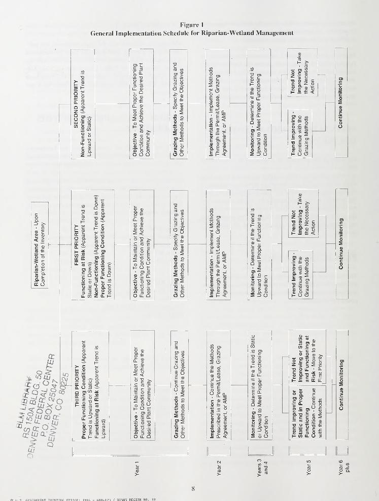
Figure 1
General Implementation Schedule for Riparian-Wetland Management
coQ.Z> c*
oCO c0)k.
<DC(0
CD>
CDx:
a o5 c
oc(0 CD
Q.CO E
oDC O
CD
H
Ell5E «
i &
ffi oc
"-roe°> IBg.2 oo yisLL CO
O CDQco
CO Q.
it2 Ci- o
^co o£o< O)— c
.£ o „c ? co o g•s £ oo 3 Qit »
o S £z a. h
czui a-
e
> LU«? Q0/
en rc 03
co a.
no (I)
c-1 OT
II CI)
i_ QCDQ.O
<D
n CD
a)
>CD
CD r:> u
<roH u
rm >.
CD
>'•3
uCD
co
-or
3EFn o o
O O O
CD
s <° c £*£ co cco c ^c O Ei=ES ? oo o OHO ^i CO CO
> i|" -2 3
LL QSi.
o
cco co
? JN OCO CD
*2**
co
CD
O co
<u o
L?2
(3 O
® NSE CO
c c5CD -
E CD
Q. CD
^0_§ cd<•J CL O.2 CD -
a>
cb E3 CD
a e -Ex: co_ H <
CD.*CO
H £•• CO
ndNotroving
Necess
on
1
c
TreImp the
Acti o"Eo?0)3
• CO) CD CO **Cru c> ** ° oo £ £ U
E CDS
— 3 en
D .<= £C T N2 o 21- O CD
"2 a>
I 1I- gCD t3£ c,
— ^- LLCD ,_C CD
E o2 (tCD «-Q s
.£ 2 c
pli^cS
CD.^10 ^1- £>
CO
id
Not
roving
Necess
on
COc
TreImp the
Acti o'Eo?CD3C
O) CD CO 4-»
c .c -a C> *- oo £ £
ou
E CD ^— 3 enxi £ £C t= NSi § £1- O CD
u
c XJ CO
CD en ,_ CO 8 CO c/>
Y n
(Appa
t
Trend
CD
it §~ -
| 01 &£ >N ~CO ocd£s> oC•4= sz
<j
."IO co
£ "a<D O
Vation
-
Continue
the
Metho
n
the
Permit/Lease,
Grazin
or
AMP
CO CO
§ .2
THIRD
PRIORIT
ctioning
Conditio
ward
or
Static)
gat
Risk
(Apparen
To
Maintain
or
Me
Condition
and
Ach
nt
Community
§£ LL
—CL
c oE it
S a3
Q 21 o
C Ql f- ' CO CO
ment
r
ibedment
O)*'
rFu
isU ioni
d)tive
onindPI
Monitorin
or
Upward
Condition
Prope TrendFunct Upwa Objec
Functi Desire
'n
S £(5 O
Imple PrescAgree
o *-*- co
r(0 CO
tf) co
k. co o >>
** CO >
iluc-1
O2 o
T3 O 11• 0.
S Q-T3J£
00
il cCO E LL
Cl>
S 213r
co o.£ n o
CO•D
g c COO JZ
a-o cr
E = c o— (0 o CD
o oc s0) A3
t) -ax:
c3
co £
H 0) LL o 5
CO
>
co^
co ?Oci
LO CD1_ ._ CO
CO CO =5
CD Q.> >
ir III. r.nVFKNMFNT PRTNTTNC OFFTfE: 1 QQ4 - 6R9-121 / 01505 REGION NO. 10
(0T3 O^ C -P(Ti (fl W Ccn J -h OrH £ -H
<^ OiJ-H
QW
Id Z
Q HId
05
HD 211 .M9 L49 1994
U s Bureau of Land
Management. Lewistown
Record of decision and
resource manaaement p Ian
pr t>.
-<ARYIA RLDG. 50
AL CENTER^5047
20 80225